The Chinese Meteorological Society
Article Information
- LI, Liangliang, Jian LI, Haoming CHEN, et al., 2019.
- Diurnal Variations of Summer Precipitation over the Qilian Mountains in Northwest China. 2019.
- J. Meteor. Res., 33(1): 18-30
- http://dx.doi.org/10.1007/s13351-019-8103-4
Article History
- Received June 15, 2018
- in final form October 8, 2018
2. University of the Chinese Academy of Sciences, Beijing 100049
The distribution of rainfall is extremely complex in mountainous regions. Additionally, the features of hourly rainfall are closely related to the distributions of topography because of the influences of underlying topographic scales and strong interactions of topography with the atmosphere (Bonacina et al., 1945; Basist et al., 1994; Prudhomme and Reed, 1999). Previous analyses have shown that many factors of mountainous topographies, including elevation, relief, slope, and orientation, influence rainfall features (Burbank et al., 2003; Weisse and Bois, 2001; Li et al., 2014). The most obvious phenomena are that the mountains and windward slopes receive greater amounts of rainfall than the adjacent lowlands and leeward slopes due to the dynamic and thermodynamic effects of the mountains (Prudhomme and Reed, 1999). The diurnal rainfall peak in complex topographic regions also shows obvious regional characteristics. Generally, late-afternoon peaks appear in mountainous areas while nocturnal peaks appear in valleys (Fujinami et al., 2005; Qian et al., 2010; Chen et al., 2012).
The Qilian Mountains possess typical mountainous topographies in the arid and semi-arid regions of the Eurasian continent and are located in the northeastern part of the Tibetan Plateau, as shown in Fig. 1a. The Qilian Mountains include many mountains ranging from southeast to northwest, and the average elevation of these mountains is greater than 4000 m (Jia et al., 2014). The Qinghai Lake, the largest salt-water lake in China, is located in the southern region of the Qilian Mountains. The famous Hexi Corridor of China is nestled in the northeastern region of the mountains (Fig. 1b). Due to the strong “water enhancement effect,” the Qilian Mountains have very rich water vapor content and abundant rainfall on the ground (Ding, 2003; Gou et al., 2005). Many rivers originate in the Qilian Mountains, such as the Heihe and the Shule rivers, which flow through the Hexi Corridor. Thus, the Qilian Mountains are natural reservoirs of the Hexi Corridor and play an extremely important role in protecting the ecological security of western China (Zhang et al., 2014).
Previous studies of rainfall over the Qilian Mountains have mainly concentrated on the daily characteristics of rainfall (e.g., Zhang and Li, 2004; Li et al., 2010). As an important rainfall feature, the diurnal cycle of rainfall is a key aspect of regional climate and is sensitive to many processes (Li et al., 2017). Characterizing the diurnal variations of rainfall helps us understand not only the mechanism of rain formation but also the regional rainfall variations (Yu et al., 2007). Especially, in regions of complex topography, the regional characteristics of hourly rainfall reflect the importance of local circulations forced by topography (Barros and Liang, 2003; Chen et al., 2012; Li et al., 2017). However, few studies have reported on the rainfall diurnal cycle over the Qi-lian Mountains. Using ground-based GPS and observations from three weather stations over the Qilian Mountains, Liang et al. (2010) showed that the diurnal and semi-diurnal cycles could well represent the diurnal variations of precipitable water vapor (PW), and the diurnal cycle of PW has peaks appearing in late afternoon, whereas the semi-diurnal cycle is generally weaker with peaks appearing in both early morning and late afternoon. It has also been reported that the peak appears 2.5 h later in the hourly accumulated precipitation frequency than in the PW, while the peak of hourly accumulated precipitation amount is not related to that of the PW. By analyzing the hourly merged precipitation dataset derived from the national automatic weather stations and the CMORPH (Climate Precipitation Center Morphing) product on a 0.1° × 0.1° resolution, Liu et al. (2016) found that the spatial distribution and temporal variation in the mean hourly precipitation amount and frequency are generally similar, and night rain frequently occurs in the Qilian Mountains.
These previous studies yielded somewhat inconsistent results in this area. Additionally, the diurnal variations in rainfall related to regional topographies have not been investigated in detail. Therefore, using the high-density hourly rain-gauge data from 265 stations, detailed characteristics of the hourly rainfall amounts, frequencies, intensities, and durations in the different topographic areas over the Qilian Mountains are investigated in this paper. In addition, the relationships between the diurnal characteristics and the underlying topographies will also be revealed.
2 Data and methodsThe quality-controlled hourly rainfall data were obtained from the National Meteorological Information Center (NMIC) of the China Meteorological Administration. This dataset has undergone strict quality control (extreme value checks, internal consistency checks, and time consistency checks). In this study, the summertime hourly rainfall data from 265 rain-gauge stations during 2009–16 are used for the analysis. To minimize the impact of missing values on the analysis, all stations have more than 515 days without missing or suspicious values during the study period 2009–16.
The distribution of the 265 stations is shown in a topographic map in Fig. 1b. The elevations of most stations (87.2%) are below 3000 m. This is because these stations are located in the slopes and valleys of the mountains with relatively low elevations. Only 12.8% of the stations are located on mountain tops with elevations above 3000 m.

|
| Figure 1 Locations of the (a) Qilian Mountains and (b) 265 rain-gauge stations (red dots). Gray shadings indicate the elevation (m). |
In this study, a rainfall event is defined as having commenced when measurable rainfall (≥ 0.1 mm h–1) occurred after 2 or more dry hours. The standardized diur-nal amplitude is defined as the daily maximum anomaly of rainfall (the daily maximum of rainfall minus the daily mean value) divided by the daily standard deviation. The definitions of the four rainfall features in this study are depicted as follows:
(1) Rainfall amount (frequency): Cumulative amount (total hours) with measurable rainfall divided by the number of non-missing hours during the study period (summertime of 2009–16).
(2) Rainfall intensity: Cumulative rainfall divided by the number of rainy hours during the study period.
(3) Rainfall duration: The number of hours from the beginning to the end of the event, during which time there was no interruption, or at most, only a 1-h interruption occurred (Yu et al., 2007).
Since the majority of the annual rainfall occurs during summer (June–August) (Yin et al., 2009), our study focuses only on the summer hourly rainfall in the Qilian Mountains.
3 Climatic features of diurnal variation 3.1 Overall features of diurnal variationPrior to analyzing the diurnal variations of rainfall, we examined the climatological patterns of summer mean rainfall amount, frequency, intensity, and duration as shown in Fig. 2. The rainfall amounts and frequencies have distinct differences for stations with different gauge elevations (Figs. 2a, b). Large rainfall amount (frequency) values, i.e., those above 2.3 mm day–1(10.0%), appear over the middle and eastern sections of the mountains and the Qinghai Lake areas. The lowest amounts (frequencies) of rainfall are found in the northwestern Hexi Corridor (north of 39.5°N). The average summer rainfall amounts (frequencies) are less than 0.5 mm day–1 (3.0%). The rainfall distribution varies by a large amount (frequency) between the stations over mountainous areas (elevation greater than 2700 m) and the surrounding low lands (with elevation less than 2100 m). The average rainfall amounts and frequencies are more than 2 times greater over the mountainous areas (approximately 2.2 mm day–1, 10.4%) than over the surrounding low lands (approximately 0.9 mm day–1, 5.0%). Additionally, the rainfall amounts and frequencies decrease from the mountains to the northeastern and southeastern low lands. Along the northeastern slope of the mountains, the average rainfall amounts gradually increase from approximately 0.6 mm day–1over the northwest to 2.1 mm day–1over the southeast. Rainfall frequency also has a similar increasing trend. Differing from the spatial distributions of the rainfall amounts and frequencies, the stations with relatively low rainfall intensity values (e.g., average value of 0.71 mm h–1) across the entire Hexi Corridor and those with relatively large values are not obviously concentrated (Fig. 2c). However, we can still identify that the mountainous areas have larger average values (0.88 mm h–1) than those observed (0.74 mm h–1) in the surrounding low lands. Differing from the spatial distribution of rainfall amounts, frequencies, and intensities, the region of maximum durations is not located over the mountainous areas but is over the two slope regions [(38.0°–38.8°N, 100.0°–101.5°E) and (37.0°–37.8°N, 102.5°–103.5°E)] (Fig. 2d). The average duration values in the two regions are 4.5 and 4.4 h, respectively. Along the northeastern slope of the mountains and the Hexi Corridor, there is a trend of increasing duration. The duration ranges from below 3.2 h (northwestern Hexi Corridor) to above 4.5 h (38.0°–38.8°N, 100.0°–101.5°E).
Notably, the regions with large rainfall amounts (greater than 2.3 mm day–1) comprise 49 stations, and the rainfall frequencies of all 49 stations are greater than 10.0%. In addition, the rainfall intensities at 39 (79.6%) stations are greater than 0.88 mm h–1 (Figs. 2a–c). The spatial correlation coefficient between the rainfall amounts and frequencies (intensities) in large value regions (where rainfall amounts are greater than 2.3 mm day–1) is nearly 1.0 (0.7). This coefficient indicates that most stations with large rainfall amounts also have large rainfall frequencies and intensities. Our findings differ from those obtained from the hourly merged precipitation dataset derived from the national automatic weather stations and the CMORPH (Climate Rainfall Center Morphing) product on a 0.1° × 0.1° resolution, for which the rainfall intensity does not have a large value region and is similar to the amount and frequency values (Liu et al., 2016).

|
| Figure 2 Summer mean rainfall (a) amount (colored dots; mm day–1), (b) frequency (colored dots; %), (c) intensity (colored dots; mm h–1), and (d) duration (colored dots; h) averaged over 2009–16. Gray shadings indicate the topography (m). |
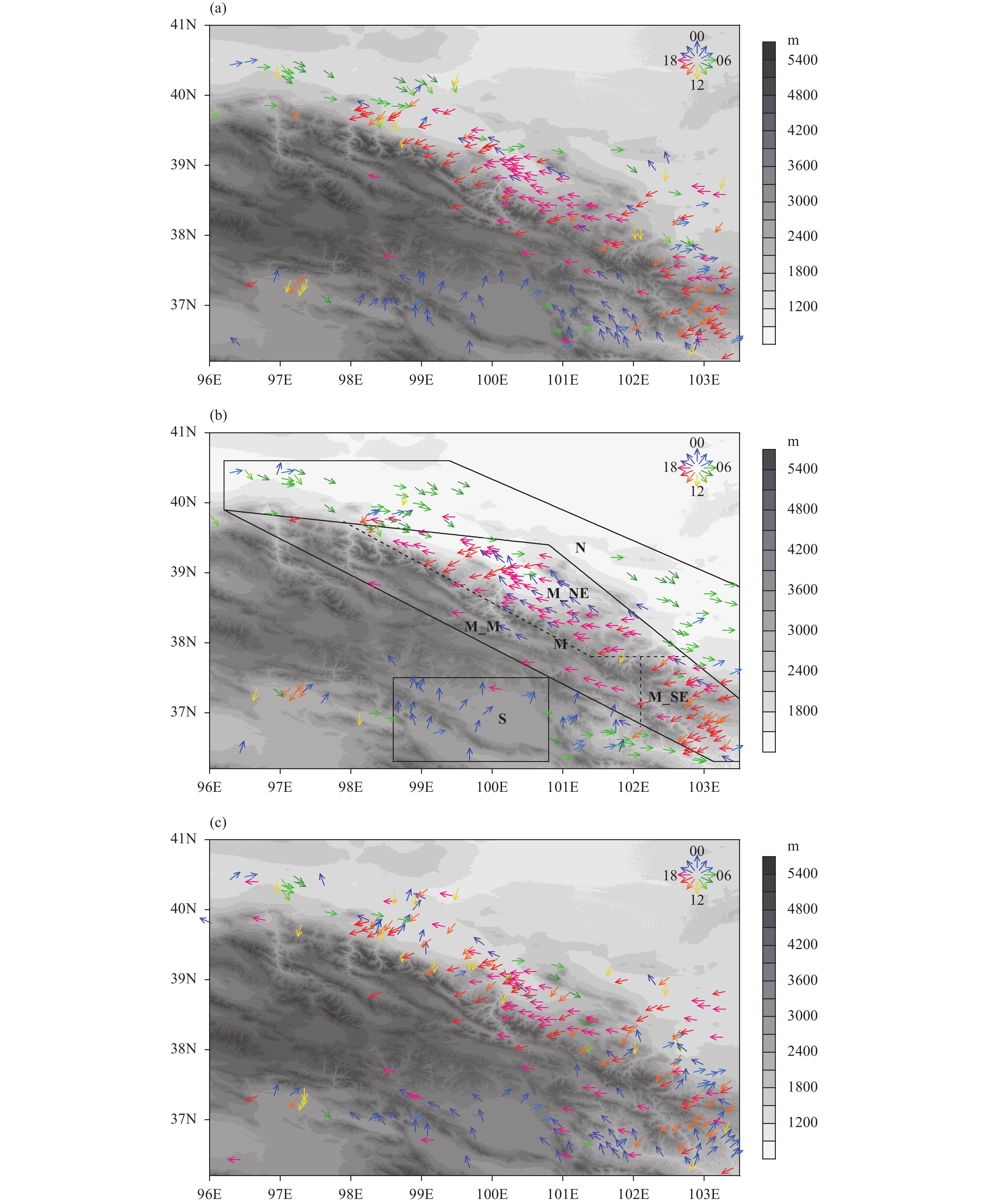
The spatial patterns of the hourly peak over 24 h for the summer rainfall amounts, frequencies, and intensities are shown in Fig. 3. The spatial distribution of the diur-nal peak of rainfall amount has obvious regional characteristics (Fig. 3a). The prevailing late-afternoon peaks [1400–2000 local standard time (LST)] appear over the major mountain ranges, including the southeastern corner (east of 102.2°E) and northeastern slope of the mountains (north of 38°N). In addition, the stations with late-afternoon peaks account for up to 52.8% of all stations. The peak hours of rainfall in the northeastern slope appear approximately 1–2 h later than those in the southeastern corner. The stations with nocturnal peaks (2100–0300 LST) account for the same number (17.4%) of stations as those with an early-morning peak (0400–1000 LST). More than half of the stations (54.3%) with early-morning peaks are concentrated in the northern Hexi Corridor, and the remainder of the stations with early-morning peaks are dispersed across the northern surrounding areas of the mountains. The stations with nocturnal peaks are located around Qinghai Lake on the southern slope of the Qilian Mountains (south of 37.5°N, 98.0°–102.2°E). Rainfalls also have nocturnal peaks over many lakes over the central Tibetan Plateau (Singh and Nakamura, 2009).
The pattern of diurnal peaks in rainfall frequencies is very similar to that of the rainfall amount, as shown in Fig. 3b. Three different regions of diurnal peak in rainfall frequency can be clearly identified. A total of 50.6% of the stations have late-afternoon peaks, which are distributed over the major mountain ranges. In contrast, 32.1% of the stations have early-morning peaks and are mainly located in the northeastern plain. Finally, 14.3% of stations have nocturnal peaks and lie around Qinghai Lake.
Compared with the patterns of rainfall amounts, there are three significant features that can be observed in the pattern of the rainfall frequency (Figs. 3a, b). One feature is that the stations with early-morning peaks are more abundant over the northeastern plains of the mountains, and the stations with nocturnal peaks in rainfall amounts have early-morning peaks of frequency to the east of Qinghai Lake (south of 37.0°N, 100.7°–101.7°E). The second feature is that the diurnal peaks at some stations appear at approximately 1900–2000 LST over 38.0°–39.0°N, 100.0°–101.0°E, which is 1–2 h behind the peak of rainfall amount. The last feature is that the peak differences were obvious in the area 36.0°–38.0°N, 101.0°–102.0°E, where the amount shows nocturnal peaks and the frequency is mainly characterized by early-morning peaks.
The diurnal peaks in rainfall intensity mainly appear during two periods (Fig. 3c). Late-afternoon peaks (55.5% stations) appear north of 37.5°N. Nocturnal peaks (24.5%) appear around Qinghai Lake and its eastern areas. Two inverse peaks appear in the southeastern corner of the mountains. One peak is nocturnal and the other is a late-afternoon peak. This finding indicates that heavy rainfall occurs more easily during nighttime and late-afternoon periods in the southeastern corner of the mountains. Compared with the patterns of rainfall amounts and frequencies, one obvious phenomenon is that the number of stations (24.5%) with early-morning peaks is significantly reduced (Figs. 3a–c). This result is consistent with the results for contiguous China (Yu and Li, 2016).
Based on the spatial patterns of the diurnal peaks in rainfall amounts, frequencies, and intensities, we can conclude that the late-afternoon peaks and nocturnal peaks are the main diurnal peaks over the mountains. For rainfall frequency, early-morning peaks also prevail. For 22.3% of stations, the diurnal peaks in the rainfall amounts, frequencies, and intensities have uniform late-afternoon peaks. For 4.2% of stations, the diurnal peaks in the rainfall amounts, frequencies, and intensities show uniform nocturnal peaks. Compared with the spatial patterns of diurnal peaks in rainfall amounts and intensities, the patterns of rainfall frequencies show more obvious differences over different topographies of the Qilian Mountains (Figs. 3a–c).
3.2 Regional differences in the diurnal variationTo illustrate the detailed diurnal cycle features of rainfall in the Qilian Mountains and to facilitate further discussion, we selected three typical regions by considering the patterns of the diurnal peaks in rainfall amounts, frequencies, and intensities and by giving priority to the frequency, as shown in Fig. 3b. These three regions represent the early-morning peak region, late-afternoon peak region, and nocturnal peak region, which are referred to as the N, M, and S region, respectively. In the N region, the percentages of stations with early-morning peaks are 49.1%, 82.6%, and 23.1% for rainfall amount, frequency, and intensity, respectively. In the M region, the percentages of stations with late-afternoon peaks are 87.9%, 89.3%, and 66.4% for rainfall amount, frequency, and intensity, respectively. In the S region, the percentages of stations with nocturnal peaks are 72.2%, 61.1%, and 47.2% for rainfall amount, frequency, and intensity, respectively. The M region contains complex topography with varied mountain tops and different slopes. To verify whether there are differences in diurnal evolutions for different topographies, the M region is divided into three subregions, which are referred to as the M_NE, M_M, and M_SE regions, and these three subregions represent the northeastern slopes, mountain tops, and southeastern slopes, respectively.
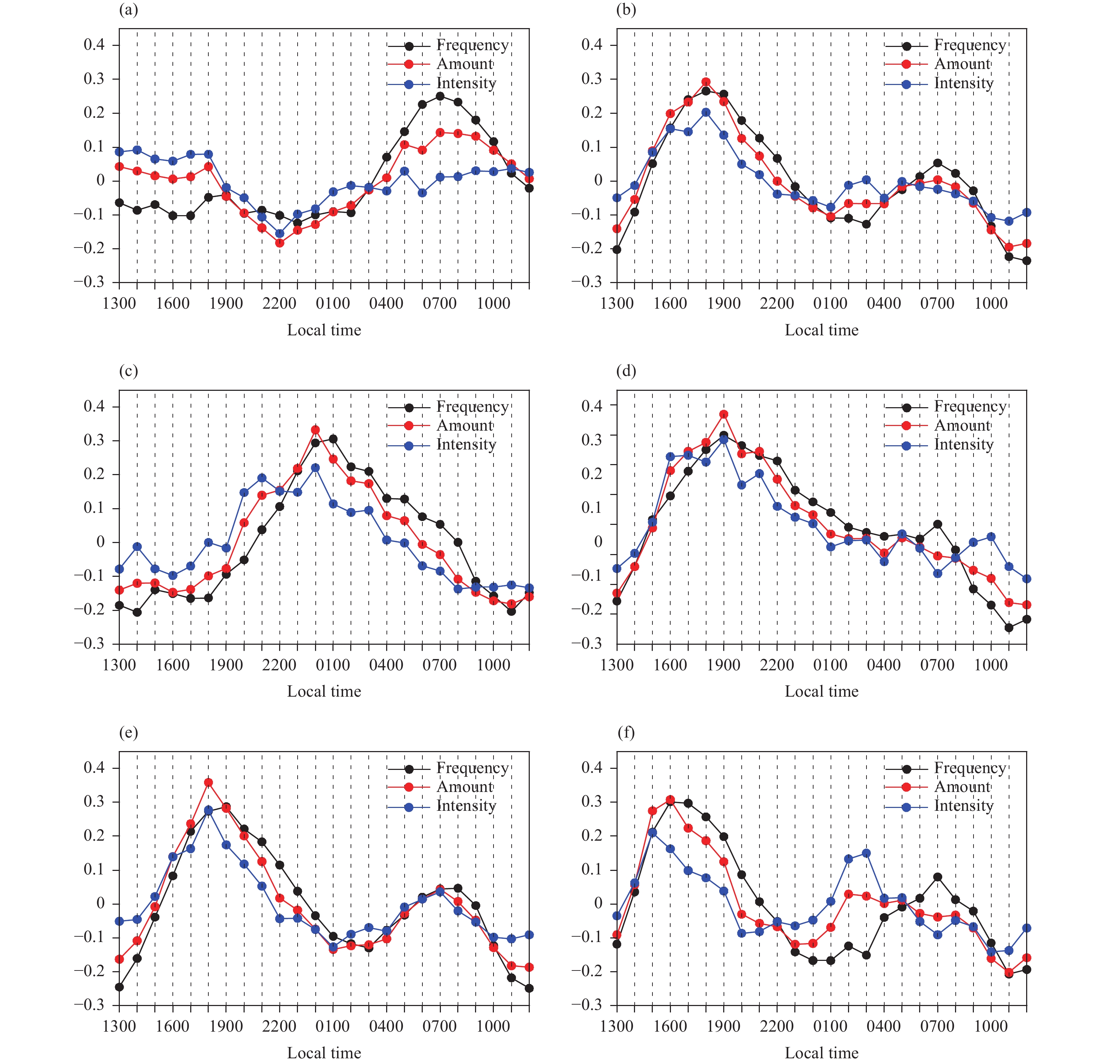
Figure 4 shows the standardized diurnal curves of the summer rainfall amounts, frequencies, and intensities averaged over each region/subregion outlined in Fig. 3b. For the N region (Fig. 4a), both the mean rainfall amounts and frequencies reach their diurnal maximum values at approximately 0700 LST, with standardized diurnal amplitudes of approximately 0.1 and 0.2, respectively. The mean rainfall intensity does not show obvious diurnal cycles except for the nocturnal minimum at approximately 2200 LST. For the M region (Fig. 4b), one strong late-afternoon peak occurs at approximately 1800 LST in the rainfall amount, frequency, and intensity, which is the same as the phenomena shown in Fig. 3, and the standardized diurnal amplitudes are approximately 0.3, greater than 0.25 and approximately 0.2, respectively. Additionally, another weaker peak at approximately 0700 LST is observed in the rainfall amount and frequency, while two weaker peaks at approximately 0300 and 0500 LST appear in the rainfall intensity. For the S region, the rainfall amount (intensity) and frequency show single nocturnal peaks at approximately 0000 (0100) LST. The standardized diurnal amplitudes are approximately 0.3, 0.3, and 0.2 for the rainfall amount, frequency, and intensity, respectively. Figures 4d–f show the diurnal variations in rainfall in the M_M, M_SE, and M_NE regions. Although the diurnal peaks of these three regions appear in the late afternoon, the detailed diurnal rainfall cycles are different. Rainfall in the M_M region shows a single peak and its standardized diurnal amplitude is approximately 0.3. The rainfall amount, frequency, and intensity increase rapidly starting at 1300 LST, reaching peaks in the late afternoon (1900 LST) and then decreasing relatively slowly. Additional analysis shows that 83.3% of stations only have a single late-afternoon peak over the M region, which indicates that region M is representative. For the M_NE and M_SE regions, the diurnal cycle of the rainfall amount (frequency and intensity) shows one strong late-afternoon peak and another weak early-morning peak, and the standardized diurnal amplitudes are comparable for the two regions. The dominant late-afternoon peak is consistent with the phenomena over southeastern Tibetan Plateau, wherein the stations have consistent late-afternoon peaks over the slopes (Chen et al., 2012). For the two mountain slopes, there are two obvious differences. One difference is that the late-afternoon rainfall amount (frequency and intensity) peak in the M_SE region appears 2 (3 and 3) h earlier than that in the M_NE region. The other difference is that the weaker peak in the rainfall amount (frequency and intensity) appears in the early morning at approximately 0700 (0800 and 0700) LST for the M_NE region. However, only the weaker frequency peak occurs in the early morning (0700 LST) for the M_SE region, and that of the rainfall intensity (amount) occurs after midnight at approximately 0300 (0200) LST, which causes a weak peak at 0300 LST in the M region (Fig. 4b).
|
| Figure 3 Diurnal peaks of summer rainfall (a) amount, (b) frequency, and (c) intensity, averaged across 2009–16. The frames and letters in (b) are the ranges and names of the typical regions. |
|
| Figure 4 Mean standardized diurnal cycle of the summer precipitation amount (red lines), frequency (black lines), and intensity (blue lines) for (a) N, (b) M, (c) S, (d) M_M, (e) M_NE, and (f) M_SE regions. |
For every region, the diurnal variations in rainfall amounts can be attributed by those of both the rainfall frequency and rainfall intensity. This phenomenon is consistent with the conclusions found for most of eastern China (Zhou et al., 2008). In addition, the peak in rainfall intensity precedes the peak in rainfall frequency over every region. This result is consistent with the previous findings that the phase of rainfall intensity (frequency) precedes (lags) the rainfall amount (Yu and Li, 2016). Yu and Li (2016) also indicated that this occurs due to the asymmetry of precipitation processes and the evolution of convective clouds.
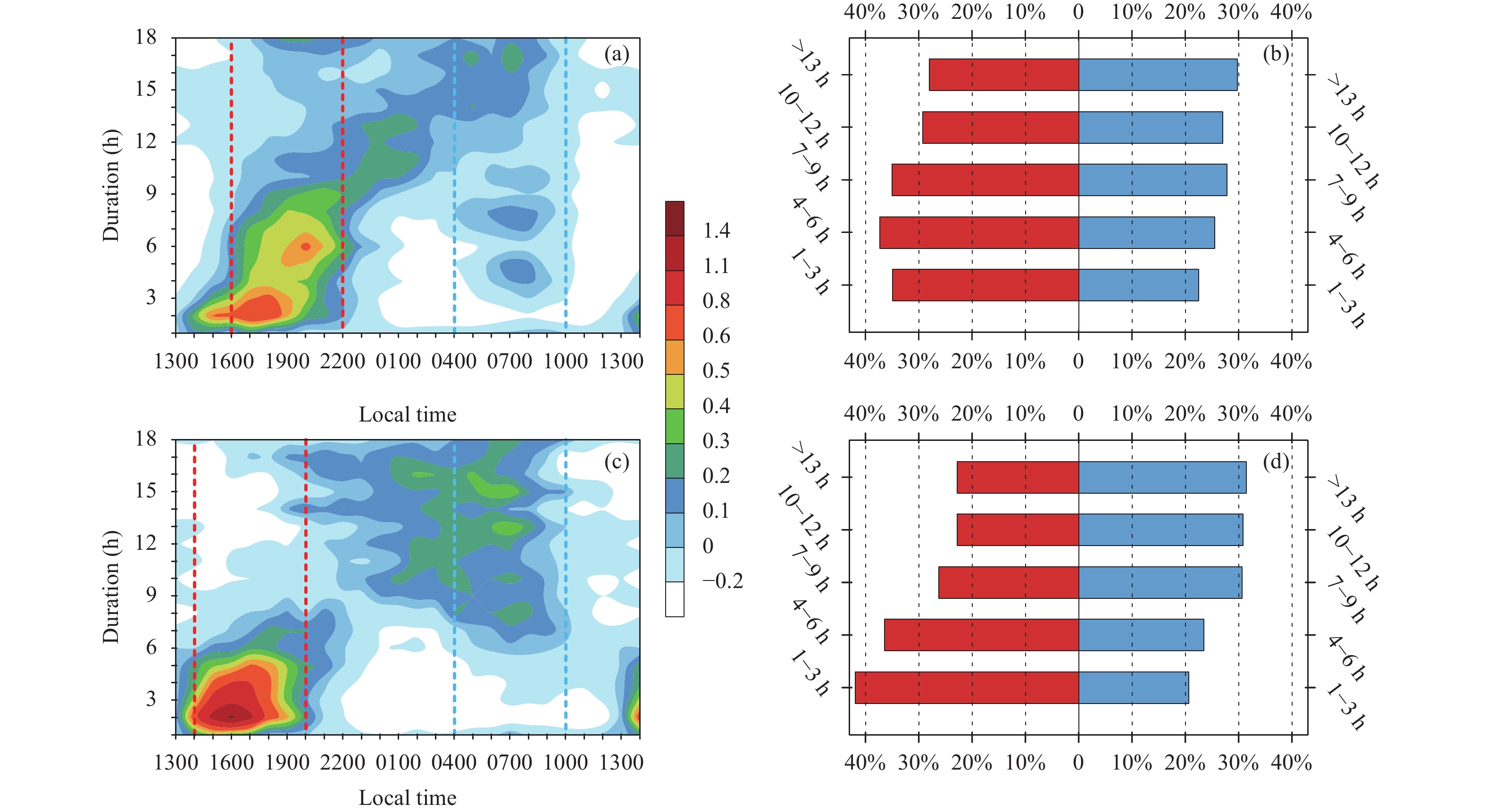
The diurnal cycle of rainfall is closely related to the duration of rainfall events (Yu et al., 2007). Over the northeastern and southeastern slopes, the diurnal cycles of rainfall frequency show double peaks, as shown in Figs. 4e, f. To explore the relationships between the double peaks in rainfall frequency and the duration over the two slopes, the rainfall frequency decomposed by duration and diurnal phase for the two slopes is analyzed, and the rainfall frequency is normalized by the daily mean of each duration time (Figs. 5a, c). We also calculated the proportions of rainfall frequency occurring during the two periods (dashed lines in Figs. 5a, c) to the total daily rainfall. Here, the two periods (hereafter referred to as peak periods) were defined as three hours before and after peak hour in Figs. 4e, f, including the late-afternoon period and the early-morning period. Figures 5b, d show the proportions of two peak periods for rainfall events with different durations. For the M_NE region, there is a large value zone during the late-afternoon period, which has a duration of less than 9 h. For these rainfall events, more than 35% of rainfall frequency is from the late-afternoon period. When the duration is between 10 and 12 h, the maximum rainfall occur in the nighttime and the rainfall in the late afternoon is slightly more than the rainfall in the early morning. When the duration is greater than 13 h, the largest value is located in the early-morning period, and rainfall in this period accounts for 30% of daily rainfall. During the early-morning period, several large centers have durations of 4–6 h, 7–8 h, and longer than 13 h, and their proportions show little difference (Figs. 5a, b). Over the southeastern slope, the large value region in the late-afternoon period has the duration shorter than 6 h and has a very large magnitude. The result indicates that the late-afternoon peak mainly comes from rainfall shorter than 6 h. When the duration is greater than 6 h, the large regions appear in the early-morning period and the proportions in this period are obviously greater than those in the late-afternoon period. That is, the late-afternoon peak is characteristic of rainfall shorter than 6 h, while the early-morning peak is contributed by events longer than 6 h. Our results indicate that the strengths of the late-afternoon and early-morning peaks in rainfall frequencies are closely related to the rainfall events with different durations over the two slopes: for rainfall events shorter than 6 h, the proportion in the late-afternoon is greater than that in early-morning, while for events longer than 13 h, the early-morning peak is stronger than the late-afternoon peak. With an increased duration, the occurrence time of rainfall becomes increasingly disperse in a day. There are some distinct characteristics over the two slopes. When the duration is between 7 and 12 h, the proportion in the late-afternoon period is greater than that in the early-morning period for the northeastern slope, but the proportion in the late-afternoon period is less than that in the early-morning period for the southeastern slope.
|
| Figure 5 (a, c) Rainfall frequency with different durations and diurnal phases in regions of (a) M_NE and (c) M_SE. The rainfall frequency is normalized by the daily mean for each duration time. The red (blue) dashed lines denote the late-afternoon (early-morning) period. (b, d) The proportions of rainfall frequency in the late-afternoon (red bars; %) and early-morning (blue bars; %) periods for rainfall events with different durations to their daily rainfall in (b) M_NE and (d) M_SE regions. The y-axis shows the duration. |
The results in Section 3 show that the diurnal variations of rainfall have obvious regional differences, which are closely related to the underlying topographies. From the mountain areas to the slopes, and further downward to the plains, the diurnal peaks vary. Over the mountain tops, the diurnal peak occurs in the late afternoon. Over the northeastern and southeastern slopes, the major peak occurs in the late afternoon while a secondary peak appears in the early morning. Across the plains, a weak early-morning peak of rainfall is dominant. From the mountain areas to the plains, how do the characteristics of diurnal peaks in rainfall vary and how does the topography affect the diurnal peaks? To answer these questions, we examined the relationship between the gauge elevations and diurnal peaks of rainfall over the two slopes.
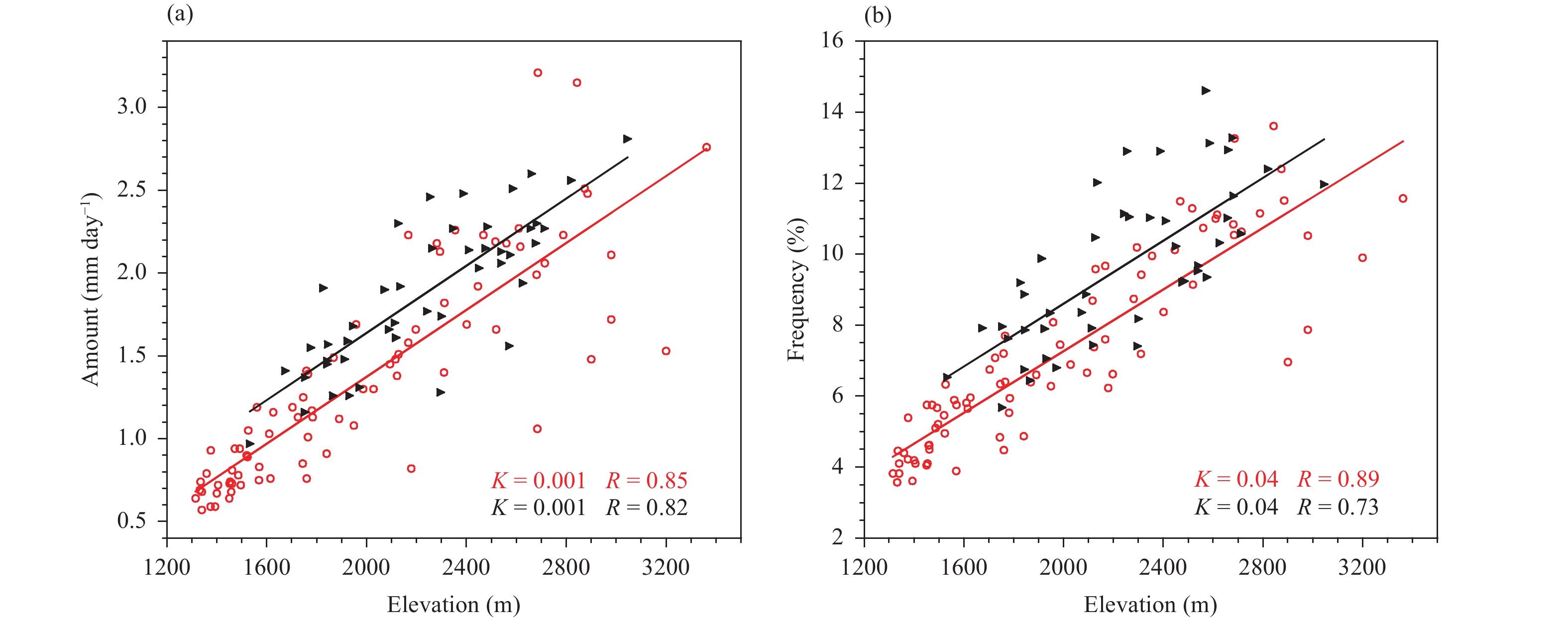
The correlations between the summer mean rainfall amount (frequency) and gauge elevations over the two slopes are first studied (Fig. 6). With increased gauge elevation, the rainfall amount has an obviously increasing trend over the two slopes (Fig. 6a). The linear fit shows that the rainfall amount is positively correlated with the elevations of the stations over the two slopes. The linear correlation coefficients (R) are 0.85 and 0.82 for the two slopes, both of which passed the significance test at the 99% confidence level. The rates of increase (K) are 0.001 over the two slopes. Similarly, consistent trends are observed for the rainfall frequency (Fig. 6b). There is an increase in the rainfall frequency concurrent with the increasing elevations over the two slopes.
|
| Figure 6 Relationships between the elevation and rainfall (a) amount and (b) frequency in the M_NE (red) and M_SE (black) regions. |
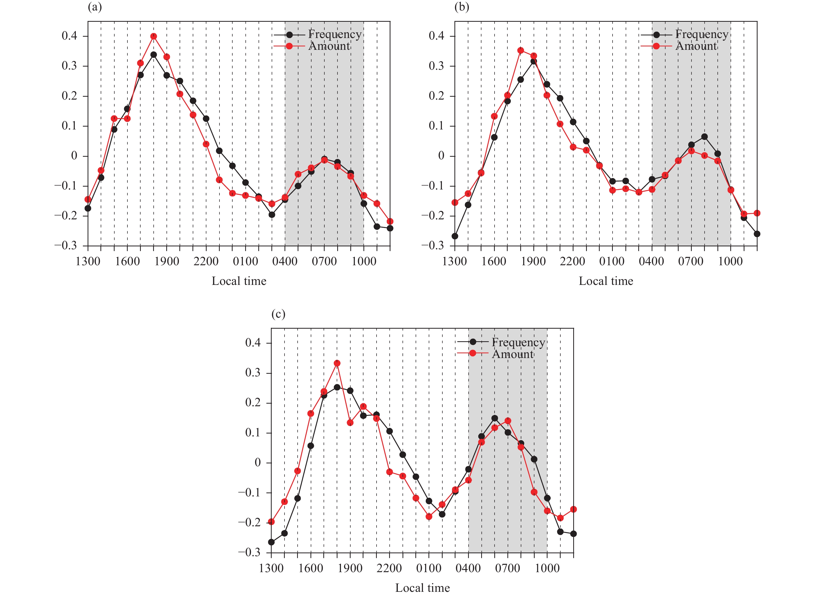
For a preliminary understanding of the spatial variations of the diurnal cycle in rainfall over the northeastern and southeastern slopes of the Qilian Mountains, we classified the stations into three elevation ranges. Then, we analyzed the mean diurnal cycles of the stations with gauge elevations in each range over the northeastern slope, as shown in Fig. 7. The diurnal cycle of the rainfall has a late-afternoon peak on the mountain top (in the M_M region), as mentioned previously (Fig. 4d). This late-afternoon peak still exists on the northeastern slope for elevations greater than 2500 m. Additionally, an obvious feature is that an early-morning peak (0700 LST) appears, as shown in Fig. 7a. With a decreased elevation, the early-morning peak becomes stronger over the mountain side (Fig. 7b). Furthermore, the early-morning peak becomes stronger when the elevation drops below 1500 m and can even match the late-afternoon peak (Fig. 7c). Similarly, consistent phenomena are observed for the southeastern slope (figure omitted).
|
| Figure 7 Mean standardized diurnal cycle of the summer precipitation amount (red lines) and frequency (black lines) for (a) elevations ≥ 2500 m, (b) elevations between 1500 and 2500 m, and (c) elevations < 1500 m. The gray shadow indicates the early-morning period. |
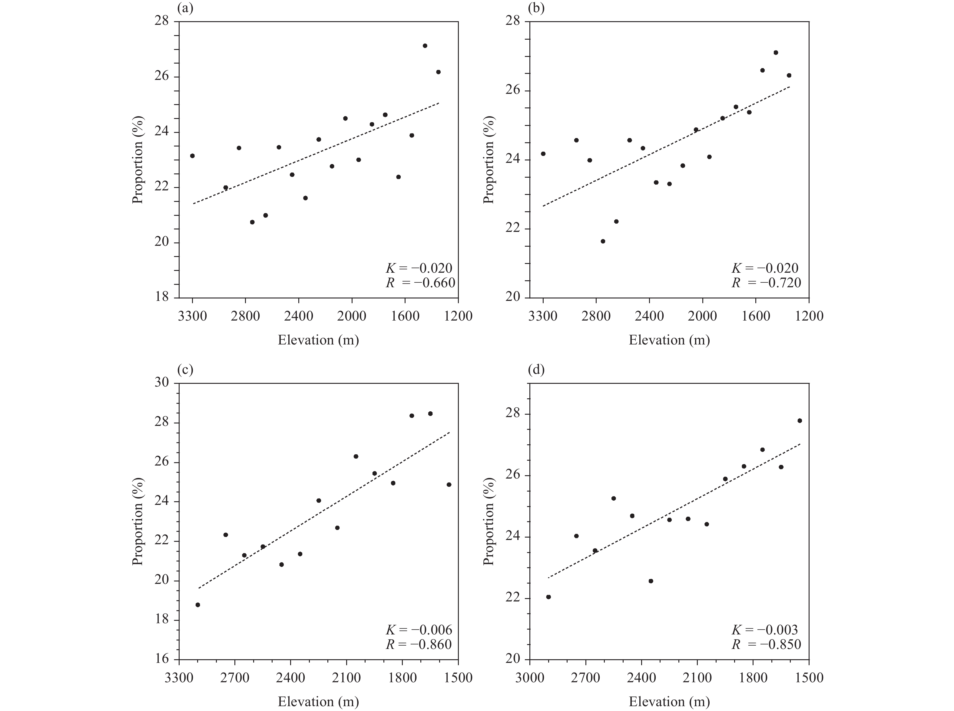
To quantitatively analyze the relationship between the gauge elevation and the early-morning peak over the northeastern and southeastern slopes, we studied the correlation between the proportion of rainfall during the early-morning period to the total daily rainfall and the gauge elevation for each slope, as shown in Fig. 8. Our results show that the proportion of the rainfall amount (frequency) occurring during the early-morning period is negatively correlated with the elevation in both the M_NE (northeastern slopes) and M_SE (southeastern slopes) regions. With decreased elevation, the proportions of rainfall amounts and frequencies during the early-morning period gradually increase with linear correlation coefficients of –0.66 (–0.86) and –0.72 (–0.85) in the M_NE (M_SE) region, which passed the significance test at the 99% confidence level.
|
| Figure 8 Relationships between the elevation and the proportion of early-morning rainfall (a) amount and (b) frequency in the M_NE region. The points represent the average elevation values of stations within each 100 m. (c, d) are the same as (a, b), but for the M_SE region. |
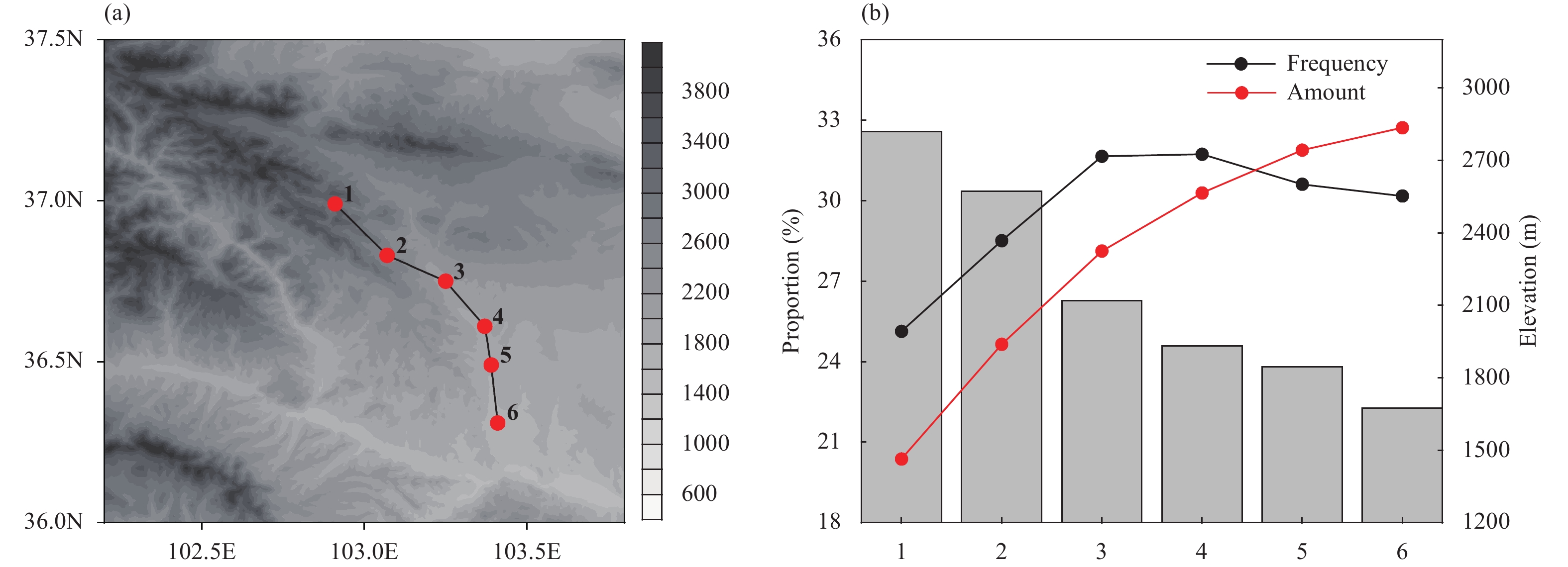
To further explain the relationship between the location of stations and the diurnal variations of rainfall, we selected a longitudinal section with six stations over the southeastern slope, as shown in Fig. 9a. The locations of the six stations represent different terrain elevations. From station 1 to 6, the elevation of terrain decreased, and the elevations of the six stations also decreased from 2820 to 1674 m (Fig. 9b), respectively. Along the longitudinal section, the proportions of early-morning rainfall amount gradually increase from 20.41% to 32.49% with the decreasing elevation. For rainfall frequency, the proportions in the first four stations gradually increase along the section. Similarly, consistent phenomena are observed over the northeastern slope (figure omitted). Our results further demonstrate that the station with a lower elevation has larger proportion of early-morning rainfall than that of the station with a higher elevation.
|
| Figure 9 (a) The location of a longitudinal section over the M_SE region. The six stations are labeled by identification codes (1–6). (b) The proportions of early-morning rainfall (red for amount and black for frequency) for the six stations (lefty-axis; %). Gray bars along the right y-axis present the elevations of the stations (in m). |
Figure 10 shows the increment of rainfall frequency between higher elevations and lower elevations decomposed by duration and diurnal phase over the northeastern and southeastern slopes. Over the two slopes, the increment of rainfall frequency at different durations and diurnal phases is obviously uneven. Over the northeastern slope (Fig. 10a), the increment during 1300–2200 LST is larger than during the other diurnal phases, which corresponds to the proportions of early-morning rainfall frequency to the total rainfall over the higher elevations to be smaller than that of the lower elevations. The maximum increment is contributed by rainfall events with durations between 1 and 4 h and diurnal peaks between 1300 and 1700 LST, which indicates that the most likely type of rainfall at high elevations, compared to lower elevations, is rainfall events with short durations occurring in the afternoon. In addition, the secondary large region of increment is located over 1600–2200 LST with the duration of 4–8 h. Over the southeastern slope, a similar phenomenon is observed (Fig. 10b). The increment during 1300–2000 LST is larger than the other diurnal phases, and there is a large value region with the duration of no longer than 6 h, which occurs in the afternoon (centered at 1500 LST).

|
| Figure 10 The increment of rainfall frequency with different durations and diurnal phases between (a) elevation ≥ 2500 m and elevation < 1500 m over the M_NE region and (b) elevation ≥ 2500 m and elevation < 2000 m over the M_SE region. |
Based on the summer hourly rain-gauge data during 2009–16, the overall features and regional differences in the diurnal variations of rainfall are identified over the Qilian Mountains in the arid/semi-arid region of China, and the influences of the gauge elevations on the diurnal variations in rainfall are also revealed. The major results are summarized as follows.
(1) The spatial features of rainfall are highly correlated to gauge elevations. The stations in the mountainous areas receive more rainfall than the surrounding stations. Over the northeastern and southeastern slopes, the summer total rainfall amounts and frequencies increase with increasing elevations. The largest rainfall amounts are located over the middle and eastern sections of the Qilian Mountains, and the regions also have high rainfall frequencies and intensities.
(2) The diurnal variations of rainfall have distinct regional features over the Qilian Mountains. Four regions with different diurnal variations have been identified. Over the mountain tops, the diurnal maximum rainfall occurs in the late afternoon. Over the northeastern and southeastern slopes, the major peak occurs in the late afternoon while a secondary peak appears in the early morning. Across the plains surrounding the Qilian Mountains, a weak early-morning maximum of rainfall is found. The Qinghai Lake shows a single nocturnal peak. The diurnal features of rainfall amount and frequency are found to be more coherent than rainfall intensity.
(3) Over the northeastern and southeastern slopes, the strengths of the late-afternoon and early-morning peaks in rainfall frequencies are closely related to rainfall events with different durations. Over the two slopes, the rainfall events with duration shorter than 6 h are characterized by the late-afternoon peak, while the rainfall events longer than 12 h have diurnal maximum rainfall in the early-morning period. When the duration is between 7 and 12 h, the rainfall in the late-afternoon period is greater than that in the early-morning period over the northeastern slope, whereas the rainfall in late-afternoon period is less than that in early-morning period over the southeastern slope.
(4) The gauge elevation has a significant impact on the diurnal variations of rainfall over the northeastern and southeastern slopes. With decreased elevation, the proportion of the rainfall amount (frequency) that occurs during early-morning periods increase over the two slopes. That is, the mountain top has a significant late-afternoon peak, and over the slopes, the secondary early-morning peak appears and gradually increases with decreasing elevations, then the early-morning peak dominates across the plains with low elevations.
(5) Over the northeastern and southeastern slopes, the maximum increment of the rainfall frequency between the higher elevation areas and the lower elevation areas is caused by rainfall events occurring in the afternoon. These rainfall events tend to have short durations.
Our results indicate that the features of diurnal variation over the Qilian Mountains are significantly affected by the topography. Over the northeastern and southeastern slopes, we mainly analyzed the slopes’ similar features of diurnal variation. It is noteworthy that there are some differences in the diurnal variations of rainfall between the two slopes. The relationship between the diurnal rainfall and duration is obviously different in the two slopes. The late-afternoon peak over the southeastern slope appears earlier than the northeastern slope. The proportion of early-morning rainfall amounts (frequencies) over the southeastern slope has a stronger relationship with the gauge elevation than that over the northeastern slope. With a decrease in elevation, the proportion of early-morning rainfall amounts (frequencies) in the southeastern slope increases faster than the northeastern slope. These differences between the two slopes imply that despite the elevation, some other topography related factors, such as orographic slope and orientation, should also be considered when investigating the influence of topography on the diurnal variations of rainfall over the Qilian Mountains. The mechanism of rainfall feature between the different orientations of slope will be explored in further investigation. Besides, the influence of the East Asian summer monsoon and the dynamic and thermal effects of the Tibetan Plateau on the rainfall feature over the slopes of the Qilian Mountains will be explored and compared in future studies.
Acknowledgments.The authors wish to thank the Edi-tor and the anonymous reviewers for their constructive comments and valuable suggestions.
| Barros, A. P., and T. J. Lang, 2003: Monitoring the monsoon in the Himalayas: Observations in central Nepal, June 2001. Mon. Wea. Rev., 131, 1408–1427. DOI:10.1175/1520-0493(2003)131<1408:MTMITH>2.0.CO;2 |
| Basist, A., G. D. Bell, and V. Meentemeyer, 1994: Statistical relationships between topography and precipitation patterns. J. Climate, 7, 1305–1315. DOI:10.1175/1520-0442(1994)007<1305:SRBTAP>2.0.CO;2 |
| Bonacina, L. C. W., R. M. Poulter, S. E. Ashmore, et al., 1945: Orographic rainfall and its place in the hydrology of the globe. Quart. J. Roy. Meteor. Soc., 71, 41–55. DOI:10.1002/qj.49707130705 |
| Burbank, D. W., A. E. Blythe, J. Putkonen, et al., 2003: Decoupling of erosion and precipitation in the Himalayas. Nature, 426, 652–655. DOI:10.1038/nature02187 |
| Chen, H. M., W. H. Yuan, J. Li, et al., 2012: A possible cause for different diurnal variations of warm season rainfall as shown in station observations and TRMM 3B42 data over the southeastern Tibetan Plateau. Adv. Atmos. Sci., 29, 193–200. DOI:10.1007/s00376-011-0218-1 |
| Ding, X. R., 2003: Water increasing effect of mountains and its value of water resources. J. Mountain Res., 21, 681–685. DOI:10.3969/j.issn.1008-2786.2003.06.007 |
| Fujinami H., S. Nomura, and T. Yasunari, 2005: Characteristics of diurnal variations in convection and precipitation over the southern Tibetan Plateau during summer. SOLA, 1, 49–52. DOI:10.2151/sola.2005-014 |
| Gou, X., F. Chen, M. Yang, et al., 2005: Climatic response of thick leaf spruce (Piceacrassifolia) tree-ring width at different elevations over Qilian Mountains, northwestern China. J. Arid Environ., 61, 513–524. DOI:10.1016/j.jaridenv.2004.09.011 |
| Jia, W. X., Y. S. Zhang, and Z. X. Li, 2014: Spatial and temporal change of rainfall extremes in Qilian Mountains and Hexi Corridor in recent 50 years. Scientia Geogra. Sinica, 34, 1002–1009. DOI:10.11821/xb201205006 |
| Li, J., T. R. Chen, and N. N. Li, 2017: Diurnal variation of summer precipitation across the central Tianshan Mountains. J. Appl. Meteor. Climatol., 56, 1537–1550. DOI:10.1175/JAMC-D-16-0265.1 |
| Li, X., Q. Zhang, and C. Y. Xu, 2014: Assessing the performance of satellite-based precipitation products and its dependence on topography over Poyang Lake basin. Theor. Appl. Climatol., 115, 713–729. DOI:10.1007/s00704-013-0917-x |
| Li, Y. Y., Q. Zhang, X. Xu, et al., 2010: Relationship between precipitation and terrain over the Qilian Mountains and their ambient areas. J. Glaciol. Geocryol., 32, 52–61. |
| Liang, H., J. M. Liu, and Y. Chen, 2010: Characteristics and cause of diurnal variation of precipitable water vapor derived from ground-based GPS in Qilian Mountains in summer. Plateau Meteor., 29, 726–736. |
| Liu, X. M., M. J. Zhang, S. J. Wang, et al., 2016: Diurnal variation of summer precipitation and its influencing factors over the Qilian Mountains during 2008–2014. Acta Geogra. Sinica, 71, 754–767. DOI:10.11821/dlxb201605005 |
| Prudhomme, C., and D. W. Reed, 1999: Mapping extreme rainfall in a mountainous region using geostatistical techniques: A case study in Scotland. Int. J. Climatol., 19, 1337–1356. DOI:10.1002/(SICI)1097-0088(199910)19:12<1337:AID-JOC421>3.0.CO;2-G |
| Qian, J. H., A. W. Robertson, and V. Moron, 2010: Interactions among ENSO, the monsoon, and diurnal cycle in rainfall variability over Java, Indonesia. J. Atmos. Sci., 67, 3509–3524. DOI:10.1175/2010JAS3348.1 |
| Singh, P., and K. Nakamura, 2009: Diurnal variation in summer precipitation over the central Tibetan Plateau. J. Geophys. Res. Atmos., 114, D20107. DOI:10.1029/2009JD011788 |
| Weisse, A. K., and P. Bois, 2001: Topographic effects on statisti-cal characteristics of heavy rainfall and mapping in the French Alps. J. Appl. Meteor., 40, 720–740. DOI:10.1175/1520-0450(2001)040<0720:TEOSCO>2.0.CO;2 |
| Yin, X. Z., Q. Zhang, Q. Y. Xu, et al., 2009: Characteristics of climate change in Qilian Mountains region in recent 50 years. Plateau Meteor., 28, 85–90. |
| Yu, R. C., and J. Li, 2016: Regional characteristics of diurnal peak phases of precipitation over contiguous China. Acta Meteor. Sinica, 74, 18–30. DOI:10.11676/qxxb2016.011 |
| Yu, R. C., Y. P. Xu, T. J. Zhou, et al., 2007: Relation between rainfall duration and diurnal variation in the warm season precipitation over central eastern China. Geophys. Res. Lett., 34, L13703. DOI:10.1029/2007GL030315 |
| Zhang, J., and D. L. Li, 2004: Analysis on distribution characteristics of rainfall over the Qilian Mountain and Heihe Valley. Plateau Meteor., 23, 81–88. DOI:10.3321/j.issn:1000-0534.2004.01.012 |
| Zhang, L., Q. Zhang, J. Y. Feng, et al., 2014: A study of atmospheric water cycle over the Qilian Mountains (I): Variation of annual water vapor transport. J. Glaciol. Geocryol., 36, 1079–1091. DOI:10.7522/j.issn.1000-0240.2014.0130 |
| Zhou, T. J., R. C. Yu, H. M. Chen, et al., 2008: Summer precipitation frequency, intensity, and diurnal cycle over China: A comparison of satellite data with raingauge observations. J. Climate, 21, 3997–4010. DOI:10.1175/2008JCLI2028.1 |
 2019, Vol. 33


