The Chinese Meteorological Society
Article Information
- YANG Xianyu, LÜ Yaqiong, MA Yaoming, WEN Jun. 2015.
- Summertime Thermally-Induced Circulations over the Lake Nam Co Region of the Tibetan Plateau
- J. Meteor. Res., 28(2): 305-314
- http://dx.doi.org/10.1007/s13351-015-4024-z
Article History
- Received May 12, 2014;
- in final December 4, 2014
2 School of Engineering, University of California, Merced, CA 95344, USA;
3 Institute of Tibetan Plateau Research, Chinese Academy of Sciences, Beijing 100085, China
Thermally-induced circulations, such as lakebreezes(LBs)driven by the uneven heating of l and and lake, are important in changing local weather and boundary layer meteorology. For instance, LBs cangenerate snow storms(Peace and Sykes, 1966; Braham and Dungey, 1995; Steenburgh et al., 2000), developLB fronts(Daggupaty, 2001), affect the movement oftrace particles(Harris and Kotamarthi, 2005), transportphotochemical pollutants(Kitada et al., 1986;McKendry et al., 1998), and influence ozone concentrations(Hanna and Chang, 1995). Unlike the LBcharacteristics and effects in the Great Lakes and LakeMichigan(Lyons, 1972; Keen and Lyons, 1978), thosein other regions, such as Lake Nam Co over the TibetanPlateau(TP), have not been thoroughly investigated.
The TP is located in central Asia and is the highest and most extensive plateau in the world. Previousstudies have indicated that the TP has profoundthermal and dynamical impacts on atmospheric circulationin the Northern Hemisphere as well as on theglobal climate(Manabe and Broccoli, 1990; Yanai et al., 1992; Kutzbach et al., 1993; Zou et al., 2014). Inaddition, the TP is among the areas most sensitiveto global climate change(Liu and Chen, 2000). LakeNam Co is the largest lake in the central TP and is located on the northern foot of the NyainqˆentanglhaRange. The Lake Nam Co region includes a heterogeneousl and cover typical in the TP(e.g., lake, meadow, marsh, glacier, permafrost, or crops). Uneven heatingover these l and cover patches can cause multiplethermally-induced circulations, particularly LBs and mountain-valley winds, over the Lake Nam Co region.The interactions between these circulations can considerablyalter the local wind systems, resulting in variousmeteorological consequences(McGowan and Sturman, 1996; Bischoff-Gauβ et al., 2006). Underst and ingthe interactions between the LBs and mountainvalleywinds over Lake Nam Co is fundamentally importantin the evaluation of the impact of the localwind system on weather and climate. Furthermore, analyzing the characteristics of local wind systems canprovide valuable information about the relationshipbetween Lake Nam Co and these local wind systems, which can be used to estimate the effect of evaporativewater vapor from Lake Nam Co on the local atmosphericwater vapor(Xu et al., 2011), boundarylayer convection(Zhou et al., 2011), aerosol deposition(Cong et al., 2010; Wang et al., 2014), and pollen and trace gas transport(Cong et al., 2010; Lu et al., 2010; Xia et al., 2011).
This study aims to(1)evaluate the performanceof the fifth-generation Pennsylvania State University/National Center for Atmospheric Research(PSU/NCAR)Mesoscale Model(MM5)in simulating2-m air temperature and wind fields, and (2)investigatethe interactions between two thermally-inducedcirculations, i.e., LBs and mountain-valley winds, atLake Nam Co using the MM5. Section 2 presents thedata collected from the field observation sites and thenumerical experiment design. An evaluation of theperformance of MM5, the simulation results, and relateddiscussion are described in Section 3. The conclusionis given in Section 4.2. Study area and numerical experiment design2.1 Study area
Lake Nam Co is the largest lake(1920 km2)in thecentral TP(Guan et al., 1984). It is located 4718 mabove sea level and approximately 120 km northwest ofLhasa, Tibet(Fig. 1). The terrain of this area is complex.The Nyainqˆentanglha Range lies southeast ofthe lake. With its peak at 7111 m and average heightbetween 5300 and 6300 m, this mountain range physicallyobstructs northwesterlies or southeasterlies. Thevegetation types surrounding Lake Nam Co includegrass, wooden tundra, mixed shrubs and grass, baresparse vegetation, and crop grass mosaic, as definedby the USGS(United States Geological Survey)25vegetation categories. Three synoptic systems controlthis area: the South Asian anticyclone, which controlsthe 100-hPa upper layer; the subtropical high-pressuresystem, which is usually divided into eastern and westernparts by the TP after mid July; and the southeastwarm and wet airflow, which appears during themonsoon season(Qiao and Zhang, 1994). With themonsoon precipitation, the Lake Nam Co region experiencesa moist and cool climate during summer. Theaverage annual precipitation in the Lake Nam Co regionis 281.8 mm, and the average annual temperatureis 0℃(You et al., 2007). During our study period, theaverage sunrise time in the Lake Nam Co region was0700 Beijing Time(BT), and the average sunset timewas 2100 BT.
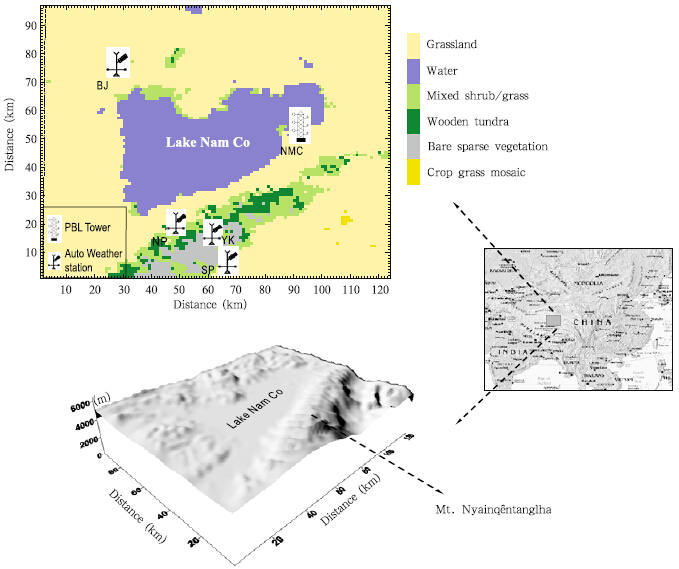 |
| Fig. 1. Geographic map of the Lake Nam Co region showing l and use, topography, and the locations of the five observation sites. |
In 2005, five observation sites were established inthe study area(Fig. 1)by the Institute of TibetanPlateau Research, Chinese Academy of Sciences. TheNam Co(NMC)site is a comprehensive site equippedwith a variety of observation facilities, including aneddy covariance flux and boundary layer tower, atmospherechemistry sensors, and hydrological stations.The meteorological data for 2-m air temperature and 10-m wind from the boundary layer tower were usedin this study. The other four sites, Baoji(BJ), NorthSlope(NP), South Slope(SP), and Yakou(YK))wereinstalled with auto weather stations(BJ and NP useda CR1000 data logger, SP and YK used a CR10X datalogger, from the Campbell Scientific), and the meteorologicaldata collected from these sites are 2-m airtemperature and 2.4-m wind observations.2.2 Model and numerical experiment design
Numerical models play an important role inweather simulation and forecasting(Wang and Yu, 2013; Wu et al., 2014; Zhou et al., 2014). The MM5 isa regional mesoscale model developed and maintainedby PSU and NCAR. The application of high-resolutionmesoscale models is useful in operational weather forecast, particularly in areas where topography, l and surfaceproperties, and heterogeneity modulate synopticweather to cause localized weather phenomena. Inthis study, MM5 was used to explore the influenceof Lake Nam Co on the local wind system. In addition, the performance of the MM5 was evaluated inan area with complex terrain and vegetation types toprovide a basis for improving the model. The MM5is a nested-grid primitive-equation model that usesa terrain-following sigma vertical coordinate(Dudhia, 1993). Three nested domains(one-way nest)were definedfor the purposes of this study. Their resolutionsare 9, 3, and 1 km for the outer to inner domains, respectively, and the grid cells for these resolutions are60×80, 73×91, and 97×124, respectively.
We used the 1◦×1◦ NCEP/FNL analysis data asthe boundary and initial conditions. Two 48-h simulationswere carried out between 0800 BT 4 and 0800BT 6 July 2006, under a fair synoptic background favorablefor local thermally-induced circulations. Thetwo simulations were the control experiment(LAKE), in which the original l and surface was used, and thesensitive experiment(LAND), in which all the lakegrid cells were replaced by grassl and similar to theterrain that surrounds the lake. The comparison betweenthe two experiments aimed to emphasize thelake effects on the local wind system. In the vertical, 23 unevenly spaced sigma levels were employed. The model includes various physical parameterizations forradiative transfer, cloud microphysics, cumulus convection, boundary layer turbulence, and l and surfaceexchange processes. The physics schemes employed forthis experiment were Grell cumulus parameterization(Grell et al., 1991), a medium-range forecast planetaryboundary layer scheme(Hong and Pan, 1996), a simple ice microphysics scheme, a cloud radiationscheme(Dudhia, 1989), and a simple multilayer soilmodel. The parameterization scheme for the sensibleheat flux(SH)used in the MM5 is the verticaldiffusion scheme, which is integrated with the MRF(Medium Range Forecast)planetary boundary layerscheme. The model outputs, which are generated everyhour, are obtained for the following analysis.3. Results3.1 Model evaluation
Figure 2 shows that the MM5 simulated the 2-mair temperature(T2)better than the wind speed atthe five sites. The root-mean-square error(RMSE)ofT2 at the five sites was between 1.25 and 2.2℃. TheYK site showed the smallest T2 RMSE, whereas theBJ site showed the largest T2 RMSE. Although themodel captured the diurnal cycle of T2, it underesti-mated the nighttime T2 in all the five sites; this underestimationcould affect the wind field simulation.The MM5 overestimated the overall wind speeds of allthe five sites, with the RMSE ranging from 2.3 to 4.7m s−1. The simulation was more accurate on the secondday(5 July)than on the first day(4 July). TheRMSE of the wind speed was reduced by 28% on thesecond day.
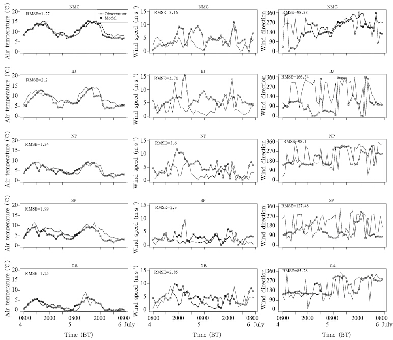 |
| Fig. 2. Modeled and observed 2-m air temperature, wind speed, and wind direction for the five observation sites from0800 BT 4 to 0800 BT 6 July 2006. All simulated winds are the instantaneous 10-m wind speed and direction. Theobserved wind at the NMC site is the instantaneous 10-m wind speed and direction, whereas at the BJ, NP, SP, and YKsites, the observed wind is the instantaneous 2.4-m wind speed and direction. |
Regarding the wind direction, the observationsshowed a significant hourly variation that was difficultfor the model to capture. At the SP site, the observedwind direction regularly shifted between easterly(90◦) and westerly(270◦)from 0800 to 2000 BT4 July, whereas the model showed a gradual changefrom 90◦ to 270◦ over the same time period. At theYK site, the observed wind direction shifted regularlybetween southeasterly(90◦–180◦) and northwesterly(270◦–360◦)from 0800 to 2000 BT 5 July, whereasthe simulated wind direction gradually changed fromnorthwesterly to southeasterly. As with the windspeed, the wind direction simulation was better on thesecond day(5 July)than on the first day(4 July). Themodel captured the wind direction well from 0900 to1300 BT 5 July at the NMC, BJ, and NP sites. Atthe NMC site on 5 July, the simulated diurnal winddirection was reasonably accurate, but the nocturnalsimulation for southeasterly(90◦–180◦, from l and tolake)was 4 h earlier than that in the observations, which is likely because the simulated SH over the l and decreased too rapidly near sunset.
There are two possible reasons for the poor windfield simulation. First, the wind field extracted fromthe model is the instantaneous 10-m wind(the modeldoes not output the 2-m wind field), whereas the observedwind is the instantaneous 2.4-m wind for theBJ, NP, SP, and YK sites and is only the instantaneous10-m wind for the NMC site. This mismatch couldaccount for some of the overestimated wind speeds, because the 10-m wind speed is typically higher thanthe 2-m wind speed due to the lower surface drag.Second, the site-level observation and the 1-km resolutiongrid cells may not align perfectly, which wouldmake the comparison inappropriate. We extracted thesimulation from the grid cell that was nearest to eachobservation site. The large variation in the observedwind direction may be because of the widely varyinglocal topography, which means that the topography ofthe grid cell is significantly different from that of thesite. With a 1-km resolution, the model may neglecta certain topography that could affect wind direction, particularly at the three more mountainous sites.
Although the wind direction simulations showlarge biases, the simulations still reflect the wind directionchanges of the lake/l and breezes. In Fig. 3, theLB is represented by blue arrows and the l and breezeby red for the NMC and BJ sites from 0800 BT 5 to0800 BT 6 July. At the NMC site, the onset of theLB in both the simulation and the observation wasaround 1200–1300 BT, although the simulated winddirection changed back to l and breeze earlier than didthe observation. At the BJ site, the onset of the LB inthe simulation(1500 BT)was earlier than that in theobservation(1700 BT). The observed wind directionfrom 1700 to 2100 BT varied between the lake and the l and breeze, whereas the model showed a consistentLB. Between 2200 and 0000 BT, the l and breezeprevailed in both the simulation and the observation.Moreover, the wind direction changed again to LBin both the simulation and observation from 0200 to0700 BT, which was likely because the coupling of twosoutherlies(hill to valley wind at the north slope and l and to lake wind at the south shore)overwhelmed thenighttime l and breeze at the BJ site. However, given that the model simulated a poor wind direction atnight, this conclusion must be verified with additionalobservations at the north shore.
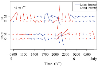 |
| Fig. 3. Modeled and observed wind vectors at the NMC and BJ sites from 0800 BT 5 to 0800 BT 6 July 2006. The letter O indicates observed values and M indicates simulation values. The LB is indicated in blue and the l and breeze is in red. |
Figure 4 shows the 10-m surface wind vector at1400 and 2000 BT for the innermost domain. At 1400BT, a clear divergence wind pattern in the central partof the lake suggested that an obvious LB was well established(Fig. 4a)in the LAKE simulation, whereasthe LAND simulation was dominated by a southwesterly(Fig. 4b). At 1400 BT, the wind velocity over thelake area in the LAKE simulation(Fig. 4a)shouldhave been greater than that in the LAND simulation(Fig. 4b)because of the small momentum roughnesslength of the lake surface, but the thermally-inducedLB was dominant and overwhelmed such a wind velocityenhancement from the small lake momentumroughness length. The mountain-valley winds wereobserved in both the LAKE and LAND simulations.However, the north slope wind in the LAKE simulationwas stronger(0.3 m s−1 higher on average)thanthat in the LAND simulation, most likely because theLB penetrated inl and and enhanced the on-slope windon the north slope. Thus, the lake influenced not onlythe LB but also the vicinity of the up-slope winds.
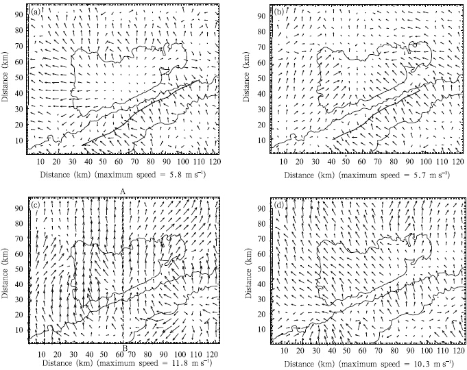 |
| Fig. 4. 10-m wind vectors for the 1-km domain at(a, b)1400 BT and (c, d)2000 BT 4 July 2006 from the LAKE and LAND simulations, respectively. The thick line in(a) and (b)is the wind shear line. The solid lines show the boundary of Lake Nam Co and Mt. Nyainqentanglha. The dotted line AB in(c)shows the cross-section along which the simulated wind vectors displayed in Fig. 8 are obtained. |
Over the mountainous regions, a clear convergencezone was observed(near the solid line in Fig. 4a)because of the opposite wind directions on thenorth and south slopes. The area controlled by thewind shear zone could potentially generate strong convectiveclouds and precipitation. The MODIS imageobtained on 4 July(Fig. 5)showed strong convection over the eastern mountain ridge during this time, which also confirmed that no convection occurred overLake Nam Co as simulated by the MM5. When thelake was replaced(Fig. 4b), most areas were dominatedby southerlies, and the up-slope northerlies werevery weak. At 2000 BT, a strong southerly wind prevailedin most of the areas under the LAKE simulation(Fig. 4c), whereas only a weak down-slope southerlywas observed in the LAND simulation(Fig. 4d). Thestronger southerly in the LAKE simulation than inthe LAND simulation at 2000 BT could have been becauseof the southerly l and breeze combined with thedown-slope southerly(Li et al., 2009). For the LAKEsimulation, the wind velocity was greater at 2000 BT(Fig. 4c)than at 1400 BT(Fig. 4a), which was likelybecause of the dominant strong background wind velocityoverwhelming the weak thermally-induced effectat night. In general, the surface wind is weakin the morning and strong in the late afternoon orevening over the TP. At 2000 BT, the wind enhancementin the LAKE simulation(Fig. 4c)was because ofthe dominant strong background wind velocity, whilethe thermally-induced circulation was weak for a smalltemperature difference between the lake and the l and (mountain).
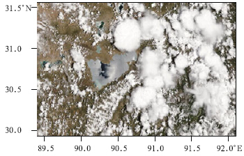 |
| Fig. 5. The MODIS image for the Lake Nam Co region at 1250 BT 4 July 2006. |
The large temperature gradient between the lake and the l and was the driving force of the LB in theLAKE simulation. For the LAKE simulation, the 2-m air temperature over the lake was 12℃, which wasnearly 5℃ lower than that over the surrounding l and (Fig. 6a). By comparison, the original lake area inthe LAND simulation(Fig. 6b)showed a higher temperature(20℃), thereby generating a southerly. Theexistence of the lake reduced not only the air temperaturebut also the SH over the lake. In the LAKEexperiment(Fig. 7a), the SH over the lake was 100W m−2, which is roughly 1/3 of that over the l and (300 W m−2). Over the mountainous region, the SHreached a maximum value of over 600 W m−2. Sucha remarkable difference is important in the formationof thermal circulation(Segal and Arritt, 1992). In theLAND simulation(Fig. 7b), without the lake, the averageSH of the entire area was larger than that in theLAKE simulation by 100 W m−2.
 |
| Fig. 6. Distributions of 2-m air temperature at 1400 BT 4 July 2006 for the(a)LAKE and (b)LAND simulations.The contour interval is 4℃, and the L and H markers on the plots indicate low and high values that do not fit into the contour level. |
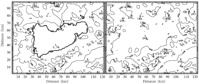 |
| Fig. 7. As in Fig. 6, but for SH contour. The contour interval is 150 W m−2. |
Figure 8 shows cross-sections of the wind vector and potential temperature at 1400 BT along line ABin Fig. 4c for the LAKE(Fig. 8a) and LAND(Fig. 8b)simulations. The downward flow controlled thelayers lower than 7500 m above the lake at 1400 BT, when the LB was well established, and the LANDexperiment showed an upward vertical flow becauseof the well-mixed turbulence. Over the convergencezone of the mountain, the air reached up to approximately8500 m because of the coupling of LB and winds, whereas such a flow was reduced to nearly 1000m in the LAND simulation when the flow was causedby the mountain-valley winds alone. In the LAKEsimulation, the potential temperature was 2℃ lowerin the boundary layer than that in the LAND simulation, but the two values exhibited no difference in theupper layer.
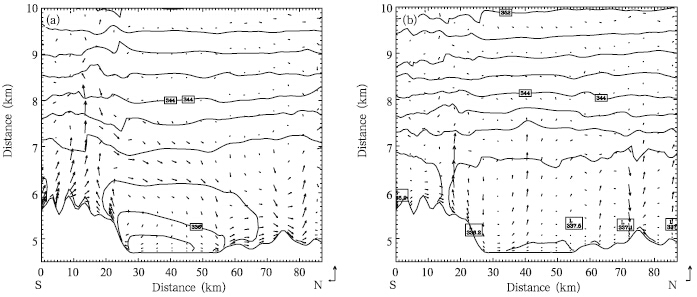 |
| Fig. 8. Vertical cross-sections of potential temperature and wind vector in the north-south direction through line AB(Fig. 4c; A: 31.0◦N, 90.5◦E and B: 30.1◦N, 90.5◦E)at 1400 BT 4 July 2006, for the(a)LAKE and (b)LAND simulations.The contour lines denote potential temperature with a 2-K interval. Rectangles with the letter L in(b)indicates thelow value of potential temperature that does not fit into the contour level. |
The existence of the lake strengthened themountain-valley wind, especially over the north slope.On 4 and 5 July, at the NP site, a higher mean windspeed was seen at the SP site in both the observation(over 1.2 m s−1) and the simulation(over 1.8m s−1). This finding could be because of the couplingof the northerly LB at the south shore and theuphill wind at the north slope. The vertical windprofile clearly showed that the wind speed and theupward flow were much stronger with the lake(Fig. 8a)than without the lake(Fig. 8b), which is likely because the relatively cool lake surface enhanced theSH gradient between the mountain and the valley.4. Conclusions
Our study showed that the MM5 can be used tocapture the diurnal changes of the 2-m air temperatureover the Lake Nam Co region of the Tibetan Platean;however, the MM5 showed a large bias in wind fieldsimulation. Some of the bias may be because of thesurface wind field being more sensitive than the airtemperature to topographic changes. At a resolutionof 1 km, the model failed to capture certain variationsthat were seen in the observation. Therefore, a highresolution(e.g., hundreds of meters)numerical studyis required for highly heterogeneous regions. In addition, the simulation at the NMC site showed a l and breeze occurring 4 h earlier than in the observation, which suggested that simulated sensible heat flux overthe l and decreased too fast near sunset. Although themodel accurately captured the diurnal changes of the2-m air temperature, it underestimated the nighttime2-m air temperature at all five observation sites.
The numerical simulations showed that the lakeenhanced the north slope’s mountain-valley wind, and the mountain changed the offshore flow direction atthe north shore. The lake not only generated a lakebreeze but also increased the magnitude of the upslopewinds as well as winds over the north slope ofMt. Nyainqˆentanglha. The strong southerlies in theLAKE experiment could be attributed to the southerlyl and breeze combined with the down-slope southerly.In addition, a convergence zone over the north slopeof Mt. Nyainqˆentanglha and a strong upflow wereobserved during the daytime, which may have causedconvective cloud formation and precipitation on thenorth slope of the mountain. Further observations onthe north slope are needed to evaluate the effect ofthis convergence zone on the local precipitation.
| Bischoff-Gauβ, I., N. Kalthoff, and M. Fiebig-Wittmaack, 2006: The influence of a storage lake in the arid Elqui valley in Chile on local climate. Theor. Appl. Climatol., 85, 227-241. |
| Braham, R. R., and M. J. Dungey, 1995: Lake-effect snowfall over Lake Michigan. J. Appl. Meteor., 34, 1009-1019. |
| Cong, Z. Y., S. C. Kang, Y. L. Zhang, et al., 2010: Atmo-spheric wet deposition of trace elements to central Tibetan Plateau. Appl. Geochem., 25, 1415-1421. |
| Daggupaty, S. M., 2001: A case study of the simultane-ous development of multiple lake-breeze fronts with a boundary layer forecast model. J. Appl. Meteor., 40, 289-311. |
| Dudhia, J., 1989: Numerical study of convection ob-served during the winter monsoon experiment using a mesoscale two-dimensional model. J. Atmos. Sci., 46, 3077-3107. |
| Dudhia, J., 1993: A nonhydrostatic version of the Penn State NCAR mesoscale model-validation tests and simulation of an Atlantic cyclone and cold front. Mon. Wea. Rev., 121, 1493-1513. |
| Grell, G. A., Y. H. Kuo, and R. J. Pasch, 1991: Semiprog-nostic tests of cumulus parameterization schemes in the middle latitudes. Mon. Wea. Rev., 119, 5-31. |
| Guan Zhihua, Chen Chuanyou, Ou Yuxiong, et al., 1984: Rivers and Lakes in Tibet. Science Press, 176-182. (in Chinese) |
| Hanna, S. R., and J. C. Chang, 1995: Relations between meteorology and ozone in the Lake Michigan region. J. Appl. Meteor., 34, 670-678. |
| Harris, L., and V. R. Kotamarthi, 2005: The character-istics of the chicago lake breeze and its effects on trace particle transport: Results from an episodic event simulation. J. Appl. Meteor., 44, 1637-1654. |
| Hong, S. Y., and H. L. Pan, 1996: Nonlocal boundary layer vertical diffusion in a medium-range forecast model. Mon. Wea. Rev., 124, 2322-2339. |
| Keen, C. S., and W. A. Lyons, 1978: Lake-land breeze circulations on the western shore of Lake-Michigan. J. Appl. Meteor., 17, 1843-1855. |
| Kitada, T., K. Igarashi, and M. Owada, 1986: Numerical-analysis of air-pollution in a combined field of land sea breeze and mountain valley wind. J. Climate Appl. Meteor., 25, 767-784. |
| Kutzbach, J. E., W. L. Prell, and W. F. Ruddiman, 1993: Sensitivity of Eurasian climate to surface uplift of the Tibetan Plateau. J. Geology., 101, 177-190. |
| Li Ying, Li Yueqing, and Zhao Xingbing, 2009: Analyses of turbulent fluxes and micrometeorological characteristics in the surface layer at Litang of the eastern Tibetan Plateau. Acta Meteor. Sinica, 67, 417-425. (in Chinese) |
| Liu, X. D., and B. D. Chen, 2000: Climatic warming in the Tibetan Plateau during recent decades. Int. J. Climatol., 20, 1729-1742. |
| Lu, X. M., M. Herrmann, V. Mosbrugger, et al., 2010: Airborne pollen in the Nam Co basin and its im-plication for palaeoenvironmental reconstruction. Review of Palaeobotany and Palynology, 163, 104- 112. |
| Lyons, W. A., 1972: Forecasting Chicago Lake breeze. Bull. Amer. Meteor. Soc., 53, 87-&. |
| Manabe, S., and A. J. Broccoli, 1990: Mountains and arid climates of middle latitudes. Science, 247, 192-194. |
| McGowan, H. A., and A. P. Sturman, 1996: Interacting multi-scale wind systems within an alpine basin, Lake Tekapo, New Zealand. Meteor. Atmos. Phys., 58, 165-177. |
| McKendry, I. G., D. G. Steyn, R. M. Banta, et al., 1998: Daytime photochemical pollutant transport over a tributary valley lake in southwestern British Columbia. J. Appl. Meteor., 37, 393-404. |
| Peace, R. L., and R. B. Sykes, 1966: Mesoscale study of a lake effect snow storm. Mon. Wea. Rev., 94, 495-507. |
| Qiao Quanming and Zhang Yagao, 1994: Tibetan Plateau Synoptic Meteorology. China Meteorological Press, Beijing, 250. (in Chinese) |
| Segal, M., and R. W. Arritt, 1992: Nonclassical mesoscale circulations caused by surface sensible heat-flux gra-dients. Bull. Amer. Meteor. Soc., 73, 1593-1604. |
| Steenburgh, W. J., S. F. Halvorson, and D. J. Onton, 2000: Climatology of lake-effect snowstorms of the Great Salt Lake. Mon. Wea. Rev., 128, 709-727. |
| Wang Shuzhou, and Yu Entao, 2013: Simulation and projection of changes in rainy season precipitation over China using the WRF model. Acta Meteor. Sinica, 27, 577-584. |
| Wang Xin, Xu Baiqing, and Ming Jing, 2014: An overview of the studies on black carbon and mineral dust deposition in snow and ice cores in East Asia. J. Meteor. Res., 28, 354-370. |
| Wu Tongweng, Song Lianchun, Li Weiping, et al., 2014: An overview of bcc climate system model develop-ment and application for climate change studies. J. Meteor. Res., 28, 34-56. |
| Xia, X. G., X. M. Zong, Z. Y. Cong, et al., 2011: Baseline continental aerosol over the central Tibetan Plateau and a case study of aerosol transport from South Asia. Atmos. Environ., 45, 7370-7378. |
| Xu, Yanwei, Kang Shichang, Zhang Yulan, et al., 2011: A method for estimating the contribution of evapora-tive vapor from Nam Co to local atmospheric vapor based on stable isotopes of water bodies. Chin. Sci. Bull., 56, 1511-1517. |
| Yanai, M. H., C. F. Li, and Z. S. Song, 1992: Seasonal heating of the Tibetan Plateau and its effects on the evolution of the Asian summer monsoon. J. Meteor. Soc. Japan, 70, 319-351. |
| You Qinglong, Kang Shichang, Li Chaoliu, et al., 2007: Variation features of meteorological elements at Nam Co station, Tibetan Plateau. Meteor. Mon., 33, 54- 60. (in Chinese) |
| Zhou, D. G., R. Eigenmann, W. Babel, et al., 2011: The study of near-ground free convection conditions at Nam Co station on the Tibetan Plateau. Theor. Appl. Climatol., 105, 217-228. |
| Zhou Tianjun, Zou Liwei, Bo Wu, et al., 2014: Devel-opment of earth/climate system models in China: A review from the coupled model intercomparison project perspective. J. Meteor. Res., 28, 762-779. |
| Zou Han, Zhu Jinhua, Zhou L, et al., 2014: Validation and application of reanalysis temperature data over the Tibetan Plateau. J. Meteor. Res., 28, 139-149. |
 2015, Vol. 28


