 2014, Vol. 28
The Chinese Meteorological Society
Article Information
- WU Juxiu, WEI Ming, HANG Xin, ZHOU Jie, ZHANG Peichang, LI Nan. 2014.
- The First Observed Cloud Echoes and Microphysical Parameter Retrievals by China's 94-GHz Cloud Radar
- J. Meteor. Res., 28(3): 430-443
- http://dx.doi.org/10.1007/s13351-014-3083-x
Article History
- Received 2013-12-2;
- in final form 2014-3-13


2 Key Laboratory for Aerosol-Cloud-Precipitation of China Meteorological Administration, Nanjing University of Information Science & Technology, Nanjing 210044;
3 School of Electronic & Information Engineering, Nanjing University of Information Science & Technology, Nanjing 210044
Clouds are known to play a crucial role inthe earth’s radiation balance,weather forecasts,weather modification, and flight safety(Liou,1986).The main tools for detecting clouds are airborneinstruments,microwave radiometers,ceilometers,centimetre-wave radars,satellite observations,radiosondes, and millimetre-wave radars. Amongthese,the millimetre-wave cloud radar has provento be invaluable for observing non-precipitating and weakly precipitating clouds. The radar signal canpenetrate thick clouds to observe their internalstructures(Kropfli et al., 1995; Krofli and Kelly, 1996;Illingworth et al., 2007). A very important issue regardingthe use of radars at millimetre wavelengthsis signal attenuation due to clear air,clouds, and precipitation. The attenuation in terms of rain and drizzle intensity is presented and discussed in Lhermitte(2002). Usually,the wavelengths of millimetrewavecloud radars are 3 mm(at frequencies of approximately94 GHz) and 8 mm(at frequencies ofapproximately 35 GHz). The 94-GHz radars can detectsmaller cloud droplets and the early formation ofclouds. Additionally,94-GHz radars are fairly immuneto ground clutter that is detected through antenna sidelobes in a vertically pointing beam mode because oftheir short wavelength(Lhermitte,2002).
The Ka-b and radars in the United States havebeen developed since the 1950s. In the early 1970s,the American Air Force developed TPQ-11 radar(with 8.5-mm wavelength),which were combined withDoppler and dual polarization functions and used incloud physics research in the late 1980s(Sauvageot and Omar, 1987; Kropfli et al., 1995). The 35-GHz synthetic aperture radar and the 35-GHz/94-GHzmillimetre-wave cloud radar were developed in Americain 1992 and 1994,respectively(Zhong et al., 2009).These instruments can be used to detect and identifyice clouds,supercooled water, and the particle size distributionof clouds(Zhong et al., 2009). The first unmanned35-GHz cloud radar,which was developed in1996,was used for a cloud radiation test project. Itobserved the echo characteristics of non-precipitating and weakly precipitating clouds for a long term(Clothiaux et al., 1999). The American W-b and radars(3-mm wavelength)were introduced in the early 1980s and mainly used to study cloud and precipitationphysics in the late 1980s(Lhermitte,2002). Britaindeveloped the 94-GHz Galileo and 35-GHz CopernicusDoppler radars,which were used to invert cloud particlesizes and density in the 1990s(Hogan et al., 2000).In 1995,a polarimetric cloud radar with a wavelengthof 3 mm began operating at the GKSS Research Centre,Geesthacht,Germany. It has been used for casestudies of various stratiform,non-precipitating cloudsystems(Danne et al., 1999). In 2000 and 2003,Jap and eveloped the 95-GHz airborne cloud profiling radar and 35-GHz Doppler radar,respectively,which wereused to retrieve the turbulence in clouds, and the verticalvelocity distribution of the airflow,among othervariables(Hamazu et al., 2003). In 2006,the 94-GHzCPR(Cloud Profiling Radar)carried by the CloudSatsatellite provided vertical profiles of liquid water,icewater, and radiation characteristics of clouds(Zhong et al., 2010). In the 21st century,millimetre-waveradars are rapidly developing across the globe.
Because China participated relatively late in thedevelopment of millimetre-wave radars,the first 8.6-mm millimetre-wave radar was used for meteorologicalobservations with high sensitivity. The Doppler and polarized functions were developed by the ChineseAcademy of Meteorological Sciences and the23rd Research Institute of the 2nd Academy of ChineseAerospace in 2007. Presently,domestic 94-GHzmillimetre-wave cloud radars are being developed. A94-GHz SKY cloud radar with a Doppler functionis being developed by Sun-create Electronics Companyin Anhui. In China,ground-based radar researchshould and will ultimately transfer to airplane-basedradar research.
Retrievals of cloud microphysical parameters areimportant to numerical model prediction,weatherforecasting,weather modification operation, and aviationsafety. Millimetre-wave cloud radars can be usedto retrieve cloud parameters,such as cloud particleeffective radius and cloud liquid water content. Theprimary methods that are used to retrieve microphysicalparameters of clouds are empirical relations(Atlas,1954; Sassen and Liao, 1996; Fox and Illingworth, 1997; Sassen et al., 1999),multiple sensors(Frisch et al., 1995,1998; O’Connor et al., 2004),dual wavelengths(Hogan et al., 2000), and Doppler spectraldata(Gossard et al., 1990; Babb and Verlinde, 2000;Shupe et al., 2004). Using the particle size distribution(PSD)of warm cumulus under plane detecting,Fox and Illingworth(1997)obtained the empirical relationshipsbetween radar reflectivity factor,liquid watercontent, and particle effective radius. Combiningmillimetre-wave radar and a microwave radiometer,Frisch et al.(1998)studied the microphysical parametersof stratiform clouds. Shupe et al.(2004)dis cussed the microphysical parameters of mixed-phaseclouds using the Doppler spectrum of a 35-GHz radar.
By using the cloud echoes first successfully observedby a 94-GHz SKY cloud radar,the macrostructure and the microphysical parameters of low drizzlingclouds in Anhui Province on 8 June 2013 are analyzedin this paper. Additionally,the detection ability of theSKY cloud radar is discussed.2. Radar operational parameters and rationale2.1 SKY radar operational parameters
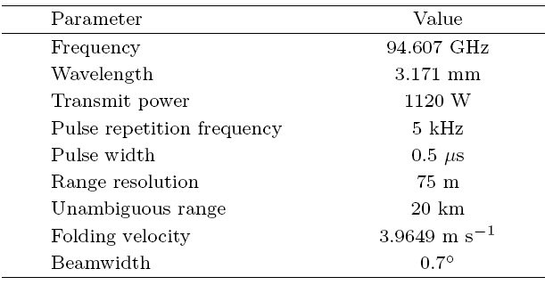
The SKY millimetre-wave cloud radar is the first94-GHz radar developed by China; thus,it is fairlychallenging to obtain echoes based on the currenthardware technology. The main parameters of theSKY cloud radar are listed in Table 1.
The cloud liquid water content and particle effectiveradius are important microphysical parameters.For an assumed log normal droplet size distribution,the relationships between reflectivity factor,dropleteffective radius(re; μm), and liquid water content(LWC; g m−3)are expressed as follows(Frisch et al., 1995; Danne et al., 1999; Shupe et al., 2004):
where Z is reflectivity factor(mm6 m−3),N is dropletnumber concentration(cm−3),σ is the logarithmicspread of the droplet size distribution, and ρ is densityof water reflectivity. Equations(1) and (2)indicate that Z-LWC and Z-re relations can be determined ifσ and N are selected according to the cloud type.

The Z-LWC relationship in weakly nonprecipitatingclouds was suggested by Atlas(1954),Sauvageot and Omar(1987), and Fox and Illingworth(1997). Many measurements that were taken by aircraftshow that drizzle often appears in clouds witha reflectivity factor approaching –15 dBZ(Sauvageot and Omar, 1987). Baedi et al.(2000)obtained theLWC of stratocumulus with drizzle. The radar reflectivityfactor of precipitating particles is larger,but thecontribution to the cloud LWC is minimal. Therefore,the presence of precipitation in the clouds should influencethe interpretation of cloud water content. Asa result,suitable inversion formulas should be selectedaccording to cloud particle types.
Two methods are used to distinguish clouddroplets from precipitating particles. First,particleswith radii less than 25 μm mainly grow by condensation,whereas particles with radii greater than 25μm mainly grow by coalescence(Cober et al., 1996).Thus,a 25-μm radius can distinguish different particletypes in clouds(Frisch et al., 1995; Kollias et al., 2011a). Kollias et al.(2011a)suggested that the valueof Z in the range of –20 to –15 dBZ and the spectralwidth of 0.25 m s−1 indicate the generation of drizzlewith radii larger than 25 μm. Second,particles withradii larger than 100–125 μm are considered precipitationparticles because they often reach the ground,whereas particles with radii less than 100 μm are consideredcloud droplets because their falling speed issmall,according to the relationship between size and falling speed of the particles(Sauvageot and Omar, 1987). Zong(2013)suggested that the threshold(theradius of the particles greater than 100 μm)is –15to –12 dBZ. In this study,we assume that particlessmaller than 50 μm are cloud droplets,whereas thoselarger than 1 mm are raindrops. Particles with radiifrom 25 to 500 μm are treated as drizzle. Thus,thedistinction between cloud droplets and drizzle drops isa 25-μm radius. In calm conditions,the falling speedof cloud droplets is only a few centimetres per second,which is lower than the atmospheric vertical speedby 1–2 orders of magnitude. Hence,the cloud droplet movement can be regarded as air movement(Kollias et al., 2002; Shupe et al., 2008).3. Analysis of the first cloud echoes observedby SKY radar
On 8 June 2013,the SKY cloud radar successfullydetected cloud echoes in Hefei,Anhui Province(31.821◦N,117.19◦E)for the first time. The specifictime was 1357–1427 BT(Beijing Time) and 1523–1536BT. The radar was zenith pointing and installed on anautomobile.3.1 Analysis of weather conditions
To better analyze the cloud radar echoes,we firstexamine the background real weather conditions usingsatellite cloud images,weather charts,sounding data, and ground observations on 8 June 2013.3.1.1 Weather chart analysis
Figure 1 shows the 500-hPa geopotential height and temperature fields, and 850-hPa wind field at 0800BT 8 June 2013. A developed cyclone,namely,theJiang-Huai cyclone,is seen near Jiangsu Province and the East China Sea at this time. The cyclone is steeredby the westerlies. Meanwhile,there is a low-leveltrough over Jiangsu and Zhejiang provinces,which isoriented southwest to northeast. An encounter betweenthe southwest warm moist air flows ahead ofthe trough and the northwest air behind the troughleads to atmospheric instability. Combined with favorablemoisture conditions,it is easy to form clouds and precipitation. At 2000 BT 8 June(figure omitted),the low trough weakens and slightly shifts to theeast; later,it gradually exits the territory of AnhuiProvince and shifts to the east.3.1.2 Analysis of FY2E satellite cloud image
Figure 2 displays the infrared bright temperaturefrom the FY2E satellite at 1400 BT 8 June 2013. TheJiang-Huai cyclone center seems not associated withsevere weather,such as heavy rain. It is clearly seenthat low clouds appear over Hefei City.3.1.3 Anqing sounding data analysis
The Anqing sounding station is the nearest soundingstation(30.53◦N,117.05◦E)to the radar location;thus,the sounding data are used as a reference. Figure 3 presents the T-logP relation over Anqing at 1400 BT8 June 2013. It is indicated that the water vapor atlow altitudes over the station is sufficient. The differencebetween the dew point and actual temperatureis less than 2℃, and the relative humidity is higherthan 85% between 925 and 770 hPa. The differencesare 1℃ and 94% at 925 hPa(near saturation). A stratocumuluslayer exists between 925 and 770 hPa,inwhich the cloud base is approximately 720 m and thecloud top is near 2.7 km. The depth of the liquid layeris approximately 1 km, and the height of the freezinglevel is approximately 5.2 km.
 |
| Fig. 1. Weather chart of geopotential height(blue) and temperature(red)at 500 hPa, and wind(barb)at 850 hPaat 0800 BT 8 June 2013. |
 |
| Fig. 2. Infrared bright temperature from FY2E satelliteat 1400 BT 8 June 2013. |
According to the surface observation data at1400 BT 8 June 2013 from Hefei station(31.87◦N,117.23◦E),which is nearest to the experiment site,the weather was cloudy,then characterized by intermittentlight rain. Fracto-nimbus with a cloud baseheight of 300 m developed,which produced 0.2 mm of rainfall within 6 h and a surface wind speed of 2 m s−1.The Anqing station,which is a bit farther from the experimentsite,recorded cloudiness. Initially,the rainwas light. Stratocumulus clouds were present with acloud base of 300 m and a surface wind speed of 4 ms−1.
 |
| Fig. 3. T-logP plot over Anqing sounding station at 1400 BT 8 June 2013. |
Figure 4 shows the radar reflectivity factor,Doppler velocity,Doppler velocity spectral width, and linear depolarized ratio(LDR)during 1347–1357 BT8 June 2013. As the cloud radar is vertical pointing,the Doppler velocity is also the mean falling velocityof the droplets. LDR can reveal the non-sphericalextent of particles. The height of the cloud top isapproximately 2.0 km and the cloud is likely low stratocumulusas judged by previous and current radarechoes. The Doppler speed at the cloud top indicates adowndraft. Due to artificial settings,the radar cannotobserve the cloud base. According to surface observations,the height of the cloud base is approximately300 m,so the thickness of the cloud is roughly 1.7 km.Figure 4 also shows that the radar reflectivity factorof the cloud is –27 to 0 dBZ, and the spectral widthis higher than 0.25 m s−1(i.e.,drizzle exists in thecloud). The reflectivity factor threshold of the precipitatingparticles is above –20 dBZ, and the spectralwidth of the two types of particles is higher than 0.25 m s−1(Baedi et al., 2000). Furthermore,the radar reflectivityfactor,Doppler velocity, and spectral widthincrease as the height decreases,indicating growth ofcloud droplet with height. Below 1 km,the correspondingspectral width exceeds 0.4 m s−1,which suggeststhat the drizzle in the cloud is enhanced. Twozones of changing velocity are shown at the bottomof Fig. 4b at 1356 BT. These ambiguous velocitiesare due to the fact that the actual velocity exceeds4 m s−1,which is attributed to large particles. TheLDR is less than –20 dB in the case of spherical particles,which is consistent with the results obtainedwith China’s 35-GHz radar(Sun,2011). Accordingto the Doppler velocity shown in Fig. 4b,no upwardmovement occurs in the cloud. Above 2 km,thecloud region in which the Doppler velocity reaches 0 or–3.5 m s−1 appears as noise in the radar system.
Figure 5 shows the vertical profiles of the radarreflectivity factor,Doppler velocity,Doppler velocityspectral width, and LDR at 1349 BT 8 June 2013.The velocity(–3.5 m s−1)jumps to –1.1 m s−1 over arange of approximately 100 m,which is unreasonable.It may be explained by the low radar signal to noiseratio(SNR). Near the cloud top of 2 km,the radar reflectivityfactor is less than –25 dBZ and the spectralwidth is nearly 0 m s−1,which reveals a low concentrationof small particles at the cloud top. Furthermore,Z is –14 dBZ,which corresponds to a spectral width of approximately 0.25 m s−1 over about 1.5 km; thus,drizzle appears. Near 1.25 km,at high radar reflectivityfactors(–5 dBZ),the spectral width “jumps” to a higher value(about 0.4 m s−1) and LDR “jumps”to a lower value(approximately –25 dB). This suggeststhe increasing contribution of PSD broadening to the observed Doppler spectral width values due todrizzle growth. At even higher radar reflectivity factors,the spectral width continues to slowly increasesuch that the drizzle droplets in the cloud region growby coalescence and fall to the ground. Above 1.5–1.7 km,the radar reflectivity factor,Doppler velocity, and spectral width increase as the height decreases;this reveals that the cloud droplets grow mainly bycondensation. A low reflectivity factor(< –20 dBZ)or low spectral width(< 0.25 m s−1)indicates thatthe vertical Doppler velocity is a good representationof the air motion(Frisch et al., 1995). The spectralwidth distribution shows cloud droplets above 1.5 km,so the corresponding mean Doppler velocities can betreated as the vertical velocity of the air. Then,thevertical velocity of the air within the cloud changeswith height. At Z = –25 dBZ(about 1.8 km),weobserve that the vertical velocity of the air is approximately–1.1 m s−1. The LDR is around –20 dB, and itdoes not exist above 1.5–1.6 km,which corresponds toa maximum Z of –14 dBZ and spectral width of 0.25m s−1. The values of LDR> –10 dB at 1.7 km aretoo large to be credible.
 |
| Fig. 4.(a)Radar reflectivity factor,(b)Doppler velocity,(c)Doppler velocity spectral width, and (d)LDR during1347–1357 BT 8 June 2013. |
 |
| Fig. 5. Vertical profiles of(a)radar reflectivity factor,(b)Doppler velocity,(c)Doppler velocity spectral width, and (d)LDR at 1349 BT 8 June 2013. |
Figure 6 shows the radar reflectivity factor,Doppler velocity,Doppler velocity spectral width, and LDR during 1407–1417 BT 8 June 2013. According tothe examination of all the echoes observed by the radarin the afternoon,some protrusions from the cloud topappear to be stratocumulus clouds. Drizzle fades away and evaporates completely before reaching the ground.The positive velocity within the cloud top at 1409 BTis caused by the updraft. After 1411 BT,Z changesfrom –15 to –35 dBZ and a spectral width smaller than0.25 m s−1 appears,indicating that the drizzle has disappeared.Additionally,the vertical velocities of theair within the cloud change greatly with height. At the0.5-km altitude,values of Z and spectral width of thecloud decrease to –35 dBZ and 0 m s−1,respectively, and no LDR exists,which explains the height of thecloud base. Figure 6 also indicates that clouds withspectral widths larger than 0.4 m s−1 often exhibit ahigher reflectivity factor(Z > –10 dBZ)due to thecontribution of drizzle.
Figure 7 displays the vertical profiles of radar reflectivityfactor,Doppler velocity, and Doppler velocityspectral width at 1409 BT 8 June 2013. Below2 km,the radar reflectivity factor first increases and then decreases as height decreases; the spectral widthhas a corresponding change,but the Doppler velocitybasically increases as height decreases. This indicatesthat cloud droplets and drizzle first grow and then evaporate. At the highest radar reflectivity factor(–10 dBZ),the spectral width decreases rapidly(from0.3 to 0.25 m s−1),but the Doppler velocity retainsits highest value(–3 m s−1). This is the contributionof PSD narrowing to the observed Doppler spectralwidth values due to small cloud droplets evaporatingfirst. At the height of 0.6 km with Z = –27 dBZ,the Doppler velocity begins to decrease and reveals acloud base height of approximately 0.6 km. Althoughthe largest Z is –10 dBZ and the largest spectral widthis 0.35 m s−1,only one value of LDR appears,so LDRis not shown.
Figure 8 shows radar reflectivity factor,Dopplervelocity,Doppler velocity spectral width, and LDRduring 1524–1534 BT 8 June 2013. Combined withprevious detections,Fig. 8 indicates that the cloudhas newly developed non-uniformity in the vertical and horizontal structures(i.e.,the cloud top is no longerflat). The largest reflectivity factor in the cloud is –5dBZ,at which point drizzle is produced again. Theupper part of the cloud dissipates over time, and thedrizzle evaporates while falling. Meanwhile,the lowerpart of the cloud develops over time. The radar reflectivityfactor,Doppler velocity, and spectral widthincrease as height decreases after 1531 BT.When spectralwidth reaches 0.8 m s−1 and LDR is less than –20dB,drizzle should fall. At the height of 500 m between1531 and 1532 BT,the largest upward velocity is1 m s−1. Because the Doppler velocity near the cloudregion with upward motion changes continuously,theupward velocity is updraft,rather than fuzzy velocity,which indicates air turbulence. This should accountfor the rain on the following day.
Figure 9 displays the vertical profiles of radarreflectivity factor,Doppler velocity,Doppler velocityspectral width, and LDR at 15:31:03 BT 8 June 2013.The upper part of the cloud disappears gradually, and the radar reflectivity factor of the lower part of thecloud generally increases as height decreases. Thus,the particles increase,but the corresponding Doppler velocity first increases and then decreases. At 0.6 km,updrafts occur,which lead to the velocity decrease below0.8 km. This is associated with a large spectral width and an LDR increase from –20 to –18 dB. Theminimum Z = –16 dBZ corresponds to a measurableLDR by the radar and shows that the threshold can be reduced in the case of air turbulence. By analyzingtest data,the threshold is found to be commonly–11 to –14 dBZ and to decrease with turbulence en hancement(e.g.,the lowest threshold in the test is –20dBZ).
Among all the radar echoes on the experimentday,the detectable minimum reflectivity factor isabout –35 dBZ at 1 km. The echo data show that ithas drizzled off and on,which agrees with the actualweather reports. The radar can clearly observe therapidly changing microphysical parameters and thephysical characteristics of the stratocumulus clouds.
 |
| Fig. 6.(a)Radar reflectivity factor,(b)Doppler velocity,(c)Doppler velocity spectral width, and (d)LDR during1407–1417 BT 8 June 2013. |
 |
| Fig. 7. Vertical profiles of(a)radar reflectivity factor,(b)Doppler velocity, and (c)Doppler velocity spectral width at1409 BT 8 June 2013. |
 |
| Fig. 8. As in Fig. 6,but for 1524–1534 BT 8 June 2013. |
 |
| Fig. 9. Vertical profiles of(a)radar reflectivity factor,(b)Doppler velocity,(c)Doppler velocity spectral width, and (d)LDR at 15:31:03 BT 8 June 2013. |
The detection capability of the SKY cloud radar isfurther analyzed by cloud microphysics retrievals during1347–1357 and 1407–1417 BT. Because the cloudsare warm,we retrieve the cloud liquid water content and particle effective radius. It is known that radarreflectivity factor is proportional to the sixth powerof the particle diameter. Therefore,echo intensity ofthe cloud is controlled by the drizzle in the cloud,butthe contribution of the drizzle to the liquid water contentis smaller than that of cloud droplets at the sameecho intensity. For the clouds containing drizzle,thecloud water content is obtained by using the equationin Baedi et al.(2000). Furthermore,the effective radiiof the cloud droplets and drizzle are estimated basedon Eq.(1).
According to Frisch et al.(1995),Baedi et al.(2000), and Kollias et al.(2011a,b),when retrievingparticle effective radius,we use the Doppler velocityspectral width of 0.25 m s−1 as the threshold to distinguishcloud droplets and drizzle in the cloud. During 1347–1357 BT,a logarithmic spectral width of 0.32,a concentration of 35 cm−3 for cloud droplets, and aconcentration of 0.05 cm−3 for drizzle,are used. Theparticle effective radius and cloud liquid water contentretrieved are depicted in Figs. 10 and 11,respectively.Figure 10 shows that the cloud droplet effective radiusin the upper boundary of the cloud is approximately10 μm. The effective radii of a number ofdrizzle droplets at the 500-m altitude are 70–100 μm.According to surface observations,it is drizzling. Theparticles in the cloud should grow while falling to theground. Therefore,an effective radius larger than 70μm for a large number of drizzle droplets in the cloudis reasonable in the inversion. In fact,cloud dropletsare also found in the area,but are not reflected becausethe reflectivity factor of the drizzle obscures thereflectivity factor of the cloud droplets.
Figure 11 indicates that the liquid water contentof the cloud is mainly 0.2–0.6 g m−3. The lowest watercontent is located at the cloud boundary,while thehighest water content reaches 0.99 g m−3,accordingto the calculations. When the drizzle is stronger,thecloud water content is larger. Based on the statistics,the cloud liquid water content of stratus or stratocumulusis 0.4–0.8 g m−3,so the results are reasonable.
By using the same method,the particle effectiveradius and cloud liquid water content during 1407–1417 BT are retrieved and shown in Figs. 12 and 13,respectively. The logarithmic spectral width of 0.31,the concentrations of 35 cm−3 for cloud droplets, and 0.01 cm−3 for drizzle,are used in Eq.(1). Figure 12indicates that the effective radius of cloud droplets isapproximately 10 μm,the largest drizzle is 79 μm, and the drizzle gradually disappears as time passes.
 |
| Fig. 10. Effective radius of the particles in the cloud during 1347–1357 BT 8 June 2013. |
 |
| Fig. 11. Liquid water content of the cloud during 1347–1357 BT 8 June 2013. |
 |
| Fig. 12. Effective radius of the particles in the cloud during 1407–1417 BT 8 June 2013. |
 |
| Fig. 13. Liquid water content of the cloud during 1407–1417 BT 8 June 2013. |
Figure 13 indicates that the cloud water content is0.1–0.8 g m−3. The low cloud water content is locatedat the boundary of the cloud and higher cloud watercontent is located near the cloud center. Additionally,the water content in the cloud area containing largedrizzle droplets is approximately 0.6 g m−3.
If the cloud during 1407–1417 BT is mistaken for weak cloud(i.e.,drizzle is not distinguished from clouddroplets),the effective radius and liquid water contentcan be calculated by using the empirical relationsproposed by Fox and Illingworth(1997). Figure 14ashows that the cloud particle effective radii are 7–20μm,larger particles mainly exist in the middle of thecloud, and the particle effective radius decreases overtime. However,the result is not reasonable because drizzle is missed in the inversion. Figure 14b showsthat the liquid water content is 0.1–3.5 g m−3 and thecloud liquid water at the boundary is low. The liquidwater content for the cloud without drizzle after 1411BT is reasonable,but that of the cloud containing drizzleis clearly overestimated. Therefore,the results ofthe retrievals are greatly impacted by the judgment ofwhether it is drizzling or not in a cloud.
 |
| Fig. 14.(a)Effective radius and (b)liquid water content of the cloud,assuming no precipitation in the cloud during1407–1417 BT 8 June 2013. |
By using the cloud echoes first successfully detectedby China’s indigenous 94-GHz SKY cloudradar,the detection capability of the cloud radar isevaluated through analyzing the macrostructure and microphysical parameters of stratocumulus clouds.The results prove to be of good reference for furtherresearch and improvement of the W-b and cloud radar.
(1)The cloud radar can observe the time-varyingmacro- and microscopic cloud parameters and revealthe microscopic structures and small-scale changes ofthe clouds such as turbulence. The evolving echoesreflect changes of droplet parameters and structuresof the cloud with drizzle. In our experiment,the detectable minimum reflectivity factor is about –35 dBZ(i.e.,the radar’s sensitivity is high). Observations ofthe echoes are consistent with the actual weather conditions.
(2)The vertical air velocity of low clouds changeswith time and height. The velocity spectral width ofa certain type of particle is small,but the spectralwidth containing cloud droplets and drizzle is large.When the spectral width is more than 0.4 m s−1,theradar reflectivity factor is usually larger(more than–10 dBZ). The threshold is commonly –11 to –14 dBZ,which corresponds to a measurable LDR by the radar and decreases with turbulence enhancement.
(3)After distinguishing the cloud droplets fromdrizzle,we obtained the liquid water content and theeffective radii. Drizzle has a high radar reflectivity factor,but it has lower liquid water content than clouddroplets at the same reflectivity factor. In the experiment,the effective radius of the droplets in the cloudis approximately 10 μm,the drizzle effective radius isgreater than 25 μm, and the largest effective radius isover 90 μm.
Because we assume that the values of the particleconcentration and logarithmic spectral width in the inversion are constant,the results using the Z–re relationshiphave uncertainties. The uncertainties inall-liquid clouds are approximately 50% for LWC(Fox and Illingworth, 1997) and 13% for re(Frisch et al., 2002). The inversion results are not validated by aneffective mean. In the present study,no attenuationcorrection is applied to the W-b and radar reflectivitymeasurement. The attenuation is proportional to theliquid water content in the region of Rayleigh scattering.Because the cloud radar is still being developed and debugged,no other echoes have been obtained and strong noise sometimes occurs in the detectingsystem. Furthermore,we did not remove the noise inthe inversion. In later work,the software and hardwaresystems of the radar will be improved,morestable and reliable data can be obtained, and airbornedetection should ultimately be implemented. Whenusing the Doppler radar output spectrum,we caninvert and retrieve the droplet liquid water content,drizzle liquid water content,drizzle effective radius, and vertical movement of the air in a precipitatingcloud. In the future,the simultaneous use of severalremote sensing instruments with different wavelengthsis desired to reduce the errors due to inaccuracies inthe measured quantities.
Acknowledgments.We thank Professor ChenDaren for his significant help.
| Atlas, D., 1954: The estimation of cloud parameters by radar. J. Meteor., 11, 309-317. |
| Babb, D. M., and J. Verlinde, 2000: The retrieval of turbulent broadening in radar Doppler using linear inversion with double-sided constraint. J. Atmos. Oceanic Technol., 17, 1577-1583. |
| Baedi, R. J. P., J. J. M. de Wit, H. W. J. Russchen-berg, et al., 2000: Estimating effective radius and liquid water content from radar and lidar based on the CLARE'98 dataset. Phys. Chem. Earth, 25, 1057-1062. |
| Clothiaux, E. E., K. P. Moran, B. E. Martner, et al., 1999: The atmospheric radiation measurement pro-gram cloud radars: Operational modes. J. Atmos. Oceanic Technol., 16, 819-827. |
| Cober, S. G., J. W. Strapp, and G. A. Isaac, 1996: An ex-ample of supercooled drizzle drops formed through a collision-coalescence process. J. Appl. Meteor., 35, 2250-2260. |
| Danne, O., M. Quante, D. Milferstadt, et al., 1999: Rela-tionships between Doppler spectral moments within large-scale cirro-and altostratus cloud fields ob-served by a ground-based 95 GHz cloud radar. J. Appl. Meteor., 38, 175-189. |
| Fox, N. I., and A. J. Illingworth, 1997: The retrieval of stratocumulus cloud properties by ground based cloud radar. J. Appl. Meteor., 36, 485-492. |
| Frisch, A. S., C. W. Fairall, J. B. Snider, 1995: Mea-surement of stratus cloud and drizzle parameters in ASTEX with a Ka -band Doppler radar and a mi-crowave radiometer. J. Atmos. Sci., 52, 2788-2799. |
| —-, —-, G. Feingold, et al., 1998: On cloud radar and mi-crowave radiometer measurements of stratus cloud liquid water profiles. J. Geophys. Res., 103(D18), 23195-23197. |
| —-, M. Shupe, I. Djalalova, et al., 2002: The retrieval of stratus cloud droplet effective radius with cloud radars. J. Atmos. Oceanic Technol., 19, 835-842. |
| Gossard, E. E., R. O. Strauch, and R. R. Rogers, 1990: Evolution of drop size distributions in liquid precip-itation observed by ground-based Doppler radar. J. Atmos. Oceanic Technol., 7(6), 815-828. |
| Hamazu, K., H. Hashiguchi, T. Wakayana, et al., 2003: A 35 GHz scanning Doppler radar for fog observations. J. Atmos. Oceanic Technol., 20, 972-986. |
| Hogan, R. J., A. J. Illingworth, and H. Sauvageot, 2000: Measuring crystal size in cirrus using 35 and 94 GHz radars. J. Atmos. Oceanic Technol., 17, 27-37. |
| Illingworth, A. J., R. J. Hogan, E. J. O'Connor, et al., 2007: Cloudnet-continuous evaluation of cloud pro-files in seven operational models using ground-based observations. Bull. Amer. Meteor. Soc., 88, 883-898. |
| Kollias, P., B. A. Albrecht, and F. Marks, 2002: Accurate observations of vertical air velocities and raindrops using a cloud radar. Bull. Amer. Meteor. Soc., 83, 1471-1483. |
| —–, J. R´emillard, E. Luke, et al., 2011a: Cloud radar Doppler spectra in drizzling stratiform clouds: 1. Forward modeling and remote sensing applications. J. Geophys. Res., 116, D13201, doi: 10.1029/2010JD015237. |
| —–, W. Szyrmer, J. R´emillard, et al., 2011b: Cloud radar Doppler spectra in drizzling stratiform clouds:2. Observations and microphysical modeling of drizzle evolution. J. Geophys. Res., 116, D13203, doi: 10.1029/2010JD015238. |
| Kropfli, R. A., S. Y. Matrosov, T. Uttal, et al., 1995: Cloud physics studies with 8-mm wavelength radar. Atmos. Res., 35, 299–313. |
| Krofli, R. A., and R. D. Kelly, 1996: Meteorological research applications of mm-wave radar. Meteor. Atmos. Phys., 59, 105-121. |
| Lhermitte, R. M., 2002: Centimeter & Millmeter Wavelength Radars in Meteorology. Lhermitte Publications, Miami, Florida, 389–546. |
| Liou, K. N., 1986. Influence of cirrus clouds on weather and climate processes: A global perspective. Mon. Wea. Rev., 114, 1167-1199. |
| [22] O'Connor, E. J., A. J. Illingworth, and R. J. Hogan, 2004: Retrieving stratocumulus drizzle parameters using Doppler radar and lidar. J. Appl. Meteor., 44, 14-27. |
| Sassen, K., and L. Liao, 1996: Estimation of cloud con-tent by W band radar. J. Appl. Meteor., 35, 932-938. |
| —-, G. G. Mace, Z. Wang, et al., 1999: Continental stra-tus clouds: A case study using coordinated remote sensing and aircraft measurements. J. Atmos. Sci., 56, 2345-2358. |
| Sauvageot, H., and J. Omar, 1987: Radar reflectivity of cumulus clouds. J. Atmos. Oceanic Technol., 4,246–272. |
| Shupe, M. D., P. Kollias, S. Y. Matrosov, et al., 2004: De-riving mixed-phase cloud properties from Doppler radar spectra. J. Atmos. Oceanic Technol., 21, 660-670. |
| —-, —-, M. Poellot, et al., 2008: On deriving vertical air motions from cloud radar Doppler spectra. J. Atmos. Oceanic Technol., 25, 547-557. |
| Sun Xiaoguang, 2011: Millimeter wave radar data pro-cessing and the cloud aviation meteorological guar-antee applied research. Master dissertation, PLA University of Science and Technology, 1-5, 24-35. |
| Zhong Lingzhi, Liu Liping, and Ge Runsheng, 2009: Characteristics about the millimeter-wavelength radar and its status and prospect in and abroad. Adv. Earth Sci., 24, 383-391. |
| —–, —–, Chen Lin, et al., 2010: A potential application of a millimeter wavelength radar to studying the cloud physics mechanism for ice and snow weather. Acta Meteor. Sinica, 68, 705–716. (in Chinese) |
| Zong Rong, 2013: Detection and research for macro and micro characteristics of cloud by millimeter-wave radar. Ph. D. dissertation, Dept. of Physics, Nan-jing University of Information Science & Technology, China, 30-85. |