文章信息
- 田晓瑞, 舒立福, 赵凤君, 王明玉
- Tian Xiaorui, Shu Lifu, Zhao Fengjun, Wang Mingyu
- 中国主要生态地理区的林火动态特征分析
- Dynamic Characteristics of Forest Fires in the Main Ecological Geographic Districts of China
- 林业科学, 2015, 51(9): 71-77
- Scientia Silvae Sinicae, 2015, 51(9): 71-77.
- DOI: 10.11707/j.1001-7488.20150910
-
文章历史
- 收稿日期:2014-02-28
- 修回日期:2015-07-26
-
作者相关文章
火干扰影响植被动态的格局和过程,植被组成和结构取决于气候和火烧的频度与强度,反过来,火烧的频度和强度也取决于植被结构、地形、植被生产力和气候等。遥感技术(RS)的应用为在大空间尺度上研究森林火灾分布提供了有效的手段(邓湘雯等2004)。在全球尺度上,不同森林生态系统中的火烧频度和强度有很大差异,全球每年过火面积200~500亿hm2,包括稀树草原(200~400亿hm2)、北方森林(5~15亿hm2)和其他受火影响的森林、林地和灌木林等(Parry et al.,2007)。Schoennagel等(2004)研究表明,过火面积最多的地区包括非洲热带稀树草原、澳大利亚、东南亚以及北方森林,而受气候变化(主要指温度升高和干旱期频繁出现等)和极端天气事件的影响,未来亚洲的北方森林火灾发生频率和范围将增加,北美洲的野火(wildfire)可能由于气候偏暖、土壤更干燥和生长季更长而加剧。
火是生态系统发展变化的重要动力(Whitlock et al.,2010),随着植被、气候和人为干扰强度的变化,林火动态也将发生改变。例如,自20世纪初期开始的扑救所有林火的政策使得美国西部森林从20世纪末开始连续发生高强度火灾(Covington et al.,1994)。对原本是火适应或火依赖的森林生态系统占主导的区域内的火烧进行控制,会改变演替格局,引起森林组成和年龄结构变化。中国对林火动态的研究主要集中于东北林区,如:黑龙江省林火发生规律(胡海清等,2002)和大兴安岭森林火灾变化规律(于成龙等,2007;郭福涛等,2010);林火空间格局及影响因素(陈宏伟等,2011;刘志华等,2011);基于树轮火疤研究火烧频度(胡海清等,2010)等。多年来中国实施的“预防为主,积极消灭”的森林防火政策,在很大程度上改变了森林生态系统中自然的火干扰状态。大兴安岭地区森林火周期的延长会使林地可燃物载量增加,进而导致潜在火强度升高(田晓瑞等,2005)。因此,充分认识当前的林火动态及其对生态系统的影响,是制定林火科学管理策略的基础。
1 数据来源与研究方法 1.1 数据来源2005—2012年卫星监测到的热点数据来源于国家林业局林火监测中心,卫星源包括FY-1D,FY-1C,FY-3A,FY-3B,HJ-1B,Aqua,Terra,NOAA-12,NOAA-14,NOAA-16,NOAA-17,NOAA-18和NOAA-19,其中目前运行的卫星有FY3A,FY3B,NOAA(NOAA16,18,19)和EOS系列(TERRA,AQUA)等7颗卫星,每天可对同一地区扫描10次左右。热点信息主要包括接收时间、地点、经纬度、像素数、连续性、地类及相关反馈情况,本文采用的数据是经过地面核查过的热点数据。林火统计数据来源于国家林业局森林防火办公室,包括按省(区、市)统计的火灾次数、过火面积、伤亡人数等指标。
1.2 卫星监测热点数据分析卫星监测数据包括所有热点信息,根据热点属性特征,利用Arcinfo10.0软件提取各生态地理区的热点信息,并分析这些区域的热点空间与时间分布特征。
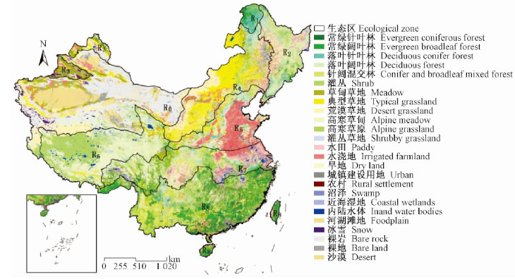
1.3 生态地理分区生态区划是区域生态环境管理的基础和前提(郭慧等,2013),通过对代表自然界宏观生态系统的生物和非生物要素的地理相关性进行比较和综合分析,按自然地理地带分异规律,划分或合并而形成不同等级的区域系统(吴绍洪等,2003)。郑度(2008)根据温度带、湿润度和植被类型,利用三级分类体系把中国分成49个自然区。本文基于中国生态地理区域系统的2级分类和植被类型,结合中国森林火灾特点,把中国大陆植被划分为8个区域:寒温带湿润地区落叶针叶林区(R1)、中温带湿润地区森林区(R2)、中温带干旱地区荒漠针叶林区(R3)、中温带半干旱地区草原区(R4)、暖温带湿润/半湿润地区落叶阔叶林及人工植被区(R5)、中温带半干旱/干旱地区草原区(R6)、中北亚热带湿润地区阔叶林及人工植被区(R7)和热带南亚热带湿润地区阔叶林及人工植被区(R8)(图 1),分析各个生态地理区的林火分布特征。考虑到中国赤道热带和边缘热带区面积较小,将其合并到林火特征相似的南亚热带区。中温带干旱地区荒漠区基本没有植被,不存在火干扰,因此,不对该区域进行分析。
 |
图 1 中国植被与生态地理区分布 Fig. 1 Distribution of vegetation and ecological zones in China |
中国的林火统计是按省(区、市)进行的,数据包括每年的森林火灾次数、过火面积和受害森林面积。由于部分省(区、市)跨生态地理区分布,因此,需根据这些省(区、市)的森林分布特征对统计数据进行分割与归并计算,获得各生态地理区的森林火灾数据。由于林火统计数据缺乏空间分布信息,本文假设这些省区的森林火灾发生次数与过火面积都与森林分布面积正相关,根据植被分布图分别计算这些跨生态地理区省份中的森林面积比重,并采用这一比重系数统计各生态地理区的森林火灾数据。
2 结果与分析 2.1 2005—2012年野火热点分布及火险期2005—2012年每年卫星探测到的野外热点数量为13 570~20 083(包括野火、农用火、计划烧除等),其中年均探测到的野火(森林、灌丛和草地上的火)4 004起(变动范围 2 035~5 716),2005和2012年分别为最多和最少的年份。
从图 2a可以看出,野火主要分布在东部,其中分布在R8区域的野火占84.4%,分布在R1,R2,R3,R4,R5,R6和R7区域的野火分别占0.5%,3.8%,0.1%,2.7%,2.7%,0.1%和5.8%。卫星监测到连续热点(对同一火场重复探测到的热点)主要分布在R8,R2,R7,R4,R1和R5区(图 2b),分别占61.6%,11.1%,10.6%,6.1%,6.0%和4.3%。连续热点和非连续热点(第1次探测到的野火,相当于火发生次数)数量的比值可以表示火灾的大小和扑救困难程度。R1的连续热点/非连续热点值达到12.0,R8只有0.7,R6为0,其他区域为1.6~3.0。这说明,连续燃烧的火灾主要发生在大兴安岭地区(R1),热带南亚热带湿润地区的火灾虽然发生次数多,但容易扑救,不易出现长时间燃烧的森林大火。
 |
图 2 2005—2012年野火与生态地理区分布 Fig. 2 Wildfires distribution and ecological zones in 2005-2012 a.野外发生的火灾Wildfires distribution; b.卫星连续监测到的野火Continuous hotspots for wildfires. R0为无植被分布区域R0 means no vegetation region. |
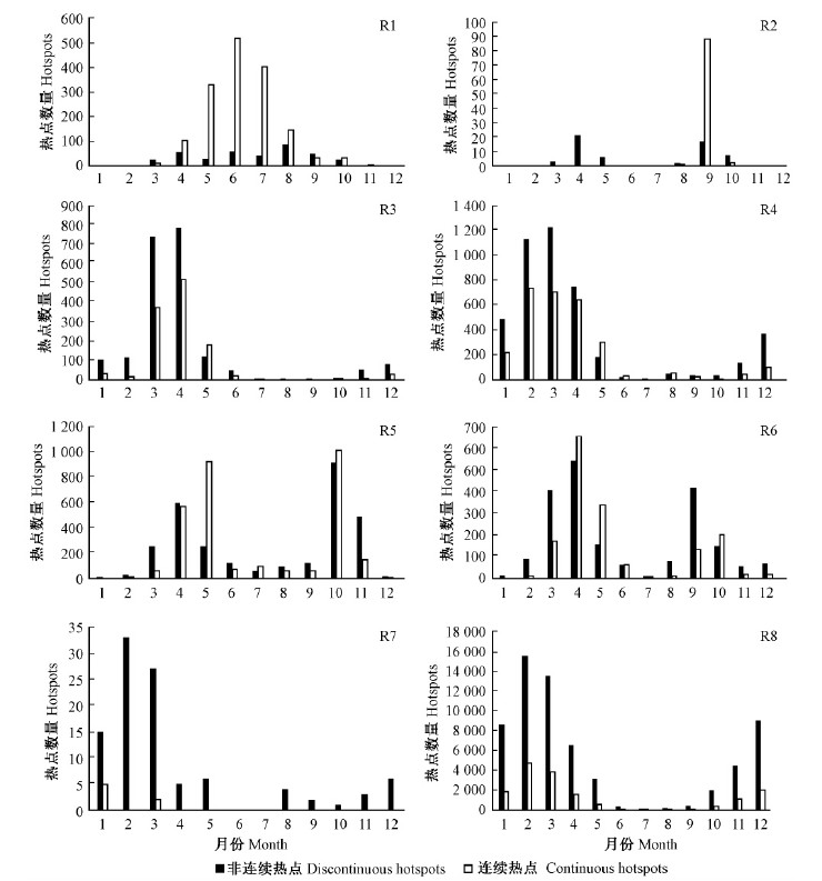
根据研究时段内林火发生时间分布确定了各生态地理区的火险期(表 1)。寒温带湿润地区落叶针叶林区的火险期为3—10月,2,3,9月监测到的非连续热点多于连续热点,但4—8月非连续性热点数量远远少于连续热点,4—8月容易发生持续性的火烧(图 3a)。中温带湿润地区森林区热点出现在2—12月,火灾主要发生在春季(4—5月)和秋季(10—11月)。中温带干旱地区荒漠针叶林区热点主要出现在3—5月和8—10月,连续性的火烧主要发生在9月。中温带半干旱地区草原区的火险期也包括春秋2个时段,虽然其他时段也有少量火灾发生,但连续性的火烧主要出现在4,5和9月。暖温带湿润/半湿润地区落叶阔叶林及人工植被区的火灾主要发生在春季,3—5月是火灾发生的高峰时段。高原亚寒带半湿润/半干旱地区草甸草原区和中北亚热带湿润地区阔叶林及人工植被区的火险期基本一致,火险期为冬春季(12—5月),以春季为主。热带南亚热带湿润地区阔叶林及人工植被区全年都可能发生火灾,火险期为11—5月,其中2月和3月是火灾发生的高峰时段(图 3)。
|
|
 |
图 3 各生态地理区的热点分布特征 Fig. 3 Hotspots distribution characteristics in each ecological zone R1.寒温带湿润地区落叶针叶林区The deciduous conifer forest region in cold temperate humid region; R2.中温带湿润地区森林区Temperate humid forest zone; R3. 中温带干旱地区荒漠针叶林区Temperate coniferous forest zone in arid desert region; R4.中温带半干旱地区草原区Temperate grassland in semi-arid areas; R5.暖温带湿润/半湿润地区落叶阔叶林及人工植被区Warm temperate moist/humid deciduous forests region; R6.高原亚寒带半湿润/半干旱地区草甸草原区Temperate semi-arid/arid steppe region; R7.中北亚热带湿润地区阔叶林及人工植被区Meiddle and north subtropical humid broadleaf forests and artificial vegetation region; R8.热带南亚热带湿润地区阔叶林及人工植被区 South subtropical and tropical moist broadleaf forest and artificial vegetation region. |
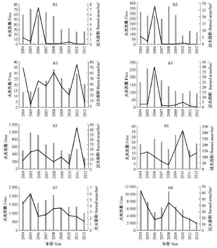
林火发生次数和过火面积是重要的林火动态特征。根据2004—2012年各生态地理区的森林火灾统计(图 4),所有生态地理区的林火动态特征都表现出年际间波动,过火面积的波动性更为明显。
 |
图 4 2004—2012年各生态地理区的森林火灾统计 Fig. 4 Fire statistics for each ecological zones in 2004-2012 |
寒温带湿润地区落叶针叶林区年均发生火灾47次(变动范围 26~71次),年均过火面积11 231 hm2(变动范围 347~74 091 hm2);2006年是火灾最严重的年份,过火面积为74 091 hm2;植被分布区的林火发生频度为0.04次·(104hm2)-1,火循环周期为1 007年。中温带湿润地区森林区年均发生火灾233次,年均过火面积41 062 hm2;该区域过火面积的波动曲线和火发生频度为与R1相似,2006年的过火面积也远远高于其他年份。中温带干旱地区荒漠针叶林区年均发生森林火灾22次,平均每起森林火灾过火面积只有2.0 hm2,火烧频度为0.02次·(104 hm2)-1。中温带半干旱地区草原区火灾发生次数和过火面积曲线与R1和R2类似,2006年过火面积(40 002 hm2)呈现1个高峰;该区域年均发生火灾152次,年均过火面积7 026 hm2。暖温带湿润/半湿润地区落叶阔叶林及人工植被区森林火灾最严重的年份为2011年(过火面积4 198 hm2),该区域年均火灾次数和过火面积分别为615次和1 436 hm2,火烧频度为0.28次·(104hm2)-1。高原亚寒带半湿润/半干旱地区草甸草原区的年均森林火灾次数和过火面积分别为24次和131 hm2,火灾次数年际间波动不大。中北亚热带湿润地区阔叶林、人工植被区火灾发生频度为0.25次·(104hm2)-1,年均发生火灾1 578 次,过火面积3 147 hm2。热带南亚热带湿润地区阔叶林及人工植被区和中北亚热带湿润地区阔叶林及人工植被区的过火面积都呈现出整体下降的趋势,特别是2008—2012年表现出直线下降趋势;前者年均发生森林火灾6 489次,过火面积29 784 hm2,平均单场火灾过火面积只有4.6 hm2,火循环周期为4 547年。
3 结论与讨论中国的林火主要分布在东部区域。气候和植被变化决定了火险期的差异,基于林火的分布特征确定了中国各生态地理区的火险期,北方地区的火灾主要发生在春季和秋季,而南方地区火灾主要发生在冬季和春季。热带南亚热带湿润地区的火灾比较多,但这些火灾比较容易控制,而大兴安岭林区的火灾平均燃烧时间长。
人为干扰对林火动态的影响很大,特别是在人口密度高的南方区域。热带南亚热带湿润地区阔叶林及人工植被区林火发生频度最高,寒温带湿润地区落叶针叶林区的火循环周期最短。
根据林火动态变化和森林经营管理目标适当调整林火管理策略,才能实现森林资源的可持续利用(Dellasala et al.,2004)。林火管理对保护生物多样性有重要影响,需应用综合的林火管理措施,减少灾难性林火发生的概率。降低可燃物载量和改变易燃可燃物的连续分布是改变林火行为的最可行手段(Agee et al.,2005)。美国在20世纪末就开展了大规模的可燃物管理计划,计划烧除和机械清理作为可燃物管理的重要措施用于季节性干旱森林。地表可燃物清理结合冠层可燃物清理能更加有效地减少树冠火发生(Mason et al.,2007)。
长期实施扑救所有林火的政策导致部分地区森林中易燃可燃物大量积累,容易发生高强度火烧,控制或扑救也变得更加困难;特别是在比较偏远的天然林区,一旦初始扑救失败,就容易发展为大面积的高强度火灾,对森林生态系统造成严重损害。中国重要的天然林区——大兴安岭地区的火循环周期显著延长(田晓瑞等,2005; 胡海清,1996),林火发生频度降低,只有实施可燃物管理计划才能避免森林大火的发生。此外,机械清理不能够代替计划烧除,森林生态系统应尽可能地保留一些火烧,使林火动态维持在一个合理水平(McIver et al.,2012)。
| [1] |
陈宏伟, 胡远满, 常 禹, 等. 2011. 呼中林区不同森林采伐方式对林火的长期影响模拟. 北京林业大学学报, 33(5): 13-19. (Chen H W, Hu Y M, Chang Y, et al.2011. Simulating long-term effects of different harvesting modes on forest fire in Huzhong Forest Region, northeastern China. Journal of Beijing Forestry University, 33 (5): 13-19[in chinese]).(  1) 1)
|
| [2] |
邓湘雯, 孙刚, 文定元. 2004. 林火对森林演替动态的影响及其应用. 中南林学院学报, 24(1): 51-55. (Deng X W, Sun G, Wen D Y. 2004. The effects of forest fire on forest succession and its application to forest management. Journal of Central South Forestry University, 24(1): 51-55[in chinese]).(  1) 1)
|
| [3] |
郭福涛, 胡海清, 马志海, 等. 2010. 不同模型对拟合大兴安岭林火发生与气象因素关系的适用性. 应用生态学报, 21(1): 159-164. (Guo F T, Hu H Q, Ma Z H, et al.2010. Applicability of different models in simulating the relationships between forest fire occurrence and weather factors in Daxing'an Mountains. Chinese Journal of Applied Ecology, 21(1): 159-164[in chinese]).(  1) 1)
|
| [4] |
郭慧, 王兵, 牛香. 2013.中国典型生态区划方案对比研究. 广东农业科学, (3):186-188. (Guo H, Wang B, Niu X. 2013. Comparative studies on scheme of Chinese typical ecological regionalization.Guangdong Agricultural Sciences, (3):186-188[in chinese]).(  1) 1)
|
| [5] |
胡海清.1996. 大兴安岭森林火动态的研究.哈尔滨: 东北林业大学博士学位论文. (Hu H Q.1996. Study on the forest fire regimes in Greater Khingan Mountain. Harbin: PhD thesis of Northeast Forestry University[in chinese]).(  1) 1)
|
| [6] |
胡海清, 金森. 2002. 黑龙江省林火规律研究Ⅱ:林火动态与格局影响因素的分析. 林业科学, 38(2): 98-102. (Hu H Q, Jin S. 2002. Study on forest fire regime of Heilongjiang provinceⅡ.Analysis on factors affecting fire dynamics and distributions.Scientia Silvae Sinicae, 38(2): 98-102[in chinese]).(  1) 1)
|
| [7] |
胡海清, 赵致奎, 王晓春, 等. 2010. 基于树轮火疤塔河蒙克山樟子松林火灾的频度分析. 生态学报, 30(23): 6372-6379. (Hu H Q, Zhao Z K, Wang X C,et al.2011. Fire history of Mongolian pine (Pinus sylvestris var.mongolica) forests in Mengkeshan of Tahe, China. Acta Ecologica Sinica, 30(23): 6372-6379[in chinese]).(  1) 1)
|
| [8] |
刘志华, 杨健, 贺红士, 等. 2011. 黑龙江大兴安岭呼中林区火烧点格局分析及影响因素. 生态学报, 31(6): 1669-1677. (Liu Z H, Yang J, He H S, et al. 2011. Spatial point analysis of fire occurrence and its influence factor in Huzhong forest area of the Great Xing'an Mountains in Heilongjiang Province,China. Acta Ecologica Sinica, 31(6): 1669-1677[in chinese]).(  1) 1)
|
| [9] |
田晓瑞,舒立福,王明玉. 2005. 林火动态变化对中国东北地区森林生态系统的影响. 森林防火,(1):21-25. (Tian X R, Shu L F, Wang M Y. 2005.Influences of fire regime changes on the forest ecosystem in northeast China.Forest Fire Prevention, (1):21-25[in chinese]).(  1) 1)
|
| [10] |
吴绍洪,杨勤业,郑度. 2003. 生态地理区域系统的比较研究. 地理学报,58(5):686-694(Wu S H, Yang Q Y, Zheng D. 2003.Comparative study on eco-geographic regional systems between China and USA.Acta Geographica Sinica, 58(5):686-694.[in chinese])( 1) 1)
|
| [11] |
于成龙, 胡海清, 魏荣华. 2007. 大兴安岭塔河林业局林火动态气象条件分析. 东北林业大学学报, 35(8): 23-25. (Yu C L, Hu H Q, Wei R H. 2007.Dynamic analysis of meteorological conditions of forest fire in Tahe forestry bureau of Daxing'an Mountains.Journal of Northeast Forestry University, 35(8): 23-25[in chinese]).(  1) 1)
|
| [12] |
郑度.2008. 中国生态地理区域系统研究.北京:商务印书馆. (Zheng D. 2008.The eco-geographic regional system in China. Beijing: The Commercial Press.[in chinese])(  1) 1)
|
| [13] |
Agee J K, Skinner C N. 2005. Basic principles of forest fuel reduction treatments. Forest Ecology and Management, 211(1): 83-96.( 1) 1)
|
| [14] |
Covington W W, Everett R L, Steele R, et al. 1994.Historical and anticipated changes in forest ecosystems of the inland west of the United States. Journal of Sustainable Forestry, 2(1/2): 13-63.( 1) 1)
|
| [15] |
Dellasala D A, Williams J E, Williams C D, et al. 2004. Beyond smoke and mirrors: a synthesis of fire policy and science. Conservation Biology, 18(4): 976-986.( 1) 1)
|
| [16] |
Mason G J, Baker T T, Cram D S, et al. 2007. Mechanical fuel treatment effects on fuel loads and indices of crown fire potential in a south central New Mexico dry mixed conifer forest. Forest Ecology and Management, 251(3): 195-204.( 1) 1)
|
| [17] |
McIver J D, Stephens S L, Agee J K, et al. 2012. Ecological effects of alternative fuel-reduction treatments: highlights of the national fire and fire surrogate study (FFS). International Journal of Wildland Fire, 22(1):63-82.( 1) 1)
|
| [18] |
Parry M L, Canziani O F, Palutikof J P, et al. 2007. Climate change 2007: impacts, adaptation and vulnerability: working group Ⅱ contribution to the fourth assessment report of the IPCC intergovernmental panel on climate change. Cambridge:Cambridge University Press.( 1) 1)
|
| [19] |
Schoennagel T, Veblen T T, Romme W H. 2004. The interaction of fire, fuels, and climate across Rocky Mountain forests.BioScience, 54(7): 661-676.( 1) 1)
|
| [20] |
Whitlock C, Higuera P E, McWethy D B, et al. 2010. Paleoecological perspectives on fire ecology: revisiting the fire-regime concept. The Open Ecology Journal, 3(2): 6-23.( 1) 1)
|
 2015, Vol. 51

