文章信息
- 韩新生, 邓莉兰, 王彦辉, 熊伟, 李振华, 刘千, 王艳兵, 孙浩
- Han Xinsheng, Deng Lilan, Wang Yanhui, Xiong Wei, Li Zhenhua, Liu Qian, Wang Yanbing, Sun Hao
- 六盘山叠叠沟华北落叶松人工林地上生物量的坡面变化
- Variation of Aboveground Biomass of Larix principis-rupprechtii Plantation along Slopes in the Diediegou Watershed of Liupan Mountains
- 林业科学, 2015, 51(3): 132-139
- Scientia Silvae Sinicae, 2015, 51(3): 132-139.
- DOI: 10.11707/j.1001-7488.20150317
-
文章历史
- 收稿日期:2013-12-28
- 修回日期:2015-01-27
-
作者相关文章
2. 中国林业科学研究院森林生态环境与保护研究所 国家林业局森林生态环境重点实验室 北京 100091;
3. 宁夏农林科学院荒漠化治理研究所 银川 750002
2. Key Laboratory of Forestry Ecology and Environment of State Forestry Administration Institute of Forest Ecology, Environment and Protection, Chinese Academy of Forestry Beijing 100091;
3. Institute of Desertification Control, Ningxia Academy of Agriculture and Forestry Sciences Yinchuan 750002
生物量是评价森林生态系统生产力和研究森林生态系统结构与功能的重要指标(李根等,2012;Genet et al.,2011),也是研究森林生态系统物质循环和能量流动的基础(Browm et al.,1999;Mokany et al.,2006)。大量研究表明,森林生物量主要集中于地上(吕晓涛等,2007;明安刚,2012;Tritton et al.,1987),包括乔木层和林下植被的生物量。目前有关生物量的研究主要集中于生物量大小和组成(陈德祥等,2004;樊后保等,2006;漆良华等,2007;张国斌等,2012)及其受土壤水分(黄德青等,2011;刘国华等,2003;王建国等,2011)、降水(马文红等,2010)、海拔、坡向(张春梅等,2011)、温度和生物因子(Hui et al.,2012;Wen et al.,2009)等的影响,但对生物量的坡面变化鲜为报道。尤其在水分不足,限制植被生长作用明显的半干旱地区,存在显著的坡面土壤水分再分配,并因此可能造成植被生物量的坡面差异。深入研究生物量的坡面分配和变化规律,对精确估计森林生态系统的生物量和指导林业生产均很有帮助。
华北落叶松(Larix principis-rupprechtii)是宁夏南部六盘山地区的主要造林树种之一,在当地水土保持和水源涵养等方面起着重要作用。本研究在六盘山半干旱区的叠叠沟小流域,选择生长着华北落叶松人工同龄纯林的半阴坡和阴坡2个典型坡面,在不同坡位设置标准样地,调查森林地上生物量,定量分析地上生物量的坡面变化规律,为提高坡面样地抽样调查精度、开展森林合理经营提供重要依据,也为森林生态系统的恢复和精细化管理提供理论指导。
1 研究区概况研究区位于六盘山北部的叠叠沟小流域(106°4′55″—106°9′15″ E,35°54′12″—35°58′33″ N),属宁夏回族自治区固原市。当地具有典型的半干旱大陆性季风气候,年均降水量449 mm,集中于7—9月份;年均气温6~7 ℃,全年无霜期130天左右;海拔1 975~2 615 m,东坡和西坡是主要坡向。主要土壤类型为灰褐土,黄土次之。受水分不足限制,该小流域的植被主要是自然草坡和灌丛,现存林分主要是分布在阴坡和半阴坡的华北落叶松人工林,在坡脚或河道旁边有少量杨树(Populus spp.)人工林;自然灌丛主要有虎榛子(Ostryopsis davidiana)、沙棘(Hippophae rhamnoides)和绣线菊(Spiraea salicifolia)等;草本主要有铁杆蒿(Artemisia sacrorum)、白颖薹草(Carex rigescens)、草地风毛菊(Saussurea amara)、乌头(Aconitum carmichaeli)和茭蒿(Artemisia giraldii)等。
2 研究方法 2.1 样地设置与调查在叠叠沟小流域,于2012年选择了生长华北落叶松人工纯林的2个典型坡面,第1个坡面为半阴坡,海拔2 021~2 189 m,平均坡度31°,斜坡长450 m,对应的水平坡长为386 m;第2个坡面为阴坡,海拔2 016~2 173 m,平均坡度21°,斜坡长560 m,对应的水平坡长为522 m。2个坡面上的华北落叶松林同时栽植,调查时林龄为27年生;其初植密度相同,受水源涵养林和天然林保护等工程影响,均未曾抚育,现有密度是自然稀疏的结果。在每个坡面的坡顶、上坡、中上坡、中下坡、下坡和坡脚分别设置1个水平投影面积为20 m×20 m的标准样地,进行每木检测。表 1为样地基本信息。
|
|
按照乔木层、灌木层、草本层、枯落物层,分层调查华北落叶松人工林的地上生物量。
乔木层:调查样地中每株树的树高和胸径,然后依据刘延惠等(2011)建立的六盘山地区华北落叶松地上生物量经验公式(式1),计算每株树的地上生物量,再累加获得整个样地的地上生物量。
| $ \ln \;W = 0.910\;0\ln \left({{D^2}H} \right)- 3.241\;7\;{R^2} = 0.940\;5。 $ | (1) |
式中:W为树木地上生物量,单位为kg ·株-1;D为胸径,单位为cm;H为树高,单位为m。
灌木层:由于林下灌木分布很不均匀,因此调查每种灌木的总株数及其盖度。每种灌木选择3~5个标准株,从基部锯掉后带回实验室,在80 ℃烘箱中烘24 h后对每种灌木的样株分别称干质量,求取单株干质量平均值后乘以每种株数,得到每种灌木的地上生物量;把多种灌木的地上生物量累加得到各样地的灌木层地上生物量。
草本层:在2012年生长季中期,每块样地中设置5个1 m×1 m的样方,调查草本盖度将所有草本从基部剪掉后带回实验室。把所有草本一起放到65 ℃的烘箱中烘15 h后称干质量,求得5个样方的干质量平均值,计算样地草本层的地上生物量。
枯落物层:在每块样地设置5个1 m×1 m样方,收集每个样方内枯落物样品,放到烘箱中在80 ℃下烘24 h后称干质量,求得5个样方的干质量平均值,计算得到样地枯落物层的生物量。样地地上生物量:累加样地各层次地上生物量(乔木层、灌木层、草本层、枯落物层),得到样地的地上生物量。再计算获得单位林地面积的地上生物量。
地上生物量的坡面滑动平均值:指从坡顶样地向下,依据各样地所代表坡段长度,进行某个指定样地及其上坡所有样地的地上生物量的坡段长度加权平均,作为从坡顶到指定样地的坡段平均地上生物量;当所有样地参与计算时,可获得整个坡面的平均地上生物量。
2.3 土壤密度和含水量测定采用环刀法测定土壤密度,测定土层分别为0~10,10~20,20~40,40~60,60~80和80~100 cm,共6层,每个样地每层3次重复。在2012年生长季的5—10月,采用土钻法测定土壤质量含水量,在各样地附近分层取样,每月2次,每个样地3次重复。土壤的体积含水量等于土壤密度与土壤质量含水量的乘积。
2.4 数据处理所有数据均由Excel 2010软件处理。
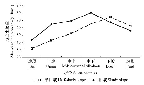
3 结果与分析 3.1 地上生物量的坡向和坡位差异图 1表明:在半阴坡,坡顶、上坡、中上坡、中下坡、下坡和坡脚的地上生物量分别为31.76,43.00,52.36,65.31,74.26和62.74 t ·hm-2,变幅为42.50 t ·hm-2,加权平均值为52.36 t ·hm-2;在阴坡,坡顶、上坡、中上坡、中下坡、下坡和坡脚的地上生物量分别为43.14,64.81,69.42,80.19,67.26和56.15 t ·hm-2,变幅为37.05 t ·hm-2,加权平均值为63.98 t ·hm-2。地上生物量在阴坡高于半阴坡,但其变幅表现为半阴坡高于阴坡。
 |
图 1 地上生物量在半阴坡和阴坡的坡位变化 Fig.1 Variation of aboveground biomass along slope position on the half-shady and shady slopes |
地上生物量在半阴坡表现为坡顶(31.76)< 上坡(43.00)< 中上(52.36)< 中下(65.31)< 坡脚(62.76)<下坡(74.26),即由坡顶向下逐渐增加,在下坡达到最大,然后随坡位继续下降降低;地上生物量在阴坡表现为坡顶(43.14)< 坡脚(56.15)<上坡(64.81)< 下坡(67.26)<中上(69.42)< 中下(80.19),其最大值出现在中下坡。
3.2 地上生物量的坡面变化坡面上样地的海拔和坡位位置不是严格地一一对应,难以进行简单对比和定量分析,因此进一步以样地离开坡顶的绝对水平距离和相对水平距离(绝对水平距离与坡面水平长度的比值)为X轴,定量分析地上生物量的坡面变化规律。图 2表明,在半阴坡和阴坡2个坡面上,地上生物量随离开坡顶的水平距离的变化趋势基本相同,都是从坡顶向下逐渐增大,都在离开坡顶水平距离约300 m时达到最高,然后在继续向下时转为降低。这个最高点的坡面相对位置在半阴坡为0.78(300 m/386 m=0.78),在阴坡为0.57(300 m/522 m=0.57),从离开坡顶的相对距离来看,只能说2个坡面上变化规律大致相同,但地上生物量最大值出现的位置在半阴坡比阴坡更低。
 |
图 2 地上生物量在半阴坡和阴坡随离开坡顶距离的变化 Fig.2 Variation of aboveground biomass along the distance from slope top on the half-shady and shady slopes |
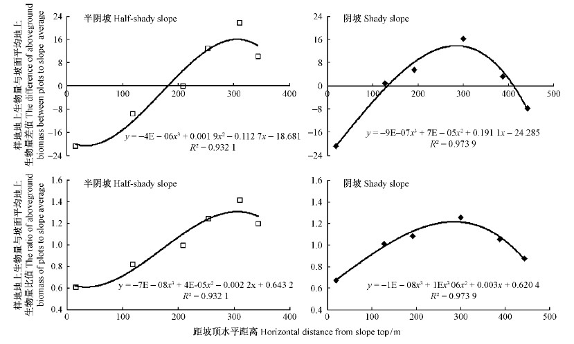
地上生物量在半阴坡和阴坡坡面都存在坡位差异,主要是由不同坡位的土壤厚度等物理性质导致的土壤养分含量和抗旱能力差异以及坡面汇流导致的水分条件差异等引起的。为了定量分析这种坡面效应,采用各样地地上生物量与坡面平均地上生物量的差值和比值进一步分析。
各样地地上生物量与坡面平均地上生物量的差值随坡面水平距离的坡面效应见图 3。在半阴坡,从坡顶到坡面水平距离180 m处,地上生物量差值持续上升且小于0,从180 m处至坡面下端,差值大于0,并在坡面水平距离300 m处达最大;在阴坡,从坡顶到坡面水平距离130 m处,差值持续上升且小于0,从130 m处至410 m处大于0,并在坡面水平距离300 m处达最大,但从300 m处到坡面下端持续下降,并在410 m处以后小于0。
 |
图 3 样地地上生物量与坡面平均地上生物量的差值和比值随距坡顶水平距离的变化 Fig.3 Variation of the difference and ratio of aboveground biomass of plots to the whole slope average along the horizontal distance from slope top on the half-shady and shady slopes |
在半阴坡,从坡顶到坡面水平距离180 m处,其值持续上升且小于1,从180 m处至坡面下端处大于1,在坡面水平距离300 m处达到最大,出现最大比值的坡位与地上生物量最大差值坡位一致;在阴坡,从坡顶到130 m处,比值持续增大并小于1,从130 m处到410 m处大于1,然后至坡面下端持续下降且小于1,在坡面水平距离300 m处达到最大,出现最大比值的坡位与地上生物量最大差值坡位一致。样地地上生物量与坡面平均地上生物量的比值(Y)随离开坡顶的相对水平距离(X,m)呈非线性变化,其关系式在半阴坡为Y=-7×10-8X3+4×10-5X2-2.2×10⁻³X+0.643 2(R2=0.932 1),在阴坡为Y=-1×10-8X3+1×10-6X2+3×10⁻³X+0.620 4(R2=0.973 9)。
3.3 地上生物量的坡面尺度效应尺度效应是在自然界广泛存在的某特征值随时间或空间尺度增大而变化的现象,掌握尺度效应可更好地调查估计相关特征值。为定量理解华北落叶松林地上生物量的坡面尺度效应,选择地上生物量滑动平均值为指标,观察其随距坡顶水平距离增加的变化(图 4)。在半阴坡,随距坡顶水平距离增加,地上生物量滑动平均值几乎呈线性逐渐增大,从31.76 t ·hm-2升到52.36 t ·hm-2,变幅为20.60 t ·hm-2,平均每100 m水平坡长使滑动平均值升高6.28 t ·hm-2;在阴坡,随距坡顶水平距离增加,地上生物量滑动平均值先快速增加,后缓慢增加,从43.14 t ·hm-2升到最大值63.98 t ·hm-2后又逐渐减小,变幅为20.84 t ·hm-2,平均每100 m水平坡长使滑动平均值升高4.92 t ·hm-2。 地上生物量的坡面滑动平均值(y,t ·hm-2)从坡顶向下随离开坡顶的相对水平距离(x,m)增加而基本表现为逐渐升高,其关系式在半阴坡为y=2×10-7x3-7×10-5x2+0.067 5x+30.838(R2=0.995 7),在阴坡为y=-2×10-7x3-8×10-5x2+0.121 9x+40.875(R2=0.999 8)。综合来看,地上生物量的坡面尺度效应在半阴坡强于阴坡。
 |
图 4 地上生物量滑动平均值随距坡顶水平距离的变化 Fig.4 Variation of moving average of aboveground biomass along the horizontal distance from slope top on the half-shady and shady slopes |
山地地形可导致光照、水分、温度、养分等的空间变化,引起植被生产力的坡向差异。如长白山分布在平坡和南坡的森林生物量共占47%,温度低为这里限制生长的主要因素,而南坡与平坡气温较高(毛学刚等,2011);Tajchman等(1996)研究了阿巴拉契亚山脉阔叶树的生物量分布,发现东坡大于西坡,主要原因是东坡立地条件好。张春梅等(2011)在延河流域研究表明,阴坡自然植被地上生物量大于半阴坡,与本研究结果相同。
在本研究中,半阴坡的坡面平均地上生物量为52.36 t ·hm-2,比阴坡(63.98 t ·hm-2)低18.16%。由于叠叠沟地处半干旱区,植被生长明显受水分限制,导致生物量坡向差异的主要原因可能是土壤水分。2012年生长季实测的0~100 cm土层的体积含水量平均值在半阴坡为26.89%,小于阴坡的28.43%。此外,生物量坡向差别还可能和阴坡土壤条件较好有关,叠叠沟的阴坡各项土壤水文物理性质均优于半阴坡(杜阿朋等,2006),植被生物量大小与土壤密度负相关(张千千等,2009)。
4.2 地上生物量坡位变化的原因本研究中,地上生物量的坡位变化表现为从坡顶向下逐渐增加,并在阴坡的中下部(或半阴坡的下部)达到最大后又逐渐减小,表明坡位对地上生物量影响较大,其主要影响因素可能是土壤水分条件的坡位差异(莫保儒等,2013;邱扬等,2001;Qiu et al.,2001;Western et al.,1999;Williams et al.,2009),并可能超过土壤厚度的坡位差异影响,因土壤厚度沿坡位下降一直增大的变化趋势与生物量坡位变化并不一致。
坡顶的土壤含水量相对较高,而2个坡面上的坡顶生物量都最低,这是因坡顶的坡度缓、径流少,加之土层薄和石砾多(杜阿朋等,2009)而造成植被生长差和耗水少,从而土壤含水量较高;从坡上部到坡下部,土壤含水量逐步升高,重要原因是坡面径流的顺坡汇集,使较低处的坡面径流损失较小或获得了更多坡面径流输入,用于支撑较大的植被生产力。在前人大多数研究(李凯辉等,2007;刘兴良等,2006;刘彦春等,2010;马维玲等,2010;魏晶等,2004)中,林分生物量随海拔升高而逐渐减小,这和本研究的生物量坡位差异不同,因前者反映的是在较大高差范围内的温度控制生长作用,本研究反映的是不同坡位水分条件的生长控制作用。
4.3 地上生物量的坡面变化分区和尺度效应依据样地地上生物量与坡面平均地上生物量的差值和比值的坡面变化,可将整个坡面划分为因径流沿坡输入而产生的“受益区”以及因径流沿坡向下输出和无径流输入而产生的 “亏缺区”。在半阴坡,受益区和亏缺区的坡段分别占整个坡长的53.4%(180~386 m)和46.6%(0~180 m),在阴坡,分别为53.6%(130~410 m)和46.4%(0~130 m和410~522 m),均表现为受益区长度大于亏缺区,且比例基本相同。此外,半阴坡的坡面效应即半阴坡样地的地上生物量坡位差值大于阴坡。
本研究中,2个坡面地上生物量的坡面滑动平均值从坡顶向下随离开坡顶的相对水平距离增加呈升高的趋势,即在坡面上存在空间尺度效应,每100 m水平坡长导致的地上生物量增加值在半阴坡为6.28 t ·hm-2,在阴坡为4.92 t ·hm-2,比半阴坡低21.66%。这是水分养分条件、土壤厚度和坡面径流再分配等多因素共同作用的结果。但对于坡面尺度效应随气候环境因素的变化以及不同地形因素在尺度效应形成中的作用及大小还需深入研究。
4.4 不同坡位样地的坡面代表性在调查或监测森林的生长量、蓄积量、生物量时,不可能在离开坡顶的所有距离都布置样地,只能通过数量有限的典型样地调查推求整个坡面的平均值。本研究表明,不同坡位样地的地上生物量与坡面平均地上生物量的比值随距坡顶相对距离的变化较大,即不同坡位样地的坡面代表性存在很大差异。定量分析不同坡位样地的坡面代表性及其沿坡面变化规律,对提高样地调查效率和坡面参数估算精度有很大帮助。
本研究确定了阴坡和半阴坡2个典型坡面上的样地地上生物量与坡面平均地上生物量的比值随距坡顶的相对水平距离的非线性变化关系。藉此可把特定坡位样地的地上生物量换算为坡面平均值,从而提高森林生物量调查的精度和效率。本研究或将来更多的类似研究结果,有助于合理划分坡段,把时常以坡面为单元的“林班”或“小班”管理提高到考虑坡位差异的“细班”管理。
本研究的不足之处在于还需调查更多坡面,设立更多重复样地,从而得到更具普遍性的规律;也还需调查更多地区,以全面理解特定样地的坡位差异及坡面代表性的区域变化规律。
| [1] |
陈德祥, 李意德, 骆土寿, 等. 2004. 海南岛尖峰岭鸡毛松人工林乔木层生物量和生产力研究. 林业科学研究, 17(5): 598-604. (Chen D X, Li Y D, Luo T S, et al. 2004. Study on Biomass and net primary productivity of Podocarpus imbricatus plantation in Jianfengling, Hainan Island. Forest Research, 17(5): 598-604[in Chinese]).(  1) 1)
|
| [2] |
杜阿朋, 王彦辉, 管伟, 等. 2009. 六盘山叠叠沟小流域的土壤石砾含量坡面分布特征. 水土保持学报, 23(5): 76-80. (Du A P, Wang Y H, Guan W, et al. 2009. Distribution of rock fragment content on slopes in the small watershed of diediegou of Liiupan Mountains. Journal of Soil and Water Conservation, 23(5): 76-80[in Chinese]).(  1) 1)
|
| [3] |
杜阿朋, 于澎涛, 王彦辉, 等. 2006. 六盘山北侧叠叠沟小流域土壤物理性质空间变异的研究. 林业科学研究, 19(5): 547-554. (Du A P, Yu P T, Wang Y H, et al. 2006. The soil physical characteristics in the small watershed of diediegou located on the north side of Liupan Mountains. Forest research, 19(5): 547-554[in Chinese]).(  1) 1)
|
| [4] |
樊后保, 李燕燕, 苏兵强, 等. 2006. 马尾松-阔叶树混交异龄林生物量与生产力分配格局. 生态学报, 26(8): 2463-2473. (Fan H B, Li Y Y, Su B Q, et al. 2006. Allocation pattern of biomass and productivity in the mixed uneven-aged stands of Masson's pine and hardwood species. Acta Ecologica Sinica, 26(8): 2463-2473[in Chinese]).(  1) 1)
|
| [5] |
黄德青, 于兰, 张耀生, 等. 2011. 祁连山北坡天然草地地上生物量及其与土壤水分关系的比较研究. 草业学报, 20(3): 20-27. (Huang D Q, Yu L, Zhang Y S, et al. 2011. Above-ground biomass and its relationship to soil moisture of natural grassland in the northern slopes of the Qilian Mountains. Acta Prataculturae Sinica, 20(3): 20-27[in Chinese]).(  1) 1)
|
| [6] |
李根, 周光益, 吴仲民, 等. 2012. 南岭小坑木荷群落地上生物量. 林业科学, 48(3): 143-147. (Li G, Zhou G Y, Wu Z M, et al. 2012. Aboveground biomass of a naturaly-regenerated Schima superba community at Xiaokeng of the Nanling Mountain. Scientia Silvae Sinicae, 48(3): 143-147[in Chinese]).(  1) 1)
|
| [7] |
李凯辉, 胡玉昆, 王鑫, 等. 2007. 不同海拔梯度高寒草地地上生物量与环境因子关系. 应用生态学报, 18(9): 2019-2024. (Li K H, Hu Y K. Wang X, et al. 2007. Relationship between aboveground biomass and environmental factors along an altitude gradient of alpine grassland. Chinese Journal of Applied Ecology, 18(9): 2019-2024[in Chinese]).(  1) 1)
|
| [8] |
刘国华, 马克明, 傅伯杰, 等. 2003. 岷江干旱河谷主要灌丛类型地上生物量研究. 生态学报, 23(9): 1757-1764. (Liu G H, Ma K M, Fu B J, et al. 2003. Aboveground biomass of main shrubs in dry valley of Minjiang River. Acta Ecologica Sinica, 23(9): 1757-1764[in Chinese]).(  1) 1)
|
| [9] |
刘兴良, 刘世荣, 宿以明, 等. 2006. 巴郎山川滇高山栎灌丛地上生物量及其对海拔梯度的响应. 林业科学, 42(2): 1-7. (Liu X L, Liu S R, Su Y M, et al. 2006. Aboveground biomass of Quercus aquifolioides shrub community and its responses to altitudinal gradients in Balangshan Mountain, Shichuan Province. Scientia Silvae Sinicae, 42(2): 1-7[in Chinese]).(  1) 1)
|
| [10] |
刘彦春, 张远东, 刘世荣, 等. 2010. 川西亚高山针阔混交林乔木层生物量、生产力随海拔梯度的变化. 生态学报, 30(21): 5810-5820. (Liu Y C, Zhang Y D, Liu S R, et al. 2010. Changes of tree layer aboveground biomass, ANPP to altitudinal gradient in the subalpine secondary of Western Sichuan, China. Acta Ecologica Sinica, 30(21): 5810-5820[in Chinese]).(  1) 1)
|
| [11] |
刘延惠, 王彦辉, 于澎涛, 等. 2011. 六盘山主要植被类型的生物量及其分配. 林业科学研究, 24(4): 443-452. (Liu Y H, Wang Y H, Yu P T, et al. 2011. Biomass and its allocation of the main vegetation types in Liupan Mountains. Forest Research, 24(4): 443-452[in Chinese]).(  1) 1)
|
| [12] |
吕晓涛, 唐建维, 何有才, 等. 2007. 西双版纳热带季节雨林的生物量及其分配特征. 植物生态学报, 31(1): 11-22. (Lü X T, Tang J W, He Y C, et al. 2007. Biomass and its allocation in tropical seasonal rain forest in Xishuangbanna, southwest China. Chinese Journal of Plant Ecology, 31(1): 11-22.(  1) 1)
|
| [13] |
马维玲, 石培礼, 李文华, 等. 2010. 青藏高原高寒草甸植株性状和生物量分配的海拔梯度差异. 中国科学: 生命科学, 40(6): 533-543. (Ma W L, Shi P L, Li W H, et al. 2010. The change of individual plant traits and biomass allocation in alpine meadow with elevation variation on the Qinghai-Tibetan Plateau. Scientia Sinica Vitae, 40(6): 533-543[in Chinese]).(  1) 1)
|
| [14] |
马文红, 方精云, 杨元合, 等. 2010. 中国北方草地生物量动态及其与气候因子的关系. 中国科学: 生命科学, 40(7): 632-641. (Ma W H, Fang J Y, Yang Y H, et al. 2010. Biomass carbon stocks and their changes in northern China's grasslands during 1982-2006. Scientia Sinica Vitae, 40(7): 632-641[in Chinese]).(  1) 1)
|
| [15] |
毛学刚, 范文义, 李明泽, 等. 2011. 黑龙江长白山森林生物量的时空变化分析. 植物生态学报, 35(4): 371-379. (Mao X G, Fan W Y, Li M Z, et al. 2011. Temporal and spatial analysis of forest biomass in Changbai Mountains, Heilongjiang, China. Chinese Journal of Plant Ecology, 35(4): 371-379[in Chinese]).(  1) 1)
|
| [16] |
明安刚, 贾宏炎, 陶怡, 等. 2012. 桂西南28年生米老排人工林生物量及其分配特征. 生态学杂志, 31(5): 1050-1056. (Ming A G, Jia H Y, Tao Y, et al. 2012. Biomass and its allocation in a 28-year old Mytilaria laosensis plantation in southwest Guangxi. Chinese Journal of Ecology, 31(5): 1050-1056[in Chinese]).(  1) 1)
|
| [17] |
莫保儒, 蔡国军, 杨磊, 等. 2013. 半干旱黄土区成熟柠条林地土壤水分利用及平衡特征. 生态学报, 33(13): 4011-4020. (Mo B R, Cai G J, Yang L, et al. 2013. Soil water use and balance characteristics in mature forest land profile of Caragana korshinskii in Semiarid Loess Area. Acta Ecologica Sinica, 33(13): 4011-4020[in Chinese]).(  1) 1)
|
| [18] |
漆良华, 张旭东, 周金星, 等. 2007. 马尾松飞播林生物量与生产力的变化规律与结构特征. 林业科学研究, 20(3): 344-349. (Qi L H, Zhang X D, Zhou J X, et al. 2007. Changing regularities and structural characteristics of the biomass and productivity of aerially seeded Pinus massoniana plantation. Forest Research, 20(3): 344-349[in Chinese]).(  1) 1)
|
| [19] |
邱扬, 傅伯杰, 王军, 等. 2001. 黄土丘陵小流域土壤水分的空间异质性及其影响因子. 应用生态学报, 12(5): 715-720. (Qiu Y, Fu B J, Wang J, et al. 2001. Spatial heterogeneity of soil moisture content on the Loess Plateau China and its relation to influencing factors. Chinese Journal of Applied Ecology, 12(5): 715-720[in Chinese]).(  1) 1)
|
| [20] |
王建国, 樊军, 王全九, 等. 2011. 黄土高原水蚀风蚀交错区植被地上生物量及其影响因素. 应用生态学报, 22(3): 556-564. (Wang J G, Fan J, Wang Q J, et al. 2011. Vegetation above-ground biomass and its affecting factors in water/wind erosion crisscross region on Loess Plateau. Chinese Journal of Applied Ecology, 22(3): 556-564[in Chinese]).(  1) 1)
|
| [21] |
魏晶, 吴刚, 邓红兵. 2004. 长白山高山冻原植被生物量的分布规律. 应用生态学报, 15(11): 1999-2004. (Wei J, Wu G, Deng H B. 2004. Vegetation biomass distribution characteristics of alpine tundra ecosystem in Changbai Mountains. Chinese Journal of Applied Ecology, 15(11): 1999-2004[in Chinese]).(  1) 1)
|
| [22] |
张春梅, 焦峰, 温仲明, 等. 2011. 延河流域自然与人工植被地上生物量差异及其土壤水分效应的比较. 西北农林科技大学学报: 自然科学版, 39(4): 132-138. (Zhang C M, Jiao F, Wen Z M, et al. 2011. Differences of above-ground biomass and comparisons of its effect on soil moisture between natural vegetation and artificial vegetation in Yanhe basin. Journal of Northwest A&F University: Nat. Sci. ED., 39(4): 132-138[in Chinese]).(  2) 2)
|
| [23] |
张国斌, 李秀芹, 佘新松, 等. 2012. 安徽岭南优势树种(组)生物量特征. 林业科学, 48(5): 136-140. (Zhang G B, Li X Q, She X S, et al. 212. Biomass characteristics of dominant tree species (Group) at Lingnan Forest Farm in Anhui Province. Scientia Silvae Sinicae, 48(5): 136-140[in Chinese]).(  1) 1)
|
| [24] |
张千千, 王彦辉, 缪丽萍, 等. 2009. 六盘山叠叠沟小流域草本地上生物量的空间变化及其与环境因子的关系. 中国农学通报, 25(04): 82-87. (Zhang Q Q, Wang Y H, Miao L P, et al. 2009. Spatial variation of above-ground biomass of grasses and its relation with environmental factors in the small watershed of diediegou of Liupan Mountains. Chinese Agricultural Science Bulletin, 25(04): 82-87[in Chinese]).(  1) 1)
|
| [25] |
Browm S L, Schroeder P, Kern J S. 1999. Spatial distribution of biomass in forests of the eastern USA. Forest Ecology and Management, 123(1): 81-90.( 1) 1)
|
| [26] |
Genet A, Wemsdorfer H, Jonard M, et al. 2011. Ontogeny partly explains the apparent heterogeneity of published biomass equations for Fagus sylvatica in central Europe. Forest Ecology and Management, 261(7): 1188-1202.( 1) 1)
|
| [27] |
Hui D F, Wang J, Le X, et al. 2012. Influences of biotic and abiotic factors on the relationship between tree productivity and biomass in China. Forest Ecology and Management, 264: 72-80.( 1) 1)
|
| [28] |
Mokany K, Raison R J, Prokushkin A. 2006. Critical analysis of root: shoot ratios in terrestrial biomes. Global Change Biology, 12(1): 84-96.( 1) 1)
|
| [29] |
Qiu Y, Fu B J, Wang J, et al. 2001. Spatial variability of soil moisture content and its relation to environmental indices in a semi-arid gully catchment of the Loess Plateau, China. Journal of Arid Environments, 49(4): 723-750.( 1) 1)
|
| [30] |
Tajchman S, Benyon R, Bren L, et al. 1996. On spatial variability of Above-ground Forest Biomass. Biomass and Bioenergy, 11(5): 383-386.( 1) 1)
|
| [31] |
Tritton L M, Martin C W, Hombeck J W. 1987. Biomass and nutrient removals from commercial thinning and whole-tree clear cutting of central hardwoods. Environmental Management, 11(5): 659-666.( 1) 1)
|
| [32] |
Wen Y G, Chen F, Liu S R, et al. 2009. Relationship between species diversity and biomass of eucalyptus plantation in Guangxi, south China. Frontiers of Forestry in China, 4(2): 146-152.( 1) 1)
|
| [33] |
Western A W, Grayson R B, Bloschl G, et al. 1999. Observed spatial organization of soil moisture and its relation to terrain indices. Water Resource Research, 35(3): 797-810.( 1) 1)
|
| [34] |
Williams C J, Mcnamara J P, Chandler D G. 2009. Controls on the temporal and spatial variability of soil moisture in a mountainous landscape: the signature of snow and complex terrain. Hydrology and Earth System Sciences, 13(7): 1325-1336.( 1) 1)
|
 2015, Vol. 51

