
Carbon Storage Dynamics in Lower Shimentan Formation of the Qiantang Sag, East China Sea Shelf Basin: Stratigraphy, Reservoir-Cap Analysis, and Source-Sink Compatibility
https://doi.org/10.1007/s11804-024-00562-8
-
Abstract
Excessive carbon emissions have resulted in the greenhouse effect, causing considerable global climate change. Marine carbon storage has emerged as a crucial approach to addressing climate change. The Qiantang Sag (QTS) in the East China Sea Shelf Basin, characterized by its extensive area, thick sedimentary strata, and optimal depth, presents distinct geological advantages for carbon dioxide (CO2) storage. Focusing on the lower section of the Shimentan Formation in the Upper Cretaceous of the QTS, this study integrates seismic interpretation and drilling data with core and thin-section analysis. We reveal the vertical variation characteristics of the strata by providing a detailed stratigraphic description. We use petrophysical data to reveal the development characteristics of high-quality carbon-storage layers and favorable reservoir-caprock combinations, thereby evaluating the geological conditions for CO2 storage in various stratigraphic sections. We identify Layer B of the lower Shimentan Formation as the most advantageous stratum for marine CO2 storage. Furthermore, we analyze the carbon emission trends in the adjacent Yangtze River Delta region. Considering the characteristics of the source and sink areas, we suggest a strong correlation between the carbon emission sources of the Yangtze River Delta and the CO2 storage area of the QTS, making the latter a priority area for conducting experiments on marine CO2 storage.-
Keywords:
- Carbon storage ·
- Qiantang Sag ·
- Reservoir-cap ·
- Source-sink dynamics ·
- East China Sea Shelf Basin
Article Highlights• The study investigates the carbon storage potential in the Lower Shimentan Formation within the Qiantang Sag, East China Sea Shelf Basin.• Stratigraphic and reservoir-cap rock assessments evaluate the geological suitability for CO2 storage.• The compatibility between carbon sources and sinks is analyzed to determine effective storage strategies.• Results highlight the critical role of stratigraphy and reservoir characteristics in influencing carbon storage capacity and efficiency. -
1 Introduction
Global warming and consequent greenhouse effect pose a notable climatic challenge, with carbon emissions identified as a primary cause (Plass, 1956; Manabe and Wetherald, 1967, 1975; Fleming, 1998; Gao et al., 2001; Feng and Fu, 2007; Shepardson et al., 2011; Freudenburg and Muselli, 2013; Wang et al., 2014; Chai and Xu, 2014; Cook et al., 2016; Mandal et al., 2021). In response, global efforts to reduce carbon dioxide (CO2) emissions have intensified, culminating in notable international treaties such as the United Nations Framework Convention on Climate Change (UNFCCC) (Bian et al., 2011). The "Sunnylands Statement on Enhancing Cooperation to Address the Climate Crisis, " issued by China and the United States in 2023, emphasizes a shared commitment toward addressing the climate crisis through effective implementation of UNFCCC and the Paris Agreement, aiming to limit the global temperature increase and promote cooperative carbon capture, usage, and storage (CCUS) projects (Xie and Kerry, 2023).
CCUS has been recognized as a pivotal strategy for achieving carbon neutrality and mitigating global climate change, highlighted by the Intergovernmental Panel on Climate Change (IPCC)'s "Special Report on Carbon Capture and Storage" and subsequent studies (Metz, 2005; Haszeldine et al., 2018; IPCC, 2018, 2022; Li et al., 2023a). Moreover, the opinions of the CPC central committee and the state council on accelerating carbon peak and carbon neutralization endorse CCUS as a crucial technological approach toward China's dual carbon target, promoting its development across various sectors.
In CCUS, "storage" refers to the process of transporting CO2, which has been separated from industrial emissions using carbon capture technology, to locations such as underground or subseabed for deposition. The principal methods of storage encompass geological storage, oceanic storage, and chemical storage (Van Der Burgt, 1992; Holloway, 1997; Oldenburg et al., 2000; Bachu, 2000; Mamora and Seo, 2002; Orr, 2004; Sim et al., 2008; Jang et al., 2010; Li, 2011; Peckham, 2014; Group, 2015; Cai et al., 2021; Hu et al., 2023).
From a geological perspective, CO2 storage is categorized into terrestrial and marine carbon storage on the basis of the location of storage sites. In China, several terrestrial sites, including the Ordos Basin, Songliao Basin, and Subei Basin, are considered appropriate for storage (Sun et al., 2021). However, in provinces such as Jiangsu, Zhejiang, and Guangdong along China's eastern coast, where CO2 emissions are high, it is challenging to find appropriate terrestrial storage sites nearby that meet all necessary conditions. While basins such as the Subei Basin on land could provide storage solutions for these coastal areas, their feasibility is constrained by factors such as high population density, scarcity of land resources, and concentration of notable infrastructure projects, increasing the safety risks associated with carbon storage in these regions (Chen et al., 2023). However, marine basins near China, such as the Bohai Basin, Southern Yellow Sea Basin, East China Sea (ECS) Shelf Basin, and Pearl River Mouth Basin, are in close proximity to the mainland. These basins have been the topic of extensive foundational research related to marine carbon storage. In recent years, many scholars have highlighted the advantages of marine carbon storage, such as large storage potential, high safety, minimal environmental impact, and long storage duration, all of which are difficult to match by terrestrial storage (Huo et al., 2014; Zhang et al., 2012) Among the major sedimentary basins in China's offshore areas, the ECS Shelf Basin, located near the Yangtze River Delta, ranks high in terms of suitability for submarine carbon storage. Furthermore, the Taibei Depression is recognized as the unit with the highest comprehensive suitability for CO2 storage within the ESC Basin (Ke et al., 2023). Noteworthily, the Qiantang Sag (QTS) is a constituent of the Taibei Depression.
The QTS, as one of the marine sedimentary basins with high suitability for carbon storage, is located in close proximity to China's primary carbon emission zone, the Yangtze River Delta region. This geographical advantage is unparalleled by other marine basins. However, foundational geological research on the QTS, as well as studies on its potential for geological carbon storage, are notably scarce. In fact, research on the QTS is often discussed within the broader context of the ESC Shelf Basin (Chen et al., 2003; Zhao, 2005; Xia, 2012; Liang et al., 2016; Zhong et al., 2018, 2019; Zhang et al., 2015; Zhao, 2019; Yang et al., 2022). In addition, while some studies have briefly examined the structural environment surrounding the QTS (Jiang et al., 2016, 2020; Tang et al., 2018), research focused on the QTS remains relatively limited, particularly in terms of investigations targeting its Mesozoic sedimentary layers. Thus, we must conduct high-precision stratigraphic studies and investigate the reservoir-caprock combinations to promote research on marine CO2 storage in this strategically important area.
2 Regional geological conditions
The ESC Shelf Basin is the largest Mesozoic-Cenozoic superimposed basin in China's offshore areas. Some scholars suggest that this basin is situated within the thinning lithosphere of the West Pacific Triangle Zone, forming a notable convergent zone at which the Indo-Australian Plate and Pacific Plate meet the Eurasian Plate. The basin's eastern and western sides are, respectively, linked to the evolution of the Tethys tectonic domain and West Pacific tectonic domain (Li et al., 2013; Faccenna et al., 1996), constituting an important part of the Western Pacific continental margin system. In the recent years, numerous domestic and international scholars have extensively researched various aspects such as the tectonic evolution and sedimentary characteristics of this basin, gaining many new insights. This has established the basin as one of the most extensively studied regions in China's offshore areas (Hall, 2002; Lin et al., 2003; Chen et al., 2003; Zhao, 2005; Lee et al., 2006; Zhu and Mi, 2010; Zhu et al., 2019, 2022b; Ding et al., 2017; Wang et al., 2012; Xia, 2012; Yang et al., 2013, 2022; Suo et al., 2015; Liang et al., 2016; Jiang et al., 2016, 2020; Xu et al., 2017; Zhong et al., 2018, 2019; Zhang et al., 2015; Tang et al., 2018; Zhao, 2019; Fu et al., 2022; Xu et al., 2023).
The ESC Shelf Basin covers an area of 267 000 km2 and extends ~1 100 km from north to south and 325- 500 km from east to west. Overall, it is oriented in the NNE direction, geographically bounded by the Ryukyu Uplift and the Zhe-Min Uplift structural units to the east and west, respectively. From west to east, the basin is divided into three primary structural units, namely the Western Depression Belt, Central Uplift Belt, and Eastern Depression Belt, and seven secondary structural units. The Western Depression Belt includes the following tertiary units: the Yangtze Depression, the Taibei Depression, and the Pengjia Island Depression (Zhong et al., 2019).
The QTS is located within the Taibei Depression of the Western Depression Belt, specifically to the southwest of the Haijiao Uplift. To the south, it adjoins the boundary of the Yushandong Uplift, transitions to the Haijiao Uplift in the north, lies adjacent to the Zhe-Min Uplift zone in the west, gradually transitions to the Xihu Sag in the east, and connects with the Jiaojiang Sag in the southwest (Figure 1) (Zhao, 2005).
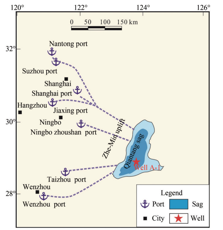 Figure 1 Regional location map of the Qiantang Sag (QTS) (location references from Lin et al. (2003); Zhu et al. (2010, 2019); Feng et al. (2024))
Regarding sedimentary strata and basin types, the QTS is filled with Mesozoic-Cenozoic sedimentary strata and might also contain Paleozoic strata. The sag exhibits a distinct double-fault structure, classifying it as a rift basin that has experienced a prolonged subsidence process (Zhao, 2005; Xia, 2012).
3 Method and data
3.1 Basin scale and stratigraphic suitability
We reviewed previous studies and regional maps to evaluate whether the size of the sedimentary basin meets the criteria required for carbon storage potential. Further, we employed seismic profile interpretation to assess if the thickness of the basin's sedimentary strata meets the conditions necessary for carbon storage. The seismic data were analyzed at the Center for Marine Resources, Tongji University. Key stratigraphic reflection interfaces on seismic lines passing through Well A-1 were identified and marked on the basis of a stratigraphic division scheme. These markers facilitated the tracking of the extension of strata. The distribution of strata from different periods within the QTS was revealed via the integration of the well and seismic data (Al-Masgari et al., 2021).
3.2 Key stratigraphic geological characteristics
The study primarily focused on the lithologic sequence derived from drilling at the only well, i.e., Well A-1, in the QTS, supplemented by some microscopic thin section and core observations. This approach was to clarify the petrological characteristics and lithological variations of this stratigraphic segment, inferring the characteristics of its depositional facies.
The thin-section samples were pretreated at the Key Laboratory of Marine Geology, Tongji University. Prior to preparing the thin sections, the samples were thoroughly washed with pure water to eliminate any mud interference and then dried using a dryer. After drying, the samples were left unstained and prepared into 50- μm microscopic thin sections according to the rock thin-section identification standard SY/T 5368-2016. Observations were made using an Mshot MP41 professional polarizing microscope, with a particular focus on unique lithological thin sections.
3.3 Carbon storage layers and caprocks
In the context of geophysical well logging, interpretation of specific parameters is fundamental to assessing the quality of a reservoir and determining its carbon storage capacity (Dashtian et al., 2011; Ning et al., 2013; Grana et al., 2017). Gamma Ray (GR) logging, which is used to measure rock radioactivity, is crucial for identifying rock types and depositional environments. These elements indicate heterogeneity and potential storage zones of a reservoir, laying the groundwork for detailed analysis. Spontaneous potential logging offers critical insights into pore fluid characteristics and rock permeability, essential for evaluating a reservoir's capacity to secure and maintain carbon deposits. Furthermore, the borehole diameter was assessed via caliper (CAL) logging, providing vital evaluations of wellbore stability, a key factor in preserving the integrity of carbon storage sites. Density (DEN) logging is crucial in deducing mineral composition and porosity, which are directly linked to the reservoir's storage capability and the integrity of the seal. Collectively, these logging parameters create a comprehensive framework, allowing for a thorough assessment of the quality of the reservoir and suitability thereof for effective carbon storage, integrating geological characteristics with geophysical data to identify high-quality carbon-storage layers and caprocks with optimal continuity.
3.4 Carbon source-sink compatibility
The study systematically compiled and analyzed carbon emission data from the Yangtze River Delta region to examine growth trends and spatial distribution. This analysis included a detailed evaluation of the alignment between carbon emissions from industrial and urban activities in the Yangtze River Delta and the geological carbon storage potential identified in the QTS. The compatibility between the carbon sources and sinks in the region, as reported by studies on carbon storage source- sink matching and economic impacts (Sun and Chen, 2022; Sun et al., 2024), along with foundational assessments of carbon capture and storage potential (Carneiro et al., 2011), emphasizes the importance of integrating economic and geological considerations. By correlating these findings with the geographical position of the QTS and its geological potential for carbon storage, this assessment aimed to identify synergies that could optimize the utilization of the QTS as a carbon sink, thereby contributing to regional carbon management strategies.
4 Results and discussion
4.1 Geological conditions for carbon storage
4.1.1 Basin and stratigraphic characteristics
The size of a sedimentary basin is a critical indicator in evaluating its suitability for marine geological CO2 storage (Chen et al., 2023; Ke et al., 2023). Depressions with an area exceeding 250 km2 are considered viable candidates for CO2 storage. The QTS, with a total area exceeding 10 000 km2, considerably surpasses this criterion, making it an ideal large-scale sedimentary depression for marine geological carbon storage.
The thickness of sedimentary strata is also a key determinant in evaluating suitability for marine geological CO2 storage. For similar fundamental geological conditions, thicker sedimentary layers represent the higher potential for geological CO2 storage (Figure 2) (Chen et al., 2023; Ke et al., 2023).
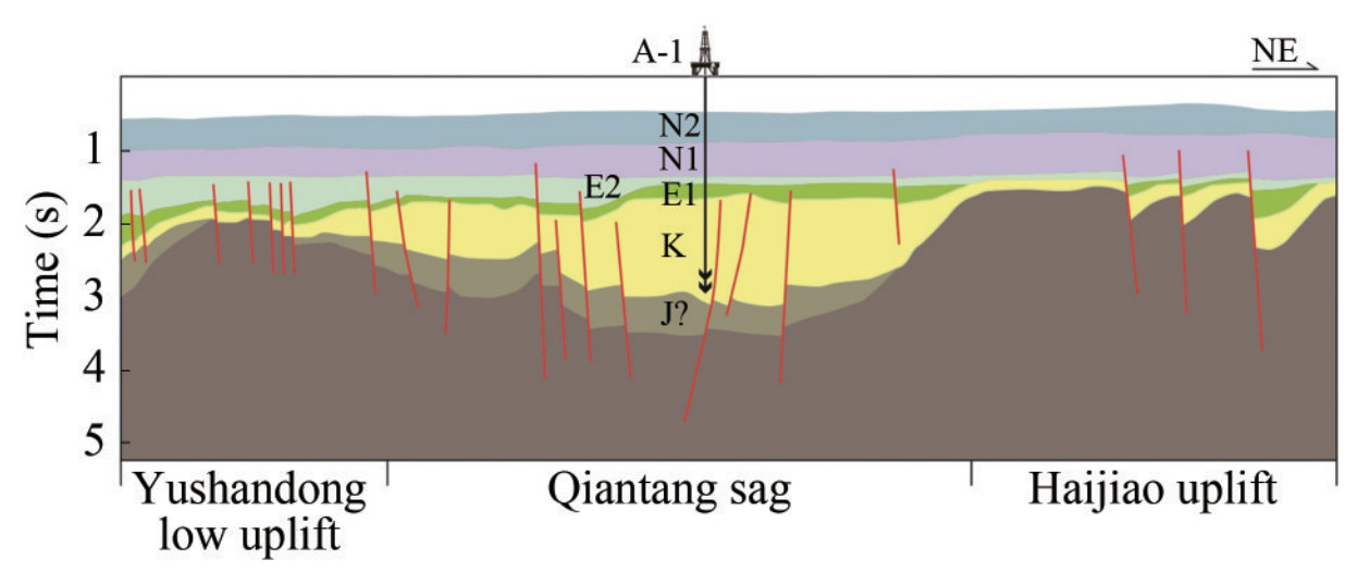 Figure 2 Seismic geological Interpretation profile through the Yushan Dong uplift-Qiantang Sag-Haireef Uplift
The QTS is characterized by its substantially thick sedimentary strata, predominantly composed of Mesozoic deposits, followed by Paleocene and Eocene formations from the Cenozoic era (Zhao, 2005; Xia, 2012; Zhong et al., 2019; Feng et al., 2024). Well A-1, a hydrocarbon exploratory well in the central part of the QTS, reaches a total depth of 4 501 m. This well has specifically revealed that the Mesozoic and Cenozoic sedimentary layers alone are up to 3 600 m thick. Seismic profile interpretations suggest unencountered Jurassic strata in the QTS. We can infer that the total sedimentary thickness in the central part of the QTS may exceed 4 000 m, indicating exceptionally favorable stratigraphic conditions.
In addition, the depth of the sedimentary strata plays an important role in the effectiveness of geological CO2 storage. Strata located at depths less than 800 m are unlikely to achieve the temperature and pressure conditions necessary for supercritical CO2 storage. Conversely, the porosity and permeability of sedimentary layers tend to diminish at depths exceeding 3 200 m, resulting in increased challenges and costs associated with CO2 injectability (Chen et al., 2023; Ke et al., 2023).
In this study, the lower section of the Shimentan Formation of the Upper Cretaceous, with a depth range of 1 987-2 210 m, falls within the optimal depth range for marine CO2 storage. Therefore, this study has selected this stratum as the target layer for carbon storage.
The lower section of the Shimentan Formation in the Upper Cretaceous has a total thickness of 223 m and lies above the Minjiang Formation of the Upper Cretaceous. This sedimentary sequence is characterized by terrestrial deposits, predominantly consisting of fluvial-lacustrine sediments. We speculate that it represents a cyclical vertical stacking of deltaic-arid lake environments composed of mudstone, silty mudstone, siltstone, and sandstone in a fining upward sequence. However, the sedimentary cycles may have been considerably altered because of the proximity of the sediment source and the abundance of coarse detrital supply (Figure 3).
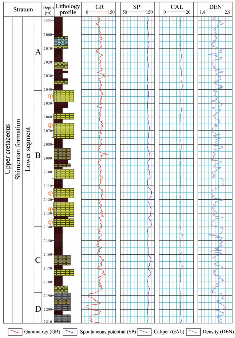 Figure 3 Comprehensive geological columnar diagram of the lower Shiementan Formation in the upper cretaceous system, QTS
In light of the characteristics of the Mesozoic strata in the QTS, as revealed by analysis of Well A-1, and considering the features of the lithological combinations, the lower section of the Shimentan Formation can be further subdivided into four layers, A, B, C, and D (Figure 3) according to variations in lithology.
The first layer, "Layer A, " spans a depth of 1 987.00-2 041.00 m with a thickness of 54.0 m. The primary lithological assemblage comprises brownish mudstone, silty mudstone, gray silty mudstone interbedded with off-white siltstone, and light gray argillaceous siltstone (Figure 4). The siltstone within this layer is characterized by high mud content and is cemented by kaolinite, resulting in relatively loose texture. The mudstone predominantly exhibits a brownish hue, with intermittent silty components, indicating these are not pure mudstones and possess a softer nature.
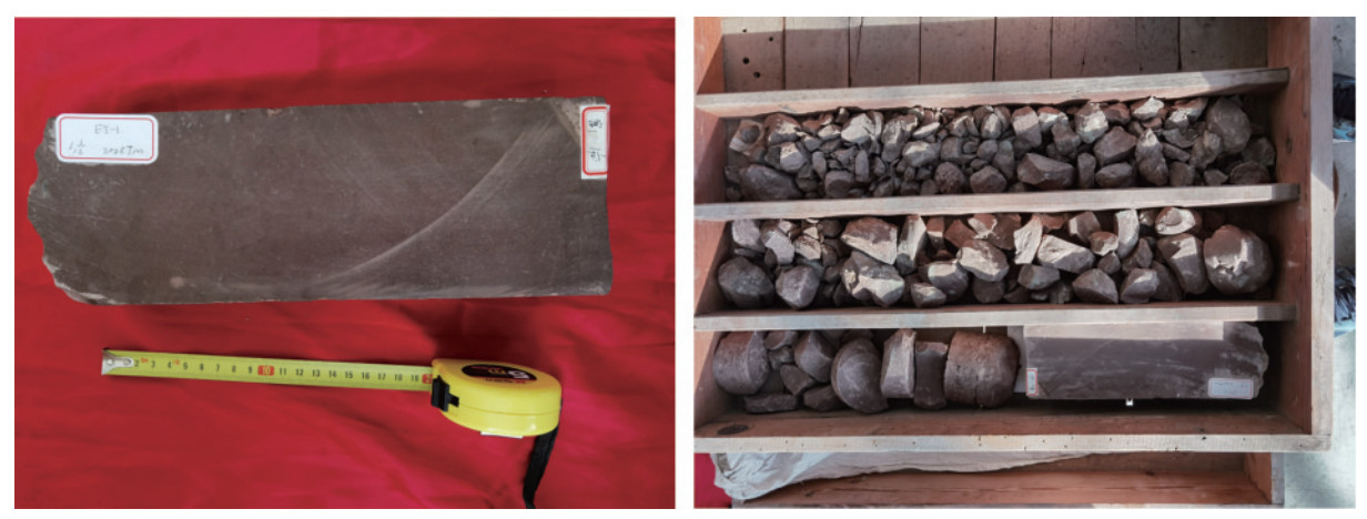 Figure 4 Well A-1: Brownish Mudstone, Muddy Siltstone, 2 027 m
Layer B, with a depth ranging from 2 041.00 to 2 140.00 m with a thickness of 99.0 m, is primarily composed of light gray fine sandstone, grayish-white siltstone, and brown muddy siltstone in an even-thickness interlayering. The fine sandstone developed in this layer is primarily quartz, followed by feldspar and dark minerals, exhibiting satisfactory sorting, subrounded abrasion, and clay cementation, affording it a loose texture. The mudstone, predominantly brown, is purer in mud content and softer.
Layer C extends from 2 140.00 to 2 188.00 m deep, with a thickness of 48.0 m. The upper part is brownish mudstone, while the lower part develops interlayers of grayish-white siltstone, light gray fine sandstone, muddy siltstone, and brownish mudstone. The fine sandstone in this layer is similar to that in Layer B. The siltstone in this layer is rich in mud, has kaolinite cementation, and is loose in texture. The mudstone is mainly brown, purer in mud content and softer.
Layer D, at a depth of 2 188.00-2 210.00 m and with a thickness of 22.0 m, predominantly comprises green-gray altered basalt interbedded with light gray siltstone and brownish mudstone (Figure 5). The altered basalt developed in this layer exhibits a porphyritic structure with irregularly distributed, automorphic, elongated microcrystalline plagioclase (clayized), and the interstices are filled with pyroxene (dolomitized) grains and magnetite. It is in pseudoconformable contact with the underlying strata.
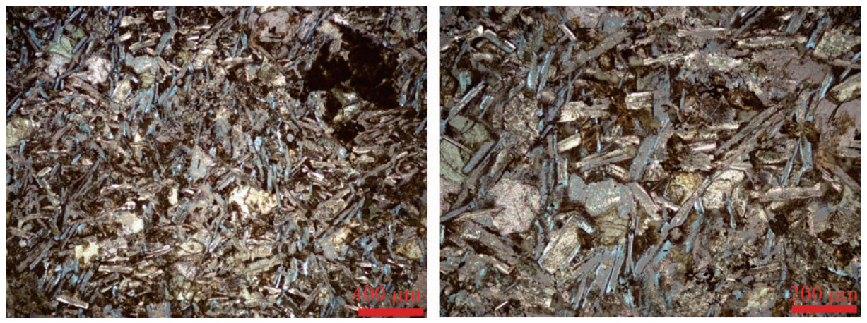 Figure 5 A-1well, microscopic photograph of Altered Basalt
4.1.2 Carbon storage layers and caprocks
Evaluating the suitability of a basin for marine geological CO2 storage critically depends on reservoir-caprock combination, encompassing caprock lithology, thickness, distribution continuity, and porosity and permeability of the reservoir. Caprock integrity is vital for storage, as the geological properties and mechanical stability of cap rocks are crucial in preventing CO2 leakage (Shukla et al., 2011). Moreover, the selection of optimal reservoir-caprock combinations for CO2 storage requires comparative analysis based on safety, storage capacity, and efficiency (Rasool et al., 2023). However, the identification of suitable combinations poses considerable challenges, provided the complexities of ensuring long-term storage integrity and mitigating environmental impacts (Aminu et al., 2017). These considerations are key to determining if a sedimentary stratum can serve as a viable site for storing geological CO2. While unsuitable combinations are characterized by poor conditions, discontinuity, and breaches in either the reservoir or cap layer, suitable ones are characterized by moderate-to-good conditions and a continuous link between the reservoir and caprock.
As per the well log data, the lower section of the Shimentan Formation is characterized by the development of multiple sets of sandstone reservoirs (Figure 3). We selected five representative sandstone strata from within this target formation, aiming to elucidate several key parameters, including porosity, permeability, and sand content (Table 1).
Table 1 Physical properties of sandstone layers ①-⑤, data derived from well A-1 logging data (Zhao, 2005)Number Depth Thickness (m) Permeability (%) Oil saturation (%) Porosity (10-3 μm2) Mud content Sand content ① 2 040.4-2 048.8 8.4 19.392 2.321 15.087 21.188 63.726 ② 2 056.5-2 075.3 18.8 28.520 1.562 16.446 15.382 68.172 ③ 2 112.2-2 119.0 6.8 55.900 4.835 19.776 12.887 67.337 ④ 2 122.4-2 132.4 10.0 21.145 0.361 15.367 25.910 58.723 ⑤ 2 134.6-2 140.0 5.4 47.427 6.837 18.884 15.989 65.127 The data analysis results revealed that the sandstone reservoirs within the lower section of the Shimentan Formation possess favorable petrophysical characteristics, with porosity levels in the range of 15×10-3-20×10-3 μm2 and permeability between 19% and 56%. Notably, two sandstone layers developed in Layer B have permeabilities of 55.9% and 47.427%, respectively (Figure 6, Table 1). Core sample analysis results indicated that the sandstones in the lower section of the formation are relatively loose and well sorted. Consequently, with the development of multiple thick sandstone layers suitable for carbon storage, this stratigraphic section exhibits remarkable sandstone reservoir conditions, classified as Class Ⅰ and Ⅱ.
 Figure 6 Three-dimensional Bar Graph of Porosity and Permeability in Sandstone Layers ①-⑤
As per the drilling data from Well A-1 in the QTS, mudstone primarily develops in the Shimentan and Minjiang formations within this region, accounting for 40%-60% of the stratigraphic sections. However, the development of mudstone in other stratigraphic layers is comparatively less prominent. Notably, the mudstones in Layer A are impure, containing partial silty elements (Figure 4), whereas those in Layers B and C are of higher purity, with the mudstones in Layer B being particularly ideal in terms of cap rock conditions, exhibiting continuous cycles and thicker layers. This suggests that cap rock conditions in the lower section of the Shimentan Formation are relatively favorable.
From the perspective of reservoir-caprock combinations, this stratigraphic section is characterized by the continuous development of multiple sets of mudstone-sandstone associations (Figure 3). In particular, Layer B, which enjoys the most advantageous storage conditions, features six sets of these combinations. Furthermore, the CAL curve of Layer B does not considerably fluctuate, indicating that this segment of the stratum possesses relatively superior continuity and stability. In contrast, Layer D is primarily composed of basalt strata, lacking favorable reservoir-cap conditions (Figure 5). However, it presents potential as a study topic for basalt mineralization carbon storage, warranting further research.
4.2 Carbon source-sink compatibility
An important factor affecting the feasibility of CO2 storage is the potential for a strong source-sink relationship between the carbon emission sources and carbon storage area. The QTS is adjacent to China's Yangtze River Delta region, forming a favorable source- sink relationship with its carbon emission sources (Figure 1). The Yangtze River Delta, China's largest urban agglomeration, primarily includes 41 cities across Shanghai, Jiangsu Province, Zhejiang Province, and Anhui Province. It is also the world's sixth-largest urban area and most economically developed region in China, making it the region with the highest carbon emissions in the country (Fan et al., 2020; Zhu et al., 2022a; Li et al., 2023b). The carbon emissions in this region extremely increased from 161.97 million tons in 2 000 to 596.99 million tons in 2020, at a growth rate of 6.74%. However, the carbon sink in the region only increased from 12.67 million tons in 2 000 to 14.58 million tons in 2020, at an annual growth rate of merely 0.70%, considerably lower than the rate of increase in carbon emissions (Li et al., 2023b) This discrepancy highlights that the carbon sink capacity in the Yangtze River Delta is considerably lower than its carbon emissions. Achieving the carbon neutrality target by 2 060 will be challenging without timely and effective CO2 storage measures.
Delta from 2000 to 2020 (Data Derived from Li et al. (2023a)) From the spatial distribution of carbon emissions in the Yangtze River Delta region (Li et al., 2023b), one can clearly see that the coastal and riverside areas, represented by cities such as Shanghai, Suzhou, Nantong, and Ningbo, exhibit considerably higher levels of carbon emissions compared with other areas. This pattern highlights a pronounced need for marine CO2 storage in these regions.
The Yangtze River Delta region enjoys comprehensive infrastructure, which includes dense networks of highways, railways, and electrical grids. In terms of port and shipping facilities, which are highly relevant for the storage of marine CO2, the region houses two of the world's leading ports: Shanghai Port and Ningbo-Zhoushan Port. In addition, the region features several large seaports, such as Jiaxing Port, Wenzhou Port, Taizhou Port, and Lianyungang Port, along with notable inland river ports such as Suzhou Port, Nantong Port, and Nanjing Port (Mou et al., 2020; Zhou, 2023). These ports are large in scale and have extensive shipping networks, providing an exceptional foundation for implementing initiatives for marine CO2 storage (Figure 1).
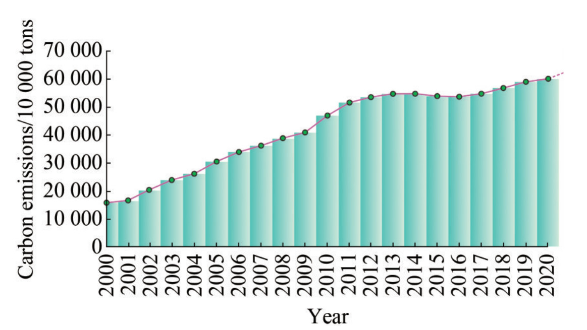 Figure 7 Changes in carbon emissions in the Yangtze River
As an example, let us discuss the CO2 transport ship ordered by Norway's Northern Lights project. This vessel is ~130 m in length, with a breadth of 21.2 m and a draft of 8 m, enabling it to easily dock at the major ports in the Yangtze River Delta region.
The QTS is a depression nearest to the main carbon emission area and crucial hub ports of the Yangtze River Delta within the ESC Shelf Basin, located within a distance of 80-200 km. The most proximate is the Ningbo-Zhoushan Port, the world's largest port. Furthermore, the average water depth in the QTS area is less than 100 m. Provided that the preferred operational depth for China's offshore oil engineering activities is within 200 m, this geographical positioning offers considerable advantages for undertaking marine CO2 storage projects.
5 Conclusions
1) The QTS in the ECS Shelf Basin enjoys several advantages for marine CO2 storage, including a large depression area, thick sedimentary layers, relatively shallow water depth, short CO2 transportation distance, superior carbon storage conditions, and mature engineering capabilities, making it a prime target area for marine carbon storage projects.
2) The lower section of the Shimentan Formation of the Upper Cretaceous in the QTS offers suitable stratigraphic depth and favorable reservoir-caprock combinations. In particular, Layer B exhibits the optimal continuity of the reservoir-cap combination, making it an ideal carbon storage space.
3) The carbon emissions from the Yangtze River Delta region and the carbon storage area of the QTS form an excellent source-sink relationship. Implementation of marine carbon storage in the QTS is expected to considerably contribute to achieving Carbon Peaking and Carbon Neutrality Goals in the Yangtze River Delta region.
Acknowledgement: We extend our sincere gratitude for receiving financial support from the Key Laboratory of Deep-time Geography and Environment Reconstruction and Applications, Ministry of Natural Resources. We also offer our heartfelt thanks to CNOOC and Sinopec for generously providing partial data and samples. Furthermore, we are immensely grateful to Prof. Jianwen Chen from QIMG and Prof. Baozhu Jia from GDOU for their invaluable insights and inspiration. Their guidance and support have played a pivotal role in the fruition of this research.Competing interest The authors have no competing interests to declare that are relevant to the content of this article. -
Figure 1 Regional location map of the Qiantang Sag (QTS) (location references from Lin et al. (2003); Zhu et al. (2010, 2019); Feng et al. (2024))
Figure 2 Seismic geological Interpretation profile through the Yushan Dong uplift-Qiantang Sag-Haireef Uplift
Figure 3 Comprehensive geological columnar diagram of the lower Shiementan Formation in the upper cretaceous system, QTS
Figure 4 Well A-1: Brownish Mudstone, Muddy Siltstone, 2 027 m
Figure 5 A-1well, microscopic photograph of Altered Basalt
Figure 6 Three-dimensional Bar Graph of Porosity and Permeability in Sandstone Layers ①-⑤
Figure 7 Changes in carbon emissions in the Yangtze River
Table 1 Physical properties of sandstone layers ①-⑤, data derived from well A-1 logging data (Zhao, 2005)
Number Depth Thickness (m) Permeability (%) Oil saturation (%) Porosity (10-3 μm2) Mud content Sand content ① 2 040.4-2 048.8 8.4 19.392 2.321 15.087 21.188 63.726 ② 2 056.5-2 075.3 18.8 28.520 1.562 16.446 15.382 68.172 ③ 2 112.2-2 119.0 6.8 55.900 4.835 19.776 12.887 67.337 ④ 2 122.4-2 132.4 10.0 21.145 0.361 15.367 25.910 58.723 ⑤ 2 134.6-2 140.0 5.4 47.427 6.837 18.884 15.989 65.127 -
Al-Masgari AS, Elsaadany MM, Latiff AHA (2021) A guideline for seismic sequence stratigraphy interpretation. Journal of Engineering and Applied Sciences 16(2): 165-183 Aminu M, Nabavi S, Rochelle C, Manović V (2017) A review of developments in carbon dioxide storage. Applied Energy 208: 1389-1419. https://doi.org/10.1016/J.APENERGY.2017.09.015 Bachu S (2000) Sequestration of CO2 in geological media: Criteria and approach for site selection in response to climate change. Energy Conversion & Management 41(9): 953-970. DOI: 10.1016/S0196-8904(99)00149-1 Bian Xiangshan (2011) China's low-carbon economy restructuring from the view of international climate negotiations. Journal of Political Science and Law (3): 19-25 https://doi.org/10.3969/j.issn.1002-6274.2011.03.003 Cai BF, Li Q, Zhang X (2021) China status of CO2 capture, utilization and storage (CCUS) 2021: China CCUS pathway. Technical Report, Chinese Academy of Environmental Planning, Beijing (in Chinese) Carneiro JF, Boavida D, Silva R (2011) First assessment of sources and sinks for carbon capture and geological storage in Portugal. International Journal of Greenhouse Gas Control 5(3): 538-548. DOI: 10.1016/j.ijggc.2010.08.002 Chai QM, Xu HQ (2014) Modeling an emissions peak in china around 2030: synergies or trade-offs between economy, energy and climate security. Advances in Climate Change Research (5): 169-180 Chen Jianwen, Li Gang, Chen Guowei (2003) Petroleum prospects of Mesozoic and Paleocene in the western depression of the East China Sea shelf basin. Marine Geology Letters 19(8): 17-19. (in Chinese) Chen Jianwen, Sun Jing, Yang Changqing, Yang Chuansheng, Xie Mingying, Sun Xiaona, Wang Jianqiang, Yuan Yong, Cao Ke (2023) Geological conditions and prospects of carbon dioxide storage in the Cenozoic saline water layers of the East China Sea Shelf Basin. Marine Geology Frontiers 39(10): 14-21. (in Chinese) Cook J, Oreskes N, Doran PT, Anderegg WRL, Rice K (2016) Consensus on consensus: a synthesis of consensus estimates on human-caused global warming. Environmental Research Letters 11: 048002 https://doi.org/10.1088/1748-9326/11/4/048002 Dashtian H, Jafari GR, Lai ZK, Masihi M, Sahimi M (2011) Analysis of cross correlations between well logs of hydrocarbon reservoirs. Transport in Porous Media 90: 445-464. https://doi.org/10.1007/S11242-011-9794-X Ding W, Li J, Wu Z, Li S, Lin X (2017) Late Mesozoic transition from Andean-type to Western Pacific-type of the East China continental margin—is the East China Sea basement an allochthonous terrain. Geological Journal 53(2): 1994-2002. https://doi.org/10.1002/gj.3029 Faccenna C, Davy P, Brun J, Funiciello R, Giardini D, Mattei M, Nalpas T (1996) The dynamics of back-arc extension: An experimental approach to the opening of the Tyrrhenian Sea. Geophysical Journal International 126(3): 781-795 https://doi.org/10.1111/j.1365-246X.1996.tb04702.x Fan QY, Yang S, Hu X (2020) Temporal and spatial characteristics and interaction process of urbanization coordination in the Yangtze River Delta region from the perspective of coupling. Geographical Research 39(2): 289-302. (in Chinese) Feng Jinming, Fu Congbin (2007) Inter-comparison of long-term simulations of temperature and precipitation over China by different regional climate models. Chinese Journal of Atmospheric Sciences 31(5): 805-814. (in Chinese) https://doi.org/10.3878/j.issn.1006-9895.2007.05.05 Feng K, Zhu W, Fu X, Zhong K, Zhao S, Chen W, Zhou Z, Hu L (2024) Study of cretaceous provenance tracing and sedimentary patterns in the Western Qiantang Sag, East China Sea Shelf Basin. Journal of Marine Science and Engineering 12(3): 474. https://doi.org/10.3390/jmse12030474 Fleming JR (1998) Historical perspectives on climate change. Oxford University Press, New York, 55-64 Freudenburg WR, Muselli V (2013) Reexamining climate change debates. American Behavioral Scientist 57: 777-795 https://doi.org/10.1177/0002764212458274 Fu X, Ding W, Dadd K, Li J, Zhu W, Feng K, Geng J, Xu X (2022) An exotic origin of the eastern East China Sea basement before ~150 Ma. Science Bulletin 67(19): 1939-1942 https://doi.org/10.1016/j.scib.2022.08.029 Gao Xuejie, Zhao Zongci, Ding Yihui, Huang Ronghui, Filippo G (2001) Climate change due to greenhouse effects in China as simulated by a regional climate model. Advances in Atmospheric Sciences 18: 1224-1230. https://doi.org/10.1007/s00376-001-0036-y Grana D, Verma S, Pafeng J, Lang X, Sharma H, Wu W, Mclaughlin F, Campbell E, Ng K, Alvarado V (2017) A rock physics and seismic reservoir characterization study of the Rock Springs Uplift, a carbon dioxide sequestration site in Southwestern Wyoming. International Journal of Greenhouse Gas Control 63: 296-309. DOI: 10.1016/j.ijggc.2017.06.004 Group CCJ (2015) The global status of CCS 2014. Carbon Capture Journal 43: 6-8 Hall R (2002) Cenozoic geological and plate tectonic evolution of SE Asia and the SW Pacific: computer-based reconstructions model and animations. Journal of Asian Earth Sciences 20(4): 353-431 https://doi.org/10.1016/S1367-9120(01)00069-4 Haszeldine RS, Flude S, Johnson G, Scott V (2018) Negative emissions technologies and carbon capture and storage to achieve the Paris Agreement commitments. Mathematical, Physical and Engineering Sciences 376(2119): 20160447. DOI: 10.1098/rsta.2016.044776(2119) Holloway S (1997) An overview of the underground disposal of carbon dioxide. Energy Conversion and Management 38(S1): 193-198 Hu Shuyong, Guo Xueqiang, Zhang Jiayi, Chen Shiji (2023) CCUS improves oil and gas recovery technology under the vision of carbon neutral and carbon peak. World Petroleum Industry 31(1): 81-91. (in Chinese) Huo Chuanlin, Li Guanbao, Pan Jianming, Zhang Yonghua, Yang Zhengxian, Zhang Zhendong, Guan Daoming (2014) Feasibility analysis of carbon dioxide sequestration under the seabed of China offshore and the corresponding countermeasures. Marine Environmental Science 33(1): 139-143. (in Chinese) IPCC (2018) An IPCC Special Report on the impacts of global warming of 1.5 ℃ above pre-Industrial levels and related global greenhouse gas emission pathways, in the context of strengthening the global response to the threat of climate change, sustainable development. World Meteorological Organization, Geneva, Switzerland IPCC (2022) Mitigation of climate change. IPCC Working Group Ⅲ, Geneva, Switzerland Jang LL, Song YC, Zhao YC (2010) Research progress on carbon dioxide storage and resource utilization. Energy and Environment (3): 71-72 Jiang Yiming, He Xingjian, Zhang Shaoliang (2016) The Characteristics of "Inverse-transform" Tectonic Migration Evolution of the East China Sea Shelf Basin—By Taking the Marginal Structure of Xihu Sag for Example. Journal of Yangtze University (Natural Science Edition) 13(26): 1-8. (in Chinese) https://doi.org/10.3969/j.issn.1673-1409(s).2016.26.002 Jiang Yiming, Zou Wei, Liu Jinshui, Tang Xianjun, He Xinjian (2020) Genetic mechanism of inversion anticline structure at the end of Miocene in Xihu Sag, East China Sea: a new understanding of basement structure difference. Earth Science 45(3): 968-979. (in Chinese) Ke Xing, Chen Jianwen, Gong Jianming, Yang Chuansheng, Yang Changqing, Xie Mingying, Wang Jianqiang, Yuan Yong (2023) Suitability evaluation of CO2 sequestration in the East China Sea Shelf Basin. Marine Geology Frontiers 39(7): 1-12. (in Chinese) Lee GH, Kim B, Shin KS (2006) Geologic evolution and aspects of the petroleum geology of the northern East China Sea shelf basin. AAPG Bulletin 90(2): 237-260 https://doi.org/10.1306/08010505020 Li Bo (2011) Effective way to address climate change: carbon dioxide capture and storage. China Population, Resources and Environment 21(3): 517-520. (in Chinese) Li Jianbao, Chen Hongmei, Zhang Caili, Chuai Xiaowei, Zhou Yan (2023a) Spatiotemporal evolution characteristics of carbon sources and carbon sinks and carbon balance zoning in the Yangtze River Delta Region. Environmental Science. (in Chinese). DOI: 10.13227/j.hjkx.202308149 Li Jianghui, Yu Fengling, Niu Xiongwei, Zhou Tian, Zhang Yunxiu, Li Wenling (2023b) Advances and future development of monitoring technologies for marine carbon storage. Advances in Earth Science 38(11): 1121-1144. (in Chinese) Li Sanzhong, Yu Shan, Zhao Shujuan, Liu Xin, Gong Shuyun, Suo Yanhui, Dai Liming, Ma Yun, Xu Liqing, Cao Xianzhi, Wang Pengcheng, Sun Wenjun, Yang Zhao, Zhu Junjiang (2013) Tectonic transition and plate reconstructions of the East Asian Continental Margin. Marine Geology & Quaternary Geology 33(3): 65-94. (in Chinese) Liang Jie, Chen Jianwen, Zhang Yinguo, Yang Yanqiu, Li Gang, Li Qing, Dong Gang, Yang Chuansheng (2016) Type and origin of Mesozoic reservoirs in western depression zone of East China Sea shelf basin. Marine Geology & Quaternary Geology 36(5): 131-138. (in Chinese) Lin AT, Watts AB, Hesselbo SP (2003) Cenozoic stratigraphy and subsidence history of the South China Sea margin in the Taiwan region. Basin Research 15(4): 453-478 https://doi.org/10.1046/j.1365-2117.2003.00215.x Mamora DD, Seo JG (2002) Enhanced gas recovery by carbon dioxide sequestration in depleted gas reservoirs. SPE Annual Technical Conference and Exhibition, San Antonio, SPE-77347-MS. https://doi.org/10.2118/77347-MS Manabe S, Wetherald RT (1967) Thermal equilibrium of the atmosphere with a given distribution of relative humidity. Journal of Atmospheric Sciences 24(3): 241-259 https://doi.org/10.1175/1520-0469(1967)024<0241:TEOTAW>2.0.CO;2 Manabe S, Wetherald RT (1975) The effects of doubling the CO2 concentration on the climate of a general circulation model. Journal of the Atmospheric Sciences 32(1): 3-15 https://doi.org/10.1175/1520-0469(1975)032<0003:TEODTC>2.0.CO;2 Mandal S, Islam Md. S, Biswas Md. HA, Islam S (2021) Modeling with strategies to control the adverse effects of global warming on marine ecosystems. Modeling Earth Systems and Environment 8(3): 3073-3088 Metz B (2005) IPCC special report on carbon dioxide capture and storage. Cambridge University Press, Cambridge Mou NX, Wang CY, Yang TF, Zhang LX (2020) Evaluation of development potential of ports in the Yangtze River Delta using FAHP-entropy model. Sustainability 12(2): 493 https://doi.org/10.3390/su12020493 Ning Fulong, Liu Li, Li Shi, Zhang Ke, Jiang Guosheng, Wu Nengyou, Sun Changyu, Chen Guangjin (2013) Well logging assessment of natural gas hydrate reservoirs and relevant influential factors. Acta Petrolei Sinica 34(3): 591-606 (in Chinese). DOI: 10.7623/syxb201303026 Oldenburg CM, Pruess K, Benson SM (2000) Process modeling of CO2 injection into natural gas reservoirs for carbon sequestration and enhanced gas recovery. Energy & Fuels 15(2): 293-298 Orr FM (2004) Storage of carbon dioxide in geologic formations. Journal of Petroleum Technology 56(9): 90-97 https://doi.org/10.2118/88842-JPT Peckham J (2014) Global CCS institute: EU falling behind on carbon capture and storage. Gasification News 17(4): 13-14 Plass GN (1956) The influence of the 15μ carbon-dioxide band on the atmospheric infra-red cooling rate. Quarterly Journal of the Royal Meteorological Society 82(353): 310-324 https://doi.org/10.1002/qj.49708235307 Rasool MH, Ahmad M, Ayoub M (2023) Selecting geological formations for CO2 Storage: A comparative rating system. Sustainability 15(8): 6599. https://doi.org/10.3390/su15086599 Shepardson D, Niyogi D, Choi S, Charusombat U (2011) Students' conceptions about the greenhouse effect, global warming, and climate change. Climatic Change 104(3-4): 481-507 https://doi.org/10.1007/s10584-009-9786-9 Shukla R, Ranjith P, Choi S, Haque A (2011) Study of caprock integrity in geosequestration of carbon dioxide. International Journal of Geomechanics 11(4): 294-301. https://doi.org/10.1061/(ASCE)GM.1943-5622.0000015 Sim SSK, Turtata AT, Singhal AK, Hawkins BF (2008) Enhanced gas recovery: factors affecting gas-gas displacement efficiency. Journal of Canadian Petroleum Technology 48(8): 49-55 Sun Liang, Chen Wenying (2022) Impact of carbon tax on CCUS source-sink matching: Finding from the improved ChinaCCS DSS. Journal of Cleaner Production 333: 130027. DOI: 10.1016/j.jclepro.2021.130027 Sun Lili, Liu Qiang, Chen Hongju, Yu Hang, Li Ling, Li Lintao, Li Yanzun, Adenutsi CD (2024) Source-sink matching and cost analysis of offshore carbon capture, utilization, and storage in China. Energy 291: 130137. DOI: 10.1016/j.energy.2023.130137 Sun Tengmin, Liu Shiqi, Wang Tao (2021) Research advances on evaluation of CO2 geological storage potential in China. Coal Science and Technology 49(11): 10-20. (in Chinese) Suo YH, Li SZ, Zhao SJ, Somerville ID, Yu S, Dai LM, Xu LQ, Cao XZ, Wang PC (2015) Continental margin basins in East Asia: tectonic implications of the Meso-Cenozoic East China Sea pullapart basins. Geological Journal 50(2): 139-156 Tang Xianjun, Jiang Yiming, Zhang Shaoliang (2018) Tectonic environment of volcanic rocks in the Pinghu slope belt and its petroleum geological significance. Geological Science and Technology Information 37(1): 27-36. (in Chinese) Van Der Burgt MJ, Cantle J, Boutkan VK (1992) Carbon dioxide disposal from coal-based IGCC's in depleted gas fields. Energy Conversion and Management 33(5-8): 603-610 Wang KL, Chung SL, Lo YM, Ching H (2012) Age and geochemical characteristics of Paleogene basalts drilled from western Taiwan: Records of initial rifting at the southeastern Eurasian continental margin. Lithos 155: 426-441 Wang W, Shao Q, Yang T, Yu Z, Xing W, Zhao C (2014) Multimodel ensemble projections of future climate extreme changes in the Haihe River Basin, China. Theoretical and Applied Climatology 118(3): 405-417 Xia Qingqing (2012) Cenozoic sedimentary system and Lithofacies Paleo-geography in the East China Sea shelf basin. PhD thesis, CUGB, Beijing. (in Chinese) Xie Zhenhua, Kerry J (2023) The Sunnylands Statement on Enhancing Cooperation to Address the Climate Crisis. Ministry of Ecological Environment of the People's Republic of China Xu C, Zhang L, Shi H, Brix M. R, Huhma H, Chen L, Zhang M, Zhou Z (2017) Tracing an early Jurassic magmatic arc from South to East China Seas. Tectonics 36(3): 466-492 Xu Changhai, Deng Yuling, Barnes CG, Shi Hesheng, Pascal C, Li Yuanyuan, Gao Shunli, Jiang Donghui, Xie Jianlei, Ma Changqian (2023) Offshore-onshore tectonomagmatic correlations: Towards a Late Mesozoic non-Andean-type Cathaysian continental margin. Earth-Science Reviews 240: 104382 Yang Changqing, Yang Chuangsheng, Li Gang, Liao Jing, Gong Jianming (2013) Mesozoic Tectonic evolution and Prototype Basin Characters in the Southern East China Sea Shelf Basin. Marine Geology Quaternary Geology 32(3): 105-111. (in Chinese) Yang Changqing, Yang Chuansheng, Yang Yanqiu, Sun Jing, Wang Jianqiang, Xiao Guolin, Wang Jiao, Yuan Yong (2022) Deep stratigraphic framework and hydrocarbon resource potential in the Southern East China Sea Shelf Basin. Marine Geology & Quaternary Geology 42(5): 158-171. (in Chinese) Zhang Tian, Zhang Jianpei, Zhang Shaoliang, Yu Yifan, Tang Xianjun (2015) Tectonic characteristics and evolution of the west depression belt of the East China Sea Shelf Basin. Marine Geology Frontiers 31(5): 1-7. (in Chinese) Zhang Zhendong, Yang Zhengxian, Zhang Yonghua, Qu Jianfeng, Yan Jishun, Huo Chanlin (2012) Study progress CO2 capture and storage and development prospect in China. Marine Environmental Science 31(3): 456-459. (in Chinese) Zhao Lei (2019) Study on Paleogene Sedimentary System of East China Sea shelf basin. PhD thesis, China University of Geosciences, Beijing. (in Chinese) Zhao Yongqiang (2005) Analysis of hydrocarbon-bearing conditions in the Mesozoic of the East China Sea Shelf Basin. PhD thesis, China University of Geosciences, Beijing. (in Chinese) Zhong Kai, Wang Xuefeng, Zhang Tian, Zhang Minqiang, Fu Xiaowei, Guo Min (2019) Distribution of residual Mesozoic basins and their exploration potential in the western depression zone of East China Sea Shelf Basin. Marine Geology & Quaternary Geology 39(6): 41-51. (in Chinese) Zhong Kai, Zhu Weilin, Gao Shunli, Fu Xiaowei (2018) Key geological questions of the formation and evolution and hydrocarbon accumulation of the East China Sea Shelf Basin. Earth Science 43(10): 3485-3497. (in Chinese) Zhou Hongmei (2023) Analysis of the economic operation and situation of ports in the Yangtze River Delta Region in the First Half of 2023. Shipping Management 45(9): 1-4+13. (in Chinese) Zhu Weilin, Xu Xuhui, Wang Bin, Cao Qian, Chen Chunfeng, Gao Shunli, Feng Kailong, Fu Xiaowei (2022a) Late Mesozoic continental arc migration in southern China and its effects on the evolution of offshore forearc basins. Earth Science Frontiers 29(6): 277-290. (in Chinese) Zhu Weilin, Zhong Kai, Fu Xiaowei, Chen Chunfeng, Zhang Minqiang, Gao Shunli (2019) The formation and evolution of the East China Sea Shelf Basin: A new view. Earth-Science Reviews 190: 89-111 Zhu WL, Mi J (2010) Atlas of oil and Gas Basins, China Sea. Petroleum Industry Press, Beijing. (in Chinese) Zhu Yiheng, Yang Shan, Yin Shanggang, Cai Anning (2022b) Process of change of the spatial polarization of population urbanization in the Yangtze River Delta Region. Progress in Geography 41(12): 2218-2230. (in Chinese)
