 2017, Vol. 32


2. 北京大学地球与空间科学学院造山带与地壳演化教育部重点实验室, 北京 100871
2. Key Laboratory of Orogenic and Crustal Evolution, Ministry of Education, School of Earth and Space Sciences, Peking University, Beijing 100871, China
印度-亚洲的初始碰撞不仅形成了喜马拉雅造山带,同时造成亚洲大陆内部数千公里范围内的岩石圈变形和构造缩短,这些地区是研究陆陆碰撞的天然实验室(Argand, 1924; Tapponnier et al., 1982; Yin and Harrison, 2000; van Hinsbergen et al., 2011).印度-亚洲大陆碰撞很可能是一个穿时的过程,其初始碰撞时间、位置及碰撞模式在东西两段可能有所不同(Searle et al., 1987; Rowley, 1996; Li et al., 2011).印度-亚洲碰撞带西段是地球上造山作用最为强烈的地区之一,经历了从弧-陆碰撞到陆-陆碰撞的复杂演化过程,对这一过程进行重建无疑有助于全面地揭示和理解陆-陆碰撞及其造山的动力学机制.重建印度-亚洲碰撞前后碰撞带西段各地质单元(包括亚洲大陆南缘、印度大陆北缘、洋内岛弧及残留洋壳)碰撞前后的古地理位置是进一步制约陆陆初始碰撞时间、评估碰撞后大陆内部地壳缩短量及重建初始碰撞过程的关键(如Chen et al., 1993a, b).
然而,关于印度—亚洲碰撞带西段初始碰撞过程的一些关键要素目前仍然存在着极大的争议(Khan et al., 2009; Burg, 2011).比如,作为约束初始碰撞时间和碰撞后亚洲大陆内部构造缩短量的关键基础,初始碰撞发生的位置仍然存在较大争议(Chen et al., 1993a, 2010, 2014; Dupont-Nivet et al., 2010; Liebke et al., 2010; Sun et al., 2010, 2012; Van Hinsbergen, et al., 2012; Ma et al., 2014; Yang et al., 2015a, b; Yi et al., 2015; Li et al., 2017),这一争议的根源在于直接来自缝合带西部的古地磁数据太少,亚洲大陆南缘的轮廓仅仅基于东段结果的推测;此外,尽管众多学者都认为在陆-陆碰撞发生之前存在弧-陆碰撞,但关于科西斯坦-拉达克岛弧(Kohistan-Ladakh Arc)是与印度还是与亚洲大陆先发生碰撞以及碰撞何时发生目前尚有争议(Tahirkheli, 1979; Petterson and Windley, 1985; Reuber, 1989; Treloar et al., 1989; Rowley, 1996; Corfield et al., 1999, 2001; Clift et al., 2002; Ziabrev et al., 2004; Rehman et al., 2011);最后,尽管科西斯坦-拉达克岛弧被认为是一列发育于新特提斯洋内的岛弧,但是这一岛弧与亚洲大陆之间究竟是大洋盆(Yoshida et al., 1996; Van der Voo et al., 1999a, b)还是小洋盆(Coward et al., 1987; Khan et al., 1993),目前尚缺乏足够的古地磁数据的制约.
古地磁学是重建板块运动和变形历史的有力工具,为了从运动学的角度重建印度-亚洲碰撞带西段晚白垩世到古近纪早期从汇聚到碰撞的历史,本文对科西斯坦岛弧、亚洲大陆南缘白垩纪以来的古地磁数据进行了总结,结合最新的印度及亚洲大陆的视极移曲线,对各地体不同时期的位置及相对位置关系进行梳理;结合层析成像的资料对新特提斯洋残留洋壳的位置及尺寸进行评估;同时,根据洋壳现今位置,通过初步的数学建模,对洋壳断离时古缝合带的位置进行恢复;最后将陆壳和洋壳的位置资料进行综合,对不同地质体的位置及陆陆及弧陆碰撞的位置进行厘定,进而根据印度板块的运动图像及洋壳的尺寸对不同阶段的碰撞时间进行推测.
1 地质背景印度-亚洲碰撞带西段的构造格局可以描述为“三体两带”,即位于亚洲南缘的喀喇昆仑地体、科希斯坦-拉达克地体及位于印度大陆北缘的喜马拉雅地体,三个地体之间分别通过Shoyok和Indus两个缝合带连接(Tahirkheli, 1979;Gansser, 1980).喀喇昆仑地体南缘发育一套安第斯型大陆边缘弧,从西往东延伸约250 km,向东很可能可以与拉萨地体南缘的冈底斯岩基相连.喀喇昆仑岩基的岩浆作用可以分为两期,分别为150~90 Ma和50~35 Ma,可能分别代表新特提斯洋俯冲和碰撞后的地壳加厚重熔.喀喇昆仑地体以南为科希斯坦-拉达克地体,为两个不同的岩浆弧带,在印度大陆楔入形成西构造结之前可能相连.科希斯坦岛弧带大部分被侵入岩占据,分别包括南部角闪岩带、中部的Chilas辉长苏长岩带及北部的科希斯坦岩基.南部变质带为一套10~35 km宽的席状的钙碱性的辉长岩、闪长岩、英云闪长岩、花岗岩以及可能为蛇绿岩成因的镁铁质岩石,此外该套地层中还卷入了具有岛弧性质的变火山岩、玄武安山岩和变沉积岩,一起组成Indus缝合带的上盘.中部的Chilas杂岩为一套多期侵入的苏长岩、苏长辉长岩及二辉石英闪长岩夹超镁铁岩透镜体,其主要的侵位年龄为约85 Ma,构造属性可能为一套以弧间拉张为背景的侵入杂岩.北部的岛弧岩基为一套钙碱性的花岗岩,侵入到老的火山岩及沉积岩当中,其产出状态、化学成分及年龄组成各不相同,其侵位的时代主要包括三期,分别为:102~85 Ma、85~40 Ma及30 Ma(Petterson and Windley, 1985; Petterson et al., 1991),但新的资料表明该地区钙碱性的岩浆活动的时间可能在晚侏罗世就已经开始(154±0.6 Ma, Schaltegger et al., 2003).喜马拉雅地体主要是指属于印度大陆前缘的喜马拉雅造山带,从北往南又可以分为特提斯喜马拉雅、高喜马拉雅、低喜马拉雅和次喜马拉雅,各自分别以藏南拆离系(STDS)、主中央断层(MCT)、主边界断层(MBT)和主前锋断层(MFT)与南侧地体相连接(Gansser, 1964).特提斯喜马拉雅层序包括从元古宙到始新世的硅质碎屑和碳酸盐岩, 其中夹杂有古生代和中生代火山岩.高喜马拉雅一般由高级变质岩石组成,但是它们在巴基斯坦北部与特提斯喜马拉雅无法区别, 表现为从低级到没有变质的沉积地层,并夹有约500 Ma花岗岩.按照Heim和Gansser (1939)及Le Fort (1975)对低喜马拉雅层序的划分,该套地层只包括不含化石的低级变质沉积岩,这些单元常常被称为冈瓦纳层序,近年来从片麻岩、碎屑锆石和变质火山岩放射性测年结果得到低喜马拉雅的时代为1870~850 Ma.喜马拉雅地体最南端为活动的喜马拉雅前陆盆地,盆地充填主要是西瓦里克群第三纪沉积.连接喀喇昆仑地体与科希斯坦-拉达克地体的构造单元为Shoyok缝合带,该缝合带的宽度为数米至数公里,缝合带内部以及两侧的岩石以弱应变为特征,弧前无典型的增生楔发育,也没有蓝片岩和完整的蛇绿岩,表明该缝合带可能仅代表一个大陆边缘的弧后盆地.科希斯坦-拉达克地体与喜马拉雅地块通过Indus缝合带连接,混杂带西侧的Kaghan及东侧的Tso Morari地区分别发现经历过约46 Ma(Kaneko et al., 2003; Parrish et al., 2006)和约53 Ma超高压变质作用形成的岩石,揭示印度大陆在此之前曾经沿该缝合带发生深俯冲作用(Leech et al., 2005).
2 碰撞前各地质体的古地理位置及洋陆格局 2.1 亚洲大陆南缘的古地理位置古地磁是定量研究板块古地理位置的有力工具,然而关于西构造结附近亚洲大陆南缘古地理位置的数据仍然非常少.20世纪90年代,中法联合考察队的科学家对叶城至狮泉河1000 km地学断面的部分剖面进行了古地磁研究,通过对狮泉河、阿克赛钦等地区14个早白垩世灰岩及砂岩的系统退磁研究,分离得到具有双极性特征的特征剩磁分量,这一分量通过了倒转检验和褶皱检验,表明其可能为褶皱前获得的原生剩磁,由此计算得到拉萨地块西缘在白垩纪期间处于北纬7°左右(参考点31.5°N, 80°E)(Chen et al., 1993a, b),然而,由于本次研究中真正来自拉萨地体的采样点数量仅有3个,再加上沉积岩可能遭遇磁倾角浅化问题,这一结果尚不能对亚洲大陆南缘的古地理位置进行有效的约束.根据King(1955)的倾角矫正公式tanI0=ftanIf简单地对这组数据中的磁倾角使用f=0.6的压扁因子进行倾角矫正,得到的古纬度为约12°N.Yi等(2015)对拉萨地块西缘狮泉河盆地及亚热盆地晚白垩世火山岩(约90~80 Ma)及少量沉积夹层进行了系统的Ar-Ar年代学和古地磁学研究.从狮泉河盆地典中组底部、年波组底部以及亚热盆地年波组底部熔岩流得到的Ar-Ar年代分别为92 Ma、93 Ma以及79.6 Ma,表明拉萨地块西缘的林子宗群的年代主体上为晚白垩世;对38个采点的系统退磁后共得到25个采点的特征剩磁,该组特征剩磁通过了褶皱检验、倒转检验以及砾石检验,磁化率各向异性数据表明这些剖面未遭受后期显著的应变,同时由于Ar-Ar等时线表明该地区在约90~80 Ma未遭受显著的热事件(即未达到Ar-Ar封闭温度之上),上述证据表明采样单元很可能记录了岩石形成之初获得的原生剩磁.对这些采点平均的特征剩磁分量进行统计,得到拉萨地块最西端的古纬度14°±2.2°N(参考点31.5°N, 80°E).Ma等(2014)通过对亚热北面盐湖地区早白垩世去申拉组火山岩的年代学和古地磁研究,U-Pb定年表明采样地层的年代为约132~120 Ma,系统的热退磁得到51个采点特征剩磁方向,该组方向包含正反双重极性且在99%置信水平上通过了褶皱检验.电子背散射成像(EBS)与能谱分析(EDS)观察到原位的铁氧化物为贫钛的磁铁矿,推测其形成于熔岩冷却时出溶而非后期的低温氧化,由此作者认为特征剩磁获得的时间很可能为岩石形成之初.对该组数据进行统计得到的古地磁极位置为61.4°N, 192.9°E (A95=2.1°),计算得到拉萨地块南缘的古纬度为约17.5°N±2.1°,与亚热和狮泉河盆地的结果在95%置信水平上无显著区别.此外,狮泉河及亚热盆地晚白垩世火山岩记录的磁偏角数据表明上述盆地自晚白垩世以来相对于正北分别发生20.6°的顺时针旋转及13.1°的反时针旋转,通过恢复盆地的古方位对盆地南缘古缝合带走向进行重建,Yi等(2015)认为印度-亚洲碰撞带西段在碰撞前很可能具有北西-南东向展布(方位角约315°)的准线性特征,这与西构造结两侧古地磁数据所揭示的旋转模式基本一致.
2.2 科希斯坦-拉达克岛弧的古地理位置科希斯坦-拉达克岩浆弧通常被认为具有洋内岛弧的特征,然而目前对于该岛弧在弧陆碰撞之前所处的古地理位置的约束仍然非常有限.除了重磁化分量外,少数学者报导了一些原生剩磁的结果.Zaman等(1999)通过对巴基斯坦北部兴都库什山白垩纪红层(属于科希斯坦岛弧北部的弧沉积物)的研究,除得到Klootwijk和Conaghan(1979)发现的重磁化分量(Component B)之外,还在570~680 ℃之间获得了高温的特征剩磁分量(Component C),该分量通过了褶皱检验,显微观察表明其具有碎屑成因,因而被解释为原生剩磁.由7个采点的正极性分量和5个采点的负极性分量所确定的古纬度分别为2.2°S和1.1°N,这一初步结果表明科希斯坦岛弧在早白垩至晚白垩期间可能处于赤道附近.
2.3 残留洋壳的位置大洋地壳会随着大洋的俯冲消减而消亡,从地表来看仅在板块缝合的地方留下蛛丝马迹.然而,全球地震层析成像资料表明可能存在全地幔对流,即俯冲的洋壳能够穿过约440~660 km深度的地幔转换带进入下地幔乃至核幔边界,这些残留的大洋岩石圈通常在地震层析成像上体现为地震波的高速带(Grand et al., 1997; van der Hilst et al., 1997).通过地震波的反演,确定岩石圈乃至地幔深部高速体的位置和几何形状,可以追踪大洋板片的残留,这就为寻找古大洋的残留洋壳提供了可能的手段(van der Hilst et al., 1991, 1997; Van der Voo et al., 1999a, b; Replumaz and Tapponnier, 2003; Replumaz et al., 2010, 2013).例如,全球层析成像研究表明西伯利亚板块之下约1500~2500 km存在一条近南北向的高速异常带,该高速异常带在不同深度的轮廓与西伯利亚南缘的轮廓吻合,表明其可能为消亡的蒙古-鄂霍次克洋的大洋残片(Van der Voo et al., 1999a).对印度-亚洲碰撞带之下残留地壳的研究是近年来地球物理研究的热点,全球层析成像资料表明印度亚洲碰撞带下方的软流圈之下存在多个大尺度的高速异常带,被解释为新特提斯洋洋壳及俯冲的印度大陆的残留体(Van der Voo et al., 1999b; Replumaz and Tapponnier, 2003; Raplumaz et al., 2010, 2013).Van der Voo等(1999b)最早对全球层析成像资料进行解析,提出在印度-亚洲碰撞带之下的地幔岩石圈1100km之下由北往南存在三条高速异常带,这些长度达到5000 km以上的异常带具有北西-南东向展布的特征,分别被解释为班公-怒江洋、新特提斯洋及洋内俯冲的新特提斯洋残片,其中新特提斯洋残片在75°E至105°E之间呈准线性展布,其南界在东、西构造结附近处于约10°N和16°N,而被解释为洋内俯冲部分的新特提斯洋残片的高速体在西构造结附近(约75°E)处于赤道附近(图 4).

|
图 4 印度-亚洲碰撞前的新特提斯洋洋陆格局 古地磁数据(表 1)及基于地震层析成像资料(Van der Voo et al., 1999b; Replumaz and Tapponnier, 2003; Replumaz et al., 2010, 2013)的数值模拟重建的俯冲板片显示新特提斯洋大陆边缘及洋内俯冲在西构造结附近分别发生于约16°N和赤道附近. Figure 4 The paleogeography of the Neo-Tethys prior to the India-Asia collision Paleomagnetic data (Table 1) and seismic tomography-based numerical modelling suggest that subductions of the Neotethys along the southern margin of Eurasia and within the Neotethys occurred at about 16°N and near the equator, respectively. |
地震层析成像资料提供了新特提斯洋残留洋壳的位置信息,然而,由于洋壳从断离到最终就位的运动路径未知,我们并不能将残留洋壳的位置直接等同于陆陆或者弧陆初始碰撞时古海沟消失的位置,这一疑虑主要来自以下两方面的考虑:1) 陆陆或者弧陆初始碰撞到洋壳发生断离之初时,古缝合带的位置是否会发生迁移?2) 洋壳断离到就位期间是否会发生显著的水平位移?为了对以上两种可能性进行评估,我们对洋壳俯冲、断离到就位的过程进行了初步的动力学数值模拟.我们设计了一组从大洋俯冲至大陆俯冲碰撞的数值模型,模型空间宽度为4000 km,深度为1400 km.模型中的大洋岩石圈宽度约为600 km,其大洋地壳由厚度3 km的上地壳玄武岩和5 km的下地壳辉长岩所组成.大陆地壳由20 km的上地壳和10 km的下地壳组成.初始模型中,俯冲大洋岩石圈与上覆大陆岩石圈之间设计有一个薄弱带,其采用了相对比较低的黏滞系数.模型演化之初,我们在左侧的大陆岩石圈中施加了一个5 cm/a的会聚速度,用于初始大洋俯冲的发生(图 2a).6 Ma(即会聚300 km)之后,撤销该速度,而后整个模型的演化都是在重力作用下自主的发生(图 2b).数值模拟方法、初始模型以及边界条件设计详见于李忠海(2014).数值模拟的结果表明:1) 陆陆或者弧陆碰撞初期,在俯冲洋壳的拖曳牵引之下,被动一侧的大陆板块在古海沟的位置就地发生俯冲,直至洋壳发生断离及大陆折返,这表明古缝合带的位置在洋壳发生断离之前很可能并不会发生显著的迁移(图 2c, d);2) 在设定一定初速度(5 cm/a)的情况下,残留洋壳在靠近被动大陆边缘一侧的位置处于洋壳断离时缝合带的正下方(图 2e), 这一结果表明残留洋壳的位置大致能够代表洋壳断离时古缝合带的位置.综合以上两条结论,我们推测现今残留洋壳的位置很可能可以代表古海沟的位置或初始碰撞时古缝合带的位置.

|
图 1 青藏高原及其周边地区大地构造简图显示主要的地体边界及断裂系统(据Yin and Harrison, 2000; Robinson et al., 2004) IYS:印度-雅鲁藏布江缝合带;BNS:班公湖-怒江缝合带;JS:金沙江缝合带;AKMS:阿尼玛卿-昆仑-木孜塔格缝合带,圆圈内数字显示表 1中所列古地磁数据的分布地点. Figure 1 Schematic map of the Tibetan Plateau and adjacent area showing main tectonic units and terrane boundaries (after Yin and Harrison, 2000; Robinson et al., 2004) IYS, Indus-Yarlung Zangbo Suture; BNS, Bangonghu-Nujiang Suture; JS, Jingshajiang Suture; AKMS, Amne Machi-Kunlun-Muztag Suture. Numbers in the circles denote the sampling locations of the paleomagnetic studies listed in Table 1. |

|
图 2 基于动力学数值模拟的板块会聚、俯冲-碰撞模式图 Figure 2 Dynamic numerical simulation of plate convergence, subduction and collision |
西构造结附近自碰撞以来强烈的挤压作用及多期次的岩浆活动造成岩石广泛的重磁化,成为该地区古地磁研究的一个重大障碍,早期的古地磁学者在该地区开展了大量的古地磁工作,得到的古地磁结果基本上都是重磁化的分量(Klootwijk, 1984; Appel et al., 1991, 1995; Ahmad et al., 2000, 2001).表 1对西构造结附近各地质单元内获得的重磁化分量进行了总结,一共得到35个重磁化的古地磁极.尽管这些重磁化的分量给出了具有统计意义的古纬度结果,但大多数仅仅是从少量的样品中获得,且所指示的古纬度具有较大的误差范围;此外,早期的研究数据往往是基于比较原始的退磁手段和统计方法,且没有经过古地磁数据的稳定性检验,其结果的可靠性有待进一步证实;对于这些早期的古地磁结果,作者往往解释为早古近纪的重磁化,但重磁化的具体时间和机制并没有得到较好的制约.基于这些原因,本文仅对这些结果进行统计分析,而不局限于构造意义的逐一讨论.将所有的重磁化分量所对应的古纬度进行投影,并对不同的古纬度出现的频率进行分析,发现尽管西构造结附近地区不同时代的地层(从晚泥盆世到始新世)很可能遭受了多期的重磁化,但重磁化的古纬度谱一共出现4个峰值,分别在3.5°±2.8°S, 2.1°±3.0°N, 11.8°±5.0°N, 21.5°±4.4°N.引起重磁化的原因可谓千差万别,但对造山带而言,由造山作用引起的热异常和流体迁移被认为是非常重要的机制之一(如McCabe et al., 1983; Jackson and Swanson-Hysell, 2012),暗示上述古纬度峰值对西构造结的演化来说可能是几个关键位置.Klootwijk等(1994)曾将赤道附近的重磁化对应于印度-亚洲第一阶段发生软碰撞的位置,然而考虑到新的数据表明科希斯坦岛弧与亚洲大陆南缘在碰撞前存在上千公里的距离,我们倾向于将前两个位于赤道两侧的古纬度峰值解释为弧陆碰撞引起的重磁化.约12°N附近的重磁化峰值与亚洲大陆南缘碰撞前的位置吻合,暗示这一期的重磁化很可能是由最终的陆陆碰撞引起.此外,不论是科希斯坦还是喀喇昆仑地体都存在一期约50~35 Ma的淡色花岗岩,而视极移曲线(Torsvik et al., 2012)显示印度大陆北缘在约40 Ma处于北纬约23°N位置(表 2),这表明最后一组重磁化古纬度的峰值(约22°N)可能与陆陆碰撞后地壳加厚重熔导致的岩浆热事件有关.
|
|
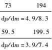
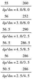
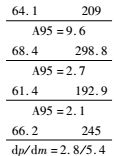
表 1 印度-亚洲碰撞带西段白垩纪-早古近纪古地磁数据表 Table 1 Cretaceous-Early Paleocene Paleomagnetic data of the western segment of the India-Asia collision zone |


|
|
表 2 印度大陆100Ma以来运动轨迹(参考点:36°N, 73°E),据Torsvik等(2012) Table 2 Trajectory of continental India since about 100 Ma (Reference point: 36°N, 73°E), according to Torsvik et al. (2012) |
最新古地磁、地震层析成像资料及数值模拟结果一致地表明印度-科希斯坦-亚洲之间的弧陆及陆陆碰撞发生的位置分别位于赤道及14°N左右(参考点36°N, 73°E).基于以上结果,我们对印度-亚洲碰撞前西构造结附近的新特提斯洋洋陆格局进行了重建(图 4).取85 Ma为时间节点,利用Torsvik等(2012)视极移曲线,我们对欧亚板块、非洲-阿拉伯板块及印度大陆的古地理位置进行了重建;利用上文总结的古地磁数据,我们将科希斯坦-拉达克岛弧和亚洲南缘分别放置于赤道及北纬约14°N附近,参考古地磁数据及残留洋壳的几何特征,重建的岛弧及大陆边缘均具有北西-南东向展布的准线性特征.印度大陆北缘在约85 Ma时大约处于南纬19~23°S之间.然而,由于现有的地球物理资料倾向于认为印度大陆在初始碰撞后已经下插到欧亚板块之下,其碰撞前的大小比现今的尺寸至少大数百公里(Kind et al., 2002; Owens and Zandt, 1997; Zhao et al., 1993; Zhang and Klemperer, 2011),而从岗巴盆地获得的古地磁结果则表明印度大陆的北向延伸量至少在1500km以上(Patzelt et al., 1996), 因此必须考虑一个碰撞前的“大印度”的存在.同时,由于喜马拉雅内部地壳缩短量的差异,“大印度”的大小在东西两侧也很可能是不同的.目前从Zanskar地区只报道了重磁化的结果(Appel et al., 1995; ),尚没有可靠的古地磁数据能够对碰撞前印度大陆的北向延伸量提供直接有效的约束.通过恢复跨越喜马拉雅地区的平衡剖面,得到西构造结附近喜马拉雅的地壳缩短量为约470 km,这可能代表“大印度”北向延伸量的最小值.根据以上要素重建的碰撞前新特提斯洋的洋陆格局如图 4所示.
3 印度/亚洲大陆初始碰撞时间的估算描述板块初始碰撞过程最基本要素除了碰撞位置外,就是板块初始碰撞时间的问题.通过碰撞前后缝合带两侧块体古纬度的对比,能够为印度-亚洲大陆初始碰撞时间提供最直接的约束.比如,通过岗巴盆地与林周盆地晚白垩世至早古近纪古地磁数据的对比,Yi等(2011)得到印度-亚洲大陆在碰撞带东段发生初始碰撞的时间很可能不晚于约60.5 Ma.然而,类似的对比工作在印度-亚洲碰撞带西段却不能有效的进行,这是由于特提斯喜马拉雅西段目前尚缺乏可靠的古地磁数据,无法对碰撞前后印度大陆北缘的古地理位置提供有效约束.在精确厘定(弧陆、陆陆)初始碰撞位置及已知印度大陆运动轨迹的基础上,初始碰撞时间是大印度大小的函数(Yi et al., 2015).在上文中,我们通过古地磁、层析成像资料及数值模拟对碰撞前亚洲大陆南缘、科希斯坦-拉达克岛弧及古海沟的位置进行了有效约束,重建了碰撞前的洋陆格局;在下面的篇幅里,通过设定碰撞前印度大陆的不同尺寸,利用印度大陆最新的视极移曲线,对弧陆及陆陆初始碰撞的时间分别进行讨论,同时结合其他地质、地球物理以及地球化学的资料对不同情境下得到初始碰撞时间的合理性进行评估.
印度大陆140 Ma以来的运动轨迹是目前最精确的板块运动资料之一,这是因为它可以由多方面独立的资料进行重建,如丰富的热点资料提供了热点参考系下印度板块的运动轨迹,而印度洋的洋底资料(磁异常条带)精确地再现了印度洋打开的历史;此外,由于印度大陆与相邻的非洲、阿拉伯、澳大利亚以及南极大陆目前仍然是被动离散的关系,其运动轨迹还可以由相邻板块的运动学资料间接获得.目前,不同版本的印度板块视极移曲线基本吻合(如,Acton, 1999; Besse and Courtillot, 2002; Schettino and Scotese, 2005; Torsvik et al., 2012),本文采用Torsvik等(2012)印度参考系下的全球视极移曲线对印度大陆的运动轨迹进行定位,设定三种不同尺寸“大印度”的情景模式(0,470 km,1500 km分别对应模式Ⅰ、Ⅱ和Ⅲ)对弧陆和陆陆初始碰撞时间进行讨论.
由模式1,即假定碰撞前印度大陆跟现今尺寸一样,由此得到印度-科希斯坦-拉达克岛弧最晚发生弧陆碰撞的年龄为约58 Ma,而印度大陆最终与亚洲大陆南缘发生初始碰撞的时间为约43 Ma;由模式2,即考虑到大印度北缘至少发生了约470 km的地壳缩短(Coward and Butler, 1985),由此得到弧陆碰撞时间为约62 Ma;陆陆碰撞时间为约48 Ma;由模式3,假定碰撞前印度大陆在其西侧的北向延伸量与东部的岗巴地区相当(约1500 km,Yi et al., 2011),由此得到的弧陆碰撞年龄为约69 Ma,而陆陆碰撞的年龄为约55 Ma.由于模式1假定喜马拉雅内部没有任何缩短,这在实际上跟现有地质地球物理资料是完全不符的,本文认为这种情况只存在“理论上的可能性”,这意味着印度大陆与科西斯坦-拉达克岛弧发生初始碰撞不可能晚于约58 Ma,而最终的陆陆初始碰撞不可能晚于约43 Ma;模式2考虑了西构造附近喜马拉雅内部的地壳缩短,因而比模式1设定的情境更为合理,但考虑地壳缩短量是平衡剖面计算的结果,仍然可能低估了实际值,因此我们认为弧陆初始碰撞很可能不晚于约62 Ma,而陆陆初始碰撞不晚于约48 Ma.
4 结论及展望 4.1本文通过对印度-亚洲碰撞带西段古地磁、地震层析成像资料的总结,通过初步的数值模拟,对碰撞带西段碰撞前的洋陆格局进行了重建,对初始碰撞位置和时间进行了初步的探讨,主要得到以下初步结论:
1) 通过对西构造结附近各地体早白垩世至早古近纪古地磁结果(6个原生分量和35个次生分量)进行梳理,得到亚洲大陆南缘及科西斯坦-拉达克岛弧在碰撞前分别处于约14°N(参考点:31.5°N, 80°E)和赤道附近.
2) 全球地震层析成像资料显示新特提斯洋残留洋壳的南缘在西构造结附近分别位于约16°N和赤道附近(Van der Voo et al., 1999b; Replumaz and Tapponnier, 2003; Replumaz et al., 2010, 2013, 图 4),而初步的数值模拟揭示残留洋壳现今的位置很可能代表了初始碰撞开始、洋壳发生断离的位置(图 3),这一结论与基于古地磁数据重建的洋陆格局吻合(图 4).

|
图 3 印度-亚洲碰撞带西段古地磁重磁化分量对应的古纬度分布,误差范围为2个标准差 Figure 3 Paleolatitudes distribution in accordance with the secondary components obtained from the western segment of the India-Asia collision zone, the error interval is shown in 2σ |
3) 通过对陆陆、弧陆初始碰撞位置的厘定,结合印度板块的运动图像及不同的大印度模型,对不同情境下的初始碰撞时间进行了推测(图 5).考虑到西构造结附近喜马拉雅内部的缩短量至少为470 km,我们认为弧陆碰撞和陆陆碰撞的时间分别不晚于约62 Ma和约48 Ma.

|
图 5 印度-亚洲碰撞带西段弧陆-陆陆初始碰撞时间的推断(参考点36°N, 73°E) Figure 5 Evaluation of the initial collision time between India, Ladhak-kohistan and Asia |
本文对印度-亚洲碰撞带西段碰撞前的古地理格局进行了重建,进而为一系列重要科学问题的讨论奠定了坚实的基础,例如亚洲大陆内部碰撞后的地壳缩短量和变形模式以及印度-亚洲大陆在西构造结附近发生初始碰撞的时间等.然而,正如我们所看到的一样,印度-科西斯坦-亚洲初始碰撞时间的问题仍然极大地受限于西构造结附近印度大陆北缘,即特提斯喜马拉雅古地磁数据的缺乏,进一步加强西构造结附近特提斯喜马拉雅的古地磁研究有助于最终解决上述问题.
致谢 感谢评审专家对本文提出重要的意见, 感谢梁雅伦对本文的校对和整理.| [] | Ahmad M N, Fujiwara Y, Paudel L P. 2001. Remagnetization of igneous rocks in Gupis area of Kohistan arc, northern Pakistan[J]. Earth, Planets and Space, 53(5): 373–384. DOI:10.1186/BF03352394 |
| [] | Ahmad M N, Yoshida M, Fujiwara Y. 2000. Paleomagnetic study of Utror Volcanic Formation:Remagnetizations and postfolding rotations in Utror area, Kohistan arc, northern Pakistan[J]. Earth, Planets and Space, 52(6): 425–436. DOI:10.1186/BF03352254 |
| [] | Appel E, Müller R, Widder R W. 1991. Palaeomagnetic results from the Tibetan sedimentary series of the Manang area (North central nepal)[J]. Geophysical Journal International, 104(2): 255–266. DOI:10.1111/gji.1991.104.issue-2 |
| [] | Appel E, Patzelt A, Chouker C. 1995. Secondary palaeoremanence of Tethyan sediments from the Zanskar Range (NW Himalaya)[J]. Geophysical Journal International, 122(1): 227–242. DOI:10.1111/gji.1995.122.issue-1 |
| [] | Argand E. 1924. La tectonique de I'Asie[C].//Proc. 13th Int. Geol. Cong., Vol. 1, Part 5. Liège:Vaillant-Carmanne, 171-372. |
| [] | Burg J P. 2011. The Asia-Kohistan-India collision:Review and discussion[A].//Brown D, Ryan P D eds. Arc-Continent Collision[M]. Berlin Heidelberg:Springer, 279-309. |
| [] | Chen J S, Huang B C, Sun L S. 2010. New constraints to the onset of the India-Asia collision:Paleomagnetic reconnaissance on the Linzizong Group in the Lhasa Block, China[J]. Tectonophysics, 489(1-4): 189–209. DOI:10.1016/j.tecto.2010.04.024 |
| [] | Chen J S, Huang B C, Yi Z Y, et al. 2014. Paleomagnetic and 40Ar/39Ar geochronological results from the Linzizong Group, Linzhou Basin, Lhasa Terrane, Tibet:Implications to Paleogene paleolatitude and onset of the India-Asia collision[J]. Journal of Asian Earth Sciences, 96: 162–177. DOI:10.1016/j.jseaes.2014.09.007 |
| [] | Chen Y, Cogné J P, Courtillot V, et al. 1993b. Cretaceous Paleomagnetic Results from Western Tibet and Tectonic Implications[J]. Journal of Geophysical Research, 98(B10): 17981–17999. DOI:10.1029/93JB01006 |
| [] | Chen Y, Courtillot V, Cogné J P, et al. 1993a. The configuration of Asia prior to the collision of India:Cretaceous paleomagnetic constraints[J]. Journal of Geophysical Research, 98(B12): 21927–21941. DOI:10.1029/93JB02075 |
| [] | Clift P D, Hannigan R, Blusztajn J, et al. 2002. Geochemical evolution of the Dras-Kohistan Arc during collision with Eurasia:Evidence from the Ladakh Himalaya, India[J]. Island Arc, 11(4): 255–273. DOI:10.1046/j.1440-1738.2002.00371.x |
| [] | Corfield R I, Searle M P, Green O R. 1999. Photang thrust sheet:An accretionary complex structurally below the Spontang ophiolite constraining timing and tectonic environment of ophiolite obduction, Ladakh Himalaya, NW India[J]. Journal of the Geological Society, 156(5): 1031–1044. DOI:10.1144/gsjgs.156.5.1031 |
| [] | Corfield R I, Searle M P, Pedersen R B. 2001. Tectonic setting, origin, and obduction history of the Spontang Ophiolite, Ladakh Himalaya, NW India[J]. The Journal of Geology, 109(6): 715–736. DOI:10.1086/323191 |
| [] | Coward M P, Butler R W H. 1985. Thrust tectonics and the deep structure of the Pakistan Himalaya[J]. Geology, 13(6): 417–420. DOI:10.1130/0091-7613(1985)13<417:TTATDS>2.0.CO;2 |
| [] | Coward M P, Butler R W H, Khan M A, et al. 1987. The tectonic history of Kohistan and its implications for Himalayan structure[J]. Journal of the Geological Society, 144(3): 377–391. DOI:10.1144/gsjgs.144.3.0377 |
| [] | Dupont-Nivet G, Lippert P C, Van Hinsbergen D J J, et al. 2010. Palaeolatitude and age of the Indo-Asia collision:Palaeomagnetic constraints[J]. Geophysical Journal International, 182(3): 1189–1198. DOI:10.1111/j.1365-246X.2010.04697.x |
| [] | Gansser A. 1964. The Geology of the Himalayas[M]. New York, NY: Wiley. |
| [] | Gansser A. 1980. The significance of the Himalayan suture zone[J]. Tectonophysics, 62(1-2): 37–52. DOI:10.1016/0040-1951(80)90134-1 |
| [] | Grand S P, van der Hilst R D, Widiyantoro S. 1997. Global seismic tomography:A snapshot of convection in the Earth[J]. GSA Today, 7(4): 1–7. |
| [] | Heim A, Gansser A. 1939. Central Himalaya:Geological Observations of the Swiss Expedition 1936[R]. Band:Denkschriften der Schweizerischen Naturforschenden Gesellschaft, 1-246. |
| [] | Jackson M, Swanson-Hysell N L. 2012. Rock magnetism of remagnetized carbonate rocks:Another look[J]. Geological Society, London, Special Publications, 371(1): 229–251. DOI:10.1144/SP371.3 |
| [] | Kaneko Y, Katayama I, Yamamoto H, et al. 2003. Timing of Himalayan ultrahigh-pressure metamorphism:Sinking rate and subduction angle of the Indian continental crust beneath Asia[J]. Journal of Metamorphic Geology, 21(6): 589–599. DOI:10.1046/j.1525-1314.2003.00466.x |
| [] | Khan M A, Jan M Q, Weaver B L. 1993. Evolution of the lower arc crust in Kohistan, N. Pakistan:Temporal arc magmatism through early, mature and intra-arc rift stages[J]. Geological Society, London, Special Publications, 74(1): 123–138. DOI:10.1144/GSL.SP.1993.074.01.10 |
| [] | Khan S D, Walker D J, Hall S A, et al. 2009. Did the Kohistan-Ladakh island arc collide first with India?[J]. Geological Society of America Bulletin, 121(3-4): 366–384. DOI:10.1130/B26348.1 |
| [] | Kind R, Yuan X, Saul J, et al. 2002. Seismic images of crust and upper mantle beneath Tibet:Evidence for Eurasian plate subduction[J]. Science, 298(5596): 1219–1221. DOI:10.1126/science.1078115 |
| [] | King R F. 1955. The remanent magnetism of artificially deposited sediments[J]. Geophysical Journal International, 7(3): 115–134. |
| [] | Klootwijk C T. 1984. A review of Indian Phanerozoic palaeomagnetism:Implications for the India-Asia collision[J]. Tectonophysics, 105(1-4): 331–353. DOI:10.1016/0040-1951(84)90212-9 |
| [] | Klootwijk C T, Conaghan P J. 1979. The extent of Greater India, I. Preliminary palaeomagnetic data from the Upper Devonian of the eastern Hindukush, Chitral (Pakistan)[J]. Earth and Planetary Science Letters, 42(2): 167–182. DOI:10.1016/0012-821X(79)90022-0 |
| [] | Klootwijk C T, Conaghan P J, Nazirullah R, et al. 1994. Further palaeomagnetic data from Chitral (Eastern Hindukush):Evidence for an early India-Asia contact[J]. Tectonophysics, 237(1-2): 1–25. DOI:10.1016/0040-1951(94)90156-2 |
| [] | Le Fort P. 1975. Himalayas:the collided range. Present knowledge of the continental arc[J]. American Journal of Science, 275-A: 1–44. |
| [] | Leech M L, Singh S, Jain A K, et al. 2005. The onset of India-Asia continental collision:early, steep subduction required by the timing of UHP metamorphism in the western Himalaya[J]. Earth and Planetary Science Letters, 234(1): pp.83–97. |
| [] | Li Z H. 2014. A review on the numerical geodynamic modeling of continental subduction, collision and exhumation[J]. Science China Earth Sciences, 57(1): 47–69. DOI:10.1007/s11430-013-4696-0 |
| [] | Li Z H, Xu Z Q, Gerya T V. 2011. Flat versus steep subduction:Contrasting modes for the formation and exhumation of high-to ultrahigh-pressure rocks in continental collision zones[J]. Earth and Planetary Science Letters, 301(1-2): 65–77. DOI:10.1016/j.epsl.2010.10.014 |
| [] | Li Z Y, Ding L, Song P P, et al. 2017. Paleomagnetic constraints on the paleolatitude of the Lhasa block during the Early Cretaceous:Implications for the onset of India-Asia collision and latitudinal shortening estimates across Tibet and stable Asia[J]. Gondwana Research, 41: 352–372. DOI:10.1016/j.gr.2015.05.013 |
| [] | Liebke U, Appel E, Ding L, et al. 2010. Position of the Lhasa terrane prior to India0-Asia collision derived from palaeomagnetic inclinations of 53 Ma old dykes of the Linzhou Basin:Constraints on the age of collision and post-collisional shortening within the Tibetan Plateau[J]. Geophysical Journal International, 182(3): 1199–1215. DOI:10.1111/j.1365-246X.2010.04698.x |
| [] | Ma Y M, Yang T S, Yang Z Y, et al. 2014. Paleomagnetism and U-Pb zircon geochronology of Lower Cretaceous lava flows from the western Lhasa terrane:New constraints on the India-Asia collision process and intracontinental deformation within Asia[J]. Journal of Geophysical Research, 119(10): 7404–7424. |
| [] | McCabe C, Van der Voo R, Peacor D R, et al. 1983. Diagenetic magnetite carries ancient yet secondary remanence in some Paleozoic sedimentary carbonates[J]. Geology, 11(4): 221–223. DOI:10.1130/0091-7613(1983)11<221:DMCAYS>2.0.CO;2 |
| [] | Owens T J, Zandt G. 1997. Implications of crustal property variations for models of Tibetan plateau evolution[J]. Nature, 387(6628): 37–43. DOI:10.1038/387037a0 |
| [] | Parrish R R, Gough S J, Searle M P, et al. 2006. Plate velocity exhumation of ultrahigh-pressure eclogites in the Pakistan Himalaya[J]. Geology, 34(11): 989–992. DOI:10.1130/G22796A.1 |
| [] | Patzelt A, Li H M, Wang J D, et al. 1996. Palaeomagnetism of Cretaceous to Tertiary sediments from southern Tibet:Evidence for the extent of the northern margin of India prior to the collision with Eurasia[J]. Tectonophysics, 259(4): 259–284. DOI:10.1016/0040-1951(95)00181-6 |
| [] | Petterson M G, Windley B F. 1985. Rb-Sr dating of the Kohistan arc-batholith in the Trans-Himalaya of north Pakistan, and tectonic implications[J]. Earth and Planetary Science Letters, 74(1): 45–57. DOI:10.1016/0012-821X(85)90165-7 |
| [] | Petterson M G, Windley B F, Luff I W. 1991. The Chalt Volcanics, Kohistan, N. Pakistan; high-Mg tholeiitic and low-Mg calc-alkaline volcanism in a Cretaceous island arc[A].//Sharrna K K. Geology of the Himalayan Collision Zone[M]. Physics and Chemistry of the Earth, 17:19-30. |
| [] | Rehman H U, Seno T, Yamamoto H, et al. 2011. Timing of collision of the Kohistan-Ladakh Arc with India and Asia:Debate[J]. Island Arc, 20(3): 308–328. DOI:10.1111/j.1440-1738.2011.00774.x |
| [] | Replumaz A, Guillot S, Villase?or A, et al. 2013. Amount of Asian lithospheric mantle subducted during the India/Asia collision[J]. Gondwana Research, 24(3-4): 936–945. DOI:10.1016/j.gr.2012.07.019 |
| [] | Replumaz A, Negredo A M, Villase?or A, et al. 2010. Indian continental subduction and slab break-off during Tertiary collision[J]. Terra Nova, 22(4): 290–296. |
| [] | Replumaz A, Tapponnier P. 2003. Reconstruction of the deformed collision zone between India and Asia by backward motion of lithospheric blocks[J]. Journal of Geophysical Research, 108(B6). DOI:10.1029/2001JB000661 |
| [] | Reuber I. 1989. The Dras arc:Two successive volcanic events on eroded oceanic crust[J]. Tectonophysics, 161(1-2): 93–106. DOI:10.1016/0040-1951(89)90305-3 |
| [] | Robinson A C, Yin A, Manning C E, et al. 2004. Tectonic evolution of the northeastern Pamir:Constraints from the northern portion of the Cenozoic Kongur Shan extensional system, western China[J]. GSA Bulletin, 116(7): 953–974. DOI:10.1130/B25375.1 |
| [] | Rowley D B. 1996. Age of initiation of collision between India and Asia:A review of stratigraphic data[J]. Earth and Planetary Science Letters, 145(1-4): 1–13. DOI:10.1016/S0012-821X(96)00201-4 |
| [] | Schaltegger U, Frank M, Burg J P. 2003. A 120 million years record of magmatism and crustal melting in the Kohistan Batholith[C].//EGS-AGU-EUG Joint Assembly. Geophysical Research Abstracts. European Geophysical Society, 06816. |
| [] | Searle M P, Windley B F, Coward M P, et al. 1987. The closing of Tethys and the tectonics of the Himalaya[J]. Geological Society of America Bulletin, 98(6): 678–701. DOI:10.1130/0016-7606(1987)98<678:TCOTAT>2.0.CO;2 |
| [] | Sun Z M, Jiang W, Li H B, et al. 2010. New paleomagnetic results of Paleocene volcanic rocks from the Lhasa block:Tectonic implications for the collision of India and Asia[J]. Tectonophysics, 490(3-4): 257–266. DOI:10.1016/j.tecto.2010.05.011 |
| [] | Sun Z M, Pei J L, Li H B, et al. 2012. Palaeomagnetism of late Cretaceous sediments from southern Tibet:Evidence for the consistent palaeolatitudes of the southern margin Eurasia prior to the collision with India[J]. Gondwana Research, 21(1): 53–63. DOI:10.1016/j.gr.2011.08.003 |
| [] | Tahirkheli R A K. 1979. Geology of Kohistan and adjoining Eurasian and Indo-Pakistan continents, Pakistan[J]. Geol. Bull. Univ. Peshawar, 11(1): 1–30. |
| [] | Tapponnier P, Peltzer G, Le Dain A Y, et al. 1982. Propagating extrusion tectonics in Asia:New insights from simple experiments with plasticine[J]. Geology, 10(12): 611–616. DOI:10.1130/0091-7613(1982)10<611:PETIAN>2.0.CO;2 |
| [] | Torsvik T H, Van der Voo R, Preeden U, et al. 2012. Phanerozoic polar wander, palaeogeography and dynamics[J]. Earth-Science Reviews, 114(3-4): 325–368. DOI:10.1016/j.earscirev.2012.06.007 |
| [] | Treloar P J, Rex D C, Guise P G, et al. 1989. K-Ar and Ar-Ar geochronology of the Himalayan collision in NW Pakistan:Constraints on the timing of suturing, deformation, metamorphism and uplift[J]. Tectonics, 8(4): 881–909. DOI:10.1029/TC008i004p00881 |
| [] | van der Hilst R, Engdahl R, Spakman W, et al. 1991. Tomographic imaging of subducted lithosphere below northwest Pacific island arcs[J]. Nature, 353(6339): 37–43. DOI:10.1038/353037a0 |
| [] | Van der Hilst R D, Widiyantoro S, Engdahl E R. 1997. Evidence for deep mantle circulation from global tomography[J]. Nature, 386(6625): 578–584. DOI:10.1038/386578a0 |
| [] | Van der Voo R, Spakman W, Bijwaard H. 1999a. Mesozoic subducted slabs under Siberia[J]. Nature, 397(6716): 246–249. DOI:10.1038/16686 |
| [] | Van der Voo R, Spakman W, Bijwaard H. 1999b. Tethyan subducted slabs under India[J]. Earth and Planetary Science Letters, 171(1): 7–20. DOI:10.1016/S0012-821X(99)00131-4 |
| [] | van Hinsbergen D J J, Kapp P, Dupont-Nivet G, et al. 2011. Restoration of Cenozoic deformation in Asia and the size of Greater India[J]. Tectonics, 30(5). DOI:10.1029/2011TC002908 |
| [] | Yang T S, Ma Y M, Bian W W, et al. 2015b. Paleomagnetic results from the Early Cretaceous Lakang Formation lavas:Constraints on the Paleolatitude of the Tethyan Himalaya and the India-Asia collision[J]. Earth and Planetary Science Letters, 428: 120–133. DOI:10.1016/j.epsl.2015.07.040 |
| [] | Yang T S, Ma Y M, Zhang S H, et al. 2015a. New insights into the India-Asia collision process from Cretaceous paleomagnetic and geochronologic results in the Lhasa terrane[J]. Gondwana Research, 28(2): 625–641. DOI:10.1016/j.gr.2014.06.010 |
| [] | Yi Z Y, Huang B C, Yang L K, et al. 2015. A quasi-linear structure of the southern margin of Eurasia prior to the India-Asia collision:First paleomagnetic constraints from upper Cretaceous volcanic rocks near the western syntaxis of Tibet[J]. Tectonics, 34(7): 1431–1451. DOI:10.1002/tect.v34.7 |
| [] | Yin A, Harrison T M. 2000. Geologic evolution of the Himalayan-Tibetan orogen[J]. Annual Review of Earth and Planetary Sciences, 28(1): 211–280. DOI:10.1146/annurev.earth.28.1.211 |
| [] | Yoshida M, Zaman H, Ahmad M N. 1996. Paleopositions of Kohistan Arc and surrounding terranes since Cretaceous time:The paleomagnetic constraints[C].//Proceedings of Geoscience Colloquium, Geoscience Laboratory Project. Islamabad, Pakistan:Geological Survey of Pakistan, 15:83-101. |
| [] | Zhang Z J, Klemperer S. 2010. Crustal structure of the Tethyan Himalaya, southern Tibet:new constraints from old wide-angle seismic data[J]. Geophysical Journal International, 181(3): 1247–1260. |
| [] | Zhao W J, Nelson K D, Che J, et al. 1993. Deep seismic reflection evidence for continental underthrusting beneath Southern Tibet[J]. Nature, 366(6455): 557–559. DOI:10.1038/366557a0 |
| [] | Ziabrev S V, Aitchison J C, Abrajevitch A V, et al. 2004. Bainang Terrane, Yarlung-Tsangpo suture, southern Tibet (Xizang, China):A record of intra-Neotethyan subduction-accretion processes preserved on the roof of the world[J]. Journal of the Geological Society, 161(3): 523–539. DOI:10.1144/0016-764903-099 |
| [] | 李忠海. 2014. 大陆俯冲-碰撞-折返的动力学数值模拟研究综述[J]. 中国科学:地球科学, 44(5): 817–841. |