2. 地球空间环境与大地测量教育部重点实验室, 武汉 430079;
3. 自然资源部地球物理大地测量重点实验室, 武汉 430079
2. Key Laboratory of Geospace Environment and Geodesy, Ministry of Education, Wuhan 430079, China;
3. Key Laboratory of Geophysical Geodesy, Ministry of Natural Resources, Wuhan 430079, China
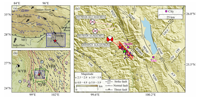
川滇菱形块体位于青藏高原东缘,受印度板块和欧亚板块持续碰撞及刚性四川盆地阻挡的影响,其地壳运动以顺时针旋转为主(图 1a和1b).该地区发育着许多构造活动强烈的大型走滑断层,如: 鲜水河、安宁河、则木河、小江、金沙江和红河断裂带等,这些断裂带共同围限出川滇菱形块体(徐锡伟等,2003;图 1b).相较于川滇块体东边界(主要包括:鲜水河、安宁河、则木河和小江断裂)较高的滑动速率及地震活动(李姜一等,2020; Fu et al., 2020;Cheng et al., 2021),块体西边界(主要包括:金沙江和红河断裂带)的滑动速率及地震活动相对较低(常祖峰等,2016; Shi et al., 2018).除红河断裂带关注度较高外,西边界其他断裂研究程度相对较低.作为北部金沙江断裂和南部红河断裂带的连接部分,维西—乔后—巍山断裂在区域构造形变上具有重要的控制作用(常祖峰等,2016).2021年5月21日(北京时间21 ∶ 48 ∶ 37),在中国云南省大理州发生了MS6.4浅源地震(震中深度8 km) (https://news.ceic.ac.cn).这次地震的震中位于维西—乔后—巍山断裂的巍山盆地段西侧约7 km处,距离漾濞县约9 km(图 1c).震中区域发育着许多西北-东南走向的构造断层,且总体以走滑运动为主要特点.该事件是自1976年以来发生在维西—乔后—巍山断裂巍山盆地段附近最大的一次地震,为研究区域构造活动提供了一个稀有的机会(图 1c).在地震发生前27分钟,一个MS5.6前震出现在主震震中东南方向约5 km处;震后一周内共发生了39个MS2.9以上的余震(图 1c).余震集中分布在主震的东南方向处,且呈西北-东南向线性排列.这些余震的整体分布暗示着主震沿东南走向的发震断层由西北向东南单向破裂.根据新闻报道(https://www.360kuai.com/pc/9c536224badb87971?cota=3&kuai_so=1&refer_scene=so_3&sign=360_da20e874&tj_url=so_vip),该次地震造成了3人死亡,28人受伤,192间房屋倒塌,13090间房屋损坏,道路、桥梁、水利及电力通信基础设施受损.根据美国地质调查局(U.S.Geological Survey, USGS, https://www.usgs.gov/)、美国哈佛大学(Global Centroid-Moment-Tensor, GCMT, https://www.globalcmt.org/)和德国地球科学研究中心(German Research center for geoscience, GFZ, http://geofon.gfz-potsdam.de/) 公布的震源机制解(表 1),这次地震破裂在一个东南走向或西北走向的高倾角右旋走滑断层上.

|
图 1 (a) 青藏高原及相邻区域的构造背景;(b)川滇地区的构造背景;(c)2021年漾濞地震区域构造背景 (a)中黑粗箭头为块体的运动方向(Xu et al., 2013).AKMS:阿尼玛卿—昆仑—麻扎塔格缝合带;JS:金沙江缝合带;BNS:班公怒江缝合带;IYS:雅鲁藏布江缝合带;MFT:喜马拉雅主前缘逆冲带.(b)中,SYRB:川滇菱形块体;WYB:西部云南块体;BPB:保山—普洱块体;SYB:南部云南块体.暗红色曲线为各个块体的边界, 修改自Tian等(2019);绿色方框为InSAR数据覆盖范围;GPS数据来自Zheng等(2017).(c)中黑细线为断层迹线.YPF:永平断裂;WQYF:维西—乔后—巍山断裂的玉狮场—乔后段;WQWF:维西—乔后—巍山断裂的巍山盆地段;WQSF:维西—乔后—巍山断裂南段;NEMF:洱源—弥渡断裂北段;MEMF:洱源—弥渡断裂中段;SEMF:洱源—弥渡断裂南段;YPCF:鱼棚村断裂;CPF:曾家营—永福哨断裂;JXF:九顶山—孝秀庄断裂;JCF:苴力—春元断裂.紫色圆和黄色圆分别表示来自于中国地震台网中心(China Earthquake Networks Center, CENC,https://news.ceic.ac.cn)震后一周的余震序列和2012年至2021年的历史地震;白色圆为来自于美国地质调查局(USGS)的1976年至2012年的历史地震.红色和绿色五角星分别为来自于中国地震台网中心主震和前震的震中.红色矩形代表2021年漾濞地震破裂断层面在地表的投影;粗红线为地表迹线.Dali:大理州;Yangbi:漾濞县.图中断层的位置及名字参考中国地震局地质研究所(https://www.eq-igl.ac.cn/). 红色沙滩球为2021年漾濞地震的震源机制解;图 1b和1c中的黑、浅蓝和粉色沙滩球分别为来自于GCMT(https://www.globalcmt.org/)的历史逆冲、正断和走滑型地震的震源机制解. Fig. 1 (a) Tectonic setting of the Tibetan Plateau and its adjacent areas, (b) Tectonic setting of the Sichuan-Yunnan region, (c) Regional tectonic setting of the 2021 Yangbi earthquake In (a), thick black arrows indicates the block motion direction (Xu et al., 2013). AKMS: Anyimaqen-Kunlun-Muztagh suture zone; JS: Jinsha suture zone; BNS: Bangong Nujiang suture zone; IYS: Yarlung Zangbo suture zone; MFT: Himalayan Main frontal thrust. In (b), SYRB: Sichuan-Yunnan rhomboid block; WYB: Western Yunnan block; BPB: Baoshan-Puer block; SYB: Southern Yunnan block. Dark red curves represent the boundaries of the plates, which are modified from Tian et al. (2019). Green boxes show the coverage of InSAR data; GPS data come from Zheng et al. (2017). In (c), thin black lines are fault traces. YPF: Yongping fault; WQYF: Yushichang-Qiaohou segment of the Weixi-Qiaohou-Weishan fault; WQWF: Weishan segment of the Weixi-Qiaohou-Weishan fault; WQSF: Southern segment of the Weixi-Qiaohou-Weishan fault; NEMF: Northern segment of the Eryuan-Midu fault; MEMF: Middle segment of the Eryuan-Midu fault; SEMF: Southern segment of the Eryuan-Midu fault; YPCF: Yupengcun fault; CPF: Cengjiaying-Yongfushao fault; JXF: Jiudingshan-Xiaoxiuzhuang fault; JCF: Juli-Chunyuan fault. Purple and yellow circles show the aftershocks one week after the mainshock and historical earthquakes that occurred between 2012 and 2021, respectively, from the China Earthquake Networks Center (CENC, https://news.ceic.ac.cn), while white circles indicate the historical earthquakes that occurred between 1976 and 2012, from the USGS. Red and green stars represent the epicenters of the mainshock and foreshock, respectively, from the CENC. Red box represents the surface projection of the rupture fault plane of the 2021 Yangbi earthquake while thick red line shows the fault trace. Dali: Dali Prefecture; Yangbi: Yangbi County. The locations and names of faults refer to the Institute of Geology, China Earthquake Administration (https://www.eq-igl.ac.cn/). Red beach ball shows the focal mechanism solution of the 2021 Yangbi earthquake; Black, lightblue and pink beach balls in figures 1b and 1c represent focal mechanism solutions of the historical thrust, normal and strike-slip earthquakes, respectively, from GCMT. |
|
|
表 1 2021年漾濞地震震源参数 Table 1 Source parameters of the 2021 Yangbi earthquake |
归功于密集的卫星观测,本研究首先利用哨兵-1A/B卫星的升、降轨数据获取了与2021年MS6.4云南漾濞地震相关的高精度高分辨率的同震形变;然后基于弹性位错理论,利用同震InSAR观测数据反演了此次事件的破裂断层几何参数及详细的同震滑动分布;最后,讨论了此次地震的同震滑动亏损成因、发震断层及附近断层的潜在危险性.
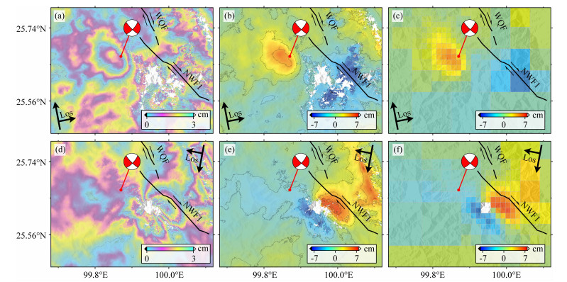
1 InSAR数据处理作为过去45年在维西—乔后—巍山断裂巍山盆地段附近发生的最大一次地震,提取与漾濞地震相关的形变信息对理解川滇块体西边界区域活跃断层的构造特性及地震灾害具有重要的意义.基于Gamma软件(Werner et al., 2000),我们采用双轨法提取了覆盖此次地震区域的升轨和降轨的同震干涉图(表 2).为了在一定程度上抑制噪声,我们将哨兵1的距离向与方位向的多视比设置为10 ∶ 2,并利用30 m的数字高程模型移除了地形相位的贡献.为获得较高的信噪比,我们利用功率频谱滤波方法对干涉图进行滤波(Goldstein and Werner, 1998).然后基于枝切法对干涉图进行解缠(Goldstein et al., 1988);最后对干涉图进行地理编码,将其纳入WGS84坐标系框架中.此外,我们还利用远场非形变区域的观测数据估计得到一个关于位置、高程和误差相位的线性函数,从而去除轨道残差和地形相关的大气延迟(Cavalié et al., 2007). 由于震中附近区域较稀疏的植被覆盖,我们得到了高质量的与2021年漾濞地震相关的同震形变场(图 2).升轨同震干涉图(图 2a和2b)在震中区域展现出了一个朝向卫星运动的叶状型形变条纹,其视线向形变量约为5.2 cm,而降轨同震干涉图(图 2d和2e)在震中南部显示出两个主要的叶状型形变条纹(其中,西南部形变条纹远离卫星运动,而东南部形变条纹朝向卫星运动),其视线向形变量分别约为-6.9 cm和7.7 cm.这三个主要的叶状型形变条纹分别位于震中区域的北、西南和东南处,这种现象暗示着此次漾濞地震为一个走滑型事件.鉴于升轨和降轨同震视线向形变分别仅覆盖震后5天和1天的数据以及该次事件较小的震级,我们认为提取的同震形变场中仅包含有较小的震后形变.
|
|
表 2 用于生成同震形变的SAR数据信息 Table 2 Details of SAR data used for coseismic deformation |

|
图 2 (a) 和(d)分别为2021年漾濞地震升轨99和降轨135的同震干涉条纹图;(b)和(e)为对应的同震视线向位移;黑色曲线代表以2 cm为间隔的同震形变等值线;(c)和(f)为对应的降采样数据 Fig. 2 (a) and (d) are the ascending track 99 and descending track 135 coseismic interferograms, respectively, (b) and (e) are the corresponding coseismic line-of-sight displacement; the black curved lines represent the contours of each 2 cm coseismic deformation, (c) and (f) are the corresponding downsampled data |
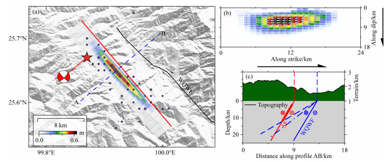
本文利用基于分辨率的降采样方法(Lohman and Simons, 2005)对2021年云南漾濞地震的同震形变场进行重采样(图 2c和2f),然后基于弹性半空间均匀介质的矩形位错理论(Okada, 1985)对断层滑动进行反演.首先,采用非线性反演方法对断层几何参数进行反演,其次以线性反演算法来获得断层面上详细的滑动分布.多峰值粒子群方法被用来搜索最优的断层位置、走向、倾角、滑动角、断层宽度、长度、断层上边界埋深及滑动量(Feng et al., 2013). 综合考虑余震序列的整体分布(图 1c)、同震形变干涉图的特点(图 2a和2d)及USGS机构公布的震源机制解(表 1),我们认为此次地震为一个倾向西南的右旋走滑型地震,从而在反演中约束断层的走向和滑动角区间分别为(91°, 179°)和(-179°, -135°). 在初始反演中,仅对走向角和滑动角进行约束,而断层其他参数自由收敛,反演结果显示在极狭窄的断层宽度(小于0.1 km)上滑动量达到极高的值(30 m),这种现象与实际的破裂断层明显不符.然后,在反演中固定断层宽度,从0.5 km开始,以0.5 km为间隔进行多次反演,结果显示:在断层其他参数较为稳定的情况下,断层滑动随着断层宽度的增加而逐渐减小(图 3b).最后,根据经典的断层宽度与震级的经验公式(Wells and Coppersmith, 1994),固定断层宽度为8.7 km进行非线性反演.最优的反演结果(表 1)显示此次漾濞地震破裂在一个长度约12 km、东南走向(走向角约为139°)的具有少量正断分量的右旋走滑断层(滑动角约为-170°)上.反演得到破裂断层上边界埋深2 km的深度意味着这次地震为一个隐伏型事件.此外,为了评估震源参数的可靠性,我们用蒙特卡罗方法(Parsons et al., 2006)对原始观测添加噪声扰动,生成100组观测数据进行反演,结果显示所有的断层几何参数均较为稳定(图 3a).

|
图 3 (a) 蒙特卡罗分析的均匀断层面几何参数;(b)非线性反演中断层宽度与滑动量的关系;(c)不同倾角和平滑因子的log(ξ+ψ)函数的等值线图 (a)中,直方图代表100组噪声扰动数据反演得到的断层几何参数的分布,黄色圆圈代表每次反演待求参数的分布情况.实红线代表最优断层几何参数,虚红线为待求参数的正态分布.(c)中,红色五角星代表全局最小;最优倾角和平滑因子分别为80°和1.7. Fig. 3 (a) Geometric parameters for the uniform fault plane from the Monte-Carlo analysis. (b) The relationship between fault width and slip during the nonlinear inversion. (c) Contour map of log(ξ+ψ) with different dip angles and smoothing factors In (a), histograms show the distribution of fault geometry parameters obtained from inversions of 100 data sets perturbed with random noise. Yellow circles show the distribution of the parameters to be solved in each inversion. Solid and dashed red lines represent the optimal fault geometric parameters and the normal distribution of the parameters to be solved, respectively. In (c), red star depicts the global minimum. The optimal dip and smoothing factor are 80° and 1.7, respectively. |
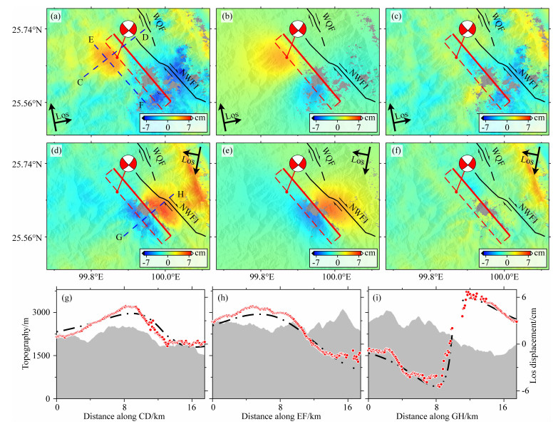
首先固定均匀滑动模型中得到的最优发震断层的位置、倾角和走向角,并分别沿走向和倾向扩大断层面的长度和宽度为24 km和18 km,然后将断层面离散成432个1 km宽、1 km长的小矩形.同时,为避免断层面上滑动出现剧烈的震荡,在反演中添加了平滑因子.考虑到均匀滑动分布模型中得到的倾角对于精细滑动分布并不是最优的(Bürgmann et al., 2002),在随后的线性反演中进一步优化倾角.为搜索到最优的倾角及平滑因子,采用一个log函数:f(δ, α2)=log(Ψ+ξ),来对倾角和平滑因子进行估计(Feng et al., 2013;图 3c).其中,ξ和Ψ分别代表残差和滑动粗糙度,而α2和δ分别代表平滑因子和倾角.此外,还进一步约束滑动在断层面的左、右及下边界为0,随后进行线性反演.结果(图 4b)显示破裂断层以右旋走滑为主,同时伴随着少量的正断分量;滑动主要分布在深度2到12 km范围内,在7 km深度处滑动达到最大,约为0.64 m;凹凸体上倾区域0~2 km范围内较小的滑动量暗示同震滑动并未破裂到地表.滑动分布模型产生了~1.48×10¹⁸N·m的矩阵量,相当于MW6.1.正演结果(图 5)显示该模型较好的拟合了升轨99和降轨135的同震观测形变,残差分别为0.81 cm和0.65 cm,而升轨干涉图中破裂断层面东南处相对较大的残差可能与该区域残余的大气噪声有关.

|
图 4 (a) 2021年漾濞地震投影到地表的同震滑动分布模型;(b)沿走向和倾向投影的同震滑动分布模型;(c)沿图(a)中剖线AB的地形及断层结构 (b)中,白色箭头表示断层上盘相对于断层下盘的运动方向.(c)中,SF:发震断层;WQWF:维西—乔后—巍山断裂巍山盆地段.蓝色虚线、点虚线和实线分别为倾角63°、69°和80°的维西—乔后—巍山断裂巍山盆地段的地下结构. 细红线为反演得到的发震断层剖面,叠加在细红线上的粗红线代表主要的滑动区域. Fig. 4 (a) Surface projection of coseismic distributed slip model of the 2021 Yangbi earthquake. (b) The projection of coseismic distributed slip model along strike and dip directions. (c) Topography and fault structure along the profile AB in figure (a) In (b), white arrows depict the motion direction of the hanging wall relative to the footwall wall. In (c), SF: seismogenic fault; WQWF: Weishan segment of the Weixi-Qiaohou-Weishan fault. Blue dashed, dot-dashed and solid lines indicate the inferred fault subsurface structures with a dip of 63°, 69° and 80°, respectively. Thin red line shows the section of the inverted seismogenic fault. Thick red line superimposed on the thin red line indicates the main slip area. |

|
图 5 (a) 和(d)分别为升轨99和降轨135的同震观测形变;(b)和(e)为对应的模拟数据;(c)和(f)为残差;(g)、(h)和(i)分别为沿剖线CD、EF和GH的同震形变 (a—f)中,粗红线为地表迹线,虚红线为埋深在地下的破裂面框架.(g—i)中,黑色点虚线为观测数据,红色圆代表模拟数据. Fig. 5 (a) and (d) are the observed coseismic displacements for the ascending track 99 and descending track 135, respectively. (b) and (e) are the corresponding modeled data. (c) and (f) are the residuals. (g), (h) and (i) are coseismic displacements along the profile CD, EF and GH, respectively In (a—f), thick red line depicts the fault surface trace while dashed red line shows the surface projection of the rupture fault plane. In (g—i), black dot-dashed line represents the observed data while red circles show the modeled data. |
浅层同震滑动亏损现象在中强走滑地震中普遍存在,比如:1992年Landers、1999年Hector Mine和2010年EI Mayor-Cucapah地震(如Xu et al., 2016).图 4a和4b显示2021年漾濞地震的同震滑动并没有达到地表,且主要集中分布在2至12 km深度范围内,而0至2 km深度范围内破裂断层滑动的缺失可以用浅层滑动亏损的机制来解释.对于造成走滑型地震中浅层滑动亏损的原因通常可以归为三类:(1)浅层脆性地壳的速度强化特性阻碍了破裂断层深源同震滑动向上的传播(Marone et al., 1991);(2)破裂断层地表附近的非弹性形变减少了同震应力的积累,从而导致了同震滑动亏损的存在(Kaneko and Fialko, 2011);(3)大地测量数据在破裂断层地表附近覆盖的不完整性或缺失导致了反演过程中对断层浅源滑动分布的低估(Xu et al., 2016). 本文反演中使用的升、降轨同震观测数据(图 5a和5d)在破裂断层中段区域显示出了断层近场数据的缺失,而这可能会引起浅源滑动约束的不足.但是,中国地震局地质研究所(https://www.eq-igl.ac.cn/)和云南省地震局(http://www.yndzj.gov.cn/)在震后开展的野外调查工作中并未发现此次地震造成的显著地表破裂.因此,我们推测此次地震的同震滑动并未或少量破裂到地表,近场数据少量的缺失并不能完全解释同震滑动亏损的现象.Yang等(2018)对2017年菲律宾Ormoc走滑型地震进行了研究,并认为该地震的滑动亏损现象与当地的一个地热发电厂有关.该滑动亏损对应区域存在着大量的地热源,而这一高地热源梯度带很可能存在着地壳岩石的塑性形变(非弹性形变)行为,从而阻止了滑动亏损对应区域的同震破裂.此外,Feng等(2017)对2016年新疆木吉地震进行研究,认为发震断层附近区域发生的历史强震造成的浅层岩体高度裂开或损伤是导致该次地震浅层滑动亏损形成的原因.对于2021年漾濞地震,我们未发现可引起浅层地壳发生大量非弹性形变行为的地热发电厂、火山源等,并且作为维西—乔后—巍山断裂中段区域发生的最大地震,历史强震影响的可能较小.因此,此次浅层滑动亏损很可能被震后余滑和震间浅部滑动(一般发生于地壳速度强化区)来共同调节.
3.2 发震断层识别中强地震的发震断层对理解区域活动断层分布及地震灾害评估具有重大意义.InSAR观测和大地测量反演结果表明此次漾濞地震破裂在一个西南倾向的右旋走滑断层上.在震中附近,作为一个与破裂断层平行且距离最近的断裂,维西—乔后—巍山断裂的总体走向和滑动形式与反演得到的破裂断层基本一致,可是反演结果却表明破裂断层与该断裂的地表迹线仍然相隔约4 km(图 1c和4c).此外,尽管余震序列的整体分布勾勒出了一个与维西—乔后—巍山断裂平行的地表断层迹线,但是几乎所有的余震均位于该断裂的西侧.最重要的是,反演得到的滑动分布模型(图 4a和4b)显示:滑动主要集中分布在破裂断层沿下倾方向2到12 km处,且均位于维西—乔后—巍山断裂地表迹线的西侧(图 4c).如果将此次地震的发生归结于维西—乔后—巍山断裂,该断裂必须以极低的倾角(约24°)在0至2 km的深度范围内向西南倾,然后在深度2 km以下的范围以极高的倾角(约80°)向下延伸(图 4c),这样一个弯曲的断层结构与实际的走滑断层特性明显不符.因此,我们推断维西—乔后—巍山主断裂并不能为这次漾濞地震的发生负直接责任.对于陆内活跃的走滑断层,它们通常在垂向上表现为“花状”构造而在横向上常以“雁状”断裂的形式分布(如Yang et al., 2020).鉴于维西—乔后—巍山断裂倾角的不确定性以及走滑型断层普遍具有高倾角的特性,如果维西—乔后—巍山断裂的倾角在63°至69°之间,该断裂地下结构在12~20 km深度(主要同震滑动分布深度之下)范围内恰能穿过反演得到的破裂断层(图 4c),因此,维西—乔后—巍山主断裂的隐伏分支断层很可能为此次漾濞地震的发震断层;而如果维西—乔后—巍山断裂倾角在70°至90°之间,作为一个陆内地壳断层,维西—乔后—巍山主断裂在20 km的深度范围内并不能穿过反演得到的破裂断裂(图 4c),意味着此次事件极可能破裂在一个独立未知的隐伏走滑断层上.
3.3 区域地震危险性评估中强地震的同震滑动通常会引起周围断层应力场的变化,从而导致未来地震事件的提前和延迟(Symithe et al., 2013).作为过去45年维西—乔后—巍山断裂附近发生的最大地震,且震中距居民区较近,这次事件的同震滑动在评估周边区域潜在地震灾害方面具有较大的意义.为了量化这次事件对周边断层的影响,本文基于PSGRN/PSCMP软件(Wang et al., 2006),采用0.4的有效摩擦系数(如Freed, 2005)来计算已知断层上的同震库仑应力变化.为获得已知断层整个断层面的详细库仑应力变化,首先根据已知的断层地表迹线构建了一个沿走向变化的断层几何模型,并将断层迹线沿走向划分为固定长度为2 km的小断层段;然后以固定的倾角将断层面沿下倾方向扩展到20 km,最终构建的断层面由2 km长,2 km宽的子块体构成(如Mildon et al., 2016).我们以反演得到的漾濞地震同震滑动分布模型(图 4a)作为输入模型,并假设周边已知的走滑断裂均为一个直立(90°倾角)的断层(其中,假设右旋走滑断层具有纯右旋(-180°滑动角)走滑机制,左旋走滑断层具有纯左旋(0°滑动角)走滑机制),而已知的逆冲断裂为一个具有中等倾角(45°)的纯逆冲(90°滑动角)性质的断层.计算结果(图 6) 显示维西—乔后—巍山断裂的巍山盆地段(WQWF)南端、维西—乔后—巍山断裂的玉狮场—乔后段(WQYF)南端、洱源—弥渡断裂中段(MEMF) 南端及洱源—弥渡断裂南段(SEMF)南端均表现出负的库仑应力变化,这些断层段积累的应力很可能在这次漾濞地震中被释放.此外,维西—乔后—巍山断裂的巍山盆地段(WQWF)北端、维西—乔后—巍山断裂的玉狮场—乔后段(WQYF)最南端及洱源—弥渡断裂中段(MEMF)北端均表现出大于0.01 MPa(地震触发阈值(如Ziv and Rubin, 2000)) 的正库仑应力变化(图 6).鉴于较大的库仑应力变化,认为这些断层段具有较高的破裂风险.

|
图 6 2021年漾濞地震引起的附近断层同震库仑应力变化 (a)为沿永平(YPF)、洱源—弥渡断裂北段(NEMF)、洱源—弥渡断裂中段(MEMF)、鱼棚村断裂(YPCF)、九顶山—孝秀庄断裂(JXF)、曾家营—永福哨断裂(CPF)和苴力—春元断裂(JCF)的同震库仑应力变化;(b)为沿维西—乔后—巍山断裂的玉狮场—乔后段(WQYF)、维西—乔后—巍山断裂的巍山盆地段(WQWF)、维西—乔后—巍山断裂南段(WQSF)和洱源—弥渡断裂南段(SEMF)的同震库仑应力变化.红色五角星为震中,粗红线为反演得到的断层地表迹线. Fig. 6 Coseismic Coulomb stress changes in the nearby faults induced by the 2021 Yangbi earthquake (a) shows the coseismic Coulomb stress changes along the Yongping fault (YPF), northern segment of the Eryuan-Midu fault (NEMF), middle segment of the Eryuan-Midu fault (MEMF), Yupengcun fault (YPCF), Jiudingshan-Xiaoxiuzhuang fault (JXF), Cengjiaying-Yongfushao fault (CPF) and Juli-Chunyuan fault (JCF). (b) shows the coseismic Coulomb stress changes along the Yushichang-Qiaohou segment of the Weixi-Qiaohou-Weishan fault (WQYF), Weishan segment of the Weixi-Qiaohou-Weishan fault (WQWF), southern segment of the Weixi-Qiaohou-Weishan fault (WQSF) and southern segment of the Eryuan-Midu fault (SEMF). Red star is epicenter while thick red line depicts the inverted fault surface trace. |
本文利用升、降轨InSAR数据研究了2021年云南漾濞地震的破裂断层几何和精细的滑动分布.反演结果显示:破裂断层以右旋走滑运动为主,同时伴随少量的正断分量;滑动主要分布在深度2到12 km范围内,在约7 km深度处滑动达到最大,约为0.64 m;该同震滑动分布模型产生约1.48×10¹⁸N·m的矩阵量,约为MW6.1.破裂断层浅部0到2 km范围内的滑动亏损很可能被震后余滑及震间浅部滑动所弥补.通过对反演结果、余震序列和局部断层构造特性的综合分析,认为此次地震可能破裂在维西—乔后—巍山断裂的隐伏分支断层或一个独立的未知的隐伏主断层上.由于较大的正库仑应力变化,需着重注意维西—乔后—巍山断裂的巍山盆地段北端、维西—乔后—巍山断裂的玉狮场—乔后段最南端及洱源—弥渡断裂中段北端的潜在破裂风险.
致谢 感谢两位审稿专家提出的宝贵意见.感谢欧洲航天局提供的哨兵1A/B数据(https://asf.alaska.edu/).
Bürgmann R, Ayhan M E, Fielding E J, et al. 2002. Deformation during the 12 November 1999 Düzce, Turkey, earthquake, from GPS and InSAR data. Bulletin of the Seismological Society of America, 92(1): 161-171. DOI:10.1785/0120000834 |
Cavalié O, Doin M P, Lasserre C, et al. 2007. Ground motion measurement in the Lake Mead area, Nevada, by differential synthetic aperture radar interferometry time series analysis: Probing the lithosphere rheological structure. Journal of Geophysical Research: Solid Earth, 112(B3): B03403. DOI:10.1029/2006JB004344 |
Chang Z F, Chang H, Zang Y, et al. 2016. Recent active features of Weixi-Qiaohou fault and its relationship with the Honghe fault. Journal of Geomechanics (in Chinese), 22(3): 517-530. |
Cheng J, Chartier T, Xu X W. 2021. Multisegment rupture hazard modeling along the Xianshuihe Fault Zone, Southeastern Tibetan Plateau. Bulletin of the Seismological Society of America, 92(2A): 951-964. DOI:10.1785/0220200117 |
Feng W P, Li Z H, Elliott J R, et al. 2013. The 2011 MW6.8 Burma earthquake: fault constraints provided by multiple SAR techniques. Geophysical Journal International, 195(1): 650-660. |
Feng W P, Tian Y F, Zhang Y, et al. 2017. A slip gap of the 2016 Mw 6.6 Muji, Xinjiang, China, earthquake inferred from Sentinel-1 TOPS interferometry. Seismological Research Letters, 88(4): 1054-1064. DOI:10.1785/0220170019 |
Freed A M. 2005. Earthquake triggering by static, dynamic, and postseismic stress transfer. Annual Review of Earth and Planetary Sciences, 33(1): 335-367. DOI:10.1146/annurev.earth.33.092203.122505 |
Fu Z, Xu L S, Wang Y Z. 2020. Seismic risk on the northern Xiaojiang Fault implied by the latest and nearest GPS observations. Pure and Applied Geophysics, 177(2): 661-679. DOI:10.1007/s00024-019-02347-5 |
Goldstein R M, Zebker H A, Werner C L. 1988. Satellite radar interferometry: Two-dimensional phase unwrapping. Radio Science, 23(4): 713-720. DOI:10.1029/RS023i004p00713 |
Goldstein R M, Werner C L. 1998. Radar interferogram filtering for geophysical applications. Geophysical Research Letters, 25(21): 4035-4038. DOI:10.1029/1998GL900033 |
Kaneko Y, Fialko Y. 2011. Shallow slip deficit due to large strike-slip earthquakes in dynamic rupture simulations with elasto-plastic off-fault response. Geophysical Journal International, 186(3): 1389-1403. DOI:10.1111/j.1365-246X.2011.05117.x |
Li J Y, Zhou B G, Li T M, et al. 2020. Seismogenic depths of the Anninghe-Zemuhe and Daliangshan fault zones and their seismic hazards. Chinese Journal of Geophysics (in Chinese), 63(10): 3669-3682. DOI:10.6038/cjg2020N0201 |
Lohman R B, Simons M. 2005. Some thoughts on the use of InSAR data to constrain models of surface deformation: Noise structure and data downsampling. Geochemistry, Geophysics, Geosystems, 6(1): Q01007. DOI:10.1029/2004GC000841 |
Marone C J, Scholtz C H, Bilham R. 1991. On the mechanics of earthquake afterslip. Journal of Geophysical Research: Solid Earth, 96(B5): 8441-8452. DOI:10.1029/91JB00275 |
Mildon Z K, Toda S, Walker J P F, et al. 2016. Evaluating models of Coulomb stress transfer: Is variable fault geometry important?. Geophysical Research Letters, 43(24): 12407-12414. |
Okada Y. 1985. Surface deformation due to shear and tensile faults in a half-space. Bulletin of the Seismological Society of America, 75(4): 1135-1154. DOI:10.1785/BSSA0750041135 |
Parsons B, Wright T, Rowe P, et al. 2006. The 1994 Sefidabeh (eastern Iran) earthquakes revisited: new evidence from satellite radar interferometry and carbonate dating about the growth of an active fold above a blind thrust fault. Geophysical Journal International, 164(1): 202-217. DOI:10.1111/j.1365-246X.2005.02655.x |
Shi X H, Sieh K, Weldon R, et al. 2018. Slip rate and rare large prehistoric earthquakes of the Red River fault, southwestern China. Geochemistry, Geophysics, Geosystems,, 19(7): 2014-2031. DOI:10.1029/2017GC007420 |
Symithe S J, Calais E, Haase J S, et al. 2013. Coseismic slip distribution of the 2010 M7.0 Haiti earthquake and resulting stress changes on regional faults. Bulletin of the Seismological Society of America, 103(4): 2326-2343. |
Tian J H, Luo Y, Zhao L. 2019. Regional stress field in Yunnan revealed by the focal mechanisms of moderate and small earthquakes. Earth and Planetary Physics, 3(3): 243-252. DOI:10.26464/epp2019024 |
Wang R J, Lorenzo-Martín F, Roth F. 2006. PSGRN/PSCMP-a new code for calculating co- and post-seismic deformation, geoid and gravity changes based on the viscoelastic-gravitational dislocation theory. Computers & Geosciences, 32(4): 527-541. |
Wells D L, Coppersmith K J. 1994. New empirical relationships among magnitude, rupture length, rupture width, rupture area, and surface displacement. Bulletin of the Seismological Society of America, 84(4): 974-1002. |
Werner C, Wegmüller U, Strozzi T, et al. 2000. Gamma SAR and interferometric processing software. Proceedings of the ERS-ENVISAT Symposium. Gothenburg, Sweden: European Space Agency Publications.
|
Xu X H, Tong X P, Sandwell D T, et al. 2016. Refining the shallow slip deficit. Geophysical Journal International, 204(3): 1867-1886. |
Xu X W, Tan X B, Yu G H, et al. 2013. Normal-and oblique-slip of the 2008 Yutian earthquake: evidence for eastward block motion, northern Tibetan Plateau. Tectonophysics, 584: 152-165. DOI:10.1016/j.tecto.2012.08.007 |
Yang J Y, Xu C J, Wen Y M. 2020. The 2019 Mw5.9 Torkaman Chay earthquake in Bozgush mountain, NW Iran: A buried strike-slip event related to the sinistral Shalgun-Yelimsi fault revealed by InSAR. Journal of Geodynamics, 141-142: 101798. DOI:10.1016/j.jog.2020.101798 |
Yang Y H, Tsai M C, Hu J C, et al. 2018. Coseismic slip deficit of the 2017 Mw 6.5 Ormoc earthquake that occurred along a creeping segment and geothermal field of the Philippine fault. Geophysical Research Letters, 45(6): 2659-2668. |
Zheng G, Wang H, Wright T J, et al. 2017. Crustal deformation in the India-Eurasia collision zone from 25 years of GPS measurements. Journal of Geophysical Research: Solid Earth, 122(11): 9290-9312. DOI:10.1002/2017JB014465 |
Ziv A, Rubin A M. 2000. Static stress transfer and earthquake triggering: No lower threshold in sight?. Journal of Geophysical Research: Solid Earth, 105(B6): 13631-13642. DOI:10.1029/2000JB900081 |
常祖峰, 常昊, 臧阳, 等. 2016. 维西-乔后断裂新活动特征及其与红河断裂的关系. 地质力学学报, 22(3): 517-530. |
李姜一, 周本刚, 李铁明, 等. 2020. 安宁河-则木河断裂带和大凉山断裂带孕震深度研究及其地震危险性. 地球物理学报, 63(10): 3669-3682. DOI:10.6038/cjg2020N0201 |
徐锡伟, 闻学泽, 郑荣章, 等. 2003. 川滇地区活动块体最新构造变动样式及其动力来源. 中国科学D辑, 33(S1): 151-162. |
 2021, Vol. 64


