 2021, Vol. 64


2. 河北省地震动力学重点实验室, 河北三河 065201;
3. 中国地震局地震大地测量重点实验室, 武汉 430071;
4. 湖北省地震局, 武汉 430071
2. Hebei Key Laboratory of Earthquake Dynamics, Hebei Sanhe 065201, China;
3. Key Laboratory of Earthquake Geodesy, China Earthquake Administration, Wuhan 430071, China;
4. Hubei Earthquake Administration, Wuhan 430071, China
据美国地质调查局(USGS)测定,2020年7月22日(UTC 20∶07∶19)在西藏那曲市尼玛县(86.867°E,33.146°N)发生MW6.3地震,是近一年以来中国大陆发生的最大地震.该地震发生在青藏高原北部的羌塘盆地,位于荣玛乡以北(图 1).羌塘盆地以NE60°运动为主,平均速度约28±5 mm·a-1,南北边界由班公湖-怒江缝合带与金沙江缝合带组成,盆地主要划分为北羌塘盆地、中央隆起带、南羌塘盆地(张培震等,2003;李静超等,2015;Li et al., 2019),此次地震位于中央隆起带之上.震中附近区域构造较复杂,断裂纵横,主要的断裂为依布茶卡盆地西缘断裂和依布茶卡-日干配错断裂(图 1a).震中南边是依布茶卡(YC),属于藏北羌塘高原北部近东北轴向的构造内陆湖泊;西边是冈塘错(GTC),属小型咸水湖;东边是角木日(JMR),属海拔较高的山峰(图 1b)(Zhao et al., 2014;Hu et al., 2016).该地区自1976年以来(截至2020年8月10日)共发生MW≥5地震48次(Global Centroid Moment Tensor, GCMT, https://www.globalcmt.org/CMTsearch.html),多为正断破裂,最大地震为2008年发生在依布茶卡-日干配错断裂上的MW6.4改则地震,是典型的正断破裂(谭凯等,2009),说明该地区拉张应力占主导作用.据GCMT测定的震源机制解可知,此次尼玛地震的两个节面的滑动角分别为-88°和-91°,又是一次正断破裂事件,且该地震的发震断层尚不明朗.研究此次尼玛地震有利于了解东西向正断破裂地震的发震特征,对认识羌塘盆地中央隆起带具有参考意义.

|
图 1 构造地震背景图 (a) 绿色矩形代表T19降轨数据,蓝色矩形代表T12升轨数据,红色矩形代表T121降轨数据.两个红颜色的震源机制解分别由GCMT、USGS提供.黑色虚线组成的矩形区域为本文选取的重点研究区域.WMYC:依布茶卡盆地西缘断裂,YCR:依布茶卡-日干配错断裂,DGF:丁固断裂带,GSF:嘎色断裂.其他地震的震源机制解(MW≥5)来源于GCMT(1976-2020年);(b)2020年尼玛MW6.3地震附近区域高程图(红色、白色五角星表示地表的震中位置,分别由CENC和InSAR提供);(c)大尺度上震中的空间位置. Fig. 1 Tectonic and seismic background map (a) The green rectangle represents the range of T19 descending track, the blue rectangle represents the range of T12 ascending track, and the red rectangle represents the range of T121 descending track. The two red focal mechanism solutions are respectively provided by GCMT and USGS. The rectangle is composed of black dotted lines, which represents the key research area selected in this paper. WMYC: western margin of Yibug Caka fault, YCR: Yibug Caka-Riganpei Co fault, DGF: Dinggu fault, GSF: Ga Se fault. Other focal mechanism solutions: earthquakes of magnitude 5 or above from 1976 to 2020 (GCMT). (b) Elevation map of the area near the 2020 Nima MW6.3 earthquake (The red and white pentagrams indicate the location of the hypocenter on the surface provided by CENC and InSAR). (c) The spatial location of the hypocenter on a large scale. |
据CENC(China Earthquake Networks Center, http://www.csi.ac.cn/)统计,本次地震震中周边100 km内没有测震台站、GNSS观测站分布.震中周边300 km内没有强震动台站分布.高海拔和稀缺的地震地质资料使得野外地质调查面临诸多挑战.为快速开展该地震的研究工作,本文采用近场InSAR数据,通过DInSAR技术直接获取高空间、高精度分辨率的同震形变场,可以较好的约束发震断层的几何形状,为反演同震滑动分布提供精确参数.在国内外,InSAR数据已被广泛地应用在同震研究方面(Feng et al., 2016;Huang et al., 2019;Yang et al., 2019;Wang et al., 2020).不同的反演方法会产生不同的优化结果,特别在断层几何形状参数反演时,该过程属于非线性估计,常常会导致复杂、多模态的问题,而且运算量巨大(冯万鹏和李振洪,2010;Bagnardi and Hooper, 2018).因此,需要通过先进的采样算法来具体分析,避免产生局部最优结果.序列蒙特卡罗(Sequential Monte Carlo, SMC)方法可以较好地解决这些问题,它具有调和似然性、重采样、并行计算等优点(Moral et al., 2006),可以高效地完成非线性反演工作,得到精确的断层几何形状参数.在该基础上,利用线性方法反演同震破裂滑动分布,获取最优滑动分布模型,从而研究滑动分布特征,计算特定断层面上库仑应力变化,定性分析地震危险性.
综上,本文利用Sentinel-1A/B数据,通过DInSAR技术提取同震形变场,采取基于序列蒙特卡罗采样的贝叶斯方法研究发震断层的位置和几何形状(Vasyura-Bathke et al., 2020),使用最速下降法反演断层破裂滑动分布(Wang et al., 2011),为准确认识此次尼玛MW6.3地震的形变特征以及发震构造提供参考.在此基础上,通过计算不同深度的库仑应力变化从而分析区域地震危险性.
1 InSAR数据处理和形变分析Sentinel-1A、Sentinel-1B卫星是欧空局分别于2014年4月、2016年4月发射的新一代雷达卫星,工作波段为C波段,被广泛地运用于提取同震形变场(许才军等, 2010;谭凯等, 2015;单新建等, 2017;Hong et al., 2018;Zheng et al., 2020).本文从欧空局(https://sentinel.esa.int/)下载相关的Sentinel-1A/B干涉宽幅数据,该数据传感器采用递进的地形扫描方式(Terrain Observation with Progressive Scans, TOPS),可以获取3个子条带的影像,其幅宽达到250 km(Wang et al., 2019).影像相关的具体信息如表 1所示,其中T19降轨数据是由上下两景影像拼接而成.
|
|
表 1 Sentinel-1A的详细参数 Table 1 Detailed parameters of Sentinel-1A |
本文通过软件ISCE(InSAR Scientific Computing Environment)对升、降轨数据进行DInSAR处理(Rosen et al., 2012),提取同震形变场.在具体处理过程中,采取距离向5视、方位向1视的多视处理来生成干涉图,以降低干涉图的噪声;采用欧空局发布的精密轨道文件(https://qc.sentinel1.eo.esa.int/)来减小轨道误差的影响;采用30 m分辨率的SRTM数字高程模型消除地形的影响(Farr et al., 2007)(https://e4ftl01.cr.usgs.gov/MEASURES/SRTMGL1.003/2000.02.11/);利用Goldstein滤波方法提高信噪比(Goldstein and Werner, 1998);相位解缠基于软件Snaphu(Statistical-cost, network-flow phase-unwrapping algorithm)(Chen and Zebker, 2002);然后,通过地理编码获取WGS84(The World Geodetic System 84)坐标系下尼玛地震的LOS同震形变场.由于本文研究区存在水域,如依布茶卡、冈塘错,这些区域相关性较低,在此进行掩膜处理.最后利用纽卡斯尔大学提供的Generic Atmospheric Correction Online Service(GACOS)模型(Yu et al., 2017, 2018)(http://ceg-research.ncl.ac.uk/v2/gacos/),消除对流层大气延迟所引起的误差,最终得到经大气改正后的形变场.
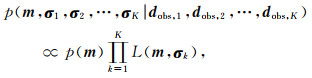
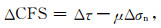
如图 2表示尼玛地震的同震干涉图,三个轨道监测到的同震影响范围均为~20 km×20 km,形变主要处于东部区域,主形变长轴约NE向.图 3表示LOS形变场,三个轨道的LOS形变场均显示以沉降为主,其中T12升轨LOS最大沉降量~30 cm,T121、T19降轨最大沉降量~26 cm,T12升轨西部区域存在部分抬升,最大抬升量~7 cm.图 3d表示横截面A-B对应三个轨道的LOS形变量变化曲线,LOS形变量主要集中在20 km范围内.此外,图中显示出不同机构确定的震中,红色五角星表示CENC确定的震中,靠近WMYC断裂.USGS、GCMT确定的震中均位于InSAR形变中心的南部,USGS距离较近.

|
图 2 尼玛地震的同震干涉图 (a) T12升轨;(b) T121降轨;(c) T19降轨. Fig. 2 Coseismic interferograms of Nima earthquake (a) T12 ascending track; (b) T121 descending track; (c) T19 descending track. |

|
图 3 尼玛地震LOS形变场 (a) T12升轨;(b) T121降轨;(c) T19降轨;(d) 截面分析.黑线、红线、白线分别表示不同轨道对应截面A-B的LOS形变量.白色、红色五角星分别代表InSAR和CENC确定的震中. Fig. 3 The LOS deformation field of Nima earthquake (a) T12 ascending track; (b) T121 descending track; (c) T19 descending track; (d) Cross section analysis. The black, red, and white lines respectively represent the LOS deformation of the corresponding section A-B of different tracks. White and red pentagrams indicate the hypocentral location determined by InSAR and CENC. |
为加快反演进程,本文采用四叉树算法对LOS形变场进行降采样处理(Jónsson et al., 2002),考虑到近场形变的重要性,设置不同的阈值,对近场形变进行加密采样,而对远场区域进行稀疏采样,这样既保留了近场的形变特征,又一定程度上减小了远场误差与噪声给反演带来的负面影响.最终得到数据点共计2348个,其中T12轨道775个,T121轨道853个,T19轨道720个.
2.1 断层几何形状反演本文利用基于序列蒙特卡罗(Sequential Monte Carlo, SMC)采样的贝叶斯方法(Bayesian Methods, BM)估算发震断层相关的几何形状参数(Vasyura-Bathke et al., 2020;Zheng et al., 2020).根据BM定义,模型参数的后验概率密度函数(posterior probability density function, PDF)p(m|dobs)可以表示为:
|
(1) |
其中m是待估计的参数,一般包含断层参数和超参数,dobs表示观测数据.
一般的,断层参数的求解属于非线性问题.对于K个数据集的每个子集dobs, k,我们假设一个带有误差的多元高斯分布来估计未知残差的分布,以此作为超参数(Fukuda and Johnson, 2008),PDF表示为:
|
(2) |
其中,d(m)表示数据集k的第Nk个静态或瞬态位移;Cxk表示结合有超参数σk的方差、协方差矩阵,作为不同数据集的权重,L(m, σk)表示为:

|
(3) |
断层几何反演的一般流程为:BM将断层作为一个均匀平面来处理,基于贝叶斯原理,利用SMC对数据集进行采样,优化得到断层参数(断层长、宽、走向、倾角、滑动角等).
本文观测数据采用T12、T121、T19轨道降采样后获取的数据,共2348个.利用8个CPU并行计算,设置1000个马尔科夫链(Markov chains, MCs),每个MCs采样100步,持续至24个阶段后计算完成,共2.4×10⁶次.对所有估计样本值进行排序,置信区间的下限取排序后的2.5个百分位数,置信区间的上限取排序后的97.5个百分位数,取两者之间的数值,得到各参数95%置信区间.断层几何参数1D和2D的PDF如图 4所示,表示模型参数的离散变化,观察到模型参数的最优值与贝叶斯估计的峰值具有很好的相关性.

|
图 4 2020尼玛地震矩形震源的1D和2D后验概率密度分布 直方图中红色直线和2D相关图中的红点表示最大后验解.在相关图中蓝色表示高概率区域. Fig. 4 1D and 2D PDF of a rectangular source for 2020 Nima earthquake The red vertical lines in the histograms and the red dot in the 2D correlation maps mark the maximum a-posterior (MAP) solution. In the correlation maps, blue colors are regions of high probability. |
最终得到各参数的最大后验解(maximuma-posterior solutions, MAP):东偏移(Easting shift)、北偏移(North shift)表示UTM坐标系下相对于参考点(86.86°E,33.09°N,即GCMT提供的震中位置)的偏移量,几何上表示断层上边界中心点,经坐标变换,即(86.872°E,33.188°N),对应深度(Depth)为4.937 km;断层长度为13.199 km,断层宽度5.095 km,滑动量1.468 m;断层走向、倾角、滑动角分别为:30.41°±1.25°、49.52°±1.06°、-71.27°±2.49°.详细参数信息见表 2.假设剪切模量为30 GPa,则最优断层几何模型对应的矩震级约为MW6.3.
|
|
表 2 反演的断层几何形状参数 Table 2 Inversion of fault geometry |
在反演断层几何参数时,得到的残差结果如图 5所示.图中浅灰散点表示采样点,矩形表示反演断层位置,其中黑色直线表示断层上边界.在靠近震中附近,视线向模型值与观测值基本一致.对于T12升轨,残差范围是-0.06~0.05 m,残差的均方根(Root Mean Square,RMS)为2.1 cm;对于T121降轨,残差范围是-0.03~0.03 m,残差RMS为1.0 cm;对于T19降轨,残差范围是-0.03~0.03 m,残差RMS为1.3 cm.综合来看,三个轨道数据的拟合效果都较好,表明断层几何形状反演结果是准确的.

|
图 5 东倾断层几何参数反演获得的视线向形变残差 (a)、(b)、(c)分别为T12轨道形变值、模型值、残差;(d)、(e)、(f)分别为T121轨道形变值、模型值、残差;(g)、(h)、(i)分别为T19轨道形变值、模型值、残差. Fig. 5 LOS deformation residuals of East-dipping fault geometry inversion (a), (b) and (c) represent observation, model value and residual value of T12, respectively. (d), (e) and (f) represent observation, model value and residual value of T121, respectively. (g), (h) and (i) represent observation, model value and residual value of T19, respectively. |
一般的,反演断层滑动分布相当于求解线性问题的最优值.在已知断层模型的基础上,把断层离散为若干子断层,目标是解算每个子断层对应的滑动分布.断层位错而引起的地表变形通过弹性位错公式计算,在具体求解过程中通过最速下降法(Steepest Descent Methods, SDM)寻求观测值拟合度和滑动分布粗糙度之间的最优解(Wang et al., 2011):

|
(4) |
式中d为观测值;G是格林函数,通过基于半无限空间地壳分层的弹性位错模型计算获取;α是平滑因子,通过折中曲线(trade-off curve)获取.L表示位移权重因子和拉普拉斯算子有限差分近似;s为子断层的滑动量.
参考SMC得到的结果(表 2),在反演断层滑动分布之前,对断层参数进行初始化设置:走向取30.41°,倾角取49.52°,延伸断层的长宽,设置断层长32 km,宽22 km,各子断层大小为1 km×1 km.本文利用降采样的数据反演尼玛地震滑动分布,与前面反演断层几何参数所使用的数据保持一致,共计2348个.
如图 6所示表示同震滑动分布,结果显示破裂最大埋深~13.3 km,存在一个主要破裂区,其长度~15 km,宽度~10 km,主要破裂区集中在深度3.4~11.8 km,最大滑动量~0.98 m.平均滑动角为-74.54°,表明同震破裂主要表现为正断特征,且兼具少量左旋走滑性质.解算出震中位置为(86.89°E,33.18°N),对应深度7.23 km.假设地壳的剪切模量为30 GPa,此次地震释放的地震矩约为3.86×10¹⁸N·m,对应矩震级MW6.36,略大于USGS提供的震级.不同机构提供的断层参数见表 3.通过比较,InSAR反演的震中位置距离CENC确定的震中位置较近,位于其右侧,处于LOS形变中心附近(图 3).USGS、GCMT均位于InSAR确定震中的南侧.

|
图 6 利用InSAR数据反演尼玛地震的同震滑动分布 Fig. 6 Coseismic slip distribution of Nima earthquake inverted by InSAR |
|
|
表 3 震源参数比较 Table 3 Focal parameters comparison |
滑动分布模型的拟合残差如图 7所示,对于T12升轨,残差范围是-0.05~0.06 m,残差RMS为1.9 cm;对于T121降轨,残差范围是-0.05~0.03 m,残差RMS为2.3 cm;对于T19降轨,残差范围是-0.04~0.05 m,残差RMS为1.8 cm.模拟值均能较好的代表观测值,表明反演得到的滑动分布是可靠的.

|
图 7 东倾断层滑动分布模型的形变残差 (a)、(b)、(c) 分别表示T12升轨、T121降轨、T19降轨拟合的残差. Fig. 7 The deformation residuals of the distributed slip model of the East-dipping fault (a), (b) and (c) represent the residuals value of T12, T121 and T19, respectively. |
为论证上述断层倾向的准确性,通过比较不同倾向断层模型的模拟效果来进行判断.本文对断层相关参数进行约束(走向:90°~270°),反演得到西倾型断层参数,断层走向、倾角、滑动角分别为:203.70°±0.54°、40.58°±0.48°、-93.36°±1.66°,反演效果及残差如图 8所示,对于T12升轨,残差范围是-0.09~0.06 m,残差RMS为2.5 cm;对于T121降轨,残差范围是-0.03~0.03 m,残差RMS为1.0 cm;对于T19降轨,残差范围是-0.03~0.04 m,残差RMS为1.4 cm.依据西倾断层参数,通过SDM反演同震滑动分布如图 9所示,对应轨道的拟合残差如图 10所示,对于T12升轨,残差范围是-0.12~0.09 m,残差RMS为4.0 cm;对于T121降轨,残差范围是-0.06~0.04 m,残差RMS为2.4 cm;对于T19降轨,残差范围是-0.05~0.05 m,残差RMS为2.1 cm.与东倾断层拟合残差(图 5、图 7)相比,T121降轨、T19降轨的拟合效果相差较小,但对于T12升轨的拟合效果,东倾断层明显优于西倾断层.因此,本文认为发震断层为正断的东倾断层.

|
图 8 西倾断层几何参数反演获得的视线向形变残差 (a)、(b)、(c)分别为T12轨道形变值、模型值、残差;(d)、(e)、(f)分别为T121轨道形变值、模型值、残差;(g)、(h)、(i)分别为T19轨道形变值、模型值、残差. Fig. 8 LOS deformation residuals of West-dipping fault geometry inversion (a), (b) and (c) represent observation, model value and residual value of T12, respectively. (d), (e) and (f) represent observation, model value and residual value of T121, respectively. (g), (h) and (i) represent observation, model value and residual value of T19, respectively. |

|
图 9 西倾断层的同震滑动分布 Fig. 9 The coseismic slip distribution of the West-dipping fault |

|
图 10 西倾断层同震滑动分布模型的形变残差 (a)、(b)、(c)分别表示T12升轨、T121降轨、T19降轨拟合的残差. Fig. 10 The deformation residuals of the coseismic slip distribution model of the West-dipping fault (a), (b) and (c) represent the residuals value of T12, T121 and T19, respectively. |
2020年中国大陆活动频繁,陆续发生了伽师MW6.0地震、定日MW5.7地震、于田MW6.3地震以及本次尼玛MW6.3地震.此次地震发生在羌塘块体中部的依布茶卡盆地,为评估对尼玛地区带来的影响,假设摩擦系数为0.4,接收断层的走向30.41°,倾角49.52°,滑动角-71.27°(即上述反演得到的断层几何参数,见表 2),基于crust 1.0分层的弹性半空间模型和SDM反演的同震滑动分布,利用PSGRN/PSCMP软件分别计算深度5 km、10 km、15 km、20 km所对应的库仑破裂应力变化(The Coulomb failure stress change, ΔCFS)(King et al., 1994;Wang et al., 2006):
|
(5) |
其中ΔCFS表示特定接收断层上的库仑应力变化;Δτ表示沿着断层滑动方向剪应力的变化量;μ表示有效摩擦系数,一般取值范围0~1;Δσn表示断层面上正应力的变化量.ΔCFS>0表示库仑破裂应力增加,用暖色调显示,ΔCFS < 0表示库仑破裂应力减少,用冷色调显示,当ΔCFS≥0.01 MPa时,就有诱发地震的可能(Ziv and Rubin, 2000).
如图 11表示ΔCFS,此次尼玛MW6.3地震产生的同震影响主要分为两个方向:一个是近南北向,主要对依布茶卡盆地西缘断裂以及依布茶卡-日干配错断裂部分区域表现为库仑应力增加,随着深度的变化而变化.另一个是近东西向,表现为库仑应力减少,且随着深度的增加,影响范围明显减少.

|
图 11 不同深度下主震接收断层的同震库仑破裂应力变化图 黑色点表示M 3~4余震,绿色点表示M 4~5余震. Fig. 11 The map of coseismic Coulomb failure stress changes with the receiving fault of the mainshock at different depths Black points represent M 3~4 aftershocks and green points represent M 4~5 aftershocks. |
据中国地震信息网统计(http://www.csi.ac.cn/),主震发生一个月内,共计发生13次3 < M < 5余震,最大余震M4.8,余震深度范围为6~10 km.余震围绕震中呈现近椭球状分布.图中库仑应力增量超过0.01 MPa的区域值得后续更多关注,其中对于震中南部ΔCFS>0的区域,诱发了众多余震,应力得到部分释放;而震中北部的WMYC,目前仅发生一个M4.3余震.对于ΔCFS达到0.01 MPa的部分区域,如果其处于应力集中状态且接近临界值,那么未来这些区域的地震危险性都将大大提高.特别是对于深度5 km和10 km位于破裂区南北端,以及深度15 km和20 km位于破裂区东西侧,其ΔCFS≥0.01 MPa,均存在发生地震的可能性,值得后续关注.
3.3 2008年改则MW6.4地震产生的影响此次尼玛地震位于两大断裂依布茶卡盆地西缘断裂和依布茶卡-日干配错断裂附近,从图 1可以看出该区域近几十年来历史地震活动性较弱,本次地震方圆200 km内发生的最近且最大的地震是2008年1月9日改则MW6.4地震,空间上距离此次尼玛地震震中约170 km,发生在依布茶卡-日干配错断裂的南部.Elliott等(2010)通过InSAR反演得到2008年改则MW6.4地震的发震断层几何参数:走向223°、倾角51°、滑动角-67°,并提供了详细的滑动分布.在此基础上,我们利用PSGRN/PSCMP软件(Wang et al., 2006),接收断层取本次地震反演的断层几何参数(走向30.41°,倾角49.52°,滑动角-71.27°),以本次反演的尼玛地震震中为参考点(86.89°E,33.18°N),岩石圈分层参数参考熊维等(2015)模型一的结果,采用线性的麦克斯韦体,通过计算2008年改则地震对此次地震震中造成的同震和震后ΔCFS,以此定性评估带来的影响.
考虑到摩擦系数的影响,本文进行了简单的讨论,摩擦系数分别取0.2、0.4、0.6、0.8.结果如图 12所示,表示2008年改则地震对此次尼玛地震震中不同深度的影响,以同震和震后产生的累计ΔCFS为衡量标准,曲线数值随着摩擦系数增大而增大.截至2020年7月22日(UTC)尼玛MW6.3地震发生时,对于深度0 km、5 km、10 km、15 km,ΔCFS随着时间的增加而不断增加,其中深度10 km和15 km对应的曲线数值较大,但最大ΔCFS均不足1.5×10⁻⁴ MPa,远小于诱发地震临界值0.01 MPa(Stein, 1999);对于深度20 km、25 km、30 km,ΔCFS随着时间的增加而不断减小.综上,本文认为2008年改则MW6.4地震对本次尼玛地震的影响很小.

|
图 12 不同深度下,2008年改则MW6.4地震引起2020年尼玛MW6.3地震震中ΔCFS的时间变化曲线 两条虚线分别表示2008年改则MW6.4和2020年尼玛MW6.3地震的发震时刻.(a)、(b)、(c)、(d)分别对应摩擦系数0.2、0.4、0.6和0.8. Fig. 12 At different depths, the time change curve of ΔCFS at the hypocenter of the 2020 Nima MW6.3 earthquake caused by the 2008 Gerze MW6.4 earthquake The two dashed lines respectively indicate the time of the 2008 Gerze MW6.4 and 2020 Nima MW6.3 earthquakes. (a), (b), (c) and (d) represent friction coefficients 0.2, 0.4, 0.6 and 0.8, respectively. |
本文利用Sentinel-1A/B干涉宽幅数据,获取2020年7月22日(UTC)尼玛地震的同震形变场,并采用SMC和SDM方法,反演断层几何形状参数和同震破裂滑动分布,得到以下几点认识:
(1) 尼玛地震T12升轨、T121降轨、T19降轨LOS形变场均显示以沉降为主,其中T12升轨LOS最大沉降量~30 cm,T121、T19降轨最大沉降量~26 cm,T12升轨的西部区域存在部分抬升,最大抬升量~7 cm.
(2) 断层几何参数反演显示,发震断层走向~30.41°±1.25°,倾角~49.52°±1.06°.
(3) 反演的断层滑动分布表明,尼玛地震主要破裂区集中在3.4~11.8 km深度.存在一个滑动中心,最大滑动量~0.98 m,反演的震中位置为(86.89°E,33.18°N),对应深度7.23 km.平均滑动角为-74.54°,表明本次地震是以正断拉张为主兼具少量左旋走滑.假设地壳的剪切模量为30 GPa,此次地震释放的地震矩约为3.86×10¹⁸N·m,对应矩震级MW6.36,略大于USGS提供的震级.
(4) 本文通过对比东倾与西倾断层模型的拟合效果,判定发震断层为正断的东倾断层.
(5) 对于深度5 km和10 km位于破裂区南北端,以及深度15 km和20 km位于破裂区东西侧,其ΔCFS≥0.01 MPa,未来危险性值得更多的关注.
(6) 通过估算2008年改则MW6.4地震的同震和震后对此次地震震中造成的ΔCFS,得出2008年改则MW6.4地震对此次2020年尼玛MW6.3地震的影响很小.
致谢 感谢欧洲空间局(ESA)提供Sentinel-1卫星升降轨SAR数据.感谢汪荣江老师提供的SDM、PSGRN/PSCMP软件.感谢审稿专家提出的宝贵意见.
Bagnardi M, Hooper A. 2018. Inversion of surface deformation data for rapid estimates of source parameters and uncertainties: a Bayesian approach. Geochemistry, Geophysics, Geosystems, 19(7): 2194-2211. DOI:10.1029/2018GC007585 |
Chen C W, Zebker H A. 2002. Phase unwrapping for large SAR interferograms: statistical segmentation and generalized network models. IEEE Transactions on Geoscience and Remote Sensing, 40(8): 1709-1719. DOI:10.1109/TGRS.2002.802453 |
Elliott J R, Walters R J, England P C, et al. 2010. Extension on the Tibetan plateau: recent normal faulting measured by InSAR and body wave seismology. Geophysical Journal International, 183(2): 503-535. DOI:10.1111/j.1365-246X.2010.04754.x |
Farr T G, Rosen P A, Caro E, et al. 2007. The shuttle radar topography mission. Reviews of Geophysics, 45(2): RG2004. DOI:10.1029/2005RG000183 |
Feng G C, Li Z W, Xu B, et al. 2016. Coseismic deformation of the 2015 MW6.4 Pishan, China, earthquake estimated from Sentinel-1A and ALOS2 data. Seismological Research Letters, 87(4): 800-806. DOI:10.1785/0220150264 |
Feng W P, Li Z H. 2010. A novel hybrid PSO/simplex algorithm for determining earthquake source parameters using InSAR data. Progress in Geophysics (in Chinese), 25(4): 1189-1196. DOI:10.3969/j.issn.1004-2903.2010.04.007 |
Fukuda J, Johnson K M. 2008. A fully Bayesian inversion for spatial distribution of fault slip with objective smoothing. Bulletin of the Seismological Society of America, 98(3): 1128-1146. DOI:10.1785/0120070194 |
Goldstein R M, Werner C L. 1998. Radar interferogram filtering for geophysical applications. Geophysical Research Letters, 25(21): 4035-4038. DOI:10.1029/1998GL900033 |
Hong S Y, Zhou X, Zhang K, et al. 2018. Source model and stress disturbance of the 2017 Jiuzhaigou MW6.5 earthquake constrained by InSAR and GPS measurements. Remote Sensing, 10(9): 1400. DOI:10.3390/rs10091400 |
Hu J J, Li Q, Li J, et al. 2016. Geochemical characteristics and depositional environment of the Middle Permian mudstones from central Qiangtang Basin, northern Tibet. Geological Journal, 51(4): 560-571. DOI:10.1002/gj.2653 |
Huang Z C, Zhang G H, Shan X J, et al. 2019. Co-seismic deformation and fault slip model of the 2017 MW7.3 Darbandikhan, Iran-Iraq earthquake inferred from D-InSAR measurements. Remote Sensing, 11(21): 2521. DOI:10.3390/rs11212521 |
Jónsson S, Zebker H, Segall P, et al. 2002. Fault slip distribution of the 1999 MW7.1 hector Mine, California, earthquake, estimated from satellite radar and GPS measurements. Bulletin of the Seismological Society of America, 92(4): 1377-1389. DOI:10.1785/0120000922 |
King G C, Stein R S, Lin J. 1994. Static stress changes and the triggering of earthquakes. Bulletin of the Seismological Society of America, 84(3): 935-953. |
Li D, Wang G H, Gao J H, et al. 2019. The continental subduction in the evolution of central Qiangtang mélange belt and its tectonic significance. International Geology Review, 61(9): 1143-1170. DOI:10.1080/00206814.2018.1499450 |
Li J C, Zhao Z B, Zheng Y L, et al. 2015. The magmatite evidences in southern Qiangtang for paleo-Tethys ocean subducting collision: Gangtang-co granites in Rongma, Tibet. Acta Petrologica Sinica (in Chinese), 31(7): 2078-2088. |
Moral P D, Doucet A, Jasra A. 2006. Sequential Monte Carlo samplers. Journal of the Royal Statistical Society, 68(3): 411-436. DOI:10.1111/j.1467-9868.2006.00553.x |
Rosen P A, Gurrola E, Sacco G F, et al. 2012. The InSAR scientific computing environment. //EUSAR 2012; 9th European Conference on Synthetic Aperture Radar. Nuremberg, Germany: IEEE, 730-733.
|
Shan X J, Qu C Y, Gong W Y, et al. 2017. Coseismic deformation field of the Jiuzhaigou MS7.0 earthquake from Sentinel-1A InSAR data and fault slip inversion. Chinese Journal of Geophysics (in Chinese), 60(12): 4527-4536. DOI:10.6038/cjg20171201 |
Stein R S. 1999. The role of stress transfer in earthquake occurrence. Nature, 402(6762): 605-609. DOI:10.1038/45144 |
Tan K, Qiao X J, You X Z, et al. 2009. Modeling InSAR coseismic deformation field caused by Gaize MS6.9 earthquake in 2008. Journal of Geodesy and Geodynamics (in Chinese), 29(S1): 1-6. |
Tan K, Wang Q, Ding K H, et al. 2015. Rupture models of the 2013 Lushan earthquake constrained by near field displacements and its tectonic implications. Chinese Journal of Geophysics (in Chinese), 58(9): 3169-3182. DOI:10.6038/cjg20150913 |
Vasyura-Bathke H, Dettmer J, Steinberg A, et al. 2020. The Bayesian earthquake analysis tool. Seismological Research Letters, 91(2A): 1003-1018. DOI:10.1785/0220190075 |
Wang C, Mouche A, Tandeo P, et al. 2019. A labelled ocean SAR imagery dataset of ten geophysical phenomena from Sentinel-1 wave mode. Geoscience Data Journal, 6(2): 105-115. DOI:10.1002/gdj3.73 |
Wang C S, Wang X Y, Xiu W Q, et al. 2020. Characteristics of the seismogenic faults in the 2018 Lombok, Indonesia, earthquake sequence as revealed by inversion of InSAR measurements. Seismological Research Letters, 91(2A): 733-744. DOI:10.1785/0220190002 |
Wang R, Schurr B, Milkereit C, et al. 2011. An improved automatic scheme for empirical baseline correction of digital strong-motion records. Bulletin of the Seismological Society of America, 101(5): 2029-2044. DOI:10.1785/0120110039 |
Wang R J, Lorenzo-Martín F, Roth F. 2006. PSGRN/PSCMP-a new code for calculation co- and post-seismic deformation, geoid and gravity changes based on the viscoelastic-gravitational dislocation theory. Computers & Geosciences, 32(4): 527-541. |
Xiong W, Tan K, Liu G, et al. 2015. Coseismic and postseismic Coulomb stress changes on surrounding major faults caused by the 2015 Nepal MW7.9 earthquake. Chinese Journal of Geophysics (in Chinese), 58(11): 4305-4316. DOI:10.6038/cjg20151135 |
Xu C J, Lin D L, Wen Y M. 2010. Extract and analysis surface deformation caused by Wenchuan MW7.9 earthquake from InSAR data. Geomatics and Information Science of Wuhan University (in Chinese), 35(10): 1138-1142. |
Yang J Y, Xu C J, Wang S, et al. 2020. Sentinel-1 observation of 2019 MW5.7 Acipayam earthquake: A blind normal-faulting event in the Acipayam basin, southwestern Turkey. Journal of Geodynamics, 135: 101707. DOI:10.1016/j.jog.2020.101707 |
Yu C, Penna N T, Li Z H. 2017. Generation of real-time mode high-resolution water vapor fields from GPS observations. Journal of Geophysical Research: Atmospheres, 122(3): 2008-2025. DOI:10.1002/2016JD025753 |
Yu C, Li Z H, Penna N T. 2018. Interferometric synthetic aperture radar atmospheric correction using a GPS-based iterative tropospheric decomposition model. Remote Sensing of Environment, 204: 109-121. DOI:10.1016/j.rse.2017.10.038 |
Zhang P Z, Deng Q D, Zhang G M, et al. 2003. Active tectonic blocks and strong earthquakes in the continent of China. Science in China Series D: Earth Sciences, 46(2): 13-24. |
Zhao Z B, Bons P D, Wang G H, et al. 2014. Origin and pre-Cenozoic evolution of the south Qiangtang basement, Central Tibet. Tectonophysics, 623: 52-66. DOI:10.1016/j.tecto.2014.03.016 |
Zheng A, Yu X W, Xu W B, et al. 2020. A hybrid source mechanism of the 2017 MW6.5 Jiuzhaigou earthquake revealed by the joint inversion of strong-motion, teleseismic and InSAR data. Tectonophysics, 789: 228538. DOI:10.1016/j.tecto.2020.228538 |
Ziv A, Rubin A M. 2000. Static stress transfer and earthquake triggering: No lower threshold in sight?. Journal of Geophysical Research: Solid Earth, 105(B6): 13631-13642. DOI:10.1029/2000JB900081 |
冯万鹏, 李振洪. 2010. InSAR资料约束下震源参数的PSO混合算法反演策略. 地球物理学进展, 25(4): 1189-1196. DOI:10.3969/j.issn.1004-2903.2010.04.007 |
李静超, 赵中宝, 郑艺龙, 等. 2015. 古特提斯洋俯冲碰撞在南羌塘的岩浆岩证据: 西藏荣玛乡冈塘错花岗岩. 岩石学报, 31(7): 2078-2088. |
单新建, 屈春燕, 龚文瑜, 等. 2017. 2017年8月8日四川九寨沟7.0级地震InSAR同震形变场及断层滑动分布反演. 地球物理学报, 60(12): 4527-4536. DOI:10.6038/cjg20171201 |
谭凯, 乔学军, 游新兆, 等. 2009. 改则MS6.9地震InSAR同震形变场模拟. 大地测量与地球动力学, 29(S1): 1-6. |
谭凯, 王琪, 丁开华, 等. 2015. 近场位移数据约束的2013年芦山地震破裂模型及其构造意义. 地球物理学报, 58(9): 3169-3182. DOI:10.6038/cjg20150913 |
熊维, 谭凯, 刘刚, 等. 2015. 2015年尼泊尔MW7.9地震对青藏高原活动断裂同震、震后应力影响. 地球物理学报, 58(11): 4305-4316. DOI:10.6038/cjg20151135 |
许才军, 林敦灵, 温扬茂. 2010. 利用InSAR数据的汶川地震形变场提取及分析. 武汉大学学报·信息科学版, 35(10): 1138-1142. |
张培震, 邓启东, 张国民, 等. 2003. 中国大陆的强震活动与活动地块. 中国科学(D辑), 33(S1): 12-20. |