2. 东华理工大学 测绘工程学院, 南昌 330013;
3. 中国地震台网中心, 北京 100045;
4. 中国地震第二监测中心, 西安 710054;
5. 河北省地震局河北地震台, 石家庄 050021
2. Faculty of Geomatics, East China University of Technology, Nanchang 330013, China;
3. China Earthquake Network Center, Beijing 100045, China;
4. The Second Monitoring and Application Center, Xi'an 710054, China;
5. Hebei Earthquake Agency, Shijiazhuang 050021, China
北京时间2021年5月21日21点48分(UTC 2021-05-21 13:48:37),我国云南大理白族自治州漾濞彝族自治县发生MS6.4强震,造成3人死亡和部分房屋严重受损.据中国地震台网测定,震中位于25.67°N,99.87°E,震源深度8 km.本次地震序列呈现典型的前震-主震-余震类型:在主震前后的一周内(5月18日至5月24日)共发生MS≥3.0地震42次,其中,主震前约27 min和25 min,分别发生了MS5.6和MS4.5前震;主震后,分别在21:55和22:31发生MS5.0和MS5.3余震.
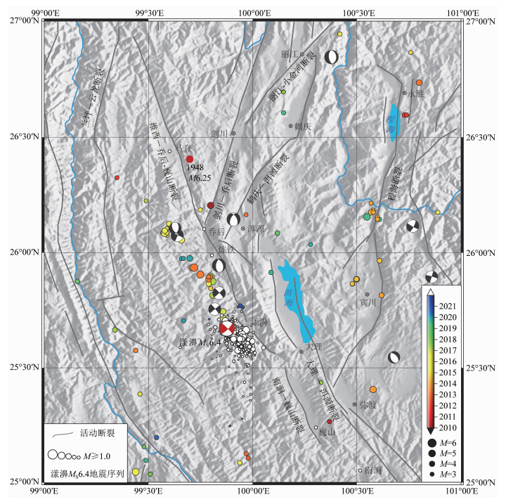
地震发生后,国内外科研机构和学者(如USGS,globalcmt,中国地震局地球物理研究所http://www.cea-igp.ac.cn/kydt/278248.html; 王卫民等, 2021, 个人通讯; Yang et al., 2021)基于全球远场地震波和(或)云南区域地震台网观测资料,快速确定了震中位置、震源机制解以及前震和余震的空间展布,为快速判定发震断层及震情跟踪提供了宝贵的基础资料.其中,震前3天和震后6天的地震重定位结果(Yang et al., 2021)表明,此次地震的前-主-余震序列大致沿维西—乔后—巍山断裂的西侧呈北西向条带状分布,长约20 km,震源深度主要分布在12 km以上,余震集中分布于主震的东南方向(http://www.cea-igp.ac.cn/cxdt278268.html/)(图 1).主震震源机制解和前震-主震-余震的空间展布特征表明,本次地震破裂呈现出北西-南东向的高倾角右旋走滑特征,据此初步判定发震断层为维西—乔后—巍山断裂或与其直接相关的分支断裂.然而,震后地质调查未发现明显的地表破裂,维西—乔后断裂在此次地震过程中并未活动(https://www.eq-igl.ac.cn/zhxw/info/2021/33882.html).
|
图 1 滇西北大理地区活动构造及地震分布示意图 1976年以来的历史强震用震源机制解沙滩球符号表示(来自www.globalcmt.org).漾濞MS6.4地震周边密集分布的中小地震为5月24日之前的前震-余震(数据来自Yang et al., 2021).活动构造资料源自中国地震局地质研究所活断层数据库. Fig. 1 Active faults and historic earthquakes in Dali, northwest Yunnan province The beach balls represent focal mechanisms of major earthquakes since 1976 (www.globalcmt.org). The red beach ball denotes Yangbi MS6.4 mainshock, and the dense white circles denote foreshocks and aftershocks before May 24 (Earthquake catalog is from Yang et al., 2021). The fault data are collected from active fault database compiled by the Institute of Geology, China Earthquake Administration. |
维西—乔后—巍山断裂是红河断裂带向北弥散延伸的分支断裂之一,向北与金沙江断裂相接,向南与狭义的红河断裂相连,是川滇菱形块体西南边界的重要组成部分(常祖峰等, 2016;任俊杰等, 2007; 图 1).川滇菱形块体地处青藏高原东南缘,受高原物质东向逃逸的强烈推挤,其边界断裂似乎理应承纳强烈的构造变形和地震潜能(Allen et al., 1984; Replumaz et al., 2001),但现今的实际状况是北东边界(甘孜—玉树—鲜水河—安宁河—小江断裂带)活动强烈、强震频发(如Wen et al., 2008, 2011; 闻学泽等, 2011; 程佳等, 2011, 2012;徐晶等, 2019),而西南边界(金沙江—红河断裂带)活动微弱、强震稀疏(如虢顺民等,2013;Li et al., 2020).
具体而言,甘孜—玉树—鲜水河断裂的滑动速率,无论是第四纪或全新世的长期均值,还是现今GPS的观测量值,均高达~10 mm·a-1(Gan et al., 2007;Wang和Shen, 2020; 王阎昭等, 2008; Wang et al., 1998, 2017),与此相应的地震事件,更是频发——在过去的700百年间,共发生3次8级大地震和至少18次7级以上地震(Wen et al., 2008; 程佳等, 2011, 2012;徐晶等, 2019).而红河断裂带尽管在构造地貌上存在着一系列引人注目的断错——累积右旋错距达~25 km(Replumaz et al., 2001), ~40 km(Schoenbohm et al., 2006), 或20~54 km(Wang et al., 1998),但现今GPS观测所得的右旋滑动速率仅约2~3 mm·a-1(Shen et al., 2005; 王阎昭等, 2008; Wang和Shen, 2020;Li et al., 2020),地质学方法推测的第四纪和千年尺度的平均速率亦仅1~3 mm·a-1(Shi et al., 2018; 虢顺民等, 2013).至于地震事件,根据历史地震目录,红河断裂带在过去600年间发生的6级以上地震不足20次(虢顺民等, 1984; 尹凤玲等, 2018),且主要发生在红河断裂北段弥散的一系列分支断裂上,红河断裂的中南段则鲜有强震发生(李西等,2016;虢顺民等,2013).因此,关于川滇菱形块体西南边界带是否依然发挥重要作用,以及其现今的强震孕育水平或地震危险性潜势到底如何,一直存在着较大的争议.但是,对于以下两点结论却有一致的共识:其一,川滇菱形块体西南边界现今断裂滑动速率较低;其二,构造变形和强震活动并非集中在红河断裂主干,而是呈现出弥散分布特征(Li et al., 2020; Shen et al., 2005; Zhang et al., 2004).不过,鉴于川滇菱形块体整体所处的强构造变形环境,人们对其西南边界的地震危险性潜势,并未因其断裂变形的弥散和滑动速率较弱而予以轻视(Allen et al., 1984; Replumaz et al., 2001; 虢顺民等, 1984, 2013; Zhang, 2013; 尹凤玲等, 2018; Li et al., 2020).
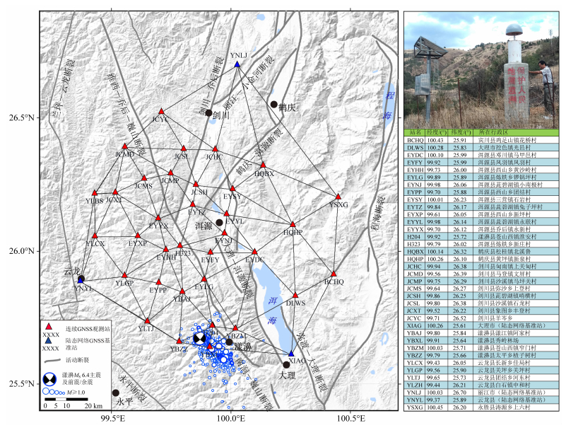
当聚焦于红河断裂带北段的维西—乔后—巍山断裂及其周边,人们发现在近十余年来该区域中-小地震活动呈持续增强态势,例如在乔后盆地和炼铁盆地附近,曾先后发生了2013年洱源5.5级震群(常祖峰等, 2014; 赵小艳和付虹, 2014; 杨军等, 2015; 黄小龙等, 2015)和2017年5.1级震群(潘睿等, 2019),再加之近代历史上该区域曾先后发生过1925年南涧和1948年马登6级以上地震(图 1),故中国地震局近年来将其列入了地震危险性强化跟踪监测区而予以重点关注.为此,自2017年以来,在财政部修缮购置项目和国家重点研发项目“地震亚失稳阶段识别的实验、理论与野外观测研究”的大力支持下,我们在该区域已有的国家地震监测台网的基础上,加密布设了3种高密度“地震亚失稳研究”观测台网,包括测震、GNSS大地测量和基岩温度等观测技术,其中的GNSS大地测量子项,建设成了迄今国内乃至国际上最高密度的“大理连续GNSS观测台阵”(图 2),旨在精细观测地震亚失稳过程中地壳形变的时-空变化特征,以期捕获地震亚失稳(短临)阶段可能的地壳形变异常或前兆(马瑾等, 2012; 马瑾和郭彦双, 2014).
|
图 2 云南大理高密度连续GNSS观测台阵站点分布图及站点信息 右上角为此台阵的典型GNSS观测站.侧表列出了观测站的坐标及行政区所在.蓝色三角形为中国大陆构造环境监测网络基准站. Fig. 2 Station distribution and information of Dali dense continuous GNSS array in Yunnan province Right-top picture shows details of GNSS station. Table in the right panel shows location of the each GNSS station. Blue triangles denote continuous GNSS stations of Tectonic and Environmental Observation Network of China. |
本次地震发生在“大理连续GNSS观测台阵”的南缘内侧,作为一个典型的前震-主震-余震型强震序列,为我们开展地震亚失稳的野外现场观测研究提供了极为重要的震例.本文将展示基于这一高密度连续GNSS台阵所观测的漾濞MS6.4强震的三维同震位移场,并以此为约束,反演推测地震破裂的滑动分布,以期为更好地认识本次地震的发震断裂、发生机理和破裂模式等提供翔实的基础资料.
1 GNSS观测台阵及GNSS数据处理大理连续GNSS观测台阵布设在以洱源县城为中心的~50 km区域范围内,包含有3个“中国大陆构造环境监测网络”(“陆态网络”)国家级基准站和34个本项目自主加密GNSS观测站,平均站间距小于15 km(图 2).其中,陆态网络的3个站(云龙站YNYL、下关站XIAG、丽江站YNLJ)于2010年之前建成.自主加密的34个站陆续在2018年3月至2020年7月间建成.各观测站的坐落位置详见图 2.本次漾濞MS6.4地震发生在GNSS观测网正南部,离地震最近的3个观测站YBXL(漾濞县秀岭林场)、H204(漾濞县淮安村)和YBZZ(漾濞县太平乡)的震中距分别为5.8 km、7.5 km和8.6 km,最远观测站JCYC(剑川县羊岑乡)的震中距约为100 km.
对于30 s采样率的静态GNSS观测数据处理,我们采用了国际上的常用策略之一:首先采用美国航空航天局喷气推进实验室(JPL, NASA)的GIPSY/OASIS(版本6.0)(Webb和Zumberge, 1993)软件和PPP(精密单点定位)模式(Zumberge et al., 1997)进行每日24 h时段的严密处理,获得单日坐标松弛约束解;然后,采用st_filter (Spatio-Temporal Filtering)(QOCA的升级版)(Dong et al., 2006),对所有站点的单日松弛约束解进行联合求解,形成一套内部自洽的统一解;最后,利用单日松弛约束解中的公共参数(部分IGS全球地面跟踪参考站坐标,公共卫星轨道),把所有本地站点的单日解通过6参数Helmert转换,整体旋转、平移至统一的ITRF 2014(International Terrestrial Reference Frame; Altamimi et al., 2017)参考框架中,获得各站点的坐标变化时间序列.其中的一些关键要点如下:
以消除电离层影响的线性组合作为观测量,卫星截止高度角设置为15°,数据采样率30 s,采用并固定JPL精密星历和时钟(ftp://sideshow.jpl.nasa.gov)
(b) 先验对流层干延迟模型和对流层投影函数分别选取全球大气压-温度模型GPT2和GMF(Boehm et al., 2006);
海洋潮汐影响改正由FES2004海洋潮汐模型基于格林函数在线计算获得(http://holt.oso.chalmers.se/loading);
(d) 处理过程中考虑星历、钟差、仪器偏差(DCB)、接收机天线相位中心和卫星相位中心等产品的自洽性(Schmid et al.,2007);
(e) 估计参数除观测站坐标外,还包括对流层延迟,并采用单站模糊度PPP固定方法(Bertiger et al., 2010),结合IGS全球地面跟踪参考站提供的实数模糊度组成双差,实现双差模糊度的固定,并利用双差模糊度的整数约束条件,获得PPP模糊度固定解.
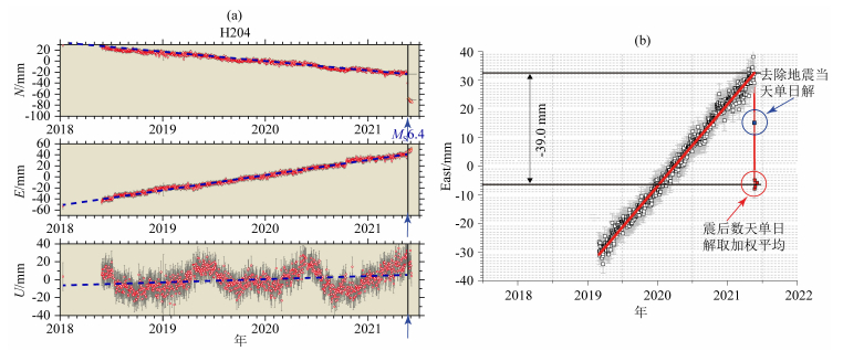
2 GNSS同震位移场我们采用最小二乘方法,对震前(2~3年)和震后数天(至少3~4天)三分量(东向、北向和垂向)坐标变化时间序列分别进行分段线性拟合,获得各测站的震前线性运动速率和同震位移(图 3a).考虑到地震对同一天观测数据有较大影响,我们在同震位移的估算过程中,去除了发震当天的单日解结果(图 3b).
|
图 3 典型GNSS观测站坐标变化时间序列及据此获取同震位移的策略示意 (a)一个观测站(H204)的三维坐标单日解时间序列,其中,地震产生的同震位移显而易见; (b)基于坐标变化序列分量确定同震位移分量的策略示意. Fig. 3 Daily coordinate solution time series of a typical GNSS station and a schematic diagram showing the strategy to estimate the coseismic offsets (a) Daily coordinate solution time series of site H204 as example, in which the coseismic offset in North component is obvious; (b) Schematic diagram showing the strategy to estimate the coseismic offset of a component. |
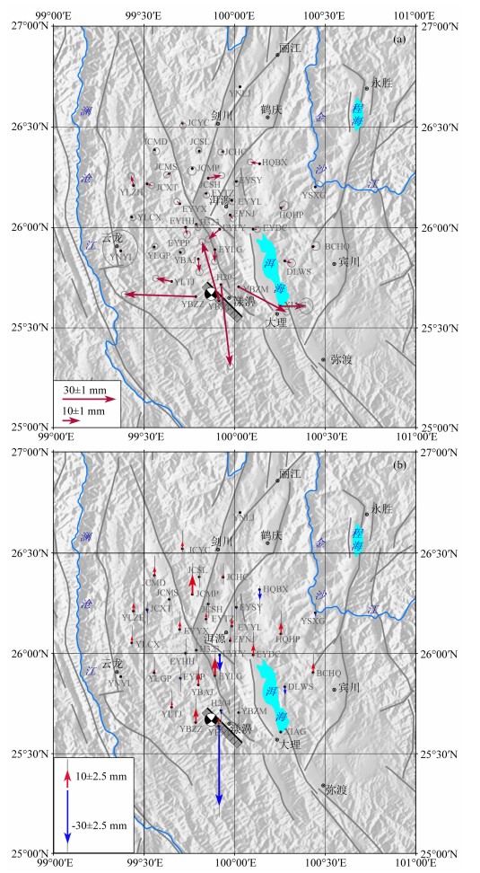
图 4和表 1给出了大理连续GNSS观测台阵三维同震位移结果.图 4a显示,水平位移主要发生在震中距50 km范围内,且量值随震中距的增大而快速衰减.震中距20 km范围内的4个测站H204、YBXL、YBZZ、YBZM的水平位移量最大.其中,H204测站的东西向位移为5.3±0.3 mm、南北向位移为-45.8±0.3 mm;YBXL东西向位移-9.4±0.3 mm、南北向位移33.0±0.4 mm;YBZZ东西向位移-40.0±0.2 mm,南北向位移1.3±0.3 mm;YBZM向东运动,其东西向位移26.9±0.3 mm,南北向位移-14.2±0.5 mm.
|
图 4 GNSS观测获得的同震位移场 (a)水平同震位移; (b)垂向同震位移. Fig. 4 Coseismic offsets derived from GNSS observations (a) Horizontal coseismic displacements; (b) Vertical coseismic displacements. |
|
|
表 1 漾濞MS6.4地震造成的GNSS观测站三维同震位移 Table 1 Three-dimensional coseismic displacements of Yangbi MS6.4 Earthquake observed from GNSS |
震中距50 km范围内的近场测站的水平位移表现出明显的分区特征:主震序列南侧站点(YBXL、YBZZ和YLTJ)向北西向或西向运动,北侧站点(H204、YBZM、YBAJ、EYLG、XIAG)向南、南东、东向运动.这种变形分区特征与震源机制解给出的北西向节面右旋走滑特征相符,由此可以推测:a)发震断层具有明显右旋走滑属性; b)北西向发震断裂的地表错动从淮安村(H204)和秀岭林场(YBXL)之间狭小地带穿过.尽管YBAJ测站距离震中也很近,其水平位移却相对较小,东西向位移和南北向位移分别为0.7±0.2 mm和-7.2±0.2 mm,可能表明发震断层的北西端并未延伸至此.同震位移场的分区特征为判定发震断裂的具体位置提供了至关重要的约束.
此次地震造成的垂向位移(图 4b)主要集中在近场几个测站,其中,YBXL测站的沉降量最大,高达-44.2±2.6 mm;YBZZ的抬升量为7.6±2.5 mm;YLTJ的抬升量为3.2±2.6 mm.这三个测站位于近线状展布的地震序列的南侧,表现出走滑断层前端压缩、尾端拉张的变形模式.相比而言,地震序列北侧站点垂向位移的空间特征相对复杂,例如,H204和YBZM的垂向位移量级远小于南侧各站,分别为-2.1±2.8 mm和-0.2±2.6 mm.垂向位移的空间分布,进一步表明YBZM位于发震断层的下盘,而YBXL和YBZZ则位于发震断层的上盘.
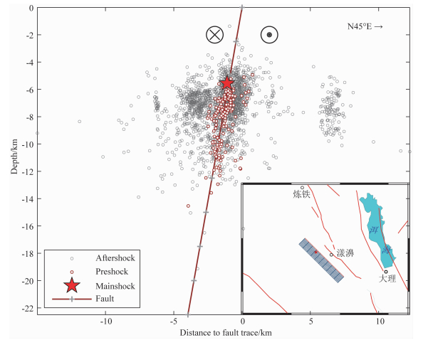
3 断层破裂滑动分布反演由于本次地震并未产生明确的地表破裂,并且前震-主震-余震的空间分布并未与维西—乔后—巍山断裂的地表填图迹线相重合,因此,具体发震断裂的位置和长度尚不明确.为此,我们根据前震主震的精定位结果(Yang et al., 2021)和本文同震位移场的极性特征确定发震断层的走向、倾向和倾角.首先,前震-主震呈线状平行分布在维西—乔后—巍山断裂西南侧,其走向与震源机制解给出的北西向右旋走滑节面一致;其次,前震-主震线状距离维西—乔后—巍山断裂迹线约6~7 km,震源深度集中在4~12 km,纵剖面结果显示地震分布倾向西南,较为陡立.基于这些约束信息,结合同震位移场的空间分区特征,我们认为发震断层沿着前震-主震优势排列方位展布(方位角135°),倾向南西,断层倾角80°(图 5).该断层距离维西—乔后—巍山断裂约5 km.
|
图 5 基于前震精定位结果及本文同震位移场确定的发震断层纵剖面 Fig. 5 The vertical section of seismogenic fault based on the relocated foreshocks and 3D coseismic displacements |
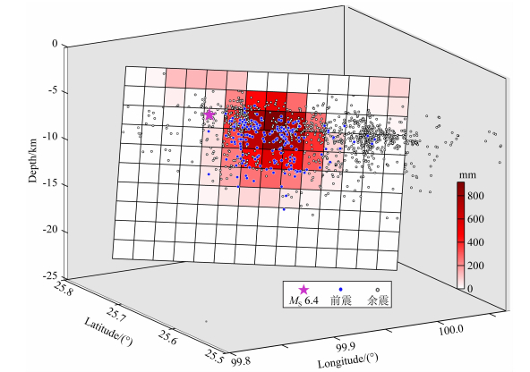
为反演断层面的滑动分布,我们进一步将该断层面沿走向和倾向分割成14×10个2 km×2 km的子断层片.由于涉及区域较小,且缺少深部分层结构、物性参数等资料,本文采用弹性半空间均匀介质断裂位错模型(Okada, 1992).我们采用国内外广泛应用的成熟软件SDM(Wang et al., 2013; 王阅兵等, 2018; Jian et al., 2019)进行断层面滑动分布反演.SDM采用速降梯度迭代算法,对附有应力降分布平滑约束的观测方程进行最小二乘求解.根据拟合残差与断层面滑动分布光滑度之间的折中曲线(王阅兵等, 2018; Jian et al., 2019),我们确定平滑因子为0.11时得到的断层面滑动分布为最佳结果.
最佳反演结果(图 6)显示,滑动量主要集中在3~12 km深度范围内,平均滑动量为236 mm,位于10 km深度以上.主震震源位于最大滑动量的上部边缘.滑动量分布与前震精定位结果具有较好的空间一致性.我们假定泊松比0.25,剪切模量3×10¹⁰Pa,计算得到断层面同震滑动的矩震级为MW6.04,略小于王卫民等(2021)利用地震波反演得到的矩震级MW6.1.
|
图 6 发震断层同震滑动分布 粉色五角星为主震震源位置,蓝色和灰色圆点分别为2级以上前震和余震. Fig. 6 Coseismic slip distribution on the seismogenic fault plane The pink star denotes hypocenter of mainshock, circles in blue and gray represent M≥2 foreshocks and aftershocks, respectively. |
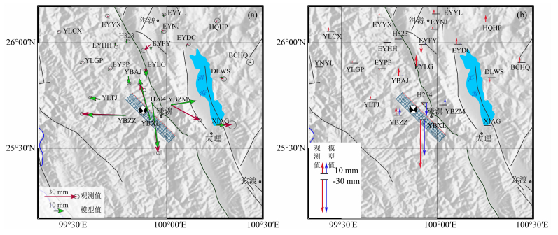
图 7为同震水平位移、垂向位移与模拟结果的对比.近场站点的水平位移拟合程度较高,最近的H204、YBXL和YBZZ残差不超过±5.0 mm.YBZM测站的水平向残差较大,可能与该站所处的位置有关.YBZM站观测标墩建在苍山西镇美翕村一处临崖峭壁顶端的裸露基岩之上,由于观测标墩外侧2 m之外直立悬空,可能在地震时产生“相对较大”的侧向水平位移.这种相对较大的变形是悬崖本身的局部变形,还是与崖下区域可能存在的滑坡体或土质疏松地体有关,有待进一步实地踏勘落实.
|
图 7 同震位移场与模拟结果对比 (a)水平同震位移; (b)垂直同震位移.除YBZM观测站的水平分量拟合残差较大外,模型结果与实际观测值整体取得了很好的吻合.此站残差较大的原因分析见正文. Fig. 7 Comparison between the observed and modeled coseismic displacements (a) Horizontal displacements; (b) Vertical displacements. It can be seen that the model results are in good agreement with the observation values on the whole, except the site YBZM, whose horizontal component has an abnormally large fitting residual. The possible reasons are discussed in the main text. |
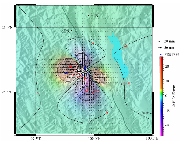
由本文反演的滑动分布推测的地表三维形变场结果(图 8)显示,发震断层南侧区域垂向位移高于北侧,YBXL和YBZZ之间存在由沉降向抬升转换的过渡区.我们在震后实地踏勘时发现,太平乡虾富路一处近东西向的柏油路面(经度99.8685°,纬度25.6642°)因挤压而产生了南北向裂缝,裂缝处的抬升量高达20 cm(图 9).该柏油路面位于两个测站之间的道路上,南侧为水体,北侧为土质疏松的茶园,我们只能看到该段路面被挤压抬升,还没法判断向两侧的延伸是否也发生了挤压抬升.尽管如此,此处柏油路面位于本文预测结果所显示的隆升区域之内,似乎可以作为本文反演结果可靠的有力证据之一.
|
图 8 最佳模型给出的漾濞MS6.4地震三维同震形变场 Fig. 8 Three-dimensional coseismic displacements inferred from the optimal model setting |
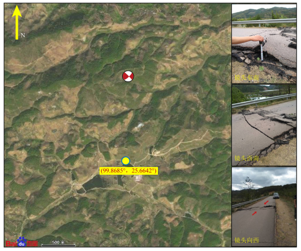
|
图 9 震中附近虾富路某段近东西路面受挤压形成裂缝鼓包 Fig. 9 Fissure on one EW section of Xiafu Road near the epicenter that is resulted from compression due to the coseismic rupture |
云南省地震局发布的《云南漾濞6.4级地震烈度图》(https://www.chuxiong.com/thread-69044-1-1.html)显示,此次地震最高烈度为Ⅷ度,等震线长轴呈北北西走向,地表破坏主要集中在漾濞县苍山西镇、漾江镇、太平乡3个乡镇,东起漾濞县苍山西镇河西村,西至苍山西镇大烂坝,南自苍山西镇沙河村,北达漾江镇弯坡村-桑不老村一带.本文GNSS同震位移场所显示的变形量级及其空间展布与该烈度图基本一致,并展示出更多细节.其中,地表位移最大的4个站都位于VIII度区内:YBXL位于苍山西镇秀岭村,H204位于苍山西镇淮安村,YBZM位于苍山西镇美翕村,YBZZ位于太平乡渣子树村.这4个站的分区变形特征既能给出等震线长轴的方位角,也能大致限定短轴的横向范围.因此,本文GNSS三维同震位移场数据可为地震烈度评估提供准确的基础资料.
本文反演得到断层面滑动量的深度范围与王卫民等(2021)基于地震波资料的反演结果基本一致.然而,我们反演结果的最大滑动量位于主震震源以南区域,与前震序列位置重叠,而王卫民等(2021)的结果则位于震中.这可能反映了不同数据所存在的差异,即地震波形反演的滑动分布主要反映地震P波初动时刻的破裂点位置,而变形场反演结果则反映了地震期间以及震后数天深部弛豫过程所产生的位移之和.此外,本次MS6.4地震之前27 min发生一次MS5.6前震,主震之后1 h内又发生一次MS5.0和一次MS5.3余震。这些前震和余震都有可能在近场产生一定量值的同震变形,但由于它们与主震之间的时间间隔太短,本文利用单日解时间序列获得的同震位移,尚无法将其与主震的同震变形有效分辨出来.因此,本文获得的GNSS同震位移是观测期间所有永久变形的总和,反演得到的断层面滑动分布与地震波反演结果会有所差异,相应的矩震级也稍有不同.
本文基于近场GNSS同震位移场,反演得到的断层滑动分布的初步结果,在以下两方面还有很大改进空间:首先是测站的有效覆盖空间密度不足,无法给出准确的断层面滑动分布结果.本次地震位于GNSS台阵的最南端,地震所产生的同震变形集中在震中附近,因而,只有震中距较近的部分观测站记录到可靠的同震变形信号.用少量观测值去反演多于观测量的精细断层面滑动,本身是一个欠定问题,具有多解性.尽管反演中采用了平滑约束,但并未从根源上解决滑动分布空间分辨率不足的问题.其次是本文采用的断层模型可能与真实发震断层还有较大差距.由于该区域深部结构的探测和研究程度较低,目前还没有断层三维展布的相关资料,我们根据前震序列和已有构造对发震断层进行推测,将断层面设置为单一走向和单一倾角,模型相对简单,而实际地震的发震断层可能还存在走向转折、倾角变化甚至空间断续等复杂几何结构.
总之,基于高精度、高密度的“大理连续GNSS观测台阵”,我们获得了漾濞MS6.4强震的可靠三维同震形变场,并以此为约束,反演推测了断层破裂面的滑动分布,但仅仅基于此GNSS观测资料的约束,我们的滑动分布结果尚比较初步.下一步我们期待与业界同行一道,将GNSS三维同震位移资料与地震精定位结果、InSAR观测资料和地震波形等多学科资料综合在一起,开展更加精细的研究探索,给出更科学、合理的解释,以加深对本次地震的发震断裂、发震机理的认识,为该地为区域地震危险性评价提供更可靠的断层模型.
致谢 我们感谢云南省地震局邵德胜、杨军两位高级工程师在GNSS台阵布设过程中给予了大力支持.感谢中国地震台网中心提供了部分“中国大陆构造环境监测网络”基准站资料.感谢中国地震局地震研究所/湖北省地震局陈正松博士在GNSS台阵运维和通讯技术方面提供了指导和培训.感谢德国GFZ汪荣江教授提供了SDM反演软件并在使用中给予了细心指导.感谢两位匿名审稿专家对本文的修改和完善提出了宝贵的意见.文中大部分图件使用GMT软件(Wessel and Smith, 1995)绘制.
Allen C R, Gillespie A R, Yuan H, et al. 1984. Red River and associated faults, Yunnan Province, China: Quaternary geology, slip rates, and seismic hazard. GSA Bulletin, 95(6): 686-700. DOI:10.1130/0016-7606(1984)95〈686:RRAAFY〉2.0.CO;2 |
Altamimi Z, Métivier L, Rebischung P, et al. 2017. ITRF2014 plate motion model. Geophysical Journal International, 209(3): 1906-1912. DOI:10.1093/gji/ggx136 |
Bertiger W, Desai S D, Haines B, et al. 2006. Single receiver phase ambiguity resolution with GPS data. Journal of Geodesy, 84(5): 327-337. |
Boehm J, Niell A, Tregoning P., et al. 2006. Global Mapping Function (GMF): A new empirical mapping function based on numerical weather model data. Geophysical Research Letters, 33(L07304): 1-4. DOI:10.1029/2005GL025546 |
Chang Z F, Chang H, Zang Y, et al. 2016. Recent active features of Weixi-Qiaohou fault and its relationship with the Honghe fault. Journal of Geomechanics (in Chinese), 22(3): 517-530. |
Chang Z F, Zhang Y F, Zhou Q Y, et al. 2014. Intensity distribution characteristics and active tectonic background in area of the 2013 Eryuan MS5.5 earthquake.. Earthquake Research in China (in Chinese), 30(4): 560-570. |
Cheng J, Liu J, Gan W J, et al. 2011. Characteristics of strong earthquake evolution around the eastern boundary faults of the Sichuan-Yunnan rhombic block. Science China Earth Science, 54(11): 1716-1729. DOI:10.1007/s11430-011-4290-2 |
Cheng J, Xu X W, Gan W J, et al. 2012. Block model and dynamic implication from the earthquake activities and crustal motion in the southeastern margin of Tibetan Plateau. Chinese Journal of Geophysics (in Chinese), 55(4): 1198-1212. DOI:10.6038/j.issn.0001-5733.2012.04.016 |
Dong D N, Fang P, Bock Y, et al. 2006. Spatiotemporal filtering using principal component analysis and Karhunen-Loeve expansion approaches for regional GPS network analysis. Journal of Geophysical Research Solid Earth, 111(B3): B03405. DOI:10.1029/2005jb003806 |
Gan W J, Zhang P Z, Shen Z K, et al. 2007. Present-day crustal motion within the Tibetan Plateau inferred from GPS measurements. Journal of Geophysical Research: Solid Earth, 112(B8): B08416. DOI:10.1029/2005JB004120 |
Guo S M, Ji F J, Xiang H F, et al. 2013. Geological Map of the Red River Fault in Yunnan Province, China (in Chinese). Beijing: Seismological Press: 1-21.
|
Guo S M, Zhang J, Li X G, et al. 1984. Fault displacement and recurrence intervals of earthquakes at the northern segment of the Honghe fault zone, Yunnan province. Seismology and Geology (in Chinese), 6(1): 1-12. |
Huang X L, Wu Z H, Jiang Y, et al. 2015. Seismic intensity distribution and seismogenic structure analysis of the March 3, 2013 Eryuan MS5.5 earthquake in Dali, Yunnan Province. . Geological Bulletin of China (in Chinese), 34(1): 135-145. |
Jian H Z, Wang L F, Gan W J, et al. 2019. Geodetic Model of the 2017 MW6.5 Mainling Earthquake Inferred from GPS and InSAR Data.. Remote Sensing, 11(24): 2940. DOI:10.3390/rs11242940 |
Leloup P H, Lacassin R, Tapponnier P, et al. 1995. The Ailao Shan-Red River shear zone (Yunnan, China), tertiary transform boundary of Indo-China. Tectonophysics, 251(1-4): 3-10, 13-84. DOI:10.1016/0040-1951(95)00070-4 |
Li X, Ran Y K, Chen L C, et al. 2016. The Holocene seismic evidence on southern segment of the Red River fault zone. Seismology and Geology (in Chinese), 38(3): 596-604. |
Li Z J, Wang Y, Gan W J, et al. 2020. Diffuse deformation in the se tibetan plateau: new insights from geodetic observations. Journal of Geophysical Research: Solid Earth, 125(10): e2020JB019383. DOI:10.1029/2020JB019383 |
Ma J, Guo Y S. Accelerated synergism prior to fault instability: evidence from laboratory experiments and an earthquake case. Seismology and Geology (in Chinese), 36(3): 547-551.
|
Ma J, Sherman S I, Guo Y S. 2012. Identification of meta-instable stress based on experimental study of evolution of the temperature field during stick-slip instability on a 5° bending fault. Science China: Earth Science (in Chinese), 42(5): 633-645. DOI:10.1007/s11430-012-4423-2 |
Okada Y. 1992. Internal deformation due to shear and tensile faults in a half-space. Bulletin of the Seismological Society of America, 82(2): 1018-1040. |
Pan R, Jiang J Z, Fu H, et al. 2019. Focal mechanism and focal depth determination of Yunnan Yangbi MS5.1 and MS4.8 earthquakes in 2017.. Journal Seismological Research (in Chinese), 42(3): 338-348. |
Ren J J, Zhang S M, Hou Z H, et al. 2007. Study of late quaternary slip rate in the mid-segment of the Tongdian-Weishan fault. Seismology and Geology (in Chinese), 29(4): 756-764. |
Replumaz A, Lacassin R, Tapponnier P, et al. 2001. Large river offsets and Plio-Quaternary dextral slip rate on the Red River fault (Yunnan, China). Journal of Geophysical Research: Solid Earth, 106(B1): 819-836. DOI:10.1029/2000JB900135 |
Schmid R, Steigenberger P, Gendt G, et al. 2007. Generation of a consistent absolute phase-center correction model for GPS receiver and satellite antenna. Journal of Geodesy, 81: 781-798. DOI:10.1007/s00190-007-0148-y |
Schoenbohm L M, Burchfiel B, Chen L Z, et al. 2006. Miocene to present activity along the red river fault, china, in the context of continental extrusion, upper-crustal rotation, and lower-crustal flow. GSA Bulletin, 118(5-6): 672-688. DOI:10.1130/B25816.1 |
Shen Z K, Lü J, Wang M, et al. 2005. Contemporary crustal deformation around the southeast borderland of the Tibetan Plateau. Journal of Geophysical Research: Solid Earth, 110(B11): B11409. DOI:10.1029/2004JB003421 |
Shi X H, Sieh K, Weldon R, et al. 2018. Slip rate and rare large prehistoric earthquakes of the Red River fault, southwestern China. Geochemistry, Geophysics, Geosystems, 19(7): 2014-2031. DOI:10.1029/2017GC007420 |
Wang E Q, Burchfiel B C, Royden L H, et al. 1998. Late Cenozoic Xianshuihe-Xiaojiang, Red river, and Dali fault systems of southwestern Sichuan and central Yunnan, China. Geological Society of America Special Paper, 327: 1-108. DOI:10.1130/0-8137-2327-2.1.Boulder,Colorado:GeologicalSocietyofAmerica |
Wang M, Shen Z K. 2020. Present-day crustal deformation of continental china derived from GPS and its tectonic implications. Journal of Geophysical Research: Solid Earth, 125(2): e2019JB018774. DOI:10.1029/2019JB018774 |
Wang R J, Diao F Q, Hoechner A. 2013. SDM-A geodetic inversion code incorporating with layered crust structure and curved fault geometry. //Proceedings of the General Assembly European Geosciences Union. Vienna, Austria: EGU.. |
Wang W M, He J K, Hao J L, et al. 2021. Preliminary result for rupture process of May 21, 2021, M6.4 earthquake, Dali, China.. Personal Communication (in Chinese). |
Wang W, Qiao X J, Yang S M, et al. 2017. Present-day velocity field and block kinematics of Tibetan plateau from GPS measurements. Geophysical Journal International, 208(2): 1088-1102. DOI:10.1093/gji/ggw445 |
Wang Y B, Gan W J, Chen W T, et al. 2018. Coseismic displacements of the 2017 Jiuzhaigou M7.0 earthquake observed by GNSS: preliminary results.. Chinese Journal of Geophysics (in Chinese), 61(1): 161-170. DOI:10.6038/cjg2018L0611 |
Wang Y Z, Wang E N, Shen Z K, et al. 2008. GPS-constrained inversion of present-day slip rates along major faults of the Sichuan-Yunnan region, China. Science in China Series D: Earth Sciences, 51(9): 1267-1287. DOI:10.1007/s11430-008-0106-4 |
Webb F H, Zumberge J F. 1993. An introduce to GIPSY-OASIS II, Jet Propulsion Laboratory user manual, JPL Technical Document D-11088, Jet Propulsion Lab, Pasadena, California.
|
Wen X Z, Du F, Long F, et al. 2011. Tectonic dynamics and correlation of major earthquake sequences of the Xiaojiang and Qujiang-Shiping fault systems, Yunnan, China. Science China Earth Sciences, 54(10): 1563-1575. DOI:10.1007/s11430-011-4231-0 |
Wen X Z, Ma S L, Xu X W, et al. 2008. Historical pattern and behavior of earthquake ruptures along the eastern boundary of the Sichuan-Yunnan faulted-block, southwestern China. Physics of the Earth and Planetary Interiors, 168(1-2): 16-36. DOI:10.1016/j.pepi.2008.04.013 |
Wessel P, Smith W H F. 1995. New version of the Generic Mapping Tools released, EOS Trans. AGU, 76, p.329.
|
Xu J, Shao Z G, Liu J, et al. 2019. Coulomb stress evolution and future earthquake probability along the eastern boundary of the Sichuan-Yunnan block. Chinese Journal of Geophysics (in Chinese), 62(11): 4189-4213. DOI:10.6038/cjg2019M0593 |
Yang J, Su Y J, Li X B, et al. 2015. Research on focal mechanism solutions of ML > 3.4 earthquakes of Eryuan MS5.5 earthquake sequence in 2013.. Journal of Seismological Research (in Chinese), 38(2): 196-202. |
Yang T, Zhong Y S, Fang L H, et al. 2021. Relocation of the aftershock sequence of the MS6.4 Yangbi earthquake, Yunnan. Journal of Earth Science, in review. https://www.researchgate.net/publication/352160417_Relocation_of_the_aftershock_sequence_of_the_MS64_Yangbi_earthquake_Yunnan?channel=doi & linkId=60bc123d92851cb13d7ec5a6 & showFulltext=true.
|
Yin F L, Jiang C S, Han L B, et al. 2018. Seismic hazard assessment for the Red River fault: insight from Coulomb stress evolution. Chinese Journal of Geophysics (in Chinese), 61(1): 183-198. DOI:10.6038/cjg2018L0369 |
Zhang P Z, Shen Z K, Wang M, et al. 2004. Continuous deformation of the Tibetan Plateau from global positioning system data. Geology, 32(9): 809-812. DOI:10.1130/G20554.1 |
Zhang P Z. 2013. Beware of slowly slipping faults. Nature Geoscience, 6(5): 323-324. DOI:10.1038/ngeo1811 |
Zhao X Y, Fu H. 2014. Seismogenic structure identification of the 2013 Eryuan MS5.5 and MS5.0 earthquake sequence.. Acta Seismologica Sinica (in Chinese), 36(4): 640-650. DOI:10.3969/j.issn.0253-3782.2014.04.010 |
Zumberge J F, Heflin M B, Jefferson D C, et al. 1997. Precise point positioning for the efficient and robust analysis of GPS data from large networks. Journal of Geophysical Research: Solid Earth, 102(B3): 5005-5017. DOI:10.1029/96JB03860 |
常祖峰, 张艳凤, 周青云, 等. 2014. 2013年洱源MS5.5地震烈度分布及震区活动构造背景研究.. 中国地震, 30(4): 560-570. |
常祖峰, 常昊, 臧阳, 等. 2016. 维西—乔后断裂新活动特征及其与红河断裂的关系. 地质力学学报, 22(3): 517-530. DOI:10.3969/j.issn.1006-6616.2016.03.009 |
程佳, 刘杰, 甘卫军, 等. 2011. 川滇菱形块体东边界各断层段强震演化特征研究. 中国科学地球科学, 41(9): 1131-1326. |
程佳, 徐锡伟, 甘卫军, 等. 2012. 青藏高原东南缘地震活动与地壳运动所反映的块体特征及其动力来源. 地球物理学报, 55(4): 1198-1212. DOI:10.6038/j.issn.0001-5733.2012.04.016 |
虢顺民, 张靖, 李祥根, 等. 1984. 云南红河断裂带北段断裂位错与地震重复发生的时间间隔. 地震地质, 6(1): 1-12. |
虢顺民, 计凤桔, 向红发, 等. 2013. 云南红河断裂带地质图: 1:50000. 北京: 地震出版社: 1-21.
|
黄小龙, 吴中海, 蒋瑶, 等. 2015. 2013年3月3日云南大理洱源MS5.5地震烈度分布及发震构造.. 地质通报, 34(1): 135-145. |
李西, 冉勇康, 陈立春, 等. 2016. 红河断裂带南段全新世地震活动证据. 地震地质, 38(3): 596-604. DOI:10.3969/j.issn.0253-4967.2016.03.007 |
马瑾, 郭彦双. 2014. 失稳前断层加速协同化的实验室证据和地震实例. 地震地质, 36(3): 547-551. DOI:10.3969/j.issn.0253-4967.2014.03.001 |
马瑾, Sherman S I, 郭彦双. 2012. 地震前亚失稳应力状态的识别—以5°拐折断层变形温度场演化的实验为例. 中国科学:地球科学, 42(5): 633-645. |
潘睿, 姜金钟, 付虹, 等. 2019. 2017年云南漾濞MS5.1及MS4.8地震震源机制解和震源深度测定.. 地震研究, 42(3): 338-348. |
任俊杰, 张世民, 侯治华, 等. 2007. 滇西北通甸—巍山断裂中段的晚第四纪滑动速率. 地震地质, 29(4): 756-764. DOI:10.3969/j.issn.0253-4967.2007.04.006 |
王卫民, 何建坤, 郝金来, 等. 2021. 2021年5月21日云南大理M6.4级地震震源破裂过程反演初步结果.. 个人通讯.. |
王阎昭, 王恩宁, 沈正康, 等. 2008. 基于GPS资料约束反演川滇地区主要断裂现今活动速率. 中国科学D辑:地球科学, 38(5): 582-597. DOI:10.3321/j.issn:1006-9267.2008.05.006 |
王阅兵, 甘卫军, 陈为涛, 等. 2018. GNSS观测的九寨沟7.0级地震同震位移初步结果.. 地球物理学报, 61(1): 161-170. |
闻学泽, 杜方, 龙锋, 等. 2011. 小江和曲江—石屏两断裂系统的构造动力学与强震序列的关联性. 中国科学:地球科学, 41(5): 713-724. |
徐晶, 邵志刚, 刘静, 等. 2019. 川滇菱形块体东边界库仑应力演化及强震发生概率估算. 地球物理学报, 62(11): 4189-4213. DOI:10.6038/cjg2019M0593 |
杨军, 苏有锦, 李孝宾, 等. 2015. 2013年洱源MS5.5地震序列ML≥3.4地震的震源机制解研究.. 地震研究, 38(2): 196-202. |
尹凤玲, 蒋长胜, 韩立波, 等. 2018. 红河断裂带库仑应力演化及未来地震危险性估计. 地球物理学报, 61(1): 183-198. |
赵小艳, 付虹. 2014. 2013年洱源MS5.5和MS5.0地震发震构造识别.. 地震学报, 36(4): 640-650. |
 2021, Vol. 64


