2. 中国地震局地质研究所 西藏拉萨地球物理野外观测站, 拉萨 850004;
3. 四川省地震局 中国地震局成都青藏高原地震研究所, 成都 610041;
4. 中国地震局第二监测中心, 西安 710043;
5. 陕西省地震局, 西安 710068;
6. 中山大学 地球科学与工程学院, 广州 510275
2. Lhasa National Geophysical Observation and Research Station, Institute of Geology, China Earthquake Administration, Lhasa 850004, China;
3. Earthquake Administration of Sichuan Province, Chengdu 610041, China;
4. The Second Monitoring and Application Center, China Earthquake Administration, Xi'an 710043, China;
5. Earthquake Administration of Shaanxi Province, Xi'an 710068, China;
6. School of Earth Sciences and Engineering, Sun Yat-Sen University, Guangzhou 510275, China
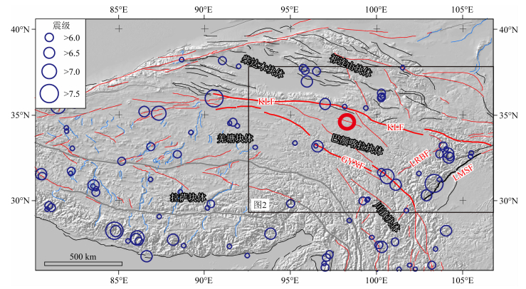
据中国地震台网正式测定,2021年5月22日2时4分在青海省果洛藏族自治州玛多县发生MS7.4地震,震源深度17 km,震中位于34.59°N,98.34°E(图 1),中国地震台网测定的快报目录显示,截至2021年5月27日,玛多地震余震序列共记录到ML0以上地震2700多次,其中ML3.0~3.9地震521次,ML4.0~4.9地震99次,ML5.0~5.9地震11次,ML7.0以上地震1次,无ML6.0~6.9地震.据中国地震台网中心统计,近10年来,震中所在的果洛藏族自治州共发生3级以上地震7次,其中3.0~3.9级4次,4.0~4.9级2次,5.0~5.9级1次,最大地震是2015年10月12日在青海省果洛藏族自治州玛多县发生的5.2级地震.近20年来,巴颜喀拉块体边界发生了一系列强震,如2001年昆仑山口8.1级地震、2008年汶川8.0级地震、2011年玉树7.1级地震、2013年芦山7.0级地震、2017年九寨沟7.0级地震(图 1),特别是沿北边界东昆仑断裂带东段,是中国大陆中强地震发生最为密集的地方,自1960年以来,在该区就发生过4次6级以上中强地震,如1960年漳腊地震、1973年黄龙地震和1976年松潘地震群(图 1;Jones et al., 1984;王光弟,1988;Chen et al., 1994;朱航和闻学泽,2009).
|
图 1 青藏高原主要活动断裂及历史地震分布 图中断裂据Taylor and Yin (2009);红色为走滑断裂,黑色为逆断裂,蓝色为正断层,灰色为缝合带;红色圆圈为2021.5.22日玛多地震震中位置;KLF,东昆仑断裂带;GYXF,甘孜—玉树—鲜水河断裂带;LMSF,龙门山断裂带;LRBF,龙日坝断裂. Fig. 1 Distribution of major active faults in the Tibetan Plateau and historical earthquakes The faults are from Taylor and Yin (2009); Red lines denote slip fault; Black lines denote reverse fault; Blue lines denote normal fault; Gray lines denote suture zone; Red circle is the epicenter of 2021.5.22 Madoi earthquake; Abbreciations are: KLF, East Kunlun fault; GYXF, Garzê-Yushu-Xianshuihe fault; LMSF, Longmenshan fault zone; LRBF, Longriba fault. |
综合来看,近些年来巴颜喀拉块体边界断裂带上发生的中强地震研究程度相对较高,然而有关沿块体内部断裂的历史地震、古地震及活动速率等仍鲜有报道(熊仁伟等,2010;梁明剑等, 2014, 2020).梁明剑等(2014, 2020)曾重点对达日断裂开展野外调查及详细地构造地貌研究,并厘清了1947年达日7.7级地震的同震地表破裂带.熊仁伟等(2010)曾重点调查过玛多—甘德断裂甘德段的晚第四纪活动性,发现断裂长期具有左旋走滑特征.2021年5月22日发生的玛多MS7.4地震震中也位于巴颜喀拉块体内部,距离块体北边界东昆仑断裂带以南约70 km,鉴于为认识和理解本次强震的发震机制,为后续地震趋势研判提供基础资料,亟需在确定发震断裂的基础上,对其深部构造环境及孕震模式开展研究.
自印度—欧亚板块新生代碰撞以来,青藏高原及其周缘山地不断隆升,构造变形及应力传递对整个东亚地区的构造也都带来了深远的影响(Yin and Harrison, 2000).其中青藏高原北缘巴颜喀拉块体和周缘地区构造变形强烈,除其边界断裂的持续变形外,在其内部也产生了复杂的断裂系统,不同断裂之间的应变分配也关系到我们如何认识青藏高原演化(图 2;Tapponnier and Molnar, 1977; Tapponnier et al., 1982; Avouac and Tapponnier 1993; Houseman and England 1993;Mériaux et al., 2004; Cowgill et al., 2009; Gold et al., 2009, 2011; Kirby and Harkins 2013; Chu et al., 2019).断裂带的持续变形及不断活动,为流体的赋存和运移创造了必要空间和条件,并会导致断层的活动性变化,断裂带不同分段相互连通也可以引起断裂带内部岩体电导率值大幅度增加(Bürgmann,2018).由于大地电磁方法能够灵敏地观测岩体电导率的变化,因此常用于活动断裂结构探测研究(Unsworth and Bedrosian, 2004;Becken et al., 2011).近十多年来,青藏高原东缘发生了如汶川、芦山、九寨沟等一系列中强地震,在龙门山构造带、阿尔金断裂带、海原—六盘山断裂带不同段落上开展的大地电磁探测研究,揭示出沿活动断裂不同段落的深部电阻率结构差异及一系列强震、大震的深部构造环境,表明中强地震及余震分布主要受到地下介质电阻率结构的控制(Zhao et al., 2012;Zhan et al., 2013;Wang et al., 2014;Xiao et al., 2017;詹艳等,2017;赵凌强等, 2015, 2019;Cai et al., 2017;Sun et al., 2019, 2020).

|
图 2 巴颜喀拉块体中东部断裂分布及形变场 图中GPS数据引自Wang and Shen (2020);沿东昆仑玛曲附近及龙门山次级块体内已有测线及编号标示图中,详细剖面信息见图 9;KLF,东昆仑断裂带;GYXF,甘孜—玉树—鲜水河断裂带;LMSF,龙门山断裂带;LRBF,龙日坝断裂;MG,玛多—甘德断裂;D,达日断裂;W,五道梁—长沙贡玛断裂;M,岷江断裂;H,虎牙断裂. Fig. 2 Distribution of active faults and deformation pattern of the Bayan Har Block The GPS data are from Wang and Shen (2020); Profiles across the Maqu section of East Kunlun fault and Longmenshan sub-block are showed in this figure. More detail of these profile are showed in Fig. 9. Abbreciations are: KLF, East Kunlun fault; GYXF, Garzê-Yushu-Xianshuihe fault; LMSF, Longmenshan fault zone; LRBF, Longriba fault; MG, Madoi-Gadê fault; D, Dari fault; W, Wudaoliang-Changshagongma fault; M, Minjiang fault; H, Huya fault. |
为了探查青藏高原北部的活动断裂带及其深部结构,在2014年中国地震局喜马拉雅台阵项目资助下,团队成员曾沿玛多—阿拉善右旗大剖面开展了宽频带大地电磁探测,2021年5月22日发生的玛多MS7.4地震震中正好位于该剖面的西南段附近(图 3).地震发生后,我们通过震中位置、余震分布、卫星影像解译及活动断裂分布等基础资料,首先对发震断裂进行了判定,后续分析反演了玛多震中区附近长约280 km的大地电磁剖面数据(图 3),获取玛多MS7.4地震区深部电性结构特征,用于分析和认识玛多地震及东昆仑中东段孕震区的深部构造背景;同时与巴颜喀拉块体东北边界多个震区的6条大地电磁剖面测深结果进行了对比分析(剖面位置见图 2),以厘清东昆仑断裂带中东段的应变分配模式.综合地质、地貌以及深部结构资料,探讨了玛多MS7.4地震的发震构造模式以及巴颜喀拉块体构造变形的动力学机制.

|
图 3 玛多地震及邻区大地电磁实测点位和玛多余震分布(ML≥4.0) Fig. 3 Locations of MT stations, and aftershocks (ML≥4.0) of Madoi earthquake |
中国大陆内部主要划分为6个一级活动块体,而青藏高原活动块体,又可分为一系列二级活动块体(张培震等,2003),其中巴颜喀拉块体是青藏高原新生代以来侧向挤出具代表性的活动块体之一,被以东昆仑断裂带为北边界、甘孜—玉树—鲜水河断裂带为南边界、龙门山断裂带为东边界和阿尔金断裂带为西边界所围限的广大区域,是现今我国强震、大地震活动最为强烈的地区之一(图 1;Tapponnier et al.,1982;张培震等,2003;Zhang et al.,2004;Burchfiel et al.,2008;Xu and Stamps, 2016;闻学泽,2018).近20年来,巴颜喀拉块体周缘正处于中强地震活跃期,成为中国大陆地震活动主体(图 1;邓起东等,2010),尤其块体东缘相继发生2008年汶川8.0级地震、2013年芦山7.0级地震和2017年九寨沟7.0级地震,表明地震应变能在近一百多年以来处于加速释放的态势(闻学泽,2018).
巴颜喀拉块体北边界东昆仑断裂是一条巨型左旋走滑断裂带(图 2),总体走向近EW向,绵延近2000 km,倾角55~85°,总体向北(青海省地震局等,1999;Van der Woerd et al., 2002).在东昆仑断裂西段,沿断裂的左旋走滑速率约为10 mm·a-1(Van der Woerd et al., 2002),自西向东滑动速率快速减小,在玛沁段大约为12.5 mm·a-1,向东至玛曲段约为5 mm·a-1,到塔藏段迅速衰减到3 mm·a-1以下(Kirby et al., 2007;Li et al., 2011;Ren et al., 2013).据历史记载,在东昆仑断裂带中西段曾发生过5次MS7.0~7.9地震和1次MS8.1地震(国家地震局震害防御司,1995;汪素云,1999;青海省地震局,1999;邓起东等, 2002, 2003;徐锡伟等,2002),地表仍保留不同规模的同震破裂带,其中2001年昆仑山口西MS8.1地震地表破裂带长约426 km(Xu et al., 2002, 2006).
巴颜喀拉块体南边界为甘孜—玉树—鲜水河断裂带(图 2),晚第四纪以来及现今构造活动异常强烈,以左旋走滑为特征,向南与安宁河—小江断裂带相连,控制了有历史记载以来17次7级以上地震的发生.甘孜—玉树断裂带与鲜水河断裂呈左阶羽列,晚第四纪以来甘孜—玉树断裂水平滑动速率的研究工作主要集中在中南段,地质上获得水平速率一般在5~8 mm·a-1(周荣军等, 1996, 1997;彭华等,2006;Chevalier et al.,2017),也有学者获得的水平速率相对较高,达8~14 mm·a-1(闻学泽等,2003;石峰等,2013).
鲜水河断裂作为巴颜喀拉块体和川滇菱形块体之间的左旋走滑边界断裂(图 1),强震、大地震活动很活跃,自1700年有地震记载以来,共发生了8次7级以上的强震,地震地表破裂几乎覆盖了整条断裂.而且,鲜水河断裂一直被认为是高滑动速率的左旋走滑断裂,水平滑动速率达(10±2)~(13±5) mm·a-1(钱洪, 1988;Allen et al., 1991;唐荣昌和韩渭宾, 1993;Zhang, 2013;Chen et al., 2016).
2 巴颜喀拉块体内部断裂体系除了边界断裂外,巴颜喀拉块体内部东部地区还发育着一系列大型的活动断裂(图 2).NE走向的龙日坝断裂为一条全新世活动的断裂,将巴颜喀拉块体分割为阿坝次级块体(西北部)和龙门山次级块体(东南部)(Shen et al.,2005;徐锡伟等,2008;Ren et al.,2013;陈长云等,2013),被认为是巴颜喀拉块体SE向运移过程中由于受到华南块体的强烈阻挡而形成的龙门山构造带的后展式推覆构造系统(徐锡伟等,2008).
阿坝次级块体内还发育着一系列北西向走滑断裂,包括阿万仓断裂、玛多—甘德断裂、达日断裂和五道梁—长沙贡玛断裂等(图 2),晚第四纪活动性特征明显(戴华光,1983;叶世强和张启富,1993;青海省地震局,1984;熊仁伟等,2010;Yan et al.,2013;李陈侠等,2016;梁明剑等, 2014, 2020;刘雷等,2021).其中,阿万仓断裂为全新世活动的左旋走滑断裂,晚第四纪平均滑动速率为~3.0 mm·a-1,构成了东昆仑断裂东段活动速率分配的重要分支断裂(李陈侠等,2016).玛多—甘德断裂也是全新世活动的左旋走滑断裂,在缺乏年代学样品情况下,熊仁伟等(2010)依据区域地貌面对比,认为甘德段晚更新世以来水平滑动速率 < 6~8 mm·a-1.达日断裂也为全新世活动断裂(戴华光,1983),断裂中段仍保留有1947年达日7.7级地震长约70 km的地表破裂带(梁明剑等,2020),而断裂晚第四纪以来的平均水平滑动速率至今没有报道.五道梁—长沙贡玛断裂的研究比较薄弱,笔者之一(梁明剑)最新的野外调查结果表明,该断裂也具有明显的晚第四纪活动性,左旋滑动速率与其他断裂基本相当.总体而言,阿坝次级块体内各断裂体系向东南主体终止于龙日坝断裂带附近,零星的断裂走滑速率结果表明,上述断裂系的活动速率要明显小于南边界甘孜—玉树—鲜水河断裂带和北边界东昆仑断裂带的(图 2).
龙门山次级块体内,主要包括龙门山构造带内的三条断裂带(茂县—汶川断裂、映秀—北川断裂和江油—灌县断裂)、岷江断裂、虎牙断裂等次级断裂(图 2).利用地貌断错和年代测定,整个龙门山构造带内断裂带晚第四纪右旋累积滑动速率为2~3 mm·a-1(唐荣昌和韩渭宾, 1993).Densemore等(2007)沿映秀—北川断裂获得的全新世水平滑动速率约为0.5 mm·a-1,江油—灌县断裂的滑动速率约为0.6 mm·a-1.跨龙门山断裂带十年时间尺度的GPS观测也显示现今构造变形速度不超过2 mm·a-1(张培震等,2008).
岷江断裂也是一条全新世活动断裂(图 2;赵小麟等,1994;周荣军等,2000),全长约170 km,位于岷山隆起西侧,北起弓嘎岭以北,南至茂县以北,走向呈近SN,断面W倾,倾角不定,在松潘以北有良好的出露,表现为具明显挤压特征,是破碎带宽达百米的羽列断裂带(钱洪等,1995),晚第四纪活动性表现为全新世洪积扇的断错、晚更新世晚期湖相沉积层的变形、断错冲沟以及全新世断塞塘等,岷江断裂晚第四纪以来的平均垂直滑动速率为0.37~0.53 mm·a-1.水平滑动速率约为1 mm·a-1(李勇等,2005;赵小麟等,1994).虎牙断裂位于岷山隆起东侧(图 2),地表断裂长~60 km,总体走向为北北西向,晚第四纪以来的平均水平滑动速率为1.4 mm·a-1左右,垂直滑动速率为0.3 mm·a-1左右(李勇等,2005;赵小麟等,1994),从一系列的中强震沿断裂带总体方向呈北西向条带分布,特别是2017年九寨沟MS7.0地震及其余震分布来看,该断裂北西段属一条新生的隐伏断裂,由北西侧的走滑向南逐渐转变为逆冲,主体控制着岷山的快速隆起(Sun et al., 2020).
3 玛多MS7.4地震发震构造:玛多—甘德断裂如前所述,巴颜喀拉块体内部虽然发育有一系列规模不等的走滑断裂系(图 2),由于历史地震记载资料不全,另外高原内部地震地质调查难度大,到目前为止有关块体内部断裂的历史地震、古地震及活动速率等研究程度参差不齐(熊仁伟等,2010;梁明剑等, 2014, 2020),特别是有关巴颜喀拉块体内部中强地震的发震构造,仅有的报道仍存在分歧.例如,2001年昆仑山口西MS8.1地震发生之前,巴颜喀拉块体内部青海省境内震级最大的一次地震为1947年达日7.7级地震(刘雷等,2021).戴华光等(1983)认为达日地震的地表破裂带长达150 km,发震断裂为达日南部地区日查—克授滩断裂;青海省地震局(1984)则认为达日地震地表破裂带全长仅58 km左右;梁明剑等(2020)通过野外详细调查及影像解译,确定1947年地震的地表破裂带全长约70 km,同震位错为2~4m,主要表现为地震陡坎、地震鼓包与陷坑、草皮撕裂带、线性的碎裂基岩出露等.
除达日断裂外,玛多—甘德断裂也是巴颜喀拉块体内部全新世活动的左旋走滑断裂(图 2),全长约650 km,在遥感图像上该断裂呈现出明显的线性特征,沿断裂分布发育有一系列谷地,在玛多以西走向近东西向,进入玛多盆地北缘逐渐转为北西向,经甘德、班玛向东南与阿坝断裂体系相接(熊仁伟等,2010).熊仁伟等(2010)重点调查了玛多—甘德断裂甘德段,发现个别地表破裂带上保留有多期地震活动的痕迹,最新活动切割了一系列全新世冲沟及洪积扇,断裂长期活动导致冲沟水系、山脊等地质体都存在不同时代和规模的水平错动,如冲沟被左旋水平断错几米到几十米不等,断裂带通过处的多条黄河支流也被同步左旋错动,位错量在300~850 m之间,显示出断裂活动长期具有强烈的左旋走滑特征.
玛多MS7.4地震发生后,我们参考国家地震活断层研究中心活动断裂数据(http://www.neotectonics.cn/arcgis/apps/webappviewer/index.html?id=3c0d8234c1dc43eaa0bec3ea03bb00bc),依据中国地震台网中心发布的震中位置(34.59°N,98.34°E),初步判断玛多地震的发震断裂为玛多—甘德断裂(图 4).截止5月27日,发生了ML3.0以上地震632次,其中ML4.0以上地震111次,玛多地震余震的空间分布长度达170 km(图 3,图 4).据野外现场的初步调查结果显示,本次地震沿玛多—甘德断裂形成的地表破裂近NWW-SEE向延伸,破裂长约70 km(https://mp.weixin.qq.com/s/Knp_IjCNS9JmvS8tR76gqg).采用国际通用高精密数据处理软件对野外应急流动观测数据进行计算,分析结果表明,在距离地表破裂东西两侧较近处各有一个GNSS测站记录到超过1 m的同震水平向偏移(https://mp.weixin.qq.com/s/4Lv9-ku7G92GaqxeYMDZgw).

|
图 4 玛多地震及邻区活动断层遥感卫星影像解译 五角星为震中位置,蓝色白框圆圈为4级以上余震.遥感卫星数据为Landsat 7 ETM+影像,空间分辨率为~15 m,来源https://landsat.gsfc.nasa.gov/landsat-7/landsat-7-etm. Fig. 4 Interpretation of the active faults from Landsat image around the Madoi earthquake The yellow star is the epicenter of Maduo earthquake; Blue circles denote aftershocks (M > 4); Remote sensing satellite data from Landsat 7 ETM+ image with spatial resolution of ~15 m (https://landsat.gsfc.nasa.gov/landsat-7/landsat-7-etm). |
考虑到玛多—甘德断裂甘德段长期具有强烈的左旋走滑运动特征(熊仁伟等,2010),我们利用Landsat 7 ETM+卫星影像解译进行了初步解译(图 4),通过明显的线性影像特征,结合余震的空间分布,初步确定东昆仑断裂带南部约70 km的巴颜喀拉块体内部的玛多—甘德断裂为本次地震的发震断裂.在此基础上,我们重点分析反演了玛多震中区附近长约280 km的大地电磁剖面数据(图 3),以期探讨和理解玛多MS7.4地震深部构造环境和孕震构造模式.
4 大地电磁数据采集、处理和反演 4.1 数据采集和特征跨过东昆仑断裂带玛多段的大地电磁剖面起始于玛多西南约80 km外查穷玛,向东北经过黑河乡、玛多县、花石峡镇、温泉镇,东北止于切吉乡附近,沿剖面获取了53个测点数据(测点见图 3).野外数据采集使用MTU-5A系统,区域电磁干扰较小,获取的数据优质.图 5给出沿剖面12个典型测点测量方向视电阻率和阻抗相位曲线图(图 3中黄色实心圆).23和33测点分别处于东昆仑、昆中断裂附近,其视电阻率数值较低,揭示这两个断裂附近深部存在明显的电性差异.东昆仑断裂西南的巴颜喀拉块体、柴达木块体内视电阻率曲线形态表现为低—次高—较低阻的三层电阻率结构形态,只是柴达木块体内各测点高中频段视电阻率曲线数值较巴颜喀拉块体的略大,其深部电阻率值稍高.

|
图 5 玛多剖面上12个典型测点测量方向的视电阻率及阻抗相位曲线图 Fig. 5 Apparent resistivity and impedance phase curves of 12 typical measuring sites in the profile |
使用相位张量分解技术(Caldwell et al.,2004)对沿剖面各测点进行了分段相位张量主轴走向统计(图 6上),沿剖面4个段落的最佳主轴走向变化较大;相位张量分解获取的二维偏离度|β|值随周期变化图(图 6下)指示出沿剖面在周期约1 s以上|β|值都基本小于5,之下的低频段大部分区域的|β|值随周期的增大而逐渐增大到大于5,说明沿剖面较深部电性结构呈现三维性(Booker, 2014;Cai et al., 2017).沿剖面的深部电性走向差异较大,较深部表现为三维特征,将采用三维电磁反演技术获取沿剖面的深部电性结构图像.

|
图 6 沿剖面全频段相位张量分解最佳主轴电性走向玫瑰图(上)和相位张量分解获得的二维偏离度角|β|(下)随频率分布图 Fig. 6 The rose diagrams the geoelectric strike technique (up) and the |β| and phase tensor ellipse of different periods from the phase tensor decomposition technique alone profile (down) |
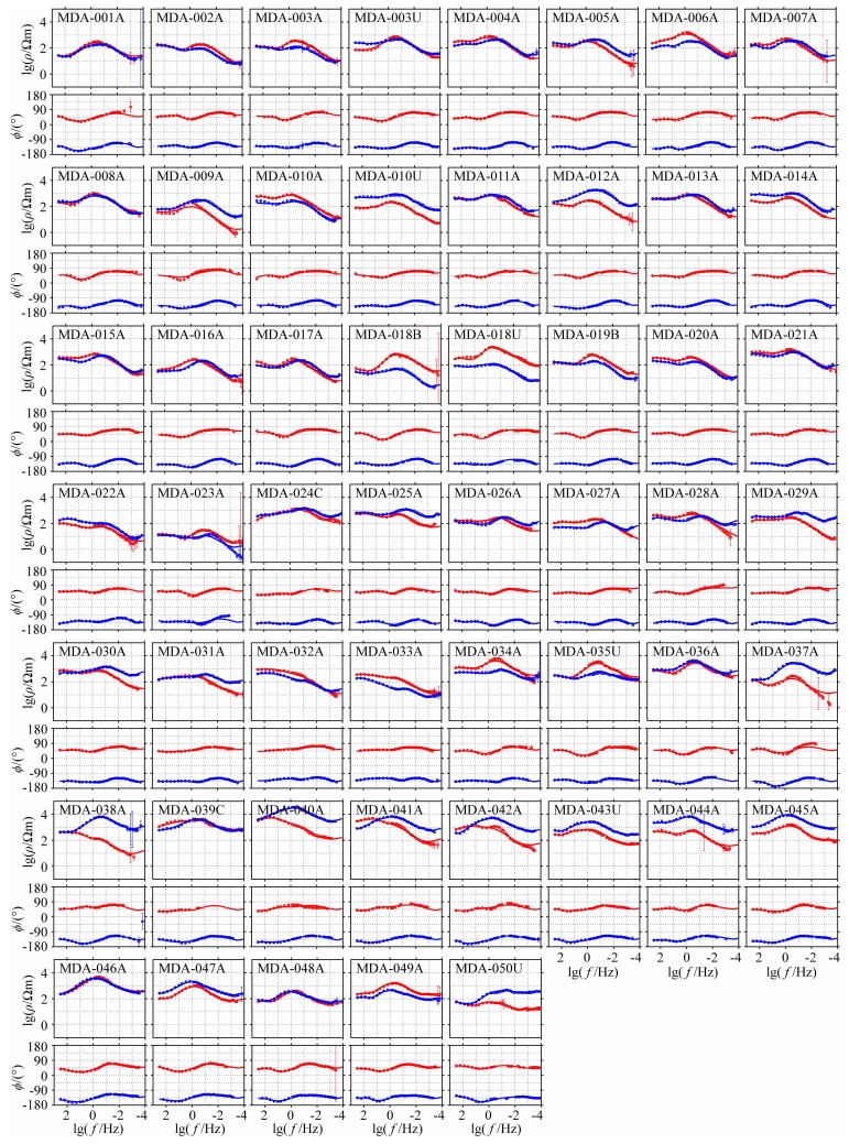
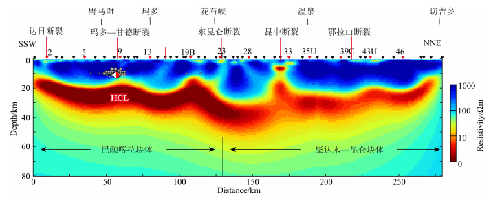
三维电磁反演使用ModEM(Egbert and Kelbert, 2012)软件系统.在反演前对沿剖面的所有测点数据频点进行插值统一,有效插值频点44个,范围320 Hz~6700 s.三维反演模型水平网格剖分包含涵盖各测点的核心部分和边界网格剖分,涵盖各测点核心部分的水平网格采用均匀剖分方式,基于测点距,本剖面上的中心区域网格密度为2.5 km×2.5 km,剖分的网格为98(南北方向)×66(东西方向)个,四个方向边界网格各有10个扩展网格,最后共有网格118×86个.垂向网格剖分采用不带地形的网格划分,首层网格厚度为20 m,网格厚度向下分段按不同比例增长,在0.5 km内的增长因子为1.2,0.5~1 km内的增长因子为1.1,在1~15 km内增长因子为1.05,在15~150 km内的增长因子为1.1,在150~500 km内的增长因子为1.2,最后划分了87层(网格剖分见附图 1).基于获取的每个测点全频段的数据中,三维反演时选取1s以上的9个频点、1s以下全部28个频点的视电阻率和阻抗相位数据,门槛误差分别为10%和2.84°,使用100 Ωm均匀半空间为初始模型,采用自动更新的正则化因子,正则化因子初始值为5000,当反演不再收敛时更新正则化因子为原有值的十分之一继续反演.经过82次迭代反演结束,获取模型均方根误差RMS为1.2,由53个测点三维反演获取的响应与实测视电阻率和阻抗相位数据拟合程度较好(图 7),附图 2给出了53个测点的曲线拟合图,附图 3给出了三维反演获取的玛多剖面深部电性结构图像.

|
附图 1 东昆仑断裂带玛多剖面三维反演网格剖分 (a)水平网格剖分图,红色圆点为大地电磁测点;(b)垂直方向网格剖分图. FigureS 1 Grid used for the 3D inversion (a) Horizontal grid. The red dots denote MT stations; (b) Vertical grid. |

|
图 7 实测与3-D模型理论计算的视电阻率和阻抗相位数据柱状图 obs表示观测数据,resp表示三维反演获取的响应数据. Fig. 7 Comparison of apparent resistivity and impedance phase of measured values and calculated values from3-D theoretical response along the profile Obs denotes observed data, and resp denotes response (predicted) data of the model. |
|
附图 2 玛多剖面三维电磁反演获取的响应(连续曲线)和实测数据(离散点)拟合曲线 红色:XY方向,蓝色:YX方向. FigureS 2 Observed (dots) apparent resistivity and phase compared with the response (lines) of the 3D model Red dots and lines denote XY mode data; blue dots and lines denote YX mode data. |
|
附图 3 玛多剖面三维反演获得的深部电性结构图 黑色圆点为玛多地震余震,震源机制球为剖面投影(GCMT, Ekström et al., 2012). FigureS 3 Deep electrical structure of Madoi earthquake region Black dots denote aftershocks of Madoi earthquake; Beach ball is profile project of Madoi earthquake focal mechanism (modify after GCMT, Ekström et al., 2012). |
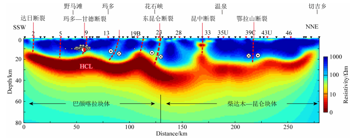
图 8给出了深部电性结构和地质解译,图中可见东昆仑断裂和昆中断裂是主要的低阻边界带,东昆仑断裂西南侧在2、9和15号测点附近存在次一级的电性差异边界.巴颜喀拉和昆仑—柴达木块体具有相似的深部电性结构特征,为高—低—次低阻的“三明治”结构,上地壳高阻体(HRB)下界面呈波浪起伏,越靠近断裂带附近上凸特征越明显,表明断裂带破碎程度高,电阻率值低,指示了断裂带良好的导电性(图 8).中下地壳赋存高导层(HCL),在巴颜喀拉块体约20 km以上,在东昆仑断裂和昆中断裂之间较深为约30 km,昆中断裂东北侧埋深逐渐变浅到约20 km附近,区域内的壳内高导层(HCL)应该指示了巴颜喀拉块体内部中下地壳的强烈缩短变形.我们把玛多主震和余震(垂直剖面两侧各10 km范围的余震)投影到电性结构图中,可以看到余震群聚在主震附近区域,玛多主震深度17 km,震源区处于上部高阻和下部高导层(HCL)的交界区且偏于高阻体内,基本位于9号测点西南侧,9号点的原始视电阻率曲线数值与两侧测点相比略低(见图 5),确实反映出该地段深部存在电性差异带,地震余震、电性结构差异带空间位置耦合,因此可以判断该点附近为玛多—甘德断裂带发育位置,即玛多地震的发震构造,这与我们通过遥感解译、余震分布确定地表断裂为玛多—甘德断裂带相符合.
|
图 8 玛多地震附近的深部电性结构图和地震构造解译 黑色圆点为玛多地震余震,震源机制球为剖面投影(GCMT, Ekström et al., 2012),黑色三角为MT测点. Fig. 8 Deep electrical structure and interpretation of Madoi earthquake region Black dots denote aftershocks of Madoi earthquake; Beach ball is profile project of Madoi earthquake focal mechanism (modify after GCMT, Ekström et al., 2012); Black triangles are MT sites. |
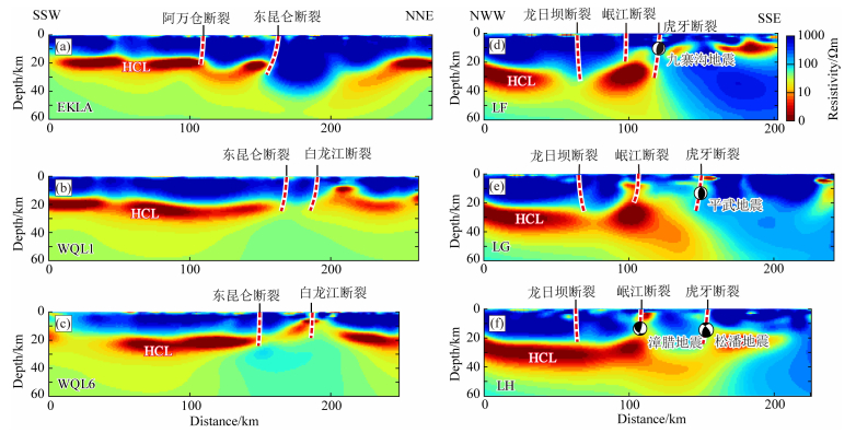
东昆仑断裂带东端部一系列破坏性中强地震频繁发生.2017年7.0级九寨沟地震发生在东昆仑断裂带东南尾端(易桂喜等,2017;Long et al., 2019),1976年松潘地震、1973年黄龙地震、1960年漳腊地震也发生在这个区域(Chen et al., 1994;王光弟,1988).针对这些地震构造以及东昆仑断裂带东部尾端的深部结构开展了三维电磁探测成像研究(Sun et al., 2019, 2020).综合跨过东昆仑断裂带东段的7条电磁探测剖面结果(图 8、图 9),我们发现,东昆仑断裂带玛曲段到东北~50 km的范围、在深度约40 km以上为较完整的高阻体(图 9a),在高阻背景下存在较陡直略向南西倾斜的电性差异带,向东剖面上的东昆仑断裂带下方的电性差异更明显(图 9b、图 9c).三条自巴颜喀拉块体到西秦岭方向的垂向电阻率结构图(图 9(d—f)),揭示1973年黄龙地震、1976年松潘地震和2017年九寨沟地震的震源区都位于电性边界带靠近高阻体一侧,处于西南侧壳内高导层(HCL)向北东侧上凸的端部,也是高、低密度物质接触区(Wu and Gao, 2019),与玛多地震震源所处深部介质电阻率组合特征一致(图 8).
|
图 9 东昆仑断裂带玛曲段(a—c)与跨龙日坝断裂带(d—f)深部电性结构图(具体剖面位置见图 2) Fig. 9 The deep electrical structure in Maqên section of East Kunlun fault (a—c) and Longriba fault (d—f) |
东昆仑断裂带玛多段和玛曲段、虎牙断裂北段—虎牙断裂一线西南侧巴颜喀拉块体发育中下地壳高导层(HCL),北东侧具有高阻特性的西秦岭造山带和碧口地块阻挡了HCL继续向北东运移.沿东昆仑断裂带东段—虎牙断裂北段—虎牙断裂一线发生的九寨沟、黄龙和松潘地震群的震源位置都聚集在巴颜喀拉块体下的中下地壳高导层HCL向北东侧运移变浅的端部,说明该地区上地壳活动受到了中下地壳HCL支配,区域中强地震的动力源自软弱的中下地壳;由于东昆仑断裂带东段—虎牙断裂北段—虎牙断裂一线的电阻率结构高低不均,使得在不同地段的应力积累能力不同,最终表现为沿该带在不同位置中强地震串珠状发生.对比玛多段(图 8)与玛曲段(图 9a—c)的深部电性结构,我们也不难发现二者具有较高的一致性,为高—低—次低阻的“三明治”结构.最近研究表明,东昆仑断裂带上目前仍存在着两个无历史地表破裂的地震空段,即东西大滩段和玛沁—玛曲段(Wen et al., 2007; Van der Woerd et al., 2002;李春峰等2004;江娃利和谢新生,2006).玛曲—玛沁段近2000a以来的古地震复发间隔自西向东分别为(600±100)和1000 a,且现今的离逝时间分别为~80, ~500和~1000 a(Li et al., 2011).玛曲—玛沁段最后一次事件离逝时间已经超出和接近其复发周期,同时考虑到2008年汶川MS8.0地震对玛沁—玛曲段造成的应力加载(Parsons.et al., 2008;单斌等,2009),以及该段处在应变场分布高值区、块体间差异运动显著,因此后续需重点关注玛曲—玛沁段的地震活动性及潜在危险性(Wen et al., 2007;张希等,2004;刘雷等,2021).
5.2 东昆仑断裂带中东段及邻区构造变形与转换新生代青藏高原大陆碰撞以来的构造变形模式目前存在两种端元模型,一种是块体逃逸模型(Molnar and Tapponnier, 1975; Tapponnier et al., 1976; 2001)认为块体沿大型走滑断裂带速率高,沿断裂带变形是吸收印度—欧亚板块之间持续汇聚缩短的主要机制;另外一种为地壳增厚模型(England and McKenzie, 1982; Houseman and England, 1993),指出沿大型走滑断裂带的滑动速率相对较小,青藏高原内部弥散分布式的地壳增厚吸收和调节着印度—欧亚板块之间的汇聚缩短.现有文献表明,沿青藏高原东北部的阿尔金断裂带,断裂的走滑位移主要被祁连山内部的构造缩短所吸收(Zhang et al., 2007;Wang et al., 2011b;Zhang et al., 2014);类似地,沿海原断裂带的走滑位移则主要被其尾端六盘山的构造缩短及其隆升吸收(Zheng et al., 2006;Wang et al., 2011b).然而,沿东昆仑断裂带,特别是中东段的走滑位移是如何被调整和吸收的,则鲜有报道.
现有研究表明,东昆仑断裂带中西段左旋走滑速率约为10 mm·a-1,且在相当长的一段距离内基本不变(Van der Woerd et al., 2002),在玛沁段大约12.5 mm·a-1速率向东侧滑移,自西向东滑动速率急剧减小,在玛曲段减少到约5 mm·a-1,到塔藏段则变为3 mm·a-1以下(Kirby et al., 2007;Li et al., 2011;Ren et al., 2013).大地电磁结果揭示东昆仑断裂带中东段不同地段具有不同高、低阻混杂的介质电阻率分布状态可能是东昆仑断裂带走滑速率向东锐减且成弥散分布的深部成因(图 9).Sun等(2019, 2020)跨过东昆仑断裂玛曲段和龙日坝断裂的6条剖面的深部电性结构图像,也揭示在东昆仑断裂带南侧的巴颜喀拉块体中下地壳广泛发育平缓的高导层(HCL),但是在靠近东昆仑断裂带附近高导层则表现出西南深—东北浅的赋存状态.在东昆仑断裂带北侧的昆仑—柴达木块体和西秦岭造山带6条剖面揭示深部电性结构特征不太一致(图 9).玛多剖面跨过了昆仑—柴达木块体东缘地段(图 8),自地表到地下几十公里范围表现为较完整的高阻特征,而其他6条跨过西秦岭造山带的大地电磁剖面探测结果则显示为呈波浪起伏的高、低、次高阻的结构特征(图 9),可能代表了东昆仑东段中下地壳广泛的缩短变形.
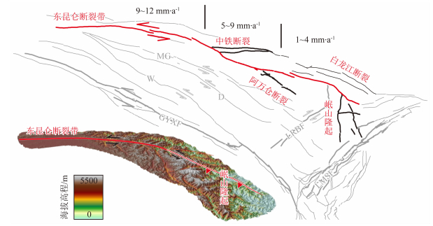
东昆仑断裂带中东段不同段落的不同深部结构图像以及两侧块体的电阻率结构特征,可以很好地解释东昆仑断裂中东段自西向东滑动速率急剧减小的特征:即在断裂带中段表现为陡立的电性边界带,容易发生滑动,再往东到断裂带尾端附近不再是单一的电性边界特征,表现为较宽范围的低阻破碎结构特征,以虎牙断裂向北延伸段为骨干电性差异带并伴随表现为电性差异带的一系列分支断裂,共同组成了更为发散的结构样式,使其承担和分解了东昆仑断裂东向的走滑速率(图 10).
|
图 10 东昆仑断裂带中东段及邻区构造变形与应变分配模式 东昆仑断裂带走滑速率数据来源Van der Woerd et al., 2002;Kirby et al., 2007;Li et al., 2011;Ren et al., 2013. Fig. 10 Pattern of deformation and strain redistribution along the central-eastern East Kunlun fault Slip rates of the East Kunlun fault are from following references: Van der Woerd et al., 2002;Kirby et al., 2007; Li et al., 2011; Ren et al., 2013. |
Kirby和Harkins(2013)利用构造地貌和GPS大地测量观测资料,同时综合分析了沿东昆仑断裂带走滑速率空间变化,指出东昆仑断裂带的走滑位移转换为断裂挤压区(如阿尼玛卿山)的构造隆升以及高原内部的缩短(图 10;Wang et al., 2011a).除上述我们的大地电磁剖面探测观察之外,在东昆仑断裂带的最东端断裂南北两侧发育一系列次级走滑断裂、逆冲断裂,表现为分布、弥散的“马尾状”样式(Zhang et al., 2006; 郑文俊等, 2013;Ren et al., 2013; Sun et al., 2018).东昆仑断裂带东段的部分走滑分量,也被认为主要转换到如岷江断裂和虎牙断裂所组成的“马尾状”尾端构造上,其余分量则被龙日坝断裂和龙门山构造带、岷山隆起等吸收(图 10;Kirby et al., 2000;Zhang et al., 2006;Ren et al., 2013;郑文俊等, 2013).
5.3 玛多MS7.4地震发震构造模式及其动力学意义大地电磁测深结果表明,青藏高原巴颜喀拉块体内部普遍存在高导层(图 8,图 9),深部结构图像揭示了在巴颜喀拉块体赋存中下地壳高导层(HCL)且埋深波浪起伏,表明中下地壳广泛遭受到了构造变形或缩短,这种深部电性结构特征有可能代表了青藏高原东缘存在中下地壳物质的流动(Clark and Royden, 2000),也有可能是由于地壳缩短过程中的重复楔形叠置(Wang et al., 2011a).玛多地震震源区正处于HCL向上凸起的地段并与上部介质中高阻和次高阻边界带衔接区域,巴颜喀拉块体的壳内高导层(HCL)埋深波浪起伏状态,是青藏高原向东北推挤的深部表现,玛多地震的发生正是由于青藏高原向东北推挤导致软弱的壳内高导层(HCL)折曲,高导层(HCL)起到了应力传导作用,使得应力运移并作用储存到上部高阻介质中,在相对薄弱的高阻和次高阻边界带附近,即玛多—甘德断裂带附近破裂而导致了玛多地震发生.总体而言,由于力学性质弱,高导层在区域应力作用下易发生剪切运动和缩短,继而导致上、下地壳间拆离或地壳增厚(Sun et al., 2020),并控制着诸如2021年玛多地震、1947年达日地震等中强地震的发生.
如前所述,巴颜喀拉块体被龙日坝断裂分隔,西北侧阿坝次级块体在南北两侧走滑速率更高的甘孜—玉树—鲜水河断裂带和东昆仑断裂带的围限下,与块体内部的走滑速率相对较低的次级断裂,如五道梁—长沙贡玛断裂、达日断裂、甘德南缘断裂、玛多—甘德断裂和阿万仓断裂等协同变形(图 2,图 11),共同调节着青藏高原不同块体的形变,由此可见巴颜喀拉块体的现今构造变形更为弥散、连续,明显有别于中国大陆内部如塔里木、柴达木、鄂尔多斯、扬子等更为刚性的块体(张培震等,2003).

|
图 11 玛多MS7.4地震发震构造模式及巴颜喀拉块体变形动力学机制 KLF,东昆仑断裂带;GYXF,甘孜—玉树—鲜水河断裂带;MG,玛多—甘德断裂;D,达日断裂;W,五道梁—长沙贡玛断裂;M,岷江断裂;H,虎牙断裂. Fig. 11 Seismogenic fault of the Madoi MS7.4 earthquake and geodynamic mechanism of tectonic deformation of the Bayan Har Block Abbreciations are: KLF, East Kunlun fault; GYXF, Garzê-Yushu-Xianshuihe fault; LMSF, Longmenshan fault zone; LRBF, Longriba fault; MG, Madoi-Gadê fault; D, Dari fault; W, Wudaoliang-Changshagongma fault; M, Minjiang fault; H, Huya fault. |
阿坝次级块体边界带东昆仑断裂带和甘孜—玉树—鲜水河断裂带走滑速率相对较高,控制着边界断裂带内如2001年昆仑山口8.1级地震、2011年玉树7.1级地震等大震、强震的发生,地震复发间隔短;块体内断裂体系主体仍以左旋走滑的水平向运动为主,控制了诸如1947年达日MS7.7地震、2021年玛多MS7.4地震的发生,复发间隔相对偏长,变形过程中的中下地壳缩短增厚有限,正如本文深部电性结构所揭示的高导层厚度(图 9a—c)要明显小于东部龙门山次级块体地区(图 9d—f)的.阿坝次级块体内部的走滑断裂向东南全部终止于龙日坝断裂,表明走滑断裂的变形完全被龙日坝断裂及其东南地区构造调节吸收(图 11);块体内部沿龙日坝断裂、五道梁—长沙贡玛断裂等地区仍存在一定的地震空区,也是库仑应力显著增加的地段(刘雷等,2021)(图 11),建议后续加强地震地质、深部孕震环境等研究工作.龙日坝断裂以东南至龙门山构造带之间龙门山次级块体内,深部电性结构揭示高导层厚度大且更加广泛,暗示着中下地壳的缩短增厚幅度明显增大,这也正好说明龙日坝断裂西北侧的水平走滑运动不断被龙日坝断裂以东南地区的缩短增厚所吸收,当高导层与巴颜喀拉块体共同向SE和NE方向运动时,受到较坚硬的四川盆地阻挡,高导层在龙门山次级块体内部不断堆积(图 11),短时间尺度内控制着如1976年松潘MS7.2地震、2008年汶川MS8.0地震、2017年九寨沟MS7.0地震的发生,长时间尺度的构造变形过程逐渐转换为龙门山次级块体的垂向隆升,形成其与四川盆地之间陡峭的地形,进一步控制着青藏高原东缘,特别是龙门山次级块体晚新生代以来的快速侵蚀剥露和地貌演化进程(图 11;Kirby et al., 2002; Clark et al., 2005; Ouimet et al., 2010; Godard et al., 2009; Cook et al., 2013; Tian et al., 2014, 2015; Guenthner et al., 2014; Tan et al., 2017).
6 结论基于2021年玛多MS7.4主震和余震分布,结合高精度卫星影像解译及活动断裂分布,本文初步判断发震断裂为东昆仑断裂带南部的玛多—甘德断裂带,大地电磁探测结果揭示震源位置位于下部高导层与上部高阻体的交界部位,区域尺度上与巴颜喀拉块体及其边界断裂带发生的中强地震震源位置具有较好的一致性,多位于块体边界显著的电性边界带附近.东昆仑断裂玛曲段三条剖面揭示出与本次玛多地震相似的深部构造背景,建议后续重点关注该段的地震活动性及潜在危险性.
由于本次玛多地震发生在巴颜喀拉块体内部的玛多—甘德断裂带上,总体来看,该断裂带是块体内部NW向左旋走滑速率相对较低的断裂体系,存在与走滑速率更高的东昆仑、甘孜—玉树—鲜水河等边界断裂之间的协同运动,不同级别的断裂系统共同调节着青藏高原块体间及块体内部的变形过程,控制着边界断裂带以及块体内部的一系列中强地震;沿龙日坝断裂、五道梁—长沙贡玛断裂等地区也存在一定的地震空区,也是库仑应力显著增加的地段,建议后续加强地震地质、深部孕震环境等研究工作.
巴颜喀拉块体现今构造变形方式与过程更为弥散连续,明显有别于中国大陆内部如塔里木、柴达木、鄂尔多斯、扬子等更为刚性的块体.与东昆仑断裂带的应变被尾端“马尾状”断裂以及阿尼玛卿山、岷山抬升隆起的调节机制相类似,龙日坝断裂西北侧阿坝次级块体内左旋走滑的水平向运动,不断被龙日坝断裂及其东南地区的中下地壳构造缩短和地壳增厚所吸收,驱动龙门山构造带及邻区的构造变形及地震发生,控制着青藏高原东缘晚新生代以来的地貌演化进程.
致谢 感谢两位匿名审稿人中肯的修改意见和建议;野外数据采集过程中曾得到杨皓、王刚、李丰权、杨涛、杨飞、杨超春、王伟、张占发的大力协助;青海省地震局、青海省果洛藏族自治州地震局、青海省海南藏族自治州地震局、玛多县地震局曾给予有力支持;陈小斌研究员、蔡军涛博士、刘钟尹博士提供三维反演计算MTP和Topeak软件及详细指导;电磁数据三维反演计算在中国地震局地质研究所超算中心进行;在此一并表示感谢.
Allen C R, Luo Z, Qian H, et al. 1991. Field study of a highly active fault zone:The Xianshuihe fault of southwestern China. GSA Bulletin, 103(9): 1178-1199. DOI:10.1130/0016-7606(1991)103<1178:FSOAHA>2.3.CO;2 |
Avouac J P, Tapponnier P. 1993. Kinematic model of active deformation in central Asia. Geophysical Research Letters, 20(10): 895-898. DOI:10.1029/93GL00128 |
Bürgmann R. 2018. The geophysics, geology and mechanics of slow fault slip. Earth and Planetary Science Letters, 495: 112-134. DOI:10.1016/j.epsl.2018.04.062 |
Becken M, Ritter O, Bedrosian P A, et al. 2011. Correlation between deep fluids, tremor and creep along the central San Andreas fault. Nature, 480(7375): 87-90. DOI:10.1038/nature10609 |
Booker J R. 2014. The magnetotelluric phase tensor:a critical review. Surveys in Geophysics, 35(1): 7-40. DOI:10.1007/s10712-013-9234-2 |
Burchfiel B C, Royden L H, Van Der Hilst R D, et al. 2008. A geological and geophysical context for the Wenchuan earthquake of 12 May 2008, Sichuan, People's Republic of China. GSA Today, 18(7): 4-11. DOI:10.1130/GSATG18A.1 |
Cai J T, Chen X B, Xu X W, et al. 2017. Rupture mechanism and seismotectonics of the MS6.5 Ludian earthquake inferred from three-dimensional magnetotelluric imaging.. Geophysical Research Letters, 44(3): 1275-1285. DOI:10.1002/2016GL071855 |
Caldwell T G, Bibby H M, Brown C. 2004. The magnetotelluric phase tensor. Geophysical Journal International, 158(2): 457-469. DOI:10.1111/j.1365-246X.2004.02281.x |
Chen C Y, Ren J W, Meng G J, et al. 2013. Division, deformation and tectonic implication of active blocks in the eastern segment of Bayan Har block. Chinese Journal of Geophysics (in Chinese), 56(12): 4125-4141. DOI:10.6038/cjg20131217 |
Chen G H, Xu X W, Wen X Z, et al. 2016. Late quaternary slip-rates and slip partitioning on the southeastern Xianshuihe fault system, Eastern Tibetan Plateau. Acta Geologica Sinica-English Edition, 90(2): 537-554. DOI:10.1111/1755-6724.12689 |
Chen S F, Wilson C J L, Deng Q D, et al. 1994. Active faulting and block movement associated with large earthquakes in the Min Shan and Longmen Mountains, northeastern Tibetan Plateau. Journal of Geophysical Research:Solid Earth, 99(B12): 24025-24038. DOI:10.1029/94JB02132 |
Chevalier M L, Leloup P H, Replumaz A, et al. 2018. Temporally constant slip rate along the Ganzi fault, NW Xianshuihe fault system, eastern Tibet. GSA Bulletin, 130(3-4): 396-410. DOI:10.1130/B31691.1 |
Chu R S, Zhu L P, and Ding Z F. 2019. Upper-mantle velocity structures beneath the Tibetan Plateau and surrounding areas inferred from triplicated P waveforms. Earth and Planetary Physics, 3(5): 444-458. DOI:10.26464/epp2019045 |
Clark M K, Royden L H. 2000. Topographic ooze:building the eastern margin of Tibet by lower crustal flow. Geology, 28(8): 703-706. DOI:10.1130/0091-7613(2000)28<703:TOBTEM>2.0.CO;2 |
Clark M K, House M A, Royden L H, et al. 2005. Late Cenozoic uplift of southeastern Tibet. Geology, 33(6): 525-528. DOI:10.1130/G21265.1 |
Cook K L, Royden L H, Burchfiel B C, et al. 2013. Constraints on Cenozoic tectonics in the southwestern Longmen Shan from low-temperature thermochronology. Lithosphere, 5(4): 393-406. DOI:10.1130/L263.1 |
Cowgill E, Gold R D, Ch en, X H, et al. 2009. Low Quaternary slip rate reconciles geodetic and geologic rates along the Altyn Tagh fault, northwestern Tibet. Geology, 37(7): 647-650. DOI:10.1130/G25623A.1 |
Dai H G. 1983. On the Dari earthquake of 1947 in Qinghai province. Northwestern Seismological Journal (in Chinese), 5(3): 71-77. |
Deng Q D, Zhang P Z, Ran Y K, et al. 2002. Basic characteristics of active tectonics of China. Science in China Series D:Earth Sciences, 46(4): 356-372. |
Deng Q D, Zhang P Z, Ran Y K, et al. 2003. Active tectonics and earthquake activities in China. Earth Science Frontiers (in Chinese), 10(S1): 66-73. |
Deng Q D, Gao X, Chen G H, et al. 2010. Recent tectonic activity of Bayankala fault block and the Kunlun-Wenchuan earthquake series of the Tibetan Plateau. Earth Science Frontiers (in Chinese), 17(5): 163-178. |
Densmore A L, Ellis M A, Li Y, et al. 2007. Active tectonics of the Beichuan and Pengguan faults at the eastern margin of the Tibetan Plateau. Tectonics, 26(4): TC4005. DOI:10.1029/2006TC001987 |
Department of Earthquake Disaster Prevention, State Seismological Bureau. 1995. The Catalogue of Chinese Historical Earthquakes (in Chinese). Beijing: Seismological Press: 1-514.
|
Egbert G D, Kelbert A. 2012. Computational recipes for electromagnetic inverse problems. Geophysical Journal International, 189(1): 251-267. DOI:10.1111/j.1365-246X.2011.05347.x |
Ekström G, Nettles M, Dziewoński A M. 2012. The global CMT project 2004-2010:centroid-moment tensors for 13, 017 earthquakes. Physics of the Earth and Planetary Interiors, 200-201: 1-9. DOI:10.1016/j.pepi.2012.04.002 |
England P, McKenzie D. 1982. A thin viscous sheet model for continental deformation. Geophysical Journal International, 70(2): 295-321. DOI:10.1111/j.1365-246X.1982.tb04969.x |
Godard V, Pik R, Lavé J, et al. 2009. Late Cenozoic evolution of the central Longmen Shan, eastern Tibet:insight from (U-Th)/He thermochronometry. Tectonics, 28(5): TC5009. DOI:10.1029/2008TC002407 |
Gold R D, Cowgill E, Arrowsmith J R, et al. 2009. Riser diachroneity, lateral erosion, and uncertainty in rates of strike-slip faulting:A case study from Tuzidun along the Altyn Tagh Fault, NW China. Journal of Geophysical Research:Solid Earth, 114(B4): BO04401. DOI:10.1029/2008JB005913 |
Gold R D, Cowgill E, Arrowsmith J R, et al. 2011. Faulted terrace risers place new constraints on the late Quaternary slip rate for the central Altyn Tagh fault, northwest Tibet. GSA Bulletin, 123(5-6): 958-978. DOI:10.1130/B30207.1 |
Guenthner W R, Reiners P W, Tian Y T. 2014. Interpreting date-eU correlations in zircon (U-Th)/He datasets:A case study from the Longmen Shan, China. Earth and Planetary Science Letters, 403: 328-339. DOI:10.1016/j.epsl.2014.06.050 |
Houseman G, England P. 1993. Crustal thickening versus lateral expulsion in the Indian-Asian continental collision. Journal of Geophysical Research:Solid Earth, 98(B7): 12233-12249. DOI:10.1029/93JB00443 |
Jiang W L, Xie X S. 2006. Characteristics of segments of surface ruptures of strong earthquakes along the east Kunlun active fault zone. Journal of Geomechanics (in Chinese), 12(2): 132-139. |
Jones L M, Han W B, Hauksson E, et al. 1984. Focal mechanisms and aftershock locations of the Songpan earthquakes of August 1976 in Sichuan, China. Journal of Geophysical Research:Solid Earth, 89(B9): 7697-7707. DOI:10.1029/JB089iB09p07697 |
Kirby E, Whipple K X, Burchfiel B C, et al. 2000. Neotectonics of the Min Shan, China:Implications for mechanisms driving Quaternary deformation along the eastern margin of the Tibetan Plateau. GSA Bulletin, 112(3): 375-393. DOI:10.1130/0016-7606(2000)1122.0.CO;2 |
Kirby E, Reiners P W, Krol M A, et al. 2002. Late Cenozoic evolution of the eastern margin of the Tibetan Plateau:Inferences from 40Ar/39Ar and (U-Th)/He thermochronology. Tectonics, 21(1): 1-1. |
Kirby E, Harkins N, Wang E Q, et al. 2007. Slip rate gradients along the eastern Kunlun fault. Tectonics, 26(2): TC2010. DOI:10.1029/2006TC002033 |
Kirby E, Harkins N. 2013. Distributed deformation around the eastern tip of the Kunlun fault. International Journal of Earth Sciences, 102(7): 1759-1772. DOI:10.1007/s00531-013-0872-x |
Li C F, He Q L, Zhao G G. 2004. Holocene slip rate along the eastern segment of the Kunlun fault. Seismology and Geology (in Chinese), 26(4): 676-687. |
Li C X, Xu X W, Wen X Z, et al. 2011. Rupture segmentation and slip partitioning of the mid-eastern part of the Kunlun Fault, north Tibetan Plateau. Science China Earth Sciences, 54(11): 1730-1745. DOI:10.1007/s11430-011-4239-5 |
Li C X, Yuan D Y, Yang H, et al. 2016. The tectonic activity characteristics of Awancang fault in the late quaternary, the sub-strand of the Eastern Kunlun fault. Seismology and Geology (in Chinese), 38(1): 44-64. |
Li Y, Cao S Y, Zhou R J, et al. 2005. Late Cenozoic Minjiang Incision rate and its constraint on the uplift of the Eastern Margin of the Tibetan Plateau. Acta Geologica Sinica (in Chinese), 79(1): 28-37. |
Liang M J, Zhou R J, Yan L, et al. 2014. The relationships between neotectonic activity of the middle segment of Dari fault and its geomorphological response, Qinghai Province, China. Seismology and Geology (in Chinese), 36(1): 28-38. |
Liang M J, Yang Y, Du F, et al. 2020. Late quaternary activity of the central segment of the Dari fault and restudy of the surface rupture zone of the 1947 M73/4 Dari earthquake, Qinghai province. Seismology and Geology (in Chinese), 42(3): 703-714. |
Liu L, Li Y J, Zhu L Y, et al. 2021. Influence of the 1947 Dari M7.7 earthquake on stress evolution along the boundary fault of the Bayan Har block:insights from numerical simulation.. Chinese Journal of Geophysics (in Chinese), 64(7): 2221-2231. DOI:10.6038/cjg2021P0194 |
Long F, Yi G X, Wang S W, et al. 2019. Geometry and tectonic deformation of the seismogenic structure for the 8 August 2017 MS 7.0 Jiuzhaigou earthquake sequence, northern Sichuan, China.. Earth and Planetary Physics, 3(3): 25-267. DOI:10.26464/epp2019027 |
Mériaux A S, Ryerson F J, Tapponnier P, et al. 2004. Rapid slip along the central Altyn Tagh Fault:Morphochronologic evidence from Cherchen He and Sulamu Tagh. Journal of Geophysical Research:Solid Earth, 109(B6): B06401. DOI:10.1029/2003JB002558 |
Molnar P, Tapponnier P. 1975. Cenozoic tectonics of Asia:Effects of a continental collision. Science, 189(4201): 419-426. DOI:10.1126/science.189.4201.419 |
Ouimet W, Whipple K, Royden L, et al. 2010. Regional incision of the eastern margin of the Tibetan Plateau. Lithosphere, 2(1): 50-63. DOI:10.1130/L57.1 |
Parsons T, Ji C, Kirby E. 2008. Stress changes from the 2008 Wenchuan earthquake and increased hazard in the Sichuan basin. Nature, 454(7203): 509-510. DOI:10.1038/nature07177 |
Peng H, Ma X M, Bai J Q, et al. 2006. Characteristics of quaternary activities of the Garzê-Yushu fault zone. Journal of Geomechanics (in Chinese), 12(3): 295-304. |
Qian H. 1988. Identification of potential seismic area along the Xianshuihe fault zone. Earthquake Research in Sichuan (in Chinese), (2): 20-28. |
Qian H, Ma S H, Gong Y. 1995. Discussions on the Minjiang Fault. Earthquake Research in China (in Chinese), 11(2): 140-146. |
Qinghai Earthquake Agency. 1984. Investigation report on the 1947 M73/4 Dari earthquake. Qinghai Province (in Chinese). |
Ren J J, Xu X W, Yeats R S, et al. 2013. Millennial slip rates of the Tazang fault, the eastern termination of Kunlun fault:Implications for strain partitioning in eastern Tibet. Tectonophysics, 608: 1180-1200. DOI:10.1016/j.tecto.2013.06.026 |
Seismological Bureau of Qinghai Province, Institute of Crustal Dynamics of China Earthquake Administration.. 1999. Eastern Kunlun Active Fault Zone (in Chinese). Beijing: Seismological Press: 1-227.
|
Shan B, Xiong X, Zheng Y, et al. 2009. Stress changes on major faults caused by MW7.9 Wenchuan earthquake, May 12, 2008. Science in China Series D:Earth Sciences, 52(5): 593-601. DOI:10.1007/s11430-009-0060-9 |
Shen Z K, Lü J N, Wang M, et al. 2005. Contemporary crustal deformation around the southeast borderland of the Tibetan Plateau. Journal of Geophysical Research:Solid Earth, 110(B11): B11409. DOI:10.1029/2004JB003421 |
Shi F, Li A, Yang X P, et al. 2013. Research on late quaternary activity of the southeastern segment of Ganzi-Yushu fault zone. Seismology and Geology (in Chinese), 35(1): 50-63. |
Sun J B, Yue H, Shen Z K, et al. 2018. The 2017 Jiuzhaigou earthquake:a complicated event occurred in a young fault system. Geophysical Research Letters, 45(5): 2230-2240. DOI:10.1002/2017GL076421 |
Sun X Y, Zhan Y, Zhao L Q, et al. 2019. Electrical structure of the Kunlun-Qinling fault system, northeastern Tibetan Plateau, inferred from 3-D inversion of magnetotelluric data. Journal of Asian Earth Sciences, 181: 103910. DOI:10.1016/j.jseaes.2019.103910 |
Sun X Y, Zhan Y, Unsworth M, et al. 2020. 3-D magnetotelluric imaging of the Easternmost Kunlun Fault:Insights into strain partitioning and the seismotectonics of the Jiuzhaigou MS7.0 earthquake.. Journal of Geophysical Research:Solid Earth, 125(5): e2020JB019731. DOI:10.1029/2020JB019731 |
Tan X B, Xu X W, Lee Y H, et al. 2017. Late Cenozoic thrusting of major faults along the central segment of Longmen Shan, eastern Tibet:evidence from low-temperature thermochronology. Tectonophysics, 712-713: 145-155. DOI:10.1016/j.tecto.2017.05.016 |
Tang R C, Han W B. 1993. Active Faults and Earthquakes in Sichuan Province (in Chinese). Beijing: Seismological Press.
|
Tapponnier P, Molnar P. 1976. Slip-line field theory and large-scale continental tectonics. Nature, 264(5584): 319-324. DOI:10.1038/264319a0 |
Tapponnier P, Molnar P. 1977. Active faulting and tectonics in China. Journal of Geophysical Research, 82(20): 2905-2930. DOI:10.1029/JB082i020p02905 |
Tapponnier P, Peltzer G, Le Dain A Y, et al. 1982. Propagating extrusion tectonics in Asia:New insights from simple experiments with plasticine. Geology, 10(12): 611-616. DOI:10.1130/0091-7613(1982)102.0.CO;2 |
Tapponnier P, Zu Z Q, Roger F, et al. 2001. Oblique stepwise rise and growth of the Tibet Plateau. Science, 294(5547): 1671-1677. DOI:10.1126/science.105978 |
Taylor M, Yin A. 2009. Active structures of the Himalayan-Tibetan orogen and their relationships to earthquake distribution, contemporary strain field, and Cenozoic volcanism. Geosphere, 5(3): 199-214. DOI:10.1130/GES00217.1 |
Tian Y T, Kohn B P, Gleadow A J W, et al. 2014. A thermochronological perspective on the morphotectonic evolution of the southeastern Tibetan Plateau. Journal of Geophysical Research:Solid Earth, 119(1): 676-698. DOI:10.1002/2013JB010429 |
Tian Y T, Kohn B P, Hu S B, et al. 2015. Synchronous fluvial response to surface uplift in the eastern Tibetan Plateau:Implications for crustal dynamics. Geophysical Research Letters, 42(1): 29-35. DOI:10.1002/2014GL062383 |
Unsworth M, Bedrosian P A. 2004. Electrical resistivity structure at the SAFOD site from magnetotelluric exploration. Geophysical Research Letters, 31(12): L12S05. DOI:10.1029/2003GL019405 |
Van Der Woerd J, Tapponnier P, Ryerson F J, et al. 2002. Uniform postglacial slip-rate along the central 600 km of the Kunlun fault (Tibet), from 26Al, 10Be, and 14C dating of riser offsets, and climatic origin of the regional morphology. Geophysical Journal International, 148(3): 356-388. DOI:10.1046/j.1365-246x.2002.01556.x |
Wang C S, Gao R, Yin A, et al. 2011a. A mid-crustal strain-transfer model for continental deformation:A new perspective from high-resolution deep seismic-reflection profiling across NE Tibet. Earth and Planetary Science Letters, 306(3-4): 279-288. DOI:10.1016/j.epsl.2011.04.010 |
Wang G D. 1988. Zhangla M6.7 earthquake on 1960.. Earthquake Research in Sichuan (in Chinese), 4: 46-50. |
Wang M, Shen Z K. 2020. Present-Day crustal deformation of continental China derived from GPS and its tectonic implications. Journal of Geophysical Research:Solid Earth, 125(2): e2019JB018774. DOI:10.1029/2019JB018774 |
Wang S Y. 1999. The Catalogue of Chinese Modern Earthquakes (in Chinese). Beijing: Science and Technology of China Press: 1-637.
|
Wang W T, Zhang P Z, Kirby E, et al. 2011b. A revised chronology for Tertiary sedimentation in the Sikouzi basin:Implications for the tectonic evolution of the northeastern corner of the Tibetan Plateau. Tectonophysics, 505(1-4): 100-114. DOI:10.1016/j.tecto.2011.04.006 |
Wang X B, Zhang G, Fang H, et al. 2014. Crust and upper mantle resistivity structure at middle section of Longmenshan, eastern Tibetan plateau. Tectonophysics, 619-620: 143-148. DOI:10.1016/j.tecto.2013.09.011 |
Wen X Z, Xu X W, Zheng R Z, et al. 2003. Average slip-rate and recent large earthquake ruptures along the Garzê-Yushu fault. Science in China Series D:Earth Sciences (in Chinese), 46(2): 276-288. |
Wen X Z, Yi G X, Xu X W. 2007. Background and precursory seismicities along and surrounding the Kunlun fault before the MS8.1, 2001, Kokoxili earthquake. Journal of Asian Earth Sciences, 30(1): 63-72. DOI:10.1016/j.jseaes.2006.07.008 |
Wen X Z. 2018. The 2008 Wenchuan, 2013 Lushan and 2017 Jiuzhaigou earthquakes, Sichuan, in the last more than one thousand years of rupture history of the eastern margin of the Bayan Har block. Acta Seismologica Sinica (in Chinese), 40(3): 255-267. |
Wu Y, Gao Y. 2019. Gravity pattern in southeast margin of Tibetan Plateau and its implications to tectonics and large earthquakes. Earth and Planetary Physics, 3(5): 425-434. DOI:10.26464/epp2019044 |
Xiao Q B, Yu G, Jing L Z, et al. 2017. Structure and geometry of the Aksay restraining double bend along the Altyn Tagh Fault, northern Tibet, imaged using magnetotelluric method. Geophysical Research Letters, 44(9): 4090-4097. DOI:10.1002/2017GL072581 |
Xiong R W, Ren J W, Zhang J L, et al. 2010. Late Quaternary active characteristics of the gande segment in the Maduo-Gande Fault Zone. Earthquake (in Chinese), 30(4): 65-73. |
Xu R, Stamps D S. 2016. Present-day kinematics of the eastern Tibetan Plateau and Sichuan Basin:Implications for lower crustal rheology. Journal of Geophysical Research:Solid Earth, 121(5): 3846-3866. DOI:10.1002/2016JB012839 |
Xu X W, Chen W B, Ma W T, et al. 2002. Surface rupture of the Kunlunshan earthquake (MS8.1), northern Tibetan Plateau, China.. Seismological Research Letters, 73(6): 884-892. DOI:10.1785/gssrl.73.6.884 |
Xu X W, Chen W B, Yu G H, et al. 2002. Characteristic features of the Hoh Sai Hu (Kunlunshan) earthquake (MS8.1), Northern Tibetan Plateau, China.. Seismology and Geology (in Chinese), 24(1): 1-13. |
Xu X W, Yu G H, Klinger Y, et al. 2006. Reevaluation of surface rupture parameters and faulting segmentation of the 2001 Kunlunshan earthquake (MW7.8), northern Tibetan Plateau, China.. Journal of Geophysical Research:Solid Earth, 111(B5): B05316. DOI:10.1029/2004JB003488 |
Xu X W, Wen X Z, Chen G H, et al. 2008. Discovery of the Longriba fault zone in eastern Bayan Har block, China and its tectonic implication. Science in China Series D:Earth Sciences, 51(9): 1209-1223. DOI:10.1007/s11430-008-0097-1 |
Yan L, Li Y, Zhao G H, et al. 2013. Study on the late quaternary activity characteristics and its tectonic geomorphology response of the middle segment of Dari fault in the Northeastern Tibetan Plateau. Acta Geologica Sinica-English Edition, 87(S1): 403-405. |
Ye S Q, Zhang Q F. 1993. Study of the seismic structure[ML=73/4, 1947] with remote sensing method in Dari Qinghai. Remote Sensing for Land & Resources (in Chinese), 5(2): 28-33. |
Yi G X, Long F, Liang M J, et al. 2017. Focal mechanism solutions and seismogenic structure of the 8 August 2017 M7.0 Jiuzhaigou earthquake and its aftershocks, northern Sichuan.. Chinese Journal of Geophysics (in Chinese), 60(10): 4083-4097. DOI:10.6038/cjg20171033 |
Yin A, Harrison T M. 2000. Geologic evolution of the Himalayan-Tibetan Orogen. Annual Review of Earth and Planetary Sciences, 28: 211-280. DOI:10.1146/annurev.earth.28.1.211 |
Zhan Y, Zhao G Z, Unsworth M, et al. 2013. Deep structure beneath the southwestern section of the Longmenshan fault zone and seimogenetic context of the 4.20 Lushan MS7.0 earthquake.. Chinese Science Bulletin, 58(28-29): 3467-3474. DOI:10.1007/s11434-013-6013-x |
Zhan Y, Yang H, Zhao G Z, et al. 2017. Deep electrical structure of crust beneath the Madongshan step area at the Haiyuan fault in the northeastern margin of the Tibetan plateau and tectonic implications. Chinese Journal of Geophysics (in Chinese), 60(6): 2371-2384. DOI:10.6038/cjg20170627 |
Zhang H P, Liu S F, Yang N, et al. 2006. Geomorphic characteristics of the Minjiang drainage basin (eastern Tibetan Plateau) and its tectonic implications:New insights from a digital elevation model study. Island Arc, 15(2): 239-250. DOI:10.1111/j.1440-1738.2006.00524.x |
Zhang H P, Zhang P Z, Zheng D W, et al. 2014. Transforming the Miocene Altyn Tagh fault slip into shortening of the north-western Qilian Shan:insights from the drainage basin geometry. Terra Nova, 26(3): 216-221. DOI:10.1111/ter.12089 |
Zhang P Z, Deng Q D, Zhang G M, et al. 2003. Active tectonic blocks and strong earthquakes in the continent of China. Science in China Series D:Earth Sciences, 46(2): 13-24. |
Zhang P Z, Shen Z K, Wang M, et al. 2004. Continuous deformation of the Tibetan Plateau from global positioning system data. Geology, 32(9): 809-812. DOI:10.1130/G20554.1 |
Zhang P Z, Molnar P, Xu X W. 2007. Late Quaternary and present-day rates of slip along the Altyn Tagh Fault, northern margin of the Tibetan Plateau. Tectonics, 26(5): TC5010. DOI:10.1029/2006TC002014 |
Zhang P Z, Xu X W, Wen X Z, et al. 2008. Slip rates and recurrence intervals of the Longmen Shan active fault zone and tectonic implications for the mechanism of the May 12 Wenchuan earthquake, 2008, Sichuan, China. Chinese Journal of Geophysics (in Chinese), 51(4): 1066-1073. |
Zhang P Z. 2013. A review on active tectonics and deep crustal processes of the Western Sichuan region, eastern margin of the Tibetan Plateau. Tectonophysics, 584: 7-22. DOI:10.1016/j.tecto.2012.02.021 |
Zhang X, Jiang Z S, Wang Q, et al. 2004. Tectonic deformation features of the northern Tibetan Plateau and their relationship to strong earthquakes. Progress in Geophysics (in Chinese), 19(2): 363-371. |
Zhao G Z, Unsworth M J, Zhan Y, et al. 2012. Crustal structure and rheology of the Longmenshan and Wenchuan MW7.9 earthquake epicentral area from magnetotelluric data.. Geology, 40(12): 1139-1142. DOI:10.1130/G33703.1 |
Zhao L Q, Zhan Y, Zhao G Z, et al. 2015. The Deismogenic environment of the 2013 Minxian-Zhangxian MS6.6 earthquake based on the deep electrical structure.. Seismology and Geology (in Chinese), 37(2): 541-554. |
Zhao L Q, Zhan Y, Sun X Y, et al. 2019. The hidden seismogenic structure and dynamic environment of the 21 January Menyuan, Qinghai, MS6.4 earthquake derived from magnetotelluric imaging.. Chinese Journal of Geophysics (in Chinese), 62(6): 2088-2100. DOI:10.6038/cjg2019M0204 |
Zhao X L, Deng Q D, Chen S F. 1994. Tectonic geomorphology of the Minshan uplift in western Sichuan, southwestern China. Seismology and Geology (in Chinese), 16(4): 429-439. |
Zheng D W, Zhang P Z, Wan J L, et al. 2006. Rapid exhumation at ~8 Ma on the Liupan Shan thrust fault from apatite fission-track thermochronology:Implications for growth of the northeastern Tibetan Plateau margin. Earth and Planetary Science Letters, 248(1-2): 198-208. DOI:10.1016/j.epsl.2006.05.023 |
Zheng W J, Yuan D Y, He W G, et al. 2013. Geometric pattern and active tectonics in Southeastern Gansu province:Discussion on seismogenic mechanism of the Minxian-Zhangxian MS6.6 earthquake on July 22, 2013.. Chinese Journal of Geophysics (in Chinese), 56(12): 4058-4071. DOI:10.6038/cjg20131211 |
Zhou R J, Ma S H, Cai C X. 1996. Late quaternary active features of the Ganzi-Yushu fault zone. Earthquake Research in China (in Chinese), 12(3): 250-260. |
Zhou R J, Wen X Z, Chai C X, et al. 1997. Recent earthquakes and assessment of seismic tendency on the Ganzi-Yushu fault zone. Seismology and Geology (in Chinese), 19(2): 20-29. |
Zhou R J, Pu X H, He Y L, et al. 2000. Recent activity of Minjiang fault zone, uplift of Minshan block and their relationship with seismicity of Sichuan. Seismology and Geology (in Chinese), 22(3): 285-294. |
Zhu H, Wen X Z. 2009. Stress triggering process of the 1973 to 1976 Songpan, Sichuan, sequence of strong earthquakes. Chinese Journal of Geophysics (in Chinese), 52(4): 994-1003. DOI:10.3969/j.issn.0001-5733.2009.04.016 |
陈长云, 任金卫, 孟国杰, 等. 2013. 巴颜喀拉块体东部活动块体的划分、形变特征及构造意义. 地球物理学报, 56(12): 4125-4141. DOI:10.6038/cjg20131217 |
戴华光. 1983. 1947年青海达日73/4级地震. 西北地震学报, 5(3): 71-77. |
邓起东, 张培震, 冉勇康, 等. 2002. 中国活动构造基本特征. 中国科学(D辑), 46(4): 1020-1030. |
邓起东, 张培震, 冉勇康, 等. 2003. 中国活动构造与地震活动. 地学前缘, 10(S1): 66-73. |
邓起东, 高翔, 陈桂华, 等. 2010. 青藏高原昆仑-汶川地震系列与巴颜喀喇断块的最新活动. 地学前缘, 17(5): 163-178. |
国家地震局震害防御司. 1995. 中国历史强震目录. 北京: 地震出版社: 1-514.
|
江娃利, 谢新生. 2006. 东昆仑活动断裂带强震地表破裂分段特征. 地质力学学报, 12(2): 132-139. DOI:10.3969/j.issn.1006-6616.2006.02.004 |
李春峰, 贺群禄, 赵国光. 2004. 东昆仑活动断裂带东段全新世滑动速率研究. 地震地质, 26(4): 676-687. DOI:10.3969/j.issn.0253-4967.2004.04.013 |
李陈侠, 袁道阳, 杨虎, 等. 2016. 东昆仑断裂带东段分支断裂——阿万仓断裂晚第四纪构造活动特征. 地震地质, 38(1): 44-64. DOI:10.3969/j.issn.0253-4967.2016.01.004 |
李勇, 曹叔尤, 周荣军, 等. 2005. 晚新生代岷江下蚀速率及其对青藏高原东缘山脉隆升机制和形成时限的定量约束. 地质学报, 79(1): 28-37. DOI:10.3321/j.issn:0001-5717.2005.01.004 |
梁明剑, 周荣军, 闫亮, 等. 2014. 青海达日断裂中段构造活动与地貌发育的响应关系探讨. 地震地质, 36(1): 28-38. DOI:10.3969/j.issn.0253-4967.2014.01.003 |
梁明剑, 杨耀, 杜方, 等. 2020. 青海达日断裂中段晚第四纪活动性与1947年M73/4地震地表破裂带再研究. 地震地质, 42(3): 703-714. DOI:10.3969/j.issn.0253-4967.2020.03.011 |
刘雷, 李玉江, 朱良玉, 等. 2021. 1947年达日M7.7地震对巴颜喀拉块体边界断裂应力影响的数值模拟.. 地球物理学报, 64(7): 2221-2231. |
彭华, 马秀敏, 白嘉启, 等. 2006. 甘孜玉树断裂带第四纪活动特征. 地质力学学报, 12(3): 295-304. DOI:10.3969/j.issn.1006-6616.2006.03.003 |
钱洪. 1988. 鲜水河断裂带上潜在震源区的地质学判定. 四川地震, (2): 20-28. |
钱洪, 马声浩, 龚宇. 1995. 关于岷江断裂若干问题的讨论. 中国地震, 11(2): 140-146. |
青海省地震局. 1984.青海省达日1947年7 3/4级地震考察报告.
|
青海省地震局, 中国地震局地壳应力研究所. 1999. 东昆仑活动断裂带. 北京: 地震出版社: 1-227.
|
单斌, 熊熊, 郑勇, 等. 2009. 2008年5月12日MW7.9汶川地震导致的周边断层应力变化.. 中国科学D辑:地球科学, 39(5): 537-545. |
石峰, 李安, 杨晓平, 等. 2013. 甘孜-玉树断裂带东南段晚第四纪活动性研究. 地震地质, 35(1): 50-63. DOI:10.3969/j.issn.0253-4967.2013.01.004 |
唐荣昌, 韩渭宾. 1993. 四川活动断裂与地震. 北京: 地震出版社.
|
王光弟. 1988. 1960年漳腊M6.7级地震.. 四川地震, 4: 46-50. |
汪素云. 1999. 中国近代地震目录. 北京: 中国科学技术出版社: 1-637.
|
闻学泽, 徐锡伟, 郑荣章, 等. 2003. 甘孜-玉树断裂的平均滑动速率与近代大地震破裂. 中国科学(D辑), 33(S1): 199-208. |
闻学泽. 2018. 巴颜喀拉块体东边界千年破裂历史与2008年汶川、2013年芦山和2017年九寨沟地震. 地震学报, 40(3): 255-267. |
熊仁伟, 任金卫, 张军龙, 等. 2010. 玛多-甘德断裂甘德段晚第四纪活动特征. 地震, 30(4): 65-73. |
徐锡伟, 陈文彬, 于贵华, 等. 2002. 2001年11月14日昆仑山库赛湖地震(MS8.1)地表破裂带的基本特征.. 地震地质, 24(1): 1-13. |
徐锡伟, 闻学泽, 陈桂华, 等. 2008. 巴颜喀拉地块东部龙日坝断裂带的发现及其大地构造意义. 中国科学D辑:地球科学, 38(5): 529-542. DOI:10.3321/j.issn:1006-9267.2008.05.001 |
叶世强, 张启富. 1993. 青海达日1947年73/4级地震构造的遥感研究. 国土资源遥感, 5(2): 28-33. |
易桂喜, 龙锋, 梁明剑, 等. 2017. 2017年8月8日九寨沟M7.0地震及余震震源机制解与发震构造分析.. 地球物理学报, 60(10): 4083-4097. |
詹艳, 杨皓, 赵国泽, 等. 2017. 青藏高原东北缘海原构造带马东山阶区深部电性结构特征及其构造意义. 地球物理学报, 60(6): 2371-2384. |
张培震, 邓起东, 张国民, 等. 2003. 中国大陆的强震活动与活动地块. 中国科学(D辑), 33(S1): 12-20. |
张培震, 徐锡伟, 闻学泽, 等. 2008. 2008年汶川8.0级地震发震断裂的滑动速率、复发周期和构造成因.. 地球物理学报, 51(4): 1066-1073. |
张希, 江在森, 王琪, 等. 2004. 青藏高原北部地区构造变形特征及与强震关系. 地球物理学进展, 19(2): 363-371. DOI:10.3969/j.issn.1004-2903.2004.02.024 |
赵凌强, 詹艳, 赵国泽, 等. 2015. 基于深部电性结构特征的2013年甘肃岷县漳县MS6.6地震孕震环境探讨.. 地震地质, 37(2): 541-554. |
赵凌强, 詹艳, 孙翔宇, 等. 2019. 利用大地电磁技术揭示2016年1月21日青海门源MS6.4地震隐伏地震构造和孕震环境.. 地球物理学报, 62(6): 2088-2100. |
赵小麟, 邓起东, 陈社发. 1994. 岷山隆起的构造地貌学研究. 地震地质, 16(4): 429-439. |
郑文俊, 袁道阳, 何文贵, 等. 2013. 甘肃东南地区构造活动与2013年岷县-漳县MS6.6级地震孕震机制.. 地球物理学报, 56(12): 4058-4071. |
周荣军, 马声浩, 蔡长星. 1996. 甘孜-玉树断裂带的晚第四纪活动特征. 中国地震, 12(3): 250-260. |
周荣军, 闻学泽, 蔡长星, 等. 1997. 甘孜-玉树断裂带的近代地震与未来地震趋势估计. 地震地质, 19(2): 20-29. |
周荣军, 蒲晓虹, 何玉林, 等. 2000. 四川岷江断裂带北段的新活动、岷山断块的隆起及其与地震活动的关系. 地震地质, 22(3): 285-294. DOI:10.3969/j.issn.0253-4967.2000.03.009 |
朱航, 闻学泽. 2009. 1973~1976年四川松潘强震序列的应力触发过程. 地球物理学报, 52(4): 994-1003. DOI:10.3969/j.issn.0001-5733.2009.04.016 |
 2021, Vol. 64


