 2021, Vol. 64


2. 北京大学石油与天然气研究中心, 北京 100871;
3. 地质矿产资源部北京铀地质研究所, 北京 100029
2. Institute of Oil and Gas, School of Earth and Space Sciences, Peking University, Beijing 100871, China;
3. Division of Geology and Mineral Resources, Beijing Research Institute of Uranium Geology, Beijing 100029, China
洋中脊的海底构造特征和其运动学特征密切相关,不同扩张速率的洋中脊具有不同的洋壳热结构(Behn et al., 2002; Carbotte et al., 2016; Macdonald, 1982; Shaw, 1992).一般认为,快速和中速扩张洋中脊轴部具有较高的地形,其下部岩浆补给充足,洋中脊轴向上具有稳定的洋壳热结构,洋壳厚度约为6.7 km(Canales et al., 2003);而在慢速和超慢速扩张洋中脊,由于岩浆补给相对匮乏,洋中脊轴向热结构不稳定,其轴部通常发育中央裂谷,轴向洋壳厚度差异很大,表现为从洋中脊段中部向末端厚度呈现减薄的趋势,洋中脊段末端洋壳厚度通常为2~3 km(Lin and Morgan, 1992; Searle, 2013).
前人研究发现,洋中脊周缘区域构造背景同样影响着洋壳厚度分布特征(Goff et al., 1995; Morgan and Chen, 1993; Tucholke and Lin, 1994).地震实验发现,全球洋壳平均厚度约为7.1 km(White et al., 1992),而在西南印度洋中脊区域存在洋壳缺失现象,地幔岩石在拆离断层的深掘过程中直接裸露于海底表面形成洋底核杂岩(Sauter et al., 2013);相反,在毗邻冰岛热点的北大西洋区域形成的洋壳厚度可达20~40 km(Jenkins et al., 2017).在慢速扩张洋中脊中,洋壳厚度变化受内部构造间断的影响,在转换断层和非转换不连续间断处,洋壳厚度相对于洋中脊段减薄约2 km(Carbotte et al., 2016).假设岩浆迁移至洋中脊下部部分熔融区后以相近的析出效率形成洋壳,洋壳厚度便能很好地反映区域岩浆补给情况,对于研究洋中脊及周缘岩浆活动和区域构造演化具有很好的指示意义.
西北印度洋中脊包含中印度洋中脊和卡斯伯格洋中脊,是典型的慢速扩张洋中脊(Pak et al., 2017).目前,西北印度洋中脊的研究与勘探程度相对较低,仅在中印度洋中脊和卡斯伯格洋中脊南部进行过精细的地质调查(Raju et al., 2008; Pak et al., 2017).前人对西北印度洋中脊的地质研究,主要通过多波束地形测高、卫星测高重力和磁力异常等大尺度地球物理勘探手段,借助于海底岩石样品地球化学分析进行研究,获得了一些区域的地质构造特征及地球化学特征:Pak等(2017)利用多波束地形测高对中印度洋中脊进行构造解译,获得了多个洋底核杂岩海底地貌特征;Torsvik等(2013)根据岩石分析结果认为西北印度洋在形成过程中受留尼汪地幔柱的影响而产生多个微陆块,改变了大洋岩石圈的结构和组成;Fontaine等(2015)借助地震数据对留尼汪至毛里求斯下部岩石结构进行研究,发现岩石圈厚度向东具有减薄的特征;Barruol等(2019)利用地震层析成像技术获取了留尼汪热点及邻近的中印度洋中脊下部岩石圈及地幔的热结构;余星等(2019)对西北印度洋全区的构造演化过程进行了讨论,厘定了其内部构造特征.但是并没有研究来细致讨论西北印度洋中脊和区域内构造活动的动力学联系以及两者相互作用下岩浆迁移和补给的特征.
目前获取准确的二维洋壳结构主要是通过地震手段,但由于其耗资巨大和研究范围有限,在西北印度洋并未大范围应用,仅在马斯克林洋底高原和查戈斯—拉克代夫海岭区域进行过地震反射实验(Fontaine et al., 2015; Francis and Shor, 1966).利用重力数据反演计算洋壳厚度是研究大尺度岩浆补给活动的有效研究方法之一(Suo et al., 2017; Wang et al., 2011).本文以西北印度洋51°E—77°E,26°S—20°N区域作为研究区,利用全球高精度水深数据和重力数据计算剩余地幔布格重力异常,运用Parker-Oldenburg算法反演了覆盖研究区的洋壳厚度.根据反演的洋壳厚度分布特征,探讨西北印度洋区域岩浆补给状态,以及周缘构造活动对洋壳厚度分布的影响,有助于理解西北印度洋区域岩浆与构造演化过程.
1 地质背景西北印度洋位于印度大陆与非洲大陆之间,北接红海,南部与南大洋相连(图 1).西北印度洋中脊是印度洋“入”字型洋中脊系统的西北支,与东南印度洋中脊和西南印度洋中脊对应,南端为罗德里格斯三连点,北端为亚丁—欧文—卡尔斯伯格洋中脊三联点,是索马里板块和印澳板块之间的离散型板块边界,包含中印度洋中脊和卡斯伯格洋中脊(Raju et al., 2008).洋中脊两侧发育多个深海盆地,包括索马里深海盆地、阿拉伯深海盆地、中印度洋深海盆地等.洋中脊两侧发育的马斯克林洋底高原和查戈斯—拉克代夫海岭均为留尼汪热点喷发的产物,受中印度洋洋中脊扩张影响裂解为南、北两段.

|
图 1 西北印度洋构造纲要图 底图为海底地形图,地形数据来自SRTM 15+ (Tozer et al., 2019) Fig. 1 Tectonic map of the Northwest Indian Ocean. The bathymetric data is from SRTM 15+ (Tozer et al., 2019) |
西北印度洋中脊是慢速扩张洋中脊,全扩张速率为22~55 mm·a-1(DeMets et al., 2010;Pak et al., 2017),并且由北至南呈现速率增加的趋势.卡斯伯格洋中脊构造分段性不明显,其内部大型转换断层发育较少(图 1),在转换断层不发育的区域,洋中脊由非转换不连续间断连接,在地形上显示为不连续洋中脊段,但洋中脊未被错断(韩喜球等, 2012).中印度洋中脊构造分段性相对明显,受板块活动影响洋中脊被多个转换断层错断,断距较大.
2 洋壳厚度反演方法 2.1 数据来源本文使用的水深数据为Tozer等(2019)发布的全球测高地形数据(SRTM15+),空间分辨率可达15弧秒;地壳年龄数据为Müller等(2013)发布的空间分辨率为2弧分的洋壳年龄数据;沉积物厚度数据来自Straume等(2019)提供的全球沉积物厚度数据(GlobSed),该数据在Divins(2003)和Whittaker等(2013)研究的基础上对一些地区的海底沉积物厚度进行了补充,数据空间分辨率为5弧分;空间重力异常数据采用Sandwell等(2014)发布的全球海洋重力数据,该数据整合了CryoSat-2和Jason-1的卫星雷达数据,其精度可达2 mGal.
2.2 重力异常的校正与计算本文利用Parker(1973)的方法,通过快速傅里叶变换的方法将网格数据的空间域转换为频率域进行计算校正.假定海水、洋壳和地幔密度分别为1.03×10³ kg·m-3、2.7×10³ kg·m-3和3.3×10³ kg·m-3的条件下,在去除海水及沉积物的重力影响和参考洋壳厚度(6 km)的影响后,得到地幔布格重力异常(MBA,图 2b),MBA主要反映洋壳厚度的变化以及地幔温度的不均一性(Wang et al., 2011).

|
图 2 (a) 西北印度洋空间重力异常(FAA);(b)地幔布格重力异常(MBA);(c)岩石圈冷却产生的重力异常;(d)剩余地幔布格重力异常(RMBA) Fig. 2 (a) Satellite-derived free-air anomaly (FAA); (b) Calculated mantle Bouguer anomaly (MBA); (c) Gravity anomaly caused by lithosphere thermal cooling; (d) Calculated residual mantle Bouguer anomaly (RMBA) |
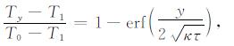
通常认为洋中脊下部软流圈上涌,岩浆经过减压熔融、析出的过程后形成玄武岩洋壳,在板块运动的作用下向洋中脊两侧扩张,随着洋壳年龄的增长岩石圈会发生热沉降和热收缩效应而具有密度增加和厚度变大的特征(Niu and Green, 2018),这种效应为岩石圈地幔的冷却效应.从MBA中除去冷却效应引起的不均衡重力异常,得到剩余地幔布格重力异常(RMBA),此方法是对大洋MBA值的进一步校正.利用RMBA数据可以更准确地反映海底莫霍面的起伏变化.为了消除岩石圈地幔冷却效应产生的重力异常,本文根据Turcotte和Schubert(2014)热力学公式建立一维岩石圈热结构模型,假定模型的顶部温度T0为0 ℃和底部(深度125 km)温度T1为1350 ℃(正常洋中脊地幔潜热),然后采用分层计算的方法获得不同深度层的岩石圈温度:
|
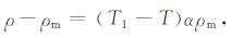
式中τ为洋壳年龄(单位为Ma),Ty为不同深度y(单位为m)的岩石圈温度,κ为热扩散系数(取1.0×10⁻⁶ m2·s-1),erf为误差函数.代入洋壳年龄数据,得到岩石圈三维热结构模型,将整个岩石圈划分为20层,每层的密度都以地幔岩石圈的密度为标准进行转换,可以得到岩石圈热收缩状态下每层岩石圈的密度(Turcotte and Schubert, 2014):
|
式中,ρ为岩石圈密度(单位为kg·m-3),ρ0为地幔岩石圈密度3.3×10³ kg·m-3,T为每层岩石圈温度,T1为地幔岩石圈温度1350 ℃,α为体积热膨胀系数(本文取3.0×10⁻⁵K-1).最后将这20层的重力效应进行叠加,得到由于岩石圈冷却效应产生的岩石圈重力异常(图 2c).从MBA中去除此效应即得到RMBA(图 2d).RMBA一般反映洋壳厚度、地幔亏损程度、地幔温度和地幔孔隙度变化(索艳慧, 2014).在假定研究区内洋壳与地幔密度均一的情况下,所有的RMBA变化都是由地壳厚度变化引起的,即RMBA可以直观地反映大洋岩石圈底部莫霍面的起伏状态.
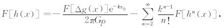
2.3 计算洋壳厚度本文采用Parker-Oldenburg算法(Gómez-Ortiz and Agarwal, 2005),根据西北印度洋RMBA数据反演研究区下伏莫霍面相对深度:
|
式中F[Δg(x)]是RMBA的傅里叶变换,ρ是地幔与地壳密度差值,k是波数,h(x)是莫霍面的相对深度,G是引力常量,n为迭代次数,z0是参考莫霍面深度,反演后得到研究区相对莫霍面深度.
利用RMBA反演计算的莫霍面地形是一个相对值,需要减去研究区内一个参考莫霍面深度获得绝对莫霍面深度.本文参考Francis和Shor(1966)研究成果,选取Scripps Institution of Oceanography在西北印度洋地区设立的1号地震反射基站(位置见Francis and Shor, 1966)所观测到的莫霍面深度作为参考莫霍面深度进而得到整个研究区绝对莫霍面深度.最后将计算得到的莫霍面深度减去水深和海底沉积物厚度,获得西北印度洋区域洋壳厚度(图 4).

|
图 4 (a) 西北印度洋洋壳厚度分布图;(b) 三种洋壳厚度分布及洋中脊分段图 Fig. 4 (a) Map of oceanic crustal thickness for Northwest Indian Ocean; (b) The distribution of three types of oceanic crust: thin crust (< 4.5 km), normal crust (4.5~6.5 km) and thick crust (> 6.5 km), and the segmentation of NWIR |
将绝对莫霍面深度和洋壳厚度计算结果与研究区内现有的地震观测数据(Francis and Shor, 1966)进行对比,发现绝对莫霍面深度数据的均方根误差为1.4 km,而洋壳厚度数据的均方根误差为1.1 km.在一些站点,如位于中印度洋中脊中部的地震基站12和14(位置见文献Francis and Shor, 1966,下同)所观测到的洋壳厚度为6.7 km和6.1 km,而反演获得的洋壳厚度为6.4 km和6.5 km,洋壳厚度误差可控制在0.4 km范围内;在位于查戈斯海沟的地震基站6和7观测到的洋壳厚度为5.1 km和5.7 km,而反演获得的洋壳厚度为5.6 km和6.7 km,可以看出反演结果与地震基站观测到的洋壳厚度相近,误差整体控制在1 km范围内.
根据过洋底高原的地震反射数据显示,过马尔代夫—查戈斯的地震基站HMDM和KAAM显示的洋壳厚度为20 km和18 km(位置及洋壳厚度信息见Fontaine et al., 2015),本文重力反演得到的洋壳厚度为21 km和18.2 km.过马尔代夫剖面显示马尔代夫洋壳厚度在10~25 km(Kunnummal et al., 2018),本文计算的结果为10~22.5 km.在马斯克林洋底高原南部地震反射剖面显示的洋壳厚度为5~15 km(Francis and Shor, 1966),本文反演的结果为8~14 km.在过塞舌尔群岛地震反射剖面显示的洋壳厚度为5.4~7.8 km(Francis and Shor, 1966),而反演得到的厚度为6.4~7.7 km.根据对比结果显示,本文所反演的洋壳厚度模型在洋中脊及多个洋底构造单元区域具有较高的可靠性,可以较好地反映区域洋壳厚度差异及变化.
3 结果空间重力异常较好地显示了西北印度洋区域地形变化情况(图 2a).整体上看,西北印度洋中脊具有高重力异常值.地形上的强烈差异反映了局部构造活动的强烈差异,洋中脊段内大型断裂及两侧深海盆地具有较低重力异常值,而洋中脊两侧出现的大范围空间重力正异常则与海底多个洋底高原的形成相关(Small and Danyushevsky, 2003).
布格重力异常反映了地壳深部物质密度及基底的起伏情况,在一定程度上可以指示区域地壳厚度的变化.根据布格重力异常显示(图 2b),洋中脊南北两端洋壳相对于中段(5°S—5°N)洋壳厚度较小,反映洋中脊中段洋壳增生量较低,岩浆的补给量不足,洋中脊扩张需要通过拆离断层或者一系列正断层完成,这种现象在一些中印度洋中脊的研究中得到证实(Pak et al., 2017).在洋中脊两侧洋底高原区域显示较低的布格重力异常,反映区域洋壳厚度较大或是下部洋壳物质密度较大;而在洋中脊两侧深海盆地则显示布格重力正异常,反映区域洋壳厚度较低.值得注意的是,留尼汪热点区域显示布格重力负异常,反映充足的岩浆补给状态下,洋壳增生量较高,形成的洋壳较厚.
洋壳厚度模型显示(图 3),西北印度洋平均洋壳厚度为7.8 km,区域内洋壳厚度变化较为明显,局部出现厚度异常区,最小厚度小于1 km,最大厚度可达25 km(图 4a).根据洋壳厚度的统计学分布特征,将全区内洋壳分为三种类型:(1)薄洋壳(<4.5 km),占研究区总面积的21%,洋壳体积占比为3%;(2)正常洋壳(4.5~6.5 km),占研究区总面积的36%,洋壳体积占比为33%;(3)厚洋壳(>6.5 km),占研究区总面积的43%,洋壳体积占比为64%.

|
图 3 西北印度洋洋壳厚度(a)面积分布图,(b)体积分布图 洋壳厚度峰值为5.7 km,厚度间隔0.2 km,洋壳厚度峰值的1/e分别对应4.5 km和6.5 km作为薄、厚洋壳的分界线,白色、灰色和黑色条带分别对应薄洋壳、正常洋壳和厚洋壳. Fig. 3 Distribution of (a) oceanic crustal area and (b) volume in the Northwest Indian Ocean as a function of crustal thickness at 0.2 km intervals Peak value in the crustal thickness distribution is 5.7 km for the NWIR. Crustal thickness values of 4.5 and 6.5 km, respectively, correspond to 1/e of the peak value. We use rounded values of 4.5 km and 6.5 km as boundary values between thin, normal, and thick crust. Shading: thin crust (< 4 km, white bars), normal crust (4.5~6.5 km, gray bars), and thickened crust (> 6.5 km, dark bars). |
根据西北印度洋中脊周缘(~40 Ma内)洋壳厚度变化特征,将西北印度洋中脊划分为5个大型洋中脊段(图 4b),分别为欧文—宝船转换断层洋中脊段(S1)、宝船—Vema转换断层洋中脊段(S2)、Vema转换断层—Marie Celeste转换断层洋中脊段(S3)、Marie Celeste转换断层—Egeria转换断层洋中脊段(S4)和Egeria转换断层—罗德里格斯三连点洋中脊段(S5).
3.1 薄洋壳西北印度洋内薄洋壳主要集中在多个深海盆地,包括S1洋中脊段两侧的索马里深海盆地和阿拉伯深海盆地以及S5洋中脊段两侧的马达加斯加深海盆地和中印度洋深海海盆,这些区域的洋壳厚度范围为1~3 km(图 4).值得注意的是,S1洋中脊段两侧薄洋壳中心为欧文转换断层,洋壳厚度呈环带状向外增加,并且该变化与洋壳年龄的关系不明显.在洋中脊转换断层处也零星存在一些局部的薄洋壳,这种现象在转换断层发育的中印度洋中脊中更为常见.另一显著特征是,S5洋中脊段周缘薄洋壳分布较为对称,并延伸至两侧的深海盆地.
3.2 正常洋壳正常厚度的洋壳主要发育在洋中脊轴部两侧(除S2和S4洋中脊段),洋壳厚度大约是6 km,洋壳年龄大多小于20 Ma,而在S1洋中脊段南侧,正常洋壳的年龄可以达到50 Ma(图 4b).在S3洋中脊段,正常洋壳和厚洋壳混杂,洋壳年龄与洋壳厚度相关性不显著,同时受两端厚洋壳洋中脊段的影响,具有正常—厚洋壳过渡的特征.对于S1洋中脊段,从北端(欧文转换断层)到南端(宝船转换断层)洋壳厚度则显示出从薄到厚的变化特征.
3.3 厚洋壳西北印度洋区内厚洋壳主要分布在S2洋中脊段及右侧的查戈斯—拉克代夫海岭,塞舌尔—马斯克林洋底高原以及S4洋中脊段(图 4).S4洋中脊段是距离留尼汪热点最近的洋中脊段,洋壳厚度可达7~8 km,两侧厚洋壳年龄分布具有较好的对称性(~20 Ma),其他区域的厚洋壳与洋壳年龄相关性不显著,但与热点活动轨迹具有很高的相关性,在塞舌尔—马斯克林洋底高原下伏的厚洋壳延伸至留尼汪热点,并且洋底高原范围内的洋壳厚度可达20 km.
4 讨论 4.1 薄洋壳形成机制通过对西北印度洋中脊周缘(~40 Ma内)洋壳厚度分布进行分析,可见薄洋壳的发育与转换断层的位置具有很强的空间联系(图 4b).位于S1洋中脊段南北两侧薄洋壳毗邻欧文转换断层,该断层是阿拉伯板块和印度板块之间的转换边界,将希巴(Sheba)洋中脊和卡斯伯格洋中脊错断,断距约300 km,具有左旋拉张属性(Gordon and DeMets, 1989;Fournier et al., 2008).Sclater等(2005)认为大型转换断层内部存在多组弧状拉分盆地,洋壳在转换断层与洋脊交汇的地方被拉分减薄.刘持恒等(2018)认为具有拉张分量的转换断层可将其附近的洋壳拉张减薄,薄洋壳会在转换断层两侧对称分布,并在西南印度洋中脊区域将转换断层的位移量与周缘洋壳减薄厚度进行定量研究,发现两者之间具有很好的正相关性,平均每公里位移量的转换断层可引起约8 m的洋壳厚度减薄.由此可以估算欧文转换断层附近洋壳减薄约2.5 km,与文本的计算结果一致(图 4a).
转换断层作为特殊的板块边界,与洋中脊具有显著的岩石圈属性差异(Gregg et al., 2007).Sempéré等(1993)认为转换断层周围的海底地形会加深500~2000 m,地形的变化受控于其底部地壳与地幔的密度结构变化,在转换断层附近存在较高密度的岩石圈是由于较薄的洋壳厚度或较低的上地幔温度.转换断层作为相对冷的板块边界,其下部的岩浆会趋向洋脊段中部运移而远离转换断层形成薄洋壳(Morgan and Forsyth, 1988).尽管在东太平洋隆转换断层区域发现厚洋壳的发育,但在慢速扩张洋中脊区域,转换断层与洋中脊段之间的洋壳厚度差值还是大于快速扩张洋中脊(Gregg et al., 2007).同时,在转换断层附近发育的轴向火山脊(AVR)会被分解成孤立的海山群或海山链,表明在洋中脊与转换断层交汇处附近的岩浆补给十分有限,形成的洋壳厚度更薄(Smith and Cann, 1999),这些现象在转换断层发育的中印度洋中脊中更为常见.除此之外,转换断层区域具有较高程度的破裂和高孔隙的特征(图 6a),这些性质同样会引起局部较高的RMBA(Gregg et al., 2007),导致薄洋壳的出现.
相对于S1洋中脊段两侧薄洋壳形成环境,S5洋中脊段两侧(~40 Ma内)薄洋壳则可能受地幔潜热的影响(图 6a).Niu和Hékinian.(1997)认为,较低的岩浆熔融程度和较低的板块扩张速率环境下形成的洋壳厚度较小,地幔温度变化和板块扩张速率是地幔熔融程度和深度的主要控制因素.根据全球洋中脊下地幔潜热研究成果(Dalton et al., 2014),S1洋中脊段西北端和S5洋中脊段相对于整条西北印度洋中脊具有较低的地幔潜热(1350~1370 ℃),但均略高于正常洋中脊1350 ℃地幔潜热.值得注意的是,与S5洋中脊段相连的西南印度洋中脊东北端地幔潜热约为1320 ℃,东南印度洋西北端地幔潜热约为1350 ℃.较低的地幔潜热导致较低程度的地幔熔融,形成较薄的洋壳.根据以上研究,推测欧文转换断层是S1洋中脊段两侧薄洋壳发育的主控因素,S5洋中脊段两侧薄洋壳发育受地幔潜热控制(图 6a).在慢速扩张速率下,洋中脊扩张速率对薄洋壳的发育影响不显著.
4.2 厚洋壳形成机制西北印度洋厚洋壳主要分布于中印度洋中脊东北和西南两侧的洋底高原和无震海岭(图 4).Kerr(1998)认为洋底高原是形成时间短、规模巨大的海底大型火成岩省,具有较厚的洋壳特征;Mooney等(1998)认为洋底高原由断裂的大陆地壳构成.但广泛接受的解释是洋底高原的形成受热点活动影响(陆鹿等, 2016),一方面地幔柱上涌会加热上覆岩石圈加速该区域的部分熔融作用,形成厚洋壳,另一方面地幔柱也为洋底高原的形成提供了充足的岩浆(Farnetani and Richards, 1994).
西北印度洋内活动的热点为留尼汪热点,与查戈斯—拉克代夫海岭和马斯克林洋底高原具有很强的时空关系(Torsvik et al., 2013).留尼汪热点下伏地幔柱在65 Ma时期到达地表,在印度板块西缘喷发,形成德干高原玄武岩(Keller et al., 2011).此后,随着印度板块的漂移,热点轨迹形成了查戈斯—拉克代夫海岭并在大约40 Ma的时候发生“跃迁”,随后在塞舌尔东南边形成马斯克林洋底高原并最终“到达”现今的位置.根据洋壳厚度分布图显示(图 4b),留尼汪热点移动轨迹与厚洋壳的分布具有很好的耦合性,热点下方的地幔柱为局部洋壳的形成提供了充足的岩浆补给,并在高温的作用下提高了部分熔融作用程度,使更多的岩浆形成洋壳.随着板块的迁移,热点活动形成的厚洋壳呈现区域性分布(Torsvik et al., 2013).
S4洋中脊段作为现今与留尼汪热点距离最近的洋中脊段,根据洋壳厚度分布图显示在约40 Ma的时间内存在洋壳厚度异常(图 4b).Nauret等(2006)对S4洋中脊段进行海底岩石采样分析,从岩石学的角度认为该段产出的玄武岩与留尼汪热点不具有同源性;相反,Murton等(2005)认为中印度洋中脊南部S4洋中脊段玄武岩成分异常,是留尼汪热点与洋脊相互作用的结果,是留尼汪热点与洋中脊岩浆混染的产物.通过地球物理手段, 对S4洋中脊段周缘MBA和S波速度进行分析,建立洋中脊岩石圈密度结构和温度结构.根据MBA显示,S4洋中脊段西侧延伸出较低的布格重力异常,反映出莫霍面下涌存在较厚的洋壳,并且浅部洋壳具有一定的连续性,从S4段向留尼汪热点尖灭(图 2b).根据S4洋中脊段周缘地震层析成像模型(Barruol et al., 2019),在90 km深度下留尼汪热点与S4洋中脊段同时具有S波速正异常,说明具有相近的地幔温度,推测该深度下两者地幔熔融物质联系紧密,并且随着深度逐渐减小,熔融物质在地幔对流的作用下逐渐从热点向洋中脊迁移,最终在大约50 km深度完成迁移(图 5),此现象同样与MBA尖灭状的特征相对应(图 2b).S4洋中脊段在留尼汪热点充足的物质供应下,发育明显的厚洋壳,反映出热点与洋中脊的强相互作用(李三忠等,2015),认为热点对该区域内厚洋壳的发育起到了至关重要的作用(图 6b).

|
图 5 西北印度洋中脊S4段与留尼汪热点周缘层析成像水平切片 白线实线为洋中脊位置,白色虚线为洋壳年龄等时线,白色箭头为推测岩浆迁移方向,层析成像数据来自Barruol等(2019),地形数据来自SRTM 15+.图中黑色虚线为剪切波波速比值等值线,单位为δVs/Vs(%). Fig. 5 Seismological imaging of the S4 ridge segment of NWIR, from Réunion to the CIR The white thick line shows the location of CIR, the dash white lines show the age of oceanic crust and the white arrows indicate the migration direction of melt. The data of seismological imaging is from Barruol et al. (2019) and the bathymetric data is from SRTM 15+. |

|
图 6 (a) 薄洋壳与正常洋壳形成模式图;(b) 厚洋壳形成模式图 白色箭头指示洋中脊扩张方向,黑色箭头指示地幔流运动方向,黑色虚线表示岩石圈底部700 ℃等温线,其上部为岩石圈,转换断层处白色折线指示断裂带.半圆形块体指示岩浆聚集区,一般认为岩浆会从转换断层区域迁移至洋中脊下部形成正常洋壳,而在地幔柱和高地幔潜热区域会形成较厚洋壳,在转换断层和低地幔潜热区域会形成较薄洋壳. Fig. 6 Models of the formation for (a) thin, normal, and (b) thick crust Large white arrows indicate the spreading direction of mid-ocean ridge; smaller black arrows indicate mantle flow. The grey area with black dot line represents the lithosphere as defined by the 700 ℃ isotherm, while the white lines within transform fault indicate cracks. A semicircular block indicates a melt focus area, in this case spreading ridges exhibit focused mantle upwelling at segment centers and crustal thinning towards segment ends and transform faults. In addition, within the area of hot spot and higher mantle temperature it shows thicker oceanic crustal thickness while in the area of lower mantle temperature it exhibits thinner oceanic crustal thickness. |
与S4洋中脊段毗邻具有正常洋壳厚度的S3洋中脊段,在20 Ma内发育零星厚洋壳(图 4b).Yi等(2014)通过研究西北印度洋S3洋中脊段的玄武岩地球化学特征,发现该段玄武岩成分变化较大,指示下部地幔源区受不同程度的富集改造而引起岩浆熔融程度的不均一性,导致在此区域存在正常-厚洋壳混杂的“过渡型”洋壳特征,也是热点与洋中脊相互作用的产物.S3洋中脊段内洋壳厚度变化在1 km范围内,而地幔潜热变化在10 ℃范围内,根据Suo等(2020)在研究东南印度洋中脊周缘洋壳厚度的研究结果,认为该段内洋壳厚度差异受地幔亏损作用影响.
相对于S4洋中脊段,现今S2洋中脊段远离热点活动,但在40 Ma内仍有厚洋壳发育(图 4b).根据Dalton等(2014)研究成果认为洋壳厚度异常与当地较高的地幔潜热相关(1370~1400 ℃),高于正常洋中脊地幔潜热的温度,使得S2洋中脊段下部岩浆具有更高的部分熔融作用程度,形成相对更厚的洋壳(20~0 Ma时期内),并且认为高地幔潜热是S2洋中脊段厚洋壳形成的主控因素(图 6b).值得注意的是,在50~40 Ma时期,留尼汪热点“迁移”至S2洋中脊段东侧,与其右侧厚洋壳异常的分布相对应.参照S4洋中脊段与留尼汪热点的关系,推测在50~40 Ma时期,留尼汪热点与S2洋中脊段深部物质交流密切,热点与洋中脊存在强相互作用,热点活动在一定程度上对洋中脊下伏岩浆进行补给形成与S4洋中脊段相似的厚洋壳,并且此处厚洋壳的形成与洋壳年龄相吻合.
塞舌尔洋底高原位于马斯克林洋底高原西北侧,同样具有较高的洋壳厚度(图 4).值得注意的是,塞舌尔地区存在一系列大型花岗岩岛屿,被认为是大陆裂解的产物,而被命名为塞舌尔微陆块.印度板块与塞舌尔微陆块的分离通常被认为是受留尼汪热点的活动影响(Chatterjee et al., 2013).而Hammond等(2013)认为,塞舌尔微陆块除了受留尼汪热点活动影响,还受马里昂热点影响,在马达加斯加—塞舌尔—印度板块裂解的过程中,塞舌尔洋底高原下地壳混入约30 km厚大陆岩石圈物质,造成局部洋壳厚度异常.Suo等(2020)认为大洋地幔中的微陆块会降低地幔温度而导致洋壳厚度减薄,由此推测由于塞舌尔洋底高原下部微陆块所处位置较浅,并未对地幔温度进行大范围影响,成为洋壳的重要组成部分.可以看出,洋壳厚度异常还受微陆块裂解、漂移以及所处深度的影响.
5 结论(1) 西北印度洋洋壳厚度受区域构造活动影响变化明显,区内平均洋壳厚度为7.8 km.根据洋壳厚度的统计学分布特征,将区域内洋壳分为三种类型:0~4.5 km厚度的薄洋壳、4.5~6.5 km厚度的正常洋壳和大于6.5 km的厚洋壳.
(2) 根据西北印度洋中脊周缘(~ 40 Ma内)洋壳厚度变化特征,可以将西北印度洋中脊划分为5个洋中脊段(S1—S5),其中S2和S4洋中脊段受留尼汪热点影响发育较厚的洋壳(7~8 km),S3洋中脊段周缘洋壳厚度变化较大(6~8 km),显示出正常-厚洋壳过渡的特征,S1和S5洋中脊段受热点影响不明显,具有正常洋壳厚度特征(~6 km).
(3) 西北印度洋洋壳厚度主要由区域构造背景和地幔温度控制.受转换断层影响的薄洋壳主要集中在欧文转换断层两侧,转换断层位移量越大,引起洋壳减薄的厚度越大,计算得到的减薄厚度约为2.5 km;而受低地幔温度控制的薄洋壳集中在S5洋中脊段邻近的深海盆地.厚洋壳的发育受热点活动控制和高地幔温度影响,根据地球物理手段和地球化学分析结果,S4洋中脊段显示出较强的热点与洋中脊相互作用.在马达加斯加—塞舌尔—印度板块裂解的过程中,大陆与大洋岩石圈物质混杂也可能是导致洋壳厚度差异的原因之一.
致谢 感谢三位匿名审稿人对文章提供的宝贵修改意见,感谢编辑部在本文送审、编辑等方面做出的工作.文中大部分图件使用GMT软件(Wessel et al., 2019)绘制.
Barruol G, Sigloch K, Scholz J R, et al. 2019. Large-scale flow of Indian Ocean asthenosphere driven by Réunion plume. Nature Geoscience, 12(12): 1043-1049. DOI:10.1038/s41561-019-0479-3 |
Behn M D, Lin J, Zuber M T. 2002. Mechanisms of normal fault development at mid-ocean ridges. Journal of Geophysical Research: Solid Earth, 107(B4): EPM 7-1-EPM 7-17. DOI:10.1029/2001jb000503 |
Canales J P, Detrick R S, Toomey D R, et al. 2003. Segment-scale variations in the crustal structure of 150-300 kyr old fast spreading oceanic crust (East Pacific Rise, 8°15'N-10°5'N) from wide-angle seismic refraction profiles. Geophysical Journal International, 152(3): 766-794. DOI:10.1046/j.1365-246X.2003.01885.x |
Carbotte S M, Smith D K, Cannat M, et al. 2016. Tectonic and magmatic segmentation of the Global Ocean Ridge System: a synthesis of observations. Geological Society, London, Special Publications, 420(1): 249-295. DOI:10.1144/SP420.5 |
Chatterjee S, Goswami A, Scotese C R. 2013. The longest voyage: Tectonic, magmatic, and paleoclimatic evolution of the Indian plate during its northward flight from Gondwana to Asia. Gondwana Research, 23(1): 238-267. DOI:10.1016/j.gr.2012.07.001 |
Dalton C A, Langmuir C H, Gale A. 2014. Geophysical and geochemical evidence for deep temperature variations beneath mid-ocean ridges. Science, 344(6179): 80-83. DOI:10.1126/science.1249466 |
DeMets C, Gordon R G, Argus D F. 2010. Geologically current plate motions. Geophysical Journal International, 181(1): 1-80. DOI:10.1111/j.1365-246X.2009.04491.x |
Divins D L. 2003. Total sediment thickness of the world's oceans and marginal seas. Boulder, CO: NOAA National Geophysical Data Center.
|
Fontaine F R, Guilhem B, Hrvoje T, et al. 2015. Crustal and uppermost mantle structure variation beneath La Réunion hotspot track. Geophysical Journal International, 203(1): 107-126. DOI:10.1093/gji/ggv279 |
Farnetani C G, Richards M A. 1994. Numerical investigations of the mantle plume initiation model for flood basalt events. Journal of Geophysical Research: Solid Earth, 99(B7): 13813-13833. DOI:10.1029/94jb00649 |
Fournier M, Petit C, Chamot-Rooke N, et al. 2008. Do ridge-ridge-fault triple junctions exist on Earth? Evidence from the Aden-Owen-Carlsberg junction in the NW Indian Ocean. Basin Research, 20(4): 575-590. DOI:10.1111/j.1365-2117.2008.00356.x |
Francis T J G, Shor G G Jr. 1966. Seismic refraction measurements in the northwest Indian Ocean. Journal of Geophysical Research, 71(2): 427-449. DOI:10.1029/JZ071i002p00427 |
Gómez-Ortiz D, Agarwal B N P. 2005. 3DINVER.M: a MATLAB program to invert the gravity anomaly over a 3D horizontal density interface by Parker-Oldenburg's algorithm. Computers & Geosciences, 31(4): 513-520. DOI:10.1016/j.cageo.2004.11.004 |
Goff J A, Tucholke B E, Lin J, et al. 1995. Quantitative analysis of abyssal hills in the Atlantic Ocean: A correlation between inferred crustal thickness and extensional faulting. Journal of Geophysical Research: Solid Earth, 100(B11): 22509-22522. DOI:10.1029/95jb02510 |
Gordon R G, DeMets C. 1989. Present-day motion along the Owen Fracture Zone and Dalrymple Trough in the Arabian Sea. Journal of Geophysical Research: Solid Earth, 94(B5): 5560-5570. DOI:10.1029/JB094iB05p05560 |
Gregg P M, Lin J, Behn M D, et al. 2007. Spreading rate dependence of gravity anomalies along oceanic transform faults. Nature, 448(7150): 183-187. DOI:10.1038/nature05962 |
Hammond J O S, Kendall J M, Collier J S, et al. 2013. The extent of continental crust beneath the Seychelles. Earth and Planetary Science Letters, 381: 166-176. DOI:10.1016/j.epsl.2013.08.023 |
Han X Q, Wu Z C, Qiu B B. 2012. Segmentation of Carlsberg Ridge in the Northwest Indian Ocean-Report for Chinese DY24th Cruise.//Proceedings of the Second Symposium on Deep Sea Research and Earth System Science (in Chinese). Shanghai: Tongji University.
|
Jenkins J, Maclennan J, Green R G, et al. 2017. Crustal formation on a spreading ridge above a mantle plume: receiver function imaging of the Icelandic crust. Journal of Geophysical Research: Solid Earth, 123(6): 5190-5208. |
Keller G, Bhowmick P K, Upadhyay H, et al. 2011. Deccan volcanism linked to the Cretaceous-Tertiary boundary mass extinction: New evidence from ONGC wells in the Krishna-Godavari Basin. Journal of the Geological Society of India, 78(5): 399-428. DOI:10.1007/s12594-011-0107-3 |
Kerr A C. 1998. Oceanic plateau formation: a cause of mass extinction and black shale deposition around the Cenomanian-Turonian boundary?. Journal of the Geological Society, 155(4): 619-626. DOI:10.1144/gsjgs.155.4.0619 |
Kunnummal P, Anand S P, Haritha C, et al. 2018. Moho depth variations over the Maldive Ridge and adjoining Arabian and Central Indian Basins, Western Indian Ocean, from three dimensional inversion of gravity anomalies. Journal of Asian Earth Sciences, 156: 316-330. DOI:10.1016/j.jseaes.2017.12.012 |
Li S Z, Suo Y H, Yu S, et al. 2015. Morphotectonics and tectonic processes of the Southwest Indian Ocean. Geotectonica et Metallogenia (in Chinese), 39(1): 15-29. |
Lin J, Morgan J P. 1992. The spreading rate dependence of three-dimensional mid-ocean ridge gravity structure. Geophysical Research Letters, 19(1): 13-16. DOI:10.1029/91gl03041 |
Liu C H, Li J H, Zhang H T, et al. 2018. Magma Supply of the southwest Indian Ocean: evidence from crustal thickness anomalies. Chinese Journal of Geophysics (in Chinese), 61(7): 2859-2870. DOI:10.6038/cjg2018L0395 |
Lu L, Yan L L, Li Q H, et al. 2016. Oceanic plateau and its significances on the Earth system: A review. Acta Petrologica Sinica (in Chinese), 32(6): 1851-1876. |
Müller R D, Sdrolias M, Gaina C, et al. 2013. Age, spreading rates, and spreading asymmetry of the world's ocean crust. Geochemistry, Geophysics, Geosystems, 9(4): Q04006. DOI:10.1029/2007GC001743 |
Macdonald K C. 1982. Mid-ocean ridges: fine scale tectonic, volcanic and hydrothermal processes within the plate boundary zone. Annual Review of Earth and Planetary Sciences, 10: 155-190. DOI:10.1146/annurev.ea.10.050182.001103 |
Mooney W D, Laske G, Masters T G. 1998. CRUST 5.1:A global crustal model at 5°×5°. Journal of Geophysical Research: Solid Earth, 103(B1): 727-747. DOI:10.1029/97jb02122 |
Morgan J P, Forsyth D W. 1988. Three-dimensional flow and temperature perturbations due to a transform offset: Effects on oceanic crustal and upper mantle structure. Journal of Geophysical Research: Solid Earth, 93(B4): 2955-2966. DOI:10.1029/JB093iB04p02955 |
Morgan J P, Chen Y J. 1993. Dependence of ridge-axis morphology on magma supply and spreading rate. Nature, 364(6439): 706-708. DOI:10.1038/364706a0 |
Murton B J, Tindle A G, Milton J A, et al. 2005. Heterogeneity in southern central Indian Ridge MORB: implications for ridge-hot spot interaction. Geochemistry, Geophysics, Geosystems, 6(3): Q03E20. DOI:10.1029/2004GC000798 |
Nauret F, Abouchami W, Galer S J G, et al. 2006. Correlated trace element-Pb isotope enrichments in Indian MORE along 18-20°S, Central Indian Ridge. Earth and Planetary Science Letters, 245(1-2): 137-152. DOI:10.1016/j.epsl.2006.03.015 |
Niu Y L, Green D H. 2018. The petrological control on the lithosphere-asthenosphere boundary (LAB) beneath ocean basins. Earth-Science Reviews, 185: 301-307. DOI:10.1016/j.earscirev.2018.06.011 |
Niu Y L, Hékinian R. 1997. Spreading-rate dependence of the extent of mantle melting beneath ocean ridges. Nature, 385(6614): 326-329. DOI:10.1038/385326a0 |
Pak S J, Moon J W, Kim J, et al. 2017. Widespread tectonic extension at the Central Indian Ridge between 8°S and 18°S. Gondwana Research, 45: 163-179. DOI:10.1016/j.gr.2016.12.015 |
Parker R L. 1973. The rapid calculation of potential anomalies. Geophysical Journal of the Royal Astronomical Society, 31(4): 447-455. DOI:10.1111/j.1365-246X.1973.tb06513.x |
Raju K A K, Chaubey A K, Amarnath D, et al. 2008. Morphotectonics of the carlsberg ridge between 62°20' and 66°20'E, northwest Indian Ocean. Marine Geology, 252(3-4): 120-128. DOI:10.1016/j.margeo.2008.03.016 |
Sandwell D T, Müller R D, Smith W H F, et al. 2014. New global marine gravity model from CryoSat-2 and Jason-1 reveals buried tectonic structure. Science, 346(6205): 65-67. DOI:10.1126/science.1258213 |
Sauter D, Cannat M, Rouméjon S, et al. 2013. Continuous exhumation of mantle-derived rocks at the Southwest Indian Ridge for 11 million years. Nature Geoscience, 6(4): 314-320. DOI:10.1038/ngeo1771 |
Sclater J G, Grindlay N R, Madsen J A, et al. 2005. Tectonic interpretation of the Andrew Bain transform fault: Southwest Indian Ocean. Geochemistry, Geophysics, Geosystems, 6(9). DOI:10.1029/2005gc000951 |
Searle R. 2013. Mid-Ocean Ridges. Cambridge: Cambridge University Press.
|
Sempéré J C, Lin J, Brown H S, et al. 1993. Segmentation and morphotectonic variations along a slow-spreading center: The Mid-Atlantic Ridge (24°00'N-30°40'N). Marine Geophysical Researches, 15(3): 153-200. DOI:10.1007/BF01204232 |
Shaw P R. 1992. Ridge segmentation, faulting and crustal thickness in the Atlantic Ocean. Nature, 358(6386): 490-493. DOI:10.1038/358490a0 |
Small C, Danyushevsky L V. 2003. Plate-kinematic explanation for mid-oceanic-ridge depth discontinuities. Geology, 31(5): 399-402. DOI:10.1130/0091-7613(2003)031<0399:PEFMDD>2.0.CO;2 |
Smith D K, Cann J R. 1999. Constructing the upper crust of the Mid-Atlantic Ridge: A reinterpretation based on the Puna Ridge, Kilauea Volcano. Journal of Geophysical Research: Solid Earth, 104(B11): 25379-25399. DOI:10.1029/1999JB900177 |
Straume E O, Gaina C, Medvedev S, et al. 2019. GlobSed: Updated total sediment thickness in the world's oceans. Geochemistry, Geophysics, Geosystems, 20(4): 1756-1772. DOI:10.1029/2018GC008115 |
Suo Y H. 2014. Tectonic-magmatic process of the Indian Ocean: Evidence on the residual mantle Bouguer anomaly[Ph. D. thesis] (in Chinese). Qingdao: Ocean University of China.
|
Suo Y H, Li S Z, Li X Y, et al. 2017. The potential hydrothermal systems unexplored in the Southwest Indian Ocean. Marine Geophysical Research, 38(1-2): 61-70. DOI:10.1007/s11001-016-9300-5 |
Suo Y H, Li S Z, Cao X Z. 2020. Large-scale asymmetry in thickness of crustal accretion at the Southeast Indian Ridge due to deep mantle anomalies. GSA Bulletin. DOI:10.1130/B35673.1 |
Torsvik T H, Amundsen H E F, Hartz E H, et al. 2013. A Precambrian microcontinent in the Indian Ocean. Nature Geoscience, 6(3): 1-5. |
Tozer B, Sandwell D T, Smith W H F, et al. 2019. Global bathymetry and topography at 15 arc sec: SRTM15+. Earth and Space Science, 6(10): 1847-1864. DOI:10.1029/2019EA000658 |
Tucholke B E, Lin J. 1994. A geological model for the structure of ridge segments in slow spreading ocean crust. Journal of Geophysical Research: Solid Earth, 99(B6): 11937-11958. DOI:10.1029/94jb00338 |
Turcotte D L, Schubert G. 2014. Geodynamics. 3rd ed. Cambridge: Cambridge University Press.
|
Wang T T, Lin J, Tucholke B, et al. 2011. Crustal thickness anomalies in the North Atlantic Ocean basin from gravity analysis. Geochemistry, Geophysics, Geosystems, 12(3). DOI:10.1029/2010gc003402 |
Wessel P, Luis J F, Uieda L, et al. 2019. The generic mapping tools version 6. Geochemistry, Geophysics, Geosystems, 20(11): 5556-5564. DOI:10.1029/2019GC008515 |
White R S, Mckenzie D, O'Nions R K. 1992. Oceanic crustal thickness from seismic measurements and rare earth element inversions. Journal of Geophysical Research: Solid Earth, 97(B13): 19683-19715. DOI:10.1029/92JB01749 |
Whittaker J M, Goncharov A, Williams S E, et al. 2013. Global sediment thickness data set updated for the Australian-Antarctic Southern Ocean. Geochemistry, Geophysics, Geosystems, 14(8): 3297-3305. DOI:10.1002/ggge.20181 |
Yi S B, Oh C W, Pak S J, et al. 2014. Geochemistry and petrogenesis of mafic-ultramafic rocks from the central Indian Ridge, Latitude 8°-17°S, denudation of mantle harzburgites and gabbroic rocks and compositional variation of basalts. International Geology Review, 56(14): 1691-1719. DOI:10.1080/00206814.2014.955539 |
Yu X, Han X Q, Qiu Z Y, et al. 2019. Definition of Northwest Indian Ridge and its geologic and tectonic signatures. Earth Science (in Chinese), 44(2): 626-639. |
韩喜球, 吴招才, 裘碧波. 2012. 西北印度洋Carlsberg脊的分段性及其构造地貌特征——中国大洋24航次调查成果介绍. //第二届深海研究与地球系统科学学术研讨会论文集. 上海: 同济大学.
|
李三忠, 索艳慧, 余珊, 等. 2015. 西南印度洋构造地貌与构造过程. 大地构造与成矿学, 39(1): 15-29. |
刘持恒, 李江海, 张华添, 等. 2018. 西南印度洋岩浆补给特征研究: 来自洋壳厚度的证据. 地球物理学报, 61(7): 2859-2870. DOI:10.6038/cjg2018L0395 |
陆鹿, 严立龙, 李秋环, 等. 2016. 洋底高原及其对地球系统意义研究综述. 岩石学报, 32(6): 1851-1876. |
索艳慧. 2014. 印度洋构造-岩浆过程: 剩余地幔布格重力异常证据[博士论文]. 青岛: 中国海洋大学.
|
余星, 韩喜球, 邱中炎, 等. 2019. 西北印度洋脊的厘定及其地质构造特征. 地球科学, 44(2): 626-639. |