2. 中国科学院青藏高原研究所, 大陆碰撞与高原隆升重点实验室, 北京 100101;
3. 武汉科岛地理信息工程有限公司, 武汉 430081;
4. 中国地震局地震预测研究所, 地震中长期预测研究室, 北京 100036
2. Key Laboratory of Continental Collision and Plateau Uplift, Institute of Tibetan Plateau Research, Chinese Academy of Sciences, Beijing 100101, China;
3. Wuhan Kedao Geographical Information Engineering Co., Ltd, Wuhan 430081, China;
4. Research Division of Long- and Intermediate-term Earthquake Forecasting, Institute of Earthquake Forecasting, China Earthquake Administration, Beijing 100036, China
根据中国地震台网正式测定,北京时间2020年7月22日14时12分,在美国阿拉斯加半岛以南海域发生了M7.8地震.地震发生后,太平洋海啸预警中心(PTWC)向震中附近300 km的区域发布了海啸预警;在确认无海啸灾害发生后,取消了海啸预警.自发震时刻起半个月内,该地震引发M>4.5级余震29次,其中最大的为M6.1地震.
根据USGS公布的地震震中位置(55.030°N,158.522°W),地震发生在舒马金群岛附近.由于至少自1917年MS7.4地震以来,该区域没有在大地震中发生破裂,被认为是一个地震空区(Kelleher, 1970; McCann et al., 1979; Sykes et al., 1981).空区范围从1938年M8.2地震破裂带西端,延伸至1946年M7.4地震破裂带的东端(图 1).一直以来,舒马金空区的地震危险性,都备受关注.舒马金群岛附近,太平洋板块与北美板块汇聚的速率大于60 mm·a-1(Minster and Jordan, 1978),长期以来阿留申岛弧特征地震的复发周期为80年(Jacob, 1984);空区在1788年、1847年和1917年的地震中发生了破裂,由此估计的地震复发间隔约为65年(Boyd et al., 1988; Nishenko and Jacob, 1990).基于这样的认识,20世纪80年代初的研究者认为,舒马金段已经接近破裂极限,因此地震危险性很高(Bufe et al., 1994; Davies et al., 1981; Hauksson et al., 1984; Hudnut and Taber, 1987; Jacob, 1984).然而随着大地测量技术的发展,对舒马金空区的应变研究表明,该区域没有明显的应变积累,单单舒马金段并不能产生特大地震(Freymueller and Beavan, 1999; Lisowski et al., 1988; Savage and Lisowski, 1986).利用GPS测量的方法,人们发现,舒马金的地壳形变特征与周边区域存在显著差异(Larson and Lisowski, 1994).沿着阿拉斯加半岛,舒马金地震空区表现为一个从高度闭锁到自由滑动的过渡带:在东北端的科迪亚克岛地壳完全闭锁,塞米迪群岛闭锁程度降为70%,舒马金东段降为30%,在地震空区西部以及萨纳克岛附近则几乎呈现自由滑动(Cross and Freymueller, 2008; Fletcher et al., 2001; Li and Freymueller, 2018).其绝大部分的累积能量通过稳定蠕滑来释放,剩余的小部分能量则通过每隔40年一个7级左右的地震来释放(Fournier and Freymueller, 2007).这似乎能解释舒马金地震空区长期没有大地震的现象,但对于区域的地震危险性,仍然难以有一个定量的评估(Butler, 2012).同时对于空区东西段的地震危险性也有争议.有研究者认为空区西段有双贝尼奥夫带,并处于闭锁状态;而东段则处于自由滑动状态,地震危险性相应较低(Hudnut and Taber, 1987).然而,另一些则认为,东段处于弱闭锁状态,西段处于解耦状态,因此东段危险性相对较高(Fournier and Freymueller, 2007; Li and Freymueller, 2018).因此,舒马金地震空区的危险性,以及东缘和西缘究竟能产生多大的地震,到目前为止仍然没有定论.

|
图 1 阿拉斯加地震区域构造背景图 红色震源机制为2020年7月22日M7.8地震,两个蓝色震源机制为1917年M7.4地震(Estabrook and Boyd, 1992),和1993年M6.9地震(USGS);灰色线条为阿拉斯加—阿留申俯冲大断裂;紫色虚线框出了1938年M8.2、1946年M7.4和1964年M9.2地震的破裂范围(Li and Freymueller, 2018),舒马金地震空区毗邻1938年和1946年地震破裂区边界.黑色三角为文中所用GPS台站的位置,小红圈为余震位置.左上角插图显示了研究区域相对于周边主要板块的位置. Fig. 1 Regional tectonic background map of Alaska earthquake The red focal mechanism is the M7.8 earthquake on July 22, 2020, and the two blue focal mechanisms are the M7.4 earthquake in 1917 (Estabrook and Boyd, 1992), and the M6.9 earthquake (USGS) in 1993; the gray line is the Alaskan Aleutian subduction megathrust; the purple dotted line shows the rupture range of M7.2 earthquakes in 1938, M7.4 in 1946 and M9.2 in 1964(Li and Freymueller, 2018). The Shumagin earthquake gap is adjacent to the rupture boundary of 1938 and 1946 earthquakes. The black triangle is the location of GPS stations used in this paper, small red circle is the location of the aftershock. The upper left illustration shows the position of the study area relative to the surrounding major plates. |
2020年7月22日M7.8的地震,打破了100多年以来舒马金群岛缺失大地震的状态,为我们研究该区域大地震活动性提供了案例.在地震发生后,我们联合了远场波形与近场的GPS资料,对该次地震进行了震源机制反演和破裂过程反演.之后,结合该区域的板块汇聚速率,以及地壳闭锁状态,计算了长期以来的应变积累,对区域将来的地震危险性进行了研究.
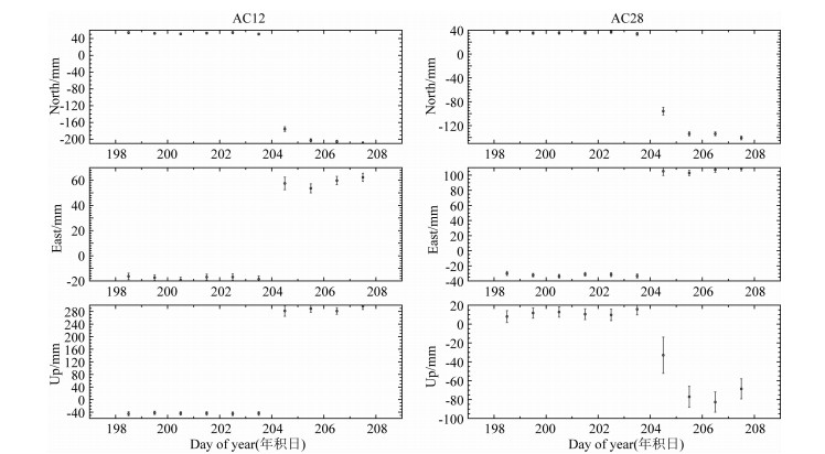
1 GPS资料及处理美国在阿拉斯加半岛布设的CORS台站(Continuously Operating Reference Stations)为我们提供了数据基础.我们选择了离震中300 km以内的14个GPS台站(https://www.ngs.noaa.gov/CORS_Map/),每个台站包括震前6天、震后4天的数据来计算同震位移.我们利用了GAMIT/GLOBK软件(Herring et al., 2015),同时选取了区域周边6个IGS台站(FAIR、HOLB、INVI、UTQI、WHIT、YELL)一起进行解算,各类所需星历表与信息均由IGS服务中心获取,采用IGR快速精密星历(SP3格式)定轨,卫星截止高度角15°,所有GPS流动站的坐标约束为100 m,IGS台站约束为0.01~0.05 m.结果显示,有8个GPS台站(AB07、AB13、AC12、AC13、AC21、AC25、AC28、AC40)有比较明显的同震位移,因此我们选用了这8个台站的数据参与接下来的计算.时间序列如图 2所示.
|
图 2 GPS台站时间序列图 GPS解算得到的北、东、南方向的时间序列图,以AC12、AC28两个台站为例. Fig. 2 Time series of GPS stations The time series of north, east and south directions obtained by GPS solution. Take AC12 and AC28 as examples. |
在基于有限断层模型进行求解时,首先需要通过剪切位错点源模型反演获得震源机制解(姚振兴和纪晨,1997;郝金来等,2011;王卫民等,2013;Wang et al., 2018).震源机制解反演需求解震源深度、滑动角、节面走向、倾角与时间函数.根据反演得到的两个节平面,结合当地的地质构造背景,确定震源破裂面的走向.
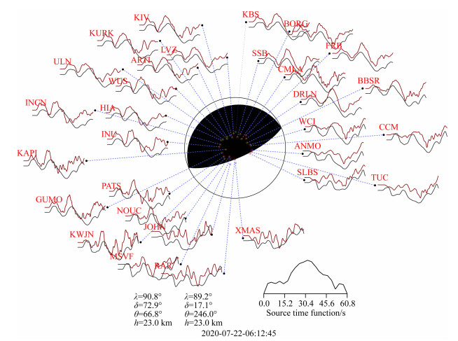
地震发生后,从国际地震学联合会地震数据中心下载了地震波形记录,采用USGS公布的震中位置,来研究地震震源机制和震源破裂过程.我们选择了信噪比较高且方位角覆盖比较均匀的30个远场(震中距范围为30°<Δ<90°)P波垂向波形记录进行反演.波形资料经过去均值、去倾斜等预处理后,根据每条记录的信噪比只进行高通滤波,参与反演的记录长度和采样间隔决定了实际资料频带通常在0.01~5 Hz.反演得到节面1的走向67°,倾角73°,滑动角91°;节面2的走向246°,倾角17°,滑动角89°(图 3).前人研究表明,该处为低角度逆冲构造(Hudnut and Taber, 1987),因此我们判定节面2为断层破裂面.点源模型确定的震源深度为23 km,阿拉斯加地震为一逆冲型地震.震源机制反演计算的理论地震图与观测波形资料进行拟合,波形相关性较好.地震发生后,不同研究机构迅速给出了各自的反演结果(表 1).由于USGS给出的震源机制解是使用W-phase获得的结果,而W-phase是一种长周期的震相,与Harvard CMT、IPGP以及本文使用的主要震相(P,SH)不同,因此本文反演获得的震源机制解更接近Harvard CMT和IPGP的结果,而与USGS的结果存在较大的差异.
|
图 3 2020年M7.8阿拉斯加地震震源机制解 采用下半球投影,同时给出了点源模型的P波垂向位移理论图(黑线)与资料(红线)的拟合情况.图形下方给出了两组节面解(左下,λ,δ,θ,h分别表示断层滑动角、断层倾角、断层走向、震源深度)和点源模型的震源时间函数(右下). Fig. 3 Focal mechanism of 2020 M7.8 Alaska earthquake Lower hemisphere projection is used here. The observed P wave records (black line) and synthetic seismogram (red line) based on the simple point model are compared. The parameters of two possible fault planes are listed also, with λ, δ, θ, h indicating the rake angle, dip angle, strike direction and source depth respectively. The obtained source time function are plotted. |
|
|
表 1 不同机构的震源及断层参数 Table 1 Source and fault parameter from different research group |
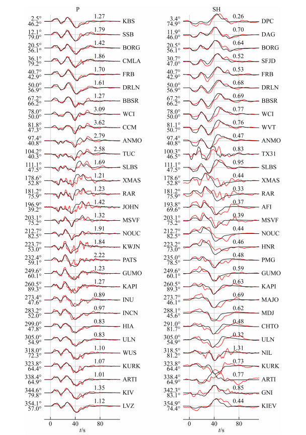
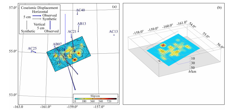
根据有限断层反演方法(王卫民等, 2005, 2008;Wang et al., 2018),结合点源模型的反演结果,断层面的走向为246°,倾角为17.1°,结合此次地震发震后的余震分布情况,选用一条沿走向长200 km,沿倾向宽114 km的断层面,并将其剖分成8 km×6 km的475个子断层来模拟破裂面上滑动的时空分布.使用了30个P波和30个SH波数据,联合近场的8个GPS同震位移记录,来反演得到断层面上滑动分布.同震位移响应的计算采用基于分层介质模型的广义反射透射系数矩阵方法(谢小碧和姚振兴,1989),震源区地壳结构模型获取自Crust2.0(Bassin et al., 2000).反演使用非线性最优化的模拟退火技术,目标函数由采用波形相关系数与同震位移矢量差的归一化加权叠加来定义.反演中根据介质的S波速度给定破裂速度变化范围2.1~3.0 km·s-1,参考波形资料的频谱,给定破裂上升时间变化范围为2.0~10.0 s.在反演中将波形拟合与GPS拟合的目标函数以及模型光滑度参数归一化后给定不同权重进行试算,选取使资料拟合目标函数和模型光滑度同时达到极小的一组权重参数的反演结果作为最优解.如图 4所示为根据有限断层模型计算的理论地震图和观测波形数据的拟合结果,波形的主体部分相关性较好.图 5为联合反演获得的阿拉斯加地震的断层滑动分布.图 5a为破裂滑动在地表的投影和GPS资料的拟合情况,可以看到GPS资料有比较好的拟合.图 5b为滑动分布的三维示意图,显示破裂方向大体为西南方向,断层面破裂滑动分布比较分散,最大滑动量为914 cm,标量地震矩M0=6.94×10²⁰N·m,换算为矩震级MW7.83(Kanamori, 1977).
|
图 4 有限断层模型获得的远场P波和SH波波形拟合结果 红线为实际观测数据,黑线为位移的理论地震图,并给出了每个记录的方位角(左上),震中距(左下),振幅比(上方)以及台站的名称(右). Fig. 4 The fitting results of the observed far field P and SH waveforms and the synthetic waveforms obtained by finite fault model The red line indicates the observed record, and the black line indicates the synthetic seismogram, the azimuth, epicentral distance, amplitude ration and station are also plotted. |
|
图 5 阿拉斯加地震断层滑动分布投影和三维示意图 (a)断层滑动分布地表投影及GPS资料拟合情况.等值线代表自发震起的破裂时刻,箭头和短柱分别表示GPS同震位移的水平分量和垂直分量(深蓝色为观测值, 灰色为理论值); (b)有限断层滑动分布三维示意图. Fig. 5 Alaskan seismic fault slip distribution projections and 3-D representations (a) Surface projection of fault slip distribution and GPS data fitting. The contour line represents the moment of spontaneous rupture, arrows and short columns represent the horizontal and vertical components of GPS co-seismic displacement respectively (dark blue is the observed value and gray is the theoretical value). (b) Three-dimensional diagram of finite fault slip distribution. |
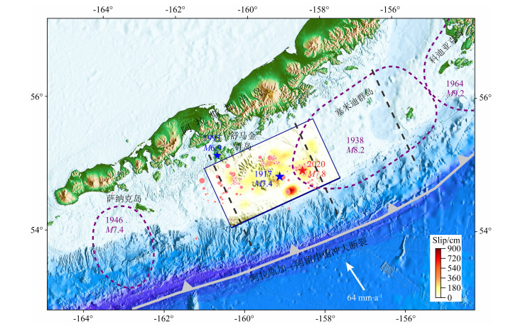
舒马金空区能不能发生M8的特大地震,一直是个有争议的话题(Fournier and Freymueller, 2007; Jacob, 1984; Nishenko and Jacob, 1990).一些研究认为舒马金空区的地震复发周期为65年,现如今积累的应变以使得断裂接近破裂极限,因此地震危险性很高(Jacob, 1984; Li and Freymueller, 2018; Nishenko and Jacob, 1990).另一些则主要基于大地测量方法,认为舒马金空区主要以蠕滑为主,闭锁程度很低(Fournier and Freymueller, 2007; Freymueller et al., 2008),板块运动累积的能量绝大部分缓慢释放,剩余的部分则以每40年发生一次M7左右的地震来释放,弥补了全部的滑动亏损,因此不具备发生M8地震的能力(Fournier and Freymueller, 2007; Freymueller and Beavan, 1999; Savage and Lisowski, 1986; Savage et al., 1986).前人以1917年M7.4地震作为特征地震,研究了空区的地震危险性(Zheng et al., 1996).利用地震矩公式M0=μDA,选择μ为3×10¹⁰Pa,破裂面积为8400 km2,在汇聚速率为63 mm·a-1,断层闭锁程度为20%时,70年的时间可以积累能量为2.1×10²⁰N·m(Zheng et al., 1996).我们据此计算,到2020年共103年累积的能量为3.1×10²⁰N·m,这与2020年M7.8地震矩有着不小的差距.然而,前人研究发现,1917年的地震可能是一个M7.8或M7.9的地震(Abe and Noguchi, 1983; Boyd and Lerner-Lam, 1988; Duda, 1965),震源机制(走向254°,倾角25°,滑动角90°;图 1)也与2020年地震类似,发震位置也比较接近(Estabrook and Boyd, 1992).这可能说明,Zheng等(1996)在计算地震矩时,选用的断层破裂面积偏小.如图 6所示,2020年地震破裂了舒马金东段.GPS结果显示舒马金东段的闭锁程度为30%(Cross and Freymueller, 2008; Fournier and Freymueller, 2007).如果我们用本次地震的破裂面积22800 km2,闭锁程度为30%来计算,除去1993年M6.9地震的释放,从1917年至2020年累积的地震矩为1.3×10²¹N·m,相当于MW8地震.由于现如今舒马金及周边区域闭锁程度的状态,并不是一个瞬时的过程,而已经有超过3400年的历史(Witter et al., 2014).因此,我们认为,至少在舒马金地震空区的东段,有能力产生M8的地震.前人研究发现,舒马金空区曾经在1788年和1847年,以及1917年的大地震中发生了破裂(Davies et al., 1981; Estabrook and Boyd, 1992; Nishenko and Jacob, 1990),据此推断该区域大地震的平均复发间隔约为65年(Boyd and Lerner-Lam, 1988; Boyd et al., 1988; Nishenko and Jacob, 1990).如果再加上2020年的大地震,我们可以估计舒马金东段的大地震平均复发时间约为77年.
|
图 6 阿拉斯加历史地震破裂范围 矩形区域为2020年M7.8级阿拉斯加地震的破裂分布,棕色虚线范围为1938年M8.2、1946年M7.4和1964年M9.2地震破裂分布.红色圆圈代表本次地震的余震.两个蓝色五角星为1917年M7.4和1993年M6.9地震.3条黑色的虚线为区域闭锁程度的分界线,科迪亚克区域为强闭锁,塞米迪为中等闭锁,舒马金东段为弱闭锁,舒马金西段到萨纳克区域基本处于不闭锁状态(Li and Freymueller, 2018). Fig. 6 Rupture range of historical earthquakes in Alaska The rectangular area is the rupture distribution of the 2020 M7.8 Alaska earthquake, and the brown dotted line range is the rupture distribution of the 1938 M8.2, 1946 M7.4 and 1964 M9.2 earthquakes. The red circles represent aftershocks of 2020 M7.8 earthquake. Two blue stars are M7.4 in 1917 and M6.9 in 1993. Three black dotted lines are the dividing line of regional locking ratio. Kodiak region is strong locking, Semidi is medium locking, Shumagin east section is weak locking, and Shumagin west section to Sanak area is basically not locked(Li and Freymueller, 2018). |
Hudnut和Taber(1987)认为,在舒马金空区西段,有双贝尼奥夫带,处于闭锁状态,有能力发生MS8地震;东部则处于自由滑动状态.而另一些研究者则持相反的结论(Fournier and Freymueller, 2007; Li and Freymueller, 2018).我们的反演结果表明,本次地震并没有破裂到舒马金西段(图 6).事实上,1788年和1847年的地震,包括1917年的地震,可能也只是破裂了舒马金空区东段(Davies et al., 1981; Sykes et al., 1980).舒马金西段长期大地震缺失,可能说明该部分不容易累积应变能.因此我们支持舒马金东部部分闭锁,西部几乎自由滑动的观点.这说明东部和西部地震危险性,以及可能发生地震的最大震级也有差异.这种差异性可能意味着舒马金东段和西段有着不同的地震复发间隔,或者两者正处于不同的地震周期阶段.
5 结论通过远场地震波形和近场GPS数据,采用有限断层反演方法,获得了2020年阿拉斯加地震的震源破裂过程.结果表明该地震为震级MW7.8,震源深度23 km,断层倾角为17°的低角度逆冲型地震.断层面破裂滑动分布比较分散,最大滑动量为914 cm.地震震中位于舒马金地震空区东缘,破裂大体向西南方向传播,破裂了空区的东段.太平洋板块向北美板块的俯冲,是该地震的主要成因.
结合板块之间的汇聚速率,以及舒马金区域的闭锁程度,通过计算舒马金区域长期以来的累积地震矩,我们认为至少在舒马金空区的东部,有能力产生M8的特大地震.空区的西段可能有着与东段不同的地震复发周期,能产生的最大震级也有差异,两者可能正处于不同的地震周期阶段.
致谢 远场波形资料由IRIS提供,本文图件由GMT软件生成,在此一并致谢,并感谢本文引用文献的研究者.
Abe K, Noguchi S. 1983. Determination of magnitude for large shallow earthquakes 1898-1917. Physics of the Earth and Planetary Interiors, 32(1): 45-59. DOI:10.1016/0031-9201(83)90077-8 |
Bassin C, Laske G, Masters G. 2000. The current limits of resolution for surface wave tomography in North America. Eos Trans. AGU, 81: F897. |
Boyd T M, Lerner-Lam A L. 1988. Spatial distribution of turn-of-the-century seismicity along the Alaska-Aleutian arc. Bulletin of the Seismological Society of America, 78: 636-650. |
Boyd T M, Taber J J, Lerner-Lam A L, et al. 1988. Seismic rupture and arc segmentation within the Shumagin Islands seismic gap, Alaska. Geophysical Research Letters, 15(3): 201-204. DOI:10.1029/GL015i003p00201 |
Bufe C G, Nishenko S P, Varnes D J. 1994. Seismicity trends and potential for large earthquakes in the Alaska-Aleutian region. Pure and Applied Geophysics, 142(1): 83-99. DOI:10.1007/BF00875969 |
Butler R. 2012. Re-examination of the potential for great earthquakes along the Aleutian Island Arc with implications for tsunamis in Hawaii. Seismological Research Letters, 83(1): 29-38. DOI:10.1785/gssrl.83.1.29 |
Cross R S, Freymueller J T. 2008. Evidence for and implications of a Bering plate based on geodetic measurements from the Aleutians and western Alaska. Journal of Geophysical Research:Solid Earth, 113: B07405. DOI:10.1029/2007JB005136 |
Davies J, Sykes L, House L, et al. 1981. Shumagin seismic gap, Alaska Peninsula:History of great earthquakes, tectonic setting, and evidence for high seismic potential. Journal of Geophysical Research:Solid Earth, 86(B5): 3821-3855. DOI:10.1029/JB086iB05p03821 |
Duda S J. 1965. Secular seismic energy release in the circum-Pacific belt. Tectonophysics, 2(5): 409-452. DOI:10.1016/0040-1951(65)90035-1 |
Estabrook C H, Boyd T M. 1992. The Shumagin Islands, Alaska, earthquake of 31 May 1917. Bulletin of the Seismological Society of America, 82: 755-773. |
Fletcher H J, Beavan J, Freymueller J, et al. 2001. High interseismic coupling of the Alaska subduction zone SW of Kodiak island inferred from GPS data. Geophysical Research Letters, 28(3): 443-446. DOI:10.1029/2000GL012258 |
Fournier T J, Freymueller J T. 2007. Transition from locked to creeping subduction in the Shumagin region, Alaska. Geophysical Research Letters, 34(6): L06303. DOI:10.1029/2006GL029073 |
Freymueller J T, Beavan J. 1999. Absence of strain accumulation in the western Shumagin segment of the Alaska subduction zone. Geophysical Research Letters, 26(21): 3233-3236. DOI:10.1029/1999GL008356 |
Freymueller J T, Woodard H, Cohen S C, et al. 2008. Active deformation processes in Alaska, based on 15 years of GPS measurements.//Freymueller J T, Haeussler P J, Wesson R L, et al. eds. Active Tectonics and Seismic Potential of Alaska. Washington: American Geophysical Union, 179: 1-42.
|
Hao J L, Wang W M, Yao Z X. 2011. Source process of the 2011 MW9.0 Tohuko Japan earthquake. Science China Earth Sciences, 54(8): 1105-1109. DOI:10.1007/s11430-011-4241-y |
Hauksson E, Armbruster J, Dobbs S. 1984. Seismicity patterns (1963-1983) as stress indicators in the Shumagin seismic gap, Alaska. Bulletin of the Seismological Society of America, 74(6): 2541-2558. |
Herring T A, King R W, McClusky S C. 2015. Introduction to GAMIT/GLOBK, Release 10.6. Cambridge: Massachusetts Institute of Technology.
|
Hudnut K W, Taber J J. 1987. Transition from double to single Wadati-Benioff seismic zone in the Shumagin Islands, Alaska. Geophysical Research Letters, 14(2): 143-146. DOI:10.1029/GL014i002p00143 |
Jacob K H. 1984. Estimates of long-term probabilities for future great earthquakes in the Aleutians. Geophysical Research Letters, 11(4): 295-298. DOI:10.1029/GL011i004p00295 |
Kanamori H. 1977. The energy release in great earthquakes. Journal of Geophysical Research, 82(20): 2981-2987. DOI:10.1029/JB082i020p02981 |
Kelleher J A. 1970. Space-time seismicity of the Alaska-Aleutian Seismic Zone. Journal of Geophysical Research, 75(29): 5745-5756. DOI:10.1029/JB075i029p05745 |
Larson K M, Lisowski M. 1994. Strain accumulation in the Shumagin Islands:results of initial GPS measurements. Geophysical Research Letters, 21(6): 489-492. DOI:10.1029/94GL00417 |
Li S S, Freymueller J T. 2018. Spatial variation of slip behavior beneath the Alaska Peninsula along Alaska-Aleutian subduction zone. Geophysical Research Letters, 45(8): 3453-3460. DOI:10.1002/2017GL076761 |
Lisowski M, Savage J C, Prescott W H, et al. 1988. Absence of strain accumulation in the Shumagin seismic gap, Alaska, 1980-1987. Journal of Geophysical Research:Solid Earth, 9(B7): 7909-7922. |
McCann W R, Nishenko S P, Sykes L R, et al. 1979. Seismic gaps and plate tectonics:Seismic potential for major boundaries. Pure & Applied Geophysics, 117(6): 1082-1147. |
Minster J B, Jordan T H. 1978. Present-day plate motions. Journal of Geophysical Research:Solid Earth, 83(B11): 5331-5354. DOI:10.1029/JB083iB11p05331 |
Nishenko S P, Jacob K H. 1990. Seismic potential of the Queen Charlotte-Alaska-Aleutian seismic zone. Journal of Geophysical Research:Solid Earth, 95(B3): 2511-2532. DOI:10.1029/JB095iB03p02511 |
Savage J C, Lisowski M. 1986. Strain accumulation in the Shumagin seismic gap, Alaska. Journal of Geophysical Research:Solid Earth, 91(B7): 7447-7454. DOI:10.1029/JB091iB07p07447 |
Savage J C, Lisowski M, Prescott W H. 1986. Strain accumulation in the Shumagin and Yakataga seismic gaps, Alaska. Science, 231(4738): 585-587. DOI:10.1126/science.231.4738.585 |
Sykes L R, Kisslinger J B, House L, et al. 1980. Rupture zones of great earthquakes in the Alaska-Aleutian arc, 1784 to 1980. Science, 210(4476): 1343-1345. DOI:10.1126/science.210.4476.1343 |
Sykes L R, Kisslinger J B, House L, et al. 1981. Rupture zones and repeat times of great earthquakes along the Alaska-Aleutian ARC, 1784-1980.//Simpson D W, Richards P G eds. Earthquake Prediction: An International Review. Washington, DC: American Geophysical Union, 4: 73-80.
|
Wang W M, Zhao L F, Li J, et al. 2005. Rupture process of the Chi-Chi (Taiwan) earthquake in 1999. Chinese Journal of Geophysics (in Chinese), 48(1): 132-147. DOI:10.3321/j.issn:0001-5733.2005.01.019 |
Wang W M, Zhao L F, Li J, et al. 2008. Rupture process of the Ms 8.0 Wenchuan earthquake of Sichuan, China. Chinese Journal of Geophysics (in Chinese), 51(5): 1403-1410. DOI:10.3321/j.issn:0001-5733.2008.05.013 |
Wang W M, Hao J L, Yao Z X. 2013. Preliminary result for rupture process of Apr. 20, 2013, Lushan earthquake, Sichuan, China. Chinese Journal of Geophysics (in Chinese), 56(4): 1412-1417. DOI:10.6038/cjg20130436 |
Wang W M, Hao J L, Yao Z X. 2018. Preliminary results for the rupture process of Jan. 10, 2018, MW7.6 earthquake at east of Great Swan Island, Honduras. Earth Planet. Phys., 2: 86-87. DOI:10.26464/epp2018010 |
Wang W M, He J K, Hao J L, et al. 2018. Preliminary result for the rupture process of Nov.13, 2017, MW7.3 earthquake at Iran-Iraq border. Earth Planet. Phys., 2: 82-83. DOI:10.26464/epp2018008 |
Witter R C, Briggs R W, Engelhart S E, et al. 2014. Little late Holocene strain accumulation and release on the Aleutian megathrust below the Shumagin Islands, Alaska. Geophysical Research Letters, 41(7): 2359-2367. DOI:10.1002/2014GL059393 |
Xie X B, Yao Z X. 1989. A generalized reflection-transmition coefficient matrix method to calculate static displacement field of a stratified half-space by dislocation source. Acta Geophysica Sinica (in Chinese), 32(3): 270-280. |
Yao Z X, Ji C. 1997. The inverse problem of finite fault study in time domain. Acta Geophysica Sinica (in Chinese), 40(5): 691-701. |
Zheng G T, Dmowska R, Rice J R. 1996. Modeling earthquake cycles in the Shumagin subduction segment, Alaska, with seismic and geodetic constraints. Journal of Geophysical Research:Solid Earth, 101(B4): 8383-8392. DOI:10.1029/95JB03461 |
郝金来, 王卫民, 姚振兴. 2011. 2011年3月11日日本东北沿海MW9.0级地震震源破裂过程. 中国科学:地球科学, 41(6): 745-749. |
王卫民, 赵连锋, 李娟, 等. 2005. 1999年台湾集集地震震源破裂过程. 地球物理学报, 48(1): 132-147. DOI:10.3321/j.issn:0001-5733.2005.01.019 |
王卫民, 赵连锋, 李娟, 等. 2008. 四川汶川8.0级地震震源过程. 地球物理学报, 51(5): 1403-1410. DOI:10.3321/j.issn:0001-5733.2008.05.013 |
王卫民, 郝金来, 姚振兴. 2013. 2013年4月20日四川芦山地震震源破裂过程反演初步结果. 地球物理学报, 56(4): 1412-1417. DOI:10.6038/cjg20130436 |
谢小碧, 姚振兴. 1989. 计算分层介质中位错点源静态位移场的广义反射、透射系数矩阵和离散波数方法. 地球物理学报, 32(3): 270-280. DOI:10.3321/j.issn:0001-5733.1989.03.004 |
姚振兴, 纪晨. 1997. 时间域内有限地震断层的反演问题. 地球物理学报, 40(5): 691-701. DOI:10.3321/j.issn:0001-5733.1997.05.010 |
 2021, Vol. 64


