2. 成都理工大学地球物理学院, 成都 610059;
3. 四川省地震局, 成都 610041
2. College of Geophysics, Chengdu University of Technology, Chengdu 610059, China;
3. Sichuan Earthquake Agency, Chengdu 610041, China
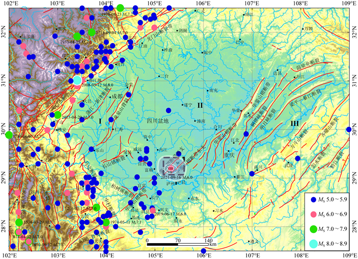
据中国地震台网测定,2021年9月16日4时33分31.7秒,四川省泸州市泸县发生MS6.0地震(图 1),初始定位震中位于105.34°E、29.2°N,震源深度10 km.本次地震是继2019年6月17日长宁MS6.0地震后在四川盆地发生的又一次6级强震,也打破了泸州地区无6级地震的历史记录.

|
图 1 泸县6.0级地震震中附近区域构造与5级以上历史地震分布 图 1中黑色虚线框标示图 4的范围;带白边的灰色影区代表等震线分布;Ⅰ—盆西平原区;Ⅱ—盆中丘陵区;Ⅲ—盆东山地区. Fig. 1 Regional tectonic settings and the epicenters of the MS≥5.0 historical earthquakes since 26 BC around the epicenter of the MS6.0 Luxian event Dashed black rectangle marks the region in Fig. 4. Gray-shaded area with white edge outlines the isoseismal map of the MS6.0 Luxian event. Ⅰ—Western basin plain; Ⅱ—Central basin hilly area; Ⅲ—Eastern basin mountain area. |
泸县MS6.0地震发生后,四川省地震局迅速启动地震二级应急响应,即刻成立现场工作组赶赴震区.根据工作组现场调查,本次地震等震线(图 1中带白边的灰色影区)长轴呈NWW走向,长轴约62 km,短轴约54 km,Ⅵ度及以上区域面积为2613 km2,其中极震区烈度达Ⅷ度,包括泸州市泸县福集镇、玉蟾街道、嘉明镇和内江市隆昌市云顶镇(四川省地震局,2021),共造成3人死亡,159人受伤.
泸县MS6.0地震震中位于区域地震台网监测能力相对较好的地区,距离震中最近的固定测震台站为重庆ROC台和四川LZH台,震中距分别约22 km、37 km(图 2), 可保证ML1.0以上地震记录完整.至2021年9月23日,四川台网共观测到本次6.0级地震的余震159次,以ML2.0以下余震为主,其中:ML0.0-0.9级96次,ML1.0-1.9级44次;ML2.0-2.9级15次;ML3.0-3.9级4次,最大余震为9月16日4时55分19秒MS2.8(ML3.4)地震(图 3). 与发生在四川盆地边缘的2019年长宁MS6.0地震同时段余震序列相比(易桂喜等,2019),无论是余震频次还是余震强度都明显偏低.本次MS6.0地震的最大余震与主震震级差达3.2,且主震释放的能量EM与整个序列释放能量E总的比值达99.99%,显示该地震序列为孤立型(蒋海昆等,2006).主震前9 h内主震震中附近存在少量前震活动,最大前震震级为ML3.5(图 3),表明泸县MS6.0地震序列属于有前震活动的孤立型地震序列.

|
图 2 泸县MS6.0地震震中附近四川及邻区固定测震台站分布 红色五星为泸县MS6.0地震震中;绿色圆点代表2020年以来本次MS6.0地震震中附近沿华蓥山褶断带的3次中小地震;蓝色三角形代表固定台站;实线圆标示主震震中距300 km范围. Fig. 2 Distribution of permanent seismic stations around the MS6.0 Luxian earthquake Red star marks the epicenter of the MS6.0 Luxian event. Green dots represent three small to moderate events along Huayingshan fold-thrust belt since 2020. Blue triangles indicate permanent stations. And solid-line circle indicates the range with epicentral distance of 300 km. |

|
图 3 泸县MS6.0地震序列ML≥0.0事件M-T图(2021-09-15—09-23) Fig. 3 Plot of magnitude (M) of the ML≥0.0 events with respect to time (T) for the MS6.0 Luxian earthquake sequence from September 15 to 23, 2021 |
泸县MS6.0地震发生在四川盆地历史弱震区(国家地震局震害防御司,1995;汪素云,1999),震源区域地震相关构造研究成果甚少.鉴于本次地震余震不丰富且震级偏低,本文拟采用绝对定位方法,利用HYPO2000(Klein, 1989)对序列中ML1.0以上地震事件进行重新定位;利用Cut and Paste(简称CAP)方法(Zhao and Helmberger, 1994;Zhu and Helmberger, 1996),通过波形反演获取本次MS6.0地震的矩震级、震源矩心深度和震源机制解;进而采用面应变As(Vallage et al., 2014)和应变花方法(Amelung and King, 1997),分析和探讨本次地震的序列特征和孕震构造环境.
1 泸县MS6.0地震构造背景及历史地震概况泸县MS6.0地震发生在四川盆地东南部(图 1).四川盆地地表构造形迹受周边大型构造带活动影响,形成多期多组构造叠合样式,以龙泉山和华蓥山为界,在地貌上呈现三分特点(刘树根等,2011;叶玥豪,2018):乐山—龙泉山一线以西至龙门山前缘的区域(图 1中的Ⅰ区)为盆西平原地貌,主体构造NE向,受龙门山冲断活动控制;乐山—龙泉山一线以东至宜宾—华蓥山一线(Ⅱ区)属盆中丘陵地貌,地表构造相对平缓,以NE向和NW向构造的复合叠加为特征;宜宾-华蓥山一线以东至齐曜山断裂间(Ⅲ区)为盆东山地地貌,以发育NE至NNE向平行相间排列的狭窄背斜和宽缓向斜为典型特征(邓宾,2013).泸县MS6.0地震发生在宜宾—华蓥山一线的华蓥山褶断带(张岳桥等,2011)内(图 1),该褶断带北起达县北,南至宜宾南,全长约460 km,为一条断错结晶基底的大断裂,第四纪以来具有一定的活动性,总体走向N30°~45°E、倾向SE,倾角30°~70°之间,呈挤压逆冲性质,兼具一定的右旋走滑分量,地表断裂主要发育在背斜的轴部或其陡翼,由一系列长数km至数十km的断裂斜列或平行展布而成,并大致以合川、邻水为界,分为北东段、中段、南西段(周荣军等,1997).本次MS6.0地震的微观震中处于华蓥山褶断带南西段,在震中附近该段分为东、西两支(图 1),分别由多条次级断层组成,主要呈逆冲性质,中间为喻家寺向斜.四川区域地震台网给出的本次地震初始定位震中(105.333°E、29.2°N)距西支断层约3.4 km,距东支断层约8.0 km.
根据历史地震记载,华蓥山褶断带地震活动强度一直低于6级(国家地震局震害防御司,1995;汪素云,1999),仅有数次5级以上破坏性地震(图 1),中强地震频度低、复发周期长.此次泸县MS6.0地震因此也刷新了华蓥山褶断带的强震记录.
2 序列地震重新定位本次泸县6.0级地震余震少且震级小,序列不发育(图 3).为了获得更为准确的震源位置,我们采用HYPO2000(Klein,1989)和邻近的长宁区域一维速度模型(易桂喜等,2019)(表 1),对MS6.0主震及9月15—22日序列中ML≥1.0前震和早期余震进行重新定位.最终获得重新定位后的主震震源参数为:发震时刻2021-09-16 04 ∶ 33 ∶ 31.83,震中位于105.364°E、29.218°N,震源初始破裂深度5.1 km,水平误差0.7 km,垂直误差1.1 km,走时残差0.18 s. ML3.4最大余震的重新定位震源参数为:发震时刻2021-09-16 04 ∶ 55 ∶ 19.79,震中位于105.362°E、29.182°N,震源深度4.2 km,水平误差0.7 km,垂直误差2.3 km,走时残差0.22 s.ML3.5最大前震的重新定位震源参数为:发震时刻2021-09-15 20 ∶ 32 ∶ 17.92,震中位于105.350°E、29.220°N,震源深度7.3 km,水平误差0.5 km,垂直误差0.99 km,走时残差0.25 s.最大前震深度略大于主震和最大余震深度.
|
|
表 1 长宁地区一维速度模型(易桂喜等,2019) Table 1 1-D velocity model in Changning area (Yi et al., 2019) |
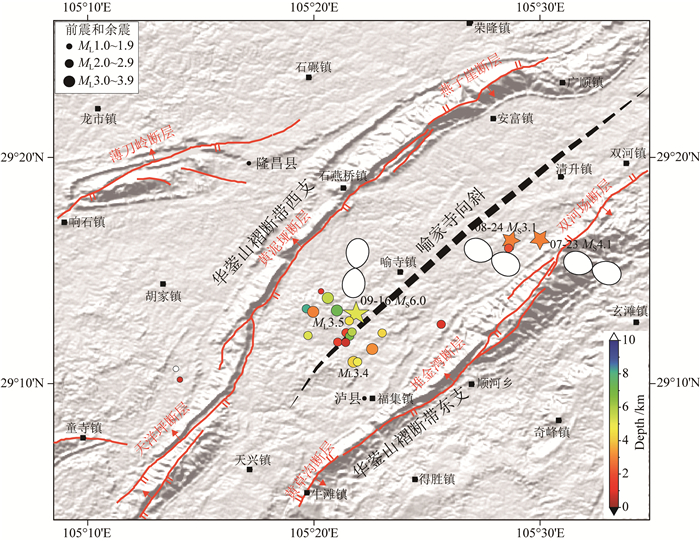
ML2.0以上前震和早期余震相对集中区范围较小,总体优势分布方向呈NWW向,长轴仅约6 km,且与华蓥山褶断带走向近似垂直(图 4).最大前震与主震震中距约1.5 km,同位于喻家寺向斜的北西翼;最大余震距离主震约4.0 km,位于喻家寺向斜的南东翼(图 4),应属于主震触发南东翼的构造活动所致.

|
图 4 序列重新定位地震分布与7月23日泸县MS4.1、8月24日泸县MS3.1和9月16日泸县MS6.0地震应变花样彩色圆点代表MS6.0地震序列中重新定位的地震震中. Fig. 4 Relocated earthquakes in the MS6.0 Luxian sequence and strain rosettes of the MS4.1 Luxian event on July 23, MS3.1 Luxian event on August 24 and MS6.0 Luxian mainshock on September 16 The colour dots mark the relocated epicenters of the MS6.0 earthquake sequence. |
利用表 1的速度模型,我们选取四川和邻省区域地震台网中位于泸县MS6.0地震震中300 km范围内的宽频带固定台站(图 2)高信噪比波形资料,采用CAP波形反演方法,同时获取本次泸县MS6.0地震的矩震级、震源矩心深度和震源机制解等结果.
CAP方法对速度模型依赖性较小(Tan et al., 2006;郑勇等, 2009;吕坚等,2013;龙锋等,2021),保证了震源机制解计算结果的可靠性.同时,在波形反演过程中,该方法利用了体波与面波的相对强度进行深度约束,获取的震源矩心深度则更为准确(luo et al., 2015),为发震构造判定和孕震环境分析提供可信的支撑依据(易桂喜等, 2019, 2020).
为了分析本次MS6.0地震及震中附近区域的发震构造特征,本文同时还计算了分别位于该地震震中南西侧约38 km的2020年1月1日富顺MS4.3、位于北东侧约13 km的2021年7月23日泸县MS4.1和8月24日MS3.1(ML3.7)3次地震的震源机制解和震源矩心深度,震中分布见图 2.计算时,泸县MS6.0地震与另外3次中小地震(富顺MS4.3、泸县MS4.1和MS3.1)的震源函数持续时间分别设置为5 s、1 s;体波与面波截取波形窗长分别为30 s和60 s,对应的滤波频带分别为0.05~0.2 Hz、0.05~0.1 Hz;断层面参数搜索步长为5°;深度搜索步长为0.5 km.计算结果见表 2.
|
|
表 2 泸县MS6.0地震和震中附近2020年以来沿华蓥山褶断带的3次中小地震震源机制解 Table 2 Focal mechanism solutions of the MS6.0 Luxian earthquake and another three small-moderate events along Huayingshan fold-thrust belt since 2020 |
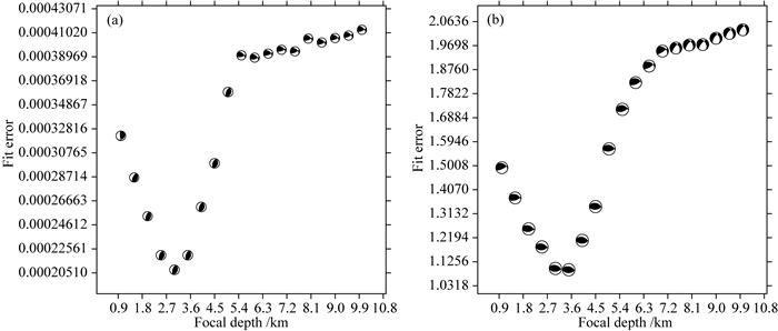
图 5分别给出了泸县MS4.1和MS6.0地震波形反演误差随深度的变化,其中,泸县MS6.0地震最佳波形拟合深度为3.5 km(图 5b),与重新定位后的初始破裂深度(5.1 km)相近,两者差异小于2 km.图 6和图 7为泸县MS4.1和MS6.0地震最佳拟合深度处观测波形与理论波形拟合图,可以看出,除个别分量外,MS6.0地震实际观测波形与合成理论波形拟合较好,大多数分量的拟合相关系数大于80%(图 7).

|
图 5 2021年7月23日泸县MS4.1和9月16日泸县MS6.0地震震源机制解波形反演残差随深度的变化 (a) 7月23日泸县MS4.1地震;(b) 9月16日泸县MS6.0地震. Fig. 5 Variation of fitting error with depth during the focal mechanism inversion for the MS4.1 and MS6.0 Luxian earthquake on July 23 and September 16, 2021, respectively (a) MS4.1 Luxian earthquake on July 23; (b) MS6.0 Luxian earthquake on September 16. |

|
图 6 2021年7月23日泸县MS4.1地震最佳拟合深度3.0 km处的波形拟合 黑线和红线分别代表观测波形和理论波形.左侧的英文字母代表台站名,其上部和下部数字分别为震中距(km)和方位角(°);位于波形下方的第一行数字为理论波形相对观测波形的移动时间(s),第二行数字代表观测波形和理论波形之间的拟合相关系数(%). Fig. 6 Waveform fitting between the observed and synthetic ones at the best-fitting depth 3.0 km of the MS4.1 Luxian earthquake on July 23, 2021 The black and red lines mark the observed and synthetic waveforms. The letters on the left represent station names. The numbers above and below the names are epicentral distance in km and azimuth in degree, while the numbers below the waveforms are the time shifts in second of the synthetics relative to the observed in the first lines, and cross-correlation coefficients in percentage in the second lines. |

|
图 7 2021年9月16日泸县MS6.0地震最佳拟合深度3.5 km处的波形拟合 黑线和红线分别代表观测波形和理论波形.左侧的英文字母代表台站名,其上部和下部数字分别为震中距(km)和方位角(°);位于波形下方的第一行数字为理论波形相对观测波形的移动时间(s),第二行数字代表观测波形和理论波形之间的拟合相关系数(%). Fig. 7 Waveform fitting between the observed and synthetic ones at the best-fitting depth 3.5 km of the MS6.0 Luxian earthquake on September 16, 2021 The black and red lines mark the observed and synthetic waveforms. The letters on the left represent station names. The numbers above and below the names are epicentral distance in km and azimuth in degree, while the numbers below the waveforms are the time shifts in second of the synthetics relative to the observed in the first lines, and cross- correlation coefficients in percentage in the second lines. |
CAP波形反演获得的本次泸县MS6.0地震的矩震级为MW5.36,远低于其面波震级,也明显低于发生在邻近区域的2019年长宁MS6.0地震的矩震级MW5.79.根据Wells和Coppersmith(1994)给出的逆冲型地震矩震级MW与震源破裂长度L的经验关系:MW=4.49+1.49lgL(±0.26),估算出本次地震的震源破裂尺度L大约4 km,仅为同震级的长宁地震破裂尺度估算值的一半.
震源深度是判定发震构造和发震成因以及建立区域地球动力学模型的关键参数之一(Gomberg et al., 1990; 祁玉萍等,2018;Fang et al., 2018;Long et al., 2019;龙锋等,2021). 由波形反演获得的富顺MS4.3、泸县MS4.1、MS3.1、MS6.0地震的震源矩心深度分别为2.0 km、3.0 km、3.0 km、3.5 km(表 2),明显小于青藏高原东缘其他构造区域的强震震源深度(易桂喜等,2016;赵博等,2019),反映上述地震均发生在四川盆地上地壳浅部沉积盖层内(周荣军等,1997;Li et al., 2018;Long et al., 2020),符合最近3年四川盆地中强地震活动深度普遍较浅的特征(Lei et al., 2019;易桂喜等, 2019, 2020;Long et al., 2020;雷兴林等, 2020; Wong et al., 2021; Yang et al., 2021a; Yang et al., 2021b; Zhao et al., 2021). 波形反演获得的震源矩心深度与利用震相确定的震源深度具有不同的物理意义(吴忠良和牟其铎,1994;高原等,1997),本次MS6.0地震的震源矩心深度与重新定位后的初始破裂深度(5.1 km)较为接近,不仅证实了该地震震源浅,也说明其震源破裂尺度相对较小,这或许可以解释该地震的矩震级与面波震级差超过0.6的原因所在.上述4次地震事件由四川区域地震台网给出的定位深度分别为9 km、22 km、6 km、9 km,远大于本文波形反演的震源矩心深度.区域地震台网给出的上述地震的震源深度应存在较大的误差.
4 泸县MS6.0地震孕震构造环境及后续地震趋势分析本文采用应变花和面应变As值进行震源机制解分类和发震构造运动学特征与震源附近区域的构造变形特征分析(Vallage et al., 2014;Amelung and King, 1997).As值代表应变花的挤压白瓣长度与拉张黑瓣长度之差(Vallage et al., 2014;易桂喜等,2016),对于单个地震,As值在-1与1之间,震源机制分类标准如下:0.7≤As≤1,逆冲型,其中,As=1代表纯挤压逆冲型、应变花样仅有挤压白瓣;0.3≤As<0.7,逆冲兼走滑型;-0.3≤As<0.3,走滑型,其中,As=0代表纯走滑型、应变花样挤压白瓣与拉张黑瓣长度一致;-0.7≤As<-0.3,正断兼走滑型;-1≤As<-0.7,正断型,其中,As=-1代表纯拉张型、应变花样仅有拉张黑瓣.
重新定位后的泸县MS6.0地震震中位于华蓥山褶断带南西段的喻家寺向斜轴部附近(图 4),该段结构复杂,地表断裂分为东、西两支,分别位于向斜的两翼,各包含多条不同几何结构特征的逆冲断裂.由表 2和图 2可以看出,富顺MS4.3、泸县MS4.1、MS3.1和MS6.0地震的震源机制解节面走向及所呈现的发震断层运动学特征均存在明显的分段差异.位于泸县MS6.0地震震中北东侧的泸县MS4.1和MS3.1地震震源机制解一致,节面走向NE,与华蓥山褶断带总体走向一致(图 2),面应变As值均为1.0,显示发震断层纯逆冲.泸县MS6.0地震震源机制解显示两个节面的走向分别为NWW向和近EW向,与华蓥山褶断带NE走向差异甚大(图 2),As值为0.97,表明本次MS6.0地震的发震构造为NWW或近EW向的隐伏逆冲断层.而位于泸县MS6.0地震震中南西侧的富顺MS4.3地震震源机制解节面走向近NS(图 2),As值为0.85,显示该地震的发震构造仍为逆冲型,但具有一定的走滑分量.综合来看,沿华蓥山褶断带自北东向南西,As值逐渐减小,反映该褶断带自北东向南西存在走滑分量逐渐增大的趋势.但总体而言,与南西侧的2019年长宁MS6.0地震序列震源机制解多样性相比(易桂喜等,2019;赵博等,2020),泸县附近区域的地震震源机制错动类型单一,反映所处构造环境相对简单.
统计发现,泸县MS6.0地震主压应力P轴方位与其余3次地震存在明显的差异(表 2).分别位于泸县MS6.0地震震中南西和北东两侧的富顺MS4.3、泸县MS4.1和MS3.1地震尽管震源机制解节面走向不同(图 2),但P轴方位较为接近,也与华蓥山褶断带所处区域构造应力场NW-SE向主压应力方向基本一致(Heidbach et al., 2018;Rui and Stamps, 2019; Wang and Shen, 2020),表明上述中小地震的震源区主要受区域构造应力场控制.而泸县MS6.0地震的震源机制解P轴方位187°、俯仰角1°,显示其震源区主压应力呈近NS向水平推挤特征,主压应力方位与震源所处华南地块区域构造应力场NW-SE向主压应力方向存在显著差异, 反映本次MS6.0地震应受局部应力场控制.
根据泸县MS4.1、MS3.1、MS6.0地震震源机制解获得的应变花样(图 4),北东侧的泸县MS4.1和MS3.1地震震源区构造以NW-SE向纯挤压变形为特征, 泸县MS6.0地震震源区构造则以近NS向纯挤压变形为特征.本次MS6.0地震震中位于华蓥山褶断带西支构造拐折部位附近(图 4),已有研究曾推测该区存在局部应力集中的特征(周荣军等,1997),从现今地貌发育样式看,拐折部位东、西两侧地形差异也反映出不同的挤压缩短变形,同时西支断层左阶排列,略带右旋分量,震中附近区域为褶断带内挤压区,因而,本次地震可以看做是挤压区应力集中释放的一次事件.该地震震源机制解节面走向与西支断裂及附近已知的地表断层几何结构不匹配,结合重新定位的前震和早期余震空间展布近NWW向优势特征(图 4)及等震线长轴走向NWW(图 1),初步判定走向NWW(286°)的节面Ⅰ为同震破裂面,发震断层倾角45°,推测本次泸县MS6.0地震为上地壳浅部沉积盖层内NWW向隐伏逆冲断层在近NS向水平主压应力作用下挤压错动所致.
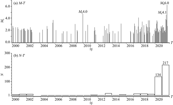
高原等(2018)研究发现,汶川地震之后,川东南地区地壳应力处于增加状态,增大了发生地震的危险性,该前瞻性认识已由最近3年发生的一系列中强地震得以证实.泸县区域属于四川盆地历史少震与弱震区,2000至2019年ML≥1.0地震平均年频次仅6.3次,其间发生的最大地震为2009年11月20日泸县MS4.0地震(图 8a).然而,最近两年该区域地震活动显著上升,2020年ML≥1.0地震年频次突升至134次,2021年在不到9个月的时间内已发生ML≥1.0地震217次(图 8b),其间先后发生2021年7月23日MS4.1和9月16日MS6.0地震,呈现地震频次和震级的同步上升趋势(图 8),泸县MS6.0地震是否属于前述川东南地区地壳应力增加过程的产物?仍需进一步研究.2019年长宁MS6.0地震发生后,易桂喜等(2019)曾提出亟需重新评估四川盆地内部及边缘地带的强震危险性.泸县区域属于未来10年川南页岩气重点开发区,随着工业活动的增加,区域内不同尺度断裂及其应力场可能会遭受扰动导致地震活动加剧(雷兴林等, 2020; Tan et al., 2020;张捷等,2021),因此,有必要对该区域的地震危险性进行重新评估,分析未来地震发生趋势;同时,深入调查四川盆地复杂断裂体系及潜在发震构造,加大地震监测力度,开展该区域地震发震机理研究,为当地防震减灾提供科学依据,以减轻地震灾害风险.

|
图 8 泸县地区2000年以来ML≥1.0地震M-T和年频次N-T图 Fig. 8 Plots of magnitude (M) and annual frequency (N) of the ML≥1.0 earthquakes with respect to time T in Luxian County since 2000 |
本文基于四川台网提供的地震目录和波形记录,初步分析了2021年9月16日泸县MS6.0地震的序列特征;利用HYPO2000对该地震及ML1.0以上前震和早期余震进行了重新定位;并利用CAP波形反演方法,获得了MS6.0地震及沿华蓥山褶断带发生的另外3次中小地震的矩震级、震源矩心深度和震源机制解,对本次泸县MS6.0地震的发震构造环境及后续地震趋势进行了初步分析和讨论.主要认识如下:
(1) 泸县MS6.0地震发生在NE向华蓥山褶断带内部,震前具有少量前震活动,但余震频次低、强度弱,最大余震(MS2.8)与主震震级差3.2,呈现为具有少量前震的孤立型地震序列特征.
(2) 重新定位后的泸县MS6.0主震和ML3.4最大余震的震源初始破裂深度分别为5.1 km、4.2 km.ML2.0以上前震和早期余震相对集中区长轴仅约6 km,总体优势分布呈NWW向,与华蓥山褶断带走向近似垂直.最大前震与主震位于喻家寺向斜的北西翼,最大余震则位于喻家寺向斜的南东翼,应属于主震触发南东翼的构造活动所致.
(3) CAP波形反演获取的泸县MS6.0地震震源机制解节面Ⅰ参数(走向、倾角、滑动角)为286°、45°、103°,节面Ⅱ参数为88°、46°、77°,揭示本次地震为逆冲型,但节面走向与华蓥山褶断带NE走向具有明显差异.P轴方位187°、俯仰角1°,反映震源区主压应力呈近NS向水平推挤特征,与震源所处华南地块区域构造应力场NW-SE向主压应力方向差异显著, 揭示本次MS6.0地震可能受局部应力场控制.其矩震级为MW5.36,远低于面波震级;震源矩心深度3.5 km,与重新定位后的初始破裂深度5.1 km接近,反映本次地震发生在上地壳浅部沉积盖层内,符合最近3年四川盆地中强地震活动深度普遍较浅的特征,同时也反映本次地震震源破裂尺度相对较小.
(4) 泸县MS6.0地震节面走向与震中附近的华蓥山褶断带西支断裂及附近已知的地表断层几何结构不匹配,结合重新定位的前震和早期余震空间展布优势方向和等震线长轴走向呈NWW向,初步判定走向NWW的节面Ⅰ为同震破裂面,发震断层倾角45°,推测本次泸县MS6.0地震为四川盆地沉积盖层内NWW向隐伏逆冲断层在近NS向水平主压应力挤压作用下发生错动所致.
致谢 地震波形观测资料由四川地震台提供,震相资料来源于地震编目系统.CAP波形反演程序由朱露培教授提供.应变花和面应变As值计算程序由巴黎地球物理研究所Yann Klinger教授和Amaury Vallage博士提供.两位审稿专家给出了具体细致的修改建议.一并致以诚挚谢意!
Amelung F, King G. 1997. Large-scale tectonic deformation inferred from small earthquakes. Nature, 386(6626): 702-705. DOI:10.1038/386702a0 |
Deng B. 2013. Meso-Cenozoic Architecture of Basin-mountain system in the Sichuan Basin and its gas distribution[Ph. D. thesis] (in Chinese). Chengdu: Chengdu University of Technology.
|
Department of Earthquake Disaster Prevention, China Earthquake Administration. 1995. The Catalogue of Chinese Historical Strong Earthquakes (in Chinese). Beijing: Seismological Press.
|
Fang L H, Wu J P, Su J R, et al. 2018. Relocation ofmainshock and aftershock sequence of the MS7.0 Sichuan Jiuzhaigou earthquake. Chinese Science Bulletin (in Chinese), 63(7): 649-662. DOI:10.1360/N972017-01184 |
Gao Y, Zhou H L, Zheng S H, et al. 1997. Preliminary discussion on implication of determination on source depth of earthquake. Earthquake Research in China (in Chinese), 13(4): 13-21. |
Gao Y, Shi Y T, Chen A G. 2018. Crustal seismic anisotropy and compressive stress in the eastern margin of the Tibetan Plateau and the influence of the MS8.0 Wenchuan earthquake. Chinese Science Bulletin (in Chinese), 63(19): 1934-1948. DOI:10.1360/N972018-00317 |
Gomberg J S, Shedlock K M, Roecker S W. 1990. The effect of S-wave arrival times on the accuracy of hypocenter estimation. Bulletin of the Seismological Society of America, 80(6A): 1605-1628. DOI:10.1785/BSSA08006A1605 |
Heidbach O, Rajabi M, Cui X F, et al. 2018. The World Stress Map database release 2016:Crustal stress pattern across scales. Tectonophysics, 744: 484-498. DOI:10.1016/j.tecto.2018.07.007 |
Jiang H K, Li Y L, Qu Y J, et al. 2006. Spatial distribution features of sequence types of moderate and strongearthquakes in Chinese Mainland. Acta Seismologica Sinica (in Chinese), 28(4): 389-398. |
Klein F W. 2014. User's guide to HYPOINVERSE-2000, a Fortran program to solve for earthquake locations and magnitudes, Version 1.40. U.S. Geological Survey Open-File Report 02-171, doi: 10.13140/2.1.4859.3602.
|
Lü J, Wang X S, Su J R, et al. 2013. Hypocentral location and source mechanism of the MS7.0 Lushan earthquake sequence. Chinese Journal of Geophysics (in Chinese), 56(5): 1753-1763. DOI:10.6038/cjg20130533 |
Lei X L, Su J R, Wang Z W. 2020. Growing seismicity in the Sichuan Basin and its association with industrial activities. Science China Earth Sciences, 63(11): 1633-1660. DOI:10.1007/s11430-020-9646-x |
Lei X L, Wang Z W, Su J R. 2019. Possible link between long-term and short-term water injections and earthquakes in salt mine and shale gas site in Changning, south Sichuan Basin, China. Earth and Planetary Physics, 3(6): 510-525. DOI:10.26464/epp2019052 |
Li D H, Liao H, Ding Z F, et al. 2018. Joint inversion of the 3D P wave velocity structure of the Crust and Upper Mantle under the southeastern margin of the Tibetan Plateau using regional earthquake and teleseismic data. Acta Geologica Sinica, 92(1): 16-33. DOI:10.1111/1755-6724.13492 |
Liu S G, Li Z W, Sun W, et al. 2011. Basic geological features of superimposed basin and hydrocarbon accumulation in Sichuan Basin, China. Chinese Journal of Geology (in Chinese), 46(1): 233-257. |
Long F, Yi G X, Wang S W, et al. 2019. Geometry and tectonic deformation of theseismogenic structure for the 8 August 2017 MS7.0 Jiuzhaigou earthquake sequence, northern Sichuan, China. Earth and Planetary Physics, 3(3): 253-267. DOI:10.26464/epp2019027 |
Long F, Zhang Z W, Qi Y P, et al. 2020. Three dimensional velocity structure and accurate earthquake location in Changning-Gongxian area of southeast Sichuan. Earth and Planetary Physics, 4(2): 136-177. DOI:10.26464/epp2020022 |
Long F, Qi Y P, Yi G X, et al. 2021. Relocation of the MS6.4 Yangbi earthquake sequence on May 21, 2021 in Yunnan Province and its seismogenic structure analysis. Chinese Journal of Geophysics (in Chinese), 64(8): 2631-2646. DOI:10.6038/cjg2021O0526 |
Luo Y, Zhao L, Zeng X F, et al. 2015. Focal mechanisms of theLushan earthquake sequence and spatial variation of the stress field. Science China Earth Sciences, 58(7): 1148-1158. DOI:10.1007/s11430-014-5017-y |
Qi Y P, Zhang Z W, Long F, et al. 2018. Earthquake focalmecanisms in the Dalangshan sub-block and adjacent areas and characteristics of theregional stress field. Seismology and Geology (in Chinese), 40(2): 377-395. |
Rui X, Stamps D S. 2019. Strain accommodation in the Daliangshan Mountain area, southeastern margin of the Tibetan Plateau. Journal of Geophysical Research: Solid Earth, 124(9): 9816-9832. DOI:10.1029/2019JB017614 |
Sichuan Earthquake Administration. (2021-09-20). Intensity map of the MS6.0 Sichuan Luxian earthquake. http://www.scdzj.gov.cn/xwzx/fzjzyw/202109/t20210920_50114.html.
|
Tan Y, Zhu L P, Helmberger D V, et al. 2006. Locating and modeling regional earthquakes with two stations. Journal of Geophysical Research: Solid Earth, 111(B1): B01306. |
Tan Y Y, Hu J, Zhang H J, et al. 2020. Hydraulic fracturing induced seismicity in the Southern Sichuan Basin due to fluid diffusion inferred from seismic and injection data analysis. Geophysical Research Letters, 47(4): e2019GL084885. DOI:10.1029/2019GL084885 |
Vallage A, Devès M H, Klinger Y, et al. 2014. Localized slip and distributed deformation in oblique settings: the example of the Denali fault system, Alaska. Geophysical Journal International, 197(3): 1284-1298. DOI:10.1093/gji/ggu100 |
Wang M, Shen Z K. 2020. Present-day crustal deformation of continental china derived from GPS and its tectonic implications. Journal of Geophysical Research: Solid Earth, 125(2): e2019JB018774. DOI:10.1029/2019JB018774 |
Wang S Y. 1999. The Catalogue of Chinese Modern Earthquakes (in Chinese). Beijing: China Science and Technology Press.
|
Wells D L, Coppersmith K J. 1994. New empirical relationships among magnitude, rupture length, rupture width, rupture area, and surface displacement. Bulletin of the Seismological Society of America, 84(4): 974-1002. |
Wong W C J, Zi J P, Yang H F, et al. 2021. Spatial-temporal evolution of injection induced earthquakes in Weiyuan area by machine-learning phase picker and waveform cross-correlation. Earth and Planetary Physics, 5(6): 1-15. DOI:10.26464/epp2021055 |
Wu Z L, Mu Q D. 1994. Modern earthquake catalogues. Recent Developments in World Seismology (in Chinese), (4): 1-4. |
Yang W, Chen G Y, Meng L Y, et al. 2021a. Determination of the local magnitudes of small earthquakes using a dense seismic array in the Changning-Zhaotong Shale Gas Field, Southern Sichuan Basin. Earth and Planetary Physics, 5(6): 1-15. DOI:10.26464/epp2021026 |
Yang Y H, Hu J C, Chen Q, et al. 2021b. Shallow slip of blind fault associated with the 2019 MS6.0 Changning earthquake in fold-and-thrust belt in salt mines of Southeast Sichuan, China. Geophysical Journal International, 224: 909-922. |
Ye Y H. 2018. Formation mechanism of shale reservoir inWufeng-Longmaxi formation in Sichuan Basin[Ph. D. thesis] (in Chinese). Chengdu: Chengdu University of Technology.
|
Yi G X, Long F, Vallage A, et al. 2016. Focal mechanism and tectonic deformation in the seismogenic area of the 2013 Lushan earthquake sequence, southwestern China. Chinese Journal of Geophysics (in Chinese), 59(10): 3711-3731. DOI:10.6038/cjg20161017 |
Yi G X, Long F, Liang M J, et al. 2019. Focal mechanism solutions andseismogenic structure of the 17 June 2019 MS6.0 Sichuan Changning earthquake sequence. Chinese Journal of Geophysics (in Chinese), 62(9): 3432-3447. DOI:10.6038/cjg2019N0297 |
Yi G X, Long F, Liang M J, et al. 2020. Geometry and tectonic deformation ofseismogenic structures in the Rongxian-Weiyuan-Zizhong region, Sichuan Basin: insights from focal mechanism solutions. Chinese Journal of Geophysics (in Chinese), 63(9): 3275-3291. DOI:10.6038/cjg2020O0095 |
Zhang J, Kuang W H, Zhang X, et al. 2021. Global review of induced earthquakes in oil and gas production fields. Reviews of Geophysics and Planetary Physics, 52(3): 239-265. DOI:10.19975/j.dqyxx.2020-027 |
Zhang Y Q, Dong S W, Li J H, et al. 2011. Mesozoic multi-directional compressional tectonics and formation-reformation of Sichuan basin. Geology in China (in Chinese), 38(2): 233-250. |
Zhao B, Gao Y, Liu J, et al. 2019. Focal mechanism inversion and source depth locating of moderate-major earthquakes in the Sichuan region since 2010. Chinese Journal of Geophysics (in Chinese), 62(1): 130-142. DOI:10.6038/cjg2019M0155 |
Zhao B, Gao Y, Liu J, et al. 2020. Interferometric source imaging of Sichuan Changning MS6.0 earthquake. Seismology and Geology (in Chinese), 42(6): 1474-1491. DOI:10.3969/j.issn.0253-4967.2020.06.013 |
Zhao L S, Helmberger D V. 1994. Source estimation from broadband regional seismograms. Bulletin of the Seismological Society of America, 84(1): 91-104. |
Zhao M, Long F, Yi G X, et al. 2021. Focal mechanism andseismogenic structure of the MS5.1 Qingbaijiang earthquake on February 3, 2020, southwestern China. Frontiers in Earth Science, 9: 644142. DOI:10.3389/feart.2021.644142 |
Zheng Y, Ma H S, Lü J, et al. 2009. Source mechanism of strong aftershocks (MS ≥ 5.6) of the 2008/05/12 Wenchuan earthquake and the implication for seismotectonics. Science in China Series D: Earth Sciences, 52(6): 739-753. DOI:10.1007/s11430-009-0074-3 |
Zhou R J, Tang R C, Qian H, et al. 1997. Onlinear dynamic response for elastic thin shallow shell on Elestic half space subject to horizontal seismic force with Rayleigh damping. Journal of Seismological Research (in Chinese), 20(3): 316-322. |
Zhu L P, Helmberger D V. 1996. Advancement in source estimation techniques using broadband regional seismograms. Bulletin of the Seismological Society of America, 86(5): 1634-1641. DOI:10.1785/BSSA0860051634 |
邓宾. 2013. 四川盆地中-新生代盆-山结构与油气分布[博士论文]. 成都: 成都理工大学.
|
高原, 周蕙兰, 郑斯华, 等. 1997. 测定震源深度的意义的初步讨论. 中国地震, 13(4): 13-21. |
高原, 石玉涛, 陈安国. 2018. 青藏高原东缘地震各向异性、应力及汶川地震影响. 科学通报, 63(19): 1934-1948. DOI:10.1360/N972018-00317 |
国家地震局震害防御司. 1995. 中国历史强震目录. 北京: 地震出版社.
|
蒋海昆, 李永莉, 曲延军, 等. 2006. 中国大陆中强地震序列类型的空间分布特征. 地震学报, 28(4): 389-398. DOI:10.3321/j.issn:0253-3782.2006.04.006 |
雷兴林, 苏金蓉, 王志伟. 2020. 四川盆地南部持续增长的地震活动及其与工业注水活动的关联. 中国科学: 地球科学, 50(11): 1505-1532. |
刘树根, 李智武, 孙玮, 等. 2011. 四川含油气叠合盆地基本特征. 地质科学, 46(1): 233-257. DOI:10.3969/j.issn.0563-5020.2011.01.019 |
龙锋, 祁玉萍, 易桂喜, 等. 2021. 2021年5月21日云南漾濞MS6.4地震序列重新定位与发震构造分析. 地球物理学报, 64(8): 2631-2646. DOI:10.6038/cjg2021O0526 |
吕坚, 王晓山, 苏金蓉, 等. 2013. 芦山7.0级地震序列的震源位置与震源机制解特征. 地球物理学报, 56(5): 1753-1763. DOI:10.6038/cjg20130533 |
祁玉萍, 张致伟, 龙锋, 等. 2018. 大凉山次级块体及邻区震源机制解与区域应力场特征分析. 地震地质, 40(2): 377-395. DOI:10.3969/j.issn.0253-4967.2018.02.007 |
四川省地震局. (2021-09-20). 四川泸县6.0级地震烈度图发布. http://www.scdzj.gov.cn/xwzx/fzjzyw/202109/t20210920_50114.html.
|
汪素云. 1999. 中国近代地震目录. 北京: 中国科学技术出版社.
|
吴忠良, 牟其铎. 1994. 现代地震目录. 国际地震动态, (4): 1-4. |
叶玥豪. 2018. 四川盆地五峰-龙马溪组页岩储层形成机理[博士论文]. 成都: 成都理工大学.
|
易桂喜, 龙锋, Vallage A, 等. 2016. 2013年芦山地震序列震源机制与震源区构造变形特征分析. 地球物理学报, 59(10): 3711-3731. DOI:10.6038/cjg20161017 |
易桂喜, 龙锋, 梁明剑, 等. 2019. 2019年6月17日四川长宁MS6.0地震序列震源机制解与发震构造分析. 地球物理学报, 62(9): 3432-3447. DOI:10.6038/cjg2019N0297 |
易桂喜, 龙锋, 梁明剑, 等. 2020. 四川盆地荣县-威远-资中地区发震构造几何结构与构造变形特征: 基于震源机制解的认识和启示. 地球物理学报, 63(9): 3275-3291. DOI:10.6038/cjg2020O0095 |
张捷, 况文欢, 张雄, 等. 2021. 全球油气开采诱发地震的研究现状与对策. 地球与行星物理论评, 52(3): 239-265. DOI:10.19975/j.dqyxx.2020-027 |
张岳桥, 董树文, 李建华, 等. 2011. 中生代多向挤压构造作用与四川盆地的形成和改造. 中国地质, 38(2): 233-250. DOI:10.3969/j.issn.1000-3657.2011.02.001 |
赵博, 高原, 刘杰, 等. 2019. 2010年以来四川地区中强地震震源机制反演及深度确定. 地球物理学报, 62(1): 130-142. DOI:10.6038/cjg2019M0155 |
赵博, 高原, 刘杰, 等. 2020. 四川长宁MS6.0地震震源干涉成像定位. 地震地质, 42(6): 1474-1491. DOI:10.3969/j.issn.0253-4967.2020.06.013 |
郑勇, 马宏生, 吕坚, 等. 2009. 汶川地震强余震(MS ≥ 5.6)的震源机制解及其与发震构造的关系. 中国科学D辑: 地球科学, 39(4): 413-426. |
周荣军, 唐荣昌, 钱洪, 等. 1997. 地震构造类比法的应用——以川东地区华蓥山断裂带为例. 地震研究, 20(3): 316-322. |
 2021, Vol. 64

