 2020, Vol. 63


2. 南方海洋科学与工程广东省实验室(珠海), 广东珠海 519082;
3. 中国地震局地质研究所, 地震动力学国家重点实验室, 北京 100029
2. Southern Marine Science and Engineering Guangdong Laboratory(Zhuhai), Zhuhai Guangdong 519082, China;
3. State Key Laboratory of Earthquake Dynamics, Institute of Geology, China Earthquake Administration, Beijing 100029, China
活动断层与破坏性地震往往具有密切的关系(邓起东,1991;张培震等,2003).判定破坏性地震的发震断层是评估区域未来地震危险性的关键,也是防震减灾研究的重要内容之一(张培震和毛凤英,1996;Mignan et al., 2015).地震的点源参数(如震源机制解、震源深度)、有限性参数(破裂方向性、滑移分布)和余震分布等,可以为判定发震断层、推断孕震机理提供关键信息(房立华等,2013;Han et al., 2014;何骁慧等, 2015, 2019).其中,地震的破裂方向性参数(破裂面、破裂方向、破裂长度、破裂速度等)在点源模型的基础上进一步提供了发震断层面、地震破裂尺度等信息.综合地震学分析结果、大地测量学观测、区域地质构造资料等,可以共同约束中强地震的发震构造(He et al., 2018;Li et al., 2016, 2019a, b).
据中国地震台网中心(CENC, http://www.cenc.ac.cn/)测定, 北京时间2017年8月9日7时在新疆博尔塔拉州精河县发生MS6.6地震.地震位于精河县城南部约40 km,是该地区近六十年来的最大地震,共造成36人受伤,数百间房屋倒塌,直接经济损失逾40亿元(阿里木江·亚力昆等,2017).地震未产生地表破裂,已有研究尚难以直接确定其发震构造.本文以精河地震为例,发展了基于区域地震波形的倾滑型地震破裂方向性测定方法,应用该方法确定了地震的断层面、破裂方向,并综合地质构造资料、卫星影像资料等共同判定了发震构造.
1 研究背景2017年精河地震发生在天山北缘、准噶尔盆地南缘的库松木契克断裂带附近(图 1a),历史地震显示该地区的地震活动性较强,震中距100 km内曾发生过9次M6以上地震(姜祥华等,2017).对于本次地震,不同机构给出的震源机制解存在较好的一致性(表 1),显示地震为逆冲型,与天山地区的挤压构造背景相一致.两个双力偶节面走向近东西,分别为南倾和北倾.本次地震未产生地表破裂,同时震源区的活动断层较多、构造变形复杂(图 1b),仅通过震中位置和震源机制解无法直接确认发震构造.

|
图 1 研究区的地质构造背景及地震活动性 (a)活动断层、历史地震及区域台站分布.粉色圆圈为1970年以来5级以上的地震(来源:中国地震台网目录),黑色震源球表示1976年以来6级以上的地震的震源机制解(来源:GlobalCMT目录),红色震源球表示本文获得的2017年精河地震的震源机制解.三角表示区域地震台站.断层数据来自1987年新疆地质矿产局1:20万地质图(精河幅)和卫星影像解译结果.(b)精河地震及余震分布.五星为地震的起始震中,震源球位置为InSAR数据得到的地震质心震中位置(据中国地震局地质研究所InSAR工作组,2017).红色圆圈为重定位的余震(来源:房立华等,2017).主震的起始震中、重定位的余震位置均已根据本文的破裂方向性测定结果进行改正.A-A′为图 10中的剖面位置.黄色圆圈为图c的观测位置.(c)野外观察到的沿精河南断层发育的地貌陡坎. Fig. 1 Tectonic setting and seismicity around the epicentral region (a) Distribution of active faults, historical seismicity and regional seismic stations. Pink dots show the historical earthquakes since 1970 with magnitude larger than 5.0 (from China Seismic Network Catalog). Black beach balls show the focal mechanisms of earthquakes since 1976 with magnitude larger than 6.0 (from GlobalCMT catalog), and the red beach ball shows the focal mechanisms of the 2017 Jinghe earthquake determined in this study. Triangles show the regional seismic stations. The faults are from 1:200, 000 geologic map (Xinjiang Bureau of Geology and Mineral Resources, 1987) and our interpretations of satellite images. (b) The Jinghe earthquake and its aftershocks. Star shows the hypocenter of the mainshock, and the beach ball shows the centroid location, which is obtained from InSAR observation (from InSAR Working Group, Institute of Geology, China Earthquake Administration, 2017). Red dots show the relocated aftershocks (from Fang et al., 2017). The locations of the mainshock hypocenter and the aftershocks have been shifted according to the rupture directivity results in this study. A-A′ shows the locations of the profile in Fig. 10. Yellow dot shows the location where the photo in (c) was taken. (c) Photo facing ES showing fault scrap with height of several meters. |
|
|
表 1 不同机构给出的主震点源参数 Table 1 Point source parameters of the mainshock from various sources |
中国地震局地质研究所InSAR工作组(2017)利用欧空局Aentine-1A/B仅间隔6天的卫星数据,获取了InSAR形变场,确定了地震的质心位置.但由于地震震源较深、震级较小,产生的地表形变有限,仅通过InSAR形变观测也难以限定发震断层的倾向.多位研究者开展了余震精定位工作,结果均显示余震在水平位置上主要分布在主震起始震中的西侧,与震源机制解两个节面的走向一致(姜祥华等,2017;刘建明等,2017;白兰淑等,2017;房立华等,2017;梁珊珊等,2017).但是,不同结果给出的余震沿深度分布存在一定差异,有研究显示余震在深度上近直立分布(姜祥华等,2017;梁珊珊等,2017),也有研究显示余震主要分布在高角度南倾的节面上(白兰淑等,2017;房立华等,2017;刘建明等,2017),由余震分布对断层倾向及发震构造的判定尚无定论.
2 研究方法基于地震波形的破裂方向性测定方法主要包括分析震源时间函数的时频特征、确定破裂起始点与质心点的相对位置、地震波形反演等(何骁慧等,2019).对于走滑型地震,已有研究发展了一系列较为成熟的方法(Tan and Helmberger, 2010;Warren,2014;秦刘冰等,2014;何骁慧等,2015;Ross and Ben-Zion, 2016; Huang et al., 2017; Luo et al., 2018).对于倾滑型地震,断层几何形态及其空间不对称性使破裂方向性对波形的影响更加复杂化(Heaton, 1982),致使破裂方向性测定相对困难.He和Ni(2017)发展了基于远震P波和约化有限源模型的破裂方向性方法,该方法可以较为稳定地确定地震沿倾向的破裂方向,并成功应用于多个M≥5.5震例.但是,该方法对破裂尺度的分辨率较低,当地震破裂面积较小、两节面的倾角差别不大时,难以分辨破裂面.相较于远震波形,区域地震波形传播路径短、衰减小,信号的有效频段更宽,包含更多的破裂过程细节信息.但是,区域地震波形受三维速度结构的影响较大,如果能准确模拟或压制三维速度结构效应,从区域波形中提取的信息应对破裂面和破裂尺度具有更高的分辨能力.
对于地震台网较稀疏、同时尚无精细的地壳三维速度结构模型的地区,秦刘冰等(2014)、何骁慧等(2015)提出了基于区域地震波形、适用于走滑地震的破裂方向性测定方法(相对质心定位法)(图 2a).该方法选择主震附近的小地震作为参考事件,在对主震与参考地震进行起始震中的相对定位之后,以参考地震波形为路径校正, 测定主震的质心震中位置,最终获得主震质心位置(Mc)与起始位置(Mh)之间的差异, 从而推断地震破裂方向性.区域台站记录到的主震和参考事件的地震波采样了相近的速度结构,因此,利用参考地震波形可以有效降低三维结构的影响.在该算法中,假定地震沿任一节面走向破裂,将校正之后的波形时移对任一节面走向进行余弦拟合,拟合最佳的节面即为破裂面:

|
图 2 基于区域波形的破裂方向性测定方法示意图 Fig. 2 Illustration of the rupture directivity algorithm based on regional seismic waveforms |
|
(1) |
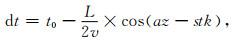
其中,dt为时移之差;v为不同震相(Pnl、Rayleigh、Love)的地震波传播速度;az为台站的方位角;stk为主震机制解任一断层面的走向;待求解量t0为主震和参考地震的震源持续时间之差;待求解量L为破裂长度,其正负号表示沿着或者逆着走向破裂.
针对倾滑型地震,我们采用类似的思想,在已有方法的基础上做了几点改进.
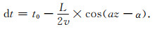
首先,倾滑型地震的两个节面的走向一般非常接近(相差约180°),直接应用相对质心定位法进行拟合很难判断破裂面.同时,当地震存在沿倾向的破裂时,起始破裂点与质心水平位置的连线不再与节面走向重合,而是存在一定夹角.因此,在新方法中,对时移进行拟合时同时搜索起始破裂点与质心水平位置的连线的方位角α:
|
(2) |
其次,在新方法中,引入了破裂起始点与质心点的相对深度来确定地震沿倾向的破裂方向性(图 2b).地震的起始深度由P、S初至到时测定,质心深度由波形拟合测定.与水平位置有所不同的是,质心深度一般可以通过拟合波形中的深度震相特征、体波面波振幅比等稳定获得(Chen et al., 2015),而起始深度的准确测定则难度较大(罗艳等,2013).Pn、Pg震相分别为下行波和上行波,结合二者到时可以较好约束地震的起始深度(魏星等,2019).我们同样采用参考地震,利用Pn、Pg到时差约束主震和参考地震的相对起始深度.假定参考地震的破裂面积小,起始深度与质心深度近似重合,在根据波形信息确定参考地震的质心深度后,令其等于参考地震的起始深度,再结合主震和参考地震的相对起始深度即可推断主震的起始深度.
利用新方法确定倾滑地震破裂方向性的流程如图 3所示.具体步骤为:

|
图 3 基于区域波形的测定方法流程图 Fig. 3 Flowchart of the major procedures to resolve the rupture directivity |
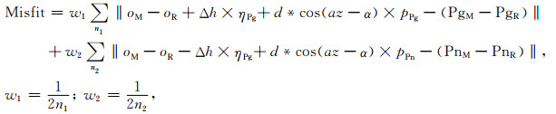
(1) 选择合适的参考地震(震级比主震小一个量级,和主震位置接近).分别拾取主震和参考地震的Pg、Pn震相到时,按照公式(3)进行拟合,利用最小二乘拟合来求解主震和参考地震的相对起始深度、相对水平位置.
|
(3) |
其中,w1、w2为到时数据的权重,n1、n2为记录到Pg、Pn的台站个数,通过加权使得Pg、Pn数据的权重相等.ηPg、ηPn为竖直慢度,pPg、pPn为水平慢度,均可以在给定地壳速度模型后计算得到.PgM、PgR为主震和参考地震的Pg到时,PnM、PnR为主震和参考地震的Pn到时.待求解量有:两个事件的起始震中的水平距离(d),二者连线的方位角(α),主震和参考地震的起始深度差(Δh),发震时刻误差(oM-oR).
(2) 根据第一步得到的主震和参考地震的相对水平位置,改正参考地震的位置.利用区域波形和CAP算法(Zhu and Helmberger, 1996)反演主震和参考地震的震源机制解和质心深度,及主震的震源持续时间.结合参考地震的质心深度、主震和参考地震的相对起始深度,得到主震的起始深度.根据主震的质心深度和起始深度,推断主震沿深度的破裂尺度.
(3) 由CAP算法输出主震及参考地震的不同震相波形时移,利用参考地震的波形时移对主震进行校正,得到时移差.对时移差按照公式2进行拟合,得到主震沿水平的破裂方向及破裂尺度.
(4) 结合前两步的结果,得到主震起始震中与质心震中在三维空间的相对位置.将其与主震的两个节面比较,最终得到主震的破裂方向性参数,包括破裂面、破裂长度、平均破裂速度等.
3 数据处理及分析我们按照图 3所示的流程对精河地震的波形数据进行处理分析.震后共发生3个ML4.5以上地震,其中1个余震发生在主震的12 min后,波形受主震面波干扰、信噪比低,因此,选择另外2个地震为参考事件(表 2).
|
|
表 2 主震及参考地震的发震时刻及本文得到的点源参数 Table 2 Earthquake source parameters of the mainshock and reference events |
从国家测震台网数据备份中心收集主震及参考事件在震中距350 km内的18个宽频台站的波形数据.根据Crust2.0速度模型(表 3)(Laske et al., 2001),计算得到Pn发育的最小震中距约120 km.为避免Pn、Pg到达时刻接近造成的拾取错误,选择120 km以内的台站拾取Pg震相,选取200 km以外的台站拾取Pn震相.最终,对每个事件拾取Pg震相3个,Pn震相17个.可以看到,Pg起跳尖锐,Pn起跳相对较缓;记录到Pn的台站方位角分布较好,其极性反映出主震和参考地震1的机制解存在一定的差异(图 4).
|
|
表 3 点源反演采用的速度模型(Crust2.0) Table 3 Velocity model used in source inversion (Crust2.0) |

|
图 4 主震及参考地震1的Pg、Pn拾取 (a)主震的Pg震相, 波形左上方分别是台站名、方位角、震中距; (b)主震的Pn震相; (c)参考地震1的Pg震相; (d)参考地震1的Pn震相. Fig. 4 Manually picked Pg and Pn phases of the mainshock and reference event #1 (a) Pg of the mainshock. Station name, azimuth and epicentral distance are marked above the waveform. (b) Pn of the mainshock. (c, d) The same as (a, b) but for reference event #1. |
将Pn、Pg到时数据代入公式(3)进行拟合.对参考地震1,得到其水平位置在主震的280°方向,相距7.1 km,起始深度比主震偏浅0.5 km(图 5a).对参考地震2,得到其水平位置在主震的285°方向,相距7.3 km,起始深度比主震偏浅4.3 km(图 5b).由图 4,对主震和参考地震1,Pn、Pg的拾取误差小于0.1 s.为了评估以上相对起始深度的不确定性,我们对每个台站的Pn、Pg到时数据添加随机误差(小于±0.1 s),再利用公式(3)进行拟合,共重复100次.结果显示,100次测试中,相对起始深度的误差均小于1.0 km,88次测试中,起始深度误差小于0.5 km.因此,本文获得的相对起始深度应较为可靠.根据主震及参考地震的水平位置差异,修正参考地震的位置.另外,测试了单独使用Pg或Pg进行相对定位,获取的结果显示水平位置稳定,但深度稳定性差;这可能是由于仅利用一种震相时利用最小二乘求解行列式存在病态矩阵.

|
图 5 对Pn、Pg到时差的最小二乘拟合结果 (a)对参考地震1, 红色圆点为主震和参考地震1的Pg到时差,蓝色圆点为Pn到时差,实线为相应的拟合结果; (b)对参考地震2. Fig. 5 Fitting result of the Pn-Pg differential data (a) For reference event #1. Red and blue dots show the Pg and Pn differential data between the mainshock and the reference event, respectively. Solid lines indicate the predicted values; (b) The same as (a) but for reference event #2. |
之后,应用CAP方法(Zhao and Helmberger, 1994; Zhu and Helmberger, 1996)求解主震及两个参考地震的点源参数.特别地,对主震额外搜索其震源持续时间,用于约束平均破裂速度.CAP反演时,Pnl震相时窗20 s,面波时窗60 s.对主震,滤波频段为Pnl部分0.05~0.2 Hz,面波部分0.05~0.1 Hz.对参考地震,采用了更低频的分量以提高震源机制解的稳定性,滤波频段为Pnl部分0.02~0.2 Hz,面波部分0.01~0.1 Hz.反演结果显示,主震为逆冲型,矩震级约6.2,质心深度21 km,震源持续时间5.5 s,两个双力偶节面分别为102°/45°/106°(NP1)和259°/47°/74°(NP2).Crust2.0速度模型显示该地区地壳厚度为50 km,表明本次地震发生在中地壳.参考地震1为走滑兼逆冲型,矩震级约4.2,质心深度17 km,两个双力偶节面分别为132°/73°/128°(NP1)和243°/41°/26°(NP2),机制解与主震存在较大差异.参考地震2为逆冲型,矩震级约4.7,质心深度12 km,两个双力偶节面分别为86°/41°/98°(NP1)和255°/49°/83°(NP2),与主震接近.由于参考地震2发震时刻距离主震较近,其波形受主震面波影响而信噪比低,波形拟合程度也低于参考地震1.
对参考地震1,由其质心深度(17 km),及主震与参考地震1的起始深度差(0.5 km),得到主震的起始深度约17.5 km.对参考地震2,由其质心深度(12 km),及主震与参考地震2的起始深度差(4.3 km),得到主震的起始深度约16.3 km.由两个参考地震得到的主震起始深度较为一致,偏差约1 km.主震起始深度(16.3~17.5 km)小于质心深度(21 km),得到主震沿倾向向下破裂,在深度上的破裂尺度约7 km.
接下来,进一步确定主震沿水平方向的破裂方向性.CAP算法可以输出Pnl、Rayleigh、Love震相的波形时移,由于Pnl、Love震相的波形拟合稍差(图 6、图 7),选用Rayleigh震相的时移差按照公式(2)进行拟合.首先,采用参考地震1的波形时移来进行路径校正,选择Rayleigh震相波形互相关系数大于0.85的5个台站进行拟合.结果显示,主震的质心震中在起始震中的225°方向,地震在水平方向的破裂长度为9.2 km(图 8a).在图 8a中,出现两个极值点,两个极值点对应的破裂方向相差180°,破裂长度正负号相反,因此,二者均对应了沿着225°方向破裂约9.2 km.以参考地震2的波形时移来进行路径校正,选择Rayleigh震相波形互相关系数大于0.75的3个台站进行拟合.结果显示,主震的质心震中在起始震中的235°方向,地震在水平方向的破裂长度为6.3 km(图 8b).由两个参考地震得到的主震沿水平的破裂方向一致,破裂长度接近.由于参考地震1的点源反演波形拟合好于参考地震2,拟合破裂方向性时选用的台站也更多,因此,认为以参考地震1为路径校正得到的水平破裂长度更可靠(约9 km).

|
图 6 主震的CAP反演结果及波形拟合.左侧显示拟合误差随震源持续时间及深度的变化,红色震源球对应误差最小时的机制解 Fig. 6 CAP inversion result of the mainshock and waveform comparison. The left panels show the misfit variation against different source duration and centroid depth. Red beach ball shows the solution with minimum misfit |

|
图 7 参考地震的CAP反演结果 (a)对参考地震1.左侧显示拟合误差随深度的变化,红色震源球对应误差最小时的机制解;(b)对参考地震2. Fig. 7 CAP inversion result of two reference events and waveform comparison (a) For reference event #1. The left panels show the misfit variation against different centroid depth. Red beach ball shows the solution with minimum misfit. (b) For reference event #2. |

|
图 8 水平破裂方向及时移拟合 (a)沿不同方向破裂的拟合误差,以参考地震1为路径校正.红点为最小误差对应的水平破裂方向; (b)最佳水平方向对应的时移拟合,以参考地震1为路径校正; (c)沿不同方向破裂的拟合误差,以参考地震2为路径校正; (d)最佳水平方向对应的时移拟合,以参考地震2为路径校正. Fig. 8 Fitting results of horizontal rupture directivity (a) For reference event #1. Dots show the misfit variation against different rupture direction. Red dot indicates the rupture direction with minimum misfit; (b) For reference event #1. Dots show the observed differential time data and solid line shows the best fit values; (c), (d) The same as (a), (b), but for reference event #2. |
一般来说,多数逆冲型地震的倾角小于45°.已有研究表明,有部分发生在上地壳的地震存在高角度逆冲,例如2011年MW5.8 Virginia地震(倾角50°,深度8 km)(Chapman, 2013)、2013 MW6.7年芦山地震(倾角47°,深度12 km)(曾祥方等,2013)、2017年MW6.2 British Columbia-Alaska地震(倾角61°,深度7 km)(He et al., 2018)等.2017年MW6.0呼图壁地震的发震构造也可能为高角度逆冲,但是仍存在较大争议(Lu et al., 2017; Yang et al., 2019; Wang et al., 2019).本文得到的点源参数及破裂方向性分析结果显示本次精河地震为发生在中地壳(21 km)的高角度逆冲地震(倾角45°),相对少见.
综合地震沿水平和沿深度的破裂特征,以及质心深度21 km,可获得地震在三维空间的破裂范围分布.将破裂区域与震源机制解的两个节面展示在一起,可以看到由破裂方向性测定得到的破裂范围与南倾的NP1节面近乎重合(图 9).地震沿着破裂起始点向西南方向、向下破裂,总破裂长度约11.5 km,其中,沿深度的破裂范围约7 km,沿水平方向的破裂范围约9 km.结合主震点源反演得到的震源持续时间5.5 s,精河地震的平均破裂速度约2.1 km·s-1,是该深度下剪切波速度的0.84倍,与经验关系一致(0.5~0.9倍剪切波速度)(Wang et al., 2016).

|
图 9 以参考地震1得到的破裂范围与震源机制解节面的示意图 Fig. 9 Illustration of the rupture area and two nodal planes |
精河地震发生在库松木契克断裂带内,该断裂带是天山北缘褶皱-逆断裂带上的活动断层带,由多条南倾的逆冲断层组成(图 1b),其中库松木契克山前断层、查汗图断层和精河南断层在晚第四纪都有活动的迹象(陈建波等,2007).根据InSAR观测获取的地震质心位置(中国地震局地质研究所InSAR工作组,2017)、本文利用波形反演得到的质心深度(21 km)、双力偶节面参数(倾角45°)、地震破裂方向性测定结果(断层面南倾),可以推断发震断层的地表出露位置,发现与精河南断层基本一致.地质考察也发现精河南断层表现出较强的活动特征:断层上盘上新统和下更新统西域砾岩变形显著,形成了一系列背斜构造;在背斜北翼,断层出露地表并断错了各级地貌面和沟谷阶地,形成了多条断续的、走向变化明显的、高度数米不等的断层陡坎(图 1c)(陈建波等, 2012a, b).基于这些信息,推断精河南断层的深部结构如图 10所示.余震主要分布在主震质心震中之上,这可能是由于断层在质心震中之下部分在同震破裂时应力释放较为完全.综上所述,结合地震学反演结果、卫星影像、野外地质观测,推断本次精河地震的发震断层为精河南断层,地震可能只破裂了断层的下段,并未破出地表.

|
图 10 精河地震的余震分布及可能的发震构造 红色为推断的发震断层,蓝色加粗段显示了同震破裂范围.余震为重定位结果(来源:房立华等,2017),已将其按照主震的起始位置、起始深度进行了相应的平移.震源球展示了主震的质心位置. Fig. 10 The distribution of relocated aftershocks and inferred seismogenic structure of the Jinghe earthquake Red line indicates the inferred rupture fault (Jinghenan fault) and blue thicken line indicates the area of co-seismic rupture. Dots show relocated aftershocks (from Fang et al., 2017), and they have been shifted relative to the hypocenter location and hypocenter depth of the mainshock. Beach ball shows the centroid location of the mainshock. |
新生代以来,印度板块与欧亚板块碰撞的远程效应使天山造山带再次复活(Molnar and Tapponnier, 1975; Tapponnier and Molnar, 1979; Hendrix et al., 1994),位于北天山西段的库松木契克山快速隆升并向北逆冲到准噶尔块体之上.精河南断裂作为两个块体之间边界断裂的一部分,控制和调节着南北两侧块体的差异性变形.库松木契克山沿着精河南断裂持续向北逆冲,应变在精河南断裂上不断积累,当其超过断裂带和地壳物质的强度时,断裂产生快速滑动,产生了精河MS6.6级地震.
天山内部一些继承性活动的深大断裂控制着活动块体的边界,这些断裂多为高角度、逆冲兼走滑性质的构造,在调节区域变形中具有重要作用(Bowman et al., 2004;Selander et al., 2012; Wu et al., 2019).北天山西段科古琴山体南麓的伊犁盆地北缘断裂是一条右旋逆冲构造,在断裂的南北两侧,发育有多条走向相似的逆冲断裂(图 1;罗福忠等,2003;陈建波等, 2012a, b).我们推测精河南断裂可能是从伊犁盆地北缘断裂上派生出的高角度逆冲构造,与北天山山前低角度的薄皮逆冲推覆构造不同.然而,该推断以及更精细的断层深部几何结构仍需小地震精定位、人工地震剖面等进一步研究佐证.
5 结论2017年8月9日的新疆精河MS6.6地震是近年来天山北缘的最大地震.本文针对倾滑型地震发展了一种基于区域地震波形的破裂方向性测定方法,应用该方法测定了精河地震的破裂方向性.结合震源参数反演、破裂方向性分析及余震精定位结果,精河地震是发生在中地壳(21 km)的高角度逆冲地震,地震的破裂面为南倾的NP1节面(102°/45°/106°),地震沿着破裂起始点向西南方向、向下破裂,总破裂长度约11.5 km,其中,沿深度的破裂范围约7 km,沿水平的破裂范围约9 km,平均破裂速度约2.1 km·s-1.余震主要分布在主震质心震中之上,这可能是由于断层在质心震中之下部分在同震破裂时应力释放较为完全.综合地质资料、卫星影像等判定本次地震的发震断层为精河南断层,地震可能只破裂了断层的下段,并未破出地表.
致谢 感谢中国地震局地球物理研究所国家测震台网数据备份中心(doi:10.11998/SeisDmc/SN)为本研究提供地震波形数据,感谢房立华研究员提供余震重定位结果.部分图件由Generic Mapping Tools (GMT) 4.5.9绘制.
Bai L S, Liu J, Zhang Y Y, et al. 2017. Relocation of the 2017 MS6.6 Jinghe, Xinjiang earthquake sequence and its seismogenic structure. Earthquake Research in China (in Chinese), 33(4): 703-711. |
Bowman D, Korjenkov A, Porat N. 2004. Late-Pleistocene seismites from Lake Issyk-Kul, the Tien Shan range, Kyrghyzstan. Sedimentary Geology, 163(3-4): 211-228. DOI:10.1016/S0037-0738(03)00194-5 |
Chapman M C. 2013. On the rupture process of the 23 August 2011 Virginia earthquake. Bulletin of the Seismological Society of America, 103(2A): 613-628. DOI:10.1785/0120120229 |
Chen J, Tan M, Wu G, et al. 2012b. The seismic damage characteristic and the cause of the Jinghe M5.0 Earthquake in Xinjiang on Oct. 16, 2011. Technology for Earthquake Disaster Prevention (in Chinese), (2): 164-172. |
Chen J B, Shen J, Li J, et al. 2007. Preliminary study on new active characteristics of Kusongmuxieke mountain front fault in the west segment of North Tianshan. Northwestern Seismological Journal (in Chinese), 29(4): 335-340. |
Chen J B, Tan M, Wu G D, et al. 2012a. The characteristic of seimic hazard and Seismogenic structure of Jinghe Earthquake with MS5.0 in Xinjiang on Oct 16th, 2011. Inland Earthquake (in Chinese), 26(3): 233-241. |
Chen W W, Ni S D, Kanamori H, et al. 2015. CAPjoint, a computer software package for joint inversion of moderate earthquake source parameters with local and teleseismic waveforms. Seismological Research Letters, 86(2A): 432-441. DOI:10.1785/0220140167 |
Deng Q D. 1991. Progress on active faults research.//Research on Active Faults (in Chinese). Beijing: Seismological Press.
|
Fang L H, Wu J P, Wang W L, et al. 2013. Relocation of the mainshock and aftershock sequences of MS7.0 Sichuan Lushan earthquake. Chinese Science Bulletin, 58(28-29): 3451-3459. DOI:10.1007/s11434-013-6000-2 |
Fang L H, Wang W L, Yang T. 2017. Relocation of the 2017 Jinghe earthquake sequence (in Chinese). In: Atlas on the August 09, 2017 Jinghe M6.6 Earthquake.
|
Han L B, Zeng X F, Jiang C S, et al. 2014. Focal mechanisms of the 2013 MW6.6 Lushan, China earthquake and high-resolution aftershock relocations. Seismological Research Letters, 85(1): 8-14. DOI:10.1785/0220130083 |
He X, Ni S. 2017. Rapid rupture directivity determination of moderate dip-slip earthquakes with teleseismic body waves assuming reduced finite source approximation. Journal of Geophysical Research:Solid Earth, 122(7): 5344-5368. DOI:10.1002/2016JB013924 |
He X, Ni S, Zhang P, et al. 2018. The 1 May 2017 British Columbia-Alaska earthquake doublet and implication for complexity near southern end of Denali fault system. Geophysical Research Letters, 45(12): 5937-5947. |
He X H, Ni S D, Liu J. 2015. Rupture directivity of the August 3rd, 2014 Ludian earthquake (Yunnan, China). Science China Earth Science, 58(5): 795-804. DOI:10.1007/s11430-015-5053-2 |
He X H, Zhang D L, Zhang P Z. 2019. Rupture directivity of moderate earthquakes and its application to the determination of seismogenic faults. Progress in Geophysics, 34(6): 2158-2168. |
Heaton T H. 1982. The 1971 San Fernando earthquake:A double event?. Bulletin of the Seismological Society of America, 72(6A): 2037-2062. |
Hendrix M S, Dumitru T A, Graham S A. 1994. Late Oligocene-early Miocene unroofing in the Chinese Tian Shan:An early effect of the India-Asia collision. Geology, 22(6): 487-490. DOI:10.1130/0091-7613(1994)022<0487:LOEMUI>2.3.CO;2 |
Huang H H, Aso N, Tsai V C. 2017. Toward automated directivity estimates in earthquake moment tensor inversion. Geophysical Journal International, 211(2): 1062-1076. DOI:10.1093/gji/ggx354 |
Insar Working Group, Institute of Geology, CEA. 2017. InSAR analysis results of the M6.6 Jinghe, Xinjiang earthquake on August 9, 2017 (in Chinese). In: Atlas on the August 09, 2017 Jinghe M6.6 Earthquake.
|
Jiang X H, Han Y Y, Yang W, et al. 2017. Preliminary analysis of the 2017 Jinghe MS6.6 earthquake sequence and its seismic source characteristics. Earthquake Research in China (in Chinese), 33(4): 682-693. |
Laske G, Masters G, Reif C. 2001. CRUST2.0: a new global crustal model at 2×2 degrees. https://igppweb.ucsd.edu/~gabi/crust2.html. (last accessed 2019.08)
|
Li T, Chen J, Fang L H, et al. 2016. The 2015 MW6. 4 Pishan earthquake:Seismic hazards of an active blind wedge thrust system at the Western Kunlun range front, northwest Tibetan Plateau. Seismological Research Letters, 87(3): 601-608. |
Li T, Chen Z X, Chen J, et al. 2019a. Along-strike and downdip segmentation of the Pamir Frontal Thrust and its association with the 1985 MW6. 9 Wuqia earthquake. Journal of Geophysical Research:Solid Earth, 124(9): 9890-9919. DOI:10.1029/2019JB017319 |
Li T, Schoenbohm L, Chen J, et al. 2019b. Cumulative and coseismic (during the 2016 MW6.6 Aketao earthquake) deformation of the dextral-slip Muji Fault, northeastern Pamir orogeny. Tectonics. DOI:10.1029/2019TC005680 |
Liang S S, Liu J G, Zou L Y, et al. 2017. Relocation of the 2017 Jinghe earthquake sequence (in Chinese). In: Atlas on the August 09, 2017 Jinghe M6.6 Earthquake.
|
Liu J M, Gao R, Wang Q, et al. 2017. Relocation of the Jinghe MS6.6 earthquake sequence on August 9, 2017 and analysis of the seismogenic structure. Earthquake Research in China (in Chinese), 33(4): 663-670. |
Lu R Q, He D F, Xu X W, et al. 2017. Seismotectonics of the 2016 M6.2 Hutubi Earthquake:Implications for the 1906 M7.7 Manas Earthquake in the Northern Tian Shan Belt, China. Seismological Research Letters, 89(1): 13-21. |
Luo F Z, Bai M X, Chen J B. 2003. Study on new activity characteristics of the active faults in Yining basin of Xinjiang. Inland Earthquake (in Chinese), 17(1): 4-10. |
Luo Y, Zeng X F, Ni S D. 2013. Progress on the determination of focal depth. Progress in Geophysics (in Chinese), 28(5): 2309-2321. DOI:10.6038/pg20130513 |
Luo Y, Hsieh M C, Zhao L. 2018. Source rupture process of the 2014 MS6.5 Ludian, Yunnan, China, earthquake in 3D structure:the strain green's tensor database approach. Bulletin of the Seismological Society of America, 108(6): 3270-3277. DOI:10.1785/0120180090 |
Mignan A, Danciu L, Giardini D. 2015. Reassessment of the maximum fault rupture length of strike-slip earthquakes and inference on Mmax in the Anatolian Peninsula, Turkey. Seismological Research Letters, 86(3): 890-900. DOI:10.1785/0220140252 |
Molnar P, Tapponnier P. 1975. Cenozoic tectonics of Asia:effects of a continental collision. Science, 189(4201): 419-426. DOI:10.1126/science.189.4201.419 |
Qin L B, Chen W W, Ni S D, et al. 2014. A method of resolving earthquake rupture directivity with relative centroid location and its application to the 2008 Yingjiang MS6.0 earthquake. Chinese Journal of Geophysics (in Chinese), 57(10): 3259-3269. DOI:10.6038/cjg20141014 |
Ross Z E, Ben-Zion Y. 2016. Toward reliable automated estimates of earthquake source properties from body wave spectra. Journal of Geophysical Research:Solid Earth, 121(6): 4390-4407. DOI:10.1002/2016JB013003 |
Selander J, Oskin M, Ormukov C, et al. 2012. Inherited strike-slip faults as an origin for basement-cored uplifts:Example of the Kungey and Zailiskey ranges, northern Tian Shan. Tectonics, 31(4): TC4026. DOI:10.1029/2011TC003002 |
Tan Y, Helmberger D. 2010. Rupture directivity characteristics of the 2003 Big Bear sequence. Bulletin of the Seismological Society of America, 100(3): 1089-1106. DOI:10.1785/0120090074 |
Tapponnier P, Molnar P. 1979. Active faulting and Cenozoic tectonics of the Tien Shan, Mongolia, and Baykal regions. Journal of Geophysical Research:Solid Earth, 84(B7): 3425-3459. DOI:10.1029/JB084iB07p03425 |
Wang D, Mori J, Koketsu K. 2016. Fast rupture propagation for large strike-slip earthquakes. Earth and Planetary Science Letters, 440: 115-126. DOI:10.1016/j.epsl.2016.02.022 |
Wang X H, Xu C J, Wen Y M, et al. 2019. The 2016 MW6. 0 Hutubi earthquake:A blind thrust event along the northern Tian Shan front. Journal of Asian Earth Sciences, 173: 79-87. |
Warren L M. 2014. Dominant fault plane orientations of intermediate-depth earthquakes beneath South America. Journal of Geophysical Research:Solid Earth, 119(7): 5762-5785. DOI:10.1002/2013JB010856 |
Wei X, Wang X T, Li Z W, et al. 2019. Initial rupture depth of the 8 August 2017 M7. 0 Jiuzhaigou earthquake derived from Pn/Pg relative location. Chinese Journal of Geophysics (in Chinese), 62(4): 1300-1311. DOI:10.6038/cjg2019L0796 |
Wu C Y, Zheng W J, Zhang P Z, et al. 2019. Oblique thrust of the Maidan fault and late Quaternary tectonic deformation in the southwestern Tian Shan, Northwestern China. Tectonics, 38(8): 2625-2645. DOI:10.1029/2018TC005248 |
Yalikun A, Chang X D, Sun J, et al. 2017. Assessment of disaster losses and reconstruction after the Jinghe earthquake with MS6.6 in Xinjiang on August 9, 2017. Earthquake Research in China (in Chinese), 33(4): 781-788. |
Yang Y H, Hu J C, Chen Q, et al. 2019. A blind thrust and overlying folding earthquake of the 2016 MW6.0 Hutubi earthquake in the Northern Tien Shan Fold-and-Thrust Belts, China. Bulletin of the Seismological Society of America, 109(2): 770-779. DOI:10.1785/0120180150 |
Zeng X F, Luo Y, Han L B, et al. 2013. The Lushan MS7.0 earthquake on 20 April 2013:A high-angle thrust event. Chinese Journal of Geophysics (in Chinese), 56(4): 1418-1424. DOI:10.6038/cjg20130437 |
Zhang P Z, Mao F Y. 1996. Quantitative study of active faults and probability assessment of medium and long-term seismic hazards.//Theory and Research on Active Faults (in Chinese). Beijing: Seismological Press.
|
Zhang P Z, Deng Q D, Zhang G M, et al. 2003. Active tectonic blocks and strong earthquakes in the continent of China. Science in China Series D: Earth Sciences, 46(S2): 13-24. DOI:10.3969/j.issn.1674-7313.2003.z2.002 |
Zhao L S, Helmberger D V. 1994. Source estimation from broadband regional seismograms. Bulletin of the Seismological Society of America, 84(1): 91-104. |
Zhu L, Helmberger D V. 1996. Advancement in Source Estimation Techniques Using Broadband Regional Seismograms. Bulletin of the Seismological Society of America, 86(5): 1634-1641. |
阿里木江·亚力昆, 常想德, 孙静, 等. 2017. 2017年8月9日精河6.6级地震灾害损失及灾后恢复重建经费评估. 中国地震, 33(4): 781-788. DOI:10.3969/j.issn.1001-4683.2017.04.035 |
白兰淑, 刘杰, 张莹莹, 等. 2017. 2017年精河6.6级地震余震序列重新定位和发震构造. 中国地震, 33(4): 703-711. DOI:10.3969/j.issn.1001-4683.2017.04.026 |
陈建波, 沈军, 李军, 等. 2007. 北天山西段库松木楔克山山前断层新活动特征初探. 西北地震学报, 29(4): 335-340. |
陈建波, 谭明, 吴国栋, 等. 2012a. 2011年10月16日新疆精河县5.0级地震震害特征及发震构造. 内陆地震, 26(3): 233-241. |
陈建波, 谭明, 吴国栋, 等. 2012b. 2011年10月16日新疆精河县5.0级地震震害特征及原因. 震灾防御技术, 7(2): 164-172. |
邓起东. 1991.活动断裂研究的进展与方向.//活动断裂研究.北京: 地震出版社.
|
房立华, 吴建平, 王未来, 等. 2013. 四川芦山MS7.0级地震及其余震序列重定位. 科学通报, 58(20): 1901-1909. |
房立华, 王未来, 杨婷. 2017. 2017年精河地震余震精定位图.见: 2017年08月09日新疆精河6.6级地震图集.
|
何骁慧, 倪四道, 刘杰. 2015. 2014年8月3日云南鲁甸M6.5地震破裂方向性研究. 中国科学:地球科学, 45(3): 253-263. |
何骁慧, 张冬丽, 张培震. 2019. 中强地震破裂方向性测定方法及其在发震断层判定中的应用. 地球物理学进展, 34(6): 2158-2168. |
姜祥华, 韩颜颜, 杨文, 等. 2017. 2017年精河MS6.6地震序列及震源特征初步分析. 中国地震, 33(4): 682-693. DOI:10.3969/j.issn.1001-4683.2017.04.024 |
梁姗姗, 刘敬光, 邹立晔等. 2017. 2017年精河地震余震精定位图.见: 2017年08月09日新疆精河6.6级地震图集.
|
刘建明, 高荣, 王琼, 等. 2017. 2017年8月9日精河6.6级地震序列重定位与发震构造初步研究. 中国地震, 33(4): 663-670. DOI:10.3969/j.issn.1001-4683.2017.04.022 |
罗福忠, 柏美祥, 陈建波. 2003. 新疆伊宁盆地活动断裂新活动特征研究. 内陆地震, 17(1): 4-10. DOI:10.3969/j.issn.1001-8956.2003.01.002 |
罗艳, 曾祥方, 倪四道. 2013. 震源深度测定方法研究进展. 地球物理学进展, 28(5): 2309-2321. DOI:10.6038/pg20130513 |
秦刘冰, 陈伟文, 倪四道, 等. 2014. 基于相对质心震中的地震破裂方向性测定方法研究:以2008年云南盈江MS6.0地震为例. 地球物理学报, 57(10): 3259-3269. DOI:10.6038/cjg20141014 |
魏星, 王向腾, 李志伟, 等. 2019. 基于Pn/Pg相对定位方法研究2017年8月8日九寨沟M7.0地震起始破裂深度. 地球物理学报, 62(4): 1300-1311. DOI:10.6038/cjg2019L0796 |
曾祥方, 罗艳, 韩立波, 等. 2013. 2013年4月20日四川芦山MS7.0地震:一个高角度逆冲地震. 地球物理学报, 56(4): 1418-1424. DOI:10.6038/cjg20130437 |
张培震, 毛凤英. 1996.活动断裂定量研究与中长期强地震危险性概率评价.//活动断裂研究: 理论与应用北京: 地震出版社.
|
张培震, 邓起东, 张国民, 等. 2003. 中国大陆的强震活动与活动地块. 中国科学(D辑), 33(S1): 12-20. |
中国地震局地质研究所InSAR工作组. 2017. 2017年8月9日新疆精河6.6级地震InSAR分析结果.见: 2017年08月09日新疆精河6.6级地震图集.
|