印度板块在约50百万年前与欧亚板块碰撞,在不断的会聚过程中使得青藏高原地壳缩短量超过1500 km,进而形成青藏高原(Armijo et al., 1986;England and Houseman, 1986;England and Molnar, 1997).时至今日,青藏高原东北缘受印度板块持续向北运动的远端效应影响,仍在不断隆升与扩展.与青藏高原东北缘毗连的华北克拉通在古元古代晚期至早中生代期间一直保持相对稳定状态.晚中生代以来,华北克拉通在古太平洋板块的俯冲过程中其东部产生大规模变形,进而导致岩石圈减薄和地幔性质转变,进一步引起华北克拉通内部的鄂尔多斯地体开始向东南方向运动.青藏高原和华北克拉通作为中国大陆构造活动最为强烈的区域,其构造边界周缘分布大量的活动断层,在鄂尔多斯西缘、西南缘、青藏高原东北缘、阿拉善地块和西秦岭之间形成南北地震带北段(邓起东等, 2002, 2003;张培震等, 2002, 2006;张岳桥等,2006;朱日祥等, 2011, 2012).该地区的深部结构对理解块体之间的相互作用、青藏高原东北缘扩张的动力学模型及强震机理与预测极为关键,但目前鄂尔多斯地块、阿拉善地块及其边界带区域的地震学观测资料相对较少,所以该区域深部地震学证据的获取尤为重要.
鄂尔多斯地体在晚中生代经历稳定的地层沉积,晚白垩纪时期开始大面积隆升且其周缘发育一系列的剪切拉张型断陷盆地(邓起东等,1999).因受上地幔东南方向的拖曳和青藏高原东北缘不断扩张的作用下鄂尔多斯地块产生逆时针运动,表现为相对于阿拉善地块的右旋走滑的运动学特征(Zhang et al., 2003;张岳桥等,2006).阿拉善地块作为一个长期隆升的稳定构造单元,相比青藏高原东北缘内部的其他块体基底更加古老和坚硬(Vincent and Allen, 1999;Shi et al., 2017).第四纪以来,青藏高原东北缘的扩张主导了阿拉善地块的构造活动,阿拉善地体在周缘大型断裂的共同调节作用下整体缓慢向东运动,与贺兰山和鄂尔多斯地体会聚(Zheng et al., 2013a, b;Yu et al., 2016).阿拉善地块和鄂尔多斯地块之间的边界带是银川—河套断陷盆地,其成因被认为是由于太平洋板块向西俯冲和印度—欧亚板块碰撞引起的地幔对流所致(Tian et al., 1992;Northrup et al., 1995;Liu et al., 2004).银川—河套断陷盆地地震活动强烈,历史上曾发生过1739年平罗8级强震(雷启云等,2015).
20世纪90年代以来,众多学者对鄂尔多斯及阿拉善地块的地壳、上地幔介质物性结构研究开展大量工作.詹艳等(2008)利用电磁测深发现阿拉善上地壳高电阻率特征,Tian等(2011)基于接收函数方法获得鄂尔多斯北部相对稳定的地壳结构,Guo等(2019)利用近震层析成像得到贺兰山—银川盆地构造带地壳范围内低VP速度结果等.Dong等(2014)和Tian等(2009)分别利用三维电性结构反演和远震层析成像给出阿拉善地块和鄂尔多斯地块之间存在明显的高低阻和高低地震波速现象等.已有研究更多关注的是阿拉善与青藏高原东北缘或鄂尔多斯地块与阴山造山带的深部构造关系,对阿拉善和鄂尔多斯地块之间的接触关系探讨相对较少.与此同时,鄂尔多斯西缘北段的野外作业环境恶劣,地球物理的观测数据较少,以至该区域块体间的变形关系研究和深部的地震学证据较为缺乏.
布设于青藏高原东北缘区域内中国科学探测台阵二期项目(中国地震科学台阵,2006)为进一步探测研究南北带北段地壳和岩石圈结构提供了重要的数据基础.本文利用其中部分流动台站的远震波形数据,采用接收函数共转换点叠加方法获取研究区域内的地壳间断面结构,并进一步讨论鄂尔多斯与阿拉善的速度间断面结构特征及其深部构造关系.
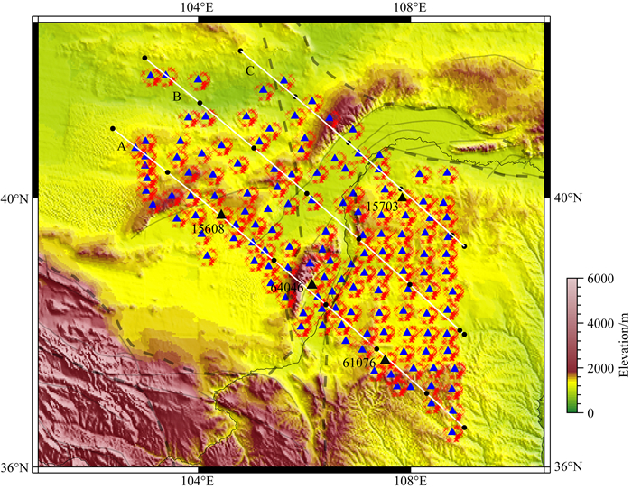
1 数据及方法 1.1 数据本文选择了位于青藏高原东北缘中国地震科学探测台阵项目二期(ChinaArray Ⅱ)的142个流动台站记录的远震波形,台站的观测时间为2013—2015年.台站覆盖了鄂尔多斯、阿拉善地块及其边界带,观测剖面为北西西方向,台间距为~35 km(图 2).

|
图 2 文中所用台站及分布 图中A、B和C白线为本文剖面位置,剖面上黑色圆点间隔距离为1°,蓝色三角形为本文所用台站,红色十字代表P-s转换点的50 km深部的分布位置,黑色三角形台站为展示所用台站15608、64046、61076和15703,灰色实线为该区域断层分布. Fig. 2 Station distribution White lines stand for the profiles in this study, the black dots have a one-degree interval, red crosses stand for conversion point of PRFs (at a depth of 50 km), blue triangles represent the station, the black ones used for this paper, gray lines stand for location of faults. |
为了获取稳定的Moho面和壳内间断面结构,本文使用接收函数的共转换点叠加技术进行成像(Yuan et al., 1997; Dueker and Sheehan, 1997).近年来,从远震波形中分离接收函数的方法已经成功应用于全球各个地区的地壳和上地幔间断面研究(Langston,1979;Farra and Vinnik, 2000;Kumar et al., 2006).接收函数的本质是基于等效震源假定条件下,从远震波形中提取的台站下方速度间断面Ps转换震相与直达P波的相对到时差序列(Langston,1979;Farra and Vinnik, 2000).本文使用基于多台站垂向分量叠加的多道最大或然性反褶积方法(MMLD)提取P波接收函数,在获取更接近真值震源因子的同时对由横向非均匀引起的噪声进行有效压制(刘启元等, 1996; 刘启元和Kind,2004).

|
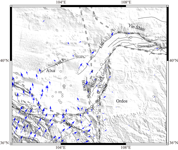
图 1 研究区域构造背景 图中灰色虚线为主要块体构造边界,灰色实线为该区域断层分布,黑色圆圈为历史地震,蓝色箭头是以鄂尔多斯为参照的GPS速度场(Liang et al., 2013). Alxa—阿拉善地块,Ordos—鄂尔多斯地块,NETP—青藏高原东北缘,YC-HT Graben—银川河套断陷盆地,Helan—贺兰山,Yin Shan—阴山,HYF—海原断裂,HHF—黄河断裂,YBLF—雅布赖山前断裂,LSF—狼山断裂,HSWF—贺兰山西麓断裂. Fig. 1 Tectonic setting of the research area Gray dash lines stand for the boundaries of tectonic unit of main blocks, gray lines stand for distributed of faults, black circles denote the history earthquakes, blue arrows display GPS velocity vectors (Liang et al., 2013). NETP, Northeastern Tibetan Plateau; HYF, Haiyuan fault; HHF, Huanghe fault; YBLF, Yabrai range-front fault; LSF, Langshan fault; HSWF, Helan Shan west-piedmont fault. |
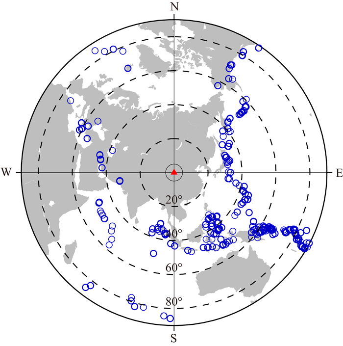
我们选取震级MS>5.5且震中距在30°~90°的远震事件进行P波接收函数分离(图 3).接收函数的分离主要为两大步骤,即坐标旋转和反褶积计算(Kumar et al., 2006).地震事件波形选取了2~20 s的Butterworth滤波器进行带通滤波,对提取的P波接收函数进行0.05~1 Hz带通滤波.上文提到,我们使用接收函数共转换点叠加的技术来研究沿剖面位置(图 2)的Moho面及壳内间断面的横向变化(Zhu and Kanamori, 2000).研究区域内的台站呈二维面状的均匀分布,所以本文采用三维的共转换点叠加方法,从而获取三维速度间断面结构.本文首先利用IASP91速度模型(基于CRUST 1.0对地壳厚度进行修正)对接收函数进行时深转换,水平方向采用0.1°×0.1°进行网格划分以及在垂直方向选择1 km层间厚度(基于波长).对于每个穿刺点,我们利用高斯函数进行水平向的平滑(根据转换点深度的菲涅尔半径):

|
图 3 远震事件分布图 Fig. 3 Distribution of teleseismic events used in this study |

|
(1) |
其中,Ap为转换点的界面信息幅值,Ar和G(Dr)分别为距转换点距离为Dr的网格内界面信息强度和高斯平滑参数.G(Dr)的计算公式如下:

|
(2) |
式中DF为转换点的菲涅尔半径,本文通过调整σ的大小给出参数叠加网格内的平滑参数,σ值的选取基于台站位置的分布距离.菲涅尔半径的计算公式如下:

|
(3) |
式中,Z为界面的深度,T为数据的主周期,V为地下介质的剪切波速度(Yilmaz,1987).最后我们进行共转换点叠加以及对其进行归一化计算获取成像结果.本文利用的三维共转换点叠加技术,在基于数据分布的情况下调整平滑参数,获取更为清晰的三维速度间断面结构的同时可进一步给出研究区域下方更为丰富的横向非均匀的细节特征,进而为该区域的深部结构提供更为可靠的地震学证据.
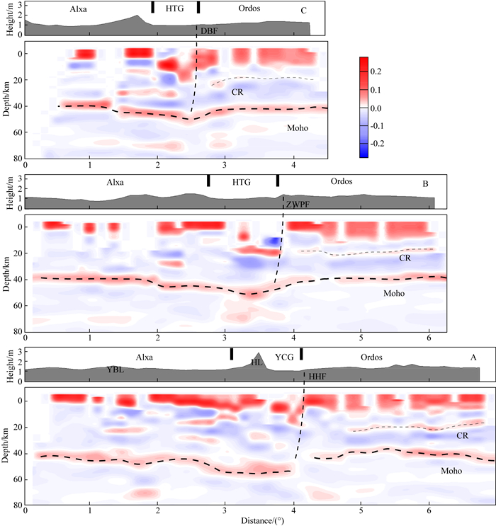
1.3 Moho及壳内间断面结构成像结果根据图 2中给出的剖面位置,我们应用接收函数共转换点叠加方法获得研究区域内的0~80 km深度范围内的速度间断面结构(图 4).图 4A、B、C分别对应图 2中A、B、C剖面位置的成像结果,三条剖面中所覆盖的鄂尔多斯地块间断面结构有较好的一致性,其地壳厚度在38~42 km之间,阿拉善地区的Moho面深度为38~45 km.河套盆地地壳厚度约52 km,而银川断陷盆地和贺兰山下方的Moho面最深为~55 km.

|
图 4 沿A、B和C剖面的速度间断面结构 HTG—河套断陷盆地,YCG—银川断陷盆地,HL—贺兰山,YBL—雅布赖山,HHF—黄河断裂, ZWPF—卓子山西麓断裂, DBF—磴口本井断裂. Fig. 4 Velocity discontinuities structure along three vertical profiles HTG, Hetao Graben; YCG, Yinchuan Graben; HL, Helan Shan; YBL, Yabrai Shan; HHF, Huanghe fault; ZWPF, Zhuozishan West Piedmont fault; DBF, Dengkou-Benjing fault. |
在A剖面中,阿拉善地块内部Moho面深度为~42 km,且壳内的间断面结构有明显的东西差异.在雅布赖山西部地壳内部无明显间断面结构,但在雅布赖山下约23 km深度有长约70 km的连续正震相界面(康拉德界面).贺兰山以西100 km范围内18 km和28 km深度均存在连续的极性为正的界面,且自西向东上方的界面逐渐变浅而下方界面与之相反,其深度在贺兰山以西30 km处分别为13 km和38 km,即中地壳呈逐渐变厚迹象.值得注意的是,在贺兰山以西30 km至银川盆地东缘地壳厚度高达~55 km.贺兰山和银川盆地下方壳内间断面结构横向非均匀性较强,在黄河断裂下方的莫霍面存在明显错断,Moho面在鄂尔多斯西缘边界跃升至~42 km,在西缘边界以东的50 km处莫霍面深度又存在小范围的抬升,地壳厚度为~38 km.沿A剖面继续向东的Moho面深度为40 km,以37.5°N为界,鄂尔多斯内部地壳厚度逐渐变深至~42 km,鄂尔多斯壳内的康拉德间断面(CR)连续可追踪,深度由~22 km逐渐变浅至~17 km.
在B剖面中,阿拉善地块至狼山西缘以西30 km处地壳厚度为~39 km,且无明显的壳内间断面信息.狼山以东至河套盆地东缘Moho面从45 km逐渐加深至50 km,沿B剖面继续向东莫霍面呈变浅特征,至鄂尔多斯地体西缘以东30 km达到40 km的深度,同时在鄂尔多斯内部地壳仍保持稳定成层结构,上下地壳界面(CR)和Moho面深度分别为20 km和40 km.C剖面中地壳整体结构呈现出与A,B剖面类似的特征,狼山以西的阿拉善地块内部地壳厚度为40 km,鄂尔多斯内部地壳厚度为~42 km.阿拉善和鄂尔多斯地块边界带上的河套盆地的莫霍面深度从两侧块体逐渐加深至50 km.鄂尔多斯地块内部的壳内间断面由南向北逐渐变弱,在C剖面中的鄂尔多斯地块壳内间断面已变得不明显.
通过比对鄂尔多斯地块内分别位于A和C剖面位置15703和61076台站所分离的接收函数(图 5)表明,两台站中不同方位角数据的~2.6 s和~2.9 s处分别存在振幅为正的壳内转换波震相(康拉德界面),上、下地壳间断面与Moho界面的转换波的相对到时差相差~0.8 s,但是15703台站中该震相能量较弱以至成像过程中被下地壳能量较强的负震相所覆盖.通过观察台站数据可知,鄂尔多斯地块北部康拉德界面信息强度明显低于其中部,鄂尔多斯中部下地壳厚度小于北部地块.同时,图 6给出A剖面内分别位于阿拉善、银川盆地和鄂尔多斯内部的15608、64046和61076台站接收函数数据,相比61076台站接收函数在2.9 s处存在覆盖所有方位角的壳内CR界面转换波震相,15608台站的接收函数仅在5.9 s处的Moho界面的Ps转换波震相.值得注意的是,银川盆地内64046台站因地表松散沉积层的原因引起接收函数直达信号有所滞后,以致数据在0时刻振幅能量几乎为零,导致在偏移成像图 4中银川盆地地表及下方浅部界面信息很弱且呈白色.不同台站的接收函数均与本文给出的间断面结构成像结果保持一致.图 7展示的是本文利用已有鄂尔多斯区域研究结果的简化速度模型进行的接收函数正演(陈九辉等,2005).由图可知,1~2.6 s之间存在由沉积层引起的转换波及多次波相耦合的震相信息,在3.5 s附近和5~6 s之间存在康拉德界面和Moho面的转换震相,以及康拉德界面造成的正振幅信号(8~10 s).这与本文给出的图 4、5中接收函数保持一致,进一步证明本文使用数据和成像结果的可靠性.根据已有的速度结构可知,鄂尔多斯地表存在速度较低的沉积层,基于该特征正演的接收函数可知其康拉德和莫霍面转换震相之间存在负振幅能量信息(图 7),这与图 5展示的接收函数数据也有较好的一致性.同时,陈九辉等(2005)利用相似波形的接收函数反演得到了较低的上地壳速度结构,故图 5中3~5 s的负震相可能由于上地壳的低速造成,并不是中下地壳存在低速层.

|
图 5 台站15703 (a)和61076 (b)接收函数对比 Fig. 5 Receiver functions of stations (a) 15703 and (b) 61076 |

|
图 6 台站15608 (a)、64046 (b)和61076 (c)接收函数对比 Fig. 6 Receiver functions of stations (a) 15608, (b) 64046 and (c) 61076 |

|
图 7 速度模型及接收函数正演 Fig. 7 Synthetic receiver function |
我们通过采用喜马拉雅计划二期台阵部分台站在2013—2015年所记录的远震波形数据,利用接收函数偏移成像方法,获取青藏高原东北缘邻区下方0~80 km速度间断面结构.本文的台站分布主要覆盖阿拉善地块、鄂尔多斯地块,图 4中给出沿剖面位置的Moho面和壳内界面的横向变化特征.根据已获得的间断面成像结果可知,阿拉善地块和鄂尔多斯地块在地壳深度范围内间断面结构差异明显,阿拉善地区的Moho面深度为38~45 km,地壳在块体构造边缘(贺兰山东侧)最厚;鄂尔多斯的结构符合其具有稳定性质的克拉通认知,康拉德界面和Moho面横向变化较弱,分别处于18~22 km和38~42 km的深度.同时,位于两块体之间的河套盆地地壳深度较深为~52 km.
2.1 地壳结构与前人结果对比我们根据该区域已有的研究成果,试图进一步对本文所关注的阿拉善和鄂尔多斯地区岩石圈间断面结构成像进行解释与讨论.
本文的结果与前人利用H-κ扫描技术所获取的Moho深度变化保持一致(王兴臣等, 2017;Xu et al., 2018).为了提高成像分辨率以及尽量避免横向非均匀对成像结果的影响,本文在不同深度的成像过程中只选取射线所覆盖菲涅尔半径内的转换点进行叠加.Xu等(2018)基于多台叠加H-κ扫描和联合反演方法获得东北缘及周围邻区的地壳深度分布,通过对比可发现与本文的成像结果保持一致,鄂尔多斯地块的地壳深度稍浅于阿拉善地区的Moho面深度.方盛明等(2009)采用反射方法测深给出横跨贺兰山与银川盆地下方地壳的精细速度结构,剖面东侧即鄂尔多斯西缘的成像结果与本文的间断面有较好的一致性,即CR界面和Moho面分别处于~20 km和~40 km的深度;处于银川断陷盆地东缘的黄河断裂为超大断裂,在其下方的Moho界面有明显的错断现象.同时,王鑫等(2010)给出相近区域的二维电性结构显示鄂尔多斯西部20 km深度上方以高阻为主,20 km以下深度存在明显的低阻特征;以黄河断裂为界的东西两侧30 km深度范围内有显著的高低阻差异,而阿拉善地块的地壳存在高阻的电性结构.Dong等(2014)采用三维长周期大地电磁反演获取鄂尔多斯及邻区岩石圈范围的电性结构,成像结果中可知阿拉善地块与鄂尔多斯地块在150 km深度范围内存在明显的电性结构差异,阿拉善岩石圈存在高阻结构,鄂尔多斯地块同样表现出成层的电性结构特征,上地壳以高电阻为主,下地壳直至岩石圈地幔都存在显著的低阻结构.李晨晶等(2017)获取的鄂尔多斯西部的电性结构中也得到相近的结果.通过面波、体波和接收函数获取的S和P波速度结构中同样显示阿拉善地体与鄂尔多斯地体的地壳结构差异和鄂尔多斯地壳较好的成层性特征(陈九辉等,2005;Li et al., 2017;高翔等,2018;郑晨等,2018).
根据已有的地震学和电性结构研究成果表明,阿拉善地块与鄂尔多斯地块的地壳范围物性结构存在明显差异;且鄂尔多斯作为古老克拉通其深部结构具有成层性和稳定性,以及构造边界下方的Moho面存在急剧变化的特征;同时,银川—河套断陷盆地地壳厚度大于两侧阿拉善和鄂尔多斯地块.这均与本文给出研究区域内岩石圈间断面的成像结果保持一致.
2.2 构造边界深部作用揭示上文提到,在上新世末,阿拉善地块在周缘大型断裂和次级块体的联合作用下,阿拉善地区作为刚性块体整体向东运动与贺兰山以及鄂尔多斯地块会聚(Zheng et al., 2013a, 2013b;Yu et al., 2016).根据已有的GPS观测数据可知,阿拉善地块相对于鄂尔多斯地块存在向东位移分量(Gan et al., 2007;Zhang et al., 2004).同时,Xu等(2018)利用多台的接收函数的H-κ扫描技术获得贺兰山以西70~80 km范围内地壳的纵波横波速度比(VP/VS)高达1.85(图 8),Guo等(2019)基于近震多尺度层析成像方法获得该区域壳内低VP的结果,所以我们认为该地区同样具有低VS的地壳结构,Li等(2017)基于面波成像得到该区域的相同特征.一般来说,地下介质的横波速度可以反映其是否容易发生变形的物理特性.在本文的间断面成像结果中可知该区域Moho面深达~55 km,明显厚于两侧阿拉善和鄂尔多斯地块地壳,所以我们推测在阿拉善向东的汇聚和青藏高原东北缘弧形构造带不断扩张过程中该地区存在局部较软地壳增厚变形的可能.晚新生代以来青藏高原东北缘的不断扩张进一步影响至贺兰山南段和贺兰山西麓,引起贺兰山南部的小范围隆升与褶皱变形(雷启云等,2016).本文给出的间断面结构表明鄂尔多斯地块西部边界Moho间断面存在深度突变,银川盆地上地壳间断面明显变深,这符合大规模正断层特征的断裂带深部结构.Xu等(2018)给出的VP/VS速度比同样存在剧烈的横向变化,可能是1739年平罗M8.0地震的基本深部结构和物性特征,但由于分辨率原因,目前尚无法探讨平罗地震的发震构造.

|
图 8 A剖面的速度间断面结构及VP/VS波速比(据Xu et al., 2018) Fig. 8 Velocity discontinuities structure and VP/VS along A profile (Xu et al., 2018) |
阿拉善地块地表覆盖大面积沙漠,其地质研究程度相比周缘鄂尔多斯和青藏高原东北缘较低.同时,阿拉善地块被认为是与鄂尔多斯地块类似的刚性稳定的地块(《中国岩石圈动力学地图集》编委会,1991;孟广魁等, 1994),但长期以来,它的构造归属及演化历史仍存在争议;一部分学者认为阿拉善地块为华北克拉通的西延部分(Huang,1945;黄汲清, 1960, 1992;Zhao et al., 2005),一部分学者认同其与塔里木块体具有亲缘性的观点(李献华等,2004;李锦铁,2009;Dan et al., 2014;Song et al., 2017).本文给出研究区域内的地壳速度间断面结果表明阿拉善地块与鄂尔多斯地块的壳内结构具有明显差异.根据已有的地质学、地球化学和地球物理学研究,也在不断揭示两相邻块体在地壳和上地幔范围内的电性结构、速度结构以及间断面结构等方面存在显著的不一致性,所以本文的成像证据进一步加强阿拉善地块与鄂尔多斯地块分属不同的大地构造单元这一观点的合理性.
3 结论本文通过利用接收函数共转换点叠加技术对阿拉善、银川—河套盆地、鄂尔多斯地区岩石圈进行速度间断面成像,获得研究区域的Moho面及壳内界面信息.结果表明,阿拉善地块与鄂尔多斯地块壳内间断面结构差异明显,位于两块体构造边界之间的银川河套盆地Moho深度大于两侧地块;鄂尔多斯地块内部成层性好,壳内康拉德界面信息清晰可见;鄂尔多斯西边界以东60~70 km范围内Moho间断面从东至西逐渐变深;以37.5°N为界,鄂尔多斯内部地壳厚度逐渐变深,康拉德界面逐渐变浅;鄂尔多斯地体北部康拉德界面强度明显低于其中部,下地壳厚度呈相反趋势.结合前人的研究成果,本文的间断面成像证据进一步确定阿拉善地块与鄂尔多斯地块分属不同的大地构造单元.同时,我们猜测贺兰山以西70~80 km范围内和鄂尔多斯地块西缘北段均存在局部地壳发生增厚变形的可能性.
致谢 感谢中国地震局地球物理研究所“中国地震科学探测台阵数据中心”为本研究提供地震波形数据(doi:10.12001/ChinArray.Data).
Armijo R, Tapponnier P, Mercier J L, et al. 1986. Quaternary extension in southern Tibet:field observations and tectonic implications. Journal of Geophysical Research:Solid Earth, 91(B14): 13803-13872. DOI:10.1029/JB091iB14p13803 |
Chen J H, Liu Q Y, Li S C, et al. 2005. Crust and upper mantle S-wave velocity structure across Northeastern Tibetan Plateau and Ordos block. Chinese Journal of Geophysics (in Chinese), 48(2): 333-342. |
ChinArray. 2006. China Seismic Array waveform data. China Earthquake Administration. doi: 10.12001/ChinArray.Data.
|
Dan W, Li X H, Wang Q, et al. 2014. Neoproterozoic S-type granites in the Alxa Block, westernmost North China and tectonic implications:In situ zircon U-Pb-Hf-O isotopic and geochemical constraints. American Journal of Science, 314(1): 110-153. |
Deng Q D, Cheng S P, Min W, et al. 1999. Discussion on Cenozoic tectonics and dynamics of Ordos block. Journal of Geomechanics (in Chinese), 5(3): 13-21. |
Deng Q D, Zhang P Z, Ran Y K, et al. 2003. Active tectonics and earthquake activities in China. Earth Science Frontiers (in Chinese), 10(S1): 66-73. |
Deng Q D, Zhang P Z, Ran Y K, et al. 2003. Basic characteristics of active tectonics of China. Science in China Series D:Earth Sciences, 46(4): 356-372. |
Dong H, Wei W B, Ye G F, et al. 2014. Three-dimensional electrical structure of the crust and upper mantle in Ordos Block and adjacent area:Evidence of regional lithospheric modification. Geochemistry, Geophysics, Geosystems, 15(6): 2414-2425. DOI:10.1002/2014GC005270 |
Dueker K G, Sheehan A F. 1997. Mantle discontinuity structure from midpoint stacks of converted P to S waves across the Yellowstone hotspot track. Journal of Geophysical Research:Solid Earth, 102(B4): 8313-8327. DOI:10.1029/96JB03857 |
Editorial board of Atlas of Lithospheric Dynamics of China. 1991. Lithospheres Dynamics of China (in Chinese). Beijing: Seismological Press: 438-445.
|
England P, Houseman G. 1986. Finite strain calculations of continental deformation:2. Comparison with the India-Asia collision zone. Journal of Geophysical Research:Solid Earth, 91(B3): 3664-3676. |
England P, Molnar P. 1997. Active deformation of Asia:from kinematics to dynamics. Science, 278(5338): 647-650. DOI:10.1126/science.278.5338.647 |
Fang S M, Zhao C B, Chai Z Z, et al. 2009. Seismic evidence of crustal structures in the Yinchuan faulted basin. Chinese Journal of Geophysics (in Chinese), 52(7): 1768-1775. DOI:10.3969/j.issn.0001-5733.2009.07.010 |
Farra V, Vinnik L P. 2000. Upper mantle stratification by P and S receiver functions. Geophysical Journal International, 141(3): 699-712. DOI:10.1046/j.1365-246x.2000.00118.x |
Gan W J, Zhang P Z, Shen Z K, et al. 2007. Present-day crustal motion within the Tibetan Plateau inferred from GPS measurements. Journal of Geophysical Research:Solid Earth, 112(B8): B08416. DOI:10.1029/2005JB004120 |
Gao X, Guo B, Chen J H, et al. 2018. Rebuilding of the lithosphere beneath the western margin of Ordos:Evidence from multiscale seismic tomography. Chinese Journal of Geophysics (in Chinese), 61(7): 2736-2749. DOI:10.6038/cjg2018L0319 |
Guo B, Chen J H, Liu Q Y, et al. 2019. Crustal structure beneath the Qilian Orogen Zone from multiscale seismic tomography. Earth and Planetary Physics, 3(3): 232-242. DOI:10.26464/epp2019025 |
Huang J Q. 1960. Preliminary summary of the basic geological characteristics of China. Acta Geologica Sinica (in Chinese), 40(1): 1-31. |
Huang J Q. 1992. Selected Works of HuangJiqing (in Chinese). Geology and Geotectonics, Vol.3 (in Chinese). Beijing: Geological Publishing House: 1-3.
|
Huang T K. 1945. On the major tectonic forms of China. Geological Memoirs (Series A), 20: 1-165. |
Kumar P, Yuan X H, Kind R, et al. 2006. Imaging the colliding Indian and Asian lithospheric plates beneath Tibet. Journal of Geophysical Research:Solid Earth, 111(B6): B06308. DOI:10.1029/2005JB003930 |
Langston C A. 1979. Structure under Mount Rainier, Washington, inferred from teleseismic body waves. Journal of Geophysical Research:Solid Earth, 84(B9): 4749-4762. DOI:10.1029/JB084iB09p04749 |
Lei Q Y, Zhang C C, Du P, et al. 2015. The seismogenic structure of the M8. 0 Pingluo earthquake in 1739. Seismology and Geology (in Chinese), 37(2): 413-429. DOI:10.3969/j.issn.0253-4967.2015.02.006 |
Lei Q Y, Zhang P Z, Zheng W J, et al. 2016. Dextral strike-slip of Sanguankou-Niushoushan fault zone and extension of arc tectonic belt in the northeastern margin of the Tibet Plateau. Science China Earth Sciences, 59(5): 1025-1040. DOI:10.1007/s11430-016-5272-1 |
Li C J, Bai D H, Xue S, et al. 2017. A magnetotelluric study of the deep electric structure beneath the Ordos Block. Chinese Journal of Geophysics (in Chinese), 60(5): 1788-1799. DOI:10.6038/cjg20170515 |
Li J Y. 2009. Cycles and stages of geological history of China mainland. Geology in China (in Chinese), 36(3): 504-527. |
Li X H, Su L, Song B, et al. 2004. SHRIMP U-Pb zircon age of the Jinchuan ultramafic intrusion and its geological significance. Chinese Science Bulletin, 49(4): 420-422. DOI:10.1007/BF02900329 |
Liang S M, Gan W J, Shen C Z, et al. 2013. Three-dimensional velocity field of present-day crustal motion of the Tibetan Plateau derived from GPS measurements. Journal of Geophysical Research:Solid Earth, 118(10): 5722-5732. DOI:10.1002/2013JB010503 |
Liu M, Cui X J, Liu F T. 2004. Cenozoic rifting and volcanism in eastern China:a mantle dynamic link to the Indo-Asian collision?. Tectonophysics, 393(1-4): 29-42. DOI:10.1016/j.tecto.2004.07.029 |
Liu Q Y, Kind R, Li S C. 1996. Maximal likelihood estimation and nonlinear inversion of the complex receiver function spectrum ratio. Chinese Journal of Geophysics (Acta Geophysica Sinica) (in Chinese), 39(4): 500-511. |
Liu Q Y, Kind R. 2004. Multi-channel maximal likelihood deconvolution method for isolating 3-component teleseismic receiver function. Seismology and Geology (in Chinese), 26(3): 416-425. |
Meng G K, Wang Z G, Liao Y H, et al. 1994. Yinchuan Plain Earthquake Regionalization Research (in Chinese). Yinchuan: Ningxia Press: 5-26.
|
Northrup C J, Royden L H, Burchfiel B C. 1995. Motion of the Pacific plate relative to Eurasia and its potential relation to Cenozoic extension along the eastern margin of Eurasia. Geology, 23(8): 719-722. DOI:10.1130/0091-7613(1995)023<0719:MOTPPR>2.3.CO;2 |
Shi J Y, Shi D N, Shen Y, et al. 2017. Growth of the northeastern margin of the Tibetan plateau by squeezing up of the crust at the boundaries. Scientific Reports, 7: 10591. DOI:10.1038/s41598-017-09640-0 |
Song D F, Xiao W J, Collins A S, et al. 2017. New chronological constrains on the tectonic affinity of the Alxa Block, NW China. Precambrian Research, 299: 230-243. DOI:10.1016/j.precamres.2017.07.015 |
Tian X B, Teng J W, Zhang H S, et al. 2011. Structure of crust and upper mantle beneath the Ordos Block and the Yinshan Mountains revealed by receiver function analysis. Physics of the Earth and Planetary Interiors, 184(3-4): 186-193. DOI:10.1016/j.pepi.2010.11.007 |
Tian Y, Zhao D P, Sun R M, et al. 2009. Seismic imaging of the crust and upper mantle beneath the North China Craton. Physics of the Earth and Planetary Interiors, 172(3-4): 169-182. DOI:10.1016/j.pepi.2008.09.002 |
Tian Z Y, Han P, Xu K D. 1992. The Mesozoic-Cenozoic east China rift system. Tectonophysics, 208(1-3): 341-363. DOI:10.1016/0040-1951(92)90354-9 |
Vincent S J, Allen M B. 1999. Evolution of the Minle and Chaoshui Basins, China:Implications for Mesozoic strike-slip basin formation in central Asia. Geological Society of America Bulletin, 111(5): 725-742. DOI:10.1130/0016-7606(1999)111<0725:EOTMAC>2.3.CO;2 |
Wang X, Zhan Y, Zhao G Z, et al. 2010. Deep electric structure beneath the northern section of the western margin of the Ordos basin. Chinese Journal of Geophysics (in Chinese), 53(3): 595-604. DOI:10.3969/j.issn.0001-5733.2010.03.013 |
Wang X C, Ding Z F, Wu Y, et al. 2017. Crustal thicknesses and Poisson's ratios beneath the northern section of the north-south seismic belt and surrounding areas in China. Chinese Journal of Geophysics (in Chinese), 60(6): 2080-2090. DOI:10.6038/cjg20170605 |
Xu X M, Niu F L, Ding Z F, et al. 2018. Complicated crustal deformation beneath the NE margin of the Tibetan plateau and its adjacent areas revealed by multi-station receiver-function gathering. Earth and Planetary Science Letters, 497: 204-216. |
Yilmaz O. 1987. Seismic Data Processing. Tulsa, OK: Society of Exploration Geophysicists.
|
Yu J X, Zheng W J, Kirby E, et al. 2016. Kinematics of late quaternary slip along the Yabrai fault:implications for Cenozoic tectonics across the Gobi Alashan block, China. Lithosphere, 8(3): 199-218. DOI:10.1130/L509.1 |
Yuan X H, Ni J, Kind R, et al. 1997. Lithospheric and upper mantle structure of Southern Tibet from a seismological passive source experiment. Journal of Geophysical Research:Solid Earth, 102(B12): 27491-27500. DOI:10.1029/97JB02379 |
Zhan Y, Zhao G Z, Wang J J, et al. 2008. Deep electric structure beneath the epicentre of the 1927 Gulang M8 earthquake and its adjacent areas from magnetotelluric sounding. Chinese Journal of Geophysics (in Chinese), 51(2): 511-520. |
Zhang P Z, Wang Q, Ma Z J. 2002. GPS velocity field and active crustal deformation in and around the Qinghai-Tibet Plateau. Earth Science Frontiers (in Chinese), 9(2): 442-450. DOI:10.1080/12265080208422884 |
Zhang P Z, Shen Z K, Wang M, et al. 2004. Continuous deformation of the Tibetan Plateau from global positioning system data. Geology, 32(9): 809-812. DOI:10.1130/G20554.1 |
Zhang P Z, Zheng D W, Yin G M, et al. 2006. Discussion on late Cenozoic growth and rise of northeastern margin of the Tibetan Plateau. Quaternary Sciences (in Chinese), 26(1): 5-13. |
Zhang Y Q, Ma Y S, Yang N, et al. 2003. Cenozoic extensional stress evolution in North China. Journal of Geodynamics, 36(5): 591-613. DOI:10.1016/j.jog.2003.08.001 |
Zhao G C, Sun M, Wilde S A, et al. 2005. Late Archean to Paleoproterozoic evolution of the North China Craton:key issues revisited. Precambrian Research, 136(2): 177-202. DOI:10.1016/j.precamres.2004.10.002 |
Zheng C, Ding Z F, Song X D. 2018. Joint inversion of surface wave dispersion and receiver functions for crustal and uppermost mantle structure beneath the northern North-South Seismic Zone. Chinese Journal of Geophysics (in Chinese), 61(4): 1211-1224. DOI:10.6038/cjg2018L0443 |
Zheng W J, Zhang P Z, Ge W P, et al. 2013a. Late Quaternary slip rate of the South Heli Shan fault (northern Hexi Corridor, NW China) and its implications for northeastward growth of the Tibetan Plateau. Tectonics, 32(2): 271-293. DOI:10.1002/tect.20022 |
Zheng W J, Zhang P Z, He W G, et al. 2013b. Transformation of displacement between strike-slip and crustal shortening in the northern margin of the Tibetan Plateau:Evidence from decadal GPS measurements and late Quaternary slip rates on faults. Tectonophysics, 584: 267-280. DOI:10.1016/j.tecto.2012.01.006 |
Zhu L P, Kanamori H. 2000. Moho depth variation in southern California from teleseismic receiver functions. Journal of Geophysical Research:Solid Earth, 105(B2): 2969-2980. DOI:10.1029/1999JB900322 |
Zhu R X, Chen L, Wu F Y, et al. 2011. Timing, scale and mechanism of the destruction of the North China Craton. Science in China Earth Sciences, 54(6): 789-797. |
Zhu R X, Xu Y G, Zhu G, et al. 2012. Destruction of the North China Craton. Science in China Earth Sciences, 55(10): 1565-1587. DOI:10.1007/s11430-012-4516-y |
陈九辉, 刘启元, 李顺成, 等. 2005. 青藏高原东北缘-鄂尔多斯地块地壳上地幔S波速度结构. 地球物理学报, 48(2): 333-342. DOI:10.3321/j.issn:0001-5733.2005.02.015 |
邓起东, 程绍平, 闵伟, 等. 1999. 鄂尔多斯块体新生代构造活动和动力学的讨论. 地质力学学报, 5(3): 13-21. DOI:10.3969/j.issn.1006-6616.1999.03.003 |
邓起东, 张培震, 冉勇康, 等. 2002. 中国活动构造基本特征. 中国科学(D辑), 32(12): 1020-1030. |
邓起东, 张培震, 冉勇康, 等. 2003. 中国活动构造与地震活动. 地学前缘, 10(S1): 66-73. |
方盛明, 赵成彬, 柴炽章, 等. 2009. 银川断陷盆地地壳结构与构造的地震学证据. 地球物理学报, 52(7): 1768-1775. DOI:10.3969/j.issn.0001-5733.2009.07.010 |
高翔, 郭飚, 陈九辉, 等. 2018. 地幔上涌对鄂尔多斯西缘岩石圈的改造:来自远震多尺度层析成像的证据. 地球物理学报, 61(7): 2736-2749. DOI:10.6038/cjg2018L0319 |
黄汲清. 1960. 中国地质构造基本特征的初步总结. 地质学报, 40(1): 1-31. |
黄汲清. 1992. 黄汲清著作选集.第三卷-地质学及大地构造学. 地质出版社.
|
雷启云, 柴炽章, 杜鹏, 等. 2015. 1739年平罗8级地震发震构造. 地震地质, 37(2): 413-429. DOI:10.3969/j.issn.0253-4967.2015.02.006 |
雷启云, 张培震, 郑文俊, 等. 2016. 青藏高原东北缘三关口-牛首山断裂的右旋走滑与弧形构造带扩展. 中国科学:地球科学, 46(5): 691-705. |
李晨晶, 白登海, 薛帅, 等. 2017. 鄂尔多斯地块深部岩石圈电性结构研究. 地球物理学报, 60(5): 1788-1799. DOI:10.6038/cjg20170515 |
李锦轶. 2009. 中国大陆地质历史的旋回与阶段. 中国地质, 36(3): 504-527. DOI:10.3969/j.issn.1000-3657.2009.03.003 |
李献华, 苏犁, 宋彪, 等. 2004. 金川超镁铁侵入岩SHRIMP锆石U-Pb年龄及地质意义. 科学通报, 49(4): 401-402. DOI:10.3321/j.issn:0023-074X.2004.04.018 |
刘启元, Kind R, 李顺成. 1996. 接收函数复谱比的最大或然性估计及非线性反演. 地球物理学报, 39(4): 500-511. DOI:10.3321/j.issn:0001-5733.1996.04.008 |
刘启元, Kind R. 2004. 分离三分量远震接收函数的多道最大或然性反褶积方法. 地震地质, 26(3): 416-425. DOI:10.3969/j.issn.0253-4967.2004.03.006 |
孟广魁, 王增光, 廖玉华, 等. 1994. 银川平原地震区划研究. 银川: 宁夏人民出版社: 5-26.
|
王兴臣, 丁志峰, 武岩, 等. 2017. 中国南北地震带北段及其周缘地壳厚度与泊松比研究. 地球物理学报, 60(6): 2080-2090. DOI:10.6038/cjg20170605 |
王鑫, 詹艳, 赵国泽, 等. 2010. 鄂尔多斯盆地西缘构造带北段深部电性结构. 地球物理学报, 53(3): 595-604. DOI:10.3969/j.issn.0001-5733.2010.03.013 |
詹艳, 赵国泽, 王继军, 等. 2008. 1927年古浪8级大震区及其周边地块的深部电性结构. 地球物理学报, 51(2): 511-520. DOI:10.3321/j.issn:0001-5733.2008.02.023 |
张培震, 王琪, 马宗晋. 2002. 青藏高原现今构造变形特征与GPS速度场. 地学前缘, 9(2): 442-450. DOI:10.3321/j.issn:1005-2321.2002.02.023 |
张培震, 郑德文, 尹功明, 等. 2006. 有关青藏高原东北缘晚新生代扩展与隆升的讨论. 第四纪研究, 26(1): 5-13. DOI:10.3321/j.issn:1001-7410.2006.01.002 |
郑晨, 丁志峰, 宋晓东. 2018. 面波频散与接收函数联合反演南北地震带北段壳幔速度结构. 地球物理学报, 61(4): 1211-1224. DOI:10.6038/cjg2018L0443 |
《中国岩石圈动力学地图集》编委会. 1991. 中国岩石圈动力学概论. 北京: 地震出版社: 438-445.
|
中国地震科学台阵. 2006.中国地震科学探测台阵波形数据.中国地震局, doi: 10.12001/ChinArray.Data.
|
朱日祥, 陈凌, 吴福元, 等. 2011. 华北克拉通破坏的时间、范围与机制. 中国科学:地球科学, 41(5): 583-592. |
朱日祥, 徐义刚, 朱光, 等. 2012. 华北克拉通破坏. 中国科学:地球科学, 42(8): 1135-1159. |
 2020, Vol. 63


