2. 中国地震局地震预测研究所, 北京 100036;
3. 中国地震局地球物理勘探中心, 郑州 450002;
4. 中国科学院大学, 北京 100049
2. Institute of Earthquake Forecasting, China Earthquake Administration, Beijing 100036, China;
3. Geophysical Exploration Center, China Earthquake Administration, Zhengzhou 450002, China;
4. University of Chinese Academy of Sciences, Beijing 100049, China
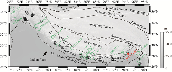
印度与欧亚大陆的相互碰撞挤压形成了世界上海拔最高的喜马拉雅造山带(图 1)(邓起东等, 2002; Yin and Harrison, 2003; Ding et al., 2005),该造山带大地震活动频繁,影响着长达2500 km的人口密集地带.喜马拉雅造山带由一系列断裂带组成,包括主前锋逆冲断裂(Main Frontal Thrust, MFT)、主边界逆冲断裂(Main Boundary Thrust,MBT)、主中央逆冲断裂(Main Central Thrust,MCT)和藏南滑脱带(South Tibet Detachment System,STDS),这些横贯地表的断层在地下汇聚,形成主喜马拉雅逆冲断裂(Main Himalayan Thrust, MHT).这一北倾的大型低角度逆冲滑脱带是大地震的主要发震断层(Avouac et al., 2015; 刘静等, 2015),其几何形态控制着大地震的发生过程和破裂尺度(Bai et al., 2019;Dhakal et al., 2019).
|
图 1 喜马拉雅造山带构造图及历史大地震 绿色和黑色圆圈分别表示喜马拉雅地区历史上发生的MW≥7.0和1964年至今发生的6.0≤MW<7.0的浅源地震(震源深度小于50 km),目录来源于国际地震中心(International Seismological Centre,ISC;http://www.isc.ac.uk)(Willemann and Storchak, 2002).红色星号表示2019年MS6.3墨脱地震.黑色线表示主要缝合带和断裂位置.黑色箭头表示印度板块相对于欧亚板块的运动方向. Fig. 1 Tectonic setting and historical large earthquakes along the Himalaya orogenic belt Green and black circles represent the historical large shallow earthquakes (focal depth less than 50 km) with MW≥7.0 and 6.0≤MW<7.0 since 1964 (International Seismological Center, ISC; http://www.isc.ac.uk) (Willemann and Storchak, 2002), respectively. The red asterisk indicates the 2019 MS6.3 Medog earthquake. The black lines represent major sutures and faults. The black arrow indicates the movement direction of the Indian plate with respect to the Eurasian plate. |
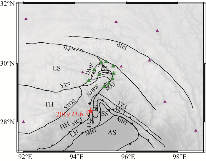
东喜马拉雅构造结(简称东构造结)位于喜马拉雅造山带的东段,被雅鲁藏布江缝合带分割为北部的拉萨地体和南部的南迦巴瓦变质体两部分(Ding et al., 2001)(图 2).近东西向的欧亚大陆边缘在东构造结地区发生了近90°的突然偏转,是两个板块碰撞作用和岩石圈旋转变形最为强烈的地区(Tapponnier et al., 2001; Wang et al., 2014).MBT、MCT和STDS等断裂在该地区也发生了明显的旋转弯曲现象,如MCT在约东经94.4°从东北走向转化为近南北走向,然后在北纬29°附近发生180°拐弯,接着又在北纬28°附近发生180°弯曲,形成了三条平行连通的近南北走向的MCT系统(图 2).北京时间2019年4月24日04时15分,西藏林芝市墨脱县发生MS6.3地震(简称2019年墨脱地震),中国地震台网中心(CENC)给出的震源位置显示,该地震位于南迦巴瓦变质体与桑构造结之间的过渡地带(图 2红色星号所示),周围发育有南北走向的逆冲断裂MCT和MBT以及走滑型图定—因歌断裂(Tuding-Yinge Fault, TYF).该地区构造背景十分复杂,大地震多发,中国有史以来记录到的最大地震——1950年8.6级察隅地震,即发生在邻近地区(图 1)(李保昆等, 2015; 尹凤玲等, 2018; Coudurier-Curveur et al., 2020).
|
图 2 研究区构造背景及台站分布图 红色星号表示2019年墨脱地震.绿色三角形表示中国科学院青藏高原研究所架设的地震台站,棕色三角表示中国数字测震台网地震台站(Zheng et al., 2009).黑线为主要缝合带和断层(Ding et al., 2001),缩写分别是:LS—拉萨地块,NJBW—南迦巴瓦构造结,SS—桑构造结,AS—阿萨姆构造结,TH—特提斯喜马拉雅,HH—高喜马拉雅,LH—低喜马拉雅,YZS—雅鲁藏布江缝合带,BNS—班公湖—怒江缝合带,STDS—藏南拆离带,JSF—嘉黎走滑断裂带,XXL—西兴拉断层,MAF—墨脱—阿尼桥走滑断裂带,DMF—东久—米林走滑断裂带,TYF—图定—因歌走滑断裂,MCT—主中央逆冲断层,MBT—主边界俯冲断层. Fig. 2 The tectonic setting of the study area and the station distribution Red asterisk indicates the 2019 Medog earthquake. Green triangles are broadband seismic stations deployed by the Institute of Tibetan Plateau Research, Chinese Academy of Sciences. Brown triangles are stations from the Chinese Digital Seismic Network (Zheng et al., 2009). Black lines are major sutures and faults (Ding et al., 2001), with the abbreviations: LS—Lhasa block, NJBW—Namche Barwa syntaxis, SS—Sang syntaxis, AS—Assam syntaxis, TH—Tethyan Himalaya, HH—higher Himalaya, LH—lesser Himalaya, YZS—Yarlung Zangbo Suture, BNS—Bangong-Nujiang Suture, STDS—South Tibet Detachment System, JSF—Jiali strike-slip fault, XXL—Xixingla fault, MAF—Medog-Aniqiao strike-slip fault, DMF—Dongjiu-Mainling strike-slip fault, TYF—Tuding-Yinge strike-slip fault, MCT—Main Central Thrust, and MBT—Main Boundary Thrust. |
本研究基于中国科学院青藏高原研究所在东构造结架设的宽频带地震台阵记录的近震波形资料(图 2),结合国内外其他地震台网记录的波形和到时数据,对本次地震的震源位置、震源机制解和震源破裂过程进行重新确定,并对前震和余震的发生进行探测,近震数据的加入有利于获得更加精确的震源信息.结合震源区断层分布和历史中小地震活动性,分析印度大陆俯冲前缘地震活动规律,探讨地震发生的构造背景.
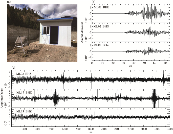
1 数据和方法东构造结地区地理位置和自然环境特殊,固定台站稀疏(图 2),常规地震目录给出的2019年墨脱地震的震源参数差别较大(表 1).自2015年起,中国科学院青藏高原研究所在东构造结安装了宽频带地震台(图 2),对该地区地震、滑坡等相关灾害的发生机理、主要活动断裂的几何形态、以及陆陆板块碰撞前缘地下三维结构进行了深入研究(白玲等,2017;程成等,2017;杨建亚等,2017).图 3显示了地震台站与三分量地震波形的例子,该地震台位于林芝市鲁朗镇藏东南高山环境综合观测研究站(简称藏东南站)(图 3a),距离2019年墨脱地震以北约150 km,实时传输的地震波形上清晰地记录了本次地震的直达P波和S波震相(图 3b).我们同时收集了中国数字测震台网(China Digital Seismic Network, CDSN; http://www.seisdmc.ac.cn)和国际地震学联合研究会(Incorporated Research Institutions for Seismology, IRIS;http://ds.iris.edu)提供的波形数据,选取信噪比高的波形,进行去均值、去仪器响应和滤波等前期处理.地震到时数据主要来源于中国地震台网中心(China Earthquake Network Center, CENC; http://data.earthquake.cn)和美国地质调查局(United States Geological Survey, USGS;https://earthquake.usgs.gov).
|
|
表 1 不同地震目录给出的2019墨脱地震震源参数的比较 Table 1 Comparison of 2019 Medog earthquake source parameters given by different catalogs |
|
图 3 (a) 藏东南站宽频带地震台站照片;(b)藏东南站地震台记录的2019年MS6.3墨脱地震波形,自上至下分别为东西、南北和垂直三个分量;(c)三个不同台站记录的震后1小时连续波形示例 Fig. 3 (a) Photograph of the southeastern Tibet broadband seismic station; (b) The waveforms of the 2019 Medog MS6.3 earthquake recorded by the southeastern Tibet station. Three panels from top to bottom are east-west, north-south and vertical components, respectively; (c) Example waveforms for 1 hour after the 2019 Medog earthquake recorded by three stations |
我们采取四个步骤对2019年墨脱地震的震源参数进行重新确定.第一步,通过拟合远震P波及其深度震相pP波形来确定震源深度(Kikuchi and Kanamori, 1982, 1991; 图 5).当震中距较大时,pP近垂直入射到地表,可以准确确定震源深度.对于浅源地震,P波及其深度震相到时接近,需要对多种震相叠加以后的波形进行拟合(Bai et al., 2017; 白玲等, 2017).震中初始位置和震源机制解来源于全球质心矩张量地震目录(global Centroid-Moment-Tensor, gCMT; https://www.globalcmt.org)(Ekström et al., 2012).由于深度震相pP波形的反射点位于地表,因此波形拟合获得的震源深度为相对于地表的深度.
|
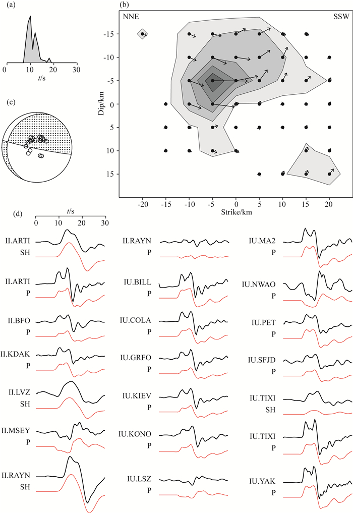
图 5 基于远震P和SH波的震源破裂反演结果 (a)反演的震源时间函数,破裂时间约为15 s;(b)震源破裂过程,坐标(0,0)表示起始破裂点;(c)震源机制解和台站分布(沙滩球中的小圆圈);(d)部分远震波形示例,黑色和红色曲线分别表示观测和理论波形. Fig. 5 Inversion results of source rupture based on teleseismic P and SH waves (a) The source time function, the rupture time is about 15 s; (b) Source rupture process, coordinate (0, 0) is the starting point of the rupture; (c) Focal mechanisms and station distribution (small dots on the beach ball); (d) Example of teleseismic waveforms. The black and red curves are observed and theoretical waveforms, respectively. |
第二步,以波形拟合获得的震源深度为基础,对地震的发震时刻、经纬度和深度进行重新定位.地震重新定位采用的是Hyposat方法(Schweitzer, 2001),其本质是将求解的非线性方程线性化,通过最小二乘原理获得最优解.该方法可以使用不同震中距范围的多种不同类型震相的到时数据,大大增加了使用的数据量.为了获得更加准确的震源深度,我们采用3种方案进行地震定位,一是固定震源深度为远震波形拟合获得的震源深度、二是从第一次迭代开始反演震源深度、三是获得稳定的经纬度后反演震源深度,最后将残差最小的震源位置作为最后定位结果.震源区一维速度模型基于前人不同研究方法的结果获得(Kennett et al., 1995;Laske et al., 2013;程成等,2017),包括上地壳(H<22 km, VP=6.0 km·s-1, VS=3.5 km·s-1)、中地壳(22 km<H<44 km, VP=6.4 km·s-1, VS=3.7 km·s-1)、下地壳(44 km < H < 60 km, VP=7.1 km·s-1, VS=3.9 km·s-1)和地幔(H>60 km, VP=8.0 km·s-1, VS=4.6 km·s-1)四个圈层.
第三步,基于重新确定的发震时刻和震源位置确定震源机制解.2019年墨脱地震位于中-印边界,现有固定台站距离较远,从现有地震目录给出的震源机制解来看(表 1),近南北向的断层面倾角较小,远震体波无法进行很好约束.我们在东构造结架设的宽频带地震台站资料,可以对震源机制解的确定提供新的约束.为此我们采用generalized Cut and Paste (gCAP)(Zhu and Helmberger, 1996)方法对近震及区域尺度波形进行拟合.gCAP方法在CAP法的基础上,增加了各向同性源(ISO)和补偿线性偶极子(CLVD)两个分量.在求解地震的全矩张量解时,将非双力偶分量ISO和CLVD约束为0,以求取地震的最佳双力偶节面解.通过计算理论和实际波形的残差,采用网格搜索得到最小残差的最优解,达到获得最佳震源机制解的目的.
第四步,基于重新确定的发震时刻、震源位置和震源机制解,利用远震P波和S波拟合方法反演地震破裂过程(Kikuchi and Kanamori, 1986,1991,2003;Kikuchi et al., 1993).由于地震发震时刻、震源机制和震源位置之间复杂的权重关系, 震源破裂反演方法经常不稳定.远震波形方位角覆盖好,P波和S波可以有效地分开,在发震时刻、震源位置和震源机制解比较准确的情况下,对于震源时间函数、传播方向、破裂尺度等参数能够提供更加稳定的约束.
此外为了探测墨脱地震可能发生的前震和余震,我们基于东构造结地震台阵和中国数字测震台网下载的近台连续波形数据(图 2),采用REST方法(Thurber et al., 2017)进行了分析.该方法首先基于K90(Kushnir et al., 1990)自动探测和估计可能存在的P和S波震相;然后利用tomoFD法(Roecker et al., 2006)计算理论走时,并计算出可能存在的地震事件;最后基于RT15方法(Rawles and Thurber, 2015)反复迭代并进一步精确估计P和S波到时和地震的空间位置.该方法在近台数据的情况下,可以有效探测震级小于1.0的地震,并且具有快速处理大批量数据的能力.
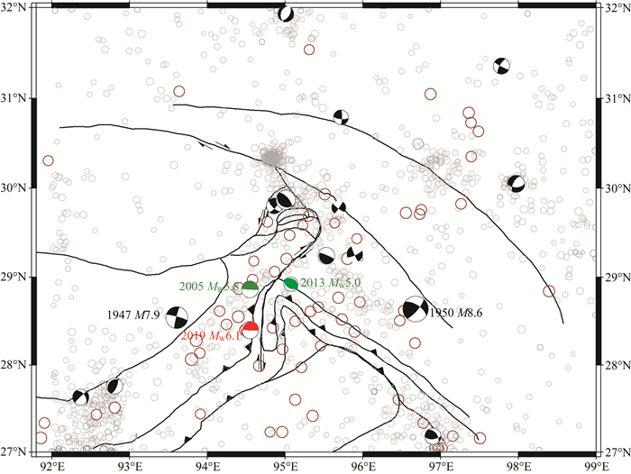
2 结果 2.1 地震定位结果显示,2019年墨脱6.3级地震经纬度为(94.56±0.01°E,28.41±0.01°N),与CENC和gCMT目录给出的参数相比(表 1),更加靠近最西侧的MCT(图 6),与USGS和IPGP(Institute of physics of globe of Paris)(Baillard et al., 2015)的结果具有更好的一致性.震源深度较浅,位于地表以下13.3±1.6(或海平面以下11.5±1.6)km,与USGS和gCMT给出的14 km基本一致.
|
图 6 研究区域主要地震活动 沙滩球表示1947年7.9级地震、1950年8.6级地震和1976年至今MW≥5.0的地震(目录来自gCMT)(Dziewonski et al., 1981; Ekström et al., 2012),棕色大圆圈表示1900至1975年MW≥5.5的地震(来源于USGS),灰色小圆圈表示1964年以来3.0≤MW < 5.0的地震(来源于ISC). Fig. 6 Major earthquakes in the study area The beach balls represent the 1947 M7.9 earthquake, the 1950 M8.6 earthquake and the earthquakes with MW≥5.0 occurred since 1976 (catalog from gCMT) (Dziewonski et al., 1981; Ekström et al., 2012). The large brown circles are earthquakes of MW≥5.5 from 1900 to 1975 (from USGS catalog), while the small gray circles are earthquakes of 3.0≤MW < 5.0 since 1964 (from ISC catalog). |
余震活动可以为震源区断层带精细结构研究提供有利证据.为此我们对2019墨脱地震前3天至后3天的连续波形资料进行了搜索,图 3c列举了三个不同台站记录的震后1 h的连续波形,虽然在单个台站上多次记录到疑似地震信号,但是在相近的不同台站并未清晰地识别到一致性信号,未探测到明显的前震和余震活动.
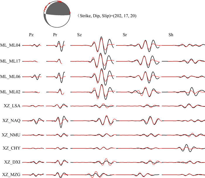
2.2 震源机制解反演基于获得的震源参数信息和近震与区域尺度的波形资料,利用gCAP方法获得了该地震的震源机制解,两个节面的走向/倾角/滑移角分别为202°/17°/20°和93°/84°/106°(表 1),为近南北和近东西方向(图 4),与CENC、gCMT和IPGP给出的震源机制解具有很好的一致性.从震源区构造背景来看,数条断层的分布方向全部为南北向,波形拟合结果进一步表明,采用南北向断层面计算获得的理论与实际观测波形的残差更小,由此可以判断近南北向的节面为主断层面,该断层面以走滑型为主,兼有逆冲成分.
|
图 4 基于近震和区域地震体波的震源机制解反演结果 沙滩球表示得到的震源机制解,沙滩球上的红色符号表示使用的台站.图中曲线表示部分波形的例子,黑色和红色曲线分别表示观测和理论地震波形. Fig. 4 Inversion results of the focal mechanism solution based on body waves recorded by local and regional stations The beach ball indicates the resulting focal mechanism solution, and the red symbols on the beach ball represent the stations. The curves show some of the example data with the black ones for the observed and red ones for theoretical waveforms. |
从波形上可以看出,震源破裂持续时间约为15~20 s,其中在P波之后10 s内有一个明显的波峰,表明破裂分布范围比较集中.波形反演结果可以看到同样的现象,最大破裂沿着低角度的西倾断层面向北北东和断层浅部延伸约5 km(图 5),最大位错约为0.15 m.利用地震矩的计算公式M0=μDA,我们进一步采用剪切模量μ、断层平均位错D和断层面积A三个参数对M0进行了计算,其结果为M0=1.85×10¹⁸Nm,相当于矩震级MW6.1.王卫民等(2019)基于远震P和SH波波形,利用点源模型反演震源机制解,根据反演的震源机制解构建有限断层模型进行震源过程反演,获得的破裂特征与我们的结果具有很好的一致性.
3 讨论与结论由于构造运动、地表快速隆升剥蚀、及印度季风水汽通道等多种因素的影响,东构造结地区地震、冰崩、泥石流等自然灾害发生风险较高.据ISC和USGS目录记载,1964年以来共发生3.0级以上地震1300余次,1900年以来共发生5.5级以上地震81次,其中6.0级以上地震34次,包括1947年MS7.9朗县东南地震(李保昆等, 2014)、1950年MS8.6西藏察隅地震和2017年MS6.9林芝米林地震(白玲等, 2017; Peng et al., 2018; 韦伟等, 2018;尹昕忠等, 2018)(图 6),大地震的发生往往伴随滑坡、泥石流等次生灾害,形成堰塞湖及溃决洪水,给沿岸居民及交通线路构成很大威胁.
印度与欧亚板块的相互碰撞有着绵长的板块边界,不同部位构造背景存在显著差异(白玲等, 2019).喜马拉雅造山带中部尼泊尔地区主要以挤压推覆构造为主.2015年4月25日在尼泊尔廓尔喀地区发生的MW7.8地震,是喜马拉雅造山带板块边界大地震的典型代表.该地震的震中位于MCT附近.MCT和MBT等出露地表的断裂在地下汇聚,形成低角度的MHT这一逆冲滑脱带,是大地震的主要发震断层(Bai et al., 2016, 2019).相比而言,东喜马拉雅构造结不仅发生挤压变形,板块边界在此发生突然偏转,导致该地区同时发生大规模的侧向挤出和旋转变形,构造更加复杂.与此同时,MCT等主要断裂在此发生近90°的突然偏转与两次180°的扭曲变形,形成3条近平行的南北走向MCT断裂带,即南迦巴瓦构造结和桑构造结的过渡带.2019年墨脱地震发生在最西侧的MCT附近(图 6红色沙滩球),该地震节面1的走向为近南北向(表 1),与地表MCT等主要断裂的走向具有很好的一致性.不同研究机构给出的墨脱地震的断层面倾角为10°~17°,以左旋走滑为主,最大破裂位置比较集中,沿着构造走向向北北东传播约5 km.
近年来在2019墨脱地震附近发生了两次5.0级以上地震,分别是2005年MW5.8和2013年MW5.0地震.这两次地震同样位于MCT附近(Engdahl et al., 1998),断层面走向与地表MCT的走向基本一致(图 6绿色沙滩球).综合分析该地区地震的震源参数和尼泊尔喜马拉雅地区的地下结构,我们推断,MCT断裂在东构造结地区发生大规模偏转与扭曲,桑构造结相对于南迦巴瓦构造结向北侧推挤,形成南迦巴瓦与桑构造结的过渡带.同时,MCT在地下向西倾方向发生俯冲,在10 km以下与MBT等断层汇聚形成低角度的MHT,是喜马拉雅造山带大地震的主要发震构造,2019年墨脱6.3级地震,即发生在这一构造背景下.
致谢 两位匿名审稿专家和编辑为本文提供了建设性修改意见.中国地震局地球物理研究所国家台网数据备份中心(doi:10.11998/SeisDmc/SN,http://www.seisdmc.ac.cn)(Zheng et al., 2009)、中国地震台网中心(SEISDMC, doi:10.7914/SN/CB)、USGS (https://earthquake.usgs.gov)和IRIS (http://ds.iris.edu)等机构为本研究提供了波形和到时数据,在此一并表示感谢.
Avouac J P, Meng L S, Wei S J, et al. 2015. Lower edge of locked Main Himalayan Thrust unzipped by the 2015 Gorkha earthquake. Nature Geoscience, 8(9): 708-711. DOI:10.1038/ngeo2518 |
Bai L, Liu H B, Ritsema J, et al. 2016. Faulting structure above the Main Himalayan Thrust as shown by relocated aftershocks of the 2015 MW7.8 Gorkha, Nepal earthquake. Geophysical Research Letters, 43(2): 637-642. DOI:10.1002/2015GL066473 |
Bai L, Li G H, Khan N G, et al. 2017. Focal depths and mechanisms of shallow earthquakes in the Himalayan-Tibetan region. Gondwana Research, 41: 390-399. DOI:10.1016/j.gr.2015.07.009 |
Bai L, Li G H, Song B W. 2017. The source parameters of the M6.9 Mainling, Tibet earthquake and its tectonic implications. Chinese Journal of Geophysics (in Chinese), 60(12): 4956-4963. DOI:10.6038/cjg20171234 |
Bai L, Klemperer S L, Mori J, et al. 2019. Lateral variation of the Main Himalayan Thrust controls the rupture length of the 2015 Gorkha earthquake in Nepal. Science Advances, 5(6): eaav0723. DOI:10.1126/sciadv.aav0723 |
Bai L, Song B W, Li G H, et al. 2019. Seismic activity in the Himalayan orogenic belt and its related geohazards. Advances in Earth Science (in Chinese), 34(6): 629-639. |
Baillard C, Crawford W C, Ballu V, et al. 2015. Seismicity and shallow slab geometry in the central Vanuatu subduction zone. Journal of Geophysical Research:Solid Earth, 120(8): 5606-5623. DOI:10.1002/2014JB011853 |
Cheng C, Bai L, Ding L, et al. 2017. Crustal structure of Eastern Himalayan Syntaxis revealed by receiver function method. Chinese Journal of Geophysics (in Chinese), 60(8): 2969-2979. DOI:10.6038/cjg20170806 |
Coudurier-Curveur A, Tapponnier P, Okal E, et al. 2020. A composite rupture model for the great 1950 Assam earthquake across the cusp of the East Himalayan Syntaxis. Earth and Planetary Science Letters, 531: 115928. DOI:10.1016/j.epsl.2019.115928 |
Dhakal S, Bai L, Neupane B, et al. 2019. Review of earthquake activity and faulting structure in Nepal Himalaya. Bulletin of Nepal Geological Society, 36: 259-266. |
Deng Q D, Zhang P Z, Ran Y K, et al. 2003. Basic characteristics of active tectonics of China. Science in China Series D:Earth Sciences, 46(4): 356-372. |
Ding L, Zhong D L, Yin A, et al. 2001. Cenozoic structural and metamorphic evolution of the eastern Himalayan syntaxis (Namche Barwa). Earth and Planetary Science Letters, 192(3): 423-438. DOI:10.1016/S0012-821X(01)00463-0 |
Ding L, Kapp P, Wan X Q. 2005. Paleocene-Eocene record of ophiolite obduction and initial India-Asia collision, south central Tibet. Tectonics, 24(3): TC3001. DOI:10.1029/2004TC001729 |
Dziewonski A M, Chou T-A, Woodhouse J H. 1981. Determination of earthquake source parameters from waveform data for studies of global and regional seismicity. Journal of Geophysical Research, 86: 2825-2852. DOI:10.1029/JB086iB04p02825 |
Ekström G, Nettles M, Dziewonski A M. 2012. The global CMT project 2004-2010:Centroid-moment tensors for 13, 017 earthquakes. Physics of the Earth and Planetary Interiors, 200-201: 1-9. DOI:10.1016/j.pepi.2012.04.002 |
Engdahl E R, Van Der Hilst R, Buland R. 1998. Global teleseismic earthquake relocation with improved travel times and procedures for depth relocation. Bulletin of the Seismological Society of America, 88(3): 722-743. |
Kennett B L N, Engdahl E R, Buland R. 1995. Constraints on seismic velocities in the Earth from traveltimes. Geophysical Journal International, 122(1): 108-124. DOI:10.1111/j.1365-246X.1995.tb03540.x |
Kikuchi M, Kanamori H. 1986. Inversion of complex body waves-Ⅱ. Physics of the Earth and Planetary Interiors, 43(3): 205-222. DOI:10.1016/0031-9201(86)90048-8 |
Kikuchi M, Kanamori H. 1991. Inversion of complex body waves-Ⅲ. Bulletin of the Seismological Society of America, 81(6): 2335-2350. |
Kikuchi M, Kanamori H, Satake K. 1993. Source complexity of the 1988 Armenian earthquake-Evidence for a slow after-slip event. Journal of Geophysical Research:Solid Earth, 98(B9): 15797-15808. DOI:10.1029/93JB01568 |
Kikuchi M, Kanamori H. 2003. Note on teleseismic body-wave inversion program. http://www.eri.u-tokyo.ac.jp/ETAL/KIKUCHI/.
|
Kushnir A F, Lapshin V M, Pinsky V I, et al. 1990. Statistically optimal event detection using small array data. Bulletin of the Seismological Society of America, 80(6): 1934-1950. |
Laske G, Masters G, Ma Z T, et al. 2013. Update on CRUST1.0-A 1-degree global model of earth's crust.//EGU General Assembly Conference Abstracts. Vienna, Austria: EGU.
|
Li B K, Diao G L, Xu X W, et al. 2015. Redetermination of the source parameters of the Zayü, Tibet M8.6 earthquake sequence in 1950. Chinese Journal of Geophysics (in Chinese), 58(11): 4254-4265. DOI:10.6038/cjg20151130 |
Li B, Diao G, Zou L, et al. 2014. The redetermination of the source parameters of the big earthquake M7.7 in the southeast of Lang County in Tibet in 1947. Seismological and Geomagnetic Observation and Research (in Chinese), 35(1): 85-91. DOI:10.3969/j.issn.1003-3246.2014.01/02.017 |
Liu-Zeng J, Ji C, Zhang J Y, et al. 2015. Tectonic setting and general features of coseismic rupture of the 25 April, 2015 MW 7.8 Gorkha, Nepal earthquake. Chinese Science Bulletin (in Chinese), 60(27): 2640-2655. |
Peng C Y, Yang J S, Wang W P, et al. 2018. The Namche Barwa Temporary Seismic Network (NBTSN) and its application in monitoring the 18 November 2017 M6.9 Mainling, Tibet, China, Earthquake. Seismological Research Letters, 89(5): 1730-1740. DOI:10.1785/0220180001 |
Rawles C, Thurber C. 2015. A non-parametric method for automatic determination of P-wave and S-wave arrival times:application to local micro earthquakes. Geophysical Journal International, 202(2): 1164-1179. DOI:10.1093/gji/ggv218 |
Roecker S, Thurber C, Roberts K, et al. 2006. Refining the image of the San Andreas Fault near Parkfield, California using a finite difference travel time computation technique. Tectonophysics, 426(1-2): 189-205. DOI:10.1016/j.tecto.2006.02.026 |
Schweitzer J. 2001. HYPOSAT-an enhanced routine to locate seismic events. Pure and Applied Geophysics, 158(1-2): 277-289. |
Tapponnier P, Xu Z Q, Roger F, et al. 2001. Oblique stepwise rise and growth of the Tibet plateau. Science, 294(5547): 1671-1677. DOI:10.1126/science.105978 |
Thurber C H, Lanza F, Roecker S W. 2017. Application of a hybrid detection and location scheme to volcanic systems.//AGU Fall Meeting Abstracts. AGU., New Orleans, USA.
|
Wang P, Scherler D, Liu-Zeng J, et al. 2014. Tectonic control of Yarlung Tsangpo Gorge revealed by a buried canyon in Southern Tibet. Science, 346(6212): 978-981. DOI:10.1126/science.1259041 |
Wang W M, He J K, Hao J L, et al. 2019. Preliminary result for rupture process of Apr. 24, 2019, M6.3 earthquake, Motuo, China. (2019-04-25). http://www.itpcas.ac.cn/kycg/yjcg/201904/t20190425_5281509.html.
|
Wei W, Xie C, Zhou B G, et al. 2018. Location of the mainshock and aftershock sequences of the M6.9 Mainling earthquake, Tibet. Chinese Science Bulletin (in Chinese), 63(15): 1493-1501. DOI:10.1360/N972017-01286 |
Willemann R J, Storchak D A. 2002. Data collection at the International Seismological Centre. Seismological Research Letters, 72(4): 440-453. |
Yang J Y, Bai L, Li G H, et al. 2017. Seismicity in the eastern Himalayan syntaxis and its tectonic implications. Recent Developments in World Seismology (in Chinese), (6): 12-18. |
Yin A, Harrison T M. 2003. Geologic evolution of the Himalayan-Tibetan Orogen. Annual Review of Earth and Planetary Sciences, 28: 211-280. |
Yin F L, Han L B, Jiang C S, et al. 2018. Interaction between the 2017 M6.9 Mainling earthquake and the 1950 M8.6 Zayu earthquake and their impacts on surrounding major active faults. Chinese Journal of Geophysics (in Chinese), 61(8): 3185-3197. DOI:10.6038/cjg2018L0761 |
Yin X Z, Zhou B G, Chen J H, et al. 2018. Spatial-temporal distribution characteristics of early aftershocks following the M6.9 Mainling earthquake in Tibet, China. Chinese Journal of Geophysics (in Chinese), 61(6): 2322-2331. DOI:10.6038/cjg2018L0783 |
Zheng X F, Ouyang B, Zhang D N, et al. 2009. Technical system construction of Data Backup Centre for China Seismograph Network and the data support to researches on the Wenchuan earthquake. Chinese Journal of Geophysics (in Chinese), 52(5): 1412-1417. DOI:10.3969/j.issn.0001-5733.2009.05.031 |
Zhu L P, Helmberger D V. 1996. Advancement in source estimation techniques using broadband regional seismograms. Bulletin of the Seismological Society of America, 86(5): 1634-1641. |
白玲, 李国辉, 宋博文. 2017. 2017年西藏米林6.9级地震震源参数及其构造意义. 地球物理学报, 60(12): 4956-4963. DOI:10.6038/cjg20171234 |
白玲, 宋博文, 李国辉, 等. 2019. 喜马拉雅造山带地震活动及其相关地质灾害. 地球科学进展, 34(6): 629-639. |
程成, 白玲, 丁林, 等. 2017. 利用接收函数方法研究喜马拉雅东构造结地区地壳结构. 地球物理学报, 60(8): 2969-2979. DOI:10.6038/cjg20170806 |
邓起东, 张培震, 冉勇康, 等. 2002. 中国活动构造基本特征. 中国科学(D辑), 32(12): 1020-1030. |
李保昆, 刁桂苓, 皱立晔, 等. 2014. 1947年西藏朗县东南M7.7大地震震源参数复核. 地震地磁观测与研究, 35(1): 85-91. DOI:10.3969/j.issn.1003-3246.2014.01/02.017 |
李保昆, 刁桂苓, 徐锡伟, 等. 2015. 1950年西藏察隅M8.6强震序列震源参数复核. 地球物理学报, 58(11): 4254-4265. DOI:10.6038/cjg20151130 |
刘静, 纪晨, 张金玉, 等. 2015. 2015年4月25日尼泊尔MW7.8级地震的孕震构造背景和特征. 科学通报, 60(27): 2640-2655. |
王卫民, 何建坤, 郝金来等. 2019. 2019年4月24日西藏墨脱M6.3级地震震源破裂过程反演初步结果. (2019-04-25). http://www.itpcas.ac.cn/kycg/yjcg/201904/t20190425_5281509.html.
|
韦伟, 谢超, 周本刚, 等. 2018. 西藏米林M6.9级地震及其余震序列地震定位. 科学通报, 63(15): 1493-1501. DOI:10.1360/N972017-01286 |
杨建亚, 白玲, 李国辉, 等. 2017. 东喜马拉雅构造结地区地震活动及其构造意义. 国际地震动态, (6): 12-18. DOI:10.3969/j.issn.0253-4975.2017.06.004 |
尹凤玲, 韩立波, 蒋长胜, 等. 2018. 2017年米林6.9级地震与1950年察隅8.6级地震的关系及两次地震对周边活动断层的影响. 地球物理学报, 61(8): 3185-3197. DOI:10.6038/cjg2018L0761 |
尹昕忠, 周本刚, 陈九辉, 等. 2018. 西藏米林M6 9地震早期余震时空分布特征. 地球物理学报, 61(6): 2322-2331. DOI:10.6038/cjg2018L0783 |
郑秀芬, 欧阳飚, 张东宁, 等. 2009. "国家测震台网数据备份中心"技术系统建设及其对汶川大地震研究的数据支撑. 地球物理学报, 52(5): 1412-1417. DOI:10.3969/j.issn.0001-5733.2009.05.031 |
 2020, Vol. 63


