2. 国土资源部应用地球物理重点实验室, 长春 130026;
3. 油页岩地下原位转化与钻采技术国家地方联合工程实验室, 长春 130026;
4. 吉林大学应用地球物理实验教学中心, 长春 130026;
5. 吉林大学地质资源立体探测虚拟仿真实验教学示范中心, 长春 130026
2. Key Laboratory of Applied Geophysics, Changchun 130026, China;
3. National-Local Joint Engineering Laboratory of In-situ Conversion, Drilling and Exploitation Technology for Oil Shale, Changchun 130026, China;
4. Central Lab of Applied Geophysics, Changchun 130026, China;
5. Virtual Simulation Experiment Teaching Center of Stereo-Exploration of Geological Resources, Changchun 130026, China
中国东北地区主体夹持于西伯利亚克拉通、中朝克拉通与西太平洋板块之间,其东部为被西太平洋增生带所包围的一系列拼贴而成的微陆块.在古生代期间,东北地区的构造演化主要受西伯利亚克拉通与华北克拉通之间的古亚洲洋构造系演化的影响,以众多微陆块之间的碰撞-拼合和古亚洲洋的最终闭合为主要特征.自中生代以来,东北地区又经历了中-新生代环太平洋构造体系与中生代蒙古-鄂霍茨克构造体系的双重叠加和改造.东北亚大陆边缘中新生代的构造演化主要受到西太平洋板块向欧亚大陆岩石圈下大规模的多期次、多角度深俯冲作用的影响(唐克东等,2004).
大兴安岭西部地区构造演化受蒙古-鄂霍茨克构造带作用为主,太平洋构造域作用为辅:随着鄂霍茨克洋盆关闭和晚侏罗世-早白垩世伊泽奈奇板块与东北亚大陆之间发生左旋走滑-弧后伸展,东北亚此阶段发育多条大规模的北北东向左旋走滑断裂系,并伴随大规模的火山活动(王鸿祯和莫宣学,1996;葛肖虹等,2009).在此动力学背景下,形成中生代陆内裂谷系火山-断陷盆地群,发育时代由西向东变新,鄂霍茨克洋盆关闭的挤压作用对本区火山-断陷盆地群的早期发育也具有重要作用(董树文等,2008).软流圈上涌,引起岩石圈伸展减薄,穹窿、伸展与火山作用广泛分布(单玄龙等,2009;李江海等,2013).太平洋构造域作用:朱夏(1983)认为西太平洋构造域的西边界为大兴安岭重力梯级带,并指出西太平洋构造域向西方向的作用延伸至大兴安岭重力梯级带,表明大兴安岭西部地区不受西太平洋构造域的影响.佳蒙地块-鄂霍茨克闭合和太平洋板块的共同作用:中国东北地区地处西伯利亚和华北两大古板块和太平洋板块所挟持的构造区域内(李锦轶等,2009),区内发育有以松辽盆地为代表的一系列中-新生代含油气盆地(邵济安等,2005;Zhou et al., 2009).许文良等(2013)通过火山作用的研究认为东北亚构造演化受鄂霍茨克构造带、太平洋板块和印度板块三种作用影响.二连、海拉尔盆地受印度板块向北俯冲以及太平洋板块向西俯冲的影响(李德生,1982;Yang and Liu, 2013).综上所述,对于东北亚地区尤其是大兴安岭西部地区的构造演化的认识仍有较大的争议.
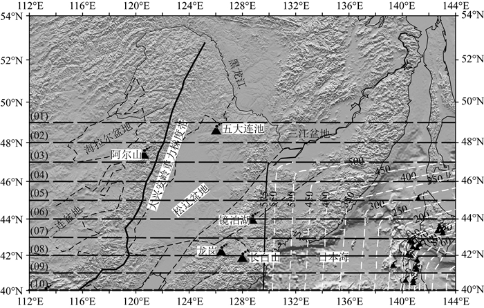
大兴安岭重力梯度带是东北地区最为显著的地质特征(图 1).该重力梯度带两侧在布格重力异常值、地壳与岩石圈厚度、地幔地震波速度等方面都存在着巨大的差异.Xu(2007)针对太行山重力梯度带研究认为,华北岩石圈减薄过程的时空差异性是重力梯度带形成的主要动力学机制,但该模式并不能很好地解释大兴安岭重力梯度带的形成机制,因为东北地区的岩石圈减薄时间可能要早于华北地区,或者是华北岩石圈的减薄程度可能要大于东北地区(于宋月等,2007).杨宝俊等(2005)综合7条地学断面资料,提出壳幔物质的密度不均匀性和莫霍界面的起伏是形成大兴安岭重力梯度带的主要原因.然而这些人工源地震测深剖面探测深度较浅,所提供的地球物理信息对于理解整个大兴安岭重力梯度带的形成机制及其动力学演化仍是略显不足.Liu等(2017)根据古海底年龄数据重建了俯冲板块的岩石圈年龄,认为地幔转换带中滞留板片都是不早于30 Ma形成的,是促使东亚大陆新生代的破坏以及板内火山形成的主要因素.
|
图 1 研究区构造简图 黑色三角为火山;白色虚线为西向俯冲太平洋板块的上边界;黑色虚线为P波速度扰动剖面位置图. Fig. 1 Tectonic map of the study area Black triangles denote the volcanoes; White dash lines present upper boundary of the Pacific plate; Black dash lines present position of ten vertical cross sections of P-wave tomography. |
新生代以来,中国东北地区受西太平洋板块俯冲和由此而引起的弧后伸展运动影响,形成了以松辽断陷盆地为主、盆岭相间的北东向大陆裂谷系(刘嘉麒,1988).伴随着新生代大陆裂谷运动,该区发生强烈的火山活动,其主要产物为碱性及强碱性玄武岩(Xu et al., 2009b);玄武岩作为地幔部分熔融的产物,对了解深部地幔构造演化过程有着重要的意义.
众多地震成像的结果显示在大兴安岭—太行山重力梯度带以东的地幔转换带内分布着大规模的高速异常体,这通常被解释为停滞的西太平洋俯冲板片(Ai et al., 2003; Zhao,2004; Lei and Zhao, 2005; Huang and Zhao, 2006; 田有等,2011;Wei et al., 2012);而且地幔转换带内停滞的板片前缘位置大致与大兴安岭—太行山重力梯度带相对应(Huang and Zhao, 2006),在重力梯度带以西地区也还未发现有大规模的高速异常体存在.这是否表明大兴安岭—太行山重力梯度带的形成与西太平洋板块的俯冲作用有着直接的关系?且西太平洋板块向欧亚大陆下的深俯冲前缘并未超过重力梯度带?地震层析成像技术是研究地球深部结构非常有力的手段,它能够很好地刻画地球内部的三维速度结构.所以本研究收集了中国东北、华北地区以及韩国、日本等部分台网所接收的近震和远震的到时数据,利用近震远震走时数据联合反演的方法获得了东北地区精细的壳幔三维P波速度结构,这为探讨西太平洋俯冲板块对中国东北构造演化的影响研究提供了高分辨率的三维速度模型.
1 数据资料与成像方法本研究中使用了区域地震绝对走时与远震相对走时残差两部分数据进行地震层析成像联合反演.
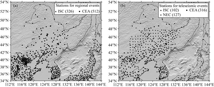
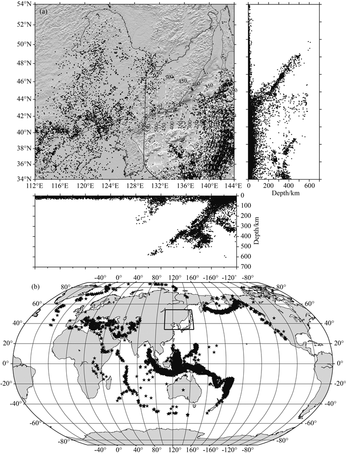
在近震数据中收集了1980—2016年间中国地震台网,2000—2013年间ISC台网观测到的P波到时数据.由于中国地震台网和ISC地震报告中存在相同的地震事件,我们事先对这两组数据进行了合并以剔除重复的部分.为了能够在十几万个区域地震中筛选出最好的数据以用于层析成像反演,在挑选数据时遵循以下准则:(1)将模型空间分成0.2°×0.2°×5 km的块体;(2)从每个立方体中挑出P波走时最多、地震定位精度最高的地震事件(定位的深度误差小于5 km);(3)每个被挑选的地震事件必须有10条以上的P波到时;(4)理论走时与实际走时之差小于3.0 s.最终,本研究收集了由中国地震台网512个台站接收的1980到2016年间6584个近震事件的42463条P波走时数据以及ISC 326个台站接收的2000—2013年间4942个近震事件的80101条P波走时数据,近震台站及事件如图 2a和图 3a所示.
|
图 2 研究所用接收近震数据的台站(a)及接收远震数据的台站(b)分布图 Fig. 2 Distribution of stations record regional earthquakes (a) and teleseismic events (b) used in the study |
|
图 3 研究所用近震(a)及远震(b)分布图 Fig. 3 Distribution of regional earthquakes (a) and teleseismic events (b) used in the study |
在远震数据中,本研究收集了1980—2005年间中国地震台网316个台站、2000—2013年间ISC台网102个台站以及2009—2011年间NECESSArray台网127个台站观测到的5677个远震事件,震中距均大于30°,小于90°.选择的远震至少有10个走时,共计68945个远震相对走时残差数据应用于最终的反演.相对走时残差的计算详见Zhao等(1994),远震台站及事件如图 2b和图 3b所示.
本研究采用了Zhao等(1992)提出的射线追踪方法.该方法是在Um和Thurber(1987)提出的伪弯曲射线追踪算法的基础上做了改进,使之能够适用于存在复杂速度间断面的情况.在上述提到的两种射线追踪方法中,都引入了一个常量-增强因子以加速射线追踪算法的收敛;在本研究中我们依据费马原理针对不同震中距、不同震源深度的射线采用不同的增强因子,使射线追踪结果更加准确.在IASP91速度模型下(Kennett and Engdahl, 1991),利用改进后的射线追踪方法得到的走时与Taup软件(Crotwell et al., 1999)计算的走时之差小于0.02 s.IASP91模型作为层析成像反演所用的一维初始速度模型;在模型空间设置了三维网格节点,水平方向上的节点间距为1°,在深度方向上共设置了15个界面,深度分别为10.0, 22.0, 50.0, 80.0, 160.0 km, 240.0, 320.0, 400.0, 480.0, 560.0, 640.0, 720.0 km, 800.0, 900.0, 1000.0 km.鉴于LSMR算法(Fong and Saunders, 2011)相比传统的LSQR算法(Paige and Saunders, 1982)收敛更快、更稳定,在反演计算中,利用LSMR算法完成最终的模型求解.利用大量高质量的地震数据,我们获得了中国东北地区横向分辨率可达100 km的速度模型.
2 分辨率分析与成像结果我们采用检测板分辨率测试(Zhao et al., 1992)来评估反演结果的好坏.首先在模型格点处设置正负相间的3%的速度扰动,然后在该模型中根据真实的台站、震源位置计算理论走时,并在计算理论走时过程中加入标准差为0.1 s的随机误差,用以模拟拾取地震走时的误差.再在一维速度模型下计算理论走时,对两者的残差进行层析成像反演,将反演的模型与初始模型相比较.若反演结果与初始模型在数值属性和数值大小上吻合较好,则表明该区域的分辨率较高.从分辨率测试结果上看(图 4),研究目标区均具有很好的分辨,表明该研究的水平向成像分辨率达到了80~100 km之间,部分区域甚至更高.

|
图 4 8个深度层上分辨率检测结果 Fig. 4 Checker board resolution results in eight layers |
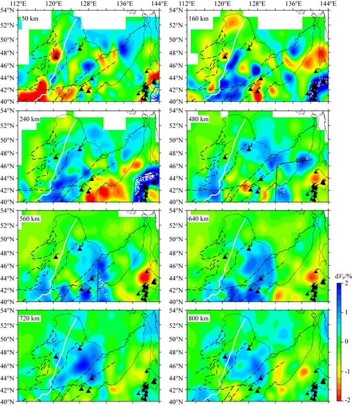
本研究以地球一维速度模型IASP91为初始参考模型,采用走时层析成像的方法反演获得高分辨率P波速度结构,各个深度层面的成像结果如图 5所示.成像结果总体显示在中国东北地区火山下方的上地幔内以低速异常为主,西向俯冲的太平洋板块显示为显著的高速异常.在地幔转换带(410~660 km)内,东北地区以高速异常为主,推测为水平滞留在该区域的西向俯冲的太平洋板块,但该显著的高速异常水平延伸至大兴安岭重力梯度带东缘附近截止.大兴安岭重力梯度带及其西部地区以低速异常为主.
|
图 5 8个典型深度上的P波速度层析成像结果 红色和蓝色分别表示低速和高速,黑色三角为火山. Fig. 5 Plan views of P-wave tomography at eight typical depth slices Red and blue colors denote slow and fast velocity anomalies (in %); the black triangles denote the volcanoes |
众多研究表明中国东北地区的构造演化与古亚洲洋、蒙古—鄂霍茨克洋闭合以及西向俯冲的太平洋板块密切有关,但之前的地震层析成像研究更多的围绕太平洋板块对大兴安岭东部地区盆地形成与演化、火山起源等问题的展开,并未详细探讨俯冲的太平洋板块差异及其对于大兴安岭重力梯度带与西部地区盆地群域构造形成、演化的影响.为了探讨上述科学问题,本研究展示了多个垂直速度剖面.垂直剖面位置见图 1,其速度结构剖面如图 6所示.

|
图 6 10个典型垂直剖面的P波速度异常图;剖面位置见图 1 红色和蓝色分别表示低速和高速;红色三角为火山;白点为地震;黑色箭头表示大兴安岭重力梯级带位置. Fig. 6 Ten typical vertical cross sections of P-wave tomography along profiles shown in Fig. 1 Red and blue colors denote slow and fast velocity anomalies (in %); The red triangles denote the volcanoes. White dots show the earthquakes; Black arrows denote the Da Hinggan Mountains Gravity lineament. |
西太平洋板块大概是于晚三叠纪或早侏罗纪开始向欧亚大陆下俯冲(Xu et al., 2009a; Zhou et al., 2014; Safonova and Santosh, 2014; Wilde, 2015).自中生代以来,西太平洋板块的俯冲方向、速度和角度一直随时间发生着较大的变化(例如,Engebretson et al., 1985; Maruyama et al., 1997; Koppers et al., 2001; Sun et al., 2007).在140~125, 125~110, 110~100, 100~80, 80~43和43~0 Ma期间,西太平板块大致的俯冲方向依次为NNE, WNW, WSW, NW,NNW和WNW(Koppers et al., 2001).也有学者提出是在50 Ma左右,西太平洋板块的俯冲方向从NNW向大幅度调整为WNW向(Sharp and Clague, 2006).众多全球和区域地震层析成像研究表明俯冲的西太平板片已经进入了地幔转换带,在中国华北、东北的南部停滞在660 km界面之上(Zhao, 2004; Huang and Zhao, 2006; Li and van der Hilst, 2010; Wei et al., 2012, 2015; Fukao and Obayashi, 2013; Chen et al., 2017).接收函数的研究结果显示在中国东北发现660 km界面强烈下沉,而在中朝克拉通并未发现有660 km界面下沉的迹象(Zhang et al., 2016).在此之前的很多地震学研究也揭示了,在中国东北地区存在660 km界面轻微或显著下沉的情况(Li and Yuan, 2003; Ai et al., 2003; Li et al., 2008, 2013; Ye et al., 2011; Liu and Zhou, 2015).
图 6的速度结构剖面显示,显著高速异常的西太平洋俯冲板片以近30°的倾角向中国东北下方俯冲,深俯冲板片中伴随着众多的深源地震,形成非常明显的Wadati-Benioff带.在中朝克拉通下的地幔转换带中,西太平洋板片停滞在660 km界面之上,这与之前众多的层析成像的结果相吻合.但在中国东北地区的北部(43°N以北),俯冲板片已经开始插入下地幔,这与许多接收函数的结果非常吻合(Li and Yuan, 2003; Ai et al., 2003; Liu and Zhou, 2015; Zhang et al., 2016).考虑到在约43 Ma西太平洋的俯冲方向从NNW调整为WNW向,我们认为西太平洋板块起初向中国东北俯冲,然后才开始向中朝克拉通之下俯冲,在俯冲的过程中,由于西太平洋板块大角度地调整了俯冲方向,致使中国东北之下的660 km界面充当了西太平洋板块转向过程中的承重点,当660 km界面承载较大的压力,迫使该界面大面积下沉,最终导致部分俯冲板片穿过地幔转换带,进入了下地幔.
3.2 中国东北地区火山活动与太平洋俯冲板块长白山火山是东北亚地区最大的活火山,位于中国与朝鲜边境(图 1).大量地震层析成像的结果揭示,在长白山火山下面存在异常显著的低速异常,但该异常的详细特征目前仍不清楚.部分全球和区域地震层析成像给出的低速异常只达到300 km深(e.g., Zhao, 2004; Huang and Zhao, 2006; Wei et al., 2012), 但也有学者认为长白山火山之下的低速异常可达至410 km深(Lei and Zhao, 2005; Zhao et al., 2009; Li and Van Der Hilst, 2010; Zhao and Tian, 2013; Takeuchi et al., 2014; Wei et al., 2015; Tian et al., 2016; Chen et al., 2017).
最近Tang等(2014)利用布设在中国东北地区的NECESSArray台阵的数据反演了中国东北地区地壳上地幔的P波和S波速度结构,成像结果显示在俯冲残余板块内部存在低速异常,该异常可能由来自下地幔的热物质引起,由此他们提出长白山火山的起源可能与来自下地幔的热物质和板片洞有关.但是最近的层析成像结果并未发现在俯冲板块内部可能存在热物质上涌通道的证据(Takeuchi et al., 2014; Wei et al., 2015).相对之前众多学者给出的地震层析成像结果,我们的地震层析成像结果在地幔楔里有更好的分辨率,因而能够更加精细地刻画深部异常体的三维结构.从图 6可以看出,西太平洋板块从日本海沟开始向下俯冲,在地幔转换带中停滞在660km界面之上,在长白山火山之下明显的低速异常从地幔转换带和大地幔楔(Zhao et al., 2009; Zhao and Tian, 2013)连续上涌至地表.Tian等(2016)也揭示在长白山火山之下410 km界面存在大规模的下沉,这被认为由于地幔转换带中有热物质上涌所致.我们的结果显示,在中国东北之下的大地幔楔中,较热的地幔物质上涌与中国东北新生代的火山有较好的对应关系.结合全球与区域地震层析成像所给出的模型,我们认为大地幔楔中的地幔对流在长白山火山和中国东北其他火山的形成演化过程中有着至关重要的作用.
3.3 太平洋俯冲板块对大兴安岭重力梯度带及西部盆地的影响作为一条极其重要的纵贯中国大陆的构造线,重力梯度带将中国大陆划分为东西两大构造单元(例如,Griffin et al., 1998; Xu,2007).西太平洋板块大致是在晚三叠或早侏罗纪开始向欧亚大陆俯冲,而重力梯度带是在早白垩纪开始形成.Xu(2007)认为西太平洋板块在中国东部的俯冲造成华北克拉通东部块体与西部块体差异性的岩石圈减薄是形成重力梯度带的重要原因.后期,西太平洋俯冲板片在地幔转换带中的停滞并在大地幔楔内又引起了较大规模的对流,进一步促进了重力梯度带的形成.Huang和Zhao(2006)认为在大地幔楔中由于板片俯冲引起地幔流和深部板片脱水引起了较热、较湿的软流圈物质的上涌,导致中国东部的岩石圈减薄,形成了重力梯度带.
从图 6的速度结构剖面可以看出西太平洋俯冲板片的前缘位置基本与大兴安岭重力梯度带的位置相吻合,在重力梯度带以西的区域也并未发现有明显的高速异常体的存在,可以得出判断:西太平洋俯冲板片已经到达了中国东北腹地,但是并未越过大兴安岭,而俯冲作用是否影响大兴安岭西部地区仍需进一步讨论.在大地幔楔中也发现有大规模低速异常体,我们推测这应该是由于在板片的深俯冲过程中,从深部地幔对流上来的幔源物质.这些幔源物质具有较高的密度,导致重力梯度带以东的区域主体呈现为较大的正的重力异常.
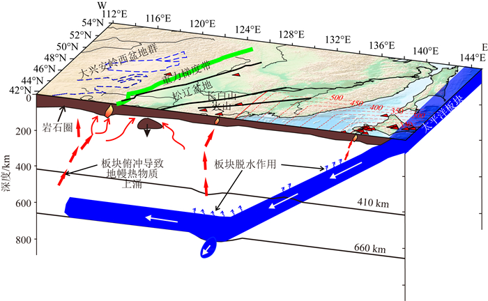
根据地震层析成像结果,我们给出了中国东北地区构造模型图(图 7).表明高速俯冲的太平洋板块主体并未穿透660 km间断面,而是水平停滞在地幔转换带内,不排除部分板块由于大量堆积而沉入下地幔;俯冲板片内的含水矿物或断层再活动等引起的深部脱水作用和大地幔楔内的对流循环造成部分熔融热物质上涌的深部过程,可能是导致东北亚板内火山(长白山)和大陆裂谷(松辽盆地)形成的主要原因;在松辽盆地下方上地幔内表现为显著的高速异常体表明可能存在岩石圈拆沉作用;太平洋板块前缘已到达大兴安岭重力梯级带附近,板块前端引起的上升地幔热流对于大兴安岭重力梯级带的形成与后期演化可能起到关键的作用.
|
图 7 中国东北地区构造模型图 红色虚线表示太平洋板块上边界;红色三角为火山;绿线表示大兴安岭重力梯度带;黑色实线表示主干断层;蓝色虚线表示大兴安岭西部盆地. Fig. 7 A cartoon showing the main features of the upper-mantle structure under Northeast China Red dash lines denote the upper boundaries of the Pacific plate; Red triangle denote volcanoes. Green line denotes the Da Hinggan Mountains Gravity lineament. Black liens denote major faults. Blue dash lines denote basins in the west of the Da Hinggan Mountains Gravity lineament. |
基于大量的近震到时数据和远震相对走时残差数据反演了中国东北及华北部分地区三维P波速度结构,根据反演结果推测西太平洋俯冲板片已经到达了中国东北腹地,前缘抵达大兴安岭重力梯级带附近.
针对该地区深部构造演化得到了以下几点认识:
(1) 高分辨率的三维地震层析成像结果表明,西太平洋板块在中国东北北部由于俯冲转向的原因部分已经穿过地幔转换进入了下地幔,而在中国华北地区俯冲板片停滞在660 km界面之上,这说明西太平洋板块的俯冲作用对中国东北和中国华北的构造演化有着极大的差异;
(2) 中国东北地区的新生代火山的成因与西太平洋板块的俯冲有着密切的关联,而不是深地幔柱型的“热点”火山;
(3) 西太平洋俯冲板块的俯冲前缘并未穿过大兴安岭,但重力梯度带的形成、演化与西太平洋板块俯冲所引起的地幔楔内的地幔对流有关,深部幔源物质上涌,致使重力梯度带以东的区域呈现正的重力异常.
致谢 特别感谢日本东北大学赵大鹏教授提供的地震层析成像计算程序(TOMOG3D).感谢两位评审专家提出的宝贵修改意见和建议,同时感谢中国国家地震局数据中心提供的地震走时数据(郑秀芬等,2009).本文中部分图件采用GMT软件绘制(Wessel and Smith,1998).
Ai Y S, Zheng T Y, Xu W W, et al. 2003. A complex 660 km discontinuity beneath northeast China. Earth and Planetary Science Letters, 212(1-2): 63-71. DOI:10.1016/S0012-821X(03)00266-8 |
Chen C X, Zhao D P, Tian Y, et al. 2017. Mantle transition zone, stagnant slab and intraplate volcanism in Northeast Asia. Geophysical Journal International, 209(1): 68-85. |
Crotwell H P, Owens T J, Ritsema J. 1999. The TauP Toolkit:Flexible seismic travel-time and ray-path utilities. Seismological Research Letters, 70(2): 154-160. DOI:10.1785/gssrl.70.2.154 |
Dong S W, Zhang Y Q, Chen X H, et al. 2008. The formation and deformational characteristics of East Asia multi-direction convergent tectonic system in late Jurassic. Acta Geoscientica Sinica (in Chinese), 29(3): 306-317. |
Engebretson D, Cox A, Gordon R G. 1985. Relative motions between oceanic and continental plates in the Pacific Basin. Special Paper of the Geological Society of America, 206(9): 1-59. |
Fong D C L, Saunders M. 2011. LSMR:An iterative algorithm for sparse least-squares problems. SIAM Journal on Scientific Computing, 33(5): 2950-2971. DOI:10.1137/10079687X |
Fukao Y, Obayashi M. 2013. Subducted slabs stagnant above, penetrating through, and trapped below the 660 km discontinuity. Journal of Geophysical Research:Solid Earth, 118(11): 5920-5938. DOI:10.1002/2013JB010466 |
Ge X H, Ma W P, Liu J L, et al. 2009. A discussion on the tectonic framework of Chinese mainland. Geology in China (in Chinese), 36(5): 949-965. |
Griffin W L, Zhang A D, O'Reilly S Y, et al. 1998. Phanerozoic evolution of the lithosphere beneath the Sino-Korean Craton.//Mantle Dynamics and Plate Interactions in East Asia. Washington D C: Geodynamics Series, 27: 107-126 https://agupubs.onlinelibrary.wiley.com/doi/abs/10.1029/GD027p0107
|
Huang J L, Zhao D P. 2006. High-resolution mantle tomography of China and surrounding regions. Journal of Geophysical Research:Solid Earth, 111(B9): B09305. DOI:10.1029/2005JB004066 |
Kennett B L N, Engdahl E R. 1991. Traveltimes for global earthquake location and phase identification. Geophysical Journal International, 105(2): 429-465. DOI:10.1111/gji.1991.105.issue-2 |
Koppers A A P, Morgan J P, Morgan J W, et al. 2001. Testing the fixed hotspot hypothesis using 40Ar/39Ar age progressions along seamount trails. Earth and Planetary Science Letters, 185(3-4): 237-252. DOI:10.1016/S0012-821X(00)00387-3 |
Lei J S, Zhao D P. 2005. P-wave tomography and origin of the Changbai intraplate volcano in Northeast Asia. Tectonophysics, 397(3-4): 281-295. DOI:10.1016/j.tecto.2004.12.009 |
Li C, Van Der Hilst R D. 2010. Structure of the upper mantle and transition zone beneath Southeast Asia from traveltime tomography. Journal of Geophysical Research:Solid Earth, 115(B7): B07308. DOI:10.1029/2009JB006882 |
Li D S. 1982. Tectonic types of oil and gas basins in China. Acta Petrolei Sinica (in Chinese), 3(3): 1-12. |
Li J, Chen Q F, Vanacore E, et al. 2008. Topography of the 660-km discontinuity beneath northeast China:Implications for a retrograde motion of the subducting Pacific slab. Geophysical Research Letters, 35(1): L01302. DOI:10.1029/2007GL031658 |
Li J, Wang X, Wang X J, et al. 2013. P and SH velocity structure in the upper mantle beneath Northeast China:Evidence for a stagnant slab in hydrous mantle transition zone. Earth and Planetary Science Letters, 367: 71-81. DOI:10.1016/j.epsl.2013.02.026 |
Li J H, Li W B, Wang H H, et al. 2013. Kinematic analysis of plate collision during the assembly of Pangea in Late Paleozoic. Geological Review (in Chinese), 59(6): 1043-1059. |
Li J Y, Zhang J, Yang T N, et al. 2009. Crustal tectonic division and evolution of the southern part of the north Asian Orogenic region and its adjacent areas. Journal of Jilin University (Earth Science Edition) (in Chinese), 39(4): 584-605. |
Li X Q, Yuan X H. 2003. Receiver functions in northeast China-Implications for slab penetration into the lower mantle in Northwest Pacific subduction zone. Earth and Planetary Science Letters, 216(4): 679-691. DOI:10.1016/S0012-821X(03)00555-7 |
Liu L J, Zhou Q. 2015. Deep recycling of oceanic asthenosphere material during subduction. Geophysical Research Letters, 42(7): 2204-2211. DOI:10.1002/2015GL063633 |
Liu X, Zhao D P, Li S Z, et al. 2017. Age of the subducting Pacific slab beneath East Asia and its geodynamic implications. Earth and Planetary Science Letters, 464: 166-174. DOI:10.1016/j.epsl.2017.02.024 |
Maruyama S, Isozaki Y, Kimura G, et al. 1997. Paleogeographic maps of the Japanese Islands:Plate tectonic synthesis from 750 Ma to the present. Island Arc, 6(1): 121-142. DOI:10.1111/iar.1997.6.issue-1 |
Paige C C, Saunders M A. 1982. LSQR:An algorithm for sparse linear equations and sparse least squares. ACM Transactions on Mathematical Software, 8(1): 43-71. DOI:10.1145/355984.355989 |
Safonova I Y, Santosh M. 2014. Accretionary complexes in the Asia-Pacific region:Tracing archives of ocean plate stratigraphy and tracking mantle plumes. Gondwana Research, 25(1): 126-158. DOI:10.1016/j.gr.2012.10.008 |
Shan X L, Gao X, Xu H L. 2012. The main factors of intermediate and mafic volcanic gas reservoir forming of Yingcheng formation in Anda area of Songliao basin. Journal of Jilin University (Earth Science Edition) (in Chinese), 42(5): 1348-1357. |
Shao J A, Zhang L Q, Xiao Q H, et al. 2005. Rising of da Hinggan Mts in Mesozoic:A possible mechanism of intracontinental orogeny. Acta Petrologica Sinica (in Chinese), 23(1): 789-794. |
Sharp W D, Clague D A. 2006. 50-Ma initiation of Hawaiian-Emperor bend records major change in Pacific plate motion. Science, 313(5791): 1281-1284. DOI:10.1126/science.1128489 |
Sun W D, Ding X, Hu Y H, et al. 2007. The golden transformation of the Cretaceous plate subduction in the West Pacific. Earth and Planetary Science Letters, 262(3-4): 533-542. |
Takeuchi N, Kawakatsu H, Tanaka S, et al. 2014. Upper mantle tomography in the northwestern Pacific region using triplicated P waves. Journal of Geophysical Research:Solid Earth, 119(10): 7667-7685. DOI:10.1002/2014JB011161 |
Tang K D, Shao J A, Li J C, et al. 2004. Nature of the Yanbian suture zone and structure of Northeast Asia. Geological Bulletin of China (in Chinese), 23(9-10): 885-891. |
Tian Y, Liu C, Feng X. 2011. P-wave velocity structure of crust and upper mantle in Northeast China and its control on the formation of mineral and energy. Chinese Journal of Geophysics (in Chinese), 54(2): 407-414. DOI:10.3969/j.issn.0001-5733.2011.02.017 |
Tian Y, Zhu H X, Zhao D P, et al. 2016. Mantle transition zone structure beneath the Changbai volcano:Insight into deep slab dehydration and hot upwelling near the 410 km discontinuity. Journal of Geophysical Research:Solid Earth, 121(8): 5794-5808. DOI:10.1002/2016JB012959 |
Um J, Thurber C. 1987. A fast algorithm for two-point seismic ray tracing. Bulletin of the Seismological Society of America, 77(3): 972-986. |
Wei W, Xu J D, Zhao D P, et al. 2012. East Asia mantle tomography:New insight into plate subduction and intraplate volcanism. Journal of Asian Earth Sciences, 60: 88-103. DOI:10.1016/j.jseaes.2012.08.001 |
Wei W, Zhao D P, Xu J D, et al. 2015. P and S wave tomography and anisotropy in Northwest Pacific and East Asia:Constraints on stagnant slab and intraplate volcanism. Journal of Geophysical Research:Solid Earth, 12(3): 1642-1666. DOI:10.1002/2014JB011254 |
Wessel P, Smith W H F. 1998. New, improved version of Generic Mapping Tools released. EOS, 79(47): 579. DOI:10.1029/98EO00426 |
Wilde S A. 2015. Final amalgamation of the Central Asian Orogenic Belt in NE China:Paleo-Asian Ocean closure versus Paleo-Pacific plate subduction-A review of the evidence. Tectonophysics, 662: 345-362. DOI:10.1016/j.tecto.2015.05.006 |
Xu W L, Ji W Q, Pei F P, et al. 2009b. Triassic volcanism in eastern Heilongjiang and Jilin provinces, NE China:Chronology, geochemistry, and tectonic implications. Journal of Asian Earth Sciences, 34(3): 392-402. DOI:10.1016/j.jseaes.2008.07.001 |
Xu W L, Xu Y G. 2007. Diachronous lithospheric thinning of the North China Craton and formation of the Daxin'anling-Taihangshan gravity lineament. Lithos, 96(1-2): 281-298. DOI:10.1016/j.lithos.2006.09.013 |
Xu Y G, Li H Y, Pang C J, et al. 2009a. On the timing and duration of the destruction of the North China Craton. Chinese Science Bulletin, 54(19): 3379-3396. |
Yang B J, Liu W S, Wang X C, et al. 2005. Geophysical characteristics of Daxinganling gravitational gradient zone in the East China and its geodynamic mechanism. Chinese Journal of Geophysics (in Chinese), 48(1): 86-97. |
Yang Y Q, Liu M. 2013. The Indo-Asian continental collision:A 3-D viscous model. Tectonophysics, 606: 198-211. DOI:10.1016/j.tecto.2013.06.032 |
Ye L L, Li J, Tseng T L, et al. 2011. A stagnant slab in a water-bearing mantle transition zone beneath northeast China:Implications from regional SH waveform modelling. Geophysical Journal International, 186(2): 706-710. DOI:10.1111/j.1365-246X.2011.05063.x |
Yu S Y, Xu Y G, Huang X L, et al. 2007. Comparison of composition and thermal state of the upper mantle beneath northeast and north China:Implications for lithospheric thinning in eastern China. Acta Petrologica Sinica (in Chinese), 23(6): 1252-1268. |
Zhang R Q, Gao Z Y, Wu Q J, et al. 2016. Seismic images of the mantle transition zone beneath Northeast China and the Sino-Korean craton from P-wave receiver functions. Tectonophysics, 675: 159-167. DOI:10.1016/j.tecto.2016.03.002 |
Zhao D P, Hasegawa A, Horiuchi S. 1992. Tomographic imaging of P and S wave velocity structure beneath northeastern Japan. Journal of Geophysical Research:Solid Earth, 97(B13): 19909-19928. DOI:10.1029/92JB00603 |
Zhao D P, Hasegawa A, Kanamori H. 1994. Deep structure of Japan subduction zone as derived from local, regional, and teleseismic events. Journal of Geophysical Research:Solid Earth, 99(B11): 22313-22329. DOI:10.1029/94JB01149 |
Zhao D P. 2004. Global tomographic images of mantle plumes and subducting slabs:Insight into deep Earth dynamics. Physics of the Earth and Planetary Interiors, 146(1-2): 3-34. DOI:10.1016/j.pepi.2003.07.032 |
Zhao D P, Tian Y, Lei J S, et al. 2009. Seismic image and origin of the Changbai intraplate volcano in East Asia:Role of big mantle wedge above the stagnant Pacific slab. Physics of the Earth and Planetary Interiors, 173(3-4): 197-206. DOI:10.1016/j.pepi.2008.11.009 |
Zhao D P, Tian Y. 2013. Changbai intraplate volcanism and deep earthquakes in East Asia:A possible link?. Geophysical Journal International, 195(2): 706-724. DOI:10.1093/gji/ggt289 |
Zheng X F, Ouyang B, Zhang D N, et al. 2009. Technical system construction of Data Backup Centre for China Seismograph Network and the data support to researches on the Wenchuan earthquake. Chinese Journal of Geophysics (in Chinese), 52(5): 1412-1417. DOI:10.3969/j.issn.0001-5733.2009.05.031 |
Zheng X F, Yao Z X, Liang J H, et al. 2010. The role played and opportunities provided by IGP DMC of China National Seismic Network in Wenchuan earthquake disaster relief and researches. Bulletin of the Seismological Society of America, 100(5B): 2866-2872. DOI:10.1785/0120090257 |
Zhou J B, Wilde S A, Zhang X Z, et al. 2009. The onset of Pacific margin accretion in NE China:Evidence from the Heilongjiang high-pressure metamorphic belt. Tectonophysics, 478(3-4): 230-246. DOI:10.1016/j.tecto.2009.08.009 |
Zhou J B, Cao J L, Wilde S, et al. 2014. Paleo-Pacific subduction-accretion:Evidence from Geochemical and U-Pb zircon dating of the Nadanhada accretionary complex, NE China. Tectonics, 33(12): 2444-2466. DOI:10.1002/2014TC003637 |
Zhu X, Chen H J, Sun Z C, et al. 1983. The Mesozoic-Cenozoic tectonics and petroliferous basins of China. Acta Geological Sinica (in Chinese), (3): 235-242. |
董树文, 张岳桥, 陈宣华, 等. 2008. 晚侏罗世东亚多向汇聚构造体系的形成与变形特征. 地球学报, 29(3): 306-317. DOI:10.3321/j.issn:1006-3021.2008.03.005 |
葛肖虹, 马文璞, 刘俊来, 等. 2009. 对中国大陆构造格架的讨论. 中国地质, 36(5): 949-965. DOI:10.3969/j.issn.1000-3657.2009.05.001 |
李德生. 1982. 中国含油气盆地的构造类型. 石油学报, 3(3): 1-12. |
李江海, 李维波, 王洪浩, 等. 2013. 晚古生代泛大陆聚合过程中板块碰撞的运动学分析. 地质论评, 59(6): 1043-1059. |
李锦轶, 张进, 杨天南, 等. 2009. 北亚造山区南部及其毗邻地区地壳构造分区与构造演化. 吉林大学学报(地球科学版), 39(4): 584-605. |
刘嘉麒. 1988. 中国东北地区新生代火山幕. 岩石学报, 4(1): 1-10. DOI:10.3321/j.issn:1000-0569.1988.01.001 |
邵济安, 张履桥, 肖庆辉, 等. 2005. 中生代大兴安岭的隆起-一种可能的陆内造山机制. 岩石学报, 23(1): 789-794. |
唐克东, 邵济安, 李景春, 等. 2004. 吉林延边缝合带的性质与东北亚构造. 地质通报, 23(9-10): 885-891. |
田有, 刘财, 冯晅. 2011. 中国东北地区地壳、上地幔速度结构及其对矿产能源形成的控制作用. 地球物理学报, 54(2): 407-414. DOI:10.3969/j.issn.0001-5733.2011.02.017 |
许文良, 王枫, 裴福萍, 等. 2013. 中国东北中生代构造体制及其区域成矿背景:来自中生代火山岩组合时空变化的制约. 岩石学报, 30(2): 339-353. |
杨宝俊, 刘万崧, 王喜臣, 等. 2005. 中国东部大兴安岭重力梯级带域地球物理场特征及其成因. 地球物理学报, 48(1): 86-97. DOI:10.3321/j.issn:0001-5733.2005.01.014 |
于宋月, 徐义刚, 黄小龙, 等. 2007. 东北和华北地区上地幔成分和热状态对比及对中国东部岩石圈减薄的启示. 岩石学报, 23(6): 1252-1268. DOI:10.3969/j.issn.1000-0569.2007.06.003 |
郑秀芬, 欧阳飚, 张东宁, 等. 2009. "国家数字测震台网数据备份中心"技术系统建设及其对汶川大地震研究的数据支撑. 地球物理学报, 52(5): 1412-1417. DOI:10.3969/j.issn.0001-5733.2009.05.031 |
朱夏, 陈焕疆, 孙肇才, 等. 1983. 中国中、新生代构造与含油气盆地. 地质学报, (3): 235-242. |
 2019, Vol. 62


