2. 中国地震局地球物理研究所, 北京 100081
2. Key Laboratory of Seismic Observation and Geophysical Imaging, Institute of Geophysics, China Administration of Earthquake, Beijing 100081, China
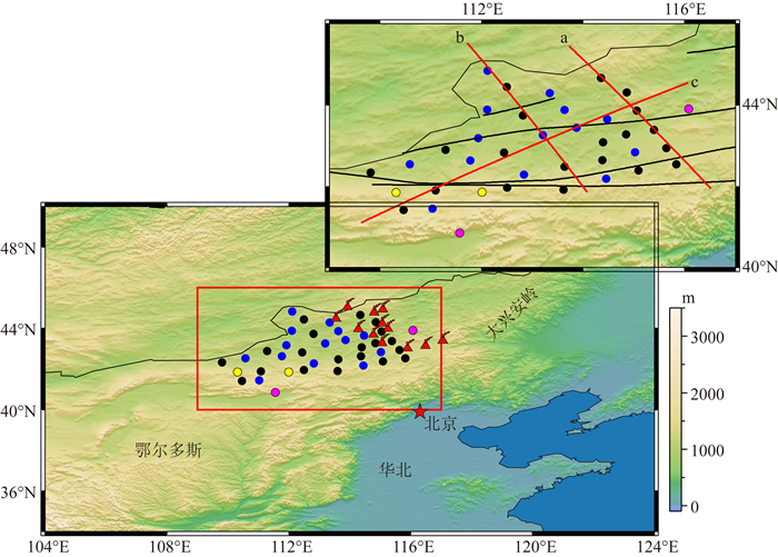
本文研究区位于华北克拉通北缘的兴蒙造山带,比邻中蒙边境(图 1),属于中亚造山带的东段.中亚造山带是西伯利亚克拉通与塔里木—中朝克拉通之间的古亚洲洋消减所形成的由一系列岛弧、蛇绿岩带、海岛、增生楔以及微陆板块等组成的规模宏大的造山带(Badarch et al., 2002; Xiao et al., 2003; Windley et al., 2007),并伴随着大量的花岗状岩浆岩的侵入(Jahn et al., 2000).该区是古亚洲洋闭合的最终位置,地壳形变复杂、板内火山活动强烈,中国东部第四纪火山数最多的阿巴嘎火山群位于区内,是研究欧亚大陆东缘形成和演化过程以及新生代板内火山活动机制的理想场所.
|
图 1 研究区域概况与台站分布 红色框内为本研究的研究区域.虚线为国界线.紫色圆点为中国数字地震台网(CDSN)的XLT和HHC 2个台站.其余圆点为NM台阵分布位置,其中蓝色圆点的台站配备的是CMG-3ESPC地震计,黑色圆点的台站配备的是Trillium-120PA地震计,黄色圆点的台站是港震BBVS-60地震计.红色三角形为火山位置.黑色实线为缝合线和断裂,从北到南依次为二连浩特—贺根山蛇绿岩带、索伦山缝合带、西拉木伦缝合带以及赤峰—白云鄂博断裂.表标有a, b, c字母的红色实线为图 6中的CCP叠加剖面. Fig. 1 Study area and the distribution of seismic stations Red rectangle box shows our study area. Dashed line is the international bounder between China and Mongolia. Purple circles are the seismic stations of XLY and HHC from China Digital Seismograph Network (CDSN). The other circles are the locations of NM seismic array. Blue circles are the seismic stations equipped with CMG-3ESPC sensor and Reftek-130B data acquisition unit. Black circles are the seismic stations equipped with Trillium-120PA sensor. Yellow circles are the seismic stations equipped with BBVS-60 sensor. Red triangles are volcanoes. Black lines are suture lines and fault, which are Erenhot-hegenshan ophiolite belt, Solonker suture, Xilamulun suture and Bayan Obo-Chifeng fault. Red lines, marked with the character a, b and c, represent the location of CCP stacking profiles. |
兴蒙造山带的蛇绿岩带、高压蓝片岩以及与俯冲碰撞有关的火山深成岩带等一系列的证据,反映了该区自显生宙以来先后经历了古亚洲洋的俯冲消亡、陆陆板块的持续碰撞拼合以及碰撞后的区域伸展作用等一系列复杂的地质构造过程(Sengör et al., 1993; Jahn et al., 2000; Xiao et al., 2003, 2014; Jahn, 2004).蛇绿岩被认为是板块碰撞后大洋岩石圈的残留,是确定古板块边界以及板块最终闭合时间的重要证据.兴蒙造山带存在三条蛇绿岩带,在阿巴嘎地区都有较好的出露,由北向南依次是二连浩特—贺根山蛇绿岩带、索伦山缝合带以及西拉木伦缝合带(黄金香等, 2006).根据该区的地质、地球化学以及地磁等信息,前人对该区的构造演化过程提出了多种模型(Sengör et al., 1993; Badarch et al., 2002; Xiao et al., 2003; Kröner et al., 2007; Jian et al., 2008; Chen et al., 2009; Xu et al., 2013; Wu et al., 2016).这些模型看法不一,差异较大,对古亚洲洋最终闭合的时间、缝合带的空间分布位置、区域展布对地壳的改造过程等仍存在诸多争议.
进入新生代以来,兴蒙造山带发育了一系列断续延伸约上千公里的火山群,北起大兴安岭诺敏河火山,经阿尔山、阿巴嘎,南至乌兰哈达火山群.阿巴嘎火山群,位于中蒙边境,与蒙古高原的达里甘嘎火山连接,是东亚地区第四纪火山玄武岩分布面积最广、火山数量最多的板内火山群(白志达等, 2012),也是中国东部最大且了解甚少的新生代晚期的内陆火山活动地区之一(Ho et al., 2008).一些研究显示,兴蒙造山带的板内火山形成与太平洋俯冲板块有关(如Wang et al., 2015等).区域内的岩石圈构造与火山活动关系密切(Ho et al., 2008).地质、地球化学研究(Ho et al., 2008)发现该地区板内火山随着时间由西北向东南推移,玄武岩的年代也逐渐年轻.Barry和Kent(1998)发现中亚造山带地区广泛分布的新生代玄武岩具有相似的地球化学性质,表明这些玄武岩可能具有相同的地幔源以及岩浆形成过程(Barry et al., 2003).而过量的Nb和Ta元素含量(Guo et al., 2016a)以及橄榄岩中低的18O同位素含量(Wang et al., 2015)暗示着岩浆源中含有俯冲洋壳组分,且玄武岩富含不相容元素的特征表示其岩浆源与低质量分数的熔融交代体相似(Guo et al., 2016a),推测与地幔转换带中残留的古太平洋板块的脱水熔融引起的地幔物质折返有关(Wang et al., 2015; Guo et al., 2016a).另一些研究则显示兴蒙造山带板内火山形成与地幔物质上涌有关.Windley和Allen(1993)根据蒙古高原地质、玄武岩分布和热流值等研究结果认为新生代火山活动是地幔柱与其上覆岩石圈相互作用的结果.Smith(2013)认为沿亚洲板块边缘俯冲的太平洋和印度板块可能阻挡了地幔物质的上涌流动,从而仅在板块俯冲前端即亚洲板块下方形成了一个小尺度的软流圈对流,板内火山的形成可能归因于软流圈对流以及岩石圈下部的拆沉等作用.
兴蒙造山带虽有地震探测研究,但主要集中在华北及其北部邻区(武岩等, 2011; Wang et al., 2016; 王桥和黄清华,2016)、兴蒙造山带东部的中国东北地区(张风雪等, 2013; 张广成等, 2013; Tao et al., 2014; Zhang et al., 2014a; 潘佳铁等, 2014a; Guo et al., 2015)以及蒙古中部地区(何静等, 2014; 余大新等, 2015, 2016; He et al., 2016, 2017; Qiang et al., 2017; Zhang et al., 2017),仅有少数剖面延伸到了兴蒙造山带的阿巴嘎地区.白登海等(1993)在内蒙东部赤峰—东乌旗开展了大地电法探测研究.2009—2010年中国地质科学院在怀来—二连—中蒙边界进行了近630 km的地震反射、三分量反射、宽频带地震观测以及宽角反射与折射联合探测实验, 穿过了本研究区,但并未经过阿巴嘎火山(Zhang et al., 2014b; 李文辉等, 2014; 李英康等, 2014; 龚辰等, 2016).接收函数剖面(龚辰等, 2016)显示Moho面产状沿索伦缝合带南缘呈对称轴关系,认为古亚洲洋沿索伦缝合带南缘双向俯冲闭合(Zhang et al., 2014b; 龚辰等, 2016).近几年利用NECESSArray数据对兴蒙造山带地区的壳幔结构也进行了一系列的研究(Tao et al., 2014; Guo et al., 2015; Liu et al., 2016, 2017), 认为长白山下的地幔热物质上涌和松辽盆地下方上地幔物质的下沉,形成了一个岩石圈下的局部对流系统.而松辽盆地下方的下降流可能在其西部的阿巴嘎和海拉尔火山地区进一步导致了二级次生的局部地幔上涌(Guo et al., 2016c).但是NECESSArray台阵位于阿巴嘎火山群的边缘地区,对阿巴嘎地区板内火山的形成提供的约束有限.因而在该区开展地壳结构研究对于理解兴蒙造山带的构造演化以及认识阿巴嘎火山乃至兴蒙造山带的板内火山成因具有重要意义.
本文利用最近布设的覆盖三条缝合线的36个地震流动观测台阵观测到的数据,结合中国地震台网的2个固定台数据,采用接收函数方法获得阿巴嘎火山群及其邻区的地壳厚度与波速比信息,为研究兴蒙造山带的形成演化和火山成因提供约束.
1 数据与方法本研究所用到的数据包含两部分:一部分是受国家自然科学基金资助,中国地震局地球物理研究所于2013年1月—2015年07月在内蒙阿巴嘎—中蒙边境地区布设的36套(NM台阵)地震流动观测台阵记录的远震数据;另一部分是在IRIS上下载的中国数字地震台网(CDSN)XLT和HHC 2个台站(图 1中紫色圆圈)2009年4月到2015年6月的远震数据.图 1中蓝色、黑色和黄色圆圈所示台站分别配备CMG-3ESPC,Trillium-120PA以及港震BBVS-60地震计.
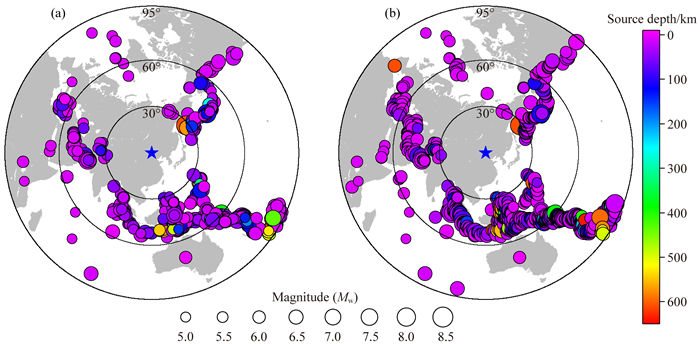
本文选取震中距为30°~95°,震级大于5.5的远震事件,采用接收函数方法,研究地壳的厚度、波速比和Moho的起伏.截取P波到时的前50 s到后150 s地震波形数据,并对数据进行去倾斜、去均值、重采样,带通滤波(0.05~2 Hz)等处理.挑选出初动P波清晰、三分量齐全且垂向分量衰减快的地震事件,采用时间域反褶积方法来计算接收函数,且对每一个台站的接收函数进行人工挑选.最终在NM台阵,挑选出了593个远震事件,XLT和HHC台共挑选出640个远震事件,总计1108个地震事件,地震事件很好地覆盖了研究区的各个方位(图 2).
|
图 2 远震事件分布图 (a) NM台阵所用到的593个远震事件分布图;(b) XLT和HHC台所用到的640个远震事件分布图.五角星为研究区域所在的位置. Fig. 2 Teleseismic event locations used in this study (a) The distribution of 593 teleseismic earthquakes used by NM array; (b) The distribution of 640 teleseismic earthquakes used by XLT and HHC stations. Five-pointed star is the location of study area. |
远震P波可认为是近似垂直入射,且携带着震源、传播路径以及台站下方结构等信息.Phinney(1964)提出了谱振幅比法来消除震源及传播路径对远震P波波形的影响,Langston(1979)在此基础上提出了等效震源的方法并引入水准量来获得稳定的接收函数.Ligorría和Ammon(1999)在前人的基础上将频谱域的接收函数发展到了时间域.本研究采用时间域反褶积的方法来计算接收函数,选取的高斯系数为2.5.
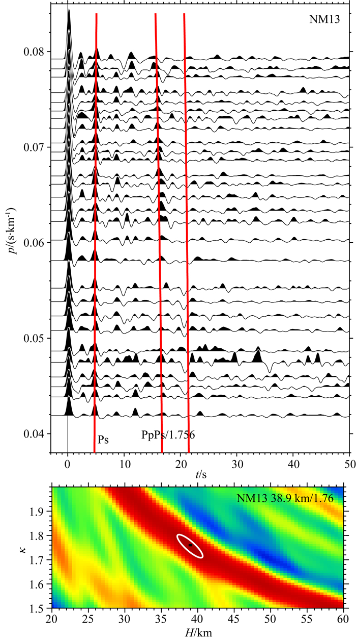
当直达P波穿过速度间断面Moho面时会产生一系列的转换震相如Ps,PpPs,以及PpSs+PsPs波. Zhu和Kanamori(2000)利用给定的地壳平均P波速度以及转换震相与直达P波的到时差获得了地壳厚度(H)与平均波速度(κ)的函数(图 3).在H-κ域下,每个H和κ都对应着一个关于各个转换波的到时,在一定范围内对H和κ进行扫描,通过加权叠加每个H-κ对应到时下的接收函数振幅:

|
(1) |
|
图 3 q13号台叠加后的接收函数以及H-κ扫描叠加结果 Fig. 3 Receiver functions after stacking and the H-κ stacking result at station 13 |
其中r表示在不同震相到时下的振幅.振幅S(H, κ)最大处一般对应着H和κ的最优解,这种方法被称为H-κ叠加.地壳厚度和波速比的方差分别为σH2=2σS/(∂2S/∂H2)和σκ2=2σS/(∂2S/∂κ2),其中σS为叠加过程中S(H, κ)的估计方差.在H-κ扫描叠加过程中,地壳的平均速度选自研究区人工源宽角反射剖面探测结果(Li et al., 2013a, 李英康等, 2014),设为6.3 km·s-1,地壳厚度H的变化范围为20~60 km,κ的变化范围为1.5~2.0.计算中三个震相Ps,PpPs以及PpSs+PsPs的叠加加权系数ω1, ω2, ω3分别为0.7, 0.2, 0.1.
我们还采用共转换点叠加(CCP)(Dueker and Sheehan, 1997; Zhu, 2000)的方法获得地壳Moho界面的产状和起伏形态.将研究区间进行网格划分,根据背景速度模型通过射线追踪和时深转换将接收函数上每一个振幅点转换到相应深度网格内,视为相应深度网格上的转换波,对每一个网格内所有接收函数的振幅值进行叠加,这样就可以凸显弱的转换震相、压制多次波,从而提高了信噪比.叠加区域大小以及背景速度模型影响着共转换点叠加成像结果的分辨率及精度.叠加区域的大小控制了单元网格内参与叠加的接收函数数目.叠加区域越大,叠加的转换点就越多,弱的转换波信号可以被有效增强而凸显出来,缺点是降低了横向分辨率.为此,依据衍射理论,叠加区域的大小常由深度z处的第一菲涅尔半径确定.
2 结果本研究38个台站中有32个台站能够利用H-κ扫描叠加方法获得较为可靠的地壳厚度和波速比值(表 1),其中有3个台站由于数据较少而没法获得有效的结果(NM20、NM30、NM31),另外3个台站由于受松散沉积物的严重影响计算出来的H-κ结果可信度较低(NM15、NM28、NM35).
|
|
表 1 H-κ扫描叠加方法获得的地壳厚度以及波速比值 Table 1 Crustal thickness and Vp/Vs ratio obtained from H-κ stacking method |
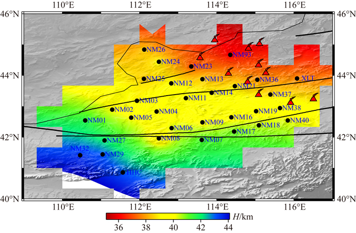
研究结果显示该地区Moho面所产生的Ps震相的到时大致为4.3~5.6 s,地壳厚度在35~44 km内,平均值约为40 km.整体上研究区西南地区地壳厚度较厚,东北地区较薄(图 4),其中阿巴嘎火山群地区的地壳厚度明显变薄,而索伦缝合带以南的地区地壳厚度相对较厚.本文结果与前人在该地区用接收函数所获得的结果具有很好的一致性.结合该区域及邻区前期的接收函数研究成果(Tao et al., 2014; 何静等, 2014; He et al., 2016; 龚辰等, 2016),华北克拉通的鄂尔多斯盆地周边地区地壳厚度较厚,索伦缝合带以北的阿巴嘎火山群地区地壳较薄.
|
图 4 地壳厚度分布图 Fig. 4 Illustration of crustal thickness values obtained from H-κ stacking |
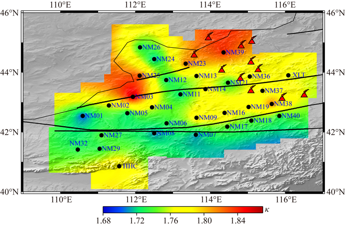
研究区台站下方平均的地壳波速比值介于1.70~1.87之间,平均值为1.76(图 5),略低于全球大陆的平均值1.78(Zandt and Ammon, 1995),略高于蒙古中南部地区的波速比值1.74(He et al., 2016).研究区东部阿巴嘎火山地区的波速比值相对较高.NM03台下的高波速比可能与台站下的沉积层有关.本区波速比值分布图与前人H-κ扫描叠加方法的结果基本相当(龚辰等, 2016).
|
图 5 波速比值分布图 Fig. 5 Vp/Vs ratios |
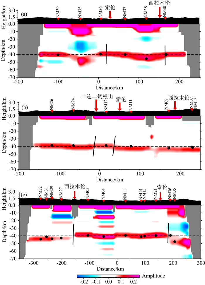
CCP叠加结果如图 6所示.图 1中的红色实线为图 6所示剖面的相应位置,图 6(a,b,c)分别为以ISAP91为速度结构的CCP叠加结果.接收函数CCP叠加与H-κ扫描叠加方法获得地壳厚度结果有很好的一致性.二连浩特—贺根山、索伦以及西拉木伦三条缝合线穿越了研究区,从CCP叠加剖面中可以明显地看出,Moho面在缝合线附近都存在较显著的变化,表明缝合线应该是岩石圈层次的.阿巴嘎火山地区的NM35台站30 km深度和38号台站15 km深度附近存在明显的负振幅异常,暗示着低速异常体的存在(图 6a).
|
图 6 CCP叠加结果图 a—c剖面的位置与图 1中a—c剖面相对应,反三角形为台站所在位置,箭头为缝合线和断层的位置,黑色圆点为H-κ扫描叠加方法获得的地壳厚度值. Fig. 6 Profiles from CCP stacking The a—c profiles are correlate to the a—c profiles in Fig. 1. Reverse triangles are the locations of stations. Arrows represent the suture lines and faults. Black dots are the crustal thickness obtained from H-κ stacking method. |
详细的地壳结构有助于了解地壳的起源、演化、现今构造活动等信息.地壳的厚度与物质组成是研究地壳起源和演化的基本参数.地壳的增厚或减薄与地壳在挤压或拉张下的构造变形有着直接的关系,而地壳的平均波速比则与地壳的组分、温度(年龄)、含水量等因素有关.波速比值主要对SiO2的含量较敏感(Lowry and Pérez-Gussinyé, 2011).随着SiO2矿物含量的增大,波速比值变小(Christensen, 1996; Zandt and Ammon, 1995),反之随着铁镁质含量的增高而增大.波速比值从酸性花岗岩(硅铝质)的1.71增加到基性辉长岩(铁镁质)的1.87(Tarkov and Vavakin, 1982).前人的研究(Lowry and Pérez-Gussinyé, 2011)发现花岗岩类基岩地区的波速比值较低,如爱达荷州以及沿海花岗基岩地区、内达华山脉和巴哈基岩的东部地区等,而富含铁镁质的火山地区波速比值较高,如长白山、大同火山等(张广成等,2013; 高延光和李永华,2014).地壳厚度和地壳波速比值的关系可能暗示着大陆地壳构造演化的重要信息(嵇少丞等, 2009).嵇少丞等(2009)根据不同的地壳厚度和波速比关系提出了不同的流变学构造模式,以研究和约束大陆地壳的构造演化.
本文采用接收函数方法对兴蒙造山带地区的地壳结构进行了研究.接收函数H-κ扫描叠加方法获得的地壳厚度与人工深地震测深在该区所获得的地壳厚度具有很好的一致性(~ 40 km)(李文辉等, 2014; 李英康等, 2014),但整体上低于全球造山带的平均地壳厚度(Christensen and Mooney, 1995).索伦缝合线和西拉木伦缝合线将研究区分为三部分:兴蒙造山带、过渡区以及华北北缘,从表 1中可以看出,从兴蒙造山带到华北北缘地壳平均厚度逐渐增加,而地壳的平均波速比值则逐渐减小,减小的幅度不是特别显著.CCP叠加结果(图 6)显示兴蒙造山带的地壳界面变化较平缓.从图 6a, 6b, 6c所示、沿不同方向或位置展布的剖面上可以看出,Moho面在二连浩特—贺根山、索伦以及西拉木伦缝合线附近均出现颇为明显的变化,需要特别强调指出的是,图 6a所示剖面穿过阿巴嘎火山区,Moho面在索伦缝合线附近没有明显的变化,可能是由于后期的火山活动对该区的Moho进行了强烈的改造.在西拉木伦缝合带以南的华北北缘地区,Moho面相对较深且变化增大.
研究区普遍分布着古、中生代的花岗岩(Wu et al., 2003a, b;童英等,2010).我们所揭示的波速比值较低的地区大体对应于童英等(2010)所总结的花岗岩分布区,全球其他花岗岩类基岩地区也均表现为波速比值较低的特征(Lowry and Pérez-Gussinyé, 2011).兴蒙造山带整体较薄的地壳和较低的波速比值可能存在两种形成机制.一种可能是与造山后拆沉作用有关.童英等(2010)通过总结研究区内形成于拉张环境下的碱性(A型)花岗岩的时空分布情况,认为该区存在泥盆、二叠、三叠纪和晚中生代四期伸展作用,且认为前三期伸展作用可能与古生代古亚洲洋最终关闭后的造山后伸展作用(石玉若等, 2007; 童英等, 2010)或与造山作用后期可能的岩石圈拆沉有关(邵济安等, 1994),而晚中生代花岗岩的形成晚于西伯利亚造山带和中朝板块缝合的时限,且可能与华北地区的中生代花岗岩具有相同的成因,与岩石圈的拆沉、东北亚地区大规模的伸展有关(童英等, 2010).拆沉作用之所以导致造山区地壳的减薄和波速比的降低,是因为增厚的造山由于重力的不稳定性,导致下地壳铁镁质物质被拆沉剥离,引起花岗岩浆活动并造成地壳整体成分向长英质方向演化.一般情况下,拆沉作用会引起火山活动,地表出露玄武岩,如青藏高原(Bird, 1978)和科罗拉多高原地区(Bird, 1979).兴蒙造山带地区的西拉木伦缝合带附近出露有中生代玄武岩(Wu et al., 2011),为岩石圈拆沉提供了岩石学证据.除了拆沉作用外,另一种导致波速比值降低的可能机制是,中、新生代以来,包括中亚造山带东段在内的整个中国东部整体处于拉张环境(Meng, 2003),下地壳韧性变形强度低,比上地壳更容易显著减薄,从而使得地壳整体上富含长英质成分.这两种机制都可以解释为什么兴蒙造山带地区的地壳厚度相对全球造山带来说比较薄且Moho面较平缓,也能进一步解释兴蒙造山带整体较低的波速比值(何静等, 2014; Tao et al., 2014; Guo et al., 2015; He et al., 2016).深地震测深剖面(Zhang et al., 2014b)结果显示上地壳呈现较高的速度,而下地壳呈现低速、低速度梯度的特征(李文辉等, 2014),认为可能是由于上地壳大面积花岗岩出露的原因.已有的噪声与面波联合反演(Liu et al., 2017)以及噪声与接收函数联合反演(Guo et al., 2015)等地震成像结果(Li et al., 2012, 2013b; 潘佳铁等, 2014a, b)也显示研究区上地壳的速度较高,而中下地壳存在低速异常.下地壳的低速可能是下地壳富含长英质(Guo et al., 2015)或者是下地壳韧性变形强度低的反映.这些证据也进一步支持我们的推论.
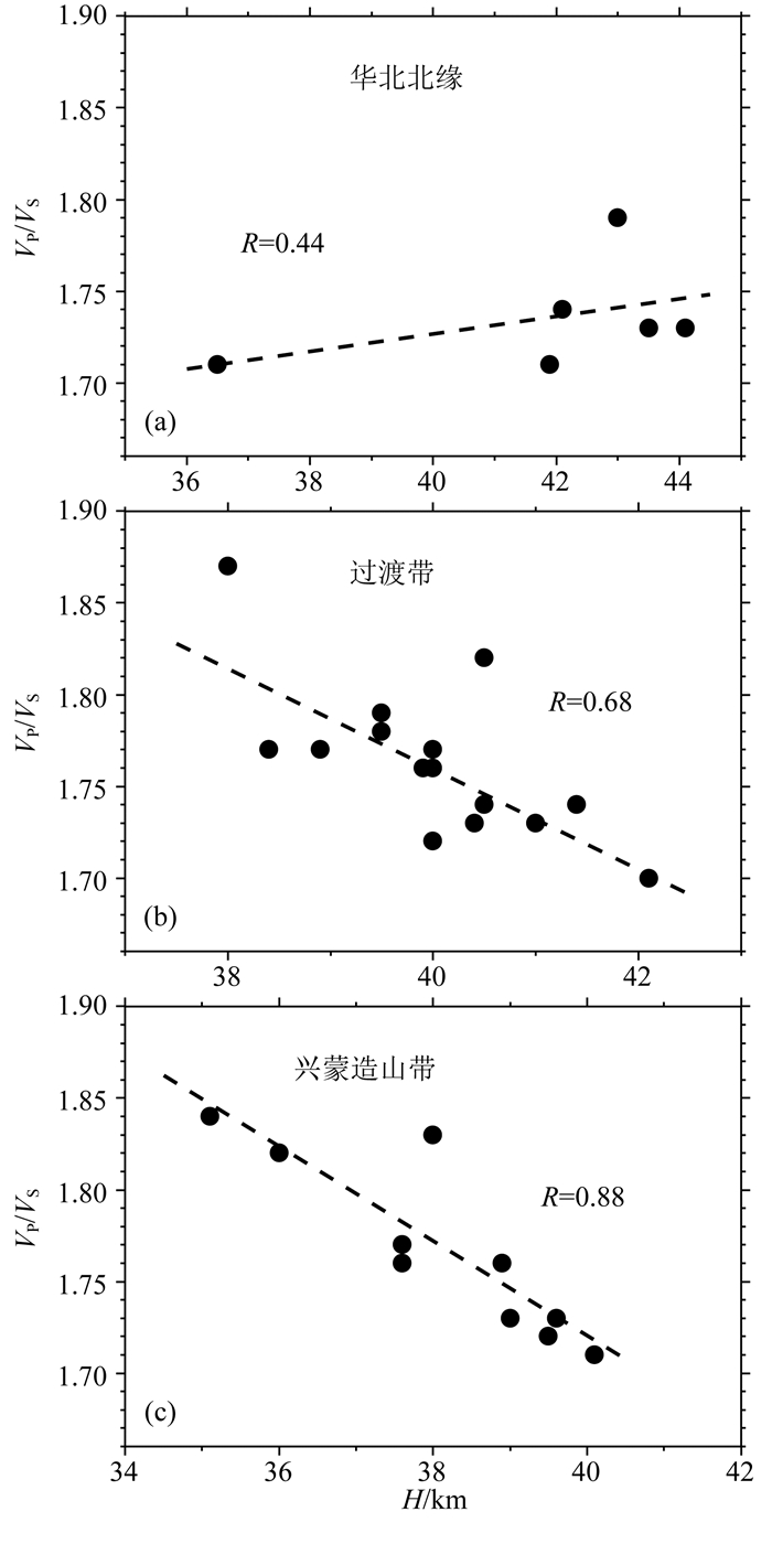
值得注意的是阿巴嘎火山群地区是第四纪火山活动区,地壳厚度较薄且波速比相对较高,同时波速比与地壳厚度呈反相关关系(图 7c).前人根据地壳厚度和波速比的相关关系,提出了几种流变形构造模式,用以约束大陆地壳的构造演化过程(嵇少丞等, 2009).解释地壳厚度和波速比值的反相关关系主要有两种模式:一为构造挤压下的地壳增厚与下地壳拆沉模式,另一种为拉张环境下基性岩浆的底侵模式(嵇少丞等, 2009).阿巴嘎火山群地区可能是拉张环境下基性岩浆的底侵模式.在构造伸展作用下,阿巴嘎火山群地区的地壳遭受了新生代第四纪多期火山作用的强烈改造(白志达等, 2012; 杨若昕等, 2012),不仅导致了地壳减薄,而且使得大量的铁镁质物质侵入到下地壳(白志达等, 2012),从而引起了阿巴嘎火山群地区波速比值的显著增高.剖面a的NM35位于阿巴嘎火山群,台站下方30 km深度附近存在显著的负振幅异常(图 6a),可能是从低速到高速的转换波的反映,暗示着火山作用后尚未完全冷却结晶的残余铁镁质火山岩物质的存在.
|
图 7 地壳厚度和波速比值关系图R为相关系数. Fig. 7 Relationship of crustal thickness and Vp/Vs values R is the correlation coefficient. |
在阿巴嘎火山地区,Liu等(2017)利用噪声联合成像方法揭示在15~70 km范围内存在3.1%~8.7%的横波速度异常,认为从下地壳到上地幔可能存在1%的部分熔融,这可能是锡林浩特—阿巴嘎火山岩浆的来源通道(Liu et al., 2017).体波成像研究结果(Zhang et al., 2017)显示阿巴嘎火山以及蒙古高原的达里甘嘎火山有深达过渡带间断面的低速结构,推测板内火山可能与板块俯冲所导致的上地幔热物质上涌有关(Davies and Bunge, 2006; Faccenna et al., 2010).在上地幔较浅地区存在低速层,认为是热物质上涌到岩石圈底部形成一个大的热源,在岩石圈较薄或者处于拉张状态的地区出现了上地幔部分熔融进而诱发了地表岩浆活动(Zhang et al., 2017).
4 结论本文通过在兴蒙造山带阿巴嘎地区布设的36个流动观测台站,结合中国数字地震台网的2个固定台站接收到的地震波形数据,采用远震P波接收函数方法,获得了台站下方的地壳厚度和平均波速比值,采用CCP叠加方法,揭示了研究区的Moho面起伏形态.该地区地壳厚度介于35~44 km之间,平均值约为40 km.研究区地壳整体上由西南向东北逐渐减薄,最薄的地壳位于阿巴嘎火山群.CCP获得的Moho面相对较平缓,可能与该地区后期经历的区域拉伸作用有关,但整体上Moho面的界面特征与三条缝合带有一定的相关性.地壳的平均波速比值位于1.70~1.87之间,平均值为1.76.阿巴嘎火山群地区存在大量的第四纪玄武岩,从而导致了该地区较高的地壳波速比值.阿巴嘎火山群地区地壳的减薄和波速比值的增高可能是拉张环境下新生代火山活动的底侵作用所导致.
致谢 感谢余大新博士、杨歧焱博士、强正阳博士、高占永硕士、谢振新博士等野外台站布设人员的辛勤劳动!感谢吴振波博士在数据处理过程中给予的帮助以及两位审稿老师提出的宝贵指导意见!
Badarch G, Cunningham W D, Windley B F. 2002. A new terrane subdivision for Mongolia:implications for the Phanerozoic crustal growth of Central Asia. Journal of Asian Earth Sciences, 21(1): 87-110. DOI:10.1016/S1367-9120(02)00017-2 |
Bai D H, Zhang L, Kong X R, et al. 1993. A magnetotelluric study of the paleozoic collision zone in the east of Inner-Mongolia:I. Observations and data analyses. Acta Geophysica Sinica (in Chinese), 36(3): 326-336. |
Bai Z D, Tan Q W, Xu G L, et al. 2012. Late Quaternary volcanic activity and neotectonics in the eastern Inner Mongolia. Acta Petrologica Sinica (in Chinese), 28(4): 1099-1107. |
Barry T L, Kent R W. 1998. Cenozoic magmatism in Mongolia and the origin of central and east Asian basalts. //Flower M F J, et al., Eds. Mantle Dynamics and Plate Interactions in East Asia. AGU Geodynamics Series, vol. 27, pp. 347-364. http://onlinelibrary.wiley.com/doi/10.1029/GD027p0347/summary
|
Barry T L, Saunders A D, Kemptom P D, et al. 2003. Petrogenesis of Cenozoic Basalts from Mongolia:Evidence for the Role of Asthenospheric versus Metasomatized Lithospheric Mantle Sources. Journal of Petrology, 44(1): 55-91. DOI:10.1093/petrology/44.1.55 |
Bird P. 1978. Initiation of intracontinental subduction in the Himalaya. Journal of Geophysical Research Solid Earth, 83(B10): 4975-4987. DOI:10.1029/JB083iB10p04975 |
Bird P. 1979. Continental delamination and the Colorado Pateau. Journal of Geophysical Research Solid Earth, 84(B13): 7561-7571. DOI:10.1029/JB084iB13p07561 |
Chen B, Jahn B M, Tian W. 2009. Evolution of the Solonker suture zone:Constraints from zircon U-Pb ages, Hf isotopic ratios and whole-rock Nd-Sr isotope compositions of subduction-and collision-related magmas and forearc sediments. Journal of Asian Earth Sciences, 34(3): 245-257. DOI:10.1016/j.jseaes.2008.05.007 |
Christensen N I, Mooney W D. 1995. Seismic velocity structure and composition of the continental crust:A global view. Journal of Geophysical Research, 100(B6): 9761-9788. DOI:10.1029/95JB00259 |
Christensen N I. 1996. Poisson's ratio and crustal seismology. Journal of Geophysical Research, 101(B2): 3139-3156. DOI:10.1029/95JB03446 |
Davies J H, Bunge H P. 2006. Are splash plumes the origin of minor hotspots?. Geology, 34(5): 349-352. DOI:10.1130/G22193.1 |
Dueker K G, Sheehan A F. 1997. Mantle discontinuity structure from midpoint stacks of converted P to S waves across the Yellowstone hotspot track. Journal of Geophysical Research, 102(B4): 8313-8327. DOI:10.1029/96JB03857 |
Faccenna C, Becker T W, Lallemand S, et al. 2010. Subduction-triggered magmatic pulses:A new class of plumes?. Earth and Planetary Science Letters, 299(1): 54-68. DOI:10.1016/j.epsl.2010.08.012 |
Gao Y G, Li Y H. 2014. Crustal thickness and Vp/Vs in the Northeast China-North China region and its geological implication. Chinese Journal of Geophysics (in Chinese), 57(3): 847-857. DOI:10.6038/cjg20140314 |
Gong C, Li Q S, Ye Z, et al. 2016. Crustal thickness and Poisson ratio beneath the Huailai-Bayinonder profile derived from teleseismic receiver functions. Chinese Journal of Geophysics (in Chinese), 59(3): 897-911. DOI:10.6038/cjg20160312 |
Guo P Y, Niu Y L, Sun P, et al. 2016a. The origin of Cenozoic basalts from central Inner Mongolia, East China:The consequence of recent mantle metasomatism genetically associated with seismically observed paleo-Pacific slab in the mantle transition zone. Lithos, 240-243: 104-118. DOI:10.1016/j.lithos.2015.11.010 |
Guo Z, Yang Y J, Chen Y J. 2016b. Crustal radial anisotropy in Northeast China and its implications for the regional tectonic extension. Geophysical Journal International, 207(1): 197-208. DOI:10.1093/gji/ggw261 |
Guo Z, Chen Y J, Ning J Y, et al. 2016c. Seismic evidence of on-going sublithosphere upper mantle convection for intra-plate volcanism in Northeast China. Earth and Planetary Science Letters, 433: 31-43. DOI:10.1016/j.epsl.2015.09.035 |
Guo Z, Chen Y J, Ning J Y, et al. 2015. High resolution 3-D crustal structure beneath NE China from joint inversion of ambient noise and receiver functions using NECESSArray data. Earth and Planetary Science Letters, 416: 1-11. DOI:10.1016/j.epsl.2015.01.044 |
He J, Wu Q J, Gao M T, et al. 2014. Crustal structure and Poisson ratio beneath the central and southern Mongolia derived from receiver functions. Chinese Journal of Geophysics (in Chinese), 57(7): 2386-2394. DOI:10.6038/cjg20140732 |
He J, Sandvol E, Wu Q J, et al. 2017. Attenuation of regional seismic phases (Lg and Sn) in Eastern Mongolia. Geophysical Journal International, 211(2): 979-989. DOI:10.1093/gji/ggx349 |
He J, Wu Q J, Sandvol E, et al. 2016. The crustal structure of south central Mongolia using receiver functions. Tectonics, 35(6): 1392-1403. DOI:10.1002/2015TC004027 |
Ho K S, Liu Y, Chen J C, et al. 2008. Elemental and Sr-Nd-Pb isotopic compositions of late Cenozoic Abaga basalts, Inner Mongolia:Implications for petrogenesis and mantle process. Geochemical Journal, 42(4): 339-357. DOI:10.2343/geochemj.42.339 |
Huang J X, Zhao Z D, Zhang H F, et al. 2006. Elemental and Sr-Nd-Pb isotopic geochemistry of the Wenduermiao and Bayanaobao-Jiaoqier ophiolites, Inner Mongolia:Constraints for the characteristics of the mantle domain of eastern Paleo-Asian Ocean. Acta Petrologica Sinica (in Chinese), 22(12): 2889-2900. |
Jahn B M. 2004. The central Asian orogenic belt and growth of the continental crust in the phanerozoic. //Malpas J, Fletcher C J N, Ali J R, et al, eds. Aspects of the Tectonic Evolution of China. London: Geological Society of London, 73-100. https://www.mendeley.com/research-papers/central-asian-orogenic-belt-growth-continental-crust-phanerozoic/
|
Jahn B M, Wu F Y, Chen B. 2000. Massive granitoid generation in Central Asia:Nd isotope evidence and implication for continental growth in the Phanerozoic. Episodes, 23(2): 82-92. |
Ji S C, Wang Q, Yang W C. 2009. Correlation between crustal thickness and poisson's ratio in the North China craton and its implication for lithospheric thinning. Acta Geologica Sinica (in Chinese), 83(3): 324-330. |
Jian P, Liu D Y, Kröner A, et al. 2008. Time scale of an early to mid-Paleozoic orogenic cycle of the long-lived Central Asian Orogenic Belt, Inner Mongolia of China:Implications for continental growth. Lithos, 101(3-4): 233-259. DOI:10.1016/j.lithos.2007.07.005 |
Kröner A, Windley B F, Badarch G, et al. 2007. Accretionary growth and crust formation in the Central Asian Orogenic Belt and comparison with the Arabian-Nubian shield. //Hatcher R D Jr, Carlson M P, McBride J H, et al, eds. 4-D Framework of Continental Crust. Boulder, CO: Geological Society of America Memoir, 200: 181-209. https://www.mendeley.com/research-papers/accretionary-growth-crust-formation-central-asian-orogenic-belt-comparison-arabiannubian-shield/
|
Langston C A. 1979. Structure under Mount Rainier, Washington, inferred from teleseismic body waves. Journal of Geophysical Research, 84(B9): 4749-4762. DOI:10.1029/JB084iB09p04749 |
Li W H, Keller G R, Gao R, et al. 2013a. Crustal structure of the northern margin of the North China Craton and adjacent region from SinoProbe02 North China seismic WAR/R experiment. Tectonophysics, 606: 116-126. DOI:10.1016/j.tecto.2013.04.007 |
Li W H, Gao R, Randy K, et al. 2014. Crustal structure of the northern margin of north China craton from Huailai to Sonid Youqi profile. Chinese Journal of Geophysics (in Chinese), 57(2): 472-483. DOI:10.6038/cjg20140213 |
Li Y H, Wu Q J, Pan J T, et al. 2012. S-wave velocity structure of northeastern China from joint inversion of Rayleigh wave phase and group velocities. Geophysical Journal International, 190(1): 105-115. DOI:10.1111/gji.2012.190.issue-1 |
Li Y H, Wu Q J, Pan J T, et al. 2013b. An upper-mantle S-wave velocity model for East Asia from Rayleigh wave tomography. Earth and Planetary Science Letters, 377-378: 367-377. DOI:10.1016/j.epsl.2013.06.033 |
Li Y K, Gao R, Yao Y T, et al. 2014. Crustal velocity structure from the northern margin of the North China Craton to the southern margin of the Siberian plate. Chinese Journal of Geophysics (in Chinese), 57(2): 484-497. DOI:10.6038/cjg20140214 |
Ligorría J P, Ammon C J. 1999. Iterative deconvolution and receiver-function estimation. Bulletin of the Seismological Society of America, 89(5): 1395-1400. |
Liu Y N, Niu F L, Chen M, et al. 2017. 3-D crustal and uppermost mantle structure beneath NE China revealed by ambient noise adjoint tomography. Earth and Planetary Science Letters, 461: 20-29. DOI:10.1016/j.epsl.2016.12.029 |
Liu Z K, Huang J L, Yao H J. 2016. Anisotropic Rayleigh wave tomography of Northeast China using ambient seismic noise. Physics of the Earth and Planetary Interiors, 256: 37-48. DOI:10.1016/j.pepi.2016.05.001 |
Lowry A R, Pérez-Gussinyé M. 2011. The role of crustal quartz in controlling Cordilleran deformation. Nature, 471(7338): 353-357. DOI:10.1038/nature09912 |
Meng Q R. 2003. What drove late Mesozoic extension of the northern China-Mongolia tract?. Tectonophysics, 369(3-4): 155-174. DOI:10.1016/S0040-1951(03)00195-1 |
Phinney R A. 1964. Structure of the Earth's crust from spectral behavior of long-period body waves. Journal of Geophysical Research, 69(14): 2997-3017. DOI:10.1029/JZ069i014p02997 |
Pan J T, Li Y H, Wu Q J, et al. 2014a. 3-D S-wave velocity structure of crust and upper-mantle beneath the northeast China. Chinese Journal of Geophysics (in Chinese), 57(7): 2077-2087. DOI:10.6038/cjg20140705 |
Pan J T, Wu Q J, Li Y H, et al. 2014b. Ambient noise tomography in northeast China. Chinese Journal of Geophysics (in Chinese), 57(3): 812-821. DOI:10.6038/cjg20140311 |
Qiang Z Y, Wu Q J, Li Y H, et al. 2017. Complicated seismic anisotropy beneath south-central Mongolia and its geodynamic implications. Earth and Planetary Science Letters, 465: 126-133. DOI:10.1016/j.epsl.2017.02.035 |
Sengör A M C, Natal'in B A, Burtman V S. 1993. Evolution of the Altaid tectonic collage and Palaeozoic crustal growth in Eurasia. Nature, 364(6435): 299-307. DOI:10.1038/364299a0 |
Shao J A, Zang S X, Mou B L, et al. 1995. Extension of orogenic belts and upwelling of asthenosphere:the example of Hinggan-Mongolian orogenic belt. Chinese Science Bulletin, 40(1): 50-56. |
Shi Y R, Liu D Y, Zhang Q, et al. 2007. SHRIMP U-Pb zircon dating of Triassic A-type granites in Sonid Zuoqi, central Inner Mongolia, China, and its tectonic implications. Geological Bulletin of China (in Chinese), 26(2): 183-189. |
Smith A D. 2013. The Geodynamic Significance of the DUPAL Anomaly in Asia. //Flower M F J, Chung S L, Lo C H, et al, eds. Mantle Dynamics and Plate Interactions in East Asia. Washington, DC: American Geophysical Union, 89-105. http://www.agu.org/books/gd/v027/GD027p0089/GD027p0089.shtml
|
Tao K, Niu F L, Ning J Y, et al. 2014. Crustal structure beneath NE China imaged by NECESSArray receiver function data. Earth and Planetary Science Letters, 398: 48-57. DOI:10.1016/j.epsl.2014.04.043 |
Tong Y, Hong D W, Wang T, et al. 2010. Spatial and temporal distribution of granitoids in the middle segment of the sino-mongolian border and its tectonic and metallogenic implications. Acta Geoscientica Sinica (in Chinese), 31(3): 395-412. |
Tarkov A P, Vavakin V V. 1982. Poisson's ratio behaviour in various crystalline rocks:application to the study of the Earth's interior. Physics of the Earth and Planetary Interiors, 29(1): 24-29. DOI:10.1016/0031-9201(82)90134-0 |
Wang Q, Huang Q H. 2016. The spatio-temporal characteristics of geomagnetic induction vectors in North China. Chinese Journal of Geophysics (in Chinese), 59(1): 215-228. DOI:10.6038/cjg20160118 |
Wang X C, Ding Z F, Zhu L P. 2016. Lithospheric structure of the northeastern North China craton imaged by s receiver functions. Pure and Applied Geophysics, 173(8): 2727-2736. DOI:10.1007/s00024-016-1293-0 |
Wang X C, Wilde S A, Li Q L, et al. 2015. Continental flood basalts derived from the hydrous mantle transition zone. Nature Communications, 6: 7700. DOI:10.1038/ncomms8700 |
Windley B F, Allen M B. 1993. Mongolian plateau:Evidence for a late cenozoic mantle plume under Central Asia. Geology, 21(4): 295-298. DOI:10.1130/0091-7613(1993)021<0295:MPEFAL>2.3.CO;2 |
Windley B F, Alexeiev D, Xiao W, et al. 2007. Tectonic models for accretion of the Central Asian Orogenic Belt. Journal of the Geological Society, 164(1): 31-47. DOI:10.1144/0016-76492006-022 |
Wu C, Liu C F, Zhu Y, et al. 2016. Early Paleozoic magmatic history of central Inner Mongolia, China:implications for the tectonic evolution of the Southeast Central Asian Orogenic Belt. International Journal of Earth Sciences, 105(5): 1307-1327. DOI:10.1007/s00531-015-1250-7 |
Wu F Y, Jahn B M, Wilde S A, et al. 2003a. Highly fractionated Ⅰ-type granites in NE China (Ⅱ):isotopic geochemistry and implications for crustal growth in the Phanerozoic. Lithos, 67(3): 191-204. |
Wu F Y, Jahn B M, Wilde S A, et al. 2003b. Highly fractionated Ⅰ-type granites in NE China (Ⅰ):geochronology and petrogenesis. Lithos, 66(3-4): 241-273. DOI:10.1016/S0024-4937(02)00222-0 |
Wu F Y, Sun D Y, Ge W C, et al. 2011. Geochronology of the Phanerozoic granitoids in northeastern China. Journal of Asian Earth Sciences, 41(1): 1-30. DOI:10.1016/j.jseaes.2010.11.014 |
Wu Y, Ding Z F, Zhu L P. 2011. Crustal structure of the North China Craton from teleseismic receiver function by the Common Conversion Point stacking method. Chinese Journal of Geophysics (in Chinese), 54(10): 2528-2537. DOI:10.3969/j.issn.0001-5733.2011.10.010 |
Xiao W J, Windley B F, Hao J, et al. 2003. Accretion leading to collision and the Permian Solonker suture, Inner Mongolia, China:Termination of the central Asian orogenic belt. Tectonics, 22(6): 1069. |
Xiao W J, Windley B F, Badarch G, et al. 2004. Palaeozoic accretionary and convergent tectonics of the southern Altaids:implications for the growth of Central Asia. Journal of the Geological Society, 161(3): 339-342. DOI:10.1144/0016-764903-165 |
Xu B, Charvet J, Chen Y, et al. 2013. Middle Paleozoic convergent orogenic belts in western Inner Mongolia (China):framework, kinematics, geochronology and implications for tectonic evolution of the Central Asian Orogenic Belt. Gondwana Research, 23(4): 1342-1364. DOI:10.1016/j.gr.2012.05.015 |
Yang R X, Bai Z D, Tan Q W, et al. 2012. Study on the geology of Gezi Shan volcano in Xilinhot, Inner Mongolia. Acta Petrologica Sinica (in Chinese), 28(4): 1181-1188. |
Yu D X, Wu Q J, Li Y H, et al. 2015. Rayleigh wave tomography of the phase velocity in the central and southern Mongolia. Chinese Journal of Geophysics (in Chinese), 58(1): 134-142. DOI:10.6038/cjg20150111 |
Yu D X, Wu Q J, Wang P, et al. 2016. Love wave phase velocity tomography in the south-central Mongolia from earthquakes. Acta Seismologica Sinica (in Chinese), 38(1): 41-52. |
Zandt G, Ammon C J. 1995. Continental crust composition constrained by measurements of crustal poisson's ratio. Nature, 374(6518): 152-154. DOI:10.1038/374152a0 |
Zhang F X, Wu Q J, Li Y H. 2013. The traveltime tomography study by teleseismic P wave data in the Northeast China area. Chinese Journal of Geophysics (in Chinese), 56(8): 2690-2700. DOI:10.6038/cjg20130818 |
Zhang F X, Wu Q J, Grand S P, et al. 2017. Seismic velocity variations beneath central Mongolia:Evidence for upper mantle plumes?. Earth and Planetary Science Letters, 459: 406-416. DOI:10.1016/j.epsl.2016.11.053 |
Zhang R Q, Wu Q J, Sun L, et al. 2014a. Crustal and lithospheric structure of Northeast China from S-wave receiver functions. Earth and Planetary Science Letters, 401: 196-205. DOI:10.1016/j.epsl.2014.06.017 |
Zhang S H, Gao R, Li H Y, et al. 2014b. Crustal structures revealed from a deep seismic reflection profile across the Solonker suture zone of the Central Asian Orogenic Belt, northern China:An integrated interpretation. Tectonophysics, 612-613: 26-39. DOI:10.1016/j.tecto.2013.11.035 |
Zhang G C, Wu Q J, Pan J T, et al. 2013. Study of crustal structure and Poisson ratio of NE China by H-κ stack and CCP stack methods. Chinese Journal of Geophysics (in Chinese), 56(12): 4084-4094. DOI:10.6038/cjg20131213 |
Zhu L P. 2000. Crustal structure across the San Andreas Fault, southern California from teleseismic converted waves. Earth and Planetary Science Letters, 179(1): 183-190. DOI:10.1016/S0012-821X(00)00101-1 |
Zhu L P, Kanamori H. 2000. Moho depth variation in southern California from teleseismic receiver functions. Journal of Geophysical Research, 105(B2): 2969-2980. DOI:10.1029/1999JB900322 |
白登海, 张丽, 孔祥儒, 等. 1993. 内蒙古东部古生代块体碰撞区的大地电磁测深研究——Ⅰ.观测与资料分析. 地球物理学报, 36(3): 326-336. DOI:10.3321/j.issn:0001-5733.1993.03.007 |
白志达, 谭庆伟, 许桂玲, 等. 2012. 内蒙东部晚第四纪火山活动与新构造. 岩石学报, 28(4): 1099-1107. |
龚辰, 李秋生, 叶卓, 等. 2016. 远震P波接收函数揭示的张家口(怀来)-中蒙边境(巴音温多尔)剖面地壳厚度与泊松比. 地球物理学报, 59(3): 897-911. DOI:10.6038/cjg20160312 |
何静, 吴庆举, 高孟潭, 等. 2014. 利用接收函数方法研究蒙古中南部地区地壳结构. 地球物理学报, 57(7): 2386-2394. DOI:10.6038/cjg20140732 |
高延光, 李永华. 2014. 中国东北-华北地区地壳厚度与泊松比及其地质意义. 地球物理学报, 57(3): 847-857. DOI:10.6038/cjg20140314 |
黄金香, 赵志丹, 张宏飞, 等. 2006. 内蒙古温都尔庙和巴彦敖包-交其尔蛇绿岩的元素与同位素地球化学:对古亚洲洋东部地幔域特征的限制. 岩石学报, 22(12): 2889-2900. |
嵇少丞, 王茜, 杨文采. 2009. 华北克拉通泊松比与地壳厚度的关系及其大地构造意义. 地质学报, 83(3): 324-330. |
李文辉, 高锐, RandyK, 等. 2014. 华北克拉通北缘(怀来-苏尼特右旗)地壳结构. 地球物理学报, 57(2): 472-483. DOI:10.6038/cjg20140213 |
李英康, 高锐, 姚聿涛, 等. 2014. 华北克拉通北缘-西伯利亚板块南缘的地壳速度结构特征. 地球物理学报, 57(2): 484-497. DOI:10.6038/cjg20140214 |
潘佳铁, 李永华, 吴庆举, 等. 2014a. 中国东北地区地壳上地幔三维S波速度结构. 地球物理学报, 57(7): 2077-2087. DOI:10.6038/cjg20140705 |
潘佳铁, 吴庆举, 李永华, 等. 2014b. 中国东北地区噪声层析成像. 地球物理学报, 57(3): 812-821. DOI:10.6038/cjg20140311 |
邵济安, 臧绍先, 牟保磊, 等. 1994. 造山带的伸展构造与软流圈隆起——以兴蒙造山带为例. 科学通报, 39(6): 533-537. |
石玉若, 刘敦一, 张旗, 等. 2007. 内蒙古中部苏尼特左旗地区三叠纪A型花岗岩锆石SHRIMP U-Pb年龄及其区域构造意义. 地质通报, 26(2): 183-189. DOI:10.3969/j.issn.1671-2552.2007.02.009 |
童英, 洪大卫, 王涛, 等. 2010. 中蒙边境中段花岗岩时空分布特征及构造和找矿意义. 地球学报, 31(3): 395-412. |
王桥, 黄清华. 2016. 华北地磁感应矢量时空特征分析. 地球物理学报, 59(1): 215-228. DOI:10.6038/cjg20160118 |
武岩, 丁志峰, 朱露培. 2011. 利用共转换点叠加方法研究华北地区地壳结构. 地球物理学报, 54(10): 2528-2537. DOI:10.3969/j.issn.0001-5733.2011.10.010 |
杨若昕, 白志达, 谭庆伟, 等. 2012. 内蒙锡林浩特鸽子山火山地质研究. 岩石学报, 28(4): 1181-1188. |
余大新, 吴庆举, 李永华, 等. 2015. 蒙古中南部地区面波相速度层析成像. 地球物理学报, 58(1): 134-142. DOI:10.6038/cjg20150111 |
余大新, 吴庆举, 王鹏, 等. 2016. 蒙古中南部地区基于天然地震的勒夫波相速度层析成像. 地震学报, 38(1): 41-52. |
张风雪, 吴庆举, 李永华. 2013. 中国东北地区远震P波走时层析成像研究. 地球物理学报, 56(8): 2690-2700. DOI:10.6038/cjg20130818 |
张广成, 吴庆举, 潘佳铁, 等. 2013. 利用H-K叠加方法和CCP叠加方法研究中国东北地区地壳结构与泊松比. 地球物理学报, 56(12): 4084-4094. DOI:10.6038/cjg20131213 |
 2018, Vol. 61


