2. 青岛海洋科学与技术国家实验室海洋地质过程与环境功能实验室, 青岛 266061;
3. 中国科学院大学, 北京 100049;
4. 中国石油大学(华东), 青岛 266580
2. Laboratory for Marine Geology, Qingdao National Laboratory for Marine Science and Technology, Qingdao 266061, China;
3. University of Chinese Academy of Sciences, Beijing 100049, China;
4. China University of Petroleum, Qingdao 266580, China
重力、磁力、地震等地球物理调查方法是研究一个海区地球物理场概况的基础(刘光鼎,2007;骆迪等,2014),基于地球物理调查成果的联合反演技术是定量了解研究区地壳结构的重要手段(陈洁等,2007;林珍等,2013),能够为海区内典型剖面的分析提供依据.重-磁-震联合反演得到的地壳结构能够清晰地揭示一个区域的构造特征,较为准确地给出重磁异常体的分布,对该区域的地球动力学特征与地壳演化具有重要的指示作用(滕吉文,2008;杨文采等,2016).
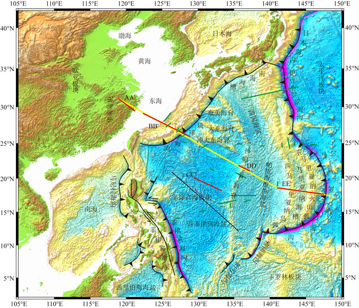
中国海—西太平洋地区位于亚欧板块、太平洋板块和印澳板块的交汇处,其主体由菲律宾海板块构成,海区内发育多个俯冲系统(图 1),如菲律宾海板块东部的伊豆—小笠原—马里亚纳俯冲系统,西部的琉球海沟、菲律宾海沟等.特殊的地理位置以及众多的俯冲系统使得中国海—西太平洋地区构造活动强烈,演化历史复杂(胡立天等,2016),具有重要的研究意义.因此,通过对横跨整个中国海—西太平洋地区的典型剖面(图 1)进行重-磁-震联合反演有助于加深我们对中国海—西太平洋地区深部构造特征的整体理解,进一步促进对大陆边缘演化与板块相互作用的认识.
|
图 1 中国海—西太平洋地区构造纲要图 黄色线段为本次研究的重-磁-震联合反演剖面位置,黑色线段为中科院海洋所2015年利用“科学号”考察船在西菲律宾海采集的1400 km地球物理大断面,绿色及红色线段为收集的地震速度剖面,其中红色线段为主要参考的地震速度剖面(Murauchi et al., 1968; Goodman et al., 1989; 孔祥儒等,1995;高德章等,2004;Nishizawa et al., 2007; Takahashi et al., 2007) Fig. 1 The tectonic outline in the China Sea-Western Pacific area The yellow line represents the location of the typical profile along which the gravity-magnetic-seismic joint inversion was conducted in this study. The black line represents the 1400 km profile and the geophysical data were collected by research Vessel Kexue, Institute of Oceanology, China Academy of Sciences in Philippine Sea in 2015, whereas the green and red lines represent the seismic velocity profiles collected from other studies, among of which, the red lines also represent the seismic velocity profiles for reference (Kong et al., 1995; Gao et al., 2004; Murauchi et al., 1968; Goodman et al., 1989; Nishizawa et al., 2007; Takahashi et al., 2007). |
前人对研究区内各个构造单元的地壳结构已进行了大量的研究,如浙江地区扬子块体地壳结构发育完整(Zhang et al., 2005),主要表现为简单的三层结构(范小林等,1992;王椿镛等,1999;李英康等,2002),具有稳定地台的速度结构特征(白志明等,2016),华夏块体发育贯穿地壳的深大断裂,同时伴有广泛的酸性岩浆岩体的侵入和中基性岩的喷发(于津海等,2007;邓阳凡等,2011);东海和冲绳海槽的地壳结构复杂,东海大陆架地区具有陆壳的性质,而冲绳海槽具有过渡壳的性质(如江为为等,2003;张训华和尚鲁宁,2014;余景峰等,2015);菲律宾海板块可能起源于中生代地体与“冲-大东地幔柱”之间的相互作用(Faccenna et al., 2010; Seton et al., 2015),其中西菲律宾海盆是菲律宾海板块内部最大的洋盆,形成时间约为54~33/30 Ma,海盆最后的扩张阶段为30~26 Ma(Hilde and Lee, 1984; Deschamps and Lallemand, 2002),具有比正常洋壳更薄的地壳厚度(Goodman, 1983; Arisaka et al., 2003);九州—帕劳海脊是菲律宾海板块内最长的无震脊(Lallemand, 2016),形成于太平洋板块的俯冲,裂离于四国—帕里西维拉海盆的弧后扩张(Ishizuka et al., 2011),是伊豆—小笠原—马里亚纳岛弧的残留弧(Karig, 1972;Okino et al., 1994),自南向北地壳结构存在明显的变化(Nishizawa et al., 2007, 2009;张洁等,2012);帕里西维拉海盆(32~18 Ma)(Mrozowski and Hayes, 1979)位于菲律宾海板块的东部,形成于西菲律宾海盆扩张停止之后(Chamot-Rooke et al., 1987; Okino et al., 1994, 1998),是典型的已经停止活动的弧后盆地;马里亚纳俯冲带由西马里亚纳岛弧、马里亚纳海槽和东马里亚纳火山弧组成,属于伊豆—小笠原—马里亚纳俯冲系统的一部分.俯冲最早开始于50~40 Ma,可能起源于中生代的地体(Nishizawa et al., 2014)与大洋板块之间的转换边界,不是典型的洋内俯冲(Shervais and Choi, 2012; Stern et al., 2012;Zahirovic et al., 2013).随着俯冲作用的进行,先后形成了西菲律宾海盆、四国—帕里西维拉海盆、马里亚纳海槽.已停止活动的西马里亚纳岛弧是由现今仍在活动的东马里亚纳火山弧裂离而来,中部的马里亚纳海槽是典型的弧后盆地,盆地扩张最早开始于7 Ma,且扩张仍在进行(Stern et al., 2003).
到目前为止,前人的研究大多集中于局部区域,尚缺乏以整体的视角和统一的方法来审视和研究中国海—西太平洋地区的地壳剖面结构.因此,本研究中,我们通过对横跨中国海—西太平洋地区典型剖面进行重-磁-震联合反演,获得了大陆-边缘海-大洋地壳结构的纵向特征,从而对中国海及西太平洋地区的地壳结构特征有一个整体的了解,有助于深入认识大陆边缘演化与板块的相互作用.
1 数据与方法 1.1 数据本研究所使用的数据主要包括水深数据、重磁异常数据、沉积物厚度、地壳速度结构剖面和实测地震剖面等,其中,水深、重磁和沉积物厚度等数据均为充分融合多家单位研究成果的权威数据.
水深数据采用美国国家地球物理数据中心(National Geophysical Data Center, NGDC)于2009年发布的ETOPO1数据.该数据主要由日本海洋数据中心发布的由船测水深数据网格化得到的0.5 km分辨率数据、NGDC于2006年发布的7弧秒船测水深网格化数据、里海环境规划署1999年发布的1弧分水深网格数据、地中海科学委员会2005年发布的0.5 km分辨率的网格数据综合得到(Amante and Eakins, 2009),网格分辨率为1弧分×1弧分.
重力异常数据来源于最新的、最具有影响力的卫星测高反演重力异常,由美国Scripps海洋研究所Sandwell小组于2014年发布.该重力异常数据覆盖全球海域及大型湖泊,是基于最新的具有高精度、高轨道密度、多轨道方向的两颗测高卫星(CryoSat-2和Jason-1)反演得到,数据的分辨率为1弧分×1弧分(Sandwell et al., 2014).
磁异常数据为geomag团队(http://www.geomag.us/)发布的覆盖全球的EMAG2网格数据,其原始数据包括SWARM和CHAMP卫星数据以及由百余家单位提供的其他各类数据,磁异常测算高度为4 km,分辨率为2弧分×2弧分.
沉积层厚度分布数据主要来源于NGDC发布的全球沉积层厚度数据集,涵盖全球各个海盆以及边缘海,主要由以下三种数据集融合而成:①被广泛采用的、由早期学者编制的沉积层厚度图集(如Ludwig et al., 1980; Divins and Rabinowitz, 1990; Hayes and Labrecque, 1991; Divins, 2003);②大洋钻探成果,包括大洋钻探计划(ODP)和深海钻探计划(DSDP)的钻探成果;③地震反射资料.数据分辨率为5弧分×5弧分.
浙江地区地壳速度结构主要参考1991年皖南屯溪—浙江温州的爆炸地震探测资料(孔祥儒等,1995);东海至冲绳海槽地区主要参考1998年上海海洋石油局与广州海洋地质调查局在东海南部地区采集的一条长度为725 km的重磁震综合探测剖面(高德章等,2004);菲律宾海盆区域的地球物理调查较少,地震剖面数据严重缺乏,因此重点参考2003年中、日、法合作的KR03-04综合调查航次数据以及前人文献中的地壳速度结构剖面,包括多道地震数据、海底地震仪数据等(Murauchi et al., 1968; Goodman et al., 1989; Nishizawa et al., 2007; Takahashi et al., 2007)(图 1).需要说明的是,西菲律宾海盆内的参考速度结构剖面CC′虽远离典型剖面,但考虑到洋盆内地壳结构的变化较小,具有较好的一致性及连续性,因此将其平移至典型剖面位置作为参考.中国科学院海洋所2015年利用“科学号”考察船在西菲律宾海采集了1400 km的地球物理大断面(采集参数见表 1),虽然断面位置与反演剖面位置不一致,也可以作为非常重要的参考约束反演结果.在进行重磁震联合反演时,各地层及地质体的密度主要参考前人(Asano et al., 1985; 高德章等,2004;Takahashi et al., 2007)的研究成果,如表 2所示.磁化率参数主要参考韩波(2008)的研究成果,如表 3和表 4所示.
|
|
表 1 多道地震采集参数 Table 1 Parameters of the multichannel seismic acquisition |
|
|
表 2 各岩性及地层层位密度值表 Table 2 The density of various lithology and layers |
|
|
表 3 东海地区钻井岩芯磁化率、剩磁、密度值统计表 Table 3 Magnetic susceptibility, remanent magnetization and density of the drilling cores in the East China Sea |
|
|
表 4 浙江地区岩石磁化率统计表 Table 4 Magnetic susceptibility of the rocks in Zhejiang area |
选用的每一类数据本身即是充分融合了多家单位研究成果的数据,能够覆盖研究区范围,其中,沉积物厚度数据在中国东海以及西菲律宾海的部分区域存在一定的空白,因此本研究使用全球三维地壳模型CRUST1.0(分辨率为1°×1°的数据)进行插值来填补该空白.重磁数据网格化过程均采用墨卡托投影,原点经度127.5°E,标准纬度27°N.
地壳厚度反演过程中,重力、地形、沉积物厚度作为输入数据,用CRUST1.0给定的莫霍面埋深作为重力反演的参考埋深.首先利用ArcGIS生成水深等值线,并以此为基础,生成一个代表地壳密度分布的网格文件(洋壳区域密度设为2.85 g·cm-3,陆壳、洋底高原和岛弧密度设为2.7 g·cm-3);然后,将各类数据整编到同一数据集,使用ArcGIS软件将所有输入的网格数据重新采样至2弧分×2弧分的网格分辨率,包括水深与地形、沉积层厚度、重磁异常、洋壳年龄、地壳密度等多类网格文件;最后,采用Matlab编程实现岩石圈中沉积层以及岩石圈地幔的密度建模功能.
1.3 方法步骤(1) 依据多道地震剖面资料,建立浅部沉积层地震波速度分布及界面起伏、参考深部折射/反射资料,根据浅层及深部速度结构,利用密度-速度关系、测井资料及岩石物性分析设计初始密度参数、界面起伏和磁化率模型;
(2) 没有可供参考的地震剖面资料时,首先反演出莫霍面埋深(图 2),再基于水深、沉积层厚度等数据,建立地壳、上地幔速度结构分布及主要速度界面起伏,设定相关的密度与磁化率;

|
图 2 重力场反演莫霍面埋深流程图(Bai et al., 2014) Fig. 2 The flow chart of Moho depth inversion based on the gravity field (Bai et al., 2014) |
(3) 利用Geosoft公司的Oasis montaj人机交互软件,计算模型的重磁异常,通过不断调整模型参数减小理论异常与观测异常的差异,最终建立岩石属性模型;
(4) 将反演结果与实测地震剖面、地质构造、钻井资料等进行对比,验证模型正确性;当反演模型与实际地质构造不符时,重复步骤(3),通过反复迭代使位场反演结果与实际地质构造解释相符;
(5) 最后结合重、磁、震和地质资料综合解释地震资料难以确定的深层界面,同时获取岩石圈的密度、磁化率等属性.
为了提高正常场计算的准确性,在拟合磁异常场时,采用分段拟合的方法,具体的分段方案及相关参数为:
① 浙江地区
经纬度范围:118.86° E, 29.727° N—122.47° E, 28.08° N
中点:120.665° E, 28.9035° N
地球参考场:47309.8964 nT, 43.07774384°, -4.6830267°
② 东海陆架盆地
经纬度范围:120.68° E, 28.919° N—125.99° E, 26.32° N
中点:123.335° E, 27.62° N
地球参考场:47315.7456 nT, 43.09997102°, -4.68895233°
③ 冲绳海槽—琉球海沟
经纬度范围:124.59° E, 27.036° N—130.07° E, 24.086° N
中点:127.33° E, 25.561° N
地球参考场:44051.3462 nT, 36.59563412°, -4.38911176°
④ 西菲律宾海盆:
经纬度范围:128.72° E, 24.843° N—134.97° E, 21.156° N
中点:131.85° E, 23.000° N
地球参考场:41763.3982 nT, 31.43044931°, -3.6008318°
⑤ 九州—帕劳海脊:
经纬度范围:133.36° E, 22.146° N—137.80° E, 19.349° N
中点:135.58° E, 20.748° N
地球参考场:39976.697 nT, 26.81387203°, -2.59196245°
⑥ 帕里西维拉海盆:
经纬度范围:136.36° E, 20.276° N—142.15° E, 17.077° N
中点:139.255° E, 18.6765° N
地球参考场:38393.5630 nT, 22.53418210°, -1.34445051°
⑦ 马里亚纳俯冲带:
经纬度范围:141.20° E, 17.201° N—148.64° E, 16.111° N
中点:144.92° E, 16.656° N
地球参考场:36849.0770 nT, 18.49388876°, 0.34282229°
2 重磁震联合反演剖面的地质构造解释典型剖面全长3450 km(附图),跨越了陆架(扬子块体、华夏块体、东海陆架盆地)、弧后盆地(冲绳海槽、马里亚纳海槽)、海沟(琉球海沟、马里亚纳海沟)、海底高原(冲大东海岭西南端海台)、海盆(西菲律宾海盆、帕里西维拉海盆)、残留岛弧(九州—帕劳海脊、西马里亚纳岛弧)、正在活动的火山岛弧(东马里亚纳火山弧)等不同成因类型的构造单元.典型剖面的重力异常拟合差为3.729 mGal,磁异常采取分段拟合.

|
附图 1 中国海—西太平洋地区典型剖面的重-磁-震联合反演结果及解释 (a)该剖面的磁力拟合曲线;(b)重力拟合曲线;(c)参考的速度结构剖面,数值代表波速, 单位为km·s-1; (d)反演得到的地壳结构和异常体分布情况,单数字代表密度,单位为g·cm-3, 异常体的磁化率格式为感应磁化强度/剩余磁化强度/磁倾角/磁偏角(如0.003/0/0/0),单位分别为cgs、A/m、(°). Appendix Fig. 1 The gravity-magnetic-seismic joint inversion and interpretation for the typical profile across the China Sea-Western Pacific area, in which the magnetic fitting curve (a), the gravity fitting curve (b), the velocity profile for reference (c) and the crustal structure and abnormal bodies distribution (d) are shown, respectively. The single numbers in (c) and (d) denote the velocity (km s1) and density (g·cm-3) respectively, whereas the numbers (e.g., 0.003/0/0/0) in (d) denote the induced magnetization, residual magnetization, inclination and declination of the abnormal bodies, whose units are cgs, A/m and degree, respectively |
研究区地壳厚度总体上呈现由陆壳向洋壳逐渐变薄的特点(图 3),洋壳中的特殊结构(如岛弧,残留脊、海台等)具有较大的地壳厚度.典型剖面经过的华南陆块,地壳厚度可达到30 km以上,明显区别于洋壳;东海陆架盆地和冲绳海槽的地壳厚度变化较大,地壳结构复杂;西菲律宾海盆地壳厚度较小,约为5~6 km;九州—帕劳海脊地壳厚度可达到10 km以上;四国—帕里西维拉海盆的地壳厚度可达到8 km,略大于西菲律宾海盆;马里亚纳俯冲带的东、西马里亚纳岛弧则具有更大的地壳厚度,可达15 km,而马里亚纳海槽处的地壳厚度只有7 km左右.

|
图 3 中国海—西太平洋地区地壳厚度图 Fig. 3 The crust thickness in China Sea-West Pacific area |
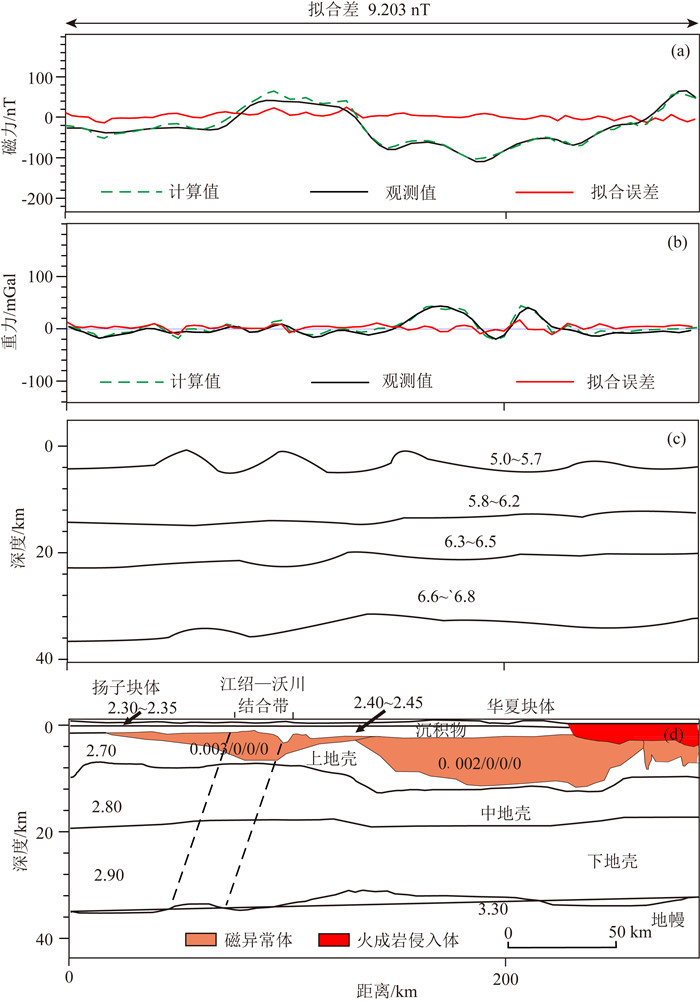
反演结果揭示了浙江地区发育有较大规模的磁异常体与火成岩侵入体(图 4).磁异常体主要沿断裂带分布,向扬子地块一侧逐渐减少,反映了断裂带处构造较为薄弱,岩浆容易在此处集中并沿断裂带上涌,而且岩浆岩的深度较浅,导致断裂带处出现明显的正磁力值;华夏块体分布有大范围的侵入岩,主要为浅部的火成岩体和深部磁化强度较高的磁异常体,对应浙东地区广泛分布地表的火成岩露头.浙江地区地壳基底深度在2 km左右,下部地壳三层结构明显(上地壳、中地壳、下地壳).莫霍面最深达到36 km,存在明显的山根,地壳西部较厚,向东逐渐变浅至30~28 km.华南大陆起源于新元古代不同块体的拼贴(Chu et al., 2012;张国伟等,2013),所以其复杂的结构和较大的地壳厚度是古老陆壳结构的体现.
|
图 4 浙江地区典型剖面的重-磁-震联合反演结果及解释 (a)该剖面的磁力拟合曲线;(b)重力拟合曲线;(c)参考的速度结构剖面,数值代表波速, 单位为km·s-1;(d)反演得到的地壳结构和异常体分布情况,单数字代表密度,单位为g·cm-3,异常体的磁化率格式为感应磁化强度/剩余磁化强度/磁倾角/磁偏角(如0.003/0/0/0),单位分别为cgs、A·m-1、(°). Fig. 4 The gravity-magnetic-seismic joint inversion and interpretation for the typical profile across Zhejiang area, in which the magnetic fitting curve 4a, the gravity fitting curve 4b, the velocity profile for reference 4c and the crustal structure and abnormal bodies distribution 4d are shown, respectively. The single numbers in 4c and 4d denote the velocity (km·s-1) and density respectively, whereas the numbers (e.g., 0.003/0/0/0) in 4d denote the induced magnetization, residual magnetization, inclination and declination of the abnormal bodies, whose units are cgs, A·m-1 and degree, respectively |
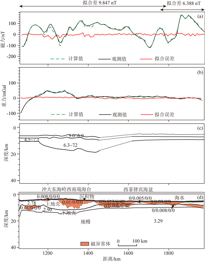
与浙江地区相比,东海地区的重磁异常变化较为剧烈.东海陆架盆地,重力异常变化较小,地层变化较平缓;冲绳海槽内存在重力异常极大值,说明有大量的火成岩侵入体,可能是由弧后扩张岩浆上涌所导致的(图 5a).东海地区存在大量的磁异常体,大部分磁异常体具有较高的感磁磁化率,也有具有剩磁异常的磁性体存在.重-磁-震联合反演结果显示(图 5d),东海陆架盆地莫霍面起伏较大,地壳与华南陆壳呈现出相似的结构,深度由西部的33 km向东逐渐减薄至26 km.冲绳海槽地区地壳厚度明显减薄,海槽中心地壳厚度约为18 km,较薄的地壳结构体现了冲绳海槽具有弧后拉张盆地的性质,其厚度大于典型洋壳.琉球岛弧及弧前坳陷区表层沉积物较厚,岛弧地壳呈现三层结构,发育较为完全.整体来看,东海地区地壳厚度变化较大,呈现过渡壳的性质.

|
图 5 东海地区典型剖面的重-磁-震联合反演结果及解释 (a)该剖面的磁力拟合曲线;(b)重力拟合曲线;(c)参考的速度结构剖面,数值代表波速, 单位为km·s-1;(d)反演得到的地壳结构和异常体分布情况,单数字代表密度,单位为g·cm-3,异常体的磁化率格式为感应磁化强度/剩余磁化强度/磁倾角/磁偏角(如0.003/0/0/0),单位分别为cgs、A·m-1、(°). Fig. 5 The gravity-magnetic-seismic joint inversion and interpretation for the typical profile across the East China Sea, in which the magnetic fitting curve 5a, the gravity fitting curve 5b, the velocity profile for reference 5c and the crustal structure and abnormal bodies distribution 5d are shown, respectively. The single numbers in 5c and 5d denote the velocity (km·s-1) and density respectively, whereas the numbers (e.g., 0.003/0/0/0) in 5d denote the induced magnetization, residual magnetization, inclination and declination of the abnormal bodies, whose units are cgs, A·m-1 and degree, respectively |
西菲律宾海盆大部分地区的重力异常接近0值(图 6a),无明显变化,海盆地壳已达到或接近均衡状态.海盆内的磁异常变化非常剧烈(图 6b),说明有大量的磁异常体存在.重-磁-震联合反演结果显示(图 6d),与浙江地区的陆壳结构、东海地区的过渡壳结构相比,剖面经过的西菲律宾海盆大部分为正常的洋壳,具有更薄的厚度,地壳结构可分为上地壳和下地壳,缺失中地壳.莫霍面起伏变化较小,各层厚度较为稳定,磁异常体广泛地分布,具有较大的剩磁磁化率,厚度不超过6 km,是西菲律宾海盆扩张过程的产物.冲大东海脊西南端海台,具有较厚的二层地壳结构,莫霍面起伏变化较大,地壳厚度大于正常洋壳.
|
图 6 西菲律宾海盆典型剖面的重-磁-震联合反演结果及解释 (a)该剖面的磁力拟合曲线;(b)重力拟合曲线;(c)参考的速度结构剖面,数值代表波速, 单位为km·s-1;(d)反演得到的地壳结构和异常体分布情况,单数字代表密度,单位为g·cm-3,异常体的磁化率格式为感应磁化强度/剩余磁化强度/磁倾角/磁偏角(如0.003/0/0/0),单位分别为cgs、A·m-1、(°). Fig. 6 The gravity-magnetic-seismic joint inversion and interpretation for the typical profile across the West Philippine Basin, in which the magnetic fitting curve 6a, the gravity fitting curve 6b, the velocity profile for reference 6c and the crustal structure and abnormal bodies distribution 6d are shown, respectively. The single numbers in 6c and 6d denote the velocity (km·s-1) and density respectively, whereas the numbers (e.g., 0.003/0/0/0) in 6d denote the induced magnetization, residual magnetization, inclination and declination of the abnormal bodies, whose units are cgs, A·m-1 and degree, respectively |
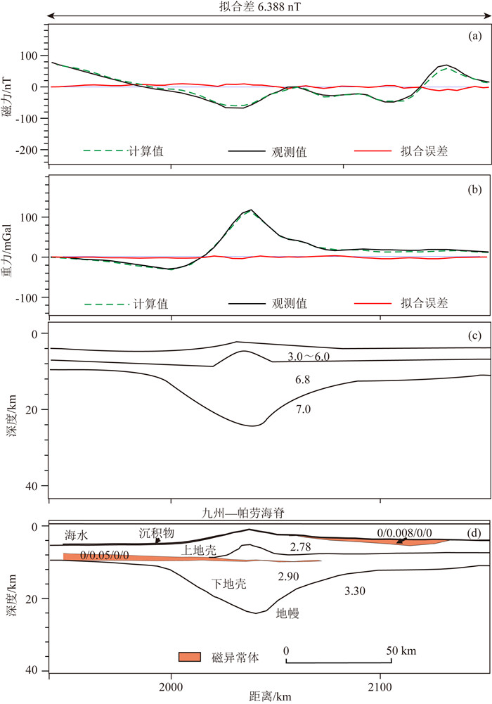
九州—帕劳海脊的自由空间重力异常为正值,与地形起伏相对应.磁异常变化较小,且基本为负值,说明有小规模的磁异常体存在.重-磁-震联合反演结果显示(图 7),九州—帕劳海脊的莫霍面深度较大,具有明显的山根与较厚的下地壳.上地壳厚度为1~5 km,下地壳厚度从5 km到15 km不等,呈现明显的岛弧地壳结构.海脊两侧分布有小规模的磁异常体,具有较大的剩磁磁化率,可能分别与西侧西菲律宾海盆和东侧帕里西维拉海盆的扩张有关.
|
图 7 九州—帕劳海脊典型剖面的重-磁-震联合反演结果及解释 (a)该剖面的磁力拟合曲线;(b)重力拟合曲线;(c)参考的速度结构剖面,数值代表波速, 单位为km·s-1;(d)反演得到的地壳结构和异常体分布情况,单数字代表密度,单位为g·cm-3,异常体的磁化率格式为感应磁化强度/剩余磁化强度/磁倾角/磁偏角(如0.003/0/0/0),单位分别为cgs、A·m-1、(°). Fig. 7 The gravity-magnetic-seismic joint inversion and interpretation for the typical profile across Kyushu-Palau ridge, in which the magnetic fitting curve 7a, the gravity fitting curve 7b, the velocity profile for reference 7c and the crustal structure and abnormal bodies distribution 7d are shown, respectively. The single numbers in 7c and 7d denote the velocity (km·s-1) and density respectively, whereas the numbers (e.g., 0.003/0/0/0) in 7d denote the induced magnetization, residual magnetization, inclination and declination of the abnormal bodies, whose units are cgs, A·m-1 and degree, respectively |
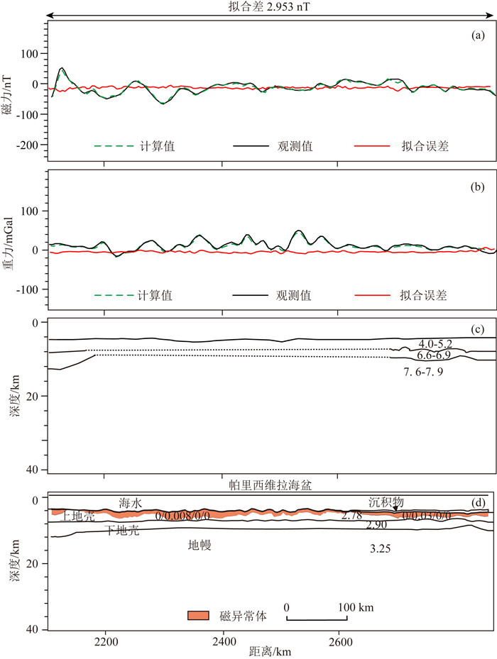
帕里西维拉海盆的自由空间重力异常基本为正值,大于相邻的西菲律宾海盆,说明帕里西维拉海盆可能尚未达到均衡状态.而且,自由空间异常的极大值和极小值并未与地形严格对应,而是较地形的极值点发生了东向偏移,可能暗示帕里西维拉海盆扩张的不对称性.帕里西维拉海盆与西菲律宾海盆的磁异常存在明显的差异,最大值出现在帕里西维拉海盆与九州—帕劳海脊相接的部位,约为60 nT;最小值出现在盆地的内部,约为-50 nT.
重磁震联合反演结果显示(图 8),尽管地形上海盆东西部表现为不同的特征,但地壳结构具有较好的一致性,结构较为简单,均由上地壳和下地壳构成,体现典型洋壳的性质,莫霍面深度横向变化不明显.需要注意的是,帕里西维拉海盆虽然形成时代晚于西菲律宾海盆,但地壳厚度(~8 km)略大于西菲律宾海盆,可能是海盆张裂于厚度较大的九州—帕劳海脊之上的结果,或者与海盆的扩张速率有关.帕里西维拉裂谷的地壳结构并未表现出不同于海盆其它部分的特征,海盆的扩张中心可能没有完全破裂.海盆内分布大范围的磁异常体,以帕里西维拉海盆的扩张轴为中心,向两侧延伸,厚度有变大的趋势,均存在剩磁磁化率,磁异常的均匀分布体现了弧后盆地稳定的扩张过程.
|
图 8 帕里西维拉海盆典型剖面的重-磁-震联合反演结果及解释 (a)该剖面的磁力拟合曲线;(b)重力拟合曲线;图 8(c)为参考的速度结构剖面,数值代表波速, 单位为km·s-1;(d)反演得到的地壳结构和异常体分布情况,单数字代表密度,单位为g·cm-3,异常体的磁化率格式为感应磁化强度/剩余磁化强度/磁倾角/磁偏角(如0.003/0/0/0),单位分别为cgs、A·m-1、(°). Fig. 8 The gravity-magnetic-seismic joint inversion and interpretation for the typical profile across Parece Vela Basin, in which the magnetic fitting curve 8a, the gravity fitting curve 8b, the velocity profile for reference 8c and the crustal structure and abnormal bodies distribution 8d are shown, respectively. The single numbers in 8c and 8d denote the velocity (km·s-1) and density respectively, whereas the numbers (e.g., 0.003/0/0/0) in 8d denote the induced magnetization, residual magnetization, inclination and declination of the abnormal bodies, whose units are cgs, A·m-1 and degree, respectively |
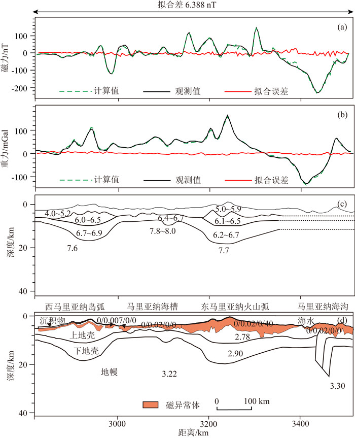
马里亚纳俯冲带的自由空间重力异常具有典型俯冲带的特征,西马里亚纳岛弧重力异常值为正值,马里亚纳海槽扩张中心轴部表现为重力异常极小值,对应较薄的地壳厚度,活动的东马里亚纳火山弧具有最高的重力异常,约为175 mGal,是剖面范围内最大的重力异常值.磁异常特征与重力异常的形态相似(图 9a),整体表现为负值,西马里亚纳岛弧磁异常值变化较平缓;马里亚纳海槽的磁异常为较低的正值,变化平缓,表现为较稳定的海盆性质;东马里亚纳火山弧的磁异常基本为正值,变化较为剧烈,是活跃的岛弧火山活动的体现.
|
图 9 马里亚纳俯冲带典型剖面的重-磁-震联合反演结果及解释 (a)该剖面的磁力拟合曲线;(b)重力拟合曲线;(c)参考的速度结构剖面,数值代表波速, 单位为km·s-1;(d)反演得到的地壳结构和异常体分布情况,单数字代表密度,单位为g·cm-3,异常体的磁化率格式为感应磁化强度/剩余磁化强度/磁倾角/磁偏角(如0.003/0/0/0),单位分别为cgs、A·m-1、(°). Fig. 9 The gravity-magnetic-seismic joint inversion and interpretation for the typical profile across Mariana Subduction Zone, in which the magnetic fitting curve 9a, the gravity fitting curve 9b, the velocity profile for reference 9c and the crustal structure and abnormal bodies distribution 9d are shown, respectively. The single numbers in 9c and 9d denote the velocity (km·s-1) and density respectively, whereas the numbers (e.g., 0.003/0/0/0) in 9d denote the induced magnetization, residual magnetization, inclination and declination of the abnormal bodies, whose units are cgs, A·m-1 and degree, respectively |
重-磁-震联合反演结果显示(图 9),西马里亚纳岛弧和东马里亚纳火山弧具有二层地壳结构,上下地壳厚度相似且具有可对比性,暗示二者原本属于同一岛弧.而且,九州—帕劳海脊的地壳结构与西马里亚纳岛弧、东马里亚纳火山弧地壳结构的相似性,很好地体现了三者的同源关系,也表明帕里西维拉盆地两侧的地壳具有共轭大陆边缘的性质(Lallemand, 2016).东马里亚纳火山弧上磁异常体的厚度、规模大于西马里亚纳岛弧.西马里亚纳岛弧地壳厚度约为17 km,东马里亚纳火山弧的莫霍面埋深略深于西马里亚纳岛弧,地壳厚度约为20 km,暗示马里亚纳海槽扩张的不对称性,扩张中心偏向现今东马里亚纳火山弧一侧.马里亚纳海槽具有正常的洋壳结构,磁异常体形成于海槽的扩张过程,地壳厚度约为7 km,在马里亚纳海槽扩张中心的轴部地区并未发现强烈拉伸减薄现象.
3 讨论 3.1 反演结果与实测数据的对比浙江地区和东海地区:华夏块体广泛存在酸性岩浆岩体的侵入和中基性岩的喷发(王懋基,1985;于津海等,2007;邓阳凡等,2011),反演结果显示规模较大的磁性体与出露于地表的大规模火成岩侵入体与实测资料吻合.华夏块体磁异常体的分布范围更大,是中生代火山岩侵入(张国全等,2012)的表现.东海陆架盆地存在厚层上古生界-第四纪的沉积物,天外天1井证实,上覆沉积物速度为1.8 ~6.0 km·s-1,厚度可达7 km(栾锡武等,2001);冲绳海槽南段地壳结构存在较大的不均一性,基底被火成岩侵入体刺穿(张训华和尚鲁宁,2014);琉球岛弧沉积物较厚,反射速度为2~4 km·s-1(高德章等,2004),反演结果基本与上述地震或钻井资料相吻合.
西菲律宾海盆:DSDP 294/295站位(Ingle et al., 1975)揭示了海盆北部薄层沉积物下的拉斑玄武岩,基底年龄较老(古新世-始新世).而且,菲律宾海板块起源于中生代地体与“冲-大东地幔柱”之间的相互作用,西菲律宾海盆北侧的冲大东海脊年龄为44~48 Ma,具有洋岛玄武岩属性,是地幔柱活动的残留(Faccenna et al., 2010; Ishizuka et al., 2011; Seton et al., 2015; Lallemand, 2016).西菲律宾海盆内的地壳年龄较老,结构复杂,因此二维反演结果显示出复杂的磁性体分布.
九州—帕劳海脊:DSDP 448站位(Kroenke et al., 1981a)揭示,中渐新世前,1.9 km的火山岩在九州—帕劳海脊上发育.随后,中渐新世,火山岩层厚度达到2.5 km,被富钾的玄武岩流和相关的角砾岩加厚了600 m.九州—帕劳海脊是曾在中渐新世活跃的残留弧,具有岛弧拉斑玄武岩属性.海脊表层磁异常体是九州—帕劳海脊活跃的火山活动的证据.
帕里西维拉海盆:DSDP 449站位(Kroenke et al., 1981b), 450站位(Kroenke et al., 1981c)分别揭示了帕里西维拉盆地西侧和东侧沉积特征及洋壳结构,DSDP 449站位揭示盆地表层沉积物较薄,在111 m钻遇拉板玄武岩;而DSDP 450站位在330 m钻遇玄武岩,上覆沉积物较厚,反演结果揭示的海盆内磁异常体是含斜长石、单斜辉石和橄榄石的玄武岩流的表现,海盆两侧沉积物厚度的差异是地壳结构不对称性的反映.
马里亚纳俯冲带:DSDP 451站位(Kroenke et al., 1981d)揭示西马里亚纳岛弧上覆沉积物较厚,以晚中新世的凝灰岩和火山角砾岩为主,下部存在~1.5 km厚的岛弧火山基底,与反演结果可对比;而DSDP 457站位(Hussong et al., 1982a),459站位(Hussong et al., 1982b)揭示,目前活跃的东马里亚纳火山弧和弧前区被较薄的松散砂质沉积覆盖,基底为多为岛弧属性的拉板玄武岩,反演结果中岛弧上大规模磁异常体对映活跃的岛弧火山岩.马里亚纳海槽形成于原马里亚纳岛弧之上,海槽上部磁异常体可能是扩张过程中形成的火山岩和玄武岩基底(DSDP 453站位, Hussong et al., 1982c; DSDP 454站位, Hussong et al., 1982d)的体现.
3.2 陆壳、洋壳的特征与联系重力异常和磁异常能够较为清晰地揭示板块的构造特征和演化阶段(Weissel and Watts, 1979; Gaina et al., 1998; Molnar et al., 1975).从磁异常和重力异常的特征来看,大陆地壳或大陆边缘弧后盆地与大洋盆地结构存在显著的差异.中国海区附近磁异常较为杂乱,暗示了复杂的地壳结构和构造运动,菲律宾海板块内磁异常表明洋盆经历了不同的扩张阶段,暗示了规律性较强的扩张活动.地壳厚度的反演结果对板块的演化也具有重要的指示意义.在西菲律宾海盆和帕里西维拉海盆内部,地壳的厚度与其年代具有明显的相关关系,由于洋壳形成后的冷却沉降,在古扩张中心两侧,随着洋壳年代的变老,地壳厚度变大.但是,对比西菲律宾海盆和帕里西维拉海盆可知,虽然后者洋壳的形成年代较新,却拥有着更大的地壳厚度,这可能是受扩张中心的扩张速率的影响(Chen et al., 1992; Bown and White, 1994),较厚的地壳暗示帕里西维拉海盆拥有较快的扩张速率.
联合反演结果能够充分展现陆壳与洋壳的特征和二者间的相互关系,浙江省地区地壳三层结构明显,莫霍面深度可达到30 km以上,岩浆作用显著,呈现出了复杂的结构特征.大陆地壳年龄较老,在漫长的地质历史时间里必然会受到构造运动(如岩浆活动、地壳运动等)的影响,地壳结构逐渐复杂化,同时,不断地发生冷却与沉降,使得地壳厚度不断地增大,对于大陆来说,结构复杂是其具有的一般特征(如Taylor and McLennan, 1985,1995; Nguuri et al., 2001).而菲律宾海板块则表现出更为简单的地壳结构,对于大洋来说,洋壳年龄较新,形成时间较短,没有经历过如陆壳那样复杂的构造运动,地壳结构较为简单,除较薄的沉积层外,一般为二层结构,厚度也明显较小.但是,陆壳与洋壳这两种不同的结构之间却有着密切的联系.例如,大洋盆地可能形成于不同的板块环境、具有不同的扩张方式.它们可以形成于大陆板块之上(如起源于中生代地体的西菲律宾海盆、东海地区的冲绳海槽),也可以形成于原有俯冲系统的岛弧之上(如帕里西维拉海盆、马里亚纳海槽).当形成于陆壳上时,盆地在初始阶段多呈现过渡壳的性质(如东海地区的冲绳海槽);当形成于岛弧上时,洋壳结构可能更容易出现,洋盆形成之后,在岩石圈的拉张作用下,地壳减薄(Mckenzie, 1978),盆地两侧可能会发育共轭大陆边缘(帕里西维拉海盆两端为共轭的岛弧结构),而且洋盆的扩张中心不一定会发生破裂,在不对称的扩张机制下可能会形成非火山型陆缘(Pérez-Gussinyé et al., 2006; Huismans and Beaumont, 2011),扩张中心没有大规模的岩浆活动.
3.3 陆壳向洋壳的转化大陆地壳与大洋地壳在结构与物质组成等方面存在显著的差异.陆壳具有三层结构,Rudnick和Fountain(1995)基于地球物理、岩石学和地球化学数据的综合分析提出,随着深度的增加,麻粒岩相变质作用导致长英质岩石中产热元素(Heat-producing elements)不断损耗,地壳中铁镁质岩石的比例有增加的趋势.因此,中地壳和下地壳岩石一般由中低级(裂谷)或高级(厚地壳区)变质矿物组成(Kearey et al., 2009).中地壳的主要成分为英云闪长质片麻岩、花岗片麻岩、斜长角闪岩,与下地壳相比含有更少的铁镁物质(Christensen and Mooney, 1995; Kearey et al., 2009).然而,洋壳具有更为简单的结构,可分为洋壳层1, 2和3,以硅镁质成分为主.洋壳层2(主要为玄武岩组分)和洋壳层3(主要为辉长岩组分)是大洋地壳的主体.因此,洋壳向陆壳的演化过程必然伴随着物质组成的变化.通常认为,洋壳的形成起源于海底扩张或陆壳大洋化(如费鼎,1983;郑永飞等,2009),岛弧地壳的张裂或洋-陆碰撞引发的板块俯冲都可能导致大洋地壳的形成.当洋壳形成时,地幔物质上涌使得陆壳结构破裂或减薄,导致硅镁质结构的出现,因此洋壳内产生广泛分布的磁性体.
另一方面,俯冲作用的发生往往受到地幔柱与板块相互作用的影响(李三忠等,2004;徐义刚等,2007).大规模地幔柱的发育,很可能是诱发板块发生俯冲的重要因素(Whattam and Stern, 2015;陆鹿等,2016).而且,地幔柱在大洋板块的演化中也扮演了重要的角色,它的出现既会导致大洋盆地的形成(如西菲律宾海盆),也可能会对板块中原有的结构产生破坏(如九州—帕劳海脊的不成熟岛弧结构),最终地幔柱作用下所产生的结构会保留在大洋盆地之中(如西菲律宾海盆中的海台).
总之,陆壳与洋壳之间不是孤立的,二者虽然结构不同,但关系密切,陆壳可能会演化出洋壳的性质,洋壳中可能会保留陆壳的结构,板块的演化总是处于动态的循环过程中(Wilson,1973).
4 结论中国海—西太平洋地区的典型剖面结构能够清晰地展现由陆壳到洋壳的典型变化.本研究利用最新的水深数据、重磁异常数据、沉积物厚度数据,并综合实测地震资料和前人地壳速度结构剖面,分析了中国海—西太平洋地区的地壳厚度变化特征,反演了典型剖面的纵向地壳结构和异常体分布情况.
(1) 陆壳或过渡壳结构:典型剖面跨越的浙江地区(扬子块体和华夏块体)、东海地区等构造单元地壳结构复杂,呈现出不同的地壳性质.其中,浙江地区(扬子块体和华夏块体)重力异常和磁异常均呈现规律的高低值相间分布,地壳具有明显的三层结构,地壳内部存在沿断裂带活动的岩浆侵入;东海地区地壳厚度小于浙江地区,但莫霍面起伏较大,冲绳海槽内地壳厚度的减薄体现了其过渡壳的性质,重磁异常的极大值代表了冲绳海槽下部的岩浆上涌.
(2) 扩张构造:典型剖面跨越的西菲律宾海盆、九州—帕劳海脊、帕里西维拉海盆等构造单元地壳结构相对简单,二层结构明显,呈现洋壳或岛弧地壳的特征.其中,西菲律宾海盆和帕里西维拉海盆内磁异常变化较为剧烈,广泛分布海盆扩张过程中形成的磁异常体,地壳厚度(~5-8 km)明显小于陆壳,西菲律宾海盆内冲大东海脊西南端的海台具有更厚的地壳(~10 km),体现洋底高原的性质;九州—帕劳海脊磁异常体形成于东、西两侧海盆的张裂过程,地壳厚度可达~20 km,中地壳缺失,呈现岛弧地壳结构.
(3) 俯冲构造:典型剖面跨越了琉球俯冲带和马里亚纳俯冲带的沟弧盆系统,揭示了二者的地壳结构特征.琉球俯冲系统中,琉球岛弧具有较厚的三层结构,弧后冲绳海槽张裂于陆壳之上,呈现过渡壳的特征;而马里亚纳俯冲系统中,岛弧地壳厚度明显小于琉球岛弧,西马里亚纳岛弧、东马里亚纳火山弧地壳结构相似,裂离于同一岛弧.西马里亚纳岛弧地壳厚度和磁异常体厚度均小于东马里亚纳火山弧,体现了古岛弧扩张过程的不对称性;马里亚纳海槽为形成于岛弧裂离过程的扩张构造,地壳厚度小于冲绳海槽,具有正常的洋壳结构,扩张中心未发生明显破裂.琉球俯冲带与马里亚纳俯冲带内岛弧、海槽地壳结构的不同体现了洋陆俯冲与洋洋俯冲过程的差异.
(4) 从浙江到马里亚纳俯冲带,地壳结构大致呈现出由厚到薄,由老到新,由复杂到简单,活动性逐渐变强的规律.因此,陆壳与洋壳之间不是孤立的,二者虽然结构不同,但关系密切,陆壳可能会演化出洋壳的性质(结构或物质组成),板块的演化总是处于动态的循环过程中.
Amante C, Eakins B W. 2009. ETOPO1 1 Arc-minute global relief model: Procedures, data sources and analysis. NOAA Technical Memorandum NESDIS NGDC-24.
|
Arisaka M, Shinohara M, Yamada T, et al. 2003. Seismic structure of uppermost mantle and crust beneath West Philippine Basin and Kyusyu-Palau ridge by seafloor borehole seismometer, OBS and airgun experiment. //American Geophysical Union, Fall Meeting 2003, Abstracts. Washington, DC: American Geophysical Union.
|
Asano S, Wada K, Yoshii T, et al. 1985. Crustal structure in the northern part of the Philippine Sea plate as derived from seismic observations of Hatoyama-off Izu Peninsula explosions. Journal of Physics of the Earth, 33(3): 173-189. DOI:10.4294/jpe1952.33.173 |
Bai Y L, Williams S E, Müller R D, et al. 2014. Mapping crustal thickness using marine gravity data:Methods and uncertainties. Geophysics, 79(2): G27-G36. DOI:10.1190/GEO2013-0270.1 |
Bai Z M, Wu Q J, Xu T, et al. 2016. Basic features of crustal structure in the lower Yangtze and its neighboring area of Chinese mainland:Review of deep seismic sounding research. Earthquake Research in China (in Chinese), 32(2): 180-192. |
Bown J W, White R S. 1994. Variation with spreading rate of oceanic crustal thickness and geochemistry. Earth and Planetary Science Letters, 121(3-4): 435-449. DOI:10.1016/0012-821X(94)90082-5 |
Chamot-Rooke N, Renard V, Le Pichon X. 1987. Magnetic anomalies in the Shikoku Basin:A new interpretation. Earth and Planetary Science Letters, 83(1-4): 214-228. DOI:10.1016/0012-821X(87)90067-7 |
Chen J, Wen N, Chen B Y. 2007. Joint inversion of gravity-magnetic-electrical-seismic combination survey:Progress and prospect. Progress in Geophysics (in Chinese), 22(5): 1427-1438. DOI:10.3969/j.issn.1004-2903.2007.05.013 |
Chen Y J. 1992. Oceanic crustal thickness versus spreading rate. Geophysical Research Letters, 19(8): 753-756. DOI:10.1029/92GL00161 |
Christensen N I, Mooney W D. 1995. Seismic velocity structure and composition of the continental crust:A global view. Journal of Geophysical Research:Solid Earth, 100(B6): 9761-9788. DOI:10.1029/95JB00259 |
Chu Y, Faure M, Lin W, et al. 2012. EarlyMesozoic tectonics of the South China block:Insights from the Xuefengshan intracontinental orogen. Journal of Asian Earth Sciences, 61: 199-220. DOI:10.1016/j.jseaes.2012.09.029 |
DengY F, Li S L, Fan W M, et al. 2011. Crustal structure beneath South China revealed by deep seismic soundings and its dynamics implications. Chinese Journal of Geophysics (in Chinese), 54(10): 2560-2574. DOI:10.3969/j.issn.0001-5733.2011.10.013 |
Deschamps A, Lallemand S. 2002. TheWest Philippine basin:An Eocene to early Oligocene back arc basin opened between two opposed subduction zones. Journal of Geophysical Research:Atmospheres, 107(B12). DOI:10.1029/2001JB001706 |
Divins D L, Rabinowitz P D. 1990. Thickness of sedimentary cover for the South Atlantic. //Udintsev G B ed. International Geological-Geophysical Atlas of the Atlantic Ocean. Moscow: Intergovernmental Oceanographic Commission, 126-127.
|
Divins D L. 2003. Total sediment thickness of the world's oceans and marginal seas. Boulder, CO: NOAA National Geophysical Data Center.
|
Faccenna C, Becker T W, Lallemand S, et al. 2010. Subduction-triggered magmatic pulses:A new class of plumes?. Earth and Planetary Science Letters, 299(1-2): 54-68. DOI:10.1016/j.epsl.2010.08.012 |
Fan X L, Lu G X, Jiang H K, et al. 1992. The crust-mantle lithosphere structure and the paleozoic basins on the northern margin of Yangtze plate. South China Journal of Seismology (in Chinese), 12(4): 46-52. DOI:10.13512/j.hndz.1992.04.006 |
Fang Y X, Liu J H. 2004. The crustal structure character of East China Sea. Donghai Marine Science (in Chinese), 22(3): 9-17. |
Fei D. 1983. On the structural feature and the oceanization in the north part of South China Sea. Acta Geophysical Sinica (in Chinese), 26(5): 459-467. |
Gaina C, Müller R D, Roest W R, et al. 1998. Theopening of the Tasman Sea:A gravity anomaly animation. Earth Interactions, 2(4): 1-23. DOI:10.1175/1087-3562(1998)002<0001:TOOTTS>2.3.CO;2 |
Gao D Z, Zhao J H, Bo Y L, et al. 2004. A profile study of gravitative-magnetic and seismic comprehensive survey in the East China Sea. Chinese Journal of Geophysics (in Chinese), 47(5): 853-861. |
Goodman D. 1983. Seismic refraction survey of crustal and upper mantle structures in the West Philippine Basin. Corvallis, OR: Oregon State University.
|
Goodman D, Bibee L D, Dorman L M. 1989. Crustal Seismic Structure Beneath The West Philippine Sea, 17°-18° North. Marine Geophysical Researches, 11(3): 155-168. DOI:10.1007/BF00340202 |
Han B. 2008. Geophysical field and deep tectonic features of East China Sea (in Chinese). Qingdao: The Institute of Oceanology, Chinese Academy of Sciences.
|
Hao T Y, Xu Y, Xu Y, et al. 2006. Some new understandings on deep structure in Yellow Sea and East China Sea. Chinese Journal of Geophysics (in Chinese), 49(2): 458-468. DOI:10.1002/cjg2.v49.2 |
Hayes D E, Labrecque J L. 1991. Sediment isopachs: Circum-Antarctic to 30°S. //Hayes D E ed. Marine Geological and Geophysical Atlas of the Circum-Antarctic to 30°S. Washington, DC: American Geophysical Union, 29-33.
|
Hickey-Vargas R. 2005. Basalt and tonalite from the Amami Plateau, northern West Philippine Basin:New Early Cretaceous ages and geochemical results, and their petrologic and tectonic implications. Island Arc, 14(4): 653-665. DOI:10.1111/j.1440-1738.2005.00474.x |
Hilde T W C, Lee C S. 1984. Origin and evolution of the West Philippine Basin:A new interpretation. Tectonophysics, 102(1-4): 85-104. DOI:10.1016/0040-1951(84)90009-X |
Hu L T, Hao T Y, Xing J, et al. 2016. The Moho depth in the China Sea-West Pacific and its geological implications. Chinese Journal of Geophysics (in Chinese), 59(3): 871-883. DOI:10.6038/cjg20160310 |
Huismans R, Beaumont C. 2011. Depth-dependent extension, two-stage breakup and cratonic underplating at rifted margins. Nature, 473(7345): 74-78. DOI:10.1038/nature09988 |
Hussong D M, Uyeda S, Blanchet R, et al. 1982a. Site 457: Mariana island arc. //Hussong D M, Uyeda S, Blanchet R, et al eds. Initial Reports of the Deep Sea Drilling Project. Washington, DC: U. S. Government Printing Office, 60: 255-261, doi: 10.2973/dsdp.proc.60.113.1982.
|
Hussong D M, Uyeda S, Blanchet R, et al. 1982b. Site 459: Mariana fore-arc. //Hussong D M, Uyeda S, Blanchet R, et al eds. Initial Reports of the Deep Sea Drilling Project. Washington, DC: U. S. Government Printing Office, 60: 309-369, doi: 10.2973/dsdp.proc.60.115.1982.
|
Hussong D M, Uyeda S, Blanchet R, et al. 1982c. Site 453: West side of the Mariana trough. //Hussong D M, Uyeda S, Blanchet R, et al eds. Initial Reports of the Deep Sea Drilling Project. Washington, DC: U. S. Government Printing Office, 60: 101-167, doi: 10.2973/dsdp.proc.60.108.1982.
|
Hussong D M, Uyeda S, Blanchet R, et al. 1982d. Site 454: Near the center of the Mariana Trough. //Hussong D M, Uyeda S, Blanchet R, et al eds. Initial Reports of the Deep Sea Drilling Project. Washington, DC: U. S. Government Printing Office, 60: 169-202, doi: 10.2973/dsdp.proc.60.109.1982.
|
Ingle J C Jr, Karing D E, Bouma A H, et al. 1975. Site 294/295. //Ingle J C Jr, Karing D E, Bouma A H et al eds. Initial Reports of the Deep Sea Drilling Project. Washington, DC: U. S. Government Printing Office, 31: 169-189, doi: 10.2973/dsdp.proc.31.106.1975.
|
Ishizuka O, Taylor R N, Yuasa M, et al. 2011. Making and breaking an island arc:A new perspective from the Oligocene Kyushu-Palau arc, Philippine Sea. Geochemistry, Geophysics, Geosystems, 12(5): Q05005. DOI:10.1029/2010GC003440 |
Jiang W W, Liu S H, Hao T Y, et al. 2003. Character of geophysical field and crustal structure of Okinawa Trough and adjacent region. Progress in Geophysics (in Chinese), 18(2): 287-292. DOI:10.3969/j.issn.1004-2903.2003.02.017 |
Jin C, Qian J F, Zhou L Y, et al. 2015. Structural system and decoupling between deep and shallow in lithosphere of Zhejiang province-from gravity and magentic field characteristics. Bulletin of Science and Technology (in Chinese), 31(1): 27-33. DOI:10.13774/j.cnki.kjtb.2015.01.007 |
Karig D E. 1972. Remnant arcs. Geological Society of America Bulletin, 83(4): 1057-1068. DOI:10.1130/0016-7606(1972)832.0.CO;2 |
Kearey P, Klepeis K A, Vine F J. 2009. Global Tectonics. 3rd ed. Hoboken, NJ: Wiley-Blackwell.
|
Kong X R, Xiong S B, Zhou W X, et al. 1995. New progress on deep geophysical research in Zhejiang:Geological sections of Tunxi-Wenzhou and Zhuji-Linhai and the achivements of their regioral gravity. Geology of Zhejiang (in Chinese), 11(1): 50-62. |
Kroenke L, Scott R, Balshaw K, et al. 1981a. Site 448: Palau-Kyushu ridge. //Kroenke L, Scott R, Balshaw K, et al eds. Initial Reports of the Deep Sea Drilling Project. Washington, DC: U. S. Government Printing Office, 59: 111-319, doi: 10.2973/dsdp.proc.59.103.1981.
|
Kroenke L, Scott R, Balshaw K, et al. 1981b. Site 449: West side of the Parece Vela Basin. //Kroenke L, Scott R, Balshaw K, et al eds. Initial Reports of the Deep Sea Drilling Project. Washington, DC: U. S. Government Printing Office, 59: 321-353, doi: 10.2973/dsdp.proc.59.104.1981.
|
Kroenke L, Scott R, Balshaw K, et al. 1981c. Site 450: East side of the Parece Vela Basin. //Kroenke L, Scott R, Balshaw K, et al eds. Initial Reports of the Deep Sea Drilling Project. Washington, DC: U. S. Government Printing Office, 59: 355-403, doi: 10.2973/dsdp.proc.59.105.1981.
|
Kroenke L, Scott R, Balshaw K, et al. 1981d. Site 451: East edge of the West Mariana Ridge. //Kroenke L, Scott R, Balshaw K et al eds. Initial Reports of the Deep Sea Drilling Project. Washington, DC: U. S. Government Printing Office, 59: 405-483, doi: 10.2973/dsdp.proc.59.106.1981.
|
Lallemand S. 2016. Philippine Sea Plate inception, evolution, and consumption with special emphasis on the early stages of Izu-Bonin-Mariana subduction. Progress in Earth and Planetary Science, 3: 15. DOI:10.1186/s40645-016-0085-6 |
Le J Y, Xu W L. 1992. A introduction of crustal structure in the East China Sea. Chinese Geology, (6): 29-30. |
LePichon X. 1969. Models and structure of the oceanic crust. Tectonophysics, 7(5-6): 385-401. DOI:10.1016/0040-1951(69)90008-0 |
Li S Z, Hou F H, Lü H Q, et al. 2004. Interactions of ridge-plume, plume-trench and trench-ridge. Marine Geology Letters (in Chinese), 20(11): 1-5. DOI:10.16028/j.1009-2722.2004.11.001 |
LiY K, Dong S W, Zhang Z J, et al. 2002. Poisson's ratio structure of the crust and UHP metamorphic zone in the Dabie Orogenic Belt-A suggestion from wide-angle and subvertical seismic reflection sounding. Geological Review (in Chinese), 48(1): 15-23. DOI:10.16509/j.georeview.2002.01.004 |
Lin Z, Zhang L, Zhong G J. 2013. The application of gravity magnetic seismic joint inversion to the comprehensive interpretation of geophysics in the northern South China Sea. Geophysical and Geochemical Exploration (in Chinese), 37(6): 968-975. DOI:10.11720/j.issn.1000-8918.2013.6.02 |
Liu G D. 1998. Geology of China Sea and its Adjacent Area. Beijing: Geological Publishing House.
|
Liu G D. 2007. Geophysical fields and hydrocarbon resources of China seas. Progress in Geophysics (in Chinese), 22(4): 1229-1237. DOI:10.3969/j.issn.1004-2903.2007.04.032 |
Lu L, Yan L L, Li Q H, et al. 2016. Oceanic plateau and its significances on the Earth system:A review. Acta Petrologica Sinica (in Chinese), 32(6): 1851-1876. |
Luan X W, Gao D Z, Yu P Z, et al. 2001. The crust velocity structure of a profile in the area of East China Sea and its vicinity. Progress in Geophysics (in Chinese), 16(2): 28-34. DOI:10.3969/j.issn.1004-2903.2001.02.004 |
Ludwig W J, Houtz R E, Delach M, et al. 1980. Isopach Map of Sediments in the Pacific Ocean Basin and Marginal Sea Basins. USA, School of Geosciences Faculty and Staff Publications, 246.
|
Luo D, Zhang X H, Cai F, et al. 2014. Integrated gravity-magnetic-seismic data inversion and interpretation and their application to underwater tectonics. Marine Geology & Quaternary Geology (in Chinese), 34(6): 135-143. |
McKenzie D. 1978. Some remarks on the development of sedimentary basins. Earth and Planetary Science Letters, 40(1): 25-32. DOI:10.1016/0012-821X(78)90071-7 |
Molnar P, Atwater T, Mammerickx J, et al. 1975. Magnetic Anomalies, bathymetry and the tectonic evolution of the South Pacific since the Late Cretaceous. Geophysical Journal International, 40(3): 383-420. DOI:10.1111/j.1365-246X.1975.tb04139.x |
Mrozowski C L, Hayes D E. 1979. The evolution of the Parece Vela Basin, eastern Philippine Sea. Earth and Planetary Science Letters, 46(1): 49-67. DOI:10.1016/0012-821X(79)90065-7 |
Murauchi S, Den N, Asano S, et al. 1968. Crustal structure of the Philippine Sea. Journal of Geophysical Research, 73(10): 3143-3171. DOI:10.1029/JB073i010p03143 |
Nguuri T K, Gore J, James D E, et al. 2001. Crustal structure beneath southern Africa and its implications for the formation and evolution of the Kaapvaal and ZimbabweCratons. Geophysical Research Letters, 28(1): 2501-2504. DOI:10.1029/2000GL012587 |
Nishizawa A, Kaneda K, Katagiri Y, et al. 2007. Variation in crustal structure along the Kyushu-Palau Ridge at 15-21°N on the Philippine Sea plate based on seismic refraction profiles. Earth, Planets and Space, 59(6): e17-e20. DOI:10.1186/BF03352711 |
Nishizawa A, Kaneda K, Oikawa M. 2009. Seismic structure of the northern end of the Ryukyu Trench subduction zone, southeast of Kyushu, Japan. Earth, Planets and Space, 61(8): e37-e40. DOI:10.1186/BF03352942 |
Nishizawa A, Kaneda K, Katagiri Y, et al. 2014. Wide-angle refraction experiments in the Daito Ridges region at the northwestern end of the Philippine Sea plate. Earth, Planets and Space, 66: 25. DOI:10.1186/1880-5981-66-25 |
Okino K, Shimakawa Y, Nagaoka S. 1994. Evolution of the Shikoku Basin. Earth, Planets and Space, 46(6): 463-479. DOI:10.5636/jgg.46.463 |
Okino K, Kasuga S, Ohara Y. 1998. A new scenario of the Parece Vela Basin Genesis. Marine Geophysical Researches, 20(1): 21-40. DOI:10.1023/A:1004377422118 |
Pérez-Gussinyé M, Morgan J P, Reston T J, et al. 2006. The rift to drift transition at non-volcanic margins:Insights from numerical modelling. Earth and Planetary Science Letters, 244(1-2): 458-473. DOI:10.1016/j.epsl.2006.01.059 |
Rudnick R L, Fountain D M. 1995. Nature and composition of the continental crust:A lower crustal perspective. Reviews of Geophysics, 33(3): 267-309. DOI:10.1029/95RG01302 |
Sandwell D T, Müller R D, Smith W H F, et al. 2014. New global marine gravity model from CryoSat-2 and Jason-1 reveals buried tectonic structure. Science, 346(6205): 65-67. DOI:10.1126/science.1258213 |
Seton M, Flament N, Whittaker J, et al. 2015. Ridge subduction sparked reorganization of the Pacific plate-mantle system 60-50 million years ago. Geophysical Research Letters, 42(6): 1732-1740. DOI:10.1002/2015GL063057 |
Shervais J W, Choi S H. 2012. Subduction initiation along transform faults:The proto-Franciscan subduction zone. Lithosphere, 4(6): 484-496. DOI:10.1130/L153.1 |
Stern R J, Fouch M J, Klemperer S L. 2003. An overview of the Izu-Bonin-Mariana subduction factory. //Eiler J ed. Inside the Subduction Factory. Washington, DC: American Geophysical Union, 138: 175-222, doi: 10.1029/138GM10.
|
Stern R J, Reagan M, Ishizuka O, et al. 2012. To understand subduction initiation, study forearc crust:To understand forearc crust, study ophiolites. Lithosphere, 4(6): 469-483. DOI:10.1130/L183.1 |
Takahashi N, Kodaira S, Klemperer S L, et al. 2007. Crustal structure and evolution of the Mariana intra-oceanic island arc. Geology, 35(3): 203-206. DOI:10.1130/G23212A.1 |
Taylor S R, McLennan B. 1985. The Continental Crust:Its Composition and Evolution. Oxford: Blackwell Scientific Publication.
|
Taylor S R, McLennan S M. 1995. The geochemical evolution of the continental crust. Reviews of Geophysics, 33(2): 241-265. DOI:10.1029/95RG00262 |
Teng J W. 2008. The prelude to the research of fine structures of crust and upper mantle and continental dynamics in China:Its development trends and enlightenment from deep seismic reflection exploration of the Qaidam basin in 1958. Progress in Geophysics (in Chinese), 23(1): 1-13. |
Wang C Y, Lou H, Wang F. 1999. Crustal structure in the Dabieshan UHP metamorphic belt and its tectonic implication. Acta Seismologica Sinica (in Chinese), 21(5): 533-544. |
Wang M J. 1985. An investigation into the crustal structure of South China in terms of gravity field. Geophysical & Geochemical Exploration (in Chinese), 9(3): 161-169. |
Weissel J K, Watts A B. 1979. Tectonic evolution of the Coral Sea Basin. Journal of Geophysical Research:Solid Earth, 84(B9): 4572-4582. DOI:10.1029/JB084iB09p04572 |
Whattam S A, Stern R J. 2015. Late Cretaceous plume-induced subduction initiation along the southern margin of the Caribbean and NW South America:The first documented example with implications for the onset of plate tectonics. Gondwana Research, 27(1): 38-63. DOI:10.1016/j.gr.2014.07.011 |
Wilson J T. 1973. Mantle plumes and plate motions. Tectonophysics, 19(2): 149-164. DOI:10.1016/0040-1951(73)90037-1 |
Xu Y G, He B, Huang X L, et al. 2007. The debate over mantle plumes and how to test the plume hypothesis. Earth Science Frontiers (in Chinese), 14(2): 1-9. DOI:10.1016/S1872-5791(07)60011-6 |
Yang W C, Chen Z X, Hou Z Z, et al. 2016. Crustal density structures around Chinese continent by inversion of satellite gravity data. Acta Geologica Sinica (in Chinese), 90(9): 2167-2175. |
Yu J F, Jiang W W, Hao T Y, et al. 2015. Lithosphere structure and geodynamics characteristics of China eastern seas and adjacent region. Progress in Geophysics (in Chinese), 30(3): 1100-1109. DOI:10.6038/pg20150314 |
Yu J H, O'Reilly Y S, Wang L J, et al. 2007. Finding of ancient materials in Cathaysia and implication for the formation of Precambrian crust. Chinese Science Bulletin, 52(1): 13-22. DOI:10.1007/s11434-007-0008-4 |
Zahirovic S, Seton M, Müller R D. 2014. The Cretaceous and Cenozoic tectonic evolution of Southeast Asia. Solid Earth, 5(1): 227-273. DOI:10.5194/se-5-227-2014 |
Zhang G Q, Wang Q S, Yu Y P, et al. 2012. Stratigraphic age and subdivision of volcanic rocks in eastern Zhejiang. Journal of Stratigraphy (in Chinese), 36(3): 641-652. |
Zhang G W, Guo A L, Wang Y J, et al. 2013. Tectonics of South China continent and its implications. Science China Earth Sciences, 43(10): 1553-1582. DOI:10.1007/s11430-013-4679-1 |
Zhang J, Li J B, Ding W W. 2012. Reviews of the study on crustal structure and evolution of the Kyushu-Palau Ridge. Advances in Marine Science (in Chinese), 30(4): 595-607. |
Zhang X H, Shang L N. 2014. Study on crustal structure and nature of the Okinawa Trough. Periodical of Ocean University of China (in Chinese), 44(6): 72-80. |
Zhang Z J, Bai Z M, Wang C Y, et al. 2005. Crustal structure of Gondwana-and Yangtze-typed blocks:An example by wide-angle seismic profile from Menglian to Malong in western Yunnan. Science China Series D:Earth Sciences, 48(11): 1828-1836. DOI:10.1360/03yd0547 |
Zheng Y F, Ye K, Zhang L F. 2009. Developing the plate tectonics from oceanic subduction to continental collision. Chinese Science Bulletin, 54(15): 2549-2555. |
白志明, 吴庆举, 徐涛, 等. 2016. 中国大陆下扬子及邻区地壳结构基本特征:深地震测深研究综述. 中国地震, 32(2): 180-192. |
陈洁, 温宁, 陈邦彦. 2007. 重磁电震联合反演研究进展与展望. 地球物理学进展, 22(5): 1427-1438. DOI:10.3969/j.issn.1004-2903.2007.05.013 |
邓阳凡, 李守林, 范蔚茗, 等. 2011. 深地震测深揭示的华南地区地壳结构及其动力学意义. 地球物理学报, 54(10): 2560-2574. DOI:10.3969/j.issn.0001-5733.2011.10.013 |
范小林, 陆国新, 蒋洪堪, 等. 1992. 扬子板块北缘壳(慢)岩石圈结构与古生代盆地. 华南地震, 12(4): 46-52. DOI:10.13512/j.hndz.1992.04.006 |
方银霞, 刘建华. 2004. 东海的地壳结构特征. 东海海洋, 22(3): 9-17. |
费鼎. 1983. 南海北部区域构造和陆壳向洋壳的转化. 地球物理学报, 26(5): 459-467. |
高德章, 赵金海, 薄玉玲, 等. 2004. 东海重磁地震综合探测剖面研究. 地球物理学报, 47(5): 853-861. |
韩波. 2008. 东海地球物理场及深部地质构造研究. 青岛: 中国科学院研究生院(海洋研究所).
|
郝天珧, 徐亚, 胥颐, 等. 2006. 对黄海-东海研究区深部结构的一些新认识. 地球物理学报, 49(2): 458-468. |
胡立天, 郝天珧, 邢健, 等. 2016. 中国海-西太平洋莫霍面深度分布特征及其地质意义. 地球物理学报, 59(3): 871-883. DOI:10.6038/cjg20160310 |
江为为, 刘少华, 郝天珧, 等. 2003. 冲绳海槽及其邻域地球物理场与地壳结构特征. 地球物理学进展, 18(2): 287-292. DOI:10.3969/j.issn.1004-2903.2003.02.017 |
孔祥儒, 熊绍伯, 周文星, 等. 1995. 浙江省深部地球物理研究新进展-屯溪-温州、诸暨-临海地学断面及区域重力研究成果. 浙江地质, 11(1): 50-62. |
乐俊英, 许薇龄. 1992. 东海地壳结构构造简介. 中国地质, (6): 29-30. |
李三忠, 侯方辉, 吕海青, 等. 2004. 洋中脊-地幔柱、地幔柱-海沟与海沟-洋中脊相互作用. 海洋地质动态, 20(11): 1-5. DOI:10.16028/j.1009-2722.2004.11.001 |
李英康, 董树文, 张中杰, 等. 2002. 大别造山带地壳泊松比结构与超高压变质带-来自宽角反射与近垂直反射剖面的启示. 地质论评, 48(1): 15-23. DOI:10.16509/j.georeview.2002.01.004 |
林珍, 张莉, 钟广见. 2013. 重磁震联合反演在南海东北部地球物理解释中的应用. 物探与化探, 37(6): 968-975. DOI:10.11720/j.issn.1000-8918.2013.6.02 |
刘光鼎. 1998. 中国海区及邻域地质-地球物理系列图-1:5000000. 北京: 地质出版社.
|
刘光鼎. 2007. 中国海地球物理场与油气资源. 地球物理学进展, 22(4): 1229-1237. DOI:10.3969/j.issn.1004-2903.2007.04.032 |
陆鹿, 严立龙, 李秋环, 等. 2016. 洋底高原及其对地球系统意义研究综述. 岩石学报, 32(6): 1851-1876. |
栾锡武, 高德章, 喻普之, 等. 2001. 中国东海及邻近海域一条剖面的地壳速度结构研究. 地球物理学进展, 16(2): 28-34. DOI:10.3969/j.issn.1004-2903.2001.02.004 |
骆迪, 张训华, 蔡峰, 等. 2014. 重磁震联合反演及综合解释在海域构造解释中的应用. 海洋地质与第四纪地质, 34(6): 135-143. |
滕吉文. 2008. 中国地壳、上地幔精细结构和大陆动力学研究的序幕-从1958年柴达木沉积盆地深部地震反射探测看半个世纪来该科学领域的发展导向和启迪. 地球物理学进展, 23(1): 1-13. |
王椿镛, 楼海, 王飞. 1999. 大别山超高压变质带地壳结构及其构造意义. 地震学报, 21(5): 533-544. |
王懋基. 1985. 根据重力场研究华南地壳结构. 物探与化探, 9(3): 161-169. |
徐义刚, 何斌, 黄小龙, 等. 2007. 地幔柱大辩论及如何验证地幔柱假说. 地学前缘, 14(2): 1-9. |
杨文采, 陈召曦, 侯遵泽, 等. 2016. 从卫星重力资料看中国及邻区地壳密度结构. 地质学报, 90(9): 2167-2175. |
于津海, O'ReillyY S, 王丽娟, 等. 2007. 华夏地块古老物质的发现和前寒武纪地壳的形成. 科学通报, 52(1): 11-18. |
余景锋, 江为为, 郝天珧, 等. 2015. 中国东部海区及其邻域岩石层结构与地球动力学特征研究. 地球物理学进展, 30(3): 1100-1109. DOI:10.6038/pg20150314 |
张国全, 王勤生, 俞跃平, 等. 2012. 浙江东部火山岩地区的地层时代和划分. 地层学杂志, 36(3): 641-652. |
张国伟, 郭安林, 王岳军, 等. 2013. 中国华南大陆构造与问题. 中国科学:地球科学, 43(10): 1553-1582. DOI:10.1007/s11430-013-4679-1 |
张洁, 李家彪, 丁巍伟. 2012. 九州-帕劳海脊地壳结构及其形成演化的研究综述. 海洋科学进展, 30(4): 595-607. |
张训华, 尚鲁宁. 2014. 冲绳海槽地壳结构与性质研究进展和新认识. 中国海洋大学学报, 44(6): 72-80. |
郑永飞, 叶凯, 张立飞. 2009. 发展板块构造:从洋壳俯冲到大陆碰撞. 科学通报, 54(13): 1799-1803. |
 2018, Vol. 61


