 2018, Vol. 61


2. 中国科学院大学, 北京 100049
2. University of Chinese Academy of Sciences, Beijing 100049, China
普遍的观点认为, 中高层大气重力波(AGWs)产生于低层大气(Taylor and Hapgood, 1988).在向上传播过程中, 重力波携带的动量和能量会沉淀到平均流中, 对中层-低热层大气环流的调制起到重要作用(Vincent, 1984; Hamilton, 1996; Fritts and Alexander, 2003).Fritts和Vincent(1987)的研究表明, 中层顶区附近的重力波(GWs)通量主要来自于高频重力波(GWs), 即观测周期 < 1 h和水平波长 < 100 km的重力波(Taylor et al., 1995).目前, 这些高频的重力波已经被广泛使用气辉成像观测数据进行了研究.
对流活动, 尤其是对流层区域的对流活动, 被普遍认为是产生高频重力波的重要波源之一(Taylor and Hapgood, 1988; Suzuki et al., 2007; Li et al., 2016).另外, 中层-低热层大气重力波的产生机制还包括:地形(Nastrom and Fritts, 1992), 剪切不稳定性(Lott, 1997; Li et al., 2016), 动力学不稳定性(Wrasse et al., 2009), 急流(Shiokawa et al., 2007).
反射线追踪技术被广泛运用于中层大气重力波(AGWs)波源的研究(Bertin et al., 1978; Hertzog et al., 2001; Wrasse et al., 2003, 2004, 2006a, 2006b).
本篇文章, 利用中国东港(40.0°N, 124.0°E)台站于2013年9月15—16日的OH气辉成像数据报道了两个重力波事件(1和2).且利用反射线追踪方法, 研究了这两个重力波事件的产生源.同时结合SABER/TIMED卫星的温度数据, MTSAT卫星的红外云图数据, ECMWF的垂直速度Omega(Pa·s-1)和风场参数, 十三陵(40.3°N, 116.2°E)台站的多普勒流星雷达在70~110 km高度的风场数据, 以及MERRA的风场数据, 分析了观测的两个重力波的产生机制和传播环境.
1 观测数据和处理方法研究的重力波事件1和事件2来自东港台站的OH全天空气辉成像观测.该全天空气辉成像仪属于国家空间科学中心重点实验室.其由一个稳定的温度转动轮组成, 使用具有180°大视场的Nikon 16 mm/2.8D鱼眼透镜和1024像素×1024像素的CCD成像仪.气辉成像仪的观测由电脑软件自动控制, 其曝光时间约是1 min.
由于OH全天空气辉成像仪使用鱼眼透镜(导致观测的原始图像发生扭曲,尤其在图像边沿处), 且观测图像被星光污染.因此, 在提取重力波参数前, 我们需要对原始图像进行如下预处理.第一步, 利用标准星图对原始图像进行定标校正(Garcia et al., 1997).第二步, 去除Van Rhijin和大气消光效应(Kubota et al., 2001).第三步, 利用中值滤波法去除星光的污染(Coble et al., 1998).第四步, 假设OH气辉层的高度为87 km, 将观测图像投影到地理坐标系中(王翠梅等, 2014, 2016).第五步, 将连续的两幅图像差分获取TD图.最后, 利用2-D FFT谱分析方法提取重力波参数, 包括水平波长, 观测周期, 水平相速度和方位角(Coble et al., 1998).
多普勒流星雷达位于北京十三陵(40.3°N, 116.2°E), 仪器用于观测的频率是38.9 MHz, 使用7.5 kW的传输能谱(Holdsworth et al., 2004).流星雷达探测的高度在70~110 km范围,其时间和高度的分辨率分别是1 h和2 km.热层-电离层-中层能量和动力学探测仪(TIMED), 其最初的目的是探测热层的结构和60~180 km高度范围的能量收支情况.SABER是TIMED卫星上的探测仪器之一,其通过探测从地面到约120 km高度范围的15 μm的CO2辐射, 进而反演获得温度参数.SABER使用的是从1.27 μm到16 μm范围的10个通道的宽带辐射计.Mertens等(2001)中详细地介绍了关于从CO2辐射反演为温度参数的方法.表 1表明, 事件1和事件2的观测时间段分别是23:40—03:58和01:39—03:58.
|
|
表 1 基于东港台站的OH气辉成像仪观测的重力波事件1和2的时间段 Table 1 The local time of these two GW events obtained from OH all-sky airglow imager, located at Donggang |
图 1是于2013年9月15—16日晚03:52:02 LT在东港台站观测的两个重力波事件1和2的观测图像.图 1a中, 大的矩形区域对应的是事件1, 小的矩形区域对应的是事件2.为了方便提取观测的两个重力波的参数, 选取了两个矩形区域1(图 1b)和2(图 1d),分别对应于事件1和2.然后, 利用二维FFT提取重力波参数, 包括水平波长(λh), 观测周期(Tobs), 水平相速度(vobs)和方位角.图 1c和1e分别是对应于图 1b和1d的能谱图.表 2给出了观测的两个重力波的平均参数.为了分析观测的重力波的传播特征, 我们利用Isler等(1997)介绍的色散关系计算了垂直波长(λz).从表 2中我们发现事件1的λh, Tobs, vobs, 方位角和垂直波长分别是42.6 km, 8.5 min, 83.5 m·s-1, 8°和12.4 km.事件2的λh, Tobs, vobs, 方位角和垂直波长分别是37.5 km, 7.8 min, 80.1 m·s-1, 302°和10.6 km.

|
图 1 2013年9月15—16日晚03:52:02 LT在东港台站观测的OH气辉差分图像 (a)投影到800 km×800 km地理坐标系下的差分图像; (b)对应于事件1的矩形区域; (c)对应于图 1b的能谱图; (d)对应于事件2的矩形区域; (e)对应于图 1d的能谱图. Fig. 1 An example of the OH airglow imager observed at Donggang, taken on 03:52:02 LT on 16 September, 2013 (a) An image projected on to 800 km×800 km geographic coordinate; (b) The rectangular area of the event 1; (c) The power spectrum of figure 1b; (d) The rectangular area of the event 2; (e) The power spectrum of Fig. 1d. |
|
|
表 2 于2013年9月15—16日晚在东港台站观测的重力波事件1和2的平均参数值 Table 2 The averaged parameters of these two observed GW events occurred on 15—16 September, 2013 |
在反射线追踪方法中, 将表 2中的观测水平波长(λh), 传播方向(azimuth), 水平相速度(vobs)和观测周期(Tobs), 以及表 3中的观测时间02:48 LT (事件1)和03:30 LT (事件2), 作为起始参数输入模型中.同时, 反射线追踪模型中也使用了水平风速和温度参数.水平风场速度参数在70~110 km高度范围来自十三陵(40.3°N, 116.2°E)的流星雷达观测, 70 km以下来自MERRA再分析资料.反射线追踪模型使用的温度参数来自39.4°N, 130.6°E的SABER/TIMED卫星观测.图 2a表明, 中层顶区域没有明显的热导管.图 2a也给出了利用公式(2)计算的浮力频率的平方(N2).图 2b和2c分别是来自十三陵(40.3°N, 116.2°E)台站观测的纬向风和经向风的剖面图.通过方程(1),结合SABER卫星的温度参数(图 2a)和流星雷达的风场速度(图 2b—2c),计算了垂直波数的平方(m2).图 2d表明,事件1在01:00-03:00 LT时间段是自由传播的(m2>0).图 2e表明, 事件2在00:00 -03:00 LT时间段是自由传播的.

|
图 2 (a) 来自SABER/TIMED卫星观测的温度剖面图及其计算的N2剖面图;(b)来自流星雷达的纬向风速剖面图;(c)来自流星雷达的经向风速剖面图;(d)事件1的垂直波数平方剖面图;(e)事件2的垂直波数平方剖面图.图 2b-2d中,绿线表示00:00 LT, 红线表示01:00 LT, 蓝线表示02:00 LT, 紫线表示03:00 LT Fig. 2 (a) The profile of temperature and N2 from SABER/TIMED; (b) The profile of meteor radar wind velocity in zonal direction; (c) The profile of meteor radar wind velocity in meridional direction; (d) Vertical wave number m2 of event 1; (e) vertical wave number m2 of event 2.In Fig. 2b—2d, the green line represents 00:00 LT, the red represents 01:00 LT, the blue line represents 02:00 LT, the purple line represents 03:00 LT |
反射线追踪模型中, 使用的时间步长是δt=100 m/Cgz, 100 m是高度方向上的步长, Cgz是垂直群速度.重力波在垂直方向上的传播条件通过方程(1)表示的色散关系来决定:
|
(1) |
|
|
表 3 关于事件1和2的反射线追踪结果 Table 3 The results of the reverse ray tracing of GW events occurred on the night of 15—16 September, 2013 |
|
(2) |
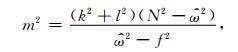
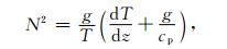
方程(1)和(2)分别是垂直波数的平方和浮力平方.其中, 
反射线追踪模型中的运行截止条件为:(1) m2 < 0, 此时重力波不能垂直向上传播; (2) m2>1×10⁶ (cyc2·m-2), 此时垂直波数小于1 km, 即重力波接近于临界层; (3) |m|→∞, 此时重力波的波包会破碎.由于垂直群速度和浮力频率的平方值在对流层附近变得很小, 导致垂直波数的平方m2 < 0.反射线追踪的结果表明, 事件1和事件2分别产生于16.4 km和12.7 km高度.表 3中, 事件1在反射线追踪模型中使用的初始时间是02:48 LT, 经追踪后获得其产生时间是00:10 LT, 产生的位置位于39.3°N, 117.2°E, 其距离东港大约755 km.然而, 事件2在反射线追踪模型中使用的观测时间是03:30 LT, 经追踪后获得其产生时间是00:21 LT, 产生的位置位于47.1°N, 121.3°E, 其距离东港大约883 km.
2.2 观测的两重力波的产生机制分析目前, 大多数观点认为, 对流活动是中高层大气重力波的重要产生源(Walterscheid et al., 1999; Nakamura et al., 2003).且由Multi-function Transport Satellite(MTSAT)卫星观测的红外云图可以很好地反应大气的对流活动(Suzuki e al., 2013).为了探究观测的重力波的产生源, 图 3a—3c呈现了由MTSAT卫星于2013年9月15—16日晚分别在23:06 LT, 00:06 LT和01:06 LT观测的红外云图.结果表明, 在事件1的波源位置偏西处, 存在强烈的对流活动, 其与事件1的波源位置吻合较好.然而, 在事件2的波源位置附近, 存在较小对流活动(相对于事件1), 其可能对事件2的产生具有一定作用.文章中, 红外云图来自http://weather.is.kochi-u.ac.jp/archive-e.html.

|
图 3 来自MTSAT卫星于2013年9月15—16日晚观测的红外云图 (a) 23:06 LT; (b) 00:06 LT; (c) 01:06 LT.红色圈和红色星分别表示反射线追踪获得的事件1和事件2的波源位置. Fig. 3 The infrared cloud images from MTSAT on the night of 15—16 September, 2013 (a) 23:06 LT; (b) 00:06 LT; (c) 01:06 LT.Here, the red circle and red star represent the wave source locations traced by reverse ray tracing of event 1 and event 2, respectively. |
Omega(Pa·s-1)参数可以反映出大气垂直运动的不稳定性(Wrasse et al., 2009).图 4给出Omega参数于2013年9月15—16日晚分别在20:00 LT和02:00 LT,且位于300 hPa (~9.2 km)高度的分布.Omega参数是负值(正值)表示大气向上(向下)运动.结果表明, 事件2附近的大气具有向上运动的趋势, 其对事件2的产生可能有一定作用.然而, 反射线追踪获得的事件1的波源位置位于向上和向下运动的过渡区域,其产生的不稳定性也可能对事件1的产生具有一定作用.这里, Omega参数来自ECMWF再分析资料, 其观测包括自1000 hPa到1 hPa高度的37个垂直分布层, 空间分辨率为0.75°纬度×0.75°经度.

|
图 4 位于300 hPa高度的Omega分布图 (a) 20:00 LT;(b) 02:00 LT.其中,红色圈和红色星分别表示反射线追踪获得的事件1和事件2的波源位置. Fig. 4 Showing the distributions of the data of Omega at 300 hPa (a) 20:00 LT; (b) 02:00 LT.Here, the red circle and red star represent the wave source locations by reverse ray tracing of event 1 and event 2, respectively. |
为了更详细地研究观测的重力波(事件1和事件2)波源附近的风场情况,图 5a和5b分别给出2013年9月15—16日晚在20:00 LT和02:00 LT, 且位于300 hPa高度的风场结构示意图.结果表明, 事件2附近的风场具有向东南方向传播的趋势.然而, 事件1的波源位置位于西北风和西风的交界处.

|
图 5 ECMWF于2013年9月15—16日晚在300 hPa高度处的风场结构示意图 (a) 20:00 LT; (b) 02:00 LT.其中, 红色圈和红色星分别表示反射线追踪获得的事件1和事件2的波源位置. Fig. 5 The wind field structures in the height of 300 hPa, on the night of 15—16 September, 2013 (a) 20:00 LT; (b) 02:00 LT.The red circle and red star represent the wave source locations traced by reverse ray tracing model of event 1 and event 2, respectively. |
以上分析表明, 事件1的波源位置与其西侧的强烈的对流运动和大气向上向下运动产生的不稳定性吻合较好.然而, 对流运动和300 hPa高度处的大气的向上运动可能对事件2的产生具有重要作用(由于对流运动和大气的垂直上升运动产生的不稳定性既可产生波动,也会相互影响, 因此我们不能准确地区分观测的重力波是来自对流运动或是大气的垂直上升运动产生的不稳定性, 我们将在今后的工作中运用模拟对它们产生重力波的情况做进一步研究).
2.3 事件1和2的传播环境分析低层-中层大气的风场的滤波效应影响中层-低热层大气重力波的传播.图 6是2013年9月15—16日晚在20:00 LT和04:00 LT时间段的平均纬向风场剖面图.其中, 图 6a是事件1自产生源到观测位置附近的平均纬向风场剖面图, 位于38°N—40°N和117°E—124°E.图 6b是事件2自产生源到观测位置附近的平均纬向风场剖面图, 位于40°N—47°N和120°E—124°E.结果表明, 观测的重力波事件1和2的水平相速度83.5 m·s-1和80.1 m·s-1, 均大于低层-中层大气的纬向风速度(-10~45 m·s-1).因此, 研究的两个重力波事件1和2是可能自产生源上传到中层-低热层大气中的.这里, 纬向风场速度来自MERRA再分析资料, 其具有自1000 hPa到0.015 hPa高度的72个垂直分布层, 空间分辨率为1/2°纬度×2/3°经度, 观测的时间段为:00UT(08:00 LT), 06UT (14:00 LT), 12UT(20:00 LT)和18UT (02:00 LT).

|
图 6 来自MERRA于2013年9月15—16日晚在20:00 LT和04:00 LT观测的平均纬向风速剖面图 (a)对应事件1在38°N—40°N和117°E—124°E范围的平均纬向风速剖面图; (b)对应事件2在40°N—47°N和120°E—124°E范围的平均纬向风速剖面图. Fig. 6 The profile of averaged value of zonal wind velocity from data sets of MERRA re-analysis at 20:00 LT and 04:00 LT, on the night of 15—16 September 2013 (a) The averaged value of zonal wind speed of event 1 in the range of 38°N—40°N and 117°E—124°E; (b) The averaged value of zonal wind speed of event 2 in the range of 40°N—47°N and 120°E—124°E. |
基于中国东港台站于2013年9月15—16日晚的OH气辉成像观测数据和反射线追踪方法, 分析了观测的两个重力波的产生源及其传播环境.主要的结果总结如下:
(1) 基于反射线追踪方法, 观测的重力波事件1和2, 分别产生于39.3°N, 117.2°E, 和47.1°N, 121.3°E.
(2) 事件1西侧的强烈对流活动和大气上升下降运动过程产生的不稳定性与该事件的波源位置吻合较好.
(3) 事件2波源附近的对流活动和大气垂直上升运动可能产生的不稳定性对其产生可能具有一定作用.
(4) 由于观测的大气重力波事件1和2的水平相速度83.5 m·s-1和80.1 m·s-1, 均大于低层-中层大气纬向风速(-10~45 m·s-1).因此, 研究的重力波事件1和2是可能自产生源上传到中层-低热层大气的.
致谢我们非常感谢TIMED/SABER团队提供温度数据.我们也非常感谢ECMWF和MERRA提供数据.另外,我们也感谢MTSAT团队提供红外云图.
Bertin F, Testud J, Kersley L, et al. 1978. The meteorological jet stream as a source of medium-scale gravity waves in the thermosphere:an experimental study. Journal of Atmospheric and Terrestrial Physics, 40(10-11): 1161-1183. DOI:10.1016/0021-9169(78)90067-3 |
Coble M R, Papen G C, Gardner C S. 1998. Computing two-dimensional unambiguous horizontal wavenumber spectra from OH airglow images. IEEE Transactions on Geoscience and Remote Sensing, 36(2): 368-382. DOI:10.1109/36.662723 |
Fritts D C, Vincent R A. 1987. Mesospheric momentum flux studies at Adelaide, Australia:Observations and a gravity wave-tidal interaction model. Journal of the Atmospheric Sciences, 44(3): 605-619. DOI:10.1175/1520-0469(1987)044<0605:MMFSAA>2.0.CO;2 |
Fritts D C, Alexander M J. 2003. Gravity wave dynamics and effects in the middle atmosphere. Reviews of Geophysics, 41(1): 1003. DOI:10.1029/2001RG000106 |
Garcia F J, Taylor M J, Kelley M C. 1997. Two-dimensional spectral analysis of mesospheric airglow image data. Applied Optics, 36(29): 7374-7385. DOI:10.1364/AO.36.007374 |
Hamilton K. 1996. Comprehensive meteorological modeling of the middle atmosphere. Journal of Atmospheric and Terrestrial Physics, 58(14): 1591-1627. DOI:10.1016/0021-9169(96)00028-1 |
Hertzog A, Souprayen C, Hauchecorne A. 2001. Observation and backward trajectory of an inertia-gravity wave in the lower stratosphere. Annales Geophysicae, 19(9): 1141-1155. DOI:10.5194/angeo-19-1141-2001 |
Holdsworth D A, Reid I M, Cervera M A. 2004. Buckland Park all-sky interferometric meteor radar. Radio Science, 39(5): RS5009. DOI:10.1029/2003RS003014 |
Isler J R, Talor M J, Fritts D C. 1997. Observational evidence of wave ducting and evanescence in the mesosphere. Journal of Geophysical Research:Atmospheres, 102(D22): 26301-26313. DOI:10.1029/97JD01783 |
Kubota M, Fukunishi H, Okano S. 2001. Characteristics of medium-and large-scale TIDs over Japan derived from OI 630 nm nightglow observation. Earth, Planets and Space, 53(7): 741-751. DOI:10.1186/BF03352402 |
Li Q, Xu J, Yuan W, et al. 2011. Statistical characteristics of gravity wave activities observed by an OH airglow imager at Xinglong, in northern China. Annales Geophysicae, 29(8): 1401-1410. DOI:10.5194/angeo-29-1401-2011 |
Li Q Z, Xu J Y, Liu X, et al. 2016. Characteristics of mesospheric gravity waves over the southeastern Tibetan Plateau region. Journal of Geophysical Research:Space Physics, 121(9): 9204-9221. DOI:10.1002/2016JA022823 |
Lott F. 1997. The transient emission of propagating gravity waves by a stably stratified shear layer. Quarterly Journal of the Meteorological Society, 123(542): 1603-1619. DOI:10.1002/(ISSN)1477-870X |
Mertens C J, Mlynczak M G, López-Puertas M, et al. 2001. Retrieval of mesospheric and lower thermospheric kinetic temperature from measurements of CO2 15 μm earth limb emission under non-LTE conditions. Geophysical Research Letters, 28(7): 1391-1394. DOI:10.1029/2000GL012189 |
Nakamura T, Aono T, Tsuda T, et al. 2003. Mesospheric gravity waves over a tropical convective region observed by OH airglow imaging in Indonesia. Geophysical Research Letters, 30(17): 1882. DOI:10.1029/2003GL017619 |
Nastrom G D, Fritts D C. 1992. Sources of mesoscale variability of gravity waves. Part Ⅰ:Topographic excitation. Journal of the Atmospheric Sciences, 49(2): 101-110. DOI:10.1175/1520-0469(1992)049<0101:SOMVOG>2.0.CO;2 |
Suzuki S, Shiokawa K, Otsuka Y, et al. 2007. A concentric gravity wave structure in the mesospheric airglow images. Journal of Geophysical Research, 112(D2): D02102. DOI:10.1029/2005JD006558 |
Suzuki S, Vadas S L, Shiokawa K, et al. 2013. Typhoon-induced concentric airglow structure in the mesopause region. Geophysical Research Letters, 40(22): 5983-5987. DOI:10.1002/2013GL058087 |
Taylor M J, Hapgood M A. 1988. Identification of a thunderstorm as a source of short period gravity waves in the upper atmospheric nightglow emission. Planetary and Space Science, 36(10): 975-985. DOI:10.1016/0032-0633(88)90035-9 |
Taylor M J, Bishop M B, Taylor V. 1995. All-sky measurements of short period wave imaged in the OI (557.7 nm), Na (589.2 nm) and near infrared OH and O2 (0, 1) nightglow emissions during the ALOHA-93 campaign. Geophysical Research Letters, 22(20): 2833-2836. DOI:10.1029/95GL02946 |
Vincent R A. 1984. Gravity-wave motions in the mesosphere. Journal of Atmospheric and Terrestrial Physics, 46(2): 119-128. DOI:10.1016/0021-9169(84)90137-5 |
Walterscheid R L, Hecht J H, Vincent R A, et al. 1999. Analysis and interpretation of airglow and radar observations of quasi-monochromatic gravity waves in the upper mesosphere and lower thermosphere over Adelaide, Australia (35°S, 138°E). Journal of Atmospheric and Solar-Terrestrial Physics, 61(6): 461-478. DOI:10.1016/S1364-6826(99)00002-4 |
Wang C M, Li Q Z, Xu J Y, et al. 2014. Statistical characteristics analysis of atmospheric gravity waves with OH all-sky airglow imagers at low-latitude region of China. Chinese Journal of Geophysics (in Chinese), 57(11): 3659-3667. DOI:10.6038/cjg20141120 |
Wang C M, Li Q Z, Xu J Y, et al. 2016. Gravity wave characteristics from multi-stations observation with OH all-sky airglow imagers over mid-latitude regions of China. Chinese Journal of Geophysics (in Chinese), 59(5): 1566-1577. DOI:10.6038/cjg20160502 |
Wrasse C M, Nakamura T, Tsuda T, et al. 2003. Atmospheric wind effects on the gravity wave propagation observed at 22.7 degrees S-Brazil. Advances in Space Research, 32(5): 819-824. DOI:10.1016/S0273-1177(03)00413-7 |
Wrasse C M, Takahashi H, Nakamura T, et al. 2004. Searching for gravity wave sources in the equatorial and low-middle latitude regions over Brazil. //35th COSPAR Scientific Assembly. 3548.
|
Wrasse C M, Nakamura T, Tsuda T, et al. 2006a. Reverse ray tracing of the mesospheric gravity waves observed at 23S (Brazil) and 7S (Indonesia) in airglow imagers. Journal of Atmospheric and Solar-Terrestrial Physics, 68(2): 163-181. DOI:10.1016/j.jastp.2005.10.012 |
Wrasse C M, Nakamura T, Takahashi H, et al. 2006b. Mesospheric gravity waves observed near equatorial and low-middle latitude stations:wave characteristics and reverse ray tracing results. Annales Geophysicae, 24(12): 3229-3240. DOI:10.5194/angeo-24-3229-2006 |
Wrasse C M, Takahashi H, Fechine J, et al. 2009. Mesospheric gravity wave observed during the SpreadFEX campaign:evidence of tropospheric sources. Annales Geophysica, 27: 1477-1487. DOI:10.5194/angeo-27-1477-2009 |
王翠梅, 李钦增, 徐寄遥, 等. 2014. 基于OH全天空气辉成像仪观测的中国低纬地区的重力波传播统计特征. 地球物理学报, 57(11): 3659-3667. DOI:10.6038/cjg20141120 |
王翠梅, 李钦增, 徐寄遥, 等. 2016. 基于多台站OH全天空气辉成像仪观测的中国中纬地区重力波传播特性. 地球物理学报, 59(5): 1566-1577. DOI:10.6038/cjg20160502 |