2. 中国地震局台网中心, 北京 100036;
3. 昆明理工大学国土资源工程学院, 昆明 650032;
4. 中国地质大学(北京)地球物理与信息技术学院, 北京 100083
2. China Earthquake Administration Network Center, Beijing 100036, China;
3. School of Land and Resources Engineering, Kunming University of Science and Technology, Kunming 650032, China;
4. School of Geophysics and Information Technology, China University of Geosciences(Beijing), Beijing 100083, China
2008年5月12日发生在青藏高原东部龙门山构造带上的MW7.9汶川地震,是有史以来最大的一次陆内逆冲型地震,造成了巨大的人员伤亡和财产损失(如Xu et al., 2008; Stone, 2008).这次地震形成了~240~270 km长的同震地表破裂带,水平位移达7 m,在北川垂直位移量高达11 m,这是这次地震形成的最大垂直位移(如李海兵等, 2008a, 2008b, 2010; Lin et al., 2009; 刘静等, 2008; 徐锡伟等, 2008; Xu et al., 2009).大地测量(如Chen et al., 2000; Meade, 2007; Shen et al., 2005; Zhang et al., 2004)以及一些构造地貌研究(Densmore et al., 2007)都证实龙门山断裂带的缩短速率非常小(≤3 mm·a-1).但是汶川地震却形成如此大的位移量,令人出乎意料.有史以来,该区发生的地震很少(如Chen et al., 1994).尽管龙门山是青藏高原东部地形最陡的构造带,而且有中新世隆升的证据(如Arne et al., 1997; Godard et al., 2009; Wang et al., 2012),但是没有典型的前陆盆地.因此,一些学者提出,在新生代,龙门山构造带处于NE—SW向右旋转换挤压环境(如Burchfiel et al., 1995; Densmore et al., 2007),还有一些学者认为是下地壳隧道流受四川盆地阻挡向外溢出的结果(如Burchfiel et al., 1995, 2008).同时,也有学者认为它是渐新世-中新世以来青藏高原和四川盆地持续缩短造成的(如Avouac and Tapponnier, 1993; Hubbard and Shaw, 2009; Tapponnier et al., 2001),汶川地震即是地壳缩短作用的有力证据.
汶川地震造成两条近平行的断裂——映秀—北川断裂和灌县—安县断裂同时破裂,形成了最复杂的破裂带.映秀—北川断裂的地表破裂带最长,具有斜向逆冲兼右旋走滑的运动性质(徐锡伟等,2008).震源机制解(Huang et al., 2008; Wang et al., 2009)、震源反演(张勇等, 2009; 王卫民等, 2008; 赵翠萍等, 2009; 杜义等, 2009; Zhang et al., 2009; Nakamura et al., 2010; Wang et al., 2011)、地表地质调查(如安艳芬等, 2010; 付碧宏等, 2008; Fu et al., 2011; 李传友等, 2008; 李海兵等, 2008a, 2008b, 2010; Lin et al., 2009; 刘静等, 2008; Liu-Zeng et al., 2012; Xu et al., 2009)、InSAR反演(Shen et al., 2009; Tong et al., 2010; Feng et al., 2010; De Michaele et al., 2010)、地壳变形(Feng et al., 2016)等表明水平位移分量从SW到NE逐渐增加,随后逐渐减小.由于龙门山的地势往北东方向逐渐消减,一些学者推断沿汶川地震断裂带发生了长期变形(如Jia et al., 2010; Li et al., 2010).如果是这样,那么它是发生在典型的坡坪式逆冲断裂之上还是发生在陡峭的逆冲断裂之上?位移量沿走向的变化是否受深部的结构构造制约?这些问题都有待研究.
本文应用3条与断裂近垂直的震后新剖面和2条石油行业震前的地震剖面,以及震源机制解,揭示了汶川地震主破裂带映秀—北川断裂深部的结构构造,探讨了深部结构构造的复杂性对地表破裂过程及滑移量发育和分布的控制.
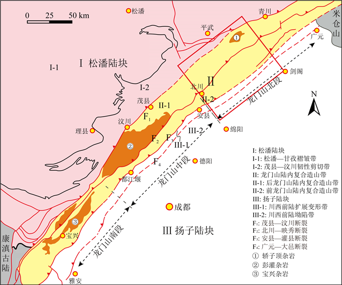
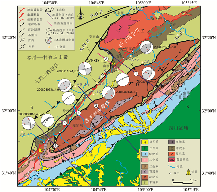
1 地质背景龙门山构造带是青藏高原(海拔~5000 m)和四川盆地之间(~500 m)的转换带,NE—SW向延伸,南起天全,北至广元,长~500 km,宽30~50 km(图 1).龙门山构造带西部是松潘—甘孜复理石(如Jia et al., 2006; Sengör and Hsü, 1984; Xu et al., 1992),主要由发生褶皱变形的三叠系组成;东侧是四川盆地,充填了一厚套中生代碎屑沉积,其中三叠系-白垩系被第三系覆盖,但是第三系的分布范围非常有限(如Burchfiel et al., 1995).龙门山构造带的海拔非常高(>4000 m),由3条倾向NW的主逆冲断裂组成,从NW到SE依次是汶川—茂县断裂、映秀—北川断裂和灌县—安县断裂,这些主断裂错断了元古代基底以及中生代和新生代盖层(图 2).汶川—茂县断裂(有的称之为茂汶断裂)错断了西边的三叠纪沉积岩和东边的元古代彭灌杂岩基底.有学者认为它是一条具有部分正滑性质的负向断裂(Xu et al., 2008),也有学者认为它是一条第三纪反转断裂(如Chen and Wilson, 1996; Zhou et al., 2007).汶川—茂县断裂、映秀—北川断裂和灌县—安县断裂都是逆冲断裂,其中映秀—北川断裂和灌县—安县断裂在汶川地震中被激活.这些断裂都错断了飞来峰底界拆离断裂(如Burchfiel et al., 1995; Chen and Wilson, 1996; Parsons et al., 2008; Royden et al., 2008).

|
图 1 龙门山构造带地质图(刘树根等, 2009, 图中红色框为研究区范围) Fig. 1 Geological map of Longmen Shan tectonic belt (Liu et al., 2009, the red wireframe in the figure is the range of the study area) |

|
图 2 龙门山构造带北段地质简图(据Wu et al., 2014修改) Y-B.F.—映秀—北川断裂;G-A.F.—灌县—安县断裂;P-Q.F.—平武—青川断裂;AJS.F.—安家山断裂;GZ.F.—关庄断裂;MJB.F.—马角坝断裂(灌县—安县断裂的北段);ZJB.F.—赵家坝断裂;测线序号分别是:1—南坝长剖面;2—南坝剖面;3—平通剖面;4—徐坪坝剖面;5—陈家坝剖面;6—北川剖面. Fig. 2 Geological map of the northern section of the Longmen Shan tectonic belt(modified from Wu et al., 2014) Y-B.F.—Yingxiu-Beichuan fault; G-A.F.—Guanxian-Anxian fault; P-Q.F.—Pingwu-Qingchuan fault; AJS.F.—Anjiashan fault; GZ.F.—Guanzhuang fault; MJB.F.—Majiaoba fault (the northern section of the Guanxian-Anxian fault); ZJB.F.—Zhaojiaba fault; The sequence number: 1—South dam section; 2—South dam section; 3—Pingtong section; 4—Xupingba section; 5—Chenjiaba section; 6—Beichuan section |
汶川地震之后,在汶川地震断裂带科学钻探项目及地质调查项目的支撑下,分别在不同段采集了数条与映秀—北川断裂近垂直的反射地震剖面(测线2, 4, 5)(图 2),剖面长9~19 km,采用道间距10 m,排列长度5000~6000 m,覆盖次数90~120次,双程反射时间5~6 s.汶川科钻4号孔(WFSD-4)刚好位于南坝测线上,钻遇到的地层为寒武系,平均速度4500~4600 m·s-1,利用VSP(Vertical Seismic Profiling,垂直地震剖面)资料进行了地震剖面的时深转换.
另外2条与映秀—北川断裂带近垂直的地震剖面——平通、南坝剖面(图 2中蓝色测线1, 3, 6),是由石油公司在2008年汶川地震前采集的,所采用的道间距15~20 m,排列长度4000~5000 m,覆盖次数60~72次,双程反射时间5~6 s,相当于~10—12 km深.在反射剖面上,如果构造和地层的倾角太大(>60°),则不能通过相应的反射轴反映出来,但是可以通过地震频率剖面、能量结构处理及地震反射轴的错断、错位、突变和异常波如散射波和断面反射波等来判断.
龙门山构造带自形成以来,在印支运动、燕山运动和喜山运动的改造作用下,地层的变形变质及构造极其复杂(如Chen et al., 1994; Chen and Wilson, 1996; Burchfiel et al., 1995; 刘树根等, 2009).此外,龙门山构造带地形起伏非常大,在~100 km范围内地形起伏~4000 m,是世界上地形起伏最大的高原边界(李勇等, 2006).地震资料的采集质量受地形、信噪比、岩性等多方面因素的影响,而地震资料的质量在很大程度上制约着地震资料的解译.为此,我们在汶川地震后反射地震采集的过程中,考虑了地表地质条件和深部构造的变化,采取了深井(激发炸药井深平均超过20 m)、长排列(5000~6000 m)、小道距(10 m)和高覆盖次数(90~120)等手段,用以提高反射地震的采集质量.同时,在地震资料处理过程中,我们应用了深部地震资料处理的技术(于常青等,2011;于常青等,2012;徐伯勋等,2001),通过精细去噪技术、密点速度分析、陡倾角偏移技术及瞬时频率和能量结构处理等手段对地震资料进行处理,获得了较为理想的反射地震成果.受诸多因素的影响,过龙门山构造带的钻井及测井资料等也极其稀少,因此,解释起来比较困难.但是可以借助地表地质资料、汶川地震断裂带科学钻探资料、有限的测井资料以及大型余震(M≥4.8)的震源机制解等资料进行解译.从1:50000地质图上可以看出,泥盆系是一个飞来峰,本文称之为唐王寨上推覆体(UTN),它与其下的志留系呈构造接触,拆离面为N1,志留系的底界在北川东南部有露头,其他地方则没有露头.北川东南部,志留系覆盖在泥盆系和三叠系上.因此,它是另一个飞来峰——唐王寨下推覆体,拆离面定为N2.这两个推覆体的西侧都被映秀—北川断裂错断,东侧被马角坝断裂错断.映秀—北川断裂西边的剪切变形带,环绕在轿子顶基底杂岩周围,分割了志留系和寒武系,与赵家坝断裂相接.据此可以认为这个剪切变形带是唐王寨下推覆体的底界N2,轿子顶前寒武系杂岩是基底的构造高点,这使它看起来像是一个穿过推覆体的构造窗.与测线1近垂直的一个地震剖面(Li et al., 2010中的剖面7)显示石坎东北部的挤出程度比南西部高,这与我们的解释一致.唐王寨上推覆体的底界出露在唐王寨下推覆体的西边.安家山断裂和赵家坝断裂相连(图 2),这意味着唐王寨推覆体来源于九顶山推覆体,彭灌杂岩亦如此.但是唐王寨推覆体的形成时间并不确定,可能是印支期,也可能是喜马拉雅期,不管是什么时候形成,一定早于映秀—北川断裂形成时间.因此,可以用推覆体的错断位移来估测映秀—北川断裂的错断位移.
根据发震断裂的地表形态以及震源机制解,李海兵等(2008a, 2008b)勾绘出了映秀—北川断裂的地表破裂带.他们在野外测量了几个点位主断面的走向、倾角以及同震垂直位移和水平位移,有了这些参数就可以根据以下公式计算出断裂的运动方向:Pi=arctg(Ov/(Oh×sinD)),其中,Ov是垂直位移,Oh是水平位移,D是断面倾角,Pi是断面上测量的侧伏角.当侧伏角为0°,则是水平运动,当侧伏角为90°,则是倾向运动.
汶川地震后发生了大量余震,这些余震的分布在一定程度上反映了映秀—北川断裂的展布(Rubin et al., 1999a, 1999b; Scholz, 1990).从余震的平面分布图上可以看出,南坝西南部的大部分余震震中都在活动断裂的NW盘,这说明南坝西南部断裂以逆冲运动为主,上盘活动强度大,因而余震大都集中在断裂北西侧,而走滑断裂两盘都在活动,活动强度相当,所以走滑断裂的余震在两侧都有分布(Chang et al., 2000; 吴建平等, 2009).余震的重新定位结果表明映秀—北川断裂北东段非常陡,以走滑为主,但是这些并不能精确确定断裂深部的几何形态.因此,本文结合地表地质资料、汶川地震断裂带科学钻探资料、有限的测井资料以及大型余震(M≥4.8)的震源机制解对映秀—北川断裂深部的几何形态进行约束,并在此基础上结合地表滑移分布主要探讨了它对地表破裂的控制.
3 龙门山构造带反射地震构造分析根据地表破裂带的几何学和运动学特征,将映秀—北川破裂带分为南北两段,其中,南段破裂带从映秀镇延伸到绵竹市清平镇,长约100 km,破裂带性质以逆冲为主兼右旋走滑分量,垂直位移高达~6.5 m,水平位移2~5 m;北段破裂带从清平镇过北川县、平武县平通镇、南坝镇到青川县木鱼乡西,长约175 km,破裂性质以右旋走滑为主兼逆冲分量,垂直位移高达11~12 m,水平位移高达~12 m(李海兵等, 2008a, 2008b, 2009, 2010).
3.1 南坝剖面构造特征(图 2中1号剖面)在南坝镇东北部2 km的磨湾村,地表破裂在磨湾一带的谷地中穿过,走向~N44°.野外测量测得断裂产状为走向42°~44°,倾向NW,倾角71°.地表破裂作用使横穿的道路发生拱曲,测得水平位移2.5 m,垂直位移2 m.田埂被水平错断1.3~1.6 m,垂直位移1~1.2 m(李传友等, 2008).麦田被右旋水平错断1.3 m,垂直错断~1.0 m(李传友等, 2008; Li et al., 2010).这些测量数据表明断裂为右旋逆冲运动,根据断裂倾角71°,以及测得的水平位移和垂直位移,估算出同震断裂擦痕向SE方向侧伏32°~40°.
2个余震的震源机制解也表明该断裂在12~16 km深处的运动方向是斜向运动(AS-3和AS-5,图 2).由于映秀—北川断裂倾向NW,所以震源机制解揭示的倾向NW的断裂最有可能是映秀—北川断裂(图 2).这些断裂面与走向N66°,倾向NW,倾角49°,侧伏66°SE(AS-3)的断面和走向N69°,倾向NW,倾角48°,侧伏54°SE(AS-5)的断面一致,它们具有相似的水平位移分量,而且深处的水平位移比地表位移小(地震剖面1中,视倾角44°,图 2).
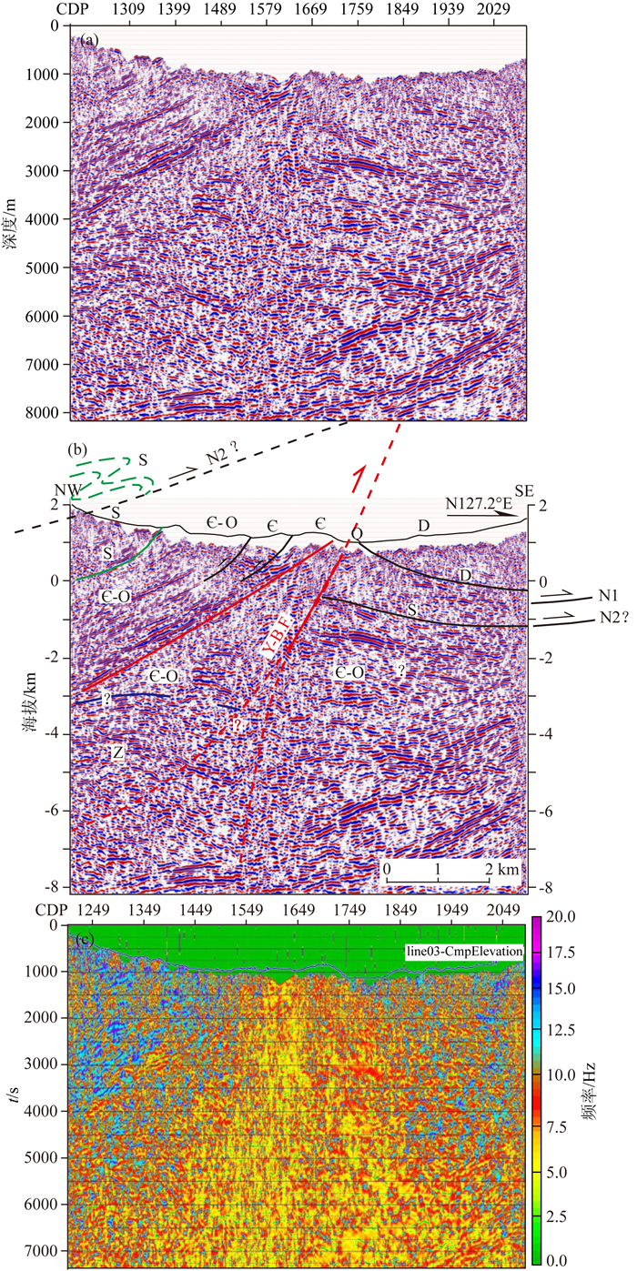
地震剖面1方位为N126.5°E,始于志留系千枚岩、结晶灰岩和石英砂岩,往南东方向依次经过寒武系硅质岩、唐王寨推覆体(由志留系和泥盆系组成)、三叠系沉积岩,终止于侏罗系,长45.5 km(图 3).在南东部,马角坝断裂和江油断裂切割了四川盆地西部边界,马角坝断裂向上分成两支,这两条断裂在近地表非常陡,可能向西延伸至深部尖灭或者延伸至深部滑脱面上.马角坝断裂西侧的唐王寨推覆体具有明显的叠覆式特征,它由2层推覆体组成,上层推覆体由泥盆系组成,这里称之为唐王寨上推覆体(UTN),底部断裂面名之为N1;下层由志留系组成,称之为唐王寨下推覆体(LTN),底部断裂面名之为N2,它们的拆离面受后期变形作用的影响,都发生了褶曲,上推覆体被一个小型正断裂错断,但是,这条正断裂没有错断下部推覆体的地层.这个很宽的推覆体构造相对较平缓,它的西部被映秀—北川断裂错断,估测其垂直位移量-3 km.再往西,组成唐王寨下推覆体的志留系在寒武系西侧有露头,因此,应该是西北部-15 km远的赵家坝断裂将它推覆到下伏石炭系-二叠系之上.根据反射特征,推覆体下伏地层中发育一相对较缓的断裂,错断了石炭系-二叠系,但没错断推覆体,这条断裂与东边马角坝断裂在~7 km相连,马角坝断裂将泥盆系推至三叠系之上(图 3).再往东,在三叠系之上坐落着NE—SW向延伸,由寒武系、泥盆系-二叠系组成的小型推覆体(图 3),地震剖面在推覆体南西端的二叠系中经过,继续往东,江油断裂错断了三叠系,根据地质图,上盘的侏罗系已被剥蚀,下盘侏罗系不整合覆盖在三叠系之上(图 3).

|
图 3 南坝地震剖面 (a)地震剖面; (b)构造解译图; (c)地震瞬时频率剖面,剖面位置见图 2. (b)剖面中红线为映秀—北川断裂;黑线为断裂,黑色虚线为推测的断裂;绿色虚线方框为与剖面2近平行的剖面(图 3);彩色线为以下地层的分界线:Z—震旦系;C-—寒武系;S—志留系;D—泥盆系;P —二叠系;T—三叠系;J—侏罗系. UTN—上唐王寨推覆体;LTN—下唐王寨推覆体;N1—上唐王寨推覆体底界拆离断裂;N2—下唐王寨推覆体底界拆离断裂;AS-3和AS-5为投影到剖面上的余震震源机制解.(c)剖面中,红、黄色为较低频率,蓝色和粉色为较高频率. Fig. 3 Nanba seismic profile (a) is the seismic profile, (b) is the tectonic interpretation map, (c) is the instantaneous frequency profile, and the profile position is shown in Fig. 2. In profile (b), the red line is the Yingxiu-Beichuan fractures; the black lines are faults and the black dashed line is a speculating fracture; the green dashed line wireframe is a profile nearly parallel to profile 2 (Fig. 3); the color line is the dividing lines of the following strata: Z—Sinian; C-—Cambrian; S—Siluric; D—Devonian; P—Permian; T—Triassic; J—Jurassic. UTN—upper Tangwangzhai nappe; LTN—lower Tangwangzhai nappe; N1—detachment fracture in the bottom of upper Tangwangzhai nappe; N2—detachment fracture in the bottom of lower Tangwangzhai nappe; AS-3 and AS-5 are the focal mechanism solution of the aftershock from the projection to the section. In profile (c), the red and yellow is low frequency, the blue and pink is high frequency. |
在频率剖面上(图 3),映秀—北川断裂带与整体剖面对比显示明显的频率低(15~26 Hz),呈现一个明显的低频带.而唐王寨推覆体则显示为高频(27~42 Hz)特征,这与构造解释相一致,为提高对断裂带性质和深部结构分析提供了依据.
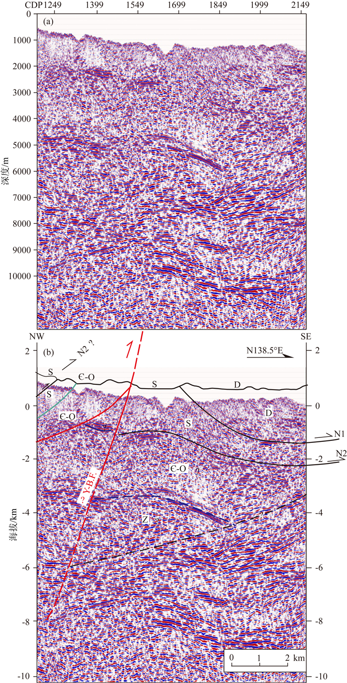
剖面2与剖面1近平行(图 2),是汶川地震后新采集的地震剖面.测线方位N130.8°E,始于志留系,垂直穿过映秀—北川地表破裂带,终止于唐王寨推覆体中的志留系,长18.9 km,它与剖面1相距~2.7 km(图 2).这条剖面是于2009年采集的,道间距10 m,记录了~10 km深的地质信息,由于采取了针对性的采集和处理方法,所得到的剖面与剖面1相比,结构特征清晰,可以较精确地揭示映秀—北川断裂的形态(图 4).剖面的反射特征显示映秀—北川断裂非常陡(倾角-70°),这与地表测量结果一致.到-7 km深,断裂倾角-55°,这与附近的震源机制解一致.映秀—北川断裂的位移量相对较小,因为它只错断了寒武系层位,但是,关庄断裂,映秀—北川断裂的一个分支,位移量较大,上盘的寒武系逆冲到唐王寨下部推覆体的志留系之上.这两条断裂在深处合并.关庄断裂走向N50°,倾向NW,倾角70°,它是映秀—北川断裂的一个主要的分支断裂.根据唐王寨下部推覆体的位移估测总垂直位移量达6 km(图 4).

|
图 4 南坝地震剖面(2号剖面) (a)地震剖面; (b)地质解译图; (c)能量结构剖面,剖面位置见图 2. WFSD-4—汶川科钻4号孔;O—奥陶系;其他说明同图 3. Fig. 4 Nanba seismic profile (Section 2) (a) The seismic profile; (b) The geological interpretation map; (c) The energy structure profile, and the profile position is shown in Fig. 2. WFSD-4—No.4 hole in Wenchuan Scientific Drilling, O—Ordovician, the other instructions are the same as Fig. 3. |
从图 4的能量结构叠合图上来看,剖面在3000 ms(约5 km深度)明显分为上下两级构造,上部分构造复杂,角度陡,断裂变化大,下部构造相对平缓,能量差异相对较小.剖面上断裂处能量差异明显,显示了该地区经历了多期次的构造运动.
3.2 平通剖面构造特征(图 2中3号剖面)在平通,地表破裂带穿过平通镇,错断了平通河的漫滩与河床,一走向N55°的褶皱陡坎穿过河漫滩,断裂NW盘隆升3.6~4.2 m(李传友等,2008).玉米地的南西边被右旋水平错断~3.9 m,垂直错断3.6 m.横跨断裂陡坎的探槽显示,断裂走向N55°,倾向NW,倾角71°.根据水平位移和垂直位移估算出断裂擦痕侧伏44°SW.
过平通镇的地震反射剖面3方位角N138.7°E,穿过映秀—北川断裂、唐王寨推覆体和四川盆地西部边界,长约45.3 km(图 5).盆地内沉积岩的反射特征很清晰,反射同相轴连续性好,地震反射特征显示,下伏二叠系-三叠系与上覆侏罗系呈明显的角度不整合面接触,表明晚三叠世-侏罗纪之间该区发生过一次挤压隆升的构造运动.地震剖面解译结果显示,侏罗系之下有5条叠瓦状逆冲断裂延伸到四川盆地的沉积层中,四川盆地的西部边界断裂——马角坝断裂呈‘断坡-断坪-断坡’式,界定了上盘的三叠系和下盘的三叠系-侏罗系,使其呈断裂接触(图 5).再往西,则是由两层推覆体组成的唐王寨推覆体,唐王寨上、下推覆体分别由泥盆系和志留系组成,其下仍有一条倾角约65°的断裂延伸到马角坝断裂的断坡上,推覆体西侧的映秀—北川断裂,产状仍然很陡,倾角~70°-75°,它错断了唐王寨推覆体,估测其垂直位移~3 km.

|
图 5 平通地震剖面 (a)地震剖面; (b)地质解译图; (c)能量结构剖面; (d)瞬时频率剖面,剖面位置见图 2,图中说明同图 3. Fig. 5 Pingtong seismic profile (a) The seismic profile; (b) The geological interpretation map; (c) The energy structure profile; (d) The instantaneous frequency profile, the profile position is shown in Fig. 2, the instructions are the same as Fig. 3. |
从能量结构剖面和频率剖面(图 5)可以看出,唐王寨推覆体与下覆地层之间呈明显的能量差异和高频(28~40 Hz)的特征,映秀—北川断裂带表现为能量连续性差、差异性大及频率低(15~27 Hz)的特征,这与图 4b的特征基本一致.
3.3 徐坪坝剖面构造特征(图 2中4号剖面)在徐坪坝镇东南2.4 km的桂溪乡西边,地表破裂向~N25°—30°延伸,倾向NW.一条废弃河道被右旋水平错断1.4±0.2 m,垂直错断1.65 m,冲积阶地被右旋水平错断1.6 m,垂直错断2.0±0.1 m(李传友等, 2008; Li et al., 2010).
2009年在徐坪坝镇西侧志留系,沿N138.5°E方向,横跨映秀—北川断裂,终止于唐王寨推覆体向斜NW翼的泥盆系,采集了一条道间距10 m的人工地震反射剖面(图 2),经过地震资料处理,清晰地揭示了~9.8 km长,~10 km深的结构构造(图 6).从图中可以看出,映秀—北川断裂东侧,是唐王寨推覆体.地表破裂带位于寒武系和志留系的交界(图 2),断裂很陡(倾角~70°).在映秀—北川断裂北侧有一条相对较缓的断裂,这条断裂是唐王寨下推覆体的滑脱面,映秀—北川断裂将其错断,据此估测唐王寨下推覆体被垂直错断4~5 km.根据地震剖面展示的断裂倾角以及地表破裂位移,估算出断裂侧伏50°~55°SW.

|
图 6 徐坪坝地震剖面 (a)地震剖面; (b)地质解译图,剖面位置见图 2,图中说明同图 3. Fig. 6 Xupingba seismic profile (a) The seismic profile; (b) The geological interpretation map, and the profile position is shown in Fig. 2, the instructions are the same as Fig. 3. |
陈家坝剖面是汶川地震后新采集的地震剖面,剖面自北西向南东穿过映秀—北川断裂带,终止于唐王寨推覆体向斜NW翼的泥盆系,长约9 km(图 2).它所展示出来的构造与剖面4相似,唯一不同的是,从地表破裂带往深部延伸,有3条断裂而不是2条(图 7).反射轴产状不同所界定的断裂是一条缓倾角断裂,倾角约35°~40°,而另一条断裂产状很陡,~5 km以上倾角~75°(图 7).如果唐王寨推覆体是从西侧推覆过来,后期映秀—北川断裂将其错断,那么,据此推测,唐王寨下推覆体被垂直错断4~5 km.5 km以下的影像特征不明显,因此在深部是陡是缓不太清楚.

|
图 7 陈家坝地震剖面 (a)地震剖面; (b)地质解译图; (c)瞬时频率剖面,剖面位置见图 2,图中说明同图 3. Fig. 7 Chenjiaba seismic profile (a) The seismic profile; (b) The geological interpretation map; (c) The instantaneous frequency profile, and the profile position is shown in Fig. 2, the instructions are the same as Fig. 3. |
该区同震地表破裂穿过黄家坝的冲积扇和河流,洪积扇被右旋水平错断1.8±0.3 m,垂直错断1.95±0.2 m.废弃河道被右旋水平错断2.0±0.3 m,垂直错断2.54 m(李传友等, 2008; Li et al., 2010).
根据地震剖面显示的断裂倾角(75°)以及地表破裂位移,计算出断裂运动轨迹侧伏41°~57°SW.
从图 7可见,在地震频率剖面中部,由于映秀—北川断裂正处于剖面中部,整体剖面为断裂破碎带,所以地震频率整体显示比较低(3~20 Hz),而断裂带位置频率明显更低(5~11 Hz),且由于断裂期次的不同造成频率降低的程度亦有变化,在剖面中间部分形成一个明显的断裂破碎带(低频带),这些特征为判断断裂性质和构造变化提供了依据.
4 讨论 4.1 映秀—北川断裂北段的几何形态虽然有学者已经对龙门山构造带北段的构造进行过研究(Jia et al., 2010; Li et al., 2010; 王毛毛等, 2010),他们提出,映秀—北川断裂北东段倾角不大于50°,到地下10 km变得非常缓(< 20°),而且向下延伸至~7—10 km而不是~15—17 km的滑脱面上.如果映秀—北川断裂北段平缓,则很难解释余震分布范围比较狭窄以及沿断裂两侧分布的特征,因为通常情况下,走滑断裂两盘在运动过程中往往造成两侧介质的破坏程度相当,在震后应力调整过程中余震会沿着断裂两侧发生在相对狭窄的带中(Chang et al., 2000; 吴建平等, 2009).此外,北段断裂平缓的几何形态与余震重新定位、震源机制解、远震波形数据反演结果以及GPS反演结果(Yu et al., 2010; 吴建平等, 2009; Huang et al., 2008; Nakamura et al., 2010; Wang et al., 2011)不一致.
本次研究表明映秀—北川断裂北东段断裂较陡,10 km以上断裂倾角~50°—70°,向下延伸到~20 km的滑脱面上.Hubbard和Shaw(2009)以及Hubbard等(2010)通过对地震剖面的解译,指出从拆离面往上到~13 km以上映秀—北川断裂分为两支,北边的一支倾角~58°,而南边分支倾角~44°.Zhang等(2010)提出发震断裂是高角度铲式断裂,断裂在~15 km以上倾角~70°,~15 km以下30°~40°,并向下延伸到20~22 km的脆韧转换带上.Guo等(2013)通过对新采集的跨越若尔盖盆地和龙门山构造带中段北端的深地震反射剖面的分析,也揭示了映秀—北川断裂高角度的几何形态.余震重新定位、震源机制解、远震波形数据反演以及GPS反演等也揭示了发震断裂高角度的几何形态(Yu et al., 2010; 吴建平等, 2009; Huang et al., 2008; Nakamura et al., 2010; Wang et al., 2011).
映秀—北川断裂的断裂迹线是线型的,这意味着它的产状很陡.在东北段,地表破裂带的倾角大于60°,有可能是曲率很大的铲式断裂.但是,6~12 km的大型余震的震源机制解显示断裂面倾向NW,倾角大于45°.这意味着,在深处,活动断裂并没有变得很平缓.地震剖面解译结果表明映秀—北川断裂的产状很陡(据Wu et al., 2014).
4.2 龙门山北段深部构造对地表破裂的控制汶川地震及其余震分布在~10—15 km,从震源~10—15 km深处破裂到地表,必然经过了深部各种复杂的沉积地层及地质构造,它们也必然在一定程度上制约着地震能量的传播和地表破裂过程.
汶川地震后,大量研究学者通过地震波的反演、GPS和InSAR反演等对汶川地震的破裂过程进行了研究(张勇等, 2009; 王卫民等, 2008; 赵翠萍等, 2009; 杜义等, 2009; Zhang et al., 2009; Nakamura et al., 2010; Shen et al., 2009; Tong et al., 2010; Feng et al., 2010; Wang et al., 2011),提出了不同的破裂模式.单一铲式破裂模型模拟的结果表明,自起始点向东北方向单侧扩展,前40 s内形成映秀破裂带和灌县—安县破裂带,之后沿北川断裂继续向东北方向扩展,形成~240—270 m长的映秀—北川地表破裂带(Zhang et al., 2009; 赵翠萍等, 2009).王为民等(2008)则认为滑动过程在两个大的滑移区的滑移方向自深部到浅表都是逆冲-斜冲-水平运动.而赵翠萍等(2009)认为破裂带南段15 km以下以逆冲-右旋走滑为主,15 km以上以纯逆冲错动为主;而北段10 km以上以右旋走滑为主,没有垂直分量.用GPS和InSAR数据反演给出的滑移模型揭示位移量峰值处存在4个异常体,阻止或促使了破裂过程的传播及发展,导致破裂过程的复杂性,在地表表现为同震断裂擦痕以及滑移量和滑移分布的复杂性(Wang et al., 2011; Tong et al., 2010; Feng et al., 2010; Shen et al., 2009).黏弹性有限元方法模拟得出的汶川地震破裂过程揭示出同震滑动起初是在发震断裂的缓倾角段开始的,同震破裂在缓倾角和陡倾角断裂上同时发生,滑移量的增加降低了断裂面上的正应力,降低了断裂摩擦强度,从而增加了断裂面上的剪应力,这样一来,就促使了断裂在足够的构造应力推动下向更远处滑动(Zhu and Zhang, 2013).
断裂几何形态的复杂性导致了震前孕震过程中应力积累的变化,从而影响了断裂之间相互作用的动力机制,进一步影响破裂过程.次级破裂的产生会消耗掉一部分能量,从而在一定程度上约束了破裂的扩展过程.此外,非断裂面上的非脆性变形也会吸收位移量,但是非脆性变形在野外很难识别.这些因素都影响了地震的破裂过程以及地表破裂带位移量的变化.
前已所述,地震资料解译结果显示,映秀—北川断裂北段在~7—8 km以上产状较陡,倾角大于45°地震频率剖面上显示低频特征明显(15~26 Hz),往深部延伸到~20 km的滑脱面上.北段从北川到南坝,在~10 km以上,断裂倾角~50°—70°.汶川地震中龙门山构造带处于挤压环境(如Parson et al., 2008; Toda et al., 2008; Luo and Liu, 2010; 崔军文等, 2013; Cui et al., 2014),根据脆性破裂准则,高角度断裂在垂直于挤压方向上是不容易发生破裂的,容易发生走滑运动,形成窄而陡的断裂带.地表地质调查结果表明,映秀—北川断裂北段以走滑为主,走滑分量大于垂向逆冲分量,破裂带宽度也只有~10 m(李海兵等, 2008a).显然,深部高角度的几何形态约束了断裂运动趋向于以走滑运动为主,到浅表受多方面因素的变化(如温度、压力等),导致运动方向发生一定的偏移,造成了走滑运动中的逆冲分量,这与地震波反演、GPS和InSAR反演等得出的滑移方向沿深度和走向发生变化的结果一致(张勇等, 2009; 王卫民等, 2008; 赵翠萍等, 2009; 杜义等, 2009; Zhang et al., 2009; Nakamura et al., 2010; Shen et al., 2009; Tong et al., 2010; Feng et al., 2010; Wang et al., 2011).余震震源机制解揭示,断裂往北逐渐变陡,从而吸纳了北段的走滑分量,断裂高角度的几何形态在一定程度上影响了余震沿断裂走向的变化(Yu et al., 2010).由此可见,断裂的几何形态在一定程度上约束了断裂带的结构构造和运动特性(据Wu et al., 2014),影响地震破裂过程,进一步影响了滑移量的发育和分布.
5 结论(1) 映秀—北川断裂北段是一条倾向NW的高角度走滑断裂,兼逆冲分量,10 km以上断裂倾角~50°—70°,向下延伸到~20 km的滑脱面上,在反射地震剖面上显示明显的能量连续性差、频率低、振幅杂乱的特征.而且,从震前和震后的反射特征剖面对比分析来看,汶川地震后剖面上显示的断裂附近频率特性明显低于震前剖面,能量特征两者相近但是连续性明显变差.它错断了唐王寨推覆体(在地震剖面上显示为高频特征,在能量结构剖面上显示该推覆体与周边地层能量差异大),发生在寒武-志留纪柔性地层之间以及志留纪和前寒武纪(刚/柔性)之间;位移量至少~3 km;唐王寨推覆体之下存在一条隐伏逆冲断裂.
(2) 映秀—北川断裂高角度的几何形态约束了断裂以走滑运动为主兼逆冲分量的运动性质,使走滑过程中断裂两盘的相对运动诱发的余震沿断裂两盘分布,而且分布在一个相对狭窄的带上.此外,映秀—北川断裂往北逐渐变陡(如前述的构造解释及地震频率剖面和能量结构剖面特征所显示),吸纳了地表滑移量,阻碍了地表破裂的继续扩展.
致谢感谢中国地质科学院地质研究所李海兵研究员、中国地震局地球物理研究所李丽研究员、中国石油集团东方地球物理公司王琪处长以及研究生周宇、罗愫、谈顺佳等人在本文研究过程中的帮助和支持.特别感谢南京大学吴婵博士提供了地震资料解释分析.感谢审稿专家对本文提出的宝贵修改意见和建议.
An Y F, Han Z J, Dong S P, et al.
2010. Features and tectonic implications of Wenchuan MS8.0 earthquake on the central fault of Longmen Shan fault zone. Seismology and Geology (in Chinese), 32: 1-15.
|
|
Arne D, Worley B, Wilson C, et al.
1997. Differential exhumation in response to episodic thrusting along the eastern margin of the Tibetan Plateau. Tectonophysics, 280(3): 239-256.
|
|
Avouac J P, Tapponnier P.
1993. Kinematic model of active deformation in central Asia. Geophysical Research Letters, 20(10): 895-898.
DOI:10.1029/93GL00128 |
|
Burchfiel B C, Royden L H, van der Hilst R D, et al.
2008. A geological and geophysical context for the Wenchuan earthquake of 12 May 2008, Sichuan, People's Republic of China. GSA Today, 18(7): 4-11.
DOI:10.1130/GSATG18A.1 |
|
Burchfiel B C, Chen Z, Liu Y, et al.
1995. Tectonics of the Longmen Shan and adjacent regions, central China. International Geology Review, 37(8): 661-735.
DOI:10.1080/00206819509465424 |
|
Chang C H, Wu Y M, Shin T C, et al.
2000. Relocation of the 1999 Chi-Chi earthquake in Taiwan. Terrestrial Atmospheric and Oceanic Sciences, 11(3): 581-590.
DOI:10.3319/TAO.2000.11.3.581(CCE) |
|
Chen S F, Wilson C J L, Deng Q D, et al.
1994. Active faulting and block movement associated with large earthquakes in the Min Shan and Longmen Mountains, northeastern Tibetan Plateau. Journal of Geophysical Research: Solid Earth, 99(B12): 24025-24038.
DOI:10.1029/94JB02132 |
|
Chen S F, Wilson C J L.
1996. Emplacement of the Longmen Shan thrust-nappe belt along the eastern margin of the Tibetan plateau. Journal of Structural Geology, 18(4): 413-430.
|
|
Chen Z H, Burchfiel B C, Liu Y, et al.
2000. Global Positioning System measurements from eastern Tibet and their implications for India/Eurasia intercontinental deformation. Journal of Geophysical Research: Solid Earth, 105(B7): 16215-16227.
DOI:10.1029/2000JB900092 |
|
Cui J W, Li Z F, Wang L J, et al.
2013. Determination of three-dimensional in situ stresses from anelastic strain recovery (ASR) of Wenchuan Earthquake Fault Scientific Drilling Project Hole-1 (WFSD-1) and formation mechanism of the "5·12" Wenchuan earthquake. Acta Petrologica Sinica (in Chinese), 29(6): 2033-2047.
|
|
Cui J, Lin W, Wang L, et al.
2014. Determination of three-dimensional in situ stresses from anelastic strain recovery (ASR) of Wenchuan Earthquake Fault Scientific Drilling Project Hole-1 (WFSD-1). Tectonophysics, 619-620: 123-132.
DOI:10.1016/j.tecto.2013.09.013 |
|
De Michele M, Raucoules D, De Sigoyer J, et al.
2010. Three-dimensional surface displacement of the 2008 May 12 Sichuan earthquake (China) derived from Synthetic Aperture Radar: evidence for rupture on a blind thrust. Geophysical Journal International, 183(3): 1097-1103.
DOI:10.1111/j.1365-246X.2010.04807.x |
|
Densmore A L, Ellis M A, Li Y, et al.
2007. Active tectonics of the Beichuan and Pengguan faults at the eastern margin of the Tibetan Plateau. Tectonics, 26(4): 1-17.
|
|
Du Y, Xie F R, Zhang X L, et al.
2009. The mechanics of fault slip of MS8.0 Wenchuan earthquake. Chinese Journal of Geophysics (in Chinese), 52(2): 464-473.
|
|
Feng G C, Hetland E A, Ding X L, et al.
2010. Coseismic fault slip of the 2008 MW7.9 Wenchuan earthquake estimated from InSAR and GPS measurements. Geophysical Research Letters, 37(1): 1-5.
|
|
Feng S Y, Zhang P Z, Liu B J, et al.
2016. Deep crustal deformation of the Longmen Shan, eastern margin of the Tibetan Plateau, from seismic reflection and Finite Element modeling. Journal of Geophysical Research: Solid Earth, 121: 767-787.
|
|
Fu B H, Shi P L, Zhang Z W.
2008. Spatial characteristics of the surface rupture produced by the MS8.0 Wenchuan earthquake using high-resolution remote sensing imagery. Acta Geologica Sinica (in Chinese), 82(12): 1679-1687.
|
|
Fu B, Shi P, Guo H, et al.
2011. Surface deformation related to the 2008 Wenchuan earthquake, and mountain building of the Longmen Shan, eastern Tibetan Plateau. Journal of Asian Earth Sciences, 40(4): 805-824.
DOI:10.1016/j.jseaes.2010.11.011 |
|
Godard V, Pik R, Lavé J, et al.
2009. Late Cenozoic evolution of the central Longmen Shan (Eastern Tibet), insight from (U-Th)/He thermochronometry. Tectonics, 28(5): 1-17.
DOI:10.1029/2008TC002407 |
|
Guo X, Gao R, Keller G R, et al.
2013. Imaging the crustal structure beneath the eastern Tibetan Plateau and implications for the uplift of the Longmen Shan range. Earth and Planetary Science Letters, 379: 72-80.
DOI:10.1016/j.epsl.2013.08.005 |
|
Huang Y, Wu J P, Zhang T Z, et al.
2008. Relocation of the M8.0 Wenchuan earthquake and its aftershock sequence. Science in China (Series D), 51(12): 1703-1711.
DOI:10.1007/s11430-008-0135-z |
|
Hubbard J, Shaw J H, Klinger Y.
2010. Structural setting of the 2008 MW7.9 Wenchuan, China, earthquake. Bulletin of the Seismological Society of America, 100(5B): 2713-2735.
DOI:10.1785/0120090341 |
|
Hubbard J, Shaw J H.
2009. Uplift of the Longmen Shan and Tibetan plateau, and the 2008 Wenchuan (MS7.9) earthquake. Nature, 458(7235): 194-197.
DOI:10.1038/nature07837 |
|
Jia D, Li Y, Lin A, et al.
2010. Structural model of 2008 MW7.9 Wenchuan earthquake in the rejuvenated Longmen Shan thrust belt, China. Tectonophysics, 491(1): 174-184.
|
|
Jia D, Wei G, Chen Z, et al.
2006. Longmen Shan fold-thrust belt and its relation to western Sichuan Basin in central China: New insights from hydrocarbon exploration. AAPG Bulletin, 90(9): 1425-1447.
DOI:10.1306/03230605076 |
|
Li C Y, Wei Z Y, Ye J Q, et al.
2010. Amounts and styles of coseismic deformation along the northern segment of surface rupture, of the 2008 Wenchuan MW7.9 earthquake, China. Tectonophysics, 491(1): 35-58.
|
|
Li C Y, Ye J Q, Xie F R, et al.
2008. Characteristics of the surface rupture zone of the MS8.0 Wenchuan earthquake, China along the segment north to Beichuan. Seismology and Geology (in Chinese), 30(3): 683-696.
|
|
Li H B, Fu X F, van der Woerd J, et al.
2008a. Coseismic surface rupture and dextral-slip oblique thrusting of the MS8.0 Wenchuan earthquake. Acta Geologica Sinica (in Chinese), 82(12): 1623-1643.
|
|
Li H B, Si J L, Fu X F, et al.
2009. Co-seismic rupture and maximum displacement of the 2008 Wenchuan earthquake and its tectonic implications. Quaternary Sciences (in Chinese), 29(3): 387-402.
|
|
Li H B, Si J L, Pei J L, et al.
2010. Investigating the surface rupture process of the Wenchuan earthquake (MS8.0). Quaternary Sciences (in Chinese), 30(4): 677-698.
|
|
Li H B, Wang Z X, Fu X F, et al.
2008b. The surface rupture zone distribution of the Wenchuan earthquake (MS8.0) happened on May 12th, 2008. Geology in China (in Chinese), 35(5): 803-813.
|
|
Li Y, Jia D, Shaw J H, et al.
2010. Structural interpretation of the coseismic faults of the Wenchuan earthquake: Three-dimensional-modeling of the Longmen Shan fold-and-thrust belt. Journal of Geophysical Research, 115: B04317.
DOI:10.1029/2009JB006824 |
|
Li Y, Zhou R J, Densmore A L, et al.
2006. Geomorphic evidence for the Late Cenozoic strike-slipping and thrusting in Longmen Mountain at the eastern margin of the Tibetan Plateau. Quaternary Sciences (in Chinese), 26(1): 40-51.
|
|
Lin A, Ren Z, Jia D, et al.
2009. Co-seismic thrusting rupture and slip distribution produced by the 2008 MW7.9 Wenchuan earthquake, China. Tectonophysics, 471(3): 203-215.
|
|
Liu J, Zhang Z H, Wen L, et al.
2008. The MS8.0 Wenchuan earthquake coseismic rupture and its tectonic implications—An out-of-sequence thrusting event with slip partitioned on multiple faults. Acta Geologica Sinica (in Chinese), 82(12): 1707-1722.
|
|
Liu S, Li Z, Cao J, et al.
2009. 4-D textural and structural characteristics of Longmen intracontinental composite orogenic belt, southwest China. Chinese Journal of Geology (in Chinese), 44(4): 1151-1180.
|
|
Liu Z J, Sun J, Wang P, et al.
2012. Surface ruptures on the transverse Xiaoyudong fault: A significant segment boundary breached during the 2008 Wenchuan earthquake, China. Tectonophysics, 580: 218-241.
DOI:10.1016/j.tecto.2012.09.024 |
|
Luo G, Liu M.
2010. Stress evolution and fault interactions before and after the 2008 Great Wenchuan earthquake. Tectonophysics, 491(1): 127-140.
|
|
Meade B J.
2007. Present-day kinematics at the India-Asia collision zone. Geology, 35(1): 81-84.
DOI:10.1130/G22924A.1 |
|
Nakamura T, Tsuboi S, Kaneda Y, et al.
2010. Rupture process of the 2008 Wenchuan, China earthquake inferred from teleseismic waveform inversion and forward modeling of broadband seismic waves. Tectonophysics, 491(1): 72-84.
|
|
Parsons T, Ji C, Kirby E.
2008. Stress changes from the 2008 Wenchuan earthquake and increased hazard in the Sichuan basin. Nature, 454(7203): 509-510.
DOI:10.1038/nature07177 |
|
Royden L H, Burchfiel B C, van der Hilst R D.
2008. The geological evolution of the Tibetan Plateau. Science, 321(5892): 1054-1058.
DOI:10.1126/science.1155371 |
|
Rubin A M, Gillard D, Got J L.
1999a. Fault fabrics/earthquake mechanics from precise relative earthquake locations. Seismological Research Letters, 70: 246.
|
|
Rubin A M, Gillard D, Got J L.
1999b. Streaks of microearthquakes along creeping faults. Nature, 400(6745): 635-641.
DOI:10.1038/23196 |
|
Scholz C H. 1990.
The Mechanics of Earthquakes and Faulting. Cambridge, U. K.: Cambridge University Press.
|
|
Sengör A M C, Hsü K J.
1984. The cimmerides of eastern Asia: history of the eastern end of Paleo-Tethys. Mem. Soc. Geol. France, 147: 139-167.
|
|
Shen Z K, Lu J N, Wang M, et al.
2005. Contemporary crustal deformation around the southeast borderland of the Tibetan Plateau. Journal of Geophysical Research, 110(B11): 11409.
DOI:10.1029/2004JB003421 |
|
Shen Z K, Sun J, Zhang P, et al.
2009. Slip maxima at fault junctions and rupturing of barriers during the 2008 Wenchuan earthquake. Nature Geoscience, 2(10): 718-724.
DOI:10.1038/ngeo636 |
|
Stone R.
2008. An unpredictably violent fault. Science, 320: 1578-1580.
DOI:10.1126/science.320.5883.1578 |
|
Tapponnier P, Xu Z Q, Roger F, et al.
2001. Oblique stepwise rise and growth of the Tibet Plateau. Science, 294(5547): 1671-1677.
DOI:10.1126/science.105978 |
|
Toda S, Lin J, Meghraoui M, et al.
2008. 12 May 2008 M=7.9 Wenchuan, China, earthquake calculated to increase failure stress and seismicity rate on three major fault systems. Geophysical Research Letters, 35(17): 1-6.
|
|
Tong X, Sandwell D, Fialko Y.
2010. Coseismic slip model of the 2008 Wenchuan earthquake derived from joint inversion of interferometric synthetic aperture radar, GPS, and field data. Journal of Geophysical Research, 115(B04314): 1-19.
DOI:10.1029/2009JB006625 |
|
Wang E, Kirby E, Furlong K P, et al.
2012. Two-phase growth of high topography in eastern Tibet during the Cenozoic. Nature Geoscience, 5(9): 640-645.
DOI:10.1038/ngeo1538 |
|
Wang M M, Jia D, Li Y Q, et al.
2010. Segmentation of the Longmenshan fold and thrust belt and its relationship with the Wenchuan MS8.0 earthquake. Quaternary Sciences (in Chinese), 30(4): 711-720.
|
|
Wang Q C, Chen Z L, Zheng S H.
2009. Spatial segmentation characteristic of focal mechanism of aftershock sequence of Wenchuan Earthquake. Chinese Science Bulletin, 54(16): 2263-2270.
|
|
Wang Q, Qiao X, Lan Q, et al.
2011. Rupture of deep faults in the 2008 Wenchuan earthquake and uplift of the Longmen Shan. Nature Geoscience, 4(9): 634-640.
DOI:10.1038/ngeo1210 |
|
Wang W M, Zhao L F, Li J, et al.
2008. Rupture process of the MS8.0 Wenchuan earthquake of Sichuan, China. Chinese Journal of Geophysics (in Chinese), 51(5): 1403-1410.
|
|
Wu C, Li H, Leloup P H, et al.
2014. High-angle fault responsible for the surface ruptures along the northern segment of the Wenchuan earthquake fault zone: evidence from the latest seismic reflection profiles. Tectonophysics, 619: 159-170.
|
|
Wu J P, Huang Y, Zhang T Z, et al.
2009. Aftershock distribution of the MS8.0 Wenchuan earthquake and three dimensional P-wave velocity structure in and around source region. Chinese Journal of Geophysics (in Chinese), 52(2): 320-328.
|
|
Xu B X, Bai X B, Yu C Q. 2001.
Seismic Exploration Information Technology-Extraction, Analysis and Prediction (in Chinese). Beijing: Geological Publishing House.
|
|
Xu X W, Wen X, Ye J Q, et al.
2008. The MS8.0 Wenchuan earthquake surface ruptures and its seismogenic structure. Seismology and Geology (in Chinese), 30(3): 597-629.
|
|
Xu X, Wen X, Yu G, et al.
2009. Coseismic reverse-and oblique-slip surface faulting generated by the 2008 MW7.9 Wenchuan earthquake, China. Geology, 37(6): 515-518.
DOI:10.1130/G25462A.1 |
|
Xu Z Q, Hou L W, Wang Z X. 1992.
Orogenic Processes of the Songpan-Garzê Orogenic Belt of China (in Chinese). Beijing: Geological Publishing House.
|
|
Xu Z, Ji S, Li H, et al.
2008. Uplift of the Longmen Shan range and the Wenchuan earthquake. Episodes, 31(3): 291-301.
|
|
Yu C Q, Yang W C, Li X L, et al.
2011. The processing of deep reflection seismic data in Tarim basin. Geology in China (in Chinese), 38(4): 1032-1047.
|
|
Yu C Q, Zhao D D, Yang W C.
2012. Seismic reflection investigations of basement in Tarim basin. Chinese Journal of Geophysics (in Chinese), 55(9): 2925-2938.
DOI:10.6038/j.issn.0001-5733.2012.09.012 |
|
Yu G, Xu X, Klinger Y, et al.
2010. Fault-scarp features and cascading-rupture model for the MW7.9 Wenchuan earthquake, eastern Tibetan plateau, China. Bulletin of the Seismological Society of America, 100(5B): 2590-2614.
DOI:10.1785/0120090255 |
|
Zhang P Z, Shen Z, Wang M, et al.
2004. Continuous deformation of the Tibetan Plateau from global positioning system data. Geology, 32(9): 809-812.
DOI:10.1130/G20554.1 |
|
Zhang P Z, Wen X, Shen Z K, et al.
2010. Oblique, high-angle, listric-reverse faulting and associated development of strain: The Wenchuan earthquake of May 12, 2008, Sichuan, China. Annual Review of Earth and Planetary Sciences, 38: 353-382.
DOI:10.1146/annurev-earth-040809-152602 |
|
Zhang Y, Feng W P, Xu L S, et al.
2009. Spatio-temporal rupture process of the 2008 great Wenchuan earthquake. Science in China Series D: Earth Sciences, 52(2): 145-154.
DOI:10.1007/s11430-008-0148-7 |
|
Zhang Y, Xu L S, Chen Y T.
2009. Spatio-temporal variation of the source mechanism of the 2008 great Wenchuan earthquake. Chinese Journal of Geophysics (in Chinese), 52(2): 379-389.
DOI:10.1002/cjg2.v52.2 |
|
Zhao C P, Chen Z L, Zhou L Q, et al.
2009. Rupture process of the 8.0 Wenchuan earthquake of Sichuan, China: The segmentation feature. Chinese Science Bulletin (in Chinese), 54(22): 3475-3482.
|
|
Zhou R, Li Y, Densmore A L, et al.
2007. Active tectonics of the Longmen Shan region on the eastern margin of the Tibetan plateau. Acta Geologica Sinica (English Edition), 81(4): 593-604.
DOI:10.1111/acgs.2007.81.issue-4 |
|
Zhu S, Zhang P.
2013. FEM simulation of interseismic and coseismic deformation associated with the 2008 Wenchuan Earthquake. Tectonophysics, 584: 64-80.
DOI:10.1016/j.tecto.2012.06.024 |
|
安艳芬, 韩竹军, 董绍鹏, 等.
2010. 汶川MS8.0地震中央断裂东北端地表破裂特征及其构造含义. 地震地质, 32(1): 1–15.
|
|
崔军文, 李宗凡, 王连捷, 等.
2013. 汶川地震断裂带科学钻探1号井(WFSD-1)非弹性应变恢复法(ASR法)三维地应力测试与"5.12"汶川地震的形成机制. 岩石学报, 29(6): 2033–2047.
|
|
杜义, 谢富仁, 张效亮, 等.
2009. 汶川MS8.0级地震断层滑动机制研究. 地球物理学报, 52(2): 464–473.
|
|
付碧宏, 时丕龙, 张之武.
2008. 四川汶川MS8.0大地震地表破裂带的遥感影像解析. 地质学报, 82(12): 1679–1687.
DOI:10.3321/j.issn:0001-5717.2008.12.005 |
|
李传友, 叶建青, 谢富仁.
2008. 汶川MS8.0地震地表破裂带北川以北段的基本特征. 地震地质, 30(3): 683–696.
|
|
李海兵, 付小方, van der JeromeW, 等.
2008a. 汶川地震(MS8.0)地表破裂及其同震右旋斜向逆冲作用. 地质学报, 82(12): 1623–1643.
|
|
李海兵, 司家亮, 付小方, 等.
2009. 2008年汶川地震同震滑移特征、最大滑移量及构造意义. 第四纪研究, 29(3): 387–402.
|
|
李海兵, 司家亮, 裴军令, 等.
2010. 汶川地震(MS8.0)地表破裂过程探讨. 第四纪研究, 30(4): 677–698.
|
|
李海兵, 王宗秀, 付小方, 等.
2008b. 2008年5月12日汶川地震(MS8.0)地表破裂带的分布特征. 中国地质, 35(5): 803–813.
|
|
李勇, 周荣军, DensmoreA L, 等.
2006. 青藏高原东缘龙门山晚新生代走滑-逆冲作用的地貌标志. 第四纪研究, 26(1): 40–51.
|
|
刘静, 张智慧, 文力, 等.
2008. 汶川8级大地震同震破裂的特殊性及构造意义——多条平行断裂同时活动的反序型逆冲地震事件. 地质学报, 82(12): 1707–1722.
DOI:10.3321/j.issn:0001-5717.2008.12.007 |
|
刘树根, 李智武, 曹俊兴, 等.
2009. 龙门山陆内复合造山带的四维结构构造特征. 地质科学, 44(4): 1151–1180.
|
|
王毛毛, 贾东, 李一泉, 等.
2010. 龙门山褶皱冲断带南北分段性与汶川地震的关系. 第四纪研究, 30(4): 711–720.
|
|
王卫民, 赵连锋, 李娟, 等.
2008. 四川汶川8.0级地震震源过程. 地球物理学报, 51(5): 1403–1410.
|
|
吴建平, 黄媛, 张天中, 等.
2009. 汶川MS8.0级地震余震分布及周边区域P波三维速度结构研究. 地球物理学报, 52(2): 320–328.
|
|
徐伯勋, 白旭兵, 于常青. 2001.
地震勘探信息技术——提取、分析和预测. 北京: 中国地质出版社.
|
|
徐锡伟, 闻学泽, 叶建青.
2008. 汶川MS8.0地震地表破裂带及其发震构造. 地震地质, 30(3): 597–629.
|
|
许志琴, 侯立伟, 王宗秀. 1992.
松潘—甘孜造山带的造山过程. 北京: 中国地质出版社.
|
|
于常青, 杨文采, 李学良.
2012. 塔里木盆地深反射地震资料处理. 中国地质, 38(4): 1032–1047.
|
|
于常青, 赵殿栋, 杨文采.
2012. 塔里木盆地结晶基底的反射地震调查. 地球物理学报, 55(9): 2925–2938.
DOI:10.6038/j.issn.0001-5733.2012.09.012 |
|
张勇, 许力生, 陈运泰.
2009. 2008年汶川大地震震源机制的时空变化. 地球物理学报, 52(2): 379–389.
|
|
赵翠萍, 陈章立, 周连庆, 等.
2009. 汶川MW8.0级地震震源破裂过程研究:分段特征. 科学通报, 54(22): 3475–3482.
|
|
 2018, Vol. 61

