2. Aix-Marseille Université, CNRS, IRD, Collège de France, CEREGE, Aix en Provence 13100, France;
3. 中国地震局地质研究所, 活动构造与火山重点实验室, 北京 100029;
4. 中山大学地球科学与工程学院, 广东省地球动力作用与地质灾害重点实验室, 广州 510275;
5. 中国科学院青藏高原研究所, 北京 100101;
6. 河南省有色金属矿产探测工程技术研究中心, 郑州 450016
2. Aix-Marseille Université, CNRS, IRD, Collège de France, CEREGE, Aix en Provence 13100, France;
3. Key Laboratory of Active Tectonics and Volcano, Institute of Geology, China Earthquake Administration, Beijing 100029, China;
4. Guangdong Provincial Key Laboratory of Geodynamics and Geohazards, School of Earth Sciences and Engineering, Sun Yat-Sen University, Guangzhou 510275, China;
5. Institute of Tibetan Plateau Research, Chinese Academy of Sciences, Beijing 100101, China;
6. Henan Province Non-Ferrous Metals Geological Mineral Resources Bureau, Zhengzhou 450016, China
2008年5月12日发生于龙门山的MW7.9级汶川地震,沿映秀-北川断裂和彭灌断裂形成了约260 km和70 km的地表破裂带(Liu-Zeng et al., 2009;Xu et al., 2009),与此同时在邻区引发了大量的山体滑坡和岩体崩塌,产生约6×10⁹ km3的滑坡碎屑物(Xu et al., 2014).对比汶川地震引起的同震变形量和滑坡量后,Parker等(2011)认为汶川地震不但对龙门山地区地形没有产生净抬升,反而具有削蚀作用.然而,这种观点还存在很大的争议,比如,Molnar(2012)指出计算过程中并没有考虑地表侵蚀带来的均衡反弹等因素,因此其结果并不能代表造山带的实际物质增生量/亏损量.除此之外,Parker等(2011)的推论还基于一个基本假设:即滑坡物质在很短的时间内可以被完全带离出造山带.然而,由于大部分滑坡物质在震后往往停留在边坡底部以及河道内(Huang and Fan, 2013;Huang and Li, 2014),通过遥感数据以及实地测量获得的滑坡量并不能代表地震所产生的侵蚀增量,只有滑坡碎屑物被完全搬运出造山带,地震同震滑坡的侵蚀作用才可以算完成.所以,量化滑坡物质在震后的运移和滞留时间是探讨强震在地形演化中所扮演的角色的首要问题.另一方面,堆积在山坡和河道中的碎屑物质在震后引发了一系列的地震次生灾害,包括泥石流(Tang et al., 2009, 2012;Xu et al., 2012)、堰塞湖(Fan et al., 2012)和洪水等,给龙门山地震受灾区以及下游的人民财产和生产建设埋下了巨大的隐患,并对震区灾后重建和生态环境的有序演化造成了严重影响(黄润秋,2011),因此监测地震滑坡物质的运移在震后灾害防御中也显得尤为重要(Huang and Li, 2014).
目前对震后滑坡物质运移过程的研究主要集中在滑坡发育区泥石流的发育机理和预测(Chen et al., 2012;Ni et al., 2012;Tang et al., 2012),而对滑坡物质在坡面以及河流中的运移过程和速率研究尚处于起步阶段.目前,全球范围内只针对少量的地震开展过同震滑坡震后运移过程以及河流侵蚀速率随时间演化的研究(Pearce and Watson, 1986;Koi et al., 2008;Hovius et al., 2011),其中最常见的研究方法是对比水文站点获得的河流悬浮物通量,例如对台湾集集地震前后河流悬浮物通量变化的研究(Dadson et al., 2004;Lin et al., 2008;Hovius et al., 2011).汶川地震发生之后,龙门山地区同震滑坡碎屑物对河流悬浮物通量的影响已有部分成果发表(Wang et al., 2015).由于水文站点主要分布在岷江和四川盆地内部,导致滑坡更为发育的山前流域内震后河流卸载过程缺乏足够的数据来进行定量研究;除此之外,河流中的悬浮物只占河流运移物质中很少的一部分,这种方法难以量化更粗粒的推移质在震后的运移过程,因此阻碍了全面认识滑坡物质在震后的河流运移过程.近年来,有研究表明可以通过地震前后河流中河沙10Be浓度的变化来量化河流中推移质运移量的变化(West et al., 2014;Wang et al., 2017).值得庆幸的是,Godard等(2010)在汶川地震之前已在龙门山地区部分流域获得了河沙10Be数据,为我们提供了利用河沙10Be浓度变化来对比研究震后滑坡碎屑物侵蚀过程的机会.本研究选择汶川地震强震区彭灌杂岩一带为研究对象,量化震后河流侵蚀速率变化并对比震前侵蚀速率,目的在于(1)观测该地区滑坡物质在震后的运移,(2)计算滑坡碎屑物的河流卸载时间,(3)探讨强震与龙门山地区地形演化之间的关系,以及(4)为汶川地震震后次生灾害预防提供理论基础.
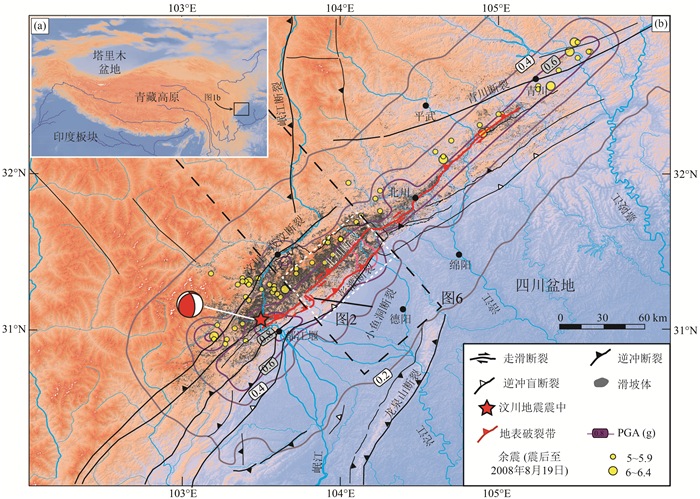
1 研究区概况龙门山位于青藏高原东缘,是高原和四川盆地之间的边界过渡区,最为明显的地貌特征是在不到50 km的范围内,由高原东缘向四川盆地平均海拔从4000 m陡降至500 m,地形梯度达到0.06(Godard et al., 2009).龙门山地区从南到北依次有大渡河、青衣江、岷江、沱江、涪江和嘉陵江横穿山地,形成深切河谷地貌,与深部的构造活动共同造就了龙门山地区地形起伏度大、坡度陡的地形地貌特征(图 1).龙门山地区气候主要受亚洲东南季风影响,降雨大多集中在6—9月,占全年总降雨量的70%左右,峰值一般出现在7月和8月(Liu-Zeng et al., 2011;文力等,2012);龙门山降雨量还具有明显的山地气候特征,四川盆地平原区平均年降雨量可达1000mm,受造山带影响往北西方向降雨量随海拔增高而逐渐降低,在高原面上减至600 mm (New et al., 2002).
|
图 1 龙门山地区地形、活动断裂与主要河流、以及汶川地震同震地表破裂和滑坡分布图 Fig. 1 Topography, active faults, and major fluvial systems in the Longmen Shan, and locations of surface rupture and coseismic landslides caused by the Wenchuan earthquake |
龙门山地区沉积和地质构造较为复杂,岩性主要包括扬子克拉通结晶基底、晚元古代-古生代的海相沉积、三叠纪复理石沉积、以及龙门山前缘和四川盆地内中生代-新生代的陆相沉积;山前构造主要受4条近平行的北东向断裂控制,自北西向南东分别是汶川—茂汶断裂、映秀—北川断裂(下文简称为北川断裂)、灌县—安县断裂(下文简称为彭灌断裂)以及龙门山山前的广元—大邑隐伏断裂(图 1;邓起东等,1994;Burchfiel et al., 1995).2008年5月12日发生的汶川地震,震中位于中国四川省汶川县映秀镇与漩口镇交界(30.986°N,103.364°E),震源深度~19 km,震级为MW7.9(USGS National Earthquake Information Center,2008;中国地震局,2009).地表主体破裂带主要沿北川断裂、彭灌断裂,以及夹于两者之间的小鱼洞断裂发育,在北川断裂表现为逆冲兼右旋走滑性质,地表破裂长度约260 km,最大陡坎高度6~11 m,最大右旋走滑位移量为4.9 m;在彭灌断裂为纯逆冲性质,地表破裂长度~70 km,陡坎最大高度为3.5 m (李海兵等,2008;刘静等,2008;徐锡伟等,2008;Liu-Zeng et al., 2009;Xu et al., 2009;Zhang et al., 2010;Fu et al., 2011).
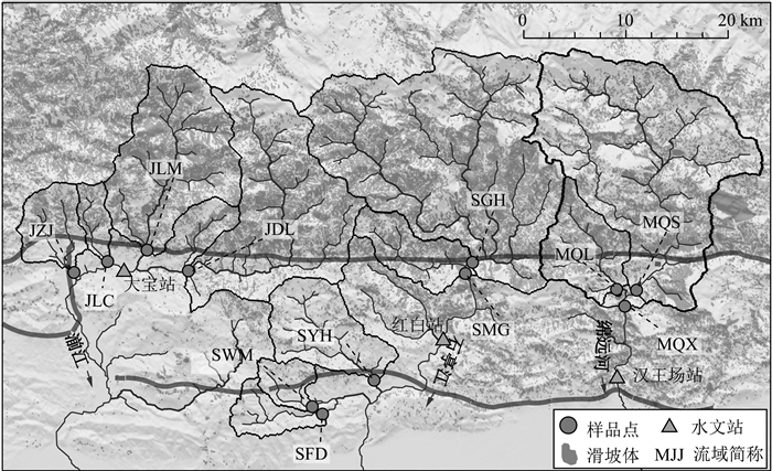
本研究主要位于龙门山前缘沱江上游,包括湔江、石亭江以及绵远河流域,展布在汶川地震同震地表破裂带两侧(图 1和图 2).该地区地形陡峭,并在汶川地震中受到强烈的地面震动(Li et al., 2008;周荣军等,2010),触发了大量的滑坡体.与龙门山其他同震滑坡发育区相似,研究区滑坡体主要受地表破裂、地震动、地形坡度和岩性等因素控制(许强和李为乐,2010;Dai et al., 2011;许冲等,2013;Li et al., 2014),绝大部分展布在北川断裂上盘,而下盘滑坡发育量较少(图 2).据遥感影像分析,沱江上游流域共发育滑坡体~45000个,总滑坡面积~309 km2,占汶川地震同震滑坡总面积的27%(许冲等,2013;Xu et al., 2014),在采样点流域上游,滑坡面积所占流域总面积比例1%~36%不等,为研究同震滑坡对河流运移体系的影响提供了良好的研究场所.
|
图 2 龙门山地区沱江支流现代河沙采样位置以及上游流域范围和滑坡体分布图 Fig. 2 Sampling locations and coseismic landslides within the drainage basins along three tributaries of the Tuojiang River in the Longmen Shan |
本研究主要基于现代河沙石英中的次生宇宙成因核素10Be,对比地震前后10Be浓度变化,计算震后河流河沙运移增量,以及探讨滑坡物质在研究流域内的运移和滞留.
2.1 采样位置及样品测试震前Godard等(2010)在研究区部分流域采集并获得了现代河沙的石英10Be浓度,震后我们在该地区12个流域进行了周期性重复采样,共采集样品29个(表 1,图 2).采样流域大部分位于北川断裂上盘,其中4个采样点位于湔江支流,上游流域分别编号为JZJ,JLC,JLM和JDL;2个采样点位于石亭江,其上游流域分别编号为SMG和SGH;3个采样点位于绵远河,其上游流域分别编号为MQX,MQS和MQL;部分采样流域位于北川断裂下盘石亭江支流,分别编号SFD,SWM和SYH(图 2).
|
|
表 1 采样点位置及河沙石英10Be浓度结果 Table 1 Samples information and 10Be results |
河沙样品主要采集现代河漫滩地表 5 cm以上河流沉积物,以确保所采集的样品能够代表最新一次洪水事件.将采集到的河沙筛选出250~500 μm(部分样品为250~1000 μm)组分用于后期的样品处理和测试;经石英提纯、溶解、阴-阳离子交换、Be(OH)2沉淀以及灼烧等步骤得到BeO;最后将制得的BeO靶样送往法国CNRS实验室完成Be同位素测试(Arnold et al., 2010;2013),获得石英样品中10Be浓度.测试标样为National Institute of Standards and Technology提供的标准物4325,10Be/9Be比值为2.79±0.33×10-11,10Be半衰期为1.36±0.07×106年(Nishiizumi et al., 2007).测试结果见表 1.
2.2 震后河流河沙运移量计算已知某一河流汇流点地震前和地震后河沙10Be浓度的情况下,通过对上游流域滑坡物质10Be浓度的合理设定,可以获得地震前后河流的河沙运移量比值(West et al., 2014;Wang et al., 2017).

|
(1) |
Mpre和Mpost分别是地震前后河流河沙运移量;10Bepre和10Bepost分别为地震前后河沙中石英10Be浓度;10Belandslide为滑坡物质平均10Be浓度,其值主要依据震前流域平均侵蚀速率、地表10Be生成速率、流域内滑坡体分布以及滑坡体几何特征等计算获得,详细计算过程可参考Wang等(2017),本文选取采样点上游临近河网的滑坡体作为震后河流中滑坡碎屑物主要物质来源,用单个滑坡体平均10Be浓度的面积比计算得到流域滑坡物质平均10Be浓度.
对于缺少震前河沙10Be数据的研究流域,本文通过计算给定了一个相对合理的初始震前10Be浓度值,具体方法如下:(1)认为沱江上游相邻流域震前平均流域侵蚀速率无明显差别,有震前10Be浓度的流域可以由10Be获得震前流域平均侵蚀速率,而其他流域采用相邻流域的计算值,即将JLM震前侵蚀速率给予JZJ、JLC和JDL流域;SYH震前侵蚀速率给予SWM和SFD流域;MQX震前侵蚀速率给予MQL和MQS流域;考虑到SGH流域震前侵蚀速率可能被高估(震前SGH流域10Be样品可能受局部滑坡影响,使得其浓度要明显低于临近流域10Be浓度值,Godard et al., 2010;Wang et al., 2017),本文选取MQX流域震前数据作为SGH和SMG流域的震前侵蚀速率.(2)通过Matlab软件计算获得流域内稳定状态下的10Be平均生成速率(Lal,1991;Dunne et al., 1999;Stone,2000).(3)由震前流域内侵蚀速率以及10Be生成速率反推震前稳定状态下的河沙10Be浓度.结果见表 1.
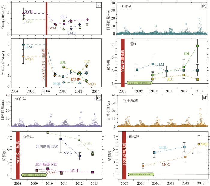
3 结果表 1和图 3a给出了震后不同研究流域的河沙10Be浓度结果,最为明显的特征是:受汶川地震同震滑坡低10Be浓度物质的加入,震后河沙10Be浓度呈现明显降低的趋势.考虑到研究区不同流域内10Be生成速率差别较大,为了消除这种由海拔差异所带来的影响,比较不同流域地震前后10Be浓度变化时本文采用了稀释率(10Bepre/10Bepost)来进行对比,稀释率为1时代表10Be浓度在地震前后无变化,而稀释率越大代表10Be浓度在震后降低程度越大(Wang et al., 2017).从结果中可以看出(图 3b—3d):(1)整体而言,龙门山沱江上游流域在震后10Be浓度较震前存在1.3~7.6倍的稀释变化;(2)对于湔江上游流域(滑坡面积占流域面积比为11%~34%),河沙10Be稀释度存在两种截然不同的演化趋势,一种不随时间发生剧烈的波动(如JLM和JLC流域),另一种则呈现随时间逐渐增加的趋势(如JDL流域);(3)石亭江上游流域明显的分为两部分,位于北川断裂上盘的流域(滑坡面积比例~27%)震后10Be稀释程度较高,而且随着时间呈逐渐降低的趋势;而位于北川断裂下盘的研究区(滑坡面积比例约1%~4%)震后10Be稀释度明显偏低,并随时间逐渐减小;(4)绵远河上游流域(滑坡面积占流域面积比约为18%~23%)震后河沙10Be浓度变化较为一致,随时间有逐渐升高的趋势;(5)与Wang等(2017)结果相似,本文未发现10Be浓度随时间的演化与降雨量存在明显相关性.
|
图 3 (a) 震后河沙10Be浓度随时间的变化;(b)湔江流域10Be稀释度随时间的变化;(c)石亭江流域10Be稀释度随时间的变化;(d)绵远河流域10Be稀释度随时间的变化 Fig. 3 Time series of (a) river sand 10Be concentrations, and 10Be dilution factors in Jianjiang (b), Shiting Jiang (c), and Mianyuan River (d) |
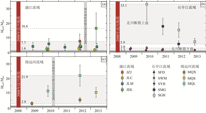
震后河沙运移增量(需注意本文中为250~1000 μm粒度河沙)计算结果显示(表 2,图 4):(1)湔江上游流域在震后河沙运移增量主要在1.6~7.7倍区间,但一个极端例子是JDL流域在2013年的结果显示出高达~16.6倍的河沙侵蚀增量;(2)石亭江北川断裂下盘流域震后河流河沙侵蚀增量为地震之前的1.3~3.0倍,相比之下北川断裂上盘河沙侵蚀增量更大,为原来的5.9~33.1倍;(3)绵远河上游流域震后河流运移增量约为震前的2.8~21.9倍.
|
|
表 2 震后河沙运移增量比以及滑坡碎屑物滞留时间 Table 2 Increase of sediment flux and minimum residence time |
|
图 4 震后研究流域河流运移增量比随时间的变化 Fig. 4 Time series of the relative increase in fluvial sediment flux after the Wenchuan earthquake |
本文给出了龙门山地区河流体系中250~1000 μm推移质在汶川地震前后的运移量变化,补充了水文站悬浮物(< 250 μm)未能量测的中粗-粗砂组分,同时两种基于不同原理和研究方法的结果可以相互对比和验证,以便更好地限定同震滑坡对河沙运移量产生的影响.本文碎屑10Be结果显示受汶川地震同震滑坡影响,震后湔江上游河沙运移量明显增加,为震前的1.3~33倍,高于龙门山地区水文站点观测到的河沙数据的1~10倍(Wang et al., 2015),这种差异可能来源于:(1)两种不同粒度的河沙物质(水文站给出的为 < 250 μm的悬浮物,10Be给出的为250~1000 μm的推移质)震后运移增量确实存在差异性;(2)本次研究区集中在滑坡密度更大的流域,而水文数据受站点位置限制未能捕捉到这种高滑坡密度发育区的震后河沙运移变化;(3)由于河沙中10Be浓度受物质来源,岩性等多方面因素控制,尤其是震后滑坡体10Be浓度难以确定,使得本文计算的结果可能存在一定的误差(Wang et al., 2017),但是水文站点观测的悬浮物通量同样存在观测和计算中的误差(文力等,2012),以及运移增量比计算过程中的误差传递都会使得两种数据结果与实际值可能存在较大偏差,这同时也强调了观测河沙运移量时不同方法相互验证的必要性;除此之外,(4)Wang等(2015)选用的为站点2008—2012年河流悬浮物通量的年平均值,而本文给出的为单独年份的河沙运移增量,因此可能受降雨条件、泥石流等其他因素影响而出现异常高值.
由于龙门山地区地形陡峭,使得该地区在雨季极易形成泥石流,而汶川地震产生的大量滑坡碎屑物堆积在山坡及河谷中,不仅为泥石流的产生提供了丰富的物源,同时也降低了泥石流发育所需要的降雨临界条件(Tang et al., 2009;Xu et al., 2012;Zhang et al., 2014;Zhang and Zhang, 2017).对部分泥石流体积和其上游流域滑坡体积进行对比研究后发现,受流域地形差异以及泥石流发育情况不同,单次强泥石流事件可将0.5%~50%的滑坡碎屑物带出沟口(Tang et al., 2012;Xu et al., 2012;Zhang et al., 2016;Zhang and Zhang, 2017).本次研究区存在大量的泥石流沟谷,因此震后河沙10Be浓度和河沙运移量很可能受泥石流的影响.例如湔江上游白水河流域(即JDL流域)在2012年8月17日—18日强降雨作用下爆发的群发性泥石流灾害(葛永刚等,2012;黄勋等,2013)可能是造成该流域2013年河沙10Be浓度降低(图 3a和图 3b)以及震后河沙运移量猛增(图 4a)的主要因素;同理,2010年8月12—13日在绵远河上游发生的特大山洪泥石流灾害使得大量松散物质被带入到河网中(许强,2010;Tang et al., 2012),可能是引起绵远河上游2010年之后河沙10Be浓度持续降低(图 3a和图 3d)以及河沙运移量逐年增加(图 4c)的主导因素;由于石亭江上游流域人口分布稀疏,目前对于该地区泥石流发育情况报道较少,现还难以确定SGH和SMG流域2010—2012年的高河沙运移量(图 4b)是否与流域内的泥石流有关,但流域内的滑坡面积比高达~27%(Xu et al., 2014)以及流域内发育有大型滑坡体(许强和李为乐,2010)预示着该流域在震后极易发生突发强侵蚀事件.因此,龙门山地区强降雨导致的泥石流可能是震后物质运移量的变化程度以及其随时间演化趋势上的空间差异性的另一主导因素.
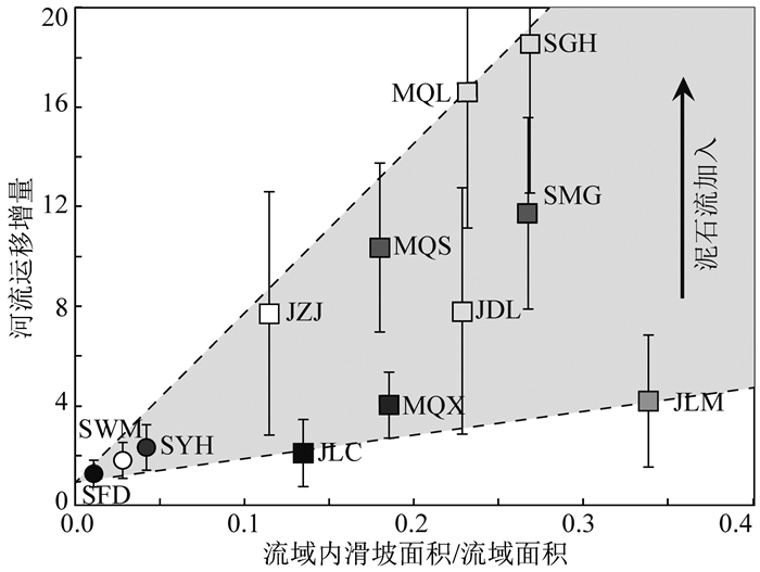
整体来看,研究流域内2009—2013年之间的平均河沙运移增量为1.3~18.5倍(表 2),与震后悬浮物通量变化结果较为一致(Wang et al., 2015).本文与Wang等(2015)给出的河流悬浮物结果以及West等(2014)和Wang等(2017)给出的河沙10Be浓度结果都显示流域内滑坡面积比是控制震后河沙运移量的主要因素(图 5),最为显著的是北川断裂上、下盘流域之间的对比.由于汶川地震同震滑坡分布主要受地表破裂、地震动、地形坡度和岩性等多种因素的联合影响,北川断裂为逆冲断裂,上盘平均海拔高,地形高差和山脊坡度大,同时上盘地震动峰值加速度大于下盘,使得其上盘同震滑坡量要远远大于下盘流域(Ouimet,2010;Dai et al., 2011;Xu et al., 2014),因此使得北川断裂上盘河流震后平均运移增量(2.1~18.5倍)要远远高于断裂下盘流域(1.3~2.3倍)(表 2,图 4和图 5).其他研究流域也基本符合震后河沙运移量与滑坡面积比正相关的关系(图 5),除此之外,相比先前的研究本文认为区域内泥石流的发生同样控制着震后河沙运移量的变化,使得滑坡更为发育的北川断裂上盘具有较大的河流运移增量及区间范围(图 5).总体而言,汶川地震同震滑坡使得河沙运移量在震后有着数倍至十几倍的增加,极大加快了龙门山地区的地表侵蚀速率,而且其增长幅度要高于1999年集集地震对台湾中央山脉河流侵蚀速率的影响(Dadson et al., 2004;Hovius et al., 2011).
|
图 5 震后河沙运移量增量与流域内滑坡面积比之间的关系 Fig. 5 Correlation between the relative increase in fluvial sediment flux and the catchment average landslide density |
震后滑坡物质在震区滞留时间的估算,对预防震后次生灾害的发生以及探讨强震对地形演化影响至关重要,为此本文依据各研究流域上游总滑坡量、震前河沙运移量、以及平均河沙运移增量比值,简单计算了滑坡碎屑物质在这些流域中的滞留时间,结果显示在沱江上游滑坡物质全部运移出研究流域所需要的时间约为97~3874年(表 2).
需要注意的是简单的除法计算可能会使结果与实际滞留时间存在较大的偏差:(1)震后河沙运移增量并不会一直维持在某一范围之内,而是随着时间呈逐渐减小的趋势,集集地震之后河沙运移量仅仅在震后~6年就恢复到了震前水平(Hovius et al., 2011),而汶川地震之后尽管恢复相对较慢,但据估计也会在数年至数十年恢复到震前平均水平(Wang et al., 2015;Wang et al., 2017),除此之外泥石流事件频率的降低同样会使得一个地震周期内的平均河沙运移量要远远低于本文给定的运移量值,因此通过震后开始几年的平均运移增量比来计算会造成滑坡碎屑物滞留时间的低估;(2)由于与河流相通性好的滑坡物质更容易被河流运移带出(Li et al., 2016;Wang et al., 2017),随着这部分碎屑物质的逐渐带离必然会降低滑坡碎屑物与河流的连通性以及河流的运移量;(3)尽管Wang等(2015)和本文针对了两种不同粒度的河沙物质(分别为粘土-细沙和中沙-粗沙)来进行震后的河沙运移量变化研究,并给出了相近的增量比值结果,但该增量比是否能适用于更粗颗粒的河沙物质还值得进一步商榷:一方面在相同水动力环境下,粗颗粒物质更难被运移到河流下游(Paola et al., 1992),使得震后粗颗粒碎屑的河流运移速率可能要远远低于细颗粒物质;而另一方面泥石流的发生会将大量滑坡松散物质带入河网,而这些碎屑物中以粗颗粒物质占主体(Wang et al., 2011;Chen et al., 2012;Wang et al., 2013),这可能会增加震后河流运移物中的粗颗粒比例,从而使得粗颗粒物质具有更高的河流运移增量比.不管怎样,刘锋等(2013)通过水动力模拟的定量估算认为岷江流域震后河流推移质的滑坡河流卸载时间至少为~3100年,与本文给出的滞留时间基本一致.
虽然现阶段对震后物质河流运移速率还存在很多不确定因素,而且难以确定河流推移质中砾石及更粗颗粒物质在震后的运移增量,但是震后5年绵远河清平乡下游至出山口(MQS流域下游)之间的河道共堆积了1.27×10⁷m3的沉积物,是上游泥石流带出物质的两倍(Huang and Li, 2014),尽管计算中未统计其他滑坡体物质的参与,但是如此巨量的物质堆积在河道中可能说明绝大部分的滑坡碎屑物质,尤其是粗颗粒物质,并没有被快速的运移到河流下游而是沉淀停留在河流上游河道中.除此之外,考虑到震后河沙运移量的衰减过程,本研究认为汶川地震同震滑坡物质被运移出龙门山造山带所需要的时间可能要远远大于表 2给出的滞留时间结果.因此,震后滑坡物质的再运移对龙门山地区及下游可能存在长时间的影响,暴雨季节引起的泥石流、洪水等依然是未来几十年龙门山地区需要面临和防范的主要地质灾害(Huang and Fan, 2013).
4.3 强震在龙门山地区地形地貌演化中的作用从短时间尺度上来看,类似汶川地震的强震可以通过同震地表变形(Fielding et al., 2013;刘静等,2015)、同震滑坡以及震后泥石流(Huang and Li, 2014;Liu and Yang, 2015;Zhang et al., 2016)等作用改变区域地形地貌.一方面造成河床抬升,改变河道纵降比等,从而改变震区原有的侵蚀体系;另一方面通过同震滑坡产生的松散碎屑物加速龙门山地区原有的坡面以及河流侵蚀速率(图 4),扰乱震区原有的稳定侵蚀状态(Liu-Zeng et al., 2011).
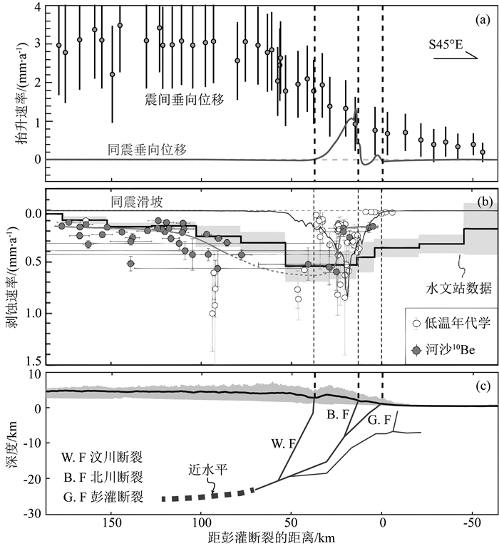
从碰撞造山演化尺度上来看,强震可能是龙门山隆起的主要驱动力之一.尽管Parker等(2011)对比汶川地震同震地表抬升量和滑坡量后认为强震在龙门山前缘造成的是造山带的物质亏损(net material deficit),但过于简单化的对比使得其结论“large earthquake destroy mountainous topography”仍存在很大的争论(Densmore et al., 2012;Molnar,2012).要弄清汶川地震是否造成了龙门山整体上的地表抬升,需要对比地震造成的物质增生量(岩石隆升增加的山脉体积)和物质亏损量(剥蚀减少的山脉体积)(England and Molnar, 1990),其中物质增生量既包括同震引起的地表抬升量,也包括地壳均衡反弹产生的隆升量(Fu et al., 2011;Molnar,2012),而物质亏损量应为同震滑坡在该强震周期内实际被带离出造山带的物质量.本文结果表明汶川地震同震滑坡物质被河流完全带离龙门山造山带所需要的时间至少需要100~4000年(表 2),接近类似汶川地震的强震在龙门山地区的复发周期2000~4000年(Ran et al., 2010;2013;Zhang,2013),因此,同震滑坡物质被全部卸载带离龙门山是一个长时间的过程,其地壳均衡效应不应忽略.同时,地表剥蚀引起的地壳均衡反弹会使得地震造成的物质增生量要大于同震地表抬升量(Molnar,2012);而汶川地震同震滑坡量与同震地表抬升量近似相等(图 6a和6b;Li et al., 2014;Xu et al., 2014),因此,汶川地震造成的物质增生量要大于,至少不小于其引起的物质亏损量,这表示汶川地震更有可能有助于龙门山的地表抬升,在龙门山隆升过程中起到“造山”的作用.
|
图 6 龙门山地区(a)汶川地震同震抬升速率(Fidldiing et al., 2013)以及基于水准数据获得的震前平均抬升速率(Feng et al., 2015);(b)同震滑坡在一个地震周期内的平均侵蚀速率(Xu et al., 2014),震前河沙侵蚀速率(Liu-Zeng et al., 2011),10Be侵蚀速率(Godard et al., 2010; Ansberque et al., 2015),以及低温热年代学侵蚀速率(Arne et al., 1997;Richardson et al., 2008;Godard et al., 2009;Wilson and Fowler, 2011;Wang et al., 2012);(c)深部断裂几何形态(Liu-Zeng et al., 2011, 2017;Li et al., 2016) Fig. 6 Comparison of (a) vertical motion caused by the Wenchuan earthquake (Fielding et al., 2013) and average vertical motion during the intersesimic period (Feng et al., 2015); (b) denudation related to coseimic landslide (Xu et al., 2014), decadal denudation rate from sediment load (Liu-Zeng et al., 2011), millennium erosion rate from cosmogenic nuclide (Godard et al., 2010; Ansberque et al., 2015), Myr-scale erosion rate from low temperature chronology (Arne et al., 1997; Richardson et al., 2008; Godard et al., 2009; Wilson et al., 2011; Wang et al., 2012), and (c) subsurface fault geometry (Liu-Zeng et al., 2011, 2017; Li et al., 2016) |
为了进一步对比龙门山前缘在强震时和震间平静期的地表抬升速率和河流侵蚀速率,我们以3000年为地震复发周期计算了汶川地震引起的抬升速率和剥蚀速率,并与震前水准获得的平均抬升速率及水文站、河沙10Be和低温热年代学获得的平均剥蚀速率进行了对比(图 6a和图 6b).汶川地震同震地表抬升量和滑坡量分别基于InSAR和卫星影像数据获得(Fidlding et al., 2013;Xu et al., 2014),需要注意的是本文按照总滑坡量计算得到的剥蚀速率,未考虑震后实际运移情况,结果可能偏高但不影响总体特征.水准测量得到的震前地表抬升速率呈现出向高原内部逐渐升高的空间分布特征(水准测量由于误差传递问题,其获得的抬升速率值可能偏高,图 6a,Hao et al., 2014;Feng et al., 2015);而汶川地震同震抬升则主要发生在龙门山山前,尤其是北川断裂上盘~20 km范围内,造成的平均抬升速率最高可达1~1.5 mm·a-1(图 6a;Fidlding et al., 2013),与浅层勘探和第四纪钻井(Li et al., 2016)以及古地震(Densmore et al., 2007;Ran et al., 2013)得到的龙门山山前断裂带第四纪以来的平均形变速率一致.综上,我们认为震间与同震变形存在空间上的互补,北川断裂和彭灌断裂几何上的“铲型”结构(图 6c)使得震间期断裂浅部脆性区段闭锁,此时应变发生在比较宽的范围,甚至到远离断裂带的区间,而强震时应力的快速释放使得震间累计的上地壳弹性应变最终在北川断裂和彭灌断裂以不可恢复的破裂位移表现出来(Zhang et al., 2010).因此,震间的地表垂向位移和震时的地表破裂共同控制了龙门山山前的地壳变形,这种震间与震时地表垂向位移的互补性在其他造山带前缘也得到了证实,例如喜马拉雅前缘(Vergne et al., 2001;刘静等,2015).
除了对地壳变形的控制,汶川地震对龙门山地区地表侵蚀空间分布也具有非常重要的影响.震前河沙10Be数据表明北川断裂上盘彭灌杂岩地区千年尺度流域平均侵蚀速率仅为0.2~0.3 mm·a-1,要远远低于紧邻的岷江支流流域(Godard et al., 2010;Ansberque et al., 2015),这与龙门山深部活动断裂分布及地形地貌特征显然是不匹配的(图 6b和6c).Godard等(2010)认为彭灌杂岩地区的低侵蚀速率和高地形可能与该地区岩石强度较高有关,但是也不能排除河沙10Be获得的千年尺度侵蚀速率可能缺失了地震造成的强侵蚀过程而使得结果偏低(Ouimet,2010).实际上,汶川地震增加了北川断裂上盘的侵蚀速率(图 4,West et al., 2014;Wang et al., 2015, 2017),其在地震周期内引起的平均剥蚀速率甚至可以达到~0.9 mm·a-1.如果将震前平均侵蚀速率以及地震带来的剥蚀速率进行相加,可以发现北川断裂上盘~50 km范围内可能具有较为一致的剥蚀速率0.7~1.1 mm·a-1,这一结果与低温热年代学磷灰石裂变径迹得到的百万年尺度剥蚀速率较为一致(图 6b,Arne et al., 1997;Wilson et al., 2011).因此,对于北川断裂彭灌杂岩地区,震前的低侵蚀速率更可能是没有考虑到高强度小概率事件(如汶川地震)在长期侵蚀过程中所起的作用(Ouimet,2010;文力等,2012).
5 结论通过上述分析,本文得出如下初步结论和认识:
(1) 震后沱江上游流域现代河沙中的石英10Be浓度受同震滑坡物质影响呈现明显的降低,表明了震后滑坡物质大量加入到河流体系.
(2) 同震滑坡加速了龙门山地区的河流侵蚀速率,河沙10Be计算结果显示震后5年内沱江上游平均河沙运移量是震前的1.3~18.5倍,与水文站点获得的河流悬浮物通量结果基本一致;除此之外,震后强降雨引发的泥石流可能造成了部分流域具有异常高的河沙运移量.
(3) 汶川同震滑坡物质被全部带离出龙门山所需要的时间至少为100~4000年,接近该地区的强震复发周期,其引起的地壳均衡效应在龙门山地形演化中不应忽略.
(4) 汶川地震通过同震破裂的形式改变龙门山前缘的地壳变形,又以同震滑坡影响着地表侵蚀,这种脉冲式的高强度小概率事件与震间平静期的地表抬升和侵蚀共同控制着龙门山山前的抬升速率和剥蚀速率,在青藏高原东缘长期地形演化中具有非常重要的作用.
致谢感谢中国科学院地球环境研究所董国成博士及法国科学研究中心加速质谱实验室工作人员在样品制备和测试中给予的帮助.感谢审稿人以及地球物理学报杂志社编辑对本文修正和改进给予的帮助.
Ansberque C, Godard V, Bellier O, et al.
2015. Denudation pattern across the Longriba fault system and implications for the geomorphological evolution of the eastern Tibetan margin. Geomorphology, 246: 542-557.
DOI:10.1016/j.geomorph.2015.07.017 |
|
Arne D, Worley B, Wilson C, et al.
1997. Differential exhumation in response to episodic thrusting along the eastern margin of the Tibetan Plateau. Tectonophysics, 280(3-4): 239-256.
DOI:10.1016/S0040-1951(97)00040-1 |
|
Arnold M, Merchel S, Bourlès D L, et al.
2010. The French accelerator mass spectrometry facility ASTER: Improved performance and developments. Nuclear Instruments and Methods in Physics Research Section B: Beam Interactions with Materials and Atoms, 268(11-12): 1954-1959.
DOI:10.1016/j.nimb.2010.02.107 |
|
Arnold M, Aumaître G, Bourlès D L, et al.
2013. The French accelerator mass spectrometry facility ASTER after 4 years: Status and recent developments on 36Cl and 129I. Nuclear Instruments and Methods in Physics Research Section B: Beam Interactions with Materials and Atoms, 294: 24-28.
DOI:10.1016/j.nimb.2012.01.049 |
|
Burchfiel B C, Chen Z L, Liu Y P, et al.
1995. Tectonics of the Longmen Shan and adjacent regions, central China. International Geology Review, 37(8): 661-735.
DOI:10.1080/00206819509465424 |
|
Chen H X, Zhang L M, Chang D S, et al.
2012. Mechanisms and runout characteristics of the rainfall-triggered debris flow in Xiaojiagou in Sichuan Province, China. Natural Hazards, 62(3): 1037-1057.
DOI:10.1007/s11069-012-0133-5 |
|
China Earthquake Administration. 2009. Focal depth of M8. 0 Wenchuan earthquake. (in Chinese). http://www.cea.gov.cn/manage/html/8a8587881632fa5c0116674a018300cf/_content/09_05/08/1241779378191.html.
|
|
Dadson S J, Hovius N, Chen H, et al.
2004. Earthquake-triggered increase in sediment delivery from an active mountain belt. Geology, 32(8): 733-736.
DOI:10.1130/G20639.1 |
|
Dai F C, Xu C, Yao X, et al.
2011. Spatial distribution of landslides triggered by the 2008 MS8.0 Wenchuan earthquake, China. Journal of Asian Earth Sciences, 40(4): 883-895.
DOI:10.1016/j.jseaes.2010.04.010 |
|
Deng Q D, Chen S F, Zhao X L.
1994. Tectonics, scismisity and dynamics of Longmenshan Mountains and its adjacent regions. Seismology and Geology (in Chinese), 16(4): 389-403.
|
|
Densmore A L, Ellis M A, Li Y, et al.
2007. Active tectonics of the Beichuan and Pengguan faults at the eastern margin of the Tibetan Plateau. Tectonics, 26(4): TC4005.
DOI:10.1029/2006TC001987 |
|
Densmore A L, Parker R N, Rosser N J, et al.
2012. Reply to 'Isostasy can't be ignored'. Nature Geoscience, 5(2): 83-84.
|
|
Dunne J, Elmore D, Muzikar P.
1999. Scaling factors for the rates of production of cosmogenic nuclides for geometric shielding and attenuation at depth on sloped surfaces. Geomorphology, 27(1-2): 3-11.
DOI:10.1016/S0169-555X(98)00086-5 |
|
England P, Molnar P.
1990. Surface uplift, uplift of rocks, and exhumation of rocks. Geology, 18(12): 1173-1177.
DOI:10.1130/0091-7613(1990)018<1173:SUUORA>2.3.CO;2 |
|
Fan X M, Van Westen C J, Korup O, et al.
2012. Transient water and sediment storage of the decaying landslide dams induced by the 2008 Wenchuan earthquake, China. Geomorphology, 171-172: 58-68.
DOI:10.1016/j.geomorph.2012.05.003 |
|
Feng S Y, Zhang P Z, Liu B J, et al.
2015. Deep crustal deformation of the Longmen Shan, eastern margin of the Tibetan Plateau, from seismic reflection and finite element modeling. Journal of Geophysical Research: Solid Earth, 121(2): 767-787.
|
|
Fidlding E J, Sladen A, Li Z H, et al.
2013. Kinematic fault slip evolution source models of the 2008 M7.9 Wenchuan earthquake in China from SAR interferometry, GPS and teleseismic analysis and implications for Longmen Shan tectonics. Geophysical Journal International, 194(2): 1138-1166.
DOI:10.1093/gji/ggt155 |
|
Fu B H, Shi P L, Guo H D, et al.
2011. Surface deformation related to the 2008 Wenchuan earthquake, and mountain building of the Longmen Shan, eastern Tibetan Plateau. Journal of Asian Earth Sciences, 40(4): 805-824.
DOI:10.1016/j.jseaes.2010.11.011 |
|
Ge Y G, Song G H, Guo Z X, et al.
2012. Characteristics and causes of 8. 18 debris flow hazards at the Longmenshan Town, Pengzhou, Sichuan. Journal of Hydraulic Engineering (in Chinese), 43(S2): 147-154.
|
|
Godard V, Pik R, Lavé J, et al.
2009. Late Cenozoic evolution of the central Longmen Shan, eastern Tibet: Insight from (U-Th)/He thermochronometry. Tectonics, 28(5): TC5009.
DOI:10.1029/2008TC002407 |
|
Godard V, Lavé J, Carcaillet J, et al.
2010. Spatial distribution of denudation in Eastern Tibet and regressive erosion of plateau margins. Tectonophysics, 491(1-4): 253-274.
DOI:10.1016/j.tecto.2009.10.026 |
|
Hao M, Wang Q L, Shen Z K, et al.
2014. Present day crustal vertical movement inferred from precise leveling data in eastern margin of Tibetan Plateau. Tectonophysics, 632: 281-292.
DOI:10.1016/j.tecto.2014.06.016 |
|
Hovius N, Meunier P, Lin C W, et al.
2011. Prolonged seismically induced erosion and the mass balance of a large earthquake. Earth and Planetary Science Letters, 304(3-4): 347-355.
DOI:10.1016/j.epsl.2011.02.005 |
|
Huang R Q.
2011. After effect of geohazards induced by the Wenchuan earthquake. Journal of Engineering Geology (in Chinese), 19(2): 145-151.
|
|
Huang R Q, Fan X M.
2013. The landslide story. Nature Geoscience, 6(5): 325-326.
DOI:10.1038/ngeo1806 |
|
Huang R Q, Li W L.
2014. Post-earthquake landsliding and long-term impacts in the Wenchuan earthquake area, China. Engineering Geology, 182: 111-120.
DOI:10.1016/j.enggeo.2014.07.008 |
|
Huang X, Tang C, Le M H, et al.
2013. Mechanism and characteristics on debris flow hazards in Yinchanggou area triggered by rainstorm on August 18. Journal of Engineering Geology (in Chinese), 21(5): 761-769.
|
|
Koi T, Hotta N, Ishigaki I, et al.
2008. Prolonged impact of earthquake-induced landslides on sediment yield in a mountain watershed: The Tanzawa region, Japan. Geomorphology, 101(4): 692-702.
DOI:10.1016/j.geomorph.2008.03.007 |
|
Lal D.
1991. Cosmic ray labeling of erosion surfaces: In situ nuclide production rates and erosion models. Earth and Planetary Science Letters, 104(2-4): 424-439.
DOI:10.1016/0012-821X(91)90220-C |
|
Li G, West A J, Densmore A L, et al.
2014. Seismic mountain building: Landslides associated with the 2008 Wenchuan earthquake in the context of a generalized model for earthquake volume balance. Geochemistry, Geophysics, Geosystems, 15(4): 833-844.
DOI:10.1002/ggge.v15.4 |
|
Li G, West A J, Densmore A L, et al.
2016. Connectivity of earthquake-triggered landslides with the fluvial network: Implications for landslide sediment transport after the 2008 Wenchuan earthquake. Journal of Geophysical Research: Earth Surface, 121(4): 703-724.
DOI:10.1002/2015JF003718 |
|
Li H B, Fu X F, Van Der Woerd J, et al.
2008. Co-seisimic surface rupture and dextral-slip oblique thrusting of the MS8.0 Wenchuan earthquake. Acta Geologica Sinica (in Chinese), 82(12): 1623-1643.
|
|
Li X J, Zhou Z H, Yu H Y, et al.
2008. Strong motion observations and recordings from the great Wenchuan Earthquake. Earthquake Engineering and Engineering Vibration, 7(3): 235-246.
DOI:10.1007/s11803-008-0892-x |
|
Li Z G, Liu-Zeng J, Jia D, et al.
2016. Quaternary activity of the range front thrust system in the Longmen Shan piedmont, China, revealed by seismic imaging and growth strata. Tectonics, 35(12): 2807-2827.
DOI:10.1002/2015TC004093 |
|
Lin G W, Chen H, Chen Y H, et al.
2008. Influence of typhoons and earthquakes on rainfall-induced landslides and suspended sediments discharge. Engineering Geology, 97(1-2): 32-41.
DOI:10.1016/j.enggeo.2007.12.001 |
|
Liu F, Fu B H, Yang S H.
2013. Time response of river evacuation of great earthquake-induced landslide mass in the Longmen Shan region: A cast study of the 2008 Wenchuan great earthquake. Chinese Journal of Geophysics (in Chinese), 56(5): 1517-1525.
DOI:10.6038/cjg20130510 |
|
Liu F, Yang S H.
2015. The effect of the Wenchuan earthquake on the fluvial morphology in the Longmen Shan, eastern Tibetan Plateau: Discussion and speculation. Quaternary International, 371: 280-289.
DOI:10.1016/j.quaint.2014.09.021 |
|
Liu J, Zhang Z H, Wen L, et al.
2008. The MS8.0 Wenchuan earthquake co-seismic rupture and its tectonic implications—An out-of sequence thrusting event with slip partitioned on multiple faults. Acta Geologica Sinica (in Chinese), 82(12): 1707-1722.
|
|
Liu J, Ji C, Zhang J Y, et al.
2015. Tectonic setting and general features of coseismic rupture of the 25 April, 2015 MW7.8 Gorkha, Nepal earthquake. Chinese Science Bulletin (in Chinese), 60(27): 2640-2655.
|
|
Liu-Zeng J, Zhang Z, Wen L, et al.
2009. Co-seismic ruptures of the 12 May 2008, MS8.0 Wenchuan earthquake, Sichuan: East-west crustal shortening on oblique, parallel thrusts along the eastern edge of Tibet. Earth and Planetary Science Letters, 286(3-4): 355-370.
DOI:10.1016/j.epsl.2009.07.017 |
|
Liu-Zeng J, Wen L, Oskin M, et al.
2011. Focused modern denudation of the Longmen Shan margin, eastern Tibetan Plateau. Geochemistry Geophysics Geosystems, 12(11): Q11007.
DOI:10.1029/2011GC003652 |
|
Liu-Zeng J, Wang P, Zhang Z H, et al.
2017. Liquefaction in western Sichuan Basin during the 2008 MW7.9 Wenchuan earthquake, China. Tectonophysics, 694: 214-238.
DOI:10.1016/j.tecto.2016.11.001 |
|
Molnar P.
2012. Isostasy can't be ignored. Nature Geoscience, 5(2): 83.
|
|
New M, Lister D, Hulme M, et al.
2002. A high-resolution data set of surface climate over global land areas. Climate Research, 21(1): 1-25.
|
|
Ni H Y, Zheng W M, Tie Y B, et al.
2012. Formation and characteristics of post-earthquake debris flow: A case study from Wenjia gully in Mianzhu, Sichuan, SW China. Natural Hazards, 61(2): 317-335.
DOI:10.1007/s11069-011-9914-5 |
|
Nishiizumi K, Imamura M, Caffee M W, et al.
2007. Absolute calibration of 10Be AMS standards. Nuclear Instruments and Methods in Physics Research Section B: Beam Interactions with Materials and Atoms, 258(2): 403-413.
DOI:10.1016/j.nimb.2007.01.297 |
|
Ouimet W B.
2010. Landslides associated with the May 12, 2008 Wenchuan earthquake: Implications for the erosion and tectonic evolution of the Longmen Shan. Tectonophysics, 491(1-4): 244-252.
DOI:10.1016/j.tecto.2009.09.012 |
|
Paola C, Parker G, Seal R, et al.
1992. Downstream fining by selective deposition in a laboratory flume. Science, 258(5089): 1757-1760.
DOI:10.1126/science.258.5089.1757 |
|
Parker R N, Densmore A L, Rosser N J, et al.
2011. Mass wasting triggered by the 2008 Wenchuan earthquake is greater than orogenic growth. Nature Geoscience, 4(7): 449-452.
DOI:10.1038/ngeo1154 |
|
Pearce A J, Watson A J.
1986. Effects of earthquake-induced landslides on sediment budget and transport over a 50-yr period. Geology, 14(1): 52-55.
DOI:10.1130/0091-7613(1986)14<52:EOELOS>2.0.CO;2 |
|
Ran Y K, Chen L C, Chen J, et al.
2010. Paleoseismic evidence and repeat time of large earthquakes at three sites along the Longmenshan fault zone. Tectonophysics, 491(1-4): 141-153.
DOI:10.1016/j.tecto.2010.01.009 |
|
Ran Y K, Chen W S, Xu X W, et al.
2013. Paleoseismic events and recurrence interval along the Beichuan-Yingxiu fault of Longmenshan fault zone, Yingxiu, Sichuan, China. Tectonophysics, 584: 81-90.
DOI:10.1016/j.tecto.2012.07.013 |
|
Richardson N J, Densmore A L, Seward D, et al.
2008. Extraordinary denudation in the Sichuan Basin: Insights from low-temperature thermochronology adjacent to the eastern margin of the Tibetan Plateau. Journal of Geophysical Research: Solid Earth, 113(B4): B04409.
DOI:10.1029/2006JB004739 |
|
Stone J O.
2000. Air pressure and cosmogenic isotope production. Journal of Geophysical Research, 105(B10): 23753-23759.
DOI:10.1029/2000JB900181 |
|
Tang C, Zhu J, Li W L, et al.
2009. Rainfall-triggered debris flows following the Wenchuan earthquake. Bulletin of Engineering Geology and the Environment, 68(2): 187-194.
DOI:10.1007/s10064-009-0201-6 |
|
Tang C, Van Asch T W J, Chang M, et al.
2012. Catastrophic debris flows on 13 August 2010 in the Qingping area, southwestern China: The combined effects of a strong earthquake and subsequent rainstorms. Geomorphology, 139-140: 559-576.
DOI:10.1016/j.geomorph.2011.12.021 |
|
USGS National Earthquake Information Center. 2008. M7. 9-Eastern Sichuan, China. https://earthquake.usgs.gov/earthquakes/eventpage/usp000g650#origin.
|
|
Vergne J, Cattin R, Avouac J P.
2001. On the use of dislocations to model interseismic strain and stress build-up at intracontinental thrust faults. Geophysical Journal International, 147(1): 155-162.
DOI:10.1046/j.1365-246X.2001.00524.x |
|
Wang E, Kirby E, Furlong K P, et al.
2012. Two-phase growth of high topography in eastern Tibet during the Cenozoic. Nature Geoscience, 5(9): 640-645.
DOI:10.1038/ngeo1538 |
|
Wang G H, Huang R Q, Kamai T, et al.
2013. The internal structure of a rockslide dam induced by the 2008 Wenchuan (MW7.9) earthquake, China. Engineering Geology, 156: 28-36.
DOI:10.1016/j.enggeo.2013.01.004 |
|
Wang J, Jin Z D, Hilton R G, et al.
2015. Controls on fluvial evacuation of sediment from earthquake-triggered landslides. Geology, 43(2): 115-118.
DOI:10.1130/G36157.1 |
|
Wang W, Godard V, Liu-Zeng J, et al.
2017. Perturbation of fluvial sediment fluxes following the 2008 Wenchuan earthquake. Earth Surface Processes and Landforms, 42(15): 2611-2622.
DOI:10.1002/esp.v42.15 |
|
Wang Z Y, Shi W J, Liu D D.
2011. Continual erosion of bare rocks after the Wenchuan earthquake and control strategies. Journal of Asian Earth Sciences, 40(4): 915-925.
DOI:10.1016/j.jseaes.2010.07.004 |
|
Wen L, Liu J, Oskin M, et al.
2012. Pattern of modern denudation in the Longmen Shan, eastern Tibetan Plateau: Tectonic controls on focused erosion along the plateau margin. Quaternary Science (in Chinese), 32(5): 968-985.
|
|
West A J, Hetzel R, Li G, et al.
2014. Dilution of 10Be in detrital quartz by earthquake-induced landslides: Implications for determining denudation rates and potential to provide insights into landslide sediment dynamics. Earth and Planetary Science Letters, 396: 143-153.
DOI:10.1016/j.epsl.2014.03.058 |
|
Wilson C J L, Fowler A P.
2011. Denudational response to surface uplift in east Tibet: Evidence from apatite fission-track thermochronology. GSA Bulletin, 123(9-10): 1966-1987.
DOI:10.1130/B30331.1 |
|
Xu C, Xu X W, Wu X Y, et al.
2013. Detailed catalog of landslides triggered by the 2008 Wenchuan earthquake and statistical analyses of their spatial distribution. Journal of Engineering Geology (in Chinese), 21(1): 25-44.
|
|
Xu C, Xu X W, Yao X, et al.
2014. Three (nearly) complete inventories of landslides triggered by the May 12, 2008 Wenchuan MW7.9 earthquake of China and their spatial distribution statistical analysis. Landslides, 11(3): 441-461.
DOI:10.1007/s10346-013-0404-6 |
|
Xu Q, Li W L.
2010. Distribution of large-scale landslides induced by the Wenchuan earthquake. Journal of Engineering Geology (in Chinese), 18(6): 818-826.
|
|
Xu Q.
2010. The 13 August 2010 catastrophic debris flow in Sichuan Province: Characteristics, genetic mechanism and suggestions. Journal of Engineering Geology (in Chinese), 18(5): 596-608.
|
|
Xu Q, Zhang S, Li W L, et al.
2012. The 13 August 2010 catastrophic debris flows after the 2008 Wenchuan earthquake, China. Natural Hazards and Earth System Sciences, 12(1): 201-216.
DOI:10.5194/nhess-12-201-2012 |
|
Xu X W, Wen X Z, Ye J Q, et al.
2008. The MS8.0 Wenchuan earthquake surface ruptures and its seismogenic structure. Seismology and Geology (in Chinese), 30(3): 597-629.
|
|
Xu X W, Wen X Z, Yu G H, et al.
2009. Coseismic reverse-and oblique-slip surface faulting generated by the 2008 MW7.9 Wenchuan earthquake, China. Geology, 37(6): 515-518.
DOI:10.1130/G25462A.1 |
|
Zhang P Z, Wen X Z, Shen Z K, et al.
2010. Oblique, high-angle, listric-reverse faulting and associated development of strain: The Wenchuan earthquake of May 12, 2008, Sichuan, China. Annual Review of Earth and Planetary Sciences, 38(1): 353-382.
DOI:10.1146/annurev-earth-040809-152602 |
|
Zhang P Z.
2013. Beware of slowly slipping faults. Nature Geoscience, 6(5): 323-324.
DOI:10.1038/ngeo1811 |
|
Zhang S, Zhang L M, Lacasse S, et al.
2016. Evolution of mass movements near epicentre of Wenchuan earthquake, the First Eight Years. Scientific Reports, 6: 36154.
DOI:10.1038/srep36154 |
|
Zhang S, Zhang L M.
2017. Impact of the 2008 Wenchuan earthquake in China on subsequent long-term debris flow activities in the epicentral area. Geomorphology, 276: 86-103.
DOI:10.1016/j.geomorph.2016.10.009 |
|
Zhang Y S, Cheng Y L, Yin Y P, et al.
2014. High-position debris flow: A long-term active geohazard after the Wenchuan earthquake. Engineering Geology, 180: 45-54.
DOI:10.1016/j.enggeo.2014.05.014 |
|
Zhou R J, Lai M, Yu H, et al.
2010. Strong motion records of Wenchuan MS8.0 earthquake from digital strong earthquake networks in Sichuan and its neighbouring regions. Chinese Journal of Rock Mechanics and Engineering (in Chinese), 29(9): 1850-1858.
|
|
邓起东, 陈社发, 赵小麟.
1994. 龙门山及其邻区的构造和地震活动及动力学. 地震地质, 16(4): 389–403.
|
|
葛永刚, 宋国虎, 郭朝旭, 等.
2012. 四川彭州龙门山镇8·18泥石流灾害特征与成灾模式分析. 水利学报, 43(S2): 147–154.
|
|
黄润秋.
2011. 汶川地震地质灾害后效应分析. 工程地质学报, 19(2): 145–151.
|
|
黄勋, 唐川, 乐茂华, 等.
2013. 汶川震区银厂沟区域8·18暴雨泥石流灾害成灾机理与特征. 工程地质学报, 21(5): 761–769.
|
|
李海兵, 付小方, Van Der WoerdJ, 等.
2008. 汶川地震(MS8.0)地表破裂及其同震右旋斜向逆冲作用. 地质学报, 82(12): 1623–1643.
DOI:10.3321/j.issn:0001-5717.2008.12.002 |
|
刘锋, 付碧宏, 杨顺虎.
2013. 龙门山地区类似2008年汶川大地震滑坡物质河流卸载时间的定量估算. 地球物理学报, 56(5): 1517–1525.
DOI:10.6038/cjg20130510 |
|
刘静, 张智慧, 文力, 等.
2008. 汶川8级大地震同震破裂的特殊性及构造意义——多条平行断裂同时活动的反序型逆冲地震事件. 地质学报, 82(12): 1707–1722.
DOI:10.3321/j.issn:0001-5717.2008.12.007 |
|
刘静, 纪晨, 张金玉, 等.
2015. 2015年4月25日尼泊尔MW7.8级地震的孕震构造背景和特征. 科学通报, 60(27): 2640–2655.
|
|
文力, 刘静, OskinM, 等.
2012. 活动构造对高原边界侵蚀速率空间分布的控制作用——以龙门山地区为例. 第四纪研究, 32(5): 968–985.
|
|
许冲, 徐锡伟, 吴熙彦, 等.
2013. 2008年汶川地震滑坡详细编目及其空间分布规律分析. 工程地质学报, 21(1): 25–44.
|
|
许强, 李为乐.
2010. 汶川地震诱发大型滑坡分布规律研究. 工程地质学报, 18(6): 818–826.
|
|
许强.
2010. 四川省8·13特大泥石流灾害特点、成因与启示. 工程地质学报, 18(5): 596–608.
|
|
徐锡伟, 闻学泽, 叶建青, 等.
2008. 汶川MS8.0地震地表破裂带及其发震构造. 地震地质, 30(3): 597–629.
|
|
中国地震局. 2009. 汶川8. 0级地震的震源深度. http://www.cea.gov.cn/manage/html/8a8587881632fa5c0116674a018300cf/_content/09_05/08/1241779378191.html.
|
|
周荣军, 赖敏, 余桦, 等.
2010. 汶川MS8.0地震四川及邻区数字强震台网记录. 岩石力学与工程学报, 29(9): 1850–1858.
|
|
 2018, Vol. 61

