2. 中国地质调查局泥质海岸带地质环境重点实验室, 天津 300170;
3. 新疆地矿局第一水文工程地质大队, 乌鲁木齐 830091;
4. 新疆地矿局第二水文工程地质大队, 新疆昌吉 831100
2. CGS Key Laboratory of Muddy Coast Geo-environment, Tianjin 300170, China;
3. No.1 Hydrological and Engineering Geology Party of Xinjiang Bureau of Geology and Mineral Resources Exploration and Development, Urumqi 830091, China;
4. No.2 Hydrological and Engineering Geology Party of Xinjiang Bureau of Geology and Mineral Resources Exploration and Development, Xinjiang Changji 831100, China
塔里木盆地的沉积记录对于理解青藏高原隆升、亚洲内陆干旱化乃至全球气候变化至关重要(Avouac et al., 1993; An et al., 2001; Huang et al., 2006; 孙继敏和朱日祥, 2006; Sun et al., 2017).高原隆升和全球气候变冷可能是导致亚洲内陆干旱气候产生的重要驱动因素,高原隆升和气候变冷导致的风化剥蚀产物最终输入盆地,构成了盆地巨厚松散沉积物及沙漠形成的物质条件和气候条件(Sun et al., 2009a; 郑洪波等, 2009).尽管国内外科学家围绕青藏高原隆升时间进行了大量的研究,但对高原主要的构造变形和隆升时间仍然出现多种不同的观点,从始新世到渐新世(Chung et al., 1998; Rowley and Currie, 2006; Wang et al., 2008; Liu et al., 2017; Zheng, 2016)、中晚中新世(Coleman and Hodges, 1995; Spicer et al., 2003; Clift et al., 2006; Huang et al., 2006; 邓涛等, 2011; 张利云等, 2012)、上新世(Métivier et al., 1998; Zheng et al., 2000)甚至早更新世(李吉均等, 1979; 李吉均, 1999)均有报道.这些研究结果的不同主要是由于对陆块变形年龄约束研究方法不同或区域性隆升导致的.因此,目前很难区分高原隆升的气候效应和全球气候变化对亚洲干旱化进程的贡献.
塔里木盆地地处青藏高原北部,南侧为阿尔金走滑断裂带,西南侧为帕米尔—西昆仑造山带,北侧为天山构造带.这些构造活动控制了盆地的形成演化和环境变迁,使盆地晚新生代沉积环境变得较为复杂,盆地内部地层变化多样,区域上很难进行统一的对比.比如,具有区域标志性的西域砾岩底界年龄在天山南北不同地点显著不同,变化于1.0—7.6 Ma(陈杰等, 2007; Charreau et al., 2009; Huang et al., 2010).西域砾岩年龄的不确定性,使得很难准确建立它与具体的构造作用或气候变化事件的关系(孙继敏和朱日祥, 2006;陈杰等, 2007).目前关于塔里木盆地的地层年代学研究主要集中盆地北缘和西南缘(Charreau et al., 2009; Huang et al., 2010; Sun et al., 2011; Chang et al., 2014),盆地东北缘研究相对较少,因此对塔里木盆地东北缘年代地层与晚新生代构造变形的关系研究仍需加强.但是由于盆地大部分区域被第四纪沉积物覆盖,因此需要利用钻孔来建立不同构造单元可靠的年代地层框架,并以此为基础,探讨塔里木盆地干旱化进程的动力机制、区域构造活动及全球气候变化的关系.
孔雀河是塔里木盆地东北缘的重要河流,其带来的大量物质在库尔勒地区广泛沉积,与山区洪水搬运来的物质共同形成了厚层的山前冲洪积地层,记录了丰富的周缘山体隆升与气候变迁的地质信息.由于塔里木盆地周缘第四纪研究很不平衡,对塔里木盆地东北缘库尔勒地区晚新生代地层时代划分和古环境研究相对较少,一方面是因为缺少高质量的深孔记录,另一方面是缺少对于长序列地层年代的研究.近年来,随着磁性地层研究领域的实验条件和测试技术的不断发展,在新生代不同类型沉积物的年代学研究中取得重要进展,成为建立长尺度地层年代的主要手段(Guo et al., 2002; Deng et al., 2006; 朱日祥等, 2007; Xu et al., 2017; Li et al., 2013).鉴于此,本文研究了在库尔勒地区的ZK3、ZK5钻孔,建立其高分辨率的磁性地层年代框架,并在此基础上初步探讨该区晚中新世以来沉积环境演化及区域构造活动特征.
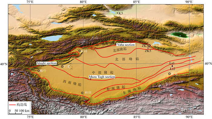
1 研究区地质概况本次研究的两个钻孔位于新疆维吾尔自治区天山南麓,塔里木盆地东北缘孔雀河流域中上游冲洪积平原,地势平坦.该区构造上属于塔北隆起带上的库尔勒鼻状凸起,东北部为库鲁克塔格隆起,南部为倾向西南的孔雀河斜坡带,西南为草湖凹陷(李曰俊等, 2012; Chang et al., 2014; 马庆佑等, 2015).库尔勒鼻状凸起与孔雀河斜坡带之间为孔雀河断裂,是塔里木盆地与库鲁克塔格的分界线,是一条被现代沉积物覆盖而未出露地表的断裂,在喜山期断裂活动强烈(肖晖等,2008).新近系、第四系在研究区广泛发育.两个钻孔处在库尔勒鼻状凸起上,两孔之间构造相对稳定(图 1).

|
图 1 塔里木盆地区域地质构造单元及ZK3、ZK5钻孔位置,该图修改自Chang等(2014) Fig. 1 Sketch map of the Tarim Basin and locations of ZK3, ZK5 boreholes, modified after Chang et al. (2014) |
ZK3钻孔(E86°05′15.8″,N41°42′07.3″)位于阿瓦提乡,孔口高程914.5 m,孔深500 m.ZK5孔(E85°51′42.36″,N41°32′07.53″)位于ZK3孔西南方向约25 km的包头湖农场六分场,孔口高程895.6 m,孔深300 m.ZK3和ZK5孔全孔采心率分别达86.0%和86.7%,采心率和岩心状况满足磁性地层学及其他研究的要求.岩心中泥岩、砂岩层理基本水平,钻孔附近阿瓦提砖厂露头剖面地层产状基本水平(图 2),表明钻孔地层产状基本上是水平的.

|
图 2 阿瓦提砖厂冲洪积沉积剖面 Fig. 2 Alluvial sediments in the section of Awati brickyard |
ZK3、ZK5孔沉积相主要为冲洪积相、河流相、洪泛沉积相,局部夹有薄层的风成沉积相.岩性主要为中粗砂夹砾石、细砂、粉砂、黏土质粉砂和粉质黏土等.依据沉积物的颜色、粒度和沉积构造等特征,ZK3孔500 m厚的地层可归并为12个层段,ZK5孔300 m厚的地层可归并为8个层段(图 3).

|
图 3 ZK3、ZK5钻孔柱状图及岩性描述 Fig. 3 Lithology and sediment grain size of the ZK3 and ZK5 borehole sedimentary sequences |
古地磁样品采集分两步进行,首先是在野外剖开的新鲜岩心面上按岩心的顶底方向定向采集块状样品,然后在室内加工成2 cm×2 cm×2 cm的样品.采样点的确切位置视岩心状况而定,尽量采集钻探过程中无扰动的岩心.黏性土以0.2~0.5 m的间隔采样,砂性土结构密实的用无磁立方体塑料盒采样,间隔1~2 m,砂砾石层不取样,每个采样点平行采集两块样品,共采集平行样品424组,其中,ZK3采集177个、ZK5采集247个.
古地磁测试在中国科学院地质与地球物理研究所古地磁与地质年代学实验室完成.实验采用逐步热退磁方法,热退磁按照20~50 ℃间隔从室温退至585 ℃或690 ℃.系统热退磁在TD-48型全自动热退磁仪上进行.剩磁测量在2G-760R低温超导磁力仪上进行,其灵敏度为10-12Am2,整个实验过程在零磁空间(< 300 nT)完成.
光释光测试在中国地质大学(武汉)构造与油气资源教育部重点实验室完成.四个光释光样品采集在砖场人工开挖的露头剖面上进行,砖场露头剖面与ZK3孔相距10 m,经水准仪高程测量,钻孔孔口高度和露头剖面地表高度相同.钻孔和砖场露头剖面岩性比较结果表明露头剖面岩性与ZK3孔相同深度内岩性一致,露头剖面年代结果可以用于钻孔中相同深度地层年代确认.本次研究取样深度分别为0.3 m、0.5 m、0.7 m、1.8 m,测定矿物为石英.
粒度样品按~2 m的间隔采集,同时兼顾岩性的变化情况,厚砂层沉积段间隔相对大一点,厚度大于0.5 m的夹层必采样,共采集236个样品,其中,ZK3采集132个、ZK5采集104个.粒度测试在天津地质矿产研究所实验室测试完成,采用Microtrac S3500激光粒度分析仪测试,以尤登-沃德华氏等比制Φ值为粒级标准.
3 结果与分析 3.1 ZK3、ZK5孔古地磁结果古地磁测试结果分析采用主成分分析法(Kirschvink, 1980),通过最小二乘法拟合得到每个样品的特征剩磁方向,选择的退磁步骤至少为4个连续的温度点.本次测试两个孔中共有295个样品获得稳定的特征剩磁方向,其中ZK3钻孔中154个样品分离出特征剩磁,ZK5钻孔中141个样品分离出特征剩磁.代表性样品的剩磁矢量正交投影和剩磁衰减曲线显示(图 4、5),189个样品在150~250 ℃之间可退掉黏滞剩磁,热退磁样品在300~560 ℃区间内可获得稳定的特征剩磁方向;112个样品的特征剩磁可保持到600~670 ℃,表明这些沉积物中主要的携磁矿物为磁铁矿和赤铁矿.其余未能分离出特征剩磁的样品为沉积物粒度较粗的砂层或剩磁较弱的样品,这些样品表现出天然剩磁(NRM)特别弱,退磁过程中其剩磁方向极不稳定的特征.由于钻孔岩心的磁偏角发生转动,我们利用Arason和Levi(2010)方法计算了这两个钻孔的正负极性平均倾角值,并尝试进行倒转检验以检测剩磁的原生性.ZK3钻孔154个样品的正负极性平均倾角值分别为I正=48.4°,a95=6.3°和I负=-52.3°, a95=4.2°;ZK5钻孔141个样品的正负极性平均倾角值分别为I正=48.8°,a95=5.9°和I负=-49.3°, a95=6°,二者在置信区间范围内基本对跖,表明本次研究所获得的剩磁方向很可能是原生的.

|
图 4 ZK3、ZK5孔代表性样品的退磁正交矢量投影图 实心圆和空心圆分别代表在水平面和垂直面的投影,NRM为天然剩磁. Fig. 4 Orthogonal vector plots of stepwise thermal demagnetizations of NRM for representative samples from the ZK3 and ZK5 boreholes The solid (open) circles represent the horizontal (vertical) planes. NRM is the natural remanent magnetization. |

|
图 5 ZK3、ZK5孔代表性样品剩磁衰减曲线 Fig. 5 Decay curves of NRM for representative specimens in ZK3 and ZK5 boreholes |
由于本次钻孔岩心的产状基本水平,因此所测的倾角并未受到地层倾斜的影响,我们利用上述295个样品的磁倾角分别建立了ZK3、ZK5孔的磁性地层序列(图 6).为了避免取样或测试过程中可能存在个别样品方向颠倒的情况,这里所定义的极性段均至少包含连续两个极性相同的样品,连续两个以上的样品出现反极性才定义一次地磁漂移或极性亚时,四个以上样品出现反极性时定义一次极性时.两个处于正负极性的点间距较大时,极性确认取其中间平均深度.

|
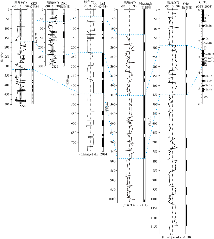
图 6 ZK3、ZK5钻孔的岩石地层、粒度、磁倾角、地磁极性序列及其与地磁极性年表(Cande and Kent, 1995; Gradstein and Ogg, 2004)的对比 Fig. 6 Lithology, sediment grain size, inclination, polarity stratigraphy of ZK3 and ZK5 boreholes and their correlation with the geomagnetic polarity time scale (Cande and Kent, 1995; Gradstein and Ogg, 2004) |
ZK3和ZK5孔的磁性地层学结果见图 6.其中ZK3孔的磁性地层共划分出17个极性段,包括9个正极性段(N1~N9)和8个负极性段(R1~R8).ZK5孔的磁性地层共划分出8个极性段,包括4个正极性段(N1~N4)和4个负极性段(R1~R4).
本次研究的两个钻孔处在库尔勒鼻状凸起上,两孔之间构造相对稳定,沉积物来源单一,沉积相对连续且稳定.因此,在不考虑极性时缺失的情况下,本次研究获得的极性统计结果与地磁极性年表(Cande and Kent, 1995;Gradstein and Ogg, 2004)约6 Ma以来的极性序列可依次较好对应(图 6).ZK3孔0~54.8 m深度区间由于岩性较粗,未能得到有效的古地磁结果,仅在底部54.8 m处得到一个正极性的样品,但是ZK3孔附近露头剖面0.3 m、0.5 m、0.7 m、1.8 m沉积物光释光年代测试结果分别为5.7±0.9 ka、6.2±1.4 ka、6.7±1.4 ka、7.4±1.0 ka,时代上均在全新世,说明这一段可能对应于布容(Brunhes)正极性时.54.8~167.0 m(R1)沉积物以负极性为主,在不考虑地层缺失的情况下,对应于松山(Matuyama)负极性时,由于此段出现大段的砂砾石层,未能获取有效的数据,因此未能揭示出Jaramillo、Olduvai和Reunion等正极性亚时.167.0~317.8 m(N2~N4)以正极性为主,可与高斯(Gauss)正极性时对应,其中,N2、N3和N4可分别与C2An.1n、C2An.2n和C2An.3n对应,R2和R3可与高斯正极性时中的凯纳(Kaena)和马莫斯(Mammoth)极性亚时对应.374.8~432.0 m对应吉尔伯特(Gilbert)负极性时,其中N5~N8可与柯奇蒂(Cochiti)、努尼瓦克(Nunivak)、西杜夫加尔(Sidufjall)、斯瓦拉(Thvera)等正极性亚时对应,N9顶部可以与C3An.1n结束时间6.0 Ma对应, 据R8段沉积速率外推,钻孔底部500 m处年龄约为6.2 Ma.
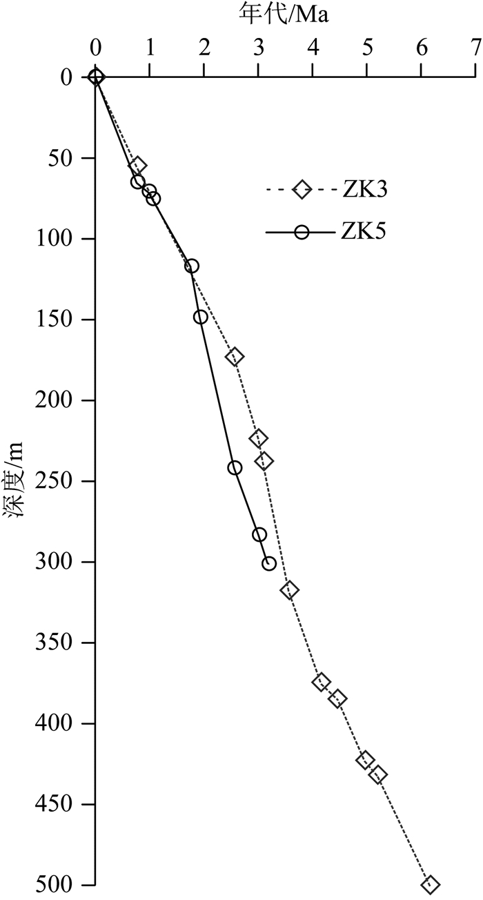
ZK5孔深度0~64.7 m区间以正极性为主,可对应于布容正极性时.64.7~241.5 m(R1~R3)对应于松山负极性时,其中,N2对应C1r.1n(Jaramillo)正极性亚时,N3对应C2n(Olduvai)正极性亚时.因未能获取有效数据,没能对比出C2r.1n(Reunion)正极性亚时.Olduvai正极性亚时的沉积物厚度较大,可能与河流发育有关(图 6).241.5~283.0 m(N4)以正极性为主,可与高斯正极性时中C2An.1n对应.据N4沉积速率外推,钻孔底部300 m处年龄约为3.2 Ma.通过年龄随深度的变化曲线可以看出(图 7),两个孔对应年代区间斜率变化较为一致,沉积环境较为稳定,说明本次划分的年代框架是合理的.

|
图 7 ZK3、ZK5钻孔年代随深度变化图 Fig. 7 Age-depth-accumulation relationships for the ZK3 and ZK5 borehole sedimentary sequences |
常宏等研究了塔里木盆地东南隆起带罗布泊凸起上的钻孔Ls1和Ls2,揭示出Ls1孔中松山/布容地磁极性倒转(M/B)界线在37.9 m、高斯/松山地磁极性倒转(Ga/M)界线在229.2 m、吉尔伯特/高斯地磁极性倒转(Gi/Ga)界线在442.6 m(图 8);Ls2孔M/B界线在36.7 m、Ga/M界线在224.6 m、Gi/Ga界线在439.4 m(Chang et al., 2012, 2014),与本次划分的地层年代界限基本相当.塔里木盆地中西部Mazatagh剖面的磁性地层研究结果表明(Sun et al., 2011),剖面的M/B界线在131.5 m、Ga/M界线在447.6 m、Gi/Ga界线在786.6 m(图 8).库车凹陷Yaha剖面的磁性地层研究结果表明(Huang et al., 2010),Ga/M界线在188.7 m、Gi/Ga界线在450.5 m(图 8),相同时段内Mazatagh剖面沉积厚度明显大于ZK3、ZK5和Ls1、Ls2孔,与塔里木盆地新生代以来的沉积特征较为吻合,中西部沉降速度快,沉积厚度大.上述研究结果进一步支撑了本次以古地磁为手段的ZK3和ZK5钻孔年代框架划分是可靠的.

|
图 8 ZK3、ZK5与Ls1钻孔(Chang et al., 2014)、Mazatagh剖面(Sun et al., 2011)、Yaha剖面(Huang et al., 2010)磁性地层结果对比 Fig. 8 Magnetostratigraphic correlation among the ZK3 and ZK5 borehole sequences, Ls1 boreholes (Chang et al., 2014), Mazatagh section (Sun et al., 2011) and Yaha section (Huang et al., 2010) |
因此,根据上述对比方案,ZK3孔中更新统底界(即M/B界线)为54.8 m,下更新统底界(即Ga/M界线)为167.0 m,上上新统底界(即Gi/Ga界线)在317.8 m,上新统底界为432.0 m,钻孔底部年龄约为6.2 Ma,属中新统上部.ZK5孔第四系中更新统底界(M/B界线)为64.7 m,下更新统底界(Ga/M界线)为241.5 m,钻孔底部年龄约为3.2 Ma,属上上新统.
4 ZK3、ZK5孔沉积速率变化指示的构造运动及沉积环境变迁特征对沉积物年代和沉积过程的研究,可以较好地认识构造-气候旋回对区域地质环境演化过程的影响.ZK3孔口高程为914.5 m,ZK5孔口高程为895.6 m,二者孔口高程相差18.9 m.两孔中更新统底界高程相差9.9 m,与现今的地面高差相当,下更新统底界相差74.5 m,说明库尔勒鼻状凸起发生了明显的掀斜作用,指示在第四纪之前构造运动活跃,同时也说明研究区沉积物变化主要受控于区域构造活动和气候变化(图 6).
通过ZK3孔年龄与沉积速率的关系研究发现在3.0—3.6 Ma出现沉积速率增大的现象,结合区域地质环境变化得出这次地质事件与天山山脉在此期间的快速隆升有关(图 9e),其动力机制可能来自上新世印度洋板块向欧亚板块深俯冲(Avouac et al., 1993).

|
图 9 中国东、西部若干地质剖面的沉积速率对比 Fig. 9 Comparison of the sediment accumulation rates for some typical geological sections in eastern and western China |
3.0—3.6 Ma发生的沉积速率增大的现象,本文将其主要归因于构造因素,因为这期间全球气候由暖湿向干冷转变(Zachos et al., 2008),东亚夏季风减弱,冬季风加强(An et al., 2001),中国西部气候处在温带草原和温带荒漠之间,降水相对较少(Xue et al., 2006; Sun et al., 2008).3.0—3.6 Ma沉积速率增大,颗粒由细逐渐变粗,指示了钻孔北部天山山脉在此期间发生了一次强烈隆升,源区剥蚀速率增大,造成下游物质接受区沉积速率增大.塔里木盆地东缘罗布泊剖面(图 9d)(常秋芳和常宏, 2013; Chang et al., 2014)、西缘喀什坳陷阿图什剖面(图 9c)(Heermance et al., 2007)、北缘库车坳陷库车塔吾剖面(图 9b)(Sun et al., 2009b),均在这一时期出现沉积速率增大的现象.张金起等(2009)在新疆准格尔盆地艾比湖东南缘、天山北侧,开展了K3钻孔(深500.8 m)的磁性地层研究(图 1),研究结果揭示早上新世约4.2—3.6 Ma期间,该地区主要以湖相沉积环境为主,3.6—3.0 Ma以来,随着青藏高原快速隆升,构造活动加强,湖相沉积环境逐渐消失,取而代之的是河流作用显著加强(图 9g).K3孔位于天山山脉的北侧,3.6—3.0 Ma以来的沉积速率增大,同样指示了天山在此期间的快速隆升.以上情况说明3.6—3.0 Ma构造运动在塔里木盆地内部具有准同期活动特征,指示天山山脉在此期间普遍隆升.
通过对西部青藏高原腹地的循化、贵德、临夏盆地,塔里木盆地东缘、西缘、北缘和东部华北平原黄骅坳陷内典型地质剖面沉积速率、沉积相演化与构造隆升耦合关系的对比分析(图 9),认为东西部地质剖面反映出大致在3.0—3.6 Ma出现沉积物的沉积相转变和沉积速率增大的现象,指示3.0—3.6 Ma之间发生了大规模区域构造活动(Heermance et al., 2007; 方小敏等, 2007; 张金起等, 2009; Sun et al., 2009b; 徐增连等, 2013; Chang et al., 2014; 肖国强等, 2014),构造活动使盆地周缘的山体隆升,导致盆-山地势高差加大,湖相沉积环境消亡,河流沉积体系发育.从构造活动的时间上看,这期区域性构造活动均与青藏高原强烈隆升有关,3.0—3.6 Ma期间构造运动在时间上与青藏高原北部发生强烈的隆升时间相吻合(张培震等, 2006).总之,高原隆升的辐射效应使得塔里木盆地周缘山体发生间歇性大规模隆升,主要动力还是印度洋板块向欧亚板块深俯冲.3.0—3.6 Ma期间山体隆升导致下游出现了沉积速率增大的情况,同时,晚新生代以来高原隆升和全球气候变冷使得塔里木盆地更加封闭,阻挡了来自海洋的湿润气流,进一步加剧塔里木盆地的干旱化程度.
5 结论通过详细的磁性地层学研究建立了塔里木盆地东北缘ZK3、ZK5钻孔地层年代框架,ZK3孔中更新统底界为54.8 m,下更新统底界为167.0 m,上上新统底界在317.8 m,上新统底界为432.0 m,钻孔底部年龄约为6.2 Ma,属上中新统上部.ZK5孔中更新统底界为64.7 m,下更新统底界为241.5 m,钻孔底部年龄约为3.2 Ma,属上上新统.
ZK3、ZK5孔沉积速率反映的构造活动特征表明在3.0—3.6 Ma之间沉积速率明显增大,颗粒由细变粗,反映了北部天山山脉在此期间的快速隆升.
通过东西部多个盆地典型地质剖面沉积速率、沉积演化与构造隆升耦合关系的对比分析,揭示3.0—3.6 Ma之间东西部均发生了准同期的区域性构造活动,盆地周边山体强烈隆升,盆地内部沉积速率增大.在时代上与上新世以来青藏高原快速隆升的时代一致,可能与青藏高原的扩展隆升效应有关,其动力可能来自上新世印度洋板块向欧亚板块的俯冲.
致谢 中国地质调查局天津地质调查中心李建芬参与了野外采样,古地磁实验在中国科学院地质与地球物理研究所古地磁与地质年代学实验室完成,两位审稿人、邓成龙研究员和李仕虎博士提出了宝贵的意见,在此一并表示诚挚谢意!
An Z S, Kutzbach J E, Prell W L, et al. 2001. Evolution of Asian monsoons and phased uplift of the Himalaya-Tibetan plateau since Late Miocene times. Nature, 411(6833): 62-66. DOI:10.1038/35075035 |
Arason P, Levi S. 2010. Maximum likelihood solution for inclination-only data in paleomagnetism. Geophysical Journal International, 182(2): 753-771. DOI:10.1111/(ISSN)1365-246X |
Avouac J P, Tapponnier P, Bai M, et al. 1993. Active thrusting and folding along the northern Tien Shan and Late Cenozoic rotation of the Tarim relative to Dzungaria and Kazakhstan. Journal of Geophysical Research:Solid Earth, 98(B4): 6755-6804. DOI:10.1029/92JB01963 |
Cande S C, Kent D V. 1995. Revised calibration of the geomagnetic polarity timescale for the late Cretaceous and Cenozoic. Journal of Geophysical Research, 100(B4): 6093-6095. DOI:10.1029/94JB03098 |
Chang H, An Z S, Liu W G, et al. 2012. Magnetostratigraphic and paleoenvironmental records for a Late Cenozoic sedimentary sequence drilled from Lop Nor in the eastern Tarim Basin. Global and Planetary Change, 80-81: 113-122. DOI:10.1016/j.gloplacha.2011.09.008 |
Chang H, An Z S, Liu W G, et al. 2014. Quaternary structural partitioning within the rigid Tarim plate inferred from magnetostratigraphy and sedimentation rate in the eastern Tarim Basin in China. Quaternary Research, 81(3): 424-432. DOI:10.1016/j.yqres.2013.10.018 |
Chang Q F, Chang H. 2013. The environmental magnetism study of core Ls2 in Lop Nur, Tarim since 7.1Ma. Quaternary Sciences (in Chinese), 33(5): 876-888. |
Charreau J, Gumiaux C, Avouac J P, et al. 2009. The Neogene Xiyu Formation, a diachronous prograding gravel wedge at front of the Tianshan:climatic and tectonic implications. Earth and Planetary Science Letters, 287(3-4): 298-310. DOI:10.1016/j.epsl.2009.07.035 |
Chen J, Heermance R V, Burbank D W, et al. 2007. Magnetochronology and its implications of the Xiyu conglomerate in the southwestern Chinese Tian Shan Foreland. Quaternary Sciences (in Chinese), 27(4): 576-587. |
Chung S L, Lo C H, Lee T Y, et al. 1998. Diachronous uplift of the Tibetan Plateau starting 40 Myr ago. Nature, 394(6695): 769-773. DOI:10.1038/29511 |
Clift P D, Blusztajn J, Nguyen A D. 2006. Large-scale drainage capture and surface uplift in Eastern Tibet-SW China before 24 Ma inferred from sediments of the Hanoi Basin, Vietnam. Geophysical Research Letters, 33(19): L19403. DOI:10.1029/2006GL027772 |
Coleman M, Hodges K. 1995. Evidence for Tibetan plateau uplift before 14 Myr ago from a new minimum age for east-west extension. Nature, 374(6517): 49-52. DOI:10.1038/374049a0 |
Deng C L, Wei Q, Zhu R X, et al. 2006. Magnetostratigraphic age of the Xiantai Paleolithic site in the Nihewan Basin and implications for early human colonization of Northeast Asia. Earth and Planetary Science Letters, 244(1-2): 336-348. DOI:10.1016/j.epsl.2006.02.001 |
Deng T, Wang S Q, Xie G P, et al. 2012. A mammalian fossil from the Dingqing Formation in the Lunpola Basin, northern Tibet, and its relevance to age and paleo-altimetry. Chinese Science Bulletin, 57(2-3): 261-269. DOI:10.1007/s11434-011-4773-8 |
Fang X M, Song C H, Dai S, et al. 2007. Cenozoic deformation and uplift of the NE Qinghai-Tibet Plateau:evidence from high-resolution magnetostratigraphy and basin evolution. Earth Science Frontiers (in Chinese), 14(1): 230-242. |
Gradstein F M, Ogg J G. 2004. Geologic Time Scale 2004-why, how, and where next!. Lethaia, 37(2): 175-181. DOI:10.1080/00241160410006483 |
Guo Z T, Ruddiman W F, Hao Q Z, et al. 2002. Onset of Asian desertification by 22 Myr ago inferred from loess deposits in China. Nature, 416(6877): 159-163. DOI:10.1038/416159a |
Heermance R V, Chen J, Burbank D W, et al. 2007. Chronology and tectonic controls of Late Tertiary deposition in the southwestern Tian Shan foreland, NW China. Basin Research, 19(4): 599-632. DOI:10.1111/bre.2007.19.issue-4 |
Huang B C, Piper J D A, Peng S T, et al. 2006. Magnetostratigraphic study of the Kuche Depression, Tarim Basin, and Cenozoic uplift of the Tian Shan Range, western China. Earth and Planetary Science Letters, 251(3-4): 346-364. DOI:10.1016/j.epsl.2006.09.020 |
Huang B C, Piper J D A, Qiao Q Q, et al. 2010. Magnetostratigraphic and rock magnetic study of the Neogene upper Yaha section, Kuche Depression (Tarim Basin):Implications to formation of the Xiyu conglomerate formation, NW China. Journal of Geophysical Research, 115(B1): B01101. DOI:10.1029/2008JB006175 |
Kirschvink J L. 1980. The least-squares line and plane and the analysis of palaeomagnetic data. Geophysical Journal of the Royal Astronomical Society, 62(3): 699-718. DOI:10.1111/gji.1980.62.issue-3 |
Li J J, Wen S X, Zhang Q S, et al. 1979. Exploration on the times, scales and forms of the Tibetan Plateau. Science in China (in Chinese), (6): 608-616. |
Li J J. 1999. Studies on the geomorphological evolution of the Qinghai-Xizang (Tibetan) Plateau and Asian monsoon. Marine Geology & Quaternary Geology (in Chinese), 19(1): 1-11. |
Li S H, Deng C L, Yao H T, et al. 2013. Magnetostratigraphy of the Dali Basin in Yunnan and implications for late Neogene rotation of the southeast margin of the Tibetan Plateau. Journal of Geophysical Research:Solid Earth, 118(3): 791-807. DOI:10.1002/jgrb.50129 |
Li Y J, Yang H J, Zhang G Y, et al. 2012. Redivision of the tectonic units of Tabei Rise in Tarim Basin, NW China. Acta Petrologica Sinica (in Chinese), 28(8): 2466-2478. |
Liu D L, Li H B, Sun Z M, et al. 2017. Cenozoic episodic uplift and kinematic evolution between the Pamir and Southwestern Tien Shan. Tectonophysics, 712-713: 438-454. DOI:10.1016/j.tecto.2017.06.009 |
Ma Q Y, Lü H T, Jiang H S, et al. 2015. A Division Program of Structural Units in the Paleozoic Platform-basin Region, Tarim Basin. Marine Origin Petroleum Geology (in Chinese), 20(1): 1-9. |
Métivier F, Gaudemer Y, Tapponnier P, et al. 1998. Northeastward growth of the Tibet Plateau deduced from balanced reconstruction of two depositional areas:The Qaidam and Hexi Corridor basins, China. Tectonics, 17(6): 823-842. DOI:10.1029/98TC02764 |
Rowley D B, Currie B S. 2006. Palaeo-altimetry of the late Eocene to Miocene Lunpola Basin, central Tibet. Nature, 439(7077): 677-681. DOI:10.1038/nature04506 |
Spicer R A, Harris N B W, Widdowson M, et al. 2003. Constant elevation of southern Tibet over the past 15 million years. Nature, 421(6923): 622-624. DOI:10.1038/nature01356 |
Sun D H, Bloemendal J, Yi Z Y, et al. 2011. Palaeomagnetic and palaeoenvironmental study of two parallel sections of late Cenozoic strata in the central Taklimakan Desert:Implications for the desertification of the Tarim Basin. Palaeogeography, Palaeoclimatology, Palaeoecology, 300(1-4): 1-10. DOI:10.1016/j.palaeo.2010.11.015 |
Sun J M, Zhu R X. 2006. Cenozoic deposits in the northern Tianshan Mountains and its implications for neotectonics and environmental changes. Quaternary Sciences (in Chinese), 26(1): 14-19. |
Sun J M, Zhang L Y, Deng C L, et al. 2008. Evidence for enhanced aridity in the Tarim Basin of China since 5.3 Ma. Quaternary Science Reviews, 27(9-10): 1012-1023. DOI:10.1016/j.quascirev.2008.01.011 |
Sun J M, Zhang Z Q, Zhang L Y. 2009a. New evidence on the age of the Taklimakan Desert. Geology, 37(2): 159-162. DOI:10.1130/G25338A.1 |
Sun J M, Li Y, Zhang Z Q, et al. 2009b. Magnetostratigraphic data on Neogene growth folding in the foreland basin of the southern Tianshan Mountains. Geology, 37(11): 1051-1054. DOI:10.1130/G30278A.1 |
Sun J M, Liu W G, Liu Z H, et al. 2017. Extreme aridification since the beginning of the Pliocene in the Tarim Basin, western China. Palaeogeography, Palaeoclimatology, Palaeoecology, 485: 189-200. DOI:10.1016/j.palaeo.2017.06.012 |
Wang C S, Zhao X X, Liu Z F, et al. 2008. Constraints on the early uplift history of the Tibetan Plateau. Proceedings of the National Academy of Sciences of the United States of America, 105(13): 4987-4992. DOI:10.1073/pnas.0703595105 |
Xiao G Q, Yang J L, Zhao C R, et al. 2014. Magnetostratigraphy of drill hole G2 in the Tianjin coastal area and its tectonic significance. Geological Bulletin of China (in Chinese), 33(10): 1642-1650. |
Xiao H, Ren Z L, Cui J P, et al. 2008. Relations between geothermal history and hydrocarbon Generation in Kongquehe Area. Journal of Northwest University (Natural Science Edition) (in Chinese), 38(4): 631-636. |
Xu Q M, Yuan G B, Yang J L, et al. 2017. Plio-Pleistocene magnetostratigraphy of northern Bohai Bay and its implications for tectonic events since ca. 2.0 Ma. Journal of Geodynamics, 111: 1-14. DOI:10.1016/j.jog.2017.08.002 |
Xu Z L, Luo M S, Zhang K X, et al. 2013. Cenozoic sedimentation rate of Xunhua, Linxia and Guide basins responding to the uplift of the Tibetan Plateau. Geological Bulletin of China (in Chinese), 31(1): 93-104. |
Xue X X, Zhang Y X, Yue L P. 2006. Paleoenvironments indicated by the fossil mammalian assemblages from red clay-loess sequence in the Chinese Loess Plateau since 8.0 Ma B.P. Science in China Series D, 49(5): 518-530. DOI:10.1007/s11430-006-0518-y |
Zachos J C, Dickens G R, Zeebe R E. 2008. An early Cenozoic perspective on greenhouse warming and carbon-cycle dynamics. Nature, 451(7176): 279-283. DOI:10.1038/nature06588 |
Zhang J Q, Liu B, Chen X G, et al. 2009. Environmental evolution at the drilling hole K3 in the east-south margin of Ebinur Lake, Xinjiang in Late Cenozoic. Geoscience (in Chinese), 23(6): 1012-1021. |
Zhang L Y, Ding L, Yang D, et al. 2012. Origin of middle Miocene leucogranites and rhyolites on the Tibetan Plateau:Constraints on the timing of crustal thickening and uplift of its northern boundary. Chinese Science Bulletin (in Chinese), 57(5): 511-524. DOI:10.1007/s11434-011-4813-4 |
Zhang P Z, Zheng D W, Yin G M, et al. 2006. Discussion on late Cenozoic growth and rise of northeastern margin of the Tibetan Plateau. Quaternary Sciences (in Chinese), 26(1): 5-13. |
Zheng H B, Powell C M, An Z S, et al. 2000. Pliocene uplift of the northern Tibetan Plateau. Geology, 28(8): 715-718. DOI:10.1130/0091-7613(2000)28<715:PUOTNT>2.0.CO;2 |
Zheng H B, Jia J T, Wang K. 2009. Cenozoic sedimentation in thesouthern Tarim Basin:Implications for the uplift of northern Tibet and evolution of the Taklimakan desert. Earth Science Frontiers (in Chinese), 16(6): 154-161. |
Zheng H B. 2016. Asia dust production ramped up since latest Oligocene driven by Tibetan Plateau uplift. National Science Review, 3(3): 271-274. DOI:10.1093/nsr/nww028 |
Zhu R X, Deng C L, Pan Y X. 2007. Magnetochronology of the fluvio-lacustrine sequences in the Nihewan basin and its implications for early human colonization of Northeast Asia. Quaternary Sciences (in Chinese), 27(6): 922-944. |
常秋芳, 常宏. 2013. 罗布泊Ls2孔近7.1Ma以来沉积物的环境磁学研究. 第四纪研究, 33(5): 876-888. DOI:10.3969/j.issn.1001-7410.2013.05.06 |
陈杰, Heermance R V, Burbank D W, 等. 2007. 中国西南天山西域砾岩的磁性地层年代与地质意义. 第四纪研究, 27(4): 576-587. DOI:10.3321/j.issn:1001-7410.2007.04.014 |
邓涛, 王世骐, 颉光普, 等. 2011. 藏北伦坡拉盆地丁青组哺乳动物化石对时代和古高度的指示. 科学通报, 56(34): 2873-2880. |
方小敏, 宋春晖, 戴霜, 等. 2007. 青藏高原东北部阶段性变形隆升:西宁、贵德盆地高精度磁性地层和盆地演化记录. 地学前缘, 14(1): 230-242. DOI:10.3321/j.issn:1005-2321.2007.01.022 |
李吉均, 文世宣, 张青松, 等. 1979. 青藏高原隆起的时代、幅度和形式的探讨. 中国科学, (6): 608-616. |
李吉均. 1999. 青藏高原的地貌演化与亚洲季风. 海洋地质与第四纪地质, 19(1): 1-11. |
李曰俊, 杨海军, 张光亚, 等. 2012. 重新划分塔里木盆地塔北隆起的次级构造单元. 岩石学报, 28(8): 2466-2478. |
马庆佑, 吕海涛, 蒋华山, 等. 2015. 塔里木盆地台盆区构造单元划分方案. 海相油气地质, 20(1): 1-9. DOI:10.3969/j.issn.1672-9854.2015.01.001 |
孙继敏, 朱日祥. 2006. 天山北麓晚新生代沉积及其新构造与古环境指示意义. 第四纪研究, 26(1): 14-19. DOI:10.3321/j.issn:1001-7410.2006.01.003 |
肖国强, 杨吉龙, 赵长荣, 等. 2014. 天津滨海地区G2孔磁性地层年代及其构造指示. 地质通报, 33(10): 1642-1650. DOI:10.3969/j.issn.1671-2552.2014.10.024 |
肖晖, 任战利, 崔军平, 等. 2008. 孔雀河地区热演化史与油气关系研究. 西北大学学报(自然科学版), 38(4): 631-636. |
徐增连, 骆满生, 张克信, 等. 2013. 青藏高原循化、临夏和贵德盆地新近纪沉积充填速率演化及其对构造隆升的响应. 地质通报, 31(1): 93-104. DOI:10.3969/j.issn.1671-2552.2013.01.009 |
张金起, 刘斌, 陈旭光, 等. 2009. 新疆艾比湖东南缘K3孔晚新生代环境演化. 现代地质, 23(6): 1012-1021. DOI:10.3969/j.issn.1000-8527.2009.06.003 |
张利云, 丁林, 杨迪, 等. 2012. 藏北中中新世淡色花岗岩及流纹岩的成因:对高原北部边界地壳加厚过程和隆升时代的制约. 科学通报, 57(2-3): 153-168. |
张培震, 郑德文, 尹功明, 等. 2006. 有关青藏高原东北缘晚新生代扩展与隆升的讨论. 第四纪研究, 26(1): 5-13. DOI:10.3321/j.issn:1001-7410.2006.01.002 |
郑洪波, 贾军涛, 王可. 2009. 塔里木盆地南缘新生代沉积:对青藏高原北缘隆升和塔克拉玛干沙漠演化的指示. 地学前缘, 16(6): 154-161. DOI:10.3321/j.issn:1005-2321.2009.06.017 |
朱日祥, 邓成龙, 潘永信. 2007. 泥河湾盆地磁性地层定年与早期人类演化. 第四纪研究, 27(6): 922-944. DOI:10.3321/j.issn:1001-7410.2007.06.008 |
 2018, Vol. 61

