 2017, Vol. 60


2. 中国科学院大学, 北京 100049;
3. 中国石油天然气股份有限公司华北油田分公司, 勘探开发研究院, 河北任丘 062552;
4. 中国科学院广州地球化学研究所, 同位素地球化学国家重点实验室, 广州 510640
2. University of Chinese Academy of Sciences, Beijing 100049, China;
3. Research Institute of Exploration and Development, PetroChina Huabei Oilfield Company, Hebei Renqiu 062552, China;
4. State Key Laboratory of Isotope Geochemistry, Guangzhou Institute of Geochemistry, Chinese Academy of Sciences, Guangzhou 510640, China
大火成岩省是指以短时间(一般小于几个百万年)、巨量喷发(覆盖面积通常大于105 km2)为特征的富镁铁质喷出岩和侵入岩所构成的大规模岩浆岩建造(Coffin and Eldholm, 1994; Bryan and Ernst, 2008).一般认为,如此短时的巨量基性岩浆喷发,与地幔柱作用有关(Ernst and Buchan, 2003; Campbell, 2005).大火成岩省是国际地学界的研究热点,涉及地球内部运行机制和过程、成矿作用和生物环境效应等多个地学前沿研究领域(Wignall, 2001; 徐义刚, 2002; Morgan et al., 2004; 徐义刚等, 2013a; Xu et al., 2014).
我国西南滇—川—黔地区,即扬子克拉通的西缘,地表出露大面积二叠纪玄武岩(如图 1所示),地质上命名为峨眉山大火成岩省(Emeishan Large Igneous Province,简称ELIP).它不仅是中国境内第一个获得国际学术界广泛认可的大火成岩省(徐义刚等, 2013b),也是全球范围内研究程度较高的大陆溢流玄武岩省之一(Bryan and Ferrari, 2013).前人根据沉积地层学揭示的下伏茅口灰岩的剥蚀程度(He et al., 2003),将峨眉山大火成岩省分为内带、中带和外带(如图 1所示),并提出了内带下方“地幔柱头熔融”成因模型(Chung and Jahn, 1995; Xu et al., 2001, 2004).究竟深部是否存在“地幔柱头熔融”模式所预示的古地幔柱作用遗迹,包括岩浆作用的具体位置和规模、组分特征与来源、深浅响应过程等,均有待深部地球物理探测结果的检验或约束(Coffin and Eldholm, 1994; Xu et al., 2007; Xu and He, 2007; 徐义刚等, 2007)为此,2010年11月至2013年4月,中国科学院地质与地球物理研究所在ELIP组织实施了人工地震测深、宽频带地震台阵探测、密集重力/地磁剖面测量等系列综合地球物理探测(陈赟等, 2017).该系列深部地球物理探测,是首次具体针对峨眉山大火成岩省形成机制而组织实施的综合地球物理剖面探测,为该区壳幔精细结构与深部过程研究提供了宝贵的、丰富的数据基础(Chen et al., 2015; 徐义刚等, 2017).

|
图 1 二叠纪峨眉山玄武岩分布及台站位置 绿色所示为晚二叠纪峨眉山玄武岩,红色三角形所示为COMPASS-ELIP剖面宽频带流动台站,蓝色三角形所示为本项研究用到的云南、四川区域地震台网的部分固定台站.蓝色虚线所示为二叠纪峨眉山玄武岩的下伏岩层—茅口组灰岩的差异剥蚀分界线(He et al., 2003).F1:怒江断裂;F2:澜沧江断裂;F3:哀牢山—红河断裂(ARF);F4:丽江—小金河断裂(LXF);F5:绿汁江—元谋断裂(LYF);F6:小江断裂(XJF);F7:师宗—弥勒断裂;F8:水城—紫云断裂(SZF);F9:遵义—贵阳断裂;F10:镇远—贵阳断裂. Fig. 1 Location map of the Late Permian Emeishan basalts and seismic stations used in this study The green blocks indicate the Late Permian Emeishan basalts. The red triangles indicate the digital broadband seismic stations of the COMPASS-ELIP experiment, and the blue triangles indicate the permanent stations of the Regional Digital Seismic Networks in Yunnan and Sichuan Provinces. The blue dashed lines indicate the boundaries of the differential erosional zones of Maokou limestone (He et al., 2003). F1: Nujiang fault; F2: Lancangjiang fault; F3: Ailaoshan—Red River fault (ARF); F4: Lijiang—Xiaojinhe fault (LXF); F5: Lvzhijiang—Yuanmou fault (LYF); F6: Xiaojiang fault (XJF); F7: Shizong—Mile fault; F8: Shuicheng—Ziyun fault (SZF); F9: Zunyi—Guiyang fault; F10: Zhengyuan—Guiyang fault. |
接收函数和面波成像是深部地震探测领域用于重建地球壳幔结构的基本方法.接收函数是求取台站下方介质对近垂直入射远震体波的脉冲响应的一种地震学方法(吴庆举等, 1998),因而具有对界面敏感、横向分辨高的优点.地震面波是由地震体波超临界反射并相互叠加后形成的、沿自由表面或界面传播的干涉型地震波(主要包括Rayleigh和Love两种基本类型)(Stein and Wysession, 2003).面波具有频散特性,即不同频率的面波,在沿界面横向传播的过程中,具有不同的穿透深度,具有对介质横波速度变化敏感、垂向分辨高的优点.无论是从传播方式,还是从生成机理角度,这两种方法具备相互结合、提高壳幔结构重建精度和可靠性的天然优势(Julià et al., 2000, 2009;胡家富等, 2005).自Shapiro和Campillo (2004)首次利用双台互相关方法,从环境噪声连续地震记录提取出Rayleigh面波以来,该方法快速得到普及,目前已经成为重建高分辨率地壳结构的主流方法之一.因此,接收函数和环境噪声面波联合反演对于重建地壳精细结构具有重要意义.
本文利用峨眉山大火成岩省宽频带地震台阵(COMPASS-ELIP)(Chen et al., 2015),以及位于廊带内的云南、四川区域地震台网的部分固定台站资料(如图 1所示),开展接收函数波形与环境噪声面波频散联合反演,重建COMPASS-ELIP剖面下方的地壳横波速度精细结构,为进一步确认与二叠纪古地幔柱作用有关的岩浆底侵的具体位置和规模提供横波速度结构特征方面的约束,并探讨峨眉山大火成岩省对青藏高原东南缘深部过程的影响.
2 数据与方法 2.1 基本数据COMPASS-ELIP剖面大致沿北纬27°东西向展布,西起滇西福贡,东至贵州贵定,横跨三江构造带和峨眉山大火成岩省的内带-中带-外带,全长约850 km.沿剖面布设了59个宽频带地震台站,采集器型号为Reftek-130,拾振计型号为CMG3-ESP(50 Hz~30 s/60 s),平均台间距约15 km.整个测线分两期布设:西线29个台站(E01-E31,其中E03、E04设计点位位于滇西怒山,因受地形阻隔最终放弃布设),观测时间从2010年11月至2011年11月;东线30个台站(E32-E61),观测时间从2011年12月至2013年04月(Chen et al., 2015).
此外,还收集了云南、四川区域地震台网所属的6个固定台站(GYA、HLI、LiJ、QiJ、SMK、YoS)2010年11月至2013年4月期间的连续波形记录(郑秀芬等, 2009).上述6个固定台站位于COMPASS-ELIP剖面所在廊带内,连续记录时间完全涵盖东、西两期观测,这些资料的加入,不仅进一步充实了可供利用的基础数据,更重要的是,为有效弥合由于西线、东线两期流动台阵资料观测时段不一致所导致的互相关计算及射线覆盖的分段性提供了有利条件.
2.2 Rayleigh波群速度频散基于环境噪声的面波成像方法不依赖于特定地震事件,目前已经成为获取地球不同尺度结构信息,尤其是高分辨率地壳结构的主流方法之一(Shapiro and Campillo, 2004; Shapiro et al., 2005; Yang et al., 2010; Yao et al., 2010; Badal et al., 2013).噪声源在均匀随机分布的条件下,将位置不同的两个台站记录的同一分量、同一时段连续地震记录,进行互相关计算,并将多个时段互相关计算的结果进行叠加,即可提取台站对之间地球介质的高信噪比面波经验格林函数(Empirical Green Functions,简称EGFs),进而通过提取面波频散进行高分辨率地壳结构成像研究(Shapiro et al., 2005; Bensen et al., 2007).
本文将COMPASS-ELIP实验的59个台站、邻近剖面的6个固定台站的垂直分量连续波形记录,逐台进行数据预处理,主要包括去线性趋势、去均值、去仪器响应、带通滤波、振幅归一化、谱白化等(Bensen et al., 2007).为了提高计算效率,重采样间隔为1s,截取时间长度为24h.针对预处理后的不同台站垂直分量资料,进行台站对之间的观测时段匹配,将匹配后的双台连续波形记录,进行互相关和叠加计算.理论上来说,在噪声源均匀随机分布的条件下,互相关函数的正负两支(物理可实现和非物理可实现信号)应该是对称的.但实际噪声源分布的不均匀性,会导致正负时间信号振幅的不对称,取正负半轴信号进行反序叠加作为台站对间的EGFs.图 2a为台站E25与其他台站的垂向分量连续记录,进行互相关和叠加计算得到的EGFs.基于多重窗时频分析方法(Dziewonski et al., 1969; Herrmann and Ammon, 2002)提取4~50 s周期范围内的基阶Rayleigh面波群速度频散曲线共826条,有效台间距范围为50~750 km.图 2b和c展示了台站对E01-E25的垂向分量EGF和相应的群速度频散测量实例.

|
图 2 (a)台站E25与其他台站垂向分量连续记录进行互相关和叠加计算得到的EGFs;(b)台站对E01-E25的垂向分量EGF;(c)台站对E01-E25的群速度频散测量示意图,台间距308 km,黑色方块所示为提取的基阶面波频散点 Fig. 2 (a) The stacked vertical-component EGFs with cross-correlation computations between the station pairs of E25 and the others; (b) The vertical-component EGF between station pair E01-E25; (c) Group dispersion measurements of station pair E01-E25, with an inter-station distance 308 km. The black blocks indicate the dispersions of fundamental mode waves |
图 3所示为各周期对应的有效射线路径数,可见在整个周期范围内射线数目较多,尤其是 < 30 s周期的射线路径条数超过600条,50 s周期仍可达到200多条.

|
图 3 各周期对应的有效射线路径数 Fig. 3 Ray-path numbers at each period |
为了评估提取的面波频散对应周期(4~50 s)在深度上的探测能力,基于研究区壳幔结构模型(平均莫霍面深度设为48 km(Chen et al., 2015),地壳速度参考CRUST1.0模型(Laske et al., 2013),上地幔速度参考AK135模型(Kennett et al., 1995),计算了相应的基阶Rayleigh面波群速度敏感核函数(图 4).可知,不同周期的Rayleigh面波对不同深度范围介质的S波速度结构敏感,周期越大,穿透深度越大.5~20 s周期的群速度主要受上地壳结构的影响,30~40 s周期的群速度主要受中、下地壳结构的影响,大于40 s周期的群速度则主要受到下地壳和上地幔顶部结构的影响.总体上,本文利用的群速度周期范围(4~50 s),已可以满足地壳结构重建的需求.

|
图 4 不同周期的Rayleigh面波群速度敏感核 Fig. 4 Group velocity sensitivity kernels of Rayleigh waves at different periods |
本文利用Ditmar和Yanovskaya(1987),Yanovskaya和Ditmar(1990)提出的面波层析成像方法进行分格频散反演.该方法是经典的Backus-Gilbert方法(Backus and Gilbert, 1968)在二维情况下的推广,是面波层析成像中广泛应用的方法之一.每个周期的群速度分布求解的目标函数可表达为:
|
(1) |
|
(2) |
|
(3) |
|
(4) |
|
(5) |
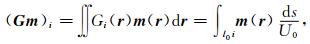
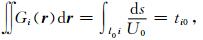
r=r(θ, φ)为位置矢量;U0为初始模型群速度;ti代表沿第i条路径的观测走时;ti0代表初始模型的计算走时;l0i代表第i条路径的长度;s代表参与反演的路径;α代表正则化参数,为权衡反演模型的光滑度和反演误差的折衷系数.经过多次测试,分格频散反演时的α取值为0.2,既保证了模型的光滑程度,也使误差较小.考虑到COMPASS-ELIP剖面沿经度方向展布,故仅沿经度方向进行网格划分,最终反演获得了横向尺度为0.3°的基阶Rayleigh面波群速度频散.
2.3 接收函数选取台站观测期间记录到的震中距在30°~ 90°范围内,震级大于MS5.0的有效远震事件961个(其中西线台阵记录到518个,东线台阵记录到443个),震中分布如图 5所示.采用时间域迭代反褶积算法(Ligorría and Ammon, 1999)计算接收函数,为了兼顾后续波形反演的分辨率和稳定性,给定高斯系数为2.0.最终获得直达P波和Pms转换波震相清晰的高信噪比接收函数6737个.

|
图 5 有效远震事件分布(黑色圆圈对应西线台阵记录到的事件;灰色圆圈对应东线台阵记录到的事件) Fig. 5 Distribution map of teleseismic events used in this study. The black circles indicate 518 events recorded by the stations of the West-Line array, and the gray circles indicate 443 events recorded by the stations of the East-Line array |
尽管接收函数和环境噪声面波频散联合反演,在重建地壳精细结构方面具备提高成像精度和可靠性的互补优势,但由于远震接收函数和面波频散在波的传播路径通道方面的差异,会存在信息来源、分辨尺度不匹配的问题.这一问题,在线性布设的剖面密集台阵资料中尤为突出.本文将从远震接收函数和环境噪声面波频散两类数据对应的介质响应空间位置和分辨尺度大小出发,进行信息来源和分辨尺度方面的协同处理.
3.1 接收函数与面波频散数据的匹配图 6a给出了基于IASP91模型(Kennett and Engdahl, 1991)计算得到的远震P波在Moho面形成的转换横波(Pms)的穿透点位置,其中,Moho面深度参考Chen(2015).为了获取台站下方及其周围一定空间范围内稳定可靠的、高信噪比平均接收函数,我们采用共Moho面转换点(CMCP)叠加方法(Deng et al., 2015),即选择以台站位置为中心,将Pms转换点位置位于某一尺度范围内的所有接收函数,逐一进行Pms转换波动校正后,按一定的权系数叠加,从而获得该台的平均接收函数.为了与Rayleigh面波频散的横向分格尺度匹配,本文所选取的叠加窗尺度为0.3°×0.3°;进一步将叠加窗划分为3×3个边长为0.1°的子网格,每个子网格给予不同的权重,如图 7a所示.

|
图 6 (a)远震P波在Moho面的转换横波(Pms)的转换点位置分布;(b)面波的有效射线覆盖(以15 s周期为例) 其中,三角所示为台站位置,叉号所示为转换点位置;黑色圆点所示为所在网格的频散中心点位置,实线所示为射线路径,网格所示为面波频散的分格尺度. Fig. 6 Distribution map of the Moho-converted points of Pms waves (a), and the ray-path coverage of the surface waves (b) Triangles indicate the stations, crosses indicate the Moho-converted points. Black dots indicate the average mid-point of all ray intercepts located within the grids, solid lines indicate the ray-paths of the surface wave, and grids indicate the tomographic grid-size of the surface wave dispersion, respectively. |

|
图 7 (a)接收函数CMCP叠加示意图;(b)面波频散加权叠加示意图 其中,三角所示为台站位置,RF11为Pms转换点位于编号11号子网格内的接收函数叠加后得到的平均接收函数,W11为编号11号子网格对应的权重;U1为1号网格频散,其所在位置对应网格内所有射线路径截距的平均中心点位置,L1为台站至平均中心点的距离.其他以此类推. Fig. 7 Schemes of the weighted stacking of receiver functions (a) and the dispersion (b) at a station Triangle indicates the station. RF11 indicates the average receiver function stacked by all the receiver functions that Moho-converted points located within the sub-grid 11, and W11 indicate the corresponding weight used in stacking. U1 indicates the dispersion and its location indicates the average mid-point of all ray intercepts located within the grid 1, L1 indicates the distance between station and the average mid-point U1. And so on for others. |
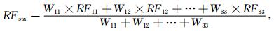
接收函数CMCP叠加分两步:首先,分别对动校正后的、Pms转换点位于各子网格内的接收函数进行平均,得到每个子网格对应的平均接收函数;然后,根据子网格所给权重,加权叠加所有子网格的平均接收函数,得到该台站的平均接收函数RFsta,即:
|
(6) |
其中,RF11, RF12, …, RF33分别表示9个子网格对应的平均接收函数,W11, W12, …, W33分别表示9个子网格对应的权重.依据Pms转换点到台站的水平距离范围,本文给定权重分别为:(1)W22=1;(2)W12=W21=W23=W32=1/2;(3)W11=W13=W31=W33=1/3.例如,据此计算得到的E28和E52台站所对应的接收函数如图 8b和e所示.

|
图 8 台站E28、E52的联合反演实例 (a)(d)蓝色虚线表示初始速度模型,红色实线为反演获得的S波速度结构;(b)(e)蓝线表示观测的接收函数,红线表示正演得到接收函数;(c)(f)黑色圆圈表示观测的面波频散,红线表示正演频散.Moho面深度参考接收函数H-κ叠加结果(Chen et al., 2015). Fig. 8 Examlpes of joint inversion for stations E28 and E52 The blue dashed lines in (a)(d) indicate the initial shear wave models and the red solid lines indicate the inversion results; the blue curves in (b)(e) indicate the observed receiver functions and the red curves indicate the predicted receiver functions; the black dots in (c)(f) indicate the observed Rayleigh wave dispersions and the red curves indicate the predicted Rayleigh wave dispersions. The Moho depths are after H-κ stacking results of receiver functions (Chen et al., 2015). |
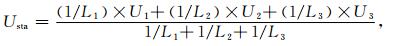
图 6b显示了COMPASS-ELIP台站和环境噪声面波的有效射线覆盖,以及由射线覆盖计算得到的网格频散中心点位置(所在网格内所有射线路径截距中点的平均值).如图 7b所示,某个台站所在位置的频散,可由台站所在网格及相邻网格的频散加权得到,即:
|
(7) |
其中,U1、U2、U3为网格频散,L1、L2、L3为台站到各网格频散中心点的距离.例如,由此计算得到E28、E52台站的频散曲线如图 8c和f所示.
基于每个台站的接收函数Pms转换点位置以及Rayleigh面波射线覆盖的实际情况,即可根据上述加权策略获得每个台站对应的平均接收函数和平均频散曲线,一方面既可有效提高接收函数波形和面波频散曲线的信噪比,更重要的是实现了联合反演中两套数据在信息来源和空间分辨尺度上的协同.沿COMPASS-ELIP剖面各台站的平均接收函数和平均频散分别如图 9a和b所示.
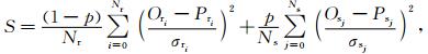
3.2 接收函数与面波频散联合反演本文利用接收函数波形和面波频散联合反演方法(Julià et al., 2000;Herrmann and Ammon, 2002),获得COMPASS-ELIP剖面地壳S波速度结构.构建的目标函数为:
|
(8) |
其中,Ori为ti时刻接收函数波形的实际观测振幅值,Pri为ti时刻接收函数波形的理论振幅值,σri为ti时刻接收函数的标准差;Osj为第j个周期面波频散的实际观测值,Psj为第j个周期的理论面波频散,σsj为第j个周期面波频散的标准差;Nr为接收函数波形的采样点数;Ns为面波频散的周期数;p为权重系数(0≤p≤1.0).当p=1.0时,退化为单一的面波频散反演;而当p=0时,则退化为单一的接收函数波形反演.
图 8给出了台站E28、E52的联合反演实例.现有研究结果表明(Julià et al., 2000, 2009),很大程度上得益于接收函数和面波频散信息的联合约束,本文所使用的联合反演方法对初始模型依赖较小.为此,给定初始模型为一维弹性半空间层状模型,共35层(如图 8a和d所示).初始模型P波速度设定为8.0 km·s-1,VP/VS设为1.75.密度参考经验公式ρ=0.77+0.32×VP(Birch, 1961).具体反演过程中,首先以面波频散为主(p=1.0) 迭代反演25次,获得一个光滑的背景速度结构,作为下一步联合反演的初始模型;然后,令p=0.6和0.4(增大接收函数波形约束的权重),分别迭代15次和20次,最终获得联合反演的最优解,其中,接收函数波形的拟合误差一般小于0.001,面波频散曲线的拟合误差一般小于0.01 km·s-1.可见,经历上述多次迭代反演之后,即可很好地同时拟合接收函数波形和面波频散曲线.图中Moho深度参考该台站的接收函数H-κ叠加结果(Chen et al., 2015).
4 S波速度结构通过接收函数与Rayleigh面波频散的联合反演,逐一获得COMPASS-ELIP剖面每个台站所在位置的一维S波速度结构;进而通过横向插值,最终获得剖面下方的二维地壳S波速度结构,如图 9c所示.成像结果所显示的主要特征如下:

|
图 9 (a) COMPASS-ELIP剖面各台站的平均接收函数;(b)平均频散;(c)联合反演获得的地壳S波速度结构;(d)人工地震测深揭示的地壳P波速度结构(徐涛等, 2015);(e)由联合反演结果计算得到的地壳平均S波速度(红线)和人工地震测深结果计算得到的地壳平均P波速度(蓝线)(徐涛等, 2015) 其中,HV所示为高速异常,LV1、LV2所示为低速异常;底侵界面UI和Moho面深度参考Chen et al.(2015).图件上方所示为沿剖面地形及台站位置分布. Fig. 9 Average receiver functions (a) and dispersions (b) at stations of the COMPASS-ELIP experiment. Crustal S-wave velocity (c) derived from the joint inversion of this study, and the crustal P-wave velocity (d) along the profile derived from the COMWIDE-ELIP experiment (Xu et al., 2015). (e) The average crustal S-wave velocity (red line) of this study and the average crustal P-wave velocity (blue line) from the COMWIDE-ELIP experiment (Xu et al., 2015) The underplating interface (UI) and Moho depth are after Chen et al. (2015). The elevation and the locations of the stations along the COMPASS-ELIP profile are shown in the uppermost panel. |
(1) 丽江—小金河断裂带(LXF)和水城—紫云断裂带(SZF)所在地域的浅部呈现明显的低速(VS < 3.2 km·s-1),意味着这些断裂带附近沉积层较厚(约10 km左右).丽江—小金河断裂带和水城—紫云断裂带两侧,中、上地壳(30 km以浅)存在明显的低速层(图 9c中LV1和LV2所示),尤其是位于中带东侧—外带西侧的中地壳低速层(LV2) 尤为明显.以上特征与接收函数波形(图 9a)、群速度分布(图 9b)特征等具有很好的对应性.
(2) 三江地区和内带中-下地壳分层明显(约30 km深度处),内带中、下地壳速度较高,且下地壳存在非常明显的高速异常(图 9c中HV所示,VS约3.8~4.2 km·s-1),顶界面深度约35 km,与接收函数CCP叠加剖面(Chen et al., 2015)所确定的底侵顶界面(UI)以及人工地震测深(徐涛等, 2015)揭示的下地壳高速异常(图 9d所示,VP约7.0~7.2 km·s-1)均具有很好的对应性.
(3) 外带和中带东侧上地幔顶部速度较其他区域略高(VS>4.3 km·s-1),此特征与人工源地震测深资料揭示的特征(图 9d)较为一致.
(4) 总体上,地壳平均S波速度(图 9e红线所示)沿剖面呈现出自西向东先增大后减小的分带性:三江构造带约3.5~3.6 km·s-1,内带约3.6~3.8 km·s-1,中带约3.5~3.6 km·s-1,外带约3.4~3.6 km·s-1,与地壳平均P波速度(图 9e蓝线所示)(徐涛等, 2015)的变化趋势较为一致.
5 讨论峨眉山大火成岩省位于青藏高原、扬子块体和印支块体的交汇和过渡部位(如图 1所示),是研究青藏高原东南缘不同块体相互作用和深部物质运动方式的关键地带(Chen et al., 2013).目前,有关该地区地壳结构方面的研究结果多数侧重于“地壳流”及其“通道”方面的讨论(Bai et al., 2010; Sun et al., 2012; Zhao et al., 2013; Chen et al., 2014; Liu et al., 2014; Bao et al., 2015; 郑晨等, 2016),较少关注到与峨眉山大火成岩省有关的深部结构特征及其对该地区深部过程的影响.本项研究具体针对峨眉山大火成岩省的深部结构特征,结合系列综合地球物理剖面探测结果,为多参数、多尺度地系统约束该区壳幔精细结构与深部过程提供了条件.
地表出露的大面积玄武岩是大规模岩浆作用最直观的表达,而地壳底部岩浆底侵(underplating)和随之发生的内侵(intraplating),则是岩浆喷发之前在地壳内部必经的物理-化学过程(Sun, 1989; Campbell and Griffiths, 1990; Rudnick, 1990; Fyfe, 1992; Cox, 1993; Xu et al., 2004),且这一过程必将对地壳的组分和结构带来重大改变,从而影响到地壳的物理性质.因此,确定底侵的具体位置和规模,不仅对于探测和鉴别古地幔柱作用遗迹本身具有重要意义,而且为探讨与底侵有关的岩浆作用过程提供了重要线索.本文研究结果所揭示的ELIP内带下地壳高速异常(VS约3.8~4.2 km·s-1)与接收函数成像、人工地震测深、布格重力异常分布特征及反演结果、波速比分布、大地热流分布、发震层分布等揭示的高波速、高波速比、高密度、高强度、低大地热流等特征均具有很好的一致性(Wu and Zhang et al., 2012; Deng et al., 2014, 2016; Chen et al., 2015; 徐涛等, 2015; 陈赟等, 2017).此外,邻近本文剖面位置的大地电磁测深和重力异常反演结果也揭示出内带存在明显的高电阻率、高密度区(程远志等, 2015; 申重阳等, 2015).上述多种地球物理探测结果获得的不同参数之间的高度“自洽”性(陈赟等, 2017),从二维剖面的角度一致地指示了与二叠纪地幔柱作用有关的岩浆“底侵”的具体位置和规模(内带下方,层厚15~20 km,横向尺度约180 km),为进一步探讨与岩浆底侵有关的深浅动力学过程提供了约束条件.
除内带的高速异常外,本项研究所揭示的另一显著特征,即丽江—小金河断裂带和水城—紫云断裂带两侧的中上地壳低速层(图 9c中LV1和LV2所示),此前该地区的多种地球物理研究结果对这一特征也均有不同程度地揭示(Yao et al., 2008; Bai et al., 2010; 吴建平等, 2013; 胥颐等, 2013;Zhao et al., 2013;Li et al., 2014; Sun et al., 2014; Bao et al., 2015),且多数结果将其解释为青藏高原“地壳流”东南向逃逸的通道(Bai et al., 2010; Zhao et al., 2013;Sun et al., 2014; Bao et al., 2015).综合本文和前人的研究结果来看,一方面,LV1和LV2所示的两个低速区应该确实存在;但另一方面,无论是从LV1和LV2所示低速区分布的深度范围(10~30 km)和规模,还是地震波低速的显著程度(VS约3.3 km·s-1,VP剖面上略有指示)来说,这两个低速区究竟是青藏高原中下地壳“地壳流”东南向逃逸的通道,还是所在区域深大断裂带的效应,抑或是所在地区地幔深部过程的浅部响应等,还非常值得商榷.为此,考察LV1和LV2所示的低速区与高原内部中下地壳低速层之间的连通性将显得非常重要.实际上,部分现有研究结果已清楚地显示,LV1和LV2所示的低速区与高原内部中下地壳低速层之间的连通性并不完好(Yao et al., 2008),特别是LV2,几乎是独立存在于滇中和滇东块体之间(Zhao et al., 2013;Li et al., 2014; 郑晨等, 2016).高精度定年研究结果表明,ELIP峰期年龄为259.1±0.5 Ma(Zhong et al., 2014),彼时扬子板块还位于赤道以南地区(Chen et al., 2015; 陈赟等, 2017).如此巨大的时-空变化,意味着ELIP峰期对应的大规模岩浆作用所引起的热效早已耗散殆尽.曾经历“底侵”和“内侵”等物理-化学过程的幔源岩浆,在地壳内部完全冷却后,将显著提高地壳的流变强度(Liu and Furlong, 1994)以及地壳内部不同深度层次的耦合程度,进而对来自青藏高原的“地壳流”产生强大的阻滞作用,导致滇中块体在西侧哀牢山—红河剪切带和东侧小江断裂带的协调下,以“构造逃逸”方式向东南挤出(Chen et al., 2013).因此,ELIP峰期对应的大规模岩浆作用,不仅改变了内带(滇中块体)的地壳结构、组分和性质,也对现今青藏高原东南缘的深部过程产生了深远影响.
6 结论本文利用峨眉山大火成岩省COMPASS-ELIP实验宽频带地震台阵,以及位于剖面廊带内的区域地震台网资料,在利用分格加权叠加策略实现接收函数和面波频散信息来源和分辨尺度协同的情况下,联合接收函数与Rayleigh面波频散资料,反演得到了横跨峨眉山大火成岩省及邻区关键剖面下方的地壳横波速度结构.研究结果显示:地壳平均S波速度沿剖面呈现自西向东先增大后减小的分带性,内带中、下地壳速度较高,尤其是下地壳存在明显的高速异常(VS约3.8~4.2 km·s-1);丽江—小金河断裂带和水城—紫云断裂带的东西两侧,中上地壳存在低速层(VS约3.3 km·s-1),尤其是水城—紫云断裂带东西两侧的中地壳低速层尤为明显.本文从横波速度结构特征的角度,进一步确认了峨眉山大火成岩省岩浆底侵的位置和规模,丰富了对古老重大地质事件大规模岩浆作用所引起的地球物理响应特征的认识,探讨了大规模岩浆作用对地壳性质的改造和对现今地球深部过程的影响.
致谢感谢中国地震局地球物理研究所国家数字测震台网数据备份中心(doi:10.11998/SeisDmc/SN)、云南、四川、贵州地震台网为本项研究提供了有关固定台站的连续波形数据.感谢三位匿名评审专家提供了宝贵的修改意见和建议,感谢编辑老师付出的辛苦劳动.
| Backus G E, Gilbert F. 1968. The resolving power of gross Earth data. Geophysical Journal International, 16(2): 169-205. DOI:10.1111/gji.1968.16.issue-2 | |
| Badal J, Chen Y, Chourak M, et al. 2013. S-wave velocity images of the Dead Sea Basin provided by ambient seismic noise. Journal of Asian Earth Sciences, 75: 26-35. DOI:10.1016/j.jseaes.2013.06.017 | |
| Bai D H, Unsworth M J, Meju M A, et al. 2010. Crustal deformation of the eastern Tibetan plateau revealed by magnetotelluric imaging. Nature Geoscience, 3(3): 358-362. | |
| Bao X W, Sun X X, Xu M J, et al. 2015. Two crustal low-velocity channels beneath SE Tibet revealed by joint inversion of Rayleigh wave dispersion and receiver functions. Earth and Planetary Science Letters, 415: 16-24. DOI:10.1016/j.epsl.2015.01.020 | |
| Bensen G D, Ritzwoller M H, Barmin M P, et al. 2007. Processing seismic ambient noise data to obtain reliable broad-band surface wave dispersion measurements. Geophysical Journal International, 169(3): 1239-1260. DOI:10.1111/gji.2007.169.issue-3 | |
| Birch F. 1961. The velocity of compressional waves in rocks to 10 kilobars.Part 2. Journal of Geophysical Research, 66(7): 2199-2224. DOI:10.1029/JZ066i007p02199 | |
| Bryan S, Ernst R E. 2008. Revised definition of Large Igneous Provinces (LIPs). Earth-Science Reviews, 86(1-4): 175-202. DOI:10.1016/j.earscirev.2007.08.008 | |
| Bryan S E, Ferrari L. 2013. Large igneous provinces and silicic large igneous provinces:Progress in our understanding over the last 25 years. Geological Society of America Bulletin, 125(7-8): 1053-1078. DOI:10.1130/B30820.1 | |
| Campbell I H. 2005. Large igneous provinces and the mantle plume hypothesis. Elements, 1(5): 265-269. DOI:10.2113/gselements.1.5.265 | |
| Campbell I H, Griffiths R W. 1990. Implications of mantle plume structure for the evolution of flood basalts. Earth and Planetary Science Letters, 99(1-2): 79-93. DOI:10.1016/0012-821X(90)90072-6 | |
| Chen M, Huang H, Yao H J, et al. 2014. Low wave speed zones in the crust beneath SE Tibet revealed by ambient noise adjoint tomography. Geophysical Research Letters, 41(2): 334-340. DOI:10.1002/2013GL058476 | |
| Chen Y, Wang Z H, Guo X, et al. 2017. Geophysical signature of the ancient mantle plume activities:a case study of the Emeishan Large Igneous Province. Bulletin of Mineralogy, Petrology and Geochemistry, 36(3): 394-403. DOI:10.3969/j.issn.1007-2802.2017.03.003 | |
| Chen Y, Xu Y G, Xu T, et al. 2015. Magmatic underplating and crustal growth in the Emeishan Large Igneous Province, SW China, revealed by a passive seismic experiment. Earth and Planetary Science Letters, 432: 103-114. DOI:10.1016/j.epsl.2015.09.048 | |
| Chen Y, Zhang Z J, Sun C Q, Badal J. 2013. Crustal anisotropy from Moho converted Ps wave splitting analysis and geodynamic implications beneath the eastern margin of Tibet and surrounding regions. Gondwana Research, 24(3-4): 946-957. DOI:10.1016/j.gr.2012.04.003 | |
| Cheng Y Z, Tang J, Chen X B, et al. 2015. Electrical structure and seismogenic environment along the border region of Yunnan, Sichuan and Guizhou in the south of the North-South seismic belt. Chinese Journal of Geophysics, 58(11): 3965-3981. DOI:10.6038/cjg20151107 | |
| Chung S L, Jahn B M. 1995. Plume-lithosphere interaction in generation of the Emeishan flood basalts at the Permian-Triassic boundary. Geology, 23(10): 889-892. DOI:10.1130/0091-7613(1995)023<0889:PLIIGO>2.3.CO;2 | |
| Coffin M F, Eldholm O. 1994. Large igneous provinces:crustal structure, dimensions, and external consequences. Reviews of Geophysics, 32(1): 1-36. DOI:10.1029/93RG02508 | |
| Cox K. 1993. Continental magmatic underplating.Philosophical Transactions of the Royal Society of London. Series A:Physical and Engineering Sciences, 342(1663): 155-166. DOI:10.1098/rsta.1993.0011 | |
| Deng Y F, Chen Y, Wang P, et al. 2016. Magmatic underplating beneath the Emeishan large igneous province (South China) revealed by the COMGRA-ELIP experiment. Tectonophysics, 672-673: 16-23. DOI:10.1016/j.tecto.2016.01.039 | |
| Deng Y F, Shen W S, Xu T, et al. 2015. Crustal layering in northeastern Tibet:a case study based on joint inversion of receiver functions and surface wave dispersion. Geophysical Journal International, 203(1): 692-706. DOI:10.1093/gji/ggv321 | |
| Deng Y F, Zhang Z J, Mooney W, et al. 2014. Mantle origin of the Emeishan large igneous province (South China) from the analysis of residual gravity anomalies. Lithos, 204: 4-13. DOI:10.1016/j.lithos.2014.02.008 | |
| Ditmar P G, Yanovskaya T B. 1987. A generalization of the Backus-Gilbert method for estimation of lateral variations of surface wave velocity. Izv. Phys. Solid Earth, 23: 470-477. | |
| Dziewonski A, Bloch S, Landisman M. 1969. A technique for the analysis of transient seismic signals. Bulletin of Seismological Society of America, 59(1): 427-444. | |
| Ernst R E, Buchan K L. 2003. Recognizing mantle plumes in the geological record. Annual Review of Earth and Planetary Sciences, 31(1): 469-523. DOI:10.1146/annurev.earth.31.100901.145500 | |
| Fyfe W S. 1992. Magma underplating of continental crust. Journal of Volcanology and Geothermal Research, 50(1-2): 33-40. DOI:10.1016/0377-0273(92)90035-C | |
| He B, Xu Y G, Chung S L, et al. 2003. Sedimentary evidence for a rapid, kilometer-scale crustal doming prior to the eruption of the Emeishan flood basalts. Earth and Planetary Science Letters, 213(3-4): 391-405. DOI:10.1016/S0012-821X(03)00323-6 | |
| Herrmann R, Ammon C. 2002. Surface Waves, Receiver Functions and Crustal Structure. Computer Programs in Seismology, Version 3.30. Saint Louis University. | |
| Hu J F, Zhu X G, Xia J Y, et al. 2005. Using surface wave and receiver function to jointly inverse the crust-mantle velocity structure in the West Yunnan area. Chinese Journal of Geophysics, 48(5): 1069-1076. DOI:10.3321/j.issn:0001-5733.2005.05.013 | |
| Julià J, Ammon C J, Herrmann R B, et al. 2000. Joint inversion of receiver function and surface wave dispersion observations. Geophysical Journal International, 143(1): 99-112. DOI:10.1046/j.1365-246x.2000.00217.x | |
| Julià J, Jagadeesh S, Rai S S, et al. 2009. Deep crustal structure of the Indian shield from joint inversion of P wave receiver functions and Rayleigh wave group velocities:Implications for Precambrian crustal evolution. Journal of Geophysical Research, 114(B10): B10313. DOI:10.1029/2008JB006261 | |
| Kennett B L N, Engdahl E R. 1991. Traveltimes for global earthquake location and phase identification. Geophysical Journal International, 105(2): 429-465. DOI:10.1111/gji.1991.105.issue-2 | |
| Kennett B L N, Engdahl E R, Buland R. 1995. Constraints on seismic velocities in the Earth from traveltimes. Geopysical Journal Interantional, 122(1): 108-124. | |
| Laske G, Masters G, Ma Z T, et al. 2013. Update on CRUST1.0-A 1-degree global model of Earth's crust.//EGU General Assembly 2013. Vienna, Austria:EGU, EGU2013-2658. | |
| Li Y H, Pan J T, Wu Q J, et al. 2014. Crustal and uppermost mantle structure of SE Tibetan plateau from Rayleigh-wave group-velocity measurements. Earthquake Science, 27(4): 411-419. DOI:10.1007/s11589-014-0090-z | |
| Ligorría J P, Ammon C J. 1999. Iterative deconvolution and receiver-function estimation. Bulletin of the Seismological Society of America, 89(5): 1395-1400. | |
| Liu M, Furlong K P. 1994. Intrusion and underplating of mafic magmas:thermal-rheological effects and implications for Tertiary tectonomagmatism in the North American Cordillera. Tectonophysics, 237(3-4): 175-187. DOI:10.1016/0040-1951(94)90253-4 | |
| Liu Q Y, Van Der Hilst R D, Li Y, et al. 2014. Eastward expansion of the Tibetan Plateau by crustal flow and strain partitioning across faults. Nature Geoscience, 7(5): 361-365. DOI:10.1038/ngeo2130 | |
| Morgan J P, Reston T J, Ranero C R. 2004. Contemporaneous mass extinctions, continental flood basalts, and'impact signals':are mantle plume-induced lithospheric gas explosions the causal link. Earth and Planetary Science Letters, 217(3-4): 263-284. DOI:10.1016/S0012-821X(03)00602-2 | |
| Rudnick R. 1990. Growing from below. Nature, 347(6295): 711-712. DOI:10.1038/347711a0 | |
| Shapiro N M, Campillo M. 2004. Emergence of broadband Rayleigh waves from correlations of the ambient seismic noise. Geophysical Research Letters, 31(7): L07614. | |
| Shapiro N M, Campillo M, Stehly L, et al. 2005. High-resolution surface-wave tomography from ambient seismic noise. Science, 307(5715): 1615-1618. DOI:10.1126/science.1108339 | |
| Shen C Y, Yang G L, Tan H B, et al. 2015. Gravity anomalies and crustal density structure characteristics of profile Weixi-Guiyang. Chinese Journal of Geophysics, 58(11): 3952-3964. DOI:10.6038/cjg20151106 | |
| Stein S, Wysession M. 2003. An Introduction to Seismology, Earthquakes and Earth Structure. Oxford, UK: Blackwell Publishing. | |
| Sun S S. 1989. Growth of lithospheric mantle. Nature, 340(6234): 509-510. DOI:10.1038/340509a0 | |
| Sun X X, Bao X W, Xu M J, et al. 2014. Crustal structure beneath SE Tibet from joint analysis of receiver functions and Rayleigh wave dispersion. Geophysical Research Letters, 41(5): 1479-1484. DOI:10.1002/2014GL059269 | |
| Sun Y, Niu F L, Liu H F, et al. 2012. Crustal structure and deformation of the SE Tibetan plateau revealed by receiver function data. Earth and Planetary Science Letters, 349-350: 186-197. DOI:10.1016/j.epsl.2012.07.007 | |
| Wignall P B. 2001. Large igneous provinces and mass extinctions. Earth-Science Reviews, 53(1-2): 1-33. DOI:10.1016/S0012-8252(00)00037-4 | |
| Wu J, Zhang Z J. 2012. Spatial distribution of seismic layer, crustal thickness, and VP/VS ratio in the Permian Emeishan Mantle Plume region. Gondwana Research, 22(1): 127-139. DOI:10.1016/j.gr.2011.10.007 | |
| Wu J P, Yang T, Wang W L, et al. 2013. Three dimensional P-wave velocity structure around Xiaojiang fault system and its tectonic implications. Chinese Journal of Geophysics, 56(7): 2257-2267. DOI:10.6038/cjg20130713 | |
| Wu Q J, Zeng R S. 1998. The crustal structure of Qinghai-Xizang Plateau inferred from broadband teleseismic waveform. Acta Geophysica Sinica, 41(5): 669-679. | |
| Xu T, Zhang Z J, Liu B F, et al. 2015. Crustal velocity structure in the Emeishan large igneous province and evidence of the Permian mantle plume activity. Science China Earth Sciences, 58(7): 1133-1147. DOI:10.1007/s11430-015-5094-6 | |
| Xu Y, Yang X T, Liu J H. 2013. Tomographic study of crustal velocity structures in the Yunnan region southwest China. Chinese Journal of Geophysics, 56(6): 1904-1914. DOI:10.6038/cjg20130613 | |
| Xu Y G. 2002. Mantle plumes, large igneous provinces and their geologic consequences. Earth Science Frontiers, 9(4): 341-353. | |
| Xu Y G, Chung S L, Jahn B M, et al. 2001. Petrologic and geochemical constraints on the petrogenesis of Permian-Triassic Emeishan flood basalts in southwestern China. Lithos, 58(3-4): 145-168. DOI:10.1016/S0024-4937(01)00055-X | |
| Xu Y G, He B. 2007. Thick and high velocity crust in Emeishan large igneousprovince, SW China:Evidence for crustal growth by magmatic underplating/intraplating. In:Foulger G, Jurdy D, eds. The Origins of melting anomalies. Plates, plumes, and planetary processes. Geological Society of America Special Papers, 430:841-858. | |
| Xu Y G, He B, Chung S L, et al. 2004. Geologic, geochemical, and geophysical consequences of plume involvement in the Emeishan flood-basalt province. Geology, 32(10): 917-920. DOI:10.1130/G20602.1 | |
| Xu Y G, He B, Huang X L, et al. 2007. Identification of mantle plumes in the Emeishan Large Igneous Province. Episodes, 30(1): 32-42. | |
| Xu Y G, He B, Huang X L, et al. 2007. The debate over mantle plumes and how to test the plume hypothesis. Earth Science Frontiers, 14(2): 1-9. DOI:10.1016/S1872-5791(07)60011-6 | |
| Xu Y G, He B, Luo Z Y, et al. 2013b. Study on mantle plume and large igneous provinces in China:an overview and perspectives. Bulletin of Mineralogy, Petrology and Geochemistry, 32(1): 25-39. | |
| Xu Y G, Wang C Y, Shen S Z. 2014. Permian large igneous provinces:Characteristics, mineralization and paleo-environment effects. Lithos, 204: 1-3. DOI:10.1016/j.lithos.2014.06.003 | |
| Xu Y G, Wang Y, Wei X, et al. 2013a. Mantle plume-related mineralization and their principal controlling factors. Acta Petrologica Sinica, 29(10): 3307-3322. | |
| Xu Y G, Zhong Y T, Wei X, et al. 2017. Permian mantle plumes and Earth's surface system evolution. Bulletin of Mineralogy, Petrology and Geochemistry, 36(3): 359-373. | |
| Yang Y J, Zheng Y, Chen J, et al. 2010. Rayleigh wave phase velocity maps of Tibet and the surrounding regions from ambient seismic noise tomography. Geochemistry, Geophysics, Geosystems, 11(8): Q0801. | |
| Yanovskaya T B, Ditmar P G. 1990. Smoothness criteria in surface wave tomography. Geophysical Journal International, 102(1): 63-72. DOI:10.1111/gji.1990.102.issue-1 | |
| Yao H J, Beghein C, Van Der Hilst R D. 2008. Surface wave array tomography in SE Tibet from ambient seismic noise and two-station analysis-Ⅱ.Crustal and upper-mantle structure. Geophysical Journal International, 173(1): 205-219. DOI:10.1111/gji.2008.173.issue-1 | |
| Yao H J, Van Der Hilst R D, Montagner J. 2010. Heterogeneity and anisotropy of the lithosphere of SE Tibet from surface wave array tomography. Journal of Geophysical Research:Solid Earth, 115(B12): B12307. DOI:10.1029/2009JB007142 | |
| Zhao L F, Xie X B, He J K, et al. 2013. Crustal flow pattern beneath the Tibetan Plateau constrained by regional Lg-wave Q tomography. Earth and Planetary Science Letters, 383: 113-122. DOI:10.1016/j.epsl.2013.09.038 | |
| Zheng C, Ding Z F, Song X D. 2016. Joint inversion of surface wave dispersion and receiver functions for crustal and uppermost mantle structure in Southeast Tibetan Plateau. Chinese Journal of Geophysics, 59(9): 3223-3236. DOI:10.6038/cjg20160908 | |
| Zheng X F, Ouyang B, Zhang D N, et al. 2009. Technical system construction of Data Backup Centre for China Seismograph Network and the data support to researches on the Wenchuan earthquake. Chinese J. Geophys. (in Chinese), 52(5): 1412-1417. DOI:10.3969/j.issn.0001-5733.2009.05.031 | |
| Zhong Y T, He B, Mundil R, et al. 2014. CA-TIMS zircon U-Pb dating of felsic ignimbrite from the Binchuan section:Implications for the termination age of Emeishan large igneous province. Lithos, 204: 14-19. DOI:10.1016/j.lithos.2014.03.005 | |
| 陈赟, 王振华, 郭希, 等. 2017. 古地幔柱作用"遗迹"的深部地球物理探测——以峨眉山大火成岩省为例. 矿物岩石地球化学通报, 36(3): 394–403. DOI:10.3969/j.issn.1007-2802.2017.03.003 | |
| 程远志, 汤吉, 陈小斌, 等. 2015. 南北地震带南段川滇黔接壤区电性结构特征和孕震环境. 地球物理学报, 58(11): 3965–3981. DOI:10.6038/cjg20151107 | |
| 胡家富, 朱雄关, 夏静瑜, 等. 2005. 利用面波和接收函数联合反演滇西地区壳幔速度结构. 地球物理学报, 48(5): 1069–1076. DOI:10.3321/j.issn:0001-5733.2005.05.013 | |
| 申重阳, 杨光亮, 谈洪波, 等. 2015. 维西-贵阳剖面重力异常与地壳密度结构特征. 地球物理学报, 58(11): 3952–3964. DOI:10.6038/cjg20151106 | |
| 吴建平, 杨婷, 王未来, 等. 2013. 小江断裂带周边地区三维P波速度结构及其构造意义. 地球物理学报, 56(7): 2257–2267. DOI:10.6038/cjg20130713 | |
| 吴庆举, 曾融生. 1998. 用宽频带远震接收函数研究青藏高原的地壳结构. 地球物理学报, 41(5): 669–679. | |
| 徐涛, 张忠杰, 刘宝峰, 等. 2015. 峨眉山大火成岩省地壳速度结构与古地幔柱活动遗迹:来自丽江-清镇宽角地震资料的约束. 中国科学:地球科学, 45(5): 561–576. | |
| 胥颐, 杨晓涛, 刘建华. 2013. 云南地区地壳速度结构的层析成像研究. 地球物理学报, 56(6): 1904–1914. DOI:10.6038/cjg20130613 | |
| 徐义刚. 2002. 地幔柱构造、大火成岩省及其地质效应. 地学前缘, 9(4): 341–353. | |
| 徐义刚, 何斌, 黄小龙, 等. 2007. 地幔柱大辩论及如何验证地幔柱假说. 地学前缘, 14(2): 1–9. | |
| 徐义刚, 何斌, 罗震宇, 等. 2013b. 我国大火成岩省和地幔柱研究进展与展望. 矿物岩石地球化学通报, 32(1): 25–39. | |
| 徐义刚, 王焰, 位荀, 等. 2013a. 与地幔柱有关的成矿作用及其主控因素. 岩石学报, 29(10): 3307–3322. | |
| 徐义刚, 钟玉婷, 位荀, 等. 2017. 二叠纪地幔柱与地表系统演变. 矿物岩石地球化学通报, 36(3): 359–373. | |
| 郑晨, 丁志峰, 宋晓东. 2016. 利用面波频散与接收函数联合反演青藏高原东南缘地壳上地幔速度结构. 地球物理学报, 59(9): 3223–3236. DOI:10.6038/cjg20160908 | |
| 郑秀芬, 欧阳飚, 张东宁, 等. 2009. "国家数字测震台网数据备份中心"技术系统建设及其对汶川大地震研究的数据支撑. 地球物理学报, 52(5): 1412–1417. DOI:10.3969/j.issn.0001-5733.2009.05.031 | |