 2017, Vol. 60

2. 中山大学地球科学和地质工程学院, 广州 510275;
3. 中国国土资源航空物探遥感中心, 北京 100083;
4. 中国地震局地球物理勘探中心, 郑州 450002;
5. 中国石油勘探开发研究院西北分院, 兰州 730020
 , GAO Rui1,2, LU Zhan-Wu1, LI Wen-Hui1, GUO Hua3, XIONG Xiao-Song1, FENG Shao-Ying4, LI Hong-Qiang1, ZHAO Yu-Lian5
2. School of Earth Science and Geological Engineering, Sun Yat-sen University, Guangzhou 510275, China;
3. China Aero Geophysical Survey & Remote Sensing Center for Land and Resources, Beijing 100083, China;
4. The Geophysical Exploration Center, China Earthquake Administration, Zhengzhou 450002, China;
5. PetroChina Exploration & Development Research Institute (Northwest), Lanzhou 730020, China
四川盆地地处扬子板块西缘,是发育在青藏高原东部最重要的压性盆地之一,位于古亚洲、环太平洋与特提斯三大构造域的结合部位,是由盆地周边的褶皱带和断裂围限起来的一个大型构造沉积盆地(毛琼等,2006;张岳桥等,2011;郑荣才等,2012).盆地与其周缘的龙门山、米仓山—大巴山、七曜山和大楼山及大凉山形成了典型的盆山体系,他们之间存在多期多样的构造转换过程和复合联合关系(Jia et al., 2010; 刘树根等, 2011; Liu et al., 2012; 郑荣才等, 2012).盆山耦合研究逐步成为当前大陆动力学研究的热点和前沿领域(刘树根等, 2003; 张国伟等, 2006; 李德威等, 2009),盆山结构和耦合关系的不同类型对盆地内油气的分布有较大的控制作用.本文对已有3段深地震反射数据进行拼接联线处理,获得跨越四川盆地的330 km的成果剖面(图 1),并结合其他地质地球物理资料,对四川盆地的地壳结构和变形进行研究,为后续研究盆山深部构造关系对盆地影响提供依据.

|
图 1 深地震反射剖面位置图 黑色实线:深地震反射剖面;红点:CMP位置;红色数字:CMP号;黑色方框:井位. Fig. 1 Location map of the deep seismic reflection profile Black line:deep seismic reflection profile; red point: CMP location; Red numbers:Common midpoints numbers; Black box:location of nearby wells. |
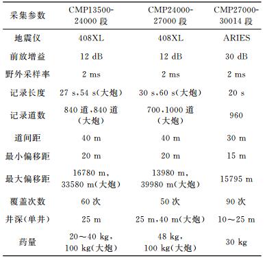
2008—2010年分3段完成穿过四川盆地的深地震反射剖面数据采集工作,剖面总长约330 km,穿过四川盆地和华蓥山褶皱带(图 1).为获得浅、中、深资料,野外采用不同药量的炸药震源进行激发,具体采集参数见表 1.
|
|
表 1 深地震反射剖面数据采集参数 Table 1 Data acquisition parameters of deep seismic reflection profiles |
为揭示四川盆地深部地壳结构,我们对3段深地震反射剖面进行了拼接联线处理.本次处理采用CGG、OMEGA和GRISYS多个处理软件相结合的手段,在详细分析原始资料的基础上,对处理方法和参数进行了大量的测试工作,确定了处理流程,其中关键处理技术包括数据整合、静校正、一致性处理和叠前去噪等.
2.2.1 数据拼接整合技术对3段地震数据(图 1),进行叠前拼接处理,不仅可以提高资料的叠加次数,也可以把拼接后的数据作为一个整体来进行数据处理,以保证拼接资料的波组特征、频率、相位等的整体性和一致性.原始数据的道间距、炮间距、记录长度、覆盖次数、接收道数和激发药量等采集参数不同,因此如何既可以使不同品质的数据无痕地拼接在一起又能真实可靠地反映地下的地质构造,其关键是如何消除因不同施工年代、不同施工参数和不同基准面等因素所造成的地震资料差异.叠前数据拼接整合包括观测系统整合和原始数据体的拼接整合.
2.2.2 一致性处理完成数据拼接后,利用子波整形及地表一致性处理,进一步调整3段原始资料因仪器型号、施工参数及激发条件等引起的子波和相位不一致的问题.
(1) 振幅补偿
纵向上,地震波传播过程中由于大地吸收衰减和波前扩散作用,使得地震资料的振幅和频率衰减较快,尤其中深层信息丢失严重.横向上,因激发和接收点近地表结构的差异,造成数据在炮与炮之间、炮内道与道之间的能量差异较大(仲伯军和印兴耀, 2008;陈新荣等, 2009; 吕亚亮, 2015).通过球面扩散补偿和地表一致性振幅补偿两方法相结合可以补偿地震波传播过程中在时间和空间上的振幅和能量的衰减,消除纵向上和横向上的能量不均衡问题(图 2).

|
图 2 振幅补偿前(a)、后(b)单炮记录 Fig. 2 Shot gathers before (a) and after (b) the surface consistent amplitude processing |
(2) 子波一致性处理
由于3段剖面采集时间、激发接收条件和仪器设备等多方面因素的不同,导致原始数据存在子波振幅、频率、相位等方面存在明显差异.这些差异,对于炮集而言主要表现在向下传播的波前上,对检波点来说主要表现在向上传播的波前上,对于共炮检距集而言包含对入射角、反射角以及射线轨迹的影响,这些影响会造成信号产生畸变(邬达理等, 2001; 王西文和周立宏, 2002;云美厚等,2006).通过地震子波整形可消除这种畸变,为后续处理的剩余静校正和速度分析打下良好基础.
2.2.3 叠前去噪由于本区复杂的地表和地下地质条件,以及地震野外激发、接收、检波器组合、外部环境噪音(如风吹草动、动物或人走动等)等因素,造成原始数据发育各种噪音,如随机噪声、面波、猝发脉冲以及50 Hz工业电干扰等,影响了原始资料的品质.强噪音会覆盖有效波,弱噪音会藏匿于地震记录中,不论噪音强与弱都会或多或少地影响地震资料的信噪比,从而影响处理效果(冯晓辉和陈怡斌, 2012),因此必须做好叠前去噪工作.根据不同的噪音形成机制、特性,选择不同的去噪方法来压制干扰波突出有效波,从而提高地震资料的信噪比和分辨率.具体做法如下:
(1) 面波去除 面波是普遍存在的能量很强的低频规则干扰,其穿透深度与频率有关,随着深度加深,低频成分增多,视速度较低,在炮集上呈线性分布(李文杰等, 2008; 陈文超等, 2009).根据面波与有效波视速度、能量及频率范围等方面的差异,采用自适应衰减面波的方法,取得了较好效果.
(2) 线性干扰滤除 线性干扰在叠前道集上出现多个视倾角,且视速度低能量强,甚至完全淹没有效波,对成像影响较大.根据干扰波与反射波的差异,在T-X域采用倾斜叠加和向前、向后线性预测的方法确定干扰波的视速度、分布范围及规律,并将识别出的线性干扰从原始数据中减去(陈兴盛等, 2000).
(3) 高能干扰波的分频压制 原始记录中存在声波、尖脉冲、方波、野值等一些强能量干扰,严重影响剖面的信噪比.高能干扰的分频压制技术是根据“多道识别单道去噪”的思想,根据不同频段干扰波的特点不同,采用分频的方式在不同频带内自动识别出强干扰,确定噪音的空间位置,根据定义的门槛值和衰减系数,采用时变、空变的方式进行压制.
(4) 随机噪音衰减 随机噪音是由于数据采集过程中地表微震、风吹草动、人畜走动、炮点激发和仪器接收等因素造成的不规则干扰.该噪音没有固定的视速度和传播方向,且振幅、频率和分布等也无规律可循,混合在有效波中难以消除(Ristau and Wooil, 2001; 胡天跃, 2002; 杨德宽等, 2000).时间-空间域随机噪音衰减技术是通过对噪声进行频谱分析,并确定噪声的频率范围,然后在限定的频带内根据振幅的统计规律识别并剔除异常振幅值,有效地压制噪声(郭树祥等, 2006).
经过上述去噪处理,去除了大部分的干扰波,突出了有效信号,去噪前后对比见图 3.

|
图 3 叠前去噪前(a)、后(b)单炮对比 Fig. 3 Shot gathers before (a) and after (b) pre-stack denoising |
DMO校正技术是叠前部分偏移,是将动校正后的数据偏移到记录倾斜反射界面零炮检距道的位置上,同时消除地表和各个反射层倾角的影响,使叠加道集中反射面元内的各反射点收敛到同一个反射点上,实现了共反射点叠加,改善了成像效果(酆少英等,2015;王津等,2016).DMO叠加有以下几个特点:1) 可以使平层、倾斜层同时得到加强;2) 改进了叠加速度对倾角的依赖性,使速度谱的精度得到提高;3) 该方法是一种多道运算的部分偏移过程,具有一定的压制随机噪音的作用.图 4显示对于本次地震数据来说,DMO技术对于华蓥山褶皱带区域成像效果较为明显.

|
图 4 常规动校正叠加(a)与DMO叠加(b)剖面对比 Fig. 4 Stack sections of NMO (a) and DMO (b) |
对深地震反射剖面成果剖面进行了自动识别处理(李文辉等, 2012),获得了类线条图剖面,为后续的构造解释提供了构造格架图像(图 5a).

|
图 5 深地震反射剖面 (a)偏移剖面;(b)构造解释. Fig. 5 Deep seismic reflection profile (a) Migration section; (b) Structural interpretation. |
根据图 5展示的反射特征,认为0~6.0 s为上地壳,主要出现多套近平的连续的强反射波组,为典型的沉积层的反射特征.在剖面西北端龙门山前沉积层达到最厚,厚度超过15 km,向东南方向逐渐变薄到~8 km.从CMP26500开始,向东南方向,沉积层发生强烈的褶皱变形,最厚约7 km,最薄仅约5 km,形成华蓥山薄皮褶皱冲断带.
3.2 中下地壳沉积层与莫霍面之间为中下地壳,反射特征横向变化明显:CMP 13500-CMP 18500段剖面的反射系数相对较小,反射同相轴较少,CMP 18500-CMP26500段剖面,中下地壳具有较强的反射波组,表现为近平的或弧形反射特征;CMP26500-CMP30000段剖面,在中下地壳有反射同相轴存在,地震波的振幅相对较小,但其下面的莫霍面反射较清晰,该种清晰且连续的莫霍面反射说明不是因为地震波能量不足引起的中下地壳反射较弱,而应该是华蓥山褶皱冲断带的复杂构造引起的.中下地壳反射系数的横向变化意味着在四川盆地的深部是各向异性的.
3.3 莫霍面与地幔反射剖面上最显著的反射层出现在15 s(45 km,CMP22000下方)至14 s(42 km,CMP30000之下),表现为近平的可断续追踪的反射特征.以该反射层为界,上下反射特征明显不同:其上存在相对复杂的反射同相轴,反射强弱不同,连续性不同;其下表现为相对透明的反射特征,几乎无反射同相轴.这一明显差异为莫霍反射面所特有,也即壳幔边界(Cook et al., 2010).根据深反射剖面得到的四川盆地地壳厚度约40~45 km,与四川盆地内的接收函数结果一致(He et al., 2014).
横向上莫霍面反射特征不同:在四川盆地东部,莫霍面反射表现为连续的近平的清晰的强反射特征;而在四川盆地西部(CMP13500-23000),存在断续的莫霍面反射,且如上所述,中下地壳反射率相对较低,因此这种弱反射可能是由于地震波经过巨厚的沉积层被吸收衰减而使有效信号能量减弱,也可能表明下地壳或上地幔的物性横向变化导致反射系数较小;在四川盆地西部——华蓥山褶皱带(CMP22500-30000段),莫霍面反射出现在~14 s,埋深~42 km,表现为近平的连续的强反射特征.
剖面上(图 5)另一最显著特征是东南倾向的反射同相轴从约双程走时13 s(埋深约40 km,在CMP 18500之下)向下延伸至18 s(55 km,CMP 24000之下),即从下地壳穿透至上地幔,埋深约35~55 km.在国外深地震反射剖面上也发现过类似的地幔反射,特别是来自欧洲和加拿大的深反射剖面(图 6).例如在苏格兰(Flack et al., 1990; Flack and Warner, 1990; Morgan et al., 1994; Smythe et al., 1982; Warner et al., 1996; Warner and McGeary, 1987)、波罗的海(BABEL Working Group, 1990; Balling, 2000)、北海(Reston,1990b)、加拿大(Calvert et al., 1995; Cook et al., 1999; Van Der Velden and Cook, 2005)和比利牛斯山脉(Choukroune, 1989; Suriñach et al., 1993)均被报道过类似的地幔反射特征.

|
图 6 国外深地震反射剖面揭示的古俯冲实例 (a)英国BIRPS计划在苏格兰北部完成的GRID11剖面揭示的前加里东期古俯冲(Flack et al, 1990); (b) BABEL项目在欧洲西北部完成的剖面揭示的早元古代古俯冲(Balling, 2000); (c) LITHOPROBE计划在加拿大西北部揭示的早元古代古俯冲(Cook et al., 1999); (d) LITHOPROBE计划在加拿大东部揭示的太古代的古俯冲(Calvert et al., 1995). Fig. 6 Examples for fossil subduction revealed by international deep seismic reflection profiles (a) Migrated section GRID 11 profile from BIRPS program in north of Scotland (Flack et al, 1990), proposed fossil subduction age: Pre-Caledonian; (b) Migrated profiles 3 and 4 of the BABEL project (Balling, 2000), proposed fossil subduction age: Early Proterozoic; (c) Migrated LITHOPROBE profile across northwest Canada(Cook et al., 1999), only part is shown, proposed fossil subduction age: Early Proterozoic; (d) Migrated LITHOPROBE profile 48 across eastern Canadian Precambrian terranes (Calvert et al., 1995), proposed fossil subduction age: Archean. All seismic sections shown at approximate 1:1 vertical-horizontal scale. |
深地震反射剖面显示,以CMP26500为界,西东两侧中下地壳反射特征不同,分别表现为弧形和断续的平的反射特征,说明四川盆地中下地壳构造变形不同,并非同一刚性块体.熊小松等人(2015)对四川盆地布格重力异常剥离沉积盖层和莫霍面起伏引起的重力异常研究,获得了反映中下地壳因壳内密度不均引起的重力异常特征,发现四川盆地东西陆块中下地壳存在结构差异;根据已有的四川盆地基底顶界面等值线图(Zhou et al., 2006; Xiong et al., 2015),发现四川盆地存在东西两个沉积中心;航磁异常结果(图 7)显示四川盆地表现为北东向展布的宽缓正磁异常夹弱的负磁异常,在华蓥山(位置约在CMP2700) 西北侧为强航磁异常区,华蓥山褶皱带为弱磁异常区,该航磁异常特征表明四川盆地基底并非统一(谷志东和汪泽成, 2014).综上述资料推测,扬子克拉通在太古宙—古元古代可能存在东西两个陆核.

|
图 7 航磁异常图(黑实线-深地震反射剖面;数字-CMP号) Fig. 7 Aeromagnetic anomaly map (black line-deep seismic reflection section; numbers-CMP) |
康义昌(1986)和Korsch等的钻孔资料和研究结果(康义昌, 1986; Korsch et al., 1991)认为四川盆地最老的沉积盖层为中震旦系(新元古代晚期:680~540 Ma).近年来,张健等(2012)利用钻孔资料恢复该区最古老沉积地层应属于680~630 Ma的陡山沱组群.康义昌(1986)和张健等(2012)认为在震旦系沉积地层之下可能还存在更古老的地层,厚达数千米.
在四川盆地内石油勘探的多个钻井中,只有威28井、威117井与女基井对盆地基底进行了钻井取心(井位置见图 1).罗志立(1986)对威28井和女基井的岩心进行地球化学特征分析得出花岗岩基底年龄均属于新元古代:威28井获得的花岗岩年龄为740.99 Ma;女基井获得的花岗岩年龄为701.54 Ma.谷志东等(2014)利用威远地区威117井得到的花岗岩年龄为794±11 Ma,也属于新元古代,该年龄与近年来公开报道的四川盆地周缘的花岗岩体结晶年龄具有一致性.利用地球化学的结果提出的扬子克拉通演化过程,其中一个观点认为,825~740 Ma为华南地区岩浆活动时间,该活动与岛弧和造山作用有关,是海洋岩石圈俯冲作用的结果(Zhou et al., 2002);又或与后造山期板片撕裂作用有关(Wang et al., 2006).
在四川盆地沉积层之下东南向的反射同相轴,在地幔反射部分表现为明显的15°倾角的反射特征(假设地幔VP=8 km·s-1).该反射波组可能代表了沿扬子板块西北缘新元古代古俯冲的遗迹(Zhou et al., 2002, 2006),该种解释对扬子克拉通演化提供了重要的新的约束.四川盆地西缘出露的最早期沉积岩和火成岩以及剖面显示的盆地内连续的未变形的反射层,为岩石圈形变年龄提供了年龄下限,至少是~830 Ma(Li et al., 2003; Zhou et al., 2002),应该也是该地区可识别的最后一个主要热构造事件.否则,任何早期构造伸展事件都会使四川盆地东南倾向的反射波组发生严重变形、破坏甚至是消失.然而,这些深部事件链接到地表上相关地壳岩层边界并不简单.目前,在地震剖面上没有迹象显示四川盆地东南向的反射波组向西是如何延伸到上覆地壳的(图 5b).实际上这种古俯冲可能是沿地壳底部来自于很远处,我们在成都以东约100 km处发现了地幔反射,而Zhou等(2002)提出了俯冲板片将火山弧带到成都以西几百公里的地方.像这么远距离的俯冲,应该是低角度俯冲,类似于前人提出的印度板块和青藏高原之间的陆陆碰撞俯冲的几何结构(Hauck et al., 1998; Nelson et al., 1996).
5 结论(1) 针对研究区地表地形条件和地下地质构造不同的特点,对不同施工单位采用不同仪器设备和采集参数获得的3段深地震反射数据进行拼接联线处理,采用的关键处理方法和参数合理,提高了资料信噪比和分辨率,为后续的构造解释提供了可靠的成果剖面.
(2) 深地震反射剖面揭示出四川盆地地壳上地幔细结构:0~6 s的上地壳以沉积层为主,在剖面西北端龙门山前达到最厚,厚度超过15 km,从西北向东南逐渐变薄,在东南端华蓥山下达到最薄,约8 km,且沉积层发生强烈的褶皱变形,形成华蓥山薄皮褶皱冲断带;莫霍面出现在13~15 s之间,埋深约40~45 km,西北段断续出现,东南段可连续追踪.
(3) 另一最突出反射特征是在沉积层之下从下地壳延伸至地幔的东南向倾斜反射层,从约13 s向下延伸至约18 s,这些地幔反射的几何特征与国外一些深反射剖面揭示的古俯冲残片非常相似.结合四川盆地及其周边地区其他地球物理和地球化学花岗岩同位素年龄等资料,我们认为这些倾斜反射波组是扬子克拉通地台西北缘新元古代俯冲的遗迹.
| BABEL Working Group. 1990. Evidence for early Proterozoic plate tectonics from seismic reflection profiles in the Baltic shield. Nature, 348(6296): 34-38. DOI:10.1038/348034a0 | |
| Balling N. 2000. Deep seismic reflection evidence for ancient subduction and collision zones within the continental lithosphere of northwestern Europe. Tectonophysics, 329(1-4): 269-300. DOI:10.1016/S0040-1951(00)00199-2 | |
| Calvert A J, Sawyer E W, Davis W J, et al. 1995. Archaean subduction inferred from seismic images of a mantle suture in the Superior Province. Nature, 375(6533): 670-674. DOI:10.1038/375670a0 | |
| Chen W C, Gao J H, Bao Q Z. 2009. Adaptive attenuation of ground roll via continuous wavelet transform. Chinese Journal of Geophysics, 52(11): 2854-2861. | |
| Chen X R, Shang X M, Li J G, et al. 2009. Analysis on influence factors of preserved amplitude processing. Progress in Geophysics, 24(4): 1411-1419. DOI:10.3969/j.issn.1004-2903.2009.04.032 | |
| Chen X S, Zhou J J, Chen X. 2000. Application of prestack noise elimination to seismic data processing in Turpan-Hami Basin. Xinjiang Petroleum Geology, 21(4): 292-293, 346. | |
| Choukroune P. 1989. The ECORS Pyrenean deep seismic profile reflection data and the overall structure of an orogenic belt. Tectonics, 8(1): 23-39. DOI:10.1029/TC008i001p00023 | |
| Cook F A, Van Der Velden A J, Hall K W, et al. 1999. Frozen subduction in Canada's Northwest Territories: Lithoprobe deep lithospheric reflection profiling of the western Canadian Shield. Tectonics, 18(1): 1-24. DOI:10.1029/1998TC900016 | |
| Cook F A, White D J, Jones A G, et al. 2010. How the crust meets the mantle: Lithoprobe perspectives on the Mohoroviičć discontinuity and crustmantle transition. Canadian Journal of Earth Sciences, 47(4): 315-351. DOI:10.1139/E09-076 | |
| Feng S Y, Liu B J, Ji J F, et al. 2015. The survey on fine lithospheric structure beneath Hohhot-Baotou basin by deep seismic reflection profile. Chinese Journal of Geophysics, 58(4): 1158-1168. DOI:10.6038/cjg20150406 | |
| Feng X H, Chen Y B. 2012. Application of combined de-noising to Seismic-data processing in Dongling area. Natural Gas Technology and Economy, 6(1): 33-36. | |
| Flack C, Warner M. 1990. Three-dimensional mapping of seismic reflections from the crust and upper mantle, northwest of Scotland. Tectonophysics, 173(1-4): 469-481. DOI:10.1016/0040-1951(90)90239-5 | |
| Flack C A, Klemperer S L, McGeary S E, et al. 1990. Reflections from mantle fault zones around the British Isles. Geology, 18(6): 528-532. DOI:10.1130/0091-7613(1990)018<0528:RFMFZA>2.3.CO;2 | |
| Gu Z D, Zhang W, Yuan M. 2014. Zircon SHRIMP U-Pb dating of basal granite and its geological significance in Weiyuan area of Sichuan basin. Chinese Journal of Geology, 49(1): 202-213. | |
| Gu Z D, Wang Z C. 2014. The discovery of Neoproterozoic extensional structures and its significance for gas exploration in the Central Sichuan Block, Sichuan basin, South China. Science China: Earth Sciences, 57(11): 2758-2768. DOI:10.1007/s11430-014-4961-x | |
| Guo S X, Wang L X, Han W G. 2006. Analysis on optimization processing method of prestack data. Geophysical Prospecting for Petroleum, 45(5): 497-502. | |
| Hauck M L, Nelson K D, Brown L D, et al. 1998. Crustal structure of the Himalayan orogen at ~90° east longitude from Project INDEPTH deep reflection profiles. Tectonics, 17(4): 481-500. DOI:10.1029/98TC01314 | |
| He R Z, Shang X F, Yu C Q, et al. 2014. A unified map of Moho depth and Vp/Vs ratio of continental China by receiver function analysis. Geophysical Journal International, 199(3): 1910-1918. DOI:10.1093/gji/ggu365 | |
| Hu T Y. 2002. The current situation and future of seismic data prestack noise attenuation techniques. Progress in Geophysics, 17(2): 218-223. DOI:10.3969/j.issn.1004-2903.2002.02.005 | |
| Jia D, Li Y Q, Lin A M, et al. 2010. Structural model of 2008 M7.9 Wenchuan earthquake in the rejuvenated Longmen Shan thrust belt, China. Tectonophysics, 491(1-4): 174-184. DOI:10.1016/j.tecto.2009.08.040 | |
| Kang Y C. 1986. The basement structure of Sichuan Basin and its relationship to the overlying sequences. Petroleum Geology & Experiment, 8(3): 235-302. | |
| Korsch R J, Mai H Z, Sun Z C, et al. 1991. The Sichuan basin, southwest China: a Late Proterozoic (Sinian) petroleum province. Precambrian Research, 54(1): 45-63. DOI:10.1016/0301-9268(91)90068-L | |
| Li D W. 2003. A new model for uplifting mechanism of Qinghai-Tibet Plateau. Earth Science—Journal of China University of Geosciences, 28(6): 593-600. | |
| Li W H, Gao R, Wang H Y, et al. 2012. Research on structure information recognition of deep seismic reflection profiles. Chinese Journal of Geophysics, 55(12): 4138-4146. DOI:10.6038/j.issn.0001-5733.2012.12.026 | |
| Li W J, Wei X C, Ning J R, et al. 2008. A method for suppressing surface wave by considering the characteristic of frequency attenuation. Geophysical Prospecting for Petroleum, 47(3): 225-227. | |
| Li X H, Li Z X, Zhou H W, et al. 2003. SHRIMP U-Pb zircon age, geochemistry and Nd isotope of the Guandaoshan pluton in SW Sichuan: petrogenesis and tectonic significance. Science in China Series D: Earth Science, 46(S1): 73-83. | |
| Liu S G, Xu G S, Li J C, et al. 2003. A study on the dynamics of mountain-building, basin-formation and natural gas pool formation in the system of Longmen Mountains and west Sichuan foreland basin, China. Journal of Chengdu University of Technology (Science & Technology Edition), 20(6): 559-566. | |
| Liu S G, Deng B, Li Z W, et al. 2011. The texture of sedimentary basin-orogenic belt system and its influence on oil/gas distribution: A case study from Sichuan basin. Acta Petrologica Sinica, 27(3): 621-635. | |
| Liu S G, Deng B, Li Z W, et al. 2012. Architecture of basin-mountain systems and their influences on gas distribution:A case study from the Sichuan basin, South China. Journal of Asian Earth Science, 47: 204-215. DOI:10.1016/j.jseaes.2011.10.012 | |
| Luo Z L. 1986. Is there a paleocontinental neucleus in central Sichuan. Journal of Chengdu college of Geology, 13(3): 65-73. | |
| Mao Q, Zou G F, Zhang H M, et al. 2006. Discussion on geodynamic evolution and oil/gas prospect of the Sichuan basin. Natural Gas Industry, 26(11): 7-168. | |
| Morgan J V, Hadwin M, Warner M R, et al. 1994. The polarity of deep seismic reflections from the lithospheric mantle: evidence for a relict subduction zone. Tectonophysics, 232(1-4): 319-328. DOI:10.1016/0040-1951(94)90093-0 | |
| Nelson K D, Zhao W J, Brown L D, et al. 1996. Partially molten middle crust beneath southern Tibet: synthesis of project INDEPTH results. Science, 274(5293): 1684-1688. DOI:10.1126/science.274.5293.1684 | |
| Reston T J. 1990b. Mantle shear zones and the evolution of the northern North Sea basin. Geology, 18(3): 272-275. DOI:10.1130/0091-7613(1990)018<0272:MSZATE>2.3.CO;2 | |
| Ristau J P, Wooil M M. 2001. Adaptive filtering of random noise in 2-D geophysical data. Geophysics, 66(1): 342-349. DOI:10.1190/1.1444913 | |
| Smythe D K, Dobinson A, McQuillin R, et al. 1982. Deep structure of the Scottish Caledonides revealed by the MOIST reflection profile. Nature, 299(5881): 338-340. DOI:10.1038/299338a0 | |
| Suriñach E, Marthelot J M, Gallart J, et al. 1993. Seismic images and evolution of the Iberian crust in the Pyrenees. Tectonophysics, 221(1): 67-80. DOI:10.1016/0040-1951(93)90028-I | |
| Van Der Velden A J, Cook F A. 2005. Relict subduction zones in Canada. Journal of Geophysical Research: Solid Earth, 110(B8): B08403. DOI:10.1029/2004JB003333 | |
| Wang X L, Zhou J C, Qiu J S, et al. 2006. LA-ICP-MS U-Pb zircon geochronology of the Neoproterozoic igneous rocks from Northern Guangxi, South China: Implications for tectonic evolution. Precambrian Research, 145(1-2): 111-130. DOI:10.1016/j.precamres.2005.11.014 | |
| Wang X W, Zhou L H. 2002. Wavelet transform used in the concatenation of 3-D seismic data sets. Geophysical Prospecting for Petroleum, 41(4): 448-451. | |
| Warner M, McGeary S. 1987. Seismic reflection coefficients from mantle fault zones. Geophysical Journal International, 89(1): 223-230. DOI:10.1111/gji.1987.89.issue-1 | |
| Warner M, Morgan J, Barton P, et al. 1996. Seismic reflections from the mantle represent relict subduction zones within the continental lithosphere. Geology, 24(1): 39-42. DOI:10.1130/0091-7613(1996)024<0039:SRFTMR>2.3.CO;2 | |
| Wu D L, Zheng W J, Jin X L, et al. 2001. Unified seismic data processing of multiple 3D surveys and case study. Geophysical Prospecting for Petroleum, 40(1): 9-19. | |
| Xiong X S, Gao R, Guo L H, et al. 2015. The deep structure feature of the Sichuan Basin and adjacent orogens. Acta Geologica Sinica (English Edition), 89(4): 1153-1164. DOI:10.1111/acgs.2015.89.issue-4 | |
| Xiong X S, Gao R, Zhang J S, et al. 2015. Differences of structure in mid-lower crust between the eastern and western blocks of the Sichuan basin. Chinese Journal of Geophysics, 58(7): 2413-2423. DOI:10.6038/cjg20150718 | |
| Yang D K, Zheng Z J, Hu L X, et al. 2000. Some cognitions on random noise in deep-layer seismic exploration. Geophysical Prospecting for Petroleum, 39(3): 50-61, 72. | |
| Yun M H, Ding W, Wang K Y, et al. 2006. Study and primary application on consistency processing of seismic data. Geophysical Prospecting for Petroleum, 45(1): 65-69. | |
| Zhang J, Shen P, Yang W, et al. 2012. New understandings of Pre-Sinian sedimentary rocks in the Sichuan Basin and the significance of oil and gas exploration there. Natural Gas Industry, 32(7): 1-5. | |
| Zhang G W, Guo A L, Yao M A. 2006. Considerations on the basic study of Chinese continental geology and tectonics. Progress in Natural Science, 16(10): 1210-1215. | |
| Zhang Y Q, Dong S W, Li J H, et al. 2011. Mesozoic multi-directional compressional tectonics and formation-reformation of Sichuan basin. Geology in China, 38(2): 233-250. | |
| Zheng G C, Li G H, Dai C C, et al. 2012. Basin-mountain coupling system and its sedimentary response in Sichuan analogous foreland basin. Atca Geologica Sinica, 86(1): 170-180. | |
| Zhong B J, Yin X Y. 2008. Consistent processing technology for splicing 3-D seismic data in complex area. Geophysical Prospecting for Petroleum, 47(4): 393-397. | |
| Zhou M F, Yan D P, Kennedy A K, et al. 2002. SHRIMP U-Pb zircon geochronological and geochemical evidence for Neoproterozoic arc-magmatism along the western margin of the Yangtze Block, South China. Earth and Planetary Science Letters, 196(1-2): 51-67. DOI:10.1016/S0012-821X(01)00595-7 | |
| Zhou M F, Ma Y, Yan D P, et al. 2006. The Yanbian Terrane (Southern Sichuan Province, SW China): a neoproterozoic arc assemblage in the western margin of the Yangtze Block. Precambrian Research, 144(1-2): 19-38. DOI:10.1016/j.precamres.2005.11.002 | |
| 陈文超, 高静怀, 包乾宗. 2009. 基于连续小波变换的自适应面波压制方法. 地球物理学报, 52(11): 2854–2861. DOI:10.3969/j.issn.0001-5733.2009.11.020 | |
| 陈新荣, 尚新民, 李继光, 等. 2009. 地震资料振幅保持影响因素分析. 地球物理学进展, 24(4): 1411–1419. DOI:10.3969/j.issn.1004-2903.2009.04.032 | |
| 陈兴盛, 周建军, 陈新. 2000. 叠前去噪方法在吐哈盆地地震资料处理中的应用. 新疆石油地质, 21(4): 292–293, 346. | |
| 酆少英, 刘保金, 姬计法, 等. 2015. 呼和浩特—包头盆地岩石圈细结构的深地震反射探测. 地球物理学报, 58(4): 1158–1168. DOI:10.6038/cjg20150406 | |
| 冯晓辉, 陈怡斌. 2012. 组合去噪在东岭地区资料处理中的应用. 天然气技术与经济, 6(1): 33–36. | |
| 谷志东, 汪泽成. 2014. 四川盆地川中地块新元古代伸展构造的发现及其在天然气勘探中的意义. 中国科学D辑:地球科学, 44(10): 2210–2220. | |
| 谷志东, 张维, 袁苗. 2014. 四川盆地威远地区基底花岗岩锆石SHRIMP U-Pb定年及其地质意义. 地质科学, 49(1): 202–213. | |
| 郭树祥, 王立歆, 韩文功. 2006. 叠前地震数据优化处理技术分析. 石油物探, 45(5): 497–502. | |
| 胡天跃. 2002. 地震资料叠前去噪技术的现状与未来. 地球物理学进展, 17(2): 218–223. DOI:10.3969/j.issn.1004-2903.2002.02.005 | |
| 康义昌. 1986. 四川盆地的基岩结构及其与上覆层的关系. 石油实验地质, 8(3): 235–302. DOI:10.11781/sysydz198603235 | |
| 李德威. 2003. 青藏高原隆升机制新模式. 地球科学—中国地质大学学报, 28(6): 593–600. | |
| 李文辉, 高锐, 王海燕, 等. 2012. 深地震反射剖面构造信息识别研究. 地球物理学报, 55(12): 4138–4146. DOI:10.6038/j.issn.0001-5733.2012.12.026 | |
| 李文杰, 魏修成, 宁俊瑞, 等. 2008. 基于频率衰减特性的面波压制方法. 石油物探, 47(3): 225–227. | |
| 刘树根, 徐国盛, 李巨初, 等. 2003. 龙门山造山带-喘息前陆盆地系统的成山成盆成藏动力学. 成都理工大学学报(自然科学版), 20(6): 559–566. | |
| 刘树根, 邓宾, 李智武, 等. 2011. 盆山结构与油气分布—以四川盆地为例. 岩石学报, 27(3): 621–635. | |
| 罗志立. 1986. 川中是一个古陆核吗?. 成都地质学院学报, 13(3): 65–73. | |
| 吕亚亮. 2015. 复杂地表山地地震资料拼接处理方法研究. 石油地质与工程, 29(1): 63–65. | |
| 毛琼, 邹光富, 张洪茂, 等. 2006. 四川盆地动力学演化与油气前景探讨. 天然气工业, 26(11): 7–168. DOI:10.3321/j.issn:1000-0976.2006.11.003 | |
| 王津, 李辉峰, 刘翰林, 等. 2016. 二维地震数据的DMO方法研究. 石油地质与工程, 30(2): 32–35. | |
| 王西文, 周立宏. 2002. 三维地震资料拼接中的地震子波处理. 石油物探, 41(4): 448–451. | |
| 熊小松, 高锐, 张季生, 等. 2015. 四川盆地东西陆块中下地壳结构存在差异. 地球物理学报, 58(7): 2413–2423. DOI:10.6038/cjg20150718 | |
| 邬达理, 郑伟建, 金晓雷, 等. 2001. 复杂三维地震联片处理技术及其应用实例分析. 石油物探, 40(1): 9–19. | |
| 杨德宽, 郑泽继, 胡立新, 等. 2000. 对深层地震勘探中随机噪音的一点认识. 石油物探, 39(3): 50–61, 72. | |
| 云美厚, 丁伟, 王开燕, 等. 2006. 地震资料一致性处理方法研究与初步应用. 石油物探, 45(1): 65–69. | |
| 张健, 沈平, 杨威, 等. 2012. 四川盆地前震旦纪沉积岩新认识与油气勘探的意义. 天然气工业, 32(7): 1–5. | |
| 张国伟, 郭安林, 姚安平. 2006. 关于中国大陆地质与大陆构造基础研究的思考. 自然科学进展, 16(10): 1210–1215. DOI:10.3321/j.issn:1002-008X.2006.10.002 | |
| 张岳桥, 董树文, 李建华, 等. 2011. 中生代多向挤压构造作用与四川盆地的形成和改造. 中国地质, 38(2): 233–250. | |
| 郑荣才, 李国晖, 戴朝成, 等. 2012. 四川类前陆盆地盆-山耦合系统和沉积学响应. 地质学报, 86(1): 170–180. | |
| 仲伯军, 印兴耀. 2008. 复杂地区三维地震资料拼接中的一致性处理技术. 石油物探, 47(4): 393–397. | |