2. 中国地质科学院地质研究所, 大陆构造与动力学国家重点实验室, 北京 100037;
3. 中国科学院地质与地球物理研究所岩石圈演化国家重点实验室, 北京 100029
2. State Key Laboratory for Continental Tectonics and Dynamics, Institute of Geology, Chinese Academy of Geological Sciences, Beijing 100037, China;
3. State Key Laboratory of Lithospheric Evolution, Institute of Geology and Geophysics, Chinese Academy of Sciences, Beijing 100029, China
印度板块与欧亚大陆碰撞形成了青藏高原.然而碰撞时间、方式仍有较大争议.精确地确定亚洲大陆最南缘的古地理位置,对碰撞模型的限定具有重要的意义 (Yin and Harrison, 2000; Aitchison et al., 2007; van Hinsbergen et al., 2012).
30多年来,不同学者对亚洲大陆最南缘的拉萨地块进行了详细的古地磁学研究,但至今仍未形成共识,拉萨地块自晚白垩世以来的古地理位置至今仍有较大分歧 (Pozzi et al., 1982; Westphal et al., 1983; Achache et al., 1984; Lin and Watts, 1988; Chen et al., 1993, 2012;孙知明等,2008; Liebke et al., 2010; Tan et al., 2010; Sun et al., 2012; Ma et al., 2014; Yang et al., 2015; Yi et al., 2015; Cao et al., 2017).早在20世纪70年代,中国的地质学家和地球物理学家就开始在林周盆地进行古地磁研究并取得了初步结果.然而当时的研究目的主要聚焦在验证或介绍板块学说,而且也受限于技术发展,只能对采集的白垩纪红层样品进行交变退磁处理,所以没能获得可靠的古地磁结果 (朱湘元等,1977;朱志文等,1981).20世纪80年代初中法进行联合考察并取得一些重要的成果 (Pozzi et al., 1982; Westphal et al., 1983; Achache et al., 1984),之后随着不同研究组陆续开展研究工作,拉萨地块积累了越来越多的古地磁数据.拉萨地块晚白垩世的古地磁结果主要是从上白垩统设兴组红层及火山岩夹层获得,其中红层恢复的古纬度约为7.6°N—21.8°N (Pozzi et al., 1982; Westphal et al., 1983; Achache et al., 1984; Lin and Watts, 1988; Chen et al., 1993; Tan et al., 2010; Cao et al., 2017),火山岩恢复的古纬度约为9.9°N—22.7°N (孙知明等,2008; Tan et al., 2010; Chen et al., 2012; Sun et al., 2012; Ma et al., 2014; Yi et al., 2015; Cao et al., 2017) (参考点为29.3°N,88.5°E).近年来由于对沉积岩磁倾角变浅的进一步认识,一些研究组认为设兴组红层发生了磁倾角变浅,因此对林周附近的红层数据进行了校正 (古纬度从~12°N校正到~24°N),与火山岩所恢复的古纬度相一致 (Tan et al., 2010).然而另外一些研究小组随后对红层及火山岩夹层的古地磁研究发现,红层与火山岩所恢复的古纬度在误差范围内是一致的,拉萨地块晚白垩世的红层并没有发生倾角变浅 (Sun et al., 2012; Yang et al., 2015; Cao et al., 2017).此外,拉萨地块设兴组红层还有可能经历了重磁化 (Pozzi et al., 1982; Achache et al., 1984).以上这些问题制约着碰撞前后欧亚大陆最南缘的古地理位置的精确限定.
2 地质背景与古地磁采样拉萨地块位于雅鲁藏布缝合带与班公—怒江缝合带之间,是欧亚大陆最后拼贴的活动大陆边缘,代表了印度—欧亚大陆碰撞时欧亚大陆的最南缘,其南部为特提斯喜马拉雅,北部为羌塘地块 (Tapponnier et al., 1981; Allégre et al., 1984; Yin and Harrison, 2000).在拉萨地块内部,以狮泉河—纳木错蛇绿混杂岩带和洛巴堆—米拉山断裂带为界,从南到北又分为南部、中部和北部拉萨地块.关于拉萨地块的起源,Zhu等(2011, 2013) 总结了目前的两种不同解释,其中经典模型认为拉萨地块起源于冈瓦纳大陆北缘印度板块一侧,随后在石炭-二叠纪以及中生代不同时期,拉萨地块和羌塘地块依次与印度大陆分离;而另一种观点则认为拉萨地块起源于冈瓦纳大陆北缘的澳大利亚一侧,随后在石炭-二叠纪或中生代裂离出来.
从晚侏罗世到早白垩世,拉萨地块与羌塘地块碰撞,形成班公—怒江缝合带.在白垩纪中期,印度板块开始向北俯冲,形成日喀则前陆盆地及冈底斯岩基 (Allégre et al., 1984; Yin and Harrison, 2000; Leier et al., 2007).在晚白垩世-古新世,拉萨地块发育巨大的区域性不整合,不整合上覆地层为产状较为平缓的林子宗群火山岩,下伏地层为发生强烈褶皱的上白垩统设兴组或更老的地层 (Tapponnier et al., 1981; Achache et al., 1984; Yin and Harrison, 2000;莫宣学等,2003; Mo et al., 2007).
在拉萨地块,奥陶纪以及石炭-三叠纪浅海碎屑沉积覆盖在中元古代-早寒武世结晶基底上,其中石炭-二叠纪地层出露较为广泛 (Tapponnier et al., 1981; Yin and Harrison, 2000; He et al., 2007).随后晚侏罗-早白垩世海相地层不整合覆盖在这一套浅海沉积地层上.从白垩纪中期开始,区域内地层由海相向陆相发展,在Aptian-Albian阶为浅海碳酸盐沉积,而上白垩统为陆相红层 (He et al., 2007).
林周盆地位于拉萨市东北大约60 km,区域内设兴组红层为一套红色陆相砂岩,上部夹暗红色及浅绿色熔结凝灰岩、安山岩及凝灰岩,最初由王乃文等(1983) 从塔克那组划分出来,而原来的塔克那组下部灰岩段则仍称为塔克那组.最近的研究发现在林周盆地设兴组上部发现了玄武岩并用于限定设兴组的沉积上限 (李晓雄等,2015;Cao et al., 2017).近年来一些国外的研究小组仍沿用过去塔克那组的划分,本文的设兴组相当于其上部以红层为主的岩段 (He et al., 2007; Leier et al., 2007).
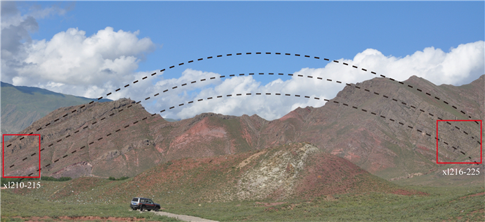
我们在林周县附近的一个设兴组背斜两翼 (图 2) 进行了系统的古地磁采样,获得16个采点共161块样品.样品在野外用磁罗盘和太阳罗盘共同定向,区域平均地磁偏角约为0.06°±0.02°(http://www.ngdc.noaa.gov/).在进行实验前样品被加工成大约2.2 cm长,切割剩下的新鲜碎样用来进行岩石学和岩石磁学实验.

|
图 1 拉萨林周地区区域地质简图,改自He等(2007) 剖面地层产状在等面积投影图中显示,其中褶皱的倾伏轴为(256.2°,19.0°).年代数据D-3,D-15来自周肃等(2004);LZ9,LZ10来自Cao等(2017);T233A来自Chen等(2014);SH系列来自He等(2007). Fig. 1 Schematic regional geological map of the Linzhou area, Lhasa (modified from He et al., 2007) Equal-area stereo net shows the bedding and plunging fold axis (256.2°, 19.0°) of the section. |
|
图 2 采样剖面野外照片,方框为采样点所在位置.剖面产状见图 1 Fig. 2 Photos of sampling section with boxes showing sampling sites. The bedding attitude of the section is shown in Fig. 1 |
古地磁样品的剩磁测试、岩石磁组构测试均在中国科学院地质与地球物理研究所古地磁与年代学实验室 (PGL) 进行.剩磁测试在2G-755超导磁力仪上进行,样品逐步热退磁处理在美制TD-48退磁炉上完成,岩石磁组构测试在Agico MFK1 Kappabridge上完成.热退磁温度在低温阶段间隔较大 (50~100 ℃),在高温阶段间隔变为10~5 ℃,全部样品均经过18步以上的退磁处理.样品的特征剩磁利用主成分分析法获得 (Kirschvink, 1980).古地磁数据的处理主要利用R. Enkin等编写的PMGSC和Lisa Tauxe等编写的PmagPy.
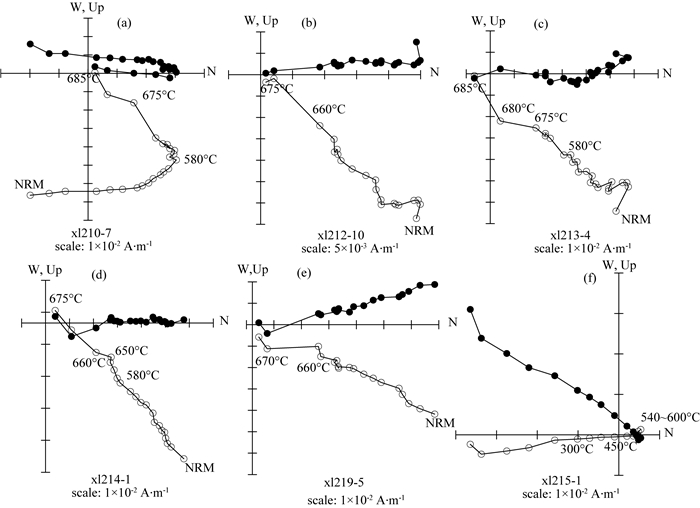
3.1 退磁结果经过热退磁后,161个样品中有148个样品的退磁曲线为单分量,另外13个样品为双分量 (其中采点xl210的两个样品的高温组分由于呈线性,因此也用主成分分析法拟合,图 3a).双分量的样品分别来自采点xl210(6个)和xl215(7个).大多数样品从500 ℃或580 ℃以后开始拟合.样品的低温分量过于分散,因此无法给出具有说服力的统计结果.部分样品的高温组分与原点有略微偏差 (图 3c).此外,在采点xl215中,出现3个无法回归退磁原点的样品 (图 3f),在等面积投影图上退磁曲线呈大圆弧形式出现.这一组样品的退磁曲线较为异常,除了无法回归退磁原点,在低温和高温阶段还出现了负极性方向,而且5个样品 (包括无法回归退磁原点的3个样品) 在大约580 ℃时磁化强度已经降到非常低,580 ℃后退磁曲线没有变化或表现为噪声.鉴于这一采点的退磁曲线质量较差,我们统计时将xl215采点排除在外,最后共有151块样品进行古地磁统计.
|
图 3 地理坐标系下代表样品系统热退磁的正交矢量投影图 实心圆圈和空心圆圈分别代表剩磁方向在水平面和铅垂面上的投影. Fig. 3 Orthogonal (Zijderveld) vector plots of representative specimens from the Shexing Fm. Directions are plotted in situ Solid and open circles represent vectors and endpoints projected onto horizontal and vertical planes, respectively. |
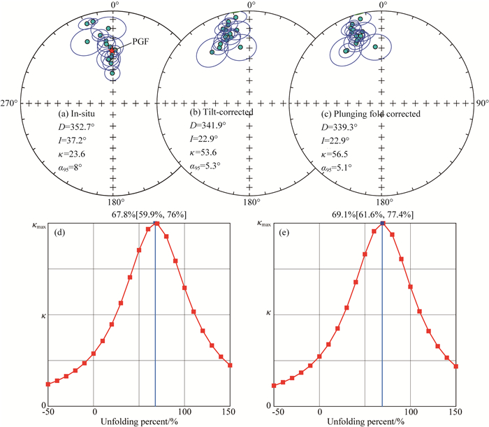
样品的高温分量进行主成分分析统计出特征剩磁后,对每个采点进行Fisher平均求出采样点的平均磁化方向,然后以采样点为单位进行平均,获得剖面的平均磁化方向 (图 4).计算古纬度时先求出每个采点所对应的虚地磁极,然后对这些虚地磁极进行Fisher平均,获得15个采点的古地磁极,最后通过古地磁极计算古纬度.如图 4所示,15个采点的平均方向在地理坐标系下为:Dg=352.7°,Ig=37.2°,κ=23.6,α95=8°,经过地层校正后:Ds=341.9°,Is=22.9°,κ=53.6,α95=5.3°,而经过地层校正和倾伏褶皱校正后 (以下称两步校正):Dp=339.3°,Is=22.9°,κ=56.5,α95=5.1°,所对应的古地磁极为63.8°N,323.0°E (A95=4.0).由于倾伏褶皱校正只改变磁偏角而不改变磁倾角,因此地层校正和两步校正的磁倾角在文中都标记为Is.
|
图 4 高温特征剩磁方向投影图 (等面积投影,a—c) 与Watson和Enkin褶皱检验 (d图为仅通过地层校正,e图通过地层校正与倾伏褶皱校正) Fig. 4 Equal-area projections of site-mean directions of the ChRMs before tilt correction (a), after tilt correction (b) and after two step correction (tilt correction with plunging fold axis) (c). Fold test for ChRMs isolated from Shexing Fm is indicative of a syn-tilt folding (d, tilt correction; e, two-step correction) |
由于采样点位于褶皱两翼 (图 2),因此我们对15个采点进行了褶皱检验.Watson和Enkin (1993) 褶皱检验显示,在经过地层校正后剩磁方向在大约67.8%±8%展开时达到最大集中,而在两步校正后在大约69.1%±8%展开时达到最大集中,反映剖面的特征剩磁可能为同褶皱时期获得.McFadden (1990) 褶皱检验显示在地理坐标系下ξ2=11.367,经过两步校正后ξ2=6.063,大于临界值4.510(N=15),方向在大约69%展开时获得最大集中,此时ξ1=0.239,这一结果为典型的同褶皱磁化结果.在69%展开时,特征剩磁的平均方向为:D=339.1°,I=27.3°(α95=4.1°),古地磁极为65.4°N,327.5°E (A95=3.5°),所对应的古纬度为15.0°N (参考点为29.3°N,88.5°E).
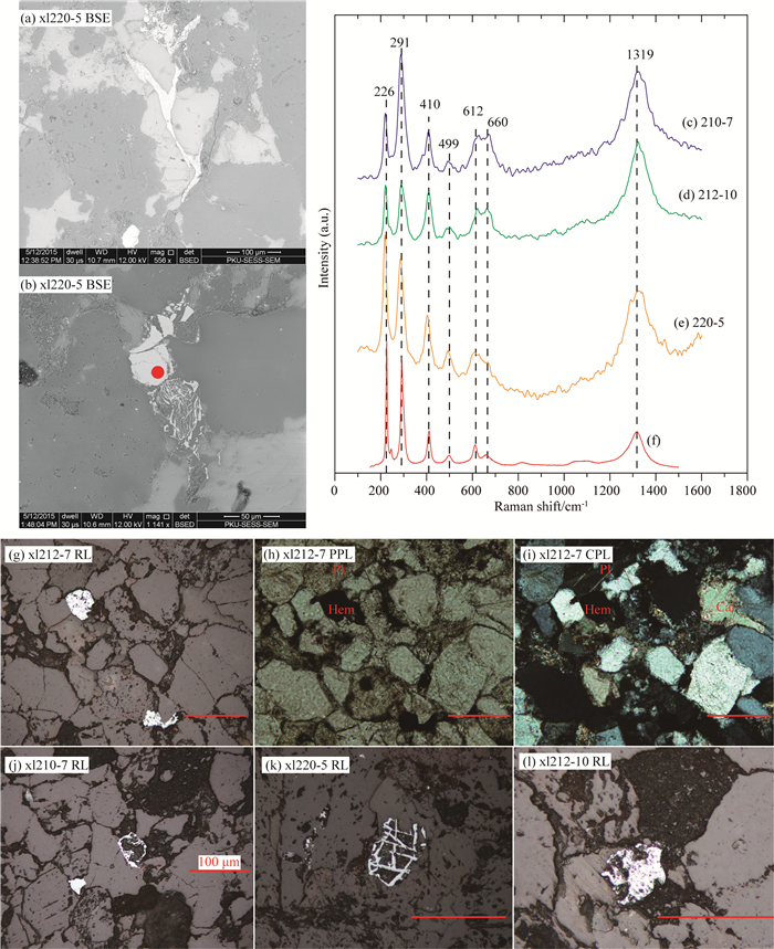
3.2 岩石学与岩石磁组构结果对来自古地磁采样点xl210,xl212和xl220的5块薄片进行了拉曼光谱分析,结果显示薄片中的金属矿物应为赤铁矿,但660 cm-1附近的肩形峰的出现可能说明有微量的磁铁矿的存在 (图 5c—5e).在镜下,赤铁矿多呈它形充填在石英颗粒空隙中 (图 5a, 5b, 5g, 5l);或者以假象的形式出现 (图 5j—5k),反映了赤铁矿可能是通过交代磁铁矿或钛铁矿形成.镜下可见赤铁矿的成因与暗红色-黑色的它形矿物有一定关系 (图 5),这种矿物一般充填在其他矿物间隙中,很可能是泥质和铁质胶结物.此外,部分赤铁矿具有相对复杂的结晶和变形历史,如图 5b所示,网格状赤铁矿为韧性变形,可能记录了形成过程中的应力,而上方的赤铁矿块体为脆性变形,两者共同在石英颗粒间隙中形成.
|
图 5 代表性样品镜下照片与拉曼光谱图像 图(b)中红点为拉曼光谱测试位置,图(c—e)为拉曼光谱结果,图(f)为理论的赤铁矿拉曼光谱,数据来自 http://www.ens-lyon.fr/LST/Raman/.BSE:背散射电子探头图像;RL:反射光;PPL:单偏光;CPL:正交偏光. Fig. 5 Back Scatter Election Detector Image (BSE) and thin section photographs of typical samples The Raman spectrum test area is shown by the red dot in (b) and result are (c)—(e), (f)represents theoretical Raman spectrum of hematite. RL, PPL, and CPL represent reflected light, plane polarized light and crossed polarized light, respectively. |
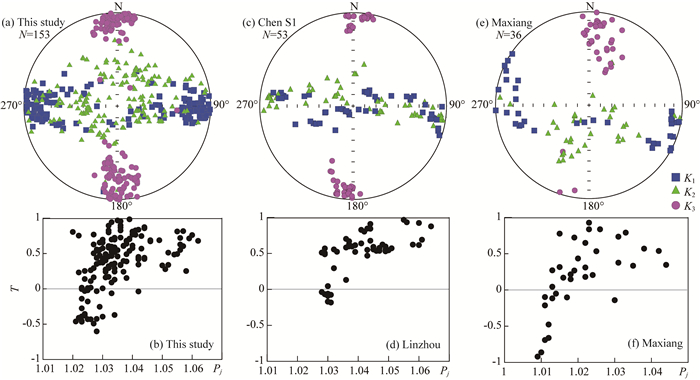
同时,我们对153个样品进行了岩石磁组构 (AMS) 测试,大部分样品的各向异性度小于1.06.在地理坐标系和地层坐标系下,磁化率各向异性椭球体K3轴大约呈南北向水平分布,K2轴和K1轴呈带状分布,但总体而言K1轴大部分呈东西向水平分布 (图 6a),而且与褶皱枢纽大致重合.这表明采样剖面 (林周盆地设兴组红层) 记录的并非是典型的沉积岩磁组构的特征 (如Weil and Yonkee, 2009),而是岩石形成后遭受了一定程度构造变形后的过渡型构造变形组构 (Transitional fabric);如果岩石继续发生变形,这种过渡型构造变形组构最终会演化为K1轴垂直的构造磁组构 (Graham, 1966; Borradaile and Henry, 1997).
|
图 6 地层坐标下设兴组磁化率各向异性椭球主轴方向赤平投影图(a,c,e)和Jelinek图解(修正的各向异性度(Pj)vs各向异性椭球形状因子(T))(b,d,f) (a,b)为本文的研究剖面; (c,d)为前人在林周盆地的研究剖面; (e,f)为马乡地区设兴组剖面.详细见文中3.2节. Fig. 6 (a,c,e) Stereo plots of three principal axes of anisotropy of magnetic susceptibility (AMS) in stratigraphic coordinates and (b,d,f) Jelinek plots (AMS degree Pj versus AMS shape parameter T) (a and b) are results of this study. (c and d) are from the other section in the Linzhou basin (9 sampling sites). (e and f) are from 4 sampling sites in the Maxiang area. See Section 3.2 for more details. |
事实上,区域内上白垩统设兴组红层普遍记录了这种过渡型构造变形组构.我们在前人的研究剖面上采集平行样品进行了磁组构分析,其中林周盆地的9个采样点与Tan等(2010) 的section A一致,这一剖面也是一直以来被广泛研究的剖面 (Pozzi et al., 1982; Westphal et al., 1983; Achache et al., 1984; Lin and Watts, 1988; Tan et al., 2010);马乡附近的4个采样点与前人的采样点一致 (Westphal et al., 1983; Achache et al., 1984; Sun et al., 2012).两个地区的岩石磁组构都是遭受了一定构造变形后的过渡型构造变形组构 (图 6c—6f).
|
|
表 1 林周盆地设兴组特征剩磁分量数据 Table 1 Site mean paleomagnetic directions of the Shexing Fm in the Linzhou basin, Lhasa block |
初步岩石学分析显示,在薄片下设兴组红层的主要载磁矿物赤铁矿除了以颗粒的形式出现外,还常以胶结物的形式充填在石英颗粒间隙中,或者以赤铁矿假象的形式出现.这些赤铁矿假象可能是交代磁铁矿或钛铁矿形成.胶结物形式的赤铁矿其形成的时间很可能为岩石成岩过程后期,而假象形式的赤铁矿形成时间应该在岩石形成之后.从薄片可以确定,样品中赤铁矿应为次生矿物,其成因很可能是成岩过程后期或岩石形成后通过化学反应形成,而非红层中常见的碎屑成因.因此,这种赤铁矿所记录的特征剩磁方向应为重磁化的结果.
最近Jiang等(2015) 的研究给出了一种快速识别化学剩磁 (CRM)和碎屑剩磁 (DRM) 的方法.他们认为,携带CRM的赤铁矿其解阻温度为~200-650 ℃,经过逐步热退磁后,天然剩磁 (NRM) 强度衰减曲线呈凹型 (concave);而携带DRM的赤铁矿其解阻温度一般稳定在~600-680 ℃,NRM强度衰减曲线呈凸型 (convex).在本文剖面中,161个样品中有9个样品的NRM强度衰减曲线呈凹型,这9个样品出现在采点xl210和xl215,但退磁曲线全部表现为双分量,其中包括xl215中3个无法回归原点的样品 (xl215-1, -5, -6).但在Jiang等的研究中,赤铁矿所携带的剩磁组分均为单分量,诚然,矫顽力谱或阻挡温度谱重叠较少的双分量也可以提供一些参考 (与姜兆霞个人交流,2016).因此,本文的双分量情形应该首先排除在外,不应在与Jiang等结果的对比范围内,因为双分量的情形,NRM强度的变化应与2个分量之间的关系相关.应该仅以单分量,甚至是清洗掉黏滞剩磁后的退磁曲线的NRM强度衰减曲线为讨论对象才合理.为此,根据Jiang等的识别方法,本文剖面样品的剩磁均为DRM.然而根据镜下赤铁矿的形态,本文设兴组背斜剖面中样品的赤铁矿应为化学成因,或至少是受到后期改造,所记录的剩磁应为CRM.但必须承认的是,剩磁信息实际上是岩石的宏观表现,从岩石学角度往往仅能分析到局部;而局部现象究竟能在多大程度上表征宏观,则需要岩石磁学等进一步工作来解答.
另一方面,姜兆霞 (2014) 的赤铁矿合成实验显示赤铁矿在生长过程中所记录的CRM也存在磁倾角变浅的问题.然而,对本文剖面的特征剩磁进行的E/I分析 (Tauxe and Kent, 2004; Tauxe, 2005; Tauxe et al., 2008) 显示,在校正前倾角Is=22.9°,α95=2.4°,校正后的倾角I=26.9°,置信区间为 (22.4°,32.3°),两者在置信区间内是一致的.因此,本文剖面的特征剩磁很可能没有发生显著的磁倾角变浅.
本次研究的采样点位于设兴组背斜两翼,褶皱检验显示样品的特征剩磁应为同褶皱时期磁化的结果.剖面的过渡型构造变形磁组构特征也支持这个解释.本区自白垩纪以来主要有两期构造活动,第一期为晚白垩世以前,第二期为古新世后,两期构造以区域不整合面为界.这一不整合的年代大约为65 Ma (莫宣学等,2003;周肃等,2004; He et al., 2007; Mo et al., 2007).现有地质资料显示,白垩系发生强烈褶皱,而古近纪林子宗群火山岩及沉积岩夹层相对较为平缓,第一期构造远比第二期强烈 (Allégre et al., 1984; Yin and Harrison, 2000; He et al., 2007; Leier et al., 2007; van Hinsbergen et al., 2011).鉴于特征剩磁方向在大约69%展开时获得最大集中,我们认为剖面的特征剩磁很可能为第一期构造时获得.
4.2 重磁化年龄精确地限定重磁化年龄,一直是古地磁学中的难题.在本次研究中,我们认为本剖面的设兴组红层中的特征剩磁组分应为第一期构造时获得的磁化,因此重磁化的年代可以根据第一期构造的时间大致确定.第一期构造的上限为区域不整合面,年代约为64.43±0.5 Ma (周肃等,2004),下限应为设兴组的形成时代.但设兴组的形成年代至今仍有争议.塔克那组的化石显示沉积时代为Aptian-Albian阶 (Leier et al., 2007),反映了设兴组的沉积下限应为~110 Ma.近年来堆龙德庆马乡地区设兴组上部火山岩夹层的锆石U-Pb年代学研究显示,设兴组最晚的沉积年龄约为72.4±1.8 Ma (Sun et al., 2012).最近在林周盆地设兴组上部玄武岩夹层的K-Ar年代学研究也给出类似的结果 (69.75±1.53 Ma和73.75±1.26 Ma,图 1) (Cao et al., 2017),但在同一个剖面中,李晓雄等(2015) 得到斜长石Ar-Ar年龄为90.6±1.8 Ma.在马乡地区,设兴组砂岩碎屑锆石最年轻的年龄峰值约为88 Ma,而最年轻的锆石U-Pb年龄为81±1 Ma,表明设兴组的沉积上限约为81 Ma (井天景,2014).设兴组沉积年代进一步的探讨超出本文的范围,但根据现有数据,优先选用设兴组上部火山岩夹层的年代数据.因此,我们认为设兴组的沉积上限约为72.4±1.8 Ma,第一期构造的年代为64.43±0.5 Ma至72.4±1.8 Ma,这一结果与Leier等(2007) 得到的设兴组地层变形年龄一致.
根据以上分析,我们认为重磁化时代约为64.43±0.5 Ma-72.4±1.8 Ma,剩磁获得时采样剖面的古纬度约为15.0°N±3.5°.
4.3 区域红层古地磁结果与构造缩短量拉萨地块林周盆地设兴组红层的古地磁数据一直存在较大争议,前人恢复的古纬度从7.6°N到21.8°N不等(Pozzi et al., 1982; Westphal et al., 1983; Achache et al., 1984; Lin and Watts, 1988; Tan et al., 2010; Cao et al., 2017).Tan等(2010) 认为造成这种分歧的原因是红层中记录的原生剩磁组分由于沉积压实等其他作用发生了显著的磁倾角变浅.Tan等对林周盆地设兴组红层数据进行E/I校正后 (Tauxe and Kent, 2004; Tauxe, 2005; Tauxe et al., 2008),古纬度从12.4°N±1.4°变为~22.5°(参考点为30°N,90°E),与他们所得的火山岩数据相一致 (24.2°N±3.3°).然而其他研究组对比红层与火山岩数据时发现两者所记录的古纬度在置信区间内是一致的,红层并未发生显著磁倾角浅化的现象 (Sun et al., 2012; Yang et al., 2015; Cao et al., 2017).
在我们的研究剖面中,赤铁矿多呈它形胶结物、假象等形式出现,AMS为过渡型构造变形磁组构,样品所记录的特征剩磁为同褶皱重磁化的结果.在林周盆地其他剖面及马乡一带,绝大多数岩石磁组构也表现为过渡型构造变形磁组构 (K3轴水平,K1轴与K2轴呈带状分布,图 6).我们推测区域内红层可能遭受了广泛的重磁化.但由于重磁化的时代不同,导致所记录的古纬度变化较大:重磁化时代越接近成岩时代,所记录的磁倾角相对较低,古地磁数据越接近正的褶皱检验结果;反之所记录的磁倾角相对较高,褶皱检验为显著同褶皱重磁化,甚至接近于负的褶皱检验.
现有地质资料显示,拉萨地块在晚侏罗世-早白垩世与羌塘地块碰撞,最终形成亚洲大陆最南缘 (Tapponnier et al., 1981; Allégre et al., 1984; Yin and Harrison, 2000).参照欧亚大陆视极移曲线 (Besse and Courtillot, 2002) 所指示的刚性欧亚大陆南缘的古位置期望值,根据本文获得的古地磁结果,表明~70 Ma以来拉萨地块与稳定欧亚大陆之间的南北向构造缩短量最少为1200±400 km (11.1°±3.5°).然而根据平衡剖面资料,青藏高原及其北部 (包括天山和蒙古) 在新生代的构造缩短量仅为750 km (van Hinsbergen et al., 2011) 或923 km (Johnson, 2002),造成这种差异的原因可能是因为平衡剖面这种方法的局限性.近年来地震层析成像结果发现在青藏高原~1100~900 km深度有一个高速异常 (图 7中AS),前人将其解释为在~45 Ma以后滞留在深部的欧亚大陆岩石圈板片,并推断欧亚大陆的俯冲量最多可达400 km (Replumaz et al., 2013).再加上如今俯冲在青藏高原中部之下的欧亚大陆俯冲板片 (大约200 km),自碰撞以来欧亚大陆岩石圈地幔最高可消减约600 km (Replumaz et al., 2013).因此平衡剖面与欧亚大陆俯冲板片两者估算的构造缩短量约为1350~1523 km,与我们古地磁结果所估算的相一致.

|
图 7 拉萨地块晚白垩世古地理位置重建图,改自Replumaz等(2013) 红线代表碰撞前的拉萨地块.古地磁数据的参考点为各自的采样点. Fig. 7 Paleogeographic reconstruction of the Lhasa block in late Cretaceous (modified from Replumaz et al., 2013) The red line represents the Lhasa block before collision. Reference sites are the respective sampling sites. |
拉萨地块是欧亚大陆最后拼贴的活动大陆边缘,代表了碰撞前欧亚大陆的最南缘.现有的古地磁数据显示,拉萨地块的古纬度从早白垩世到古新世保持相对稳定,在古地磁精度范围内并无明显的南北向移动且大约处于10°N—15°N (Achache et al., 1984; Chen et al., 2010, 2014; Liebke et al., 2010; Sun et al., 2010, 2012;唐祥德等,2013; Ma et al., 2014; Yang et al., 2015; Yi et al., 2015; Cao et al., 2017; Li et al., 2017).此外,Yi等(2015) 在拉萨地块西部狮泉河和亚热盆地的研究发现,雅鲁藏布缝合带在经过旋转恢复后大约呈310°N展布.通过对比拉萨地块东部和西部的古地磁数据,他们认为拉萨地块在碰撞前呈NNW—SSE向准线性展布.这一结果与Replumaz和Tapponnier (2003) 通过地质资料等恢复的欧亚大陆南缘呈NW—SE向线性展布的结果相一致.
现有的地震层析成像资料显示,在现今印度大陆~1000 km深度以下存在一个高速异常TH (图 7),代表了过去的特提斯洋板片 (Van der Voo et al., 1999; Replumaz et al., 2010, 2014).按照现今活动大陆边缘的地震层析成像资料以及俯冲带的模拟 (Chemenda et al., 2000; Zhao, 2009; Zhao and Ohtani, 2009; Replumaz et al., 2013),活动大陆边缘至少与滞留在地幔的俯冲板片处于相近的位置或者是在其前缘,例如太平洋板块俯冲到日本岛弧之下,其滞留在上地幔的板片可到达中国的五大连池 (Zhao and Ohtani, 2009).因此,碰撞前拉萨地块的古地理位置应该与高速异常TH (图 7) 的位置相当或者是在高速异常TH南边.
综合考虑拉萨地块东部和西部的晚白垩世古地磁数据,并根据拉萨地块在碰撞前呈NW—SE向准线性展布 (Replumaz and Tapponnier, 2003; Yi et al., 2015),我们认为拉萨地块在碰撞前应处于~10°N—15°N (图 7红线).结合近年来特提斯喜马拉雅的古地磁数据 (Yi et al., 2011),即便认为拉萨地块一直处于15°N,在大约56—59 Ma时特提斯喜马拉雅与拉萨地块的纬度差仅为3.0°±3.2°.由于印度大陆在大约55 Ma以前向北移动的速度大约是18~19.5 cm·a-1(每百万年1.6°~1.8°,Klootwijk et al., 1992),因此特提斯喜马拉雅的古地理位置至少在大约55 Ma时就与拉萨地块重合,印度大陆与欧亚大陆发生碰撞.综上所述,我们认为印度大陆与欧亚大陆的碰撞应不晚于~55 Ma.
致谢感谢次仁卓玛、布琼对我们野外工作的大力支持.特别感谢北京大学田伟副教授、赖勇教授、宋述光教授在岩石学上对我们的指导和帮助.另外感谢两位匿名评审专家对本文提出重要的修改意见.
| Achache J, Courtillot V, Xiu Z Y. 1984. Paleogeographic and tectonic evolution of southern Tibet since middle Cretaceous time: new paleomagnetic data and synthesis. Journal of Geophysical Research: Solid Earth, 89(B12): 10311-10339. DOI:10.1029/JB089iB12p10311 | |
| Aitchison J C, Ali J R, Davis A M. 2007. When and where did India and Asia collide?. Journal of Geophysical Research-Solid Earth, 112: B05423. | |
| Allégre C O, Courtillot V, Tapponnier P, et al. 1984. Structure and evolution of the Himalaya-Tibet orogenic belt. Nature, 307(5946): 17-22. DOI:10.1038/307017a0 | |
| Besse J, Courtillot V. 2002. Apparent and true polar wander and the geometry of the geomagnetic field over the last 200 Myr. Journal of Geophysical Research: Solid Earth, 107(B11): EPM 6-1-EPM 6-31. DOI:10.1029/2000JB000050 | |
| Borradaile G J, Henry B. 1997. Tectonic applications of magnetic susceptibility and its anisotropy. Earth-Science Reviews, 42(1-2): 49-93. DOI:10.1016/S0012-8252(96)00044-X | |
| Cao Y, Sun Z M, Li H B, et al. 2017. New Late Cretaceous paleomagnetic data from volcanic rocks and red beds from the Lhasa terrane and its implications for the paleolatitude of the southern margin of Asia prior to the collision with India. Gondwana Research, 41: 337-351. DOI:10.1016/j.gr.2015.11.006 | |
| Chemenda A I, Burg J P, Mattauer M. 2000. Evolutionary model of the Himalaya-Tibet system: geopoem: based on new modelling, geological and geophysical data. Earth and Planetary Science Letters, 174(3-4): 397-409. DOI:10.1016/S0012-821X(99)00277-0 | |
| Chen J S, Huang B C, Sun L S. 2010. New constraints to the onset of the India-Asia collision: Paleomagnetic reconnaissance on the Linzizong Group in the Lhasa Block, China. Tectonophysics, 489(1-4): 189-209. DOI:10.1016/j.tecto.2010.04.024 | |
| Chen J S, Huang B C, Yi Z Y, et al. 2014. Paleomagnetic and 40Ar/39Ar geochronological results from the Linzizong Group, Linzhou Basin, Lhasa Terrane, Tibet: Implications to Paleogene paleolatitude and onset of the India-Asia collision. Journal of Asian Earth Sciences, 96: 162-177. DOI:10.1016/j.jseaes.2014.09.007 | |
| Chen W W, Yang T S, Zhang S H, et al. 2012. Paleomagnetic results from the Early Cretaceous Zenong Group volcanic rocks, Cuoqin, Tibet, and their paleogeographic implications. Gondwana Research, 22(2): 461-469. DOI:10.1016/j.gr.2011.07.019 | |
| Chen Y, Cogné J P, Courtillot V, et al. 1993. Cretaceous paleomagnetic results from western Tibet and tectonic implications. Journal of Geophysical Research, 98(B10): 17981-17981. DOI:10.1029/93JB01006 | |
| Graham J W. 1966. Significance of magnetic anisotropy in Appalachian sedimentary rocks.//Steinhart J S, Smith J T. The Earth Beneath the Continents. Washington, D.C.: American Geophysical Union, 627-648. | |
| He S D, Kapp P, DeCelles P G, et al. 2007. Cretaceous-Tertiary geology of the Gangdese Arc in the Linzhou area, southern Tibet. Tectonophysics, 433(1-4): 15-37. DOI:10.1016/j.tecto.2007.01.005 | |
| Jiang Z X. 2014. The magnetic mechanism of antiferromagnetic minerals: illustrated by the case of Al substituted hematite and Al substituted goethite [Ph. D. thesis] (in Chinese). Beijing: University of Chinese Academy of Sciences. | |
| Jiang Z X, Liu Q S, Dekkers M J, et al. 2015. Acquisition of chemical remanent magnetization during experimental ferrihydrite-hematite conversion in Earth-like magnetic field—implications for paleomagnetic studies of red beds. Earth and Planetary Science Letters, 428: 1-10. DOI:10.1016/j.epsl.2015.07.024 | |
| Jing T J. 2014. Geochronology, geochemistry and implications of the sandstones in Shexing formation in Maxiang area, Tibet [Master's thesis] (in Chinese). Beijing: China University of Geosciences. | |
| Johnson M R W. 2002. Shortening budgets and the role of continental subduction during the India-Asia collision. Earth-Science Reviews, 59(1-4): 101-123. DOI:10.1016/S0012-8252(02)00071-5 | |
| Kirschvink J L. 1980. The least-squares line and plane and the analysis of palaeomagnetic data. Geophysical Journal International, 62(3): 699-718. DOI:10.1111/gji.1980.62.issue-3 | |
| Klootwijk C T, Gee J S, Peirce J W, et al. 1992. An early India-Asia contact: paleomagnetic constraints from Ninetyeast ridge, ODP Leg 121. Geology, 20(5): 395-398. DOI:10.1130/0091-7613(1992)020<0395:AEIACP>2.3.CO;2 | |
| Leier A L, DeCelles P G, Kapp P, et al. 2007. The Takena Formation of the Lhasa terrane, southern Tibet: The record of a Late Cretaceous retroarc foreland basin. Geological Society of America Bulletin, 119(1-2): 31-48. DOI:10.1130/B25974.1 | |
| Li X, Jiang W, Liang J H, et al. 2015. The geochemical characteristics and significance of the basalt from Shexing Formation in Linzhou basin, southern Tibet. Acta Petrologica Sinica (in Chinese), 31(5): 1285-1297. | |
| Li Z Y, Ding L, Song P P, et al. 2017. Paleomagnetic constraints on the paleolatitude of the Lhasa block during the Early Cretaceous: Implications for the onset of India-Asia collision and latitudinal shortening estimates across Tibet and stable Asia. Gondwana Research, 41: 352-372. DOI:10.1016/j.gr.2015.05.013 | |
| Liebke U, Appel E, Ding L, et al. 2010. Position of the Lhasa terrane prior to India-Asia collision derived from palaeomagnetic inclinations of 53 Ma old dykes of the Linzhou Basin: constraints on the age of collision and post-collisional shortening within the Tibetan Plateau. Geophysical Journal International, 182(3): 1199-1215. DOI:10.1111/j.1365-246X.2010.04698.x | |
| Lin J L, Watts D R. 1988. Palaeomagnetic results from the Tibetan Plateau. Philosophical Transactions of the Royal Society A: Mathematical, Physical and Engineering Sciences, 327(1594): 239-262. DOI:10.1098/rsta.1988.0128 | |
| Ma Y M, Yang T S, Yang Z Y, et al. 2014. Paleomagnetism and U-Pb zircon geochronology of Lower Cretaceous lava flows from the western Lhasa terrane: New constraints on the India-Asia collision process and intracontinental deformation within Asia. Journal of Geophysical Research: Solid Earth, 119(10): 7404-7424. DOI:10.1002/2014JB011362 | |
| McFadden P L. 1990. A new fold test for palaeomagnetic studies. Geophysical Journal International, 103(1): 163-169. DOI:10.1111/gji.1990.103.issue-1 | |
| Mo X X, Zhao Z D, Deng J F, et al. 2003. Response of volcanism to the India-Asia collision. Earth Science Frontiers (in Chinese), 10(3): 135-148. | |
| Mo X X, Hou Z Q, Niu Y L, et al. 2007. Mantle contributions to crustal thickening during continental collision: evidence from Cenozoic igneous rocks in southern Tibet. Lithos, 96(1-2): 225-242. DOI:10.1016/j.lithos.2006.10.005 | |
| Pozzi J P, Westphal M, Zhou Y X, et al. 1982. Position of the Lhasa block, South Tibet, during the late Cretaceous. Nature, 297(5864): 319-321. DOI:10.1038/297319a0 | |
| Replumaz A, Tapponnier P. 2003. Reconstruction of the deformed collision zone between India and Asia by backward motion of lithospheric blocks. Journal of Geophysical Research: Solid Earth, 108: 2285. | |
| Replumaz A, Negredo A M, Guillot S, et al. 2010. Multiple episodes of continental subduction during India/Asia convergence: Insight from seismic tomography and tectonic reconstruction. Tectonophysics, 483(1-2): 125-134. DOI:10.1016/j.tecto.2009.10.007 | |
| Replumaz A, Guillot S, Villaseñor A, et al. 2013. Amount of Asian lithospheric mantle subducted during the India/Asia collision. Gondwana Research, 24(3-4): 936-945. DOI:10.1016/j.gr.2012.07.019 | |
| Replumaz A, Capitanio F A, Guillot S, et al. 2014. The coupling of Indian subduction and Asian continental tectonics. Gondwana Research, 26(2): 608-626. DOI:10.1016/j.gr.2014.04.003 | |
| Sun Z M, Jiang W, Pei J L, et al. 2008. New early Cretaceous paleomagnetic data from volcanic of the eastern Lhasa Block and its tectonic implications. Acta Petrologica Sinica (in Chinese), 24(7): 1621-1626. | |
| Sun Z M, Jiang W, Li H B, et al. 2010. New paleomagnetic results of Paleocene volcanic rocks from the Lhasa block: Tectonic implications for the collision of India and Asia. Tectonophysics, 490(3-4): 257-266. DOI:10.1016/j.tecto.2010.05.011 | |
| Sun Z M, Pei J L, Li H B, et al. 2012. Palaeomagnetism of late Cretaceous sediments from southern Tibet: Evidence for the consistent palaeolatitudes of the southern margin of Eurasia prior to the collision with India. Gondwana Research, 21(1): 53-63. DOI:10.1016/j.gr.2011.08.003 | |
| Tan X D, Gilder S, Kodama K P, et al. 2010. New paleomagnetic results from the Lhasa block: Revised estimation of latitudinal shortening across Tibet and implications for dating the India-Asia collision. Earth and Planetary Science Letters, 293(3-4): 396-404. DOI:10.1016/j.epsl.2010.03.013 | |
| Tang X D, Huang B C, Yang L K, et al. 2013. Paleomagnetism and Ar-Ar geochronology of Cretaceous volcanic rocks in the middle Lhasa Terrane, China and tectonic implications. Chinese J. Geophys. (in Chinese), 56(1): 136-149. DOI:10.6038/cjg20130114 | |
| Tapponnier P, Mercier J L, Proust F, et al. 1981. The Tibetan side of the India-Eurasia collision. Nature, 294(5840): 405-410. DOI:10.1038/294405a0 | |
| Tauxe L, Kent D V. 2004. A simplified statistical model for the geomagnetic field and the detection of shallow bias in paleomagnetic inclinations: was the ancient magnetic field dipolar?//Timescales of the Paleomagnetic Field. Washington, D. C.: AGU, 101-115. | |
| Tauxe L. 2005. Inclination flattening and the geocentric axial dipole hypothesis. Earth and Planetary Science Letters, 233(3-4): 247-261. DOI:10.1016/j.epsl.2005.01.027 | |
| Tauxe L, Kodama K P, Kent D V. 2008. Testing corrections for paleomagnetic inclination error in sedimentary rocks: a comparative approach. Physics of the Earth and Planetary Interiors, 169(1-4): 152-165. DOI:10.1016/j.pepi.2008.05.006 | |
| Van der Voo R, Spakman W, Bijwaard H. 1999. Tethyan subducted slabs under India. Earth and Planetary Science Letters, 171(1): 7-20. DOI:10.1016/S0012-821X(99)00131-4 | |
| van Hinsbergen D J J, Kapp P, Dupont-Nivet G, et al. 2011. Restoration of Cenozoic deformation in Asia and the size of Greater India. Tectonics, 30:TC5003, doi:5010.1029/2011 TC002908. | |
| van Hinsbergen D J J, Lippert P C, Dupont-Nivet G, et al. 2012. Greater India Basin hypothesis and a two-stage Cenozoic collision between India and Asia. Proceedings of the National Academy of Sciences of the United States of America, 109(20): 7659-7664. DOI:10.1073/pnas.1117262109 | |
| Wang N W, Wang S S, Liu G F, et al. 1983. The Juro-Cretaceous marine-terrestrial alternating formations in Lhasa area, Xizang (Tibet). Acta Geologica Sinica (in Chinese), 57(1): 83-95. | |
| Watson G S, Enkin R J. 1993. The fold test in paleomagnetism as a parameter estimation problem. Geophysical Research Letters, 20(19): 2135-2137. DOI:10.1029/93GL01901 | |
| Weil A B, Yonkee A. 2009. Anisotropy of magnetic susceptibility in weakly deformed red beds from the Wyoming salient, Sevier thrust belt: Relations to layer-parallel shortening and orogenic curvature. Lithosphere, 1(4): 235-256. DOI:10.1130/L42.1 | |
| Westphal M, Pozzi J P, Zhou Y X, et al. 1983. Palaeomagnetic data about southern Tibet (Xizang)—Ⅰ. The Cretaceous formations of the Lhasa block. Geophysical Journal International, 73(2): 507-521. | |
| Yang T S, Ma Y M, Zhang S H, et al. 2015. New insights into the India-Asia collision process from Cretaceous paleomagnetic and geochronologic results in the Lhasa terrane. Gondwana Research, 28(2): 625-641. DOI:10.1016/j.gr.2014.06.010 | |
| Yi Z Y, Huang B C, Chen J S, et al. 2011. Paleomagnetism of early Paleogene marine sediments in southern Tibet, China: Implications to onset of the India-Asia collision and size of Greater India. Earth and Planetary Science Letters, 309(1-2): 153-165. | |
| Yi Z Y, Huang B C, Yang L K, et al. 2015. A quasi-linear structure of the southern margin of Eurasia prior to the India-Asia collision: First paleomagnetic constraints from Upper Cretaceous volcanic rocks near the western syntaxis of Tibet. Tectonics, 34(7): 1431-1451. DOI:10.1002/tect.v34.7 | |
| Yin A, Harrison T M. 2000. Geologic evolution of the Himalayan-Tibetan orogen. Annual Review of Earth and Planetary Sciences, 28(1): 211-280. DOI:10.1146/annurev.earth.28.1.211 | |
| Zhao D P. 2009. Multiscale seismic tomography and mantle dynamics. Gondwana Research, 15(3-4): 297-323. DOI:10.1016/j.gr.2008.07.003 | |
| Zhao D P, Ohtani E. 2009. Deep slab subduction and dehydration and their geodynamic consequences: Evidence from seismology and mineral physics. Gondwana Research, 16(3-4): 401-413. DOI:10.1016/j.gr.2009.01.005 | |
| Zhou S, Mo X X, Dong G C, et al. 2004. 40Ar-39Ar geochronology of Cenozoic Linzizong volcanic rocks from Linzhou Basin, Tibet, China, and their geological implications. Chinese Science Bulletin, 49(18): 1970-1979. DOI:10.1007/BF03184291 | |
| Zhu D C, Zhao Z D, Niu Y L, et al. 2011. The Lhasa Terrane: Record of a microcontinent and its histories of drift and growth. Earth and Planetary Science Letters, 301(1-2): 241-255. DOI:10.1016/j.epsl.2010.11.005 | |
| Zhu D C, Zhao Z D, Niu Y L, et al. 2013. The origin and pre-Cenozoic evolution of the Tibetan Plateau. Gondwana Research, 23(4): 1429-1454. DOI:10.1016/j.gr.2012.02.002 | |
| Zhu X Y, Liu C, Ye S J, et al. 1977. Remanence of red beds from Linzhou, Xizang and the northward movement of the Indian plate. Scientia Geologica Sinica. | |
| Zhu Z W, Zhu X Y, Zhang Y M. 1981. Palaeomagnetic observation in Xizang and continental drift. Chinese J. Geophys. (Acta Geophysica Sinica) (in Chinese), 24(1): 40-49. | |
| 姜兆霞. 2014. 反铁磁性矿物的磁性机制研究——以含铝赤铁矿和含铝针铁矿为例[博士论文]. 北京: 中国科学院大学. | |
| 井天景. 2014. 西藏马乡设兴组砂岩锆石U-Pb年代学、岩石地球化学及其意义[硕士论文]. 北京: 中国地质大学 (北京). | |
| 李晓雄, 江万, 梁锦海, 等. 2015. 西藏林周盆地设兴组玄武岩地球化学特征及意义. 岩石学报, 31: 1285–1297. | |
| 莫宣学, 赵志丹, 邓晋福, 等. 2003. 印度—亚洲大陆主碰撞过程的火山作用响应. 地学前缘, 10(3): 135–148. | |
| 孙知明, 江万, 裴军令, 等. 2008. 青藏高原拉萨地块早白垩纪火山岩古地磁结果及其构造意义. 岩石学报, 24: 1621–1626. | |
| 唐祥德, 黄宝春, 杨列坤, 等. 2013. 拉萨地块中部晚白垩世火山岩Ar-Ar年代学和古地磁研究结果及其构造意义. 地球物理学报, 56(1): 136–149. DOI:10.6038/cjg20130114 | |
| 王乃文, 王思恩, 刘桂芳, 等. 1983. 西藏拉萨地区的海陆交互相侏罗系与白垩系. 地质学报, 57(1): 83–95. | |
| 周肃, 莫宣学, 董国臣, 等. 2004. 西藏林周盆地林子宗火山岩40Ar/39Ar年代格架. 科学通报, 49(20): 2095–2103. DOI:10.3321/j.issn:0023-074X.2004.20.014 | |
| 朱湘元, 刘椿, 叶素娟, 等. 1977. 西藏林周地区红层的天然剩余磁性和印度洋板块的北向移动. 地质科学(1): 44–51. | |
| 朱志文, 朱湘元, 张一鸣. 1981. 西藏高原古地磁及大陆漂移. 地球物理学报, 24(1): 40–49. | |
 2017, Vol. 60


