 2017, Vol. 60


2. 中国地震局地质研究所, 地震动力学国家重点实验室, 北京 100029
2. State Key Laboratory of Earthquake Dynamics, Institute of Geology, China Earthquake Administration, Beijing 100029, China
羌塘盆地是我国一个重要的海相沉积盆地, 有较好储油前景 (赵政璋等, 1997).羌塘盆地位于班公-怒江缝合带和可可西里-金沙江缝合带之间, 整体上分为南羌塘坳陷、中央隆起和北羌塘坳陷三个构造单元 (黄继钧, 2001).羌塘中央隆起成东西走向, 沿岗玛错、玛依岗日、查桑至西雅尔岗.关于羌塘盆地演化模式目前存在两种不同观点.其主要争议在于对羌塘盆地中央隆起构造成因的解释.一种观点认为, 该中央隆起在伸展构造环境下形成, 羌塘盆地虽被中央隆起分割, 但有着统一基底 (王成善等, 1987; 黄继钧, 2001; 尹福光, 2003; 付修根等, 2010; Kapp et al., 2000, 2003).据此推断, 南北羌塘应具有相似的深部结构特征.另一种观点认为中央隆起是一古特提斯缝合带, 南北羌塘是两个演化机制不同的构造单元 (李才, 1987, 2008; 李才等, 2001; Zhang et al., 2006; Zhai et al., 2011).羌塘盆地中央隆起的成因对于确定羌塘盆地构造演化, 甚至青藏高原的演化有重要意义 (Gao et al., 2005).此外, 北羌塘盆地北部, 广泛分布的一系列新生代钾质与超钾质火山 (邓万明等, 1996; Hacker et al., 2000; Chung et al., 2005) 代表着北羌塘北部在10 Ma左右发生过强烈的壳幔相互作用使得北羌塘盆地北缘中上地壳发生了广泛的南向逆冲作用, 彻底改造了北羌塘盆地 (黄继钧, 2001), 这对北羌塘盆地内油气形成与运移产生了重要影响 (赵政璋等, 1997).因此, 开展羌塘盆地下地壳结构特征研究对于羌塘中部的区域构造研究有着重要意义.
目前, 在羌塘盆地已经开展了多种地球物理探测研究, 主要有重力与磁力 (苑守成等, 2007; 郑洪伟等, 2010, 2012; 王喜臣等, 2008; He et al., 2014)、大地电磁测深 (张胜业等, 1996; 鲁兵等, 2003; 郭新峰等, 1990; 马晓冰等, 1997; 孔祥儒等, 1996; 魏文博等, 2006)、深地震反射探测 (Ross et al., 2004; 卢占武等, 2006a, 2006b; Gao et al., 2013; Lu et al., 2013)、深地震测深 (Zhao et al., 2001; Haines et al., 2003) 和宽频带地震观测 (Tilmann et al., 2003; Wittlinger et al., 1996, 2004; Tian et al., 2005; 郑洪伟等, 2007; 邹长桥等, 2012; 刘国成等, 2014).前人研究结果均表明, 羌塘中央隆起两侧深部结构存在复杂差异.如邹长桥等 (2012)通过远震P波层析成像方法得到了层析成像结果清楚地显示了羌塘中央隆起是一重大边界构造断裂带, 两侧岩石圈存在明显差异.刘国成等 (2014)使用相同数据分别使用CCP叠加方法和H-κ扫描方法计算了所有数据, 认为班公湖-怒江缝合带下Moho存在一个南深北浅的陡台阶, 断距约10 km.
本文所用远震波形数据与邹长桥等 (2012), 刘国成等 (2014)相同, 都来自于中国地质科学院地质研究所 (TITAN-I项目).本文目的是沿88.5°E南北纵跨羌塘盆地中央隆起的剖面AB (剖面AB位置见图 1) 开展接收函数分析, 利用接收函数复谱比共轭梯度非线性反演方法 (刘启元等, 1996) 获取该剖面下方100 km深度范围内地壳S波速度模型.由于沿该剖面实施了深地震反射剖面 (Gao et al., 2013), 这更有助于开展综合相关研究.

|
图 1 羌塘宽频带地震野外流动观测台站位置图 图中红色直线AB是本文研究剖面位置.右上插图表示整体青藏高原构造轮廓.蓝色实心圆表示本文研究所用台站, 红色实心圆表示其余布设的台站, 插图中方框表示图 1研究区位置.BNS班公湖-怒江缝合带, LSS龙木措-双湖缝合带, JS金沙江缝合带.黑色三角表示冷泉, 红色三角表示热泉. Fig. 1 Distribution of seismological study in Qiangtang Red line AB stands for the profile in this study.Blue solid circles denote broadband seismic stations used in this study.Red solid circles are the other broadband seismic stations installed.Inset in up-right corner presents some major tectonics in Tibet.Black box in inset indicates the location of Fig. 1.BNS, Bangong-Nujiang suture zone; LSS, Longmuco-Shuanghu suture zone; JS, Jinshajiang suture zone.Black triangle is cold spring. Red triangles are hot springs. |
本文所用数据台站分布在班公-怒江缝合带和可可西里-金沙江缝合带之间, 如图 1显示本文使用台站主要沿88.5°E分布.野外流动观测台采用了CMG-3ESP_60s地震计和REFTEK-130-1数据采集器.数据采集采样率为50 Hz.流动台站间距大概在10 km左右.数据记录时间从2008年9月至2010年11月的远震事件 (图 2).在数据解编过程中, 对台站高程参数月平均处理, 并考虑了GPS的高程与地震计之间的高程差.地震事件目录参考美国地质调查局 (USGS: http://www.usgs.gov/[2014-02-01]), 所选取远震事件MS震级不小于5.5, 震中距在30°到90°之间 (图 2).对于所研究的27个台站, 共挑选出338个地震事件的738条远震P波到时数据.

|
图 2 本文研究中远震事件震中分布图 中间空心三角为本研究区; 周围红色五角星为地震事件. Fig. 2 The earthquake distribution (red stars) used in receiver function analysis in this study The triangle is the study area. |
接收函数方法 (Langston, 1977, Owens et al., 1984; Ammon, 1991) 现在已成为研究观测台站下方结构的重要常规手段.首先对原始三分量地震事件数据处理, 以采样频率20 Hz重采样.使用SAC处理数据, 去除线性趋势, 去平均, 坐标旋转, 采用0.05~2 Hz带通滤波.然后提取接收函数, 本文提取接收函数方法采用时间域迭代反褶积 (Ligorría and Ammon, 1999).接收函数计算从起跳前10 s开始, 滤波系数α为1.5.
本文通过接收函数反演得到观测台站下方地壳S波速度结构.接收函数反演分为线性反演 (Ammon et al., 1990; Ammon and Zandt, 1993) 和非线性反演 (刘启元等, 1996; 高星等, 2005).线性反演方法运算速度快, 但要求初始模型必须充分接近真实地壳速度结构 (Ammon et al., 1990; Ammon and Zandt, 1993).而接收函数非线性反演方法, 如模拟退火等 (高星等, 2005)、遗传算法 (Shibutani et al., 1996), 难以快速收敛.刘启元等 (1996)开发了接收函数复谱比非线性反演法.该方法不仅收敛速度快, 而且巧妙地引入时间域接收函数垂向 (Z分量) 与径向 (R分量) 初至振幅比来有效地降低了反演多解性 (刘启元等, 1997, 2000; 陈九辉等, 2005; Li et al., 2007; 王峻等, 2009).从而, 克服了接收函数径向分量不包含传播介质的绝对信息 (Ammon et al., 1990; Ammon and Zandt, 1993) 所导致接收函数径向分量反演结果较严重依赖地壳初始模型的缺点.
接收函数复谱比非线性反演法获取台站下方地壳S波速度一维结构主要步骤如下:
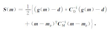
首先在复谱域中构造如公式 (1) 所示目标函数:
|
(1) |
其中g(m) 和d分别为理论和观测数据矢量, 它们的分量相应于不同频率接收函数复谱比, m为模型参数矢量, 角标p表示其先验估计, CD和CM分别为数据和模型的协方差矩阵, *表示复共轭, T表示转置.
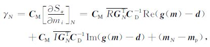
然后利用共轭梯度法求解公式 (1).目标函数梯度可以表示为
|
(2) |
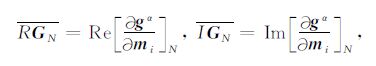
其中
|
(3) |
gα和mi分别是预测数据矢量和模型矢量的分量, 角标N表示第N次迭代的解.
最后经过多次迭代, 选取最佳拟合波形, 得到反演结果.
沿88.5°E获得了台站下方接收函数叠加剖面 (图 3) 显示在Moho不连续界面发生Ps转换震相近乎水平, 这与同剖面实施的深地震反射剖面结果类似 (Gao et al., 2013).这表明, 本文获得的台站下方接收函数结果可靠.

|
图 3 研究剖面AB的地形、台站位置名称以及台站下方叠加接收函数 (a) 剖面地形及台站位置图, 及沿剖面的区域构造特征 (黄继钧, 2001).整个剖面从南到北依次分为南羌塘盆地, 中央隆起, 龙尾错坳陷和白滩湖坳陷; (b) 每个台站的名字及R分量接收函数叠加图. Fig. 3 Surface elevation and stacked receiver function along the profile AB (a) The surface elevation along 88.5°E Profile; (b) Stacked radial receiver function at individual station identified by its name.The profile is divided into South Qiangtang basin, the central metamorphic belt, the Longweicuo depression and Baitanhu depression.Tectonic division is adapted from Huang (2001). |
接收函数复谱比非线性反演 (刘启元等, 1996) 得到27个台站反演结果见图 4.显示所有垂向分量反演结果与实际波形的相关系数都为0.93, 而径向分量的相关系数大都在0.93以上, 表明反演效果较好, 得到一维S波速度模型可靠.

|
图 4 所有27个台站接收函数波形拟合结果 上方波形是垂直分量拟合结果,下方波形是径向分量拟合结果.垂向分量波形反演结果与实际波形相关系数都为0.93, 而径向分量相关系数大都在0.93以上.红色波形是原始波形, 黑色波形是拟合波形. Fig. 4 The result of nonlinear inversion for 27 stations Top waveform is the vertical component.Bottom waveform is the radial component.All vertical waveform modeling correlation coefficient is 0.93.Most radial component waveform modeling correlation coefficient is above 0.93.Red waves are the original receiver function.Black waves are the inversion result. |
沿88.5°E全部27个台站反演得到一维S波速度模型见图 5.根据黄继均 (2001)构造分区, 将研究区域从南到北依次分为南羌塘盆地、中央隆起、北羌塘盆地 (包含了龙尾错坳陷和白滩湖坳陷两个原生沉积坳陷) 三个部分.经过统计, S波速度跳跃较大的位置处S波速度均在4.4 km·s-1(图 5), 因此按照S波速度4.4 km·s-1作为壳幔界面分界 (吴庆举和曾融生, 1998), 图 5显示台站下方Moho面在南羌塘盆地到中央隆起这一区域变化较大, 到北羌塘盆地处Moho面整体从南向北逐渐变浅, 这也与该区域接收函数H-κ叠加分析和CCP (刘国成等, 2014) 和深地震反射Moho起伏特征 (Gao et al., 2013) 相一致 (见图 6b和6c).本文低速层判断方法是用反演得到的速度模型和IASPEI91速度模型比较得到, 本文速度模型如果明显低于IASPEI91速度模型则认为地下存在低速层.图 5中橙色区域表示羌塘盆地下壳内低速层 (Cotte et al., 1999; Rapine et al., 2003; Klemperer, 2006), 南羌塘盆地低速层在地下30 km附近, 在中央隆起以及北羌塘盆地龙尾错坳陷变化不大.北羌塘北部明显变浅.而沿88.5°E剖面下地壳变化较大, 南羌塘下地壳速度较北羌塘下地壳速度偏高, 较接近正常值.而北羌塘下地壳S波速度普遍偏低, 这可能与北羌塘下发生强烈壳幔相互作用导致了岩浆活动有关 (邓万明等, 1996; Hacker et al., 2000; Chung et al., 2005; He et al., 2014).

|
图 5 研究区台站下方S波速度结构 速度模型从上到下依次为南羌塘盆地, 中央隆起, 北羌塘龙尾错坳陷, 北羌塘白滩湖坳陷; 橙色区域表示羌塘盆地内部壳内低速层. Fig. 5 The 1-D S-wave velocity structure underneath the study stations From top to bottom is respectively South Qiangtang basin, the central metamorphic belt, the Longweicuo depression and the Baitanhu depression. The orange areas denote the low velocity layer in the crust. |

|
图 6 沿88.5°E地震观测剖面下地震学结构特征 (a) 台站位置及地形图.空心红三角是台站位置, 实心红三角是温泉位置;(b) 刘国成等 (2014)CCP叠加图.图中蓝色实线表示本文确定的沉积层厚度, 绿色星形表示本文确定的Moho面深度; 蓝色实心圆表示H-κ扫描确定的Moho深度 (刘国成等, 2014); 黄色实线表示深地震反射确定的Moho深度 (Gao et al., 2013);(c) 引自Gao等 (2013)深地震反射剖面.图中蓝色实线是沉积层厚度; 红色椭圆区域是低速层; 绿色星形位置是本文确定的Moho深度; 黄色实线是深地震反射确定的Moho深度. Fig. 6 Seismological tectonic beneath profile longitude 88.5°E (a) show surface elevation and station position along the profile.Red hollow triangles are stations′ location.Red solid triangle is hot spring; (b) Presents combination of CCP stack, H-κ scanning stack (Liu et al.2014) and this study.The blue line delineates the depth of the sedimentary layer, the green stars are the Moho depth from this study.The solid blue circles are the Moho depth calculated by the H-κ stack (Liu et al., 2014).The yellow line is the Moho depth determined by the deep seismic reflection (Gao et al., 2013); (c) show the deep seismic reflection profile (Gao et al., 2013).The blue line delineates the depth of the sedimentary layer.The red ellipses are low velocity layers.The green stars are the Moho depth from this study.The yellow line is the Moho depth determined by the deep seismic reflection (Gao et al., 2013). |
研究区域多种方法得到莫霍面深度比较见图 6.接收函数反演获得Moho深度与H-κ扫描结果 (刘国成等, 2014) 相符, 可以观察到莫霍面整体从南到北由深变浅, 结合CCP叠加结果可以认为反映的莫霍面上分界线位置.
此外, 沉积盆地基底速度参照了深地震反射测定的P波速度5.6 km·s-1(卢占武等, 2006a, 2006b), 本文反演方法计算得到了每个台站下方泊松比, 按照四个区域分别计算出各个区域平均泊松比, 将P波5.6 km·s-1速度转换成S波速度, 根据得到各个台站速度结构标定出各台站下方沉积层厚度.标定沉积基底厚度, 如图 6蓝折线所示.南北羌塘盆地沉积层较厚, 最深处可以达到15 km, 中央隆起处沉积层较薄, 在北羌塘识别出两个沉积坳陷 (龙尾错坳陷和白滩湖坳陷) 也与构造分区 (黄继钧, 2001) 较为一致.综合上述这些特征, 表明利用复谱比共轭梯度非线性反演算法 (刘启元等, 1996) 得到了台站下方一维S波速度结构特征可靠.
4 讨论羌塘盆地位于青藏高原腹部, 是我国最大的中新生代海相沉积盆地, 有良好油气前景 (王成善, 2001).整个盆地被中央隆起带划分成南北羌塘两个盆地 (黄继钧, 2001), 对于中央隆起成因以及盆地基底确定直接影响油气勘探方向.
从20世纪80年代以来, 在羌塘盆地展开了多种地球物理方法勘探.综合地震学深部结构特征 (图 6) 显示88.5°E下壳幔间Moho不连续间断面 (Gao et al., 2013; 刘国成等, 2014) 较为一致.这表明尽管多种地球物理方法获得结果显示羌塘中央隆起带为一深大断裂带 (张胜业等, 1996; 魏文博等, 2006; 贺日政等, 2009; 郑洪伟等, 2012; 邹长桥等, 2012), 且其南北两侧盆地下深部结构具有明显差异 (张胜业等, 1996; Zhao et al., 2001; 魏文博等, 2006; 贺日政等, 2009; 郑洪伟等, 2012; 邹长桥等, 2012; 刘国成等, 2014), 但其向下延深并未穿越整个Moho (见图 6b,6c).这可能是由于古特提斯洋在双湖消减关闭后并未发生强碰撞和深俯冲 (刘国成等, 2014), 且在新生代青藏高原快速整体隆升 (Wang et al., 2014) 所致.
青藏高原地壳中普遍存在低速高导层埋深大概在20 km左右 (Dziewonski et al., 1981; 郑斯华, 1995; Brown et al., 1996; Alsdorf and Nelson, 1999; 张中杰等, 2001; Zhao et al., 2001; Shapiro et al., 2004; 魏文博等, 2006; 贺日政等, 2007).然而, 本文利用致密流动地震观测台网 (图 1) 获得低速层分布 (图 5) 来看, 在羌塘盆地下低速层横向上分布并不连续且埋深也不完全相同.由于北羌塘北部受到了10 Ma以来钾质火山广泛喷发强烈改造 (邓万明等, 1996; Hacker et al., 2000; Chung et al., 2005), 如图 5和图 6c显示北羌塘地体下低速层变化较大, 这与体波层析成像给出整体低速 (邹长桥等, 2012) 一致.南羌塘下低速层仅仅限于台站SQT02之下 (图 6a), 其埋深大概在30 km左右 (图 5), 而该位置所在多玛乡-和平乡北断裂带 (吴珍汉等, 2014) 广泛分布温泉 (图 1).而该区域层析成像图像 (邹长桥等, 2012) 显示该低速区域位于北向俯冲在南羌塘之下拉萨地体顶部.基于这种构造配置关系, 我们推测南羌塘下埋深大概在30 km低速区可能是由拉萨地体北向俯冲过程中脱水形成岩浆房 (Ding et al., 2007).
本次研究获得的一维S波速度结构准确地绘制了北羌塘北部两个大型沉积坳陷, 即如图 6显示龙尾错坳陷和白滩湖坳陷 (王成善, 2001), 这与地表地质特征一致.而龙尾错坳陷由于其南北受到了强烈的逆冲推覆作用 (黄继钧, 2001), 其沉积坳陷严重缩短增厚, 这与石油地质反射剖面探测结果 (卢占武等, 2009) 一致.藏北火山岩空间上分布不均, 在东经88°至91°之间分布密集, 白滩湖坳陷位置正处于多格错仁火山岩分布区 (邓万明等, 1996; Hacker et al., 2000; 王成善, 2001; Chung et al., 2005), 这种强烈的火山作用使得中上地壳发生了强烈的南向逆冲推覆作用 (黄继钧, 2001), 从而使得白滩湖坳陷沉积基底变浅 (李光明, 2000).白滩湖坳陷沉积基底较龙尾错坳陷要浅的多, 大概相差7 km左右.更为重要的是, 35°N以北为一大面积的钾质火成岩区域 (邓万明等, 1996; Hacker et al., 2000; 王成善, 2001; Chung et al., 2005), 其形成时间大致为始新世到中新世 (李光明, 2000), 这与羌塘盆地开始沉积时间接近, 而同时期岩浆热作用会加速两个坳陷内烃源岩中有机质分解和运移 (冯乔和汤锡元, 1997), 因此北羌塘的龙尾错与白滩湖两个沉积坳陷有很好的油气前景.在南羌塘的北缘也存在一个大型的沉积坳陷, 深度大概在15 km左右, 且在其内部有大量油苗分布 (王剑等, 2004), 但由于南羌塘的构造属性存在争议 (王根厚等, 2009), 目前该沉积坳陷尚未引起足够注意.
5 结论本文分析了27个纵跨羌塘盆地中央隆起的流动观测台站, 挑选出了338个远震地震事件的738条远震P波到时数据, 利用接收函数反演方法计算了羌塘盆地内S波一维速度模型.结果显示, 羌塘盆地内Moho面整体南深北浅, 南羌塘南缘下Moho深度为68 km, 羌塘中央隆起带及北羌塘平均深度为60 km左右.南北羌塘盆地地壳速度模型变化上存在明显差异:南羌塘速度大致是正梯度均匀增加, 而局部有限范围内分布的壳内低速层与北向俯冲与拉萨地体有关;而北羌塘速度变化成层状分布, 北羌塘北部下低速层分布深度变化剧烈, 可能与藏北火山岩作用强烈改造有关.南羌塘北缘沉积坳陷沉积厚度最深15 km, 而北羌塘则有两个沉积坳陷, 即龙尾错坳陷具有较厚沉积, 白滩湖坳陷沉积厚度大概在7 km左右, 具有良好的找油前景.
致谢感谢前期野外工作者提供大量原始数据.感谢中国地震局预测研究所王峻博士在接收函数反演方法上无私的帮助.文中部分图件用GMT软件包 (Wessel and Smith, 1998) 绘制而成.
| Alsdorf D, Nelson D. 1999. Tibetan satellite magnetic low:evidence for widespread melt in the Tibetan crust. Geology, 27(10): 943-946. DOI:10.1130/0091-7613(1999)027<0943:TSMLEF>2.3.CO;2 | |
| Ammon C J, Randall G E, Zandt G. 1990. On the nonuniqueness of receiver function inversions. J. Geophys. Res., 95(B10): 15303-15318. DOI:10.1029/JB095iB10p15303 | |
| Ammon C J. 1991. The isolation of receiver effects from teleseismic P wavefronts. Bull. Seismol. Soc. Am., 81(6): 2504-2510. | |
| Ammon C J, Zandt G. 1993. Receiver structure beneath the southern Mojave Block, California. Bull. Seismol. Soc. Am., 83(3): 737-755. | |
| Brown L D, Zhao W J, Nelson K D, et al. 1996. Bright spots, structure, and magmatism in Southern Tibet from INDEPTH seismic reflection profiling. Science, 274(5293): 1688-1690. DOI:10.1126/science.274.5293.1688 | |
| Chen J H, Liu Q Y, Li S C, et al. 2005. Crust and upper mantle S-wave velocity structure across Northeastern Tibetan Plateau and Ordos block. Chinese Journal of Geophysics (in Chinese), 48(2): 333-342. | |
| Chung S L, Chu M F, Zhang Y Q, et al. 2005. Tibetan tectonic evolution inferred from spatial and temporal variations in post-collisional magmatism. Earth-Science Reviews, 68(3-4): 173-196. | |
| Cotte N, Pedersen H, Campillo M, et al. 1999. Determination of the crustal structure in southern Tibet by dispersion and amplitude analysis of Rayleigh waves. Geophysical Journal International, 138(3): 809-819. DOI:10.1046/j.1365-246x.1999.00927.x | |
| Deng W M, Zheng X L, Yukio M. 1996. Petrological characteristics and ages of Cenozoic volcanic rocks from the Hoh Xil Mts. , Qinghai Province. Acta Petrologica Et Mineralogica (in Chinese), 15(4): 289-298. | |
| Ding L, Kapp P, Yue Y H, et al. 2007. Postcollisional calc-alkaline lavas and xenoliths from the southern Qiangtang terrane, central Tibet. Earth and Planetary Science Letters, 254(1-2): 28-38. DOI:10.1016/j.epsl.2006.11.019 | |
| Dziewonski A M, Chou T A, Woodhouse J H. 1981. Determination of earthquake source parameters from waveform data for studies of global and regional seismicity. Journal of Geophysical Research, 86(B4): 2825-2852. DOI:10.1029/JB086iB04p02825 | |
| Feng Q, Tang X Y. 1997. Magma activity's influence on conditions forming oil and gas pools. Geological Science and Technology Information (in Chinese)(4): 59-65. | |
| Fu X G, Wang J, Chen W B, et al. 2010. Age and tectonic implications of the Late Triassic Nadi Kangri volcanic rocks in the Qiangtang basin, northern Tibet, China. Journal of Chengdu University of Technology:Science & Technology Edition (in Chinese), 37(6): 605-615. | |
| Gao R, Lu Z W, Li Q, et al. 2005. Geophysical survey and geodynamic study of crust and upper mantle in the Qinghai-Tibet Plateau. Episodes, 28(4): 263-273. | |
| Gao R, Chen C, Lu Z W, et al. 2013. New constraints on crustal structure and Moho topography in Central Tibet revealed by SinoProbe deep seismic reflection profiling. Tectonophysics, 606: 160-170. DOI:10.1016/j.tecto.2013.08.006 | |
| Gao X, Wang W M, Yao Z X. 2005. Crustal structure of China mainland and its adjacent regions. Chinese J. Geophys. (in Chinese), 48(3): 591-601. | |
| Guo X F, Zhang Y C, Cheng Q Y, et al. 1990. Magnetotelluric studies along Yadong-Golmud geosciences transect in Qinghai-Xizang plateau. Acta Geoscientica Sinica (in Chinese), 11(2): 191-202. | |
| Hacker B R, Gnos E, Ratschbacher L, et al. 2000. Hot and dry deep crustal xenoliths from Tibet. Science, 287(5462): 2463-2466. DOI:10.1126/science.287.5462.2463 | |
| Haines S S, Klemperer S L, Brown L, et al. 2003. INDEPTH III seismic data:From surface observations to deep crustal processes in Tibet. Tectonics, 22(1): 1001. | |
| He R Z, Gao R, Zheng H W, et al. 2007. Matched-filter analysis of aeromagnetic anomaly in mid-western Tibetan Plateau and its tectonic implications. Chinese J. Geophys. (in Chinese), 50(4): 1131-1140. | |
| He R Z, Gao R, Hou H S, et al. 2009. Deep structure of the central uplift belt in the Qiangtang terrane, Tibet Plateau from broadband seismic observations and its implications. Progress in Geophysics (in Chinese), 24(3): 900-908. DOI:10.3969/j.issn.1004-2903.2009.03.012 | |
| He R Z, Liu G C, Golos E, et al. 2014. Isostatic gravity anomaly, lithospheric scale density structure of the northern Tibetan plateau and geodynamic causes for potassic lava eruption in Neogene. Tectonophysics, 628: 218-227. DOI:10.1016/j.tecto.2014.04.047 | |
| Huang J J. 2001. Tectonic characteristics and evolution of the Qiangtang basin. Regional Geology of China (in Chinese), 20(2): 178-186. | |
| Kapp P, Yin A, Manning C E, et al. 2000. Blueschist-bearing metamorphic core complexes in the Qiangtang block reveal deep crustal structure of northern Tibet. Geology, 28(1): 19-22. DOI:10.1130/0091-7613(2000)28<19:BMCCIT>2.0.CO;2 | |
| Kapp P, Yin A, Manning C E, et al. 2003. Tectonic evolution of the early Mesozoic blueschist-bearing Qiangtang metamorphic belt, Central Tibet. Tectonics, 22(4): 1043. | |
| Klemperer S L. 2006. Crustal flow in Tibet:geophysical evidence for the physical state of Tibetan lithosphere, and inferred patterns of active flow. Geological Society, London, Special Publications, 268(1): 39-70. DOI:10.1144/GSL.SP.2006.268.01.03 | |
| Kong X R, Wang Q S, Xiong S B. 1996. Western Tibet Plateau comprehensive geophysical and lithosphere structure study. Science in China (Series D) (in Chinese), 26(4): 308-315. | |
| Langston C A. 1977. Corvallis, Oregon, crustal and upper mantle receiver structure from teleseismic P and S waves. Bull. Seismol. Soc. Am., 67(3): 713-724. | |
| Li C. 1987. The Longmucuo-Shuanghu-Lancangjiang plate suture and the north boundary of distribution of Gondwana Facies Permo-carboniferous system in northern Xizang, China. Journal of Changchun College Geology (in Chinese)(2): 155-166. | |
| Li C, Wang T W, Yang D M, et al. 2001. The lithological composition and tectonic evolution of Qiangtang central uplift region, Tibet. Journal of Changchun University of Science and Technology (in Chinese)(1): 25-31. | |
| Li C. 2008. A review on 20 Years' study of the Longmu Co-Shuanghu-Lancang River Suture Zone in Qianghai-Xizang (Tibet) Plateau. Geological Review (in Chinese), 54(1): 105-119. | |
| Li G M. 2000. Petrologic features and genesis of Cenozoic volcanic rocks, Qiangtang Area, Northern Tibetan Plateau. Geology-Geochemistry (in Chinese), 28(2): 38-44. | |
| Li Y, Liu Q Y, Chen J H, et al. 2007. Shear wave velocity structure of the crust and upper mantle underneath the Tianshan orogenic belt. Science in China Series D:Earth Sciences, 50(3): 321-330. DOI:10.1007/s11430-007-0008-x | |
| Ligorría J P, Ammon C J. 1999. Iterative deconvolution and receiver-function estimation. Bull. Seismol. Soc. Am., 89(5): 1395-1400. | |
| Liu G C, Shang X F, He R Z, et al. 2014. Topography of Moho beneath the central Qiangtang in North Tibet and its geodynamic implication. Chinese J. Geophys. (in Chinese), 57(7): 2043-2053. DOI:10.6038/cjg20140702 | |
| Liu Q Y, Kind R, Li S C. 1996. Maximal likelihood estimation and nonlinear inversion of the complex receiver function spectrum ratio. Chinese J. Geophys. (in Chinese), 39(4): 500-511. | |
| Liu Q Y, Kind R, Li S C. 1997. Receiver functions at the stations of the Chinese digital seismic network (CDSN) and their nonlinear inversion. Acta Geophysica Sinica (in Chinese), 40(3): 356-368. | |
| Liu Q Y, Chen J H, Li S C, et al. 2000. Passive seismic experiment in Xinjiangjiashi strong earthquake region and discussion on its seismic genesis. Chinese J. Geophys. (in Chinese), 43(3): 356-365. | |
| Lu B, Xu K Q, Liu C Y. 2003. Electrical structure of crust in the Qiangtang Region, Northern Tibet and its geological significance. Earth Science Frontiers (in Chinese), 10(S1): 153-159. | |
| Lu Z W, Gao R, Kuang C Y, et al. 2006a. Acquisition technique test of 2-D seismic survey in Qiangtang basin of Tibet. Earth Science Frontiers (in Chinese), 13(5): 382-390. | |
| Lu Z W, Gao R, Xue A M, et al. 2006b. New seismic reflection profiles and basement structure in the Qiangtang basin, northern Tibet. Geology in China (in Chinese), 33(2): 286-290. | |
| Lu Z W, Gao R, Li Q S, et al. 2009. Testing deep seismic reflection profiles across the central uplift of the Qiangtang terrane in the Tibetan Plateau. Chinese J. Geophys. (in Chinese), 52(8): 2008-2014. DOI:10.3969/j.issn.0001-5733.2009.08.008 | |
| Lu Z W, Gao R, Li Y T, et al. 2013. The upper crustal structure of the Qiangtang Basin revealed by seismic reflection data. Tectonophysics, 606: 171-177. DOI:10.1016/j.tecto.2013.07.019 | |
| Ma X B, Kong X R, Yu S. 1997. The western Qinghai Tibet Plateau magnetotelluric exploration results. Chinese Science Bulletin (in Chinese), 42(11): 1185-1187. | |
| Owens T J, Zandt G, Taylor S R. 1984. Seismic evidence for an ancient rift beneath the Cumberland Plateau, Tennessee:A detailed analysis of broadband teleseismic P waveforms. Journal of Geophysical Research, 89(B9): 7783-7795. DOI:10.1029/JB089iB09p07783 | |
| Rapine R, Tilmann F, West M, et al. 2003. Crustal structure of northern and southern Tibet from surface wave dispersion analysis. Journal of Geophysical Research, 108(B2): 2120. | |
| Ross A R, Brown L D, Pananont P, et al. 2004. Deep reflection surveying in central Tibet:lower-crustal layering and crustal flow. Geophysical Journal International, 156(1): 115-128. DOI:10.1111/gji.2004.156.issue-1 | |
| Shapiro N M, Ritzwoller M H, Molnar P, et al. 2004. Thinning and flow of Tibetan crust constrained by seismic anisotropy. Science, 305(5681): 233-236. DOI:10.1126/science.1098276 | |
| Tian X B, Wu Q J, Zhang Z J, et al. 2005. Joint imaging by teleseismic converted and multiple waves and its application in the INDEPTH-III passive seismic array. Geophysical Research Letters, 32(21): L21315. DOI:10.1029/2005GL023686 | |
| Tilmann F, Ni J, INDEPTH III Seismic Team. 2003. Seismic imaging of the downwelling Indian lithosphere beneath Central Tibet. Science, 300(5624): 1424-1427. DOI:10.1126/science.1082777 | |
| Wang C S, Hu C Z, Wu R Z, et al. 1987. Significance of the discovery of Chasang-Chabu rift in Northern Xizang (Tibet). Journal of Chengdu College of Geology (in Chinese), 14(2): 33-46. | |
| Wang C S. Geological Evolution of Qiangtang basin in Tibet and Gas Exploration Prospects (in Chinese).Beijing: Geological Publishing House, 2001. | |
| Wang C S, Dai J G, Zhao X X, et al. 2014. Outward-growth of the Tibetan Plateau during the Cenozoic:A review. Tectonophysics, 621: 1-43. DOI:10.1016/j.tecto.2014.01.036 | |
| Wang G H, Han F L, Yang Y J, et al. 2009. Discovery and geologic significance of Late Paleozoic accretionary complexes in central Qiangtang, northern Tibet, China. Geological Bulletin of China (in Chinese), 28(9): 1181-1187. | |
| Wang J, Tan F W, Li Y L, et al. The Potential of the Oil and Gas Resources in Major Sedimentary Basins on the Qinghai-Xizang (Tibet) Plateau (in Chinese).Beijing: Geological Publishing Housing, 2004. | |
| Wang J, Liu Q Y, Chen J H, et al. 2009. Three-dimensional S-wave velocity structure of the crust and upper mantle beneath the Capital Circle Region from receiver function inversion. Chinese J. Geophys. (in Chinese), 52(10): 2472-2482. DOI:10.3969/j.issn.0001-5733.2009.10.006 | |
| Wang X C, Jia J X, Xu B C. 2008. Gravity/magnetic modeling and geological explanation in Qiangtang Basin geologic aisle. Journal of Jilin University (Earth Science Edition) (in Chinese), 38(4): 685-691. | |
| Wei W B, Jin S, Ye G F, et al. 2006. Conductivity structure of crust and upper mantle beneath the northern Tibetan Plateau:Results of super wide band magnetotelluric sounding. Chinese J. Geophys. (in Chinese), 49(4): 1215-1225. | |
| Wessel P, Smith W H F. 1998. New, improved version of generic mapping tools released. EOS, Transactions American Geophysical Union, 79(47): 579-579. DOI:10.1029/98EO00426 | |
| Wittlinger G, Masson F, Poupinet G, et al. 1996. Seismic tomography of northern Tibet and Kunlun:Evidence for crustal blocks and mantle velocity contrasts. Earth & Planetary Science Letters, 139(1-2): 263-279. | |
| Wittlinger G, Vergne J, Tapponnier P, et al. 2004. Teleseismic imaging of subducting lithosphere and Moho offsets beneath western Tibet. Earth & Planetary Science Letters, 221(1-4): 117-130. | |
| Wu Q J, Zeng R S. 1998. The crustal structure of Qinghai-Xizang Plateau inferred from broadband teleseismic waveform. Acta Geophysica Sinica (in Chinese), 41(5): 669-679. | |
| Wu Z H, Gao R, Lu Z W, et al. 2014. Structures of the Qiangtang Basin and its significance to oil-gas exploration. Acta Geologica Sinica (in Chinese), 88(6): 1130-1144. | |
| Yin F G. 2003. Nature and origin of the central uplift in the Qiangtang Basin. Geotectonica Et Metallogenia (in Chinese), 27(2): 143-146. | |
| Yuan S C, Yu G M, Tian Q N. 2007. Gravity and magnetic anomaly profiles and characteristics of basement structure in the Qiangtang basin, Qinghai-Tibet Plateau. Geological Bulletin of China (in Chinese), 26(6): 703-709. | |
| Zhai Q G, Zhang R Y, Jahn B M, et al. 2011. Triassic eclogites from central Qiangtang, northern Tibet, China:Petrology, geochronology and metamorphic P-T path. Lithos, 125(1-2): 173-189. DOI:10.1016/j.lithos.2011.02.004 | |
| Zhang K J, Zhang Y X, Li B, et al. 2006. The blueschist-bearing Qiangtang metamorphic belt (northern Tibet, China) as an in situ suture zone:Evidence from geochemical comparison with the Jinsa suture. Geology, 34(6): 493-496. DOI:10.1130/G22404.1 | |
| Zhang S Y, Wei S, Wang J Y, et al. 1996. Magnetotelluric sounding in the Qiangtang basin of Xizang (Tibet). Earth Science-Journal of China University of Geosciences (in Chinese), 21(2): 198-202. | |
| Zhang Z J, Li Y K, Wang G J, et al. 2001. E-W crustal structure of North Tibet and "Sunken" Moho an implication from wide-angle reflection profile. Science in China (Series D) (in Chinese), 31(11): 881-888. | |
| Zhao W, Mechie J, Brown L D, et al. 2001. Crustal structure of central Tibet as derived from project INDEPTH wide-angle seismic data. Geophysical Journal International, 145(2): 486-498. DOI:10.1046/j.0956-540x.2001.01402.x | |
| Zhao Z Z, Li Y T, Guo Z J, et al. 1997. Oil and gas exploration prospects for Tibet Plateau. Petroleum Explorationist (in Chinese), 2(3): 14-16. | |
| Zheng H W, Li T D, Gao R, et al. 2007. Teleseismic P-wave tomography evidence for the Indian lithospheric mantle subducting northward beneath the Qiangtang terrane. Chinese J. Geophys. (in Chinese), 50(5): 1418-1426. | |
| Zheng H W, Meng L S, He R Z. 2010. The matched-filter analysis of Bouguer gravity anomaly in Qinghai-Tibet Plateau and its tectonic implications. Geology in China (in Chinese), 37(4): 995-1001. | |
| Zheng H W, He R Z, Yang G. 2012. Geological and geophysical characteristics of Shuanghu-Gangmacuo-Longmucuo structural belt in Qiangtang area. Geology in China (in Chinese), 39(5): 1229-1235. | |
| Zheng S H. 1995. Focal depth of earthquakes under the Tibetan plateau and its tectonic implication. Earthquake Research in China (in Chinese), 11(2): 99-106. | |
| Zou C Q, He R Z, Gao R, et al. 2012. Deep structure of the central uplift belt in the Qiangtang terrane Tibetan Plateaufrom teleseismic P-wave tomography. China Sci. Bull. (in Chinese), 57(28-29): 2729-2739. | |
| 陈九辉, 刘启元, 李顺成, 等. 2005. 青藏高原东北缘-鄂尔多斯地块地壳上地幔S波速度结构. 地球物理学报, 48(2): 333–342. | |
| 邓万明, 郑锡澜, 松本征夫. 1996. 青海可可西里地区新生代火山岩的岩石特征与时代. 岩石矿物学, 15(4): 289–298. | |
| 冯乔, 汤锡元. 1997. 岩浆活动对油气藏形成条件的影响. 地质科技情报(4): 59–65. | |
| 付修根, 王剑, 陈文彬, 等. 2010. 羌塘盆地那底岗日组火山岩地层时代及构造背景. 成都理工大学学报 (自然科学版), 37(6): 605–615. | |
| 高星, 王卫民, 姚振兴. 2005. 中国及邻近地区地壳结构. 地球物理学报, 48(3): 591–601. | |
| 郭新峰, 张元丑, 程庆云, 等. 1990. 青藏高原亚东-格尔木地学断面岩石圈电性研究. 地球学报, 11(2): 191–202. | |
| 贺日政, 高锐, 郑洪伟, 等. 2007. 青藏高原中西部航磁异常的匹配滤波分析与构造意义. 地球物理学报, 50(4): 1131–1140. | |
| 贺日政, 高锐, 侯贺晟, 等. 2009. 羌塘中央隆起带深部结构特征研究及其意义. 地球物理学进展, 24(3): 900–908. DOI:10.3969/j.issn.1004-2903.2009.03.012 | |
| 黄继钧. 2001. 藏北羌塘盆地构造特征及演化. 中国区域地质, 20(2): 178–186. | |
| 孔祥儒, 王谦身, 熊绍柏. 1996. 西藏高原西部综合地球物理与岩石圈结构研究. 中国科学 (D辑:地球科学), 26(4): 308–315. | |
| 李才. 1987. 龙木错-双湖-澜沧江板块缝合带与石炭二叠纪冈瓦纳北界. 长春地质学院学报(2): 155–166. | |
| 李才, 王天武, 杨德明, 等. 2001. 西藏羌塘中央隆起区物质组成与构造演化. 长春科技大学学报(1): 25–31. | |
| 李才. 2008. 青藏高原龙木错-双湖-澜沧江板块缝合带研究二十年. 地质论评, 54(1): 105–119. | |
| 李光明. 2000. 藏北羌塘地区新生代火山岩岩石特征及其成因探讨. 地质地球化学, 28(2): 38–44. | |
| 刘国成, 尚学峰, 贺日政, 等. 2014. 藏北羌塘盆地中部莫霍面形态及其动力学成因. 地球物理学报, 57(7): 2043–2053. DOI:10.6038/cjg20140702 | |
| 刘启元, KindR, 李顺成. 1996. 接收函数复谱比的最大或然性估计及非线性反演. 地球物理学报, 39(4): 500–511. | |
| 刘启元, KindR, 李顺成. 1997. 中国数字地震台网的接收函数及其非线性反演. 地球物理学报(3): 356–368. | |
| 刘启元, 陈九辉, 李顺成, 等. 2000. 新疆伽师强震群区三维地壳上地幔S波速度结构及其地震成因的探讨. 地球物理学报, 43(3): 356–365. | |
| 鲁兵, 徐可强, 刘池阳. 2003. 藏北羌塘地区的地壳电性结构及其意义. 地学前缘, 10(S1): 153–159. | |
| 卢占武, 高锐, 匡朝阳, 等. 2006a. 青藏高原羌塘盆地二维地震数据采集方法试验研究. 地学前缘, 13(5): 382–390. | |
| 卢占武, 高锐, 薛爱民, 等. 2006b. 羌塘盆地石油地震反射新剖面及基底构造浅析. 中国地质, 33(2): 286–290. | |
| 卢占武, 高锐, 李秋生, 等. 2009. 横过青藏高原羌塘地体中央隆起区的深反射地震试验剖面. 地球物理学报, 52(8): 2008–2014. DOI:10.3969/j.issn.0001-5733.2009.08.008 | |
| 马晓冰, 孔祥儒, 于晟. 1997. 青藏高原西部大地电磁测深探测结果. 科学通报, 42(11): 1185–1187. | |
| 王成善, 胡承祖, 吴瑞忠, 等. 1987. 西藏北部查桑-茶布裂谷的发现及其地质意义. 成都地质学院学报, 14(2): 33–46. | |
| 王成善. 西藏羌塘盆地地质演化与油气远景评价.北京: 地质出版社, 2001. | |
| 王根厚, 韩芳林, 杨运军, 等. 2009. 藏北羌塘中部晚古生代增生杂岩的发现及其地质意义. 地质通报, 28(9): 1181–1187. | |
| 王剑, 谭富文, 李亚林, 等. 青藏高原重点沉积盆地油气资源潜力分析.北京: 地质出版社, 2004. | |
| 王峻, 刘启元, 陈九辉, 等. 2009. 根据接收函数反演得到的首都圈地壳上地幔三维S波速度结构. 地球物理学报, 52(10): 2472–2482. DOI:10.3969/j.issn.0001-5733.2009.10.006 | |
| 王喜臣, 贾建秀, 徐宝慈. 2008. 羌塘坳陷石油地质走廊剖面重磁异常处理模拟及地质解释. 吉林大学学报 (地球科学版), 38(4): 685–691. | |
| 魏文博, 金胜, 叶高峰, 等. 2006. 藏北高原地壳及上地幔导电性结构--超宽频带大地电磁测深研究结果. 地球物理学报, 49(4): 1215–1225. | |
| 吴庆举, 曾融生. 1998. 用宽频带远震接收函数研究青藏高原的地壳结构. 地球物理学报, 41(5): 669–679. | |
| 吴珍汉, 高锐, 卢占武, 等. 2014. 羌塘盆地结构构造与油气勘探方向. 地质学报, 88(6): 1130–1144. | |
| 尹福光. 2003. 羌塘盆地中央隆起性质与成因. 大地构造与成矿学, 27(2): 143–146. | |
| 苑守成, 于国明, 田黔宁. 2007. 青藏高原羌塘盆地重磁剖面异常与基底构造特征. 地质通报, 26(6): 703–709. | |
| 张胜业, 魏胜, 王家映, 等. 1996. 西藏羌塘盆地大地电磁测深研究. 地球科学, 21(2): 198–202. | |
| 张中杰, 李英康, 王光杰, 等. 2001. 藏北地壳东西向结构与"下凹"莫霍面-来自宽角反射剖面的启示. 中国科学 (D辑:地球科学), 31(11): 881–888. | |
| 赵政璋, 李永铁, 郭祖军, 等. 1997. 青藏高原油气勘探前景. 勘探家, 2(3): 14–16. | |
| 郑洪伟, 李廷栋, 高锐, 等. 2007. 印度板块岩石圈地幔向北俯冲到羌塘地体之下的远震P波层析成像证据. 地球物理学报, 50(5): 1418–1426. | |
| 郑洪伟, 孟令顺, 贺日政. 2010. 青藏高原布格重力异常匹配滤波分析及其构造意义. 中国地质, 37(4): 995–1001. | |
| 郑洪伟, 贺日政, 杨贵. 2012. 羌塘地体内部双湖-冈玛错-龙木错构造带地质与地球物理特征. 中国地质, 39(5): 1229–1235. | |
| 郑斯华. 1995. 青藏高原地震的震源深度及其构造意义. 中国地震, 11(2): 99–106. | |
| 邹长桥, 贺日政, 高锐, 等. 2012. 远震P波层析成像研究羌塘中央隆起带深部结构. 科学通报, 57(28-29): 2729–2739. | |