 2016, Vol. 59


2. 中国科学院大学, 北京 100049;
3. 中国地震局地壳应力研究所(地壳动力学重点实验室), 北京 100085
2. University of Chinese Academy of Sciences, Beijing 100049, China;
3. Key laboratory of Crustal Dynamic, Institute of Crustal Dynamics, Beijing 100085, China
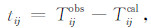
克拉通在太古代与早元古代时期形成,是地球上相对稳定的构造单元,如南非卡普瓦尔克拉通、俄罗斯西伯利亚克拉通和加拿大北美克拉通等,其下 方存在250~300 km的大陆根(Polet and Anderson,1995; Artemieva and Mooney,2001; James et al.,2001).华北克拉通(图 1)有着36亿年古老地壳(Liu et al.,1992),在晚太古代和古元古代时期,华北克拉通经历了一系列构造演化过程(Zhai et al.,2001),但在东西克拉通碰撞之后的晚元古代变得较为稳定(Zhao et al.,2000),直至中奥陶纪构造与岩浆活动才平静(Lu et al.,2000).然而,华北克拉通在晚中生代又开始复活.从空间构造的角度来说,华北克拉通由东向西依次可划分为东、中、西克拉通,东克拉通以华北盆地为主,中克拉通以山西地堑和太行山造山带为主,而西克拉通以鄂尔多斯盆地为主.东克拉通地区当前研究较多,为认 识克拉通破坏机制提供了很多有意义证据(Fan and Menzies,1992; Menzies et al.,1993;刘福田等,1996;Xu,2001,2002; Gao et al.,2002;段永红等,2002; 嘉世旭等,2005; Lei et al.,2008,2011; Wu et al.,2008; Huang et al.,2009; Tian et al.,2009; Chen et al.,2010; 吕作勇等,2010; 朱日祥等,2011; Lei,2012; 杨婷等,2012; Zhao et al.,2012; 王炳瑜等,2013; 刘志等,2015),而西克拉通地区的鄂尔多斯盆地深部结构与深层动力过程的研究却较少.鄂尔多斯盆地以北有河套地堑和阴山—燕山造山带,以南有汾渭地堑和秦岭—大别—苏鲁造山带,以西有银川地堑,以东有山西地堑和太行山造山带.尽管有研究者对包括鄂尔多斯盆地在内的华北克拉通开展过相关研究(Huang et al.,2009; Tian et al.,2009; Lei,2012; Wang et al.,2013),但这些工作主要为利用鄂尔多斯盆地周边台站记录到周边地震的到时资料来反演其下方深部结构,因此其模型的空间分辨率较为有限,主要是鄂尔多斯盆地缺少地震台站分布所致.为此,北京大学、中国地震局地球物理研究所和中国科学院地质与地球物理研究所分别在鄂尔多斯盆地内部及周边地区开展了密集流动地震观测,且获得了研究区地壳上地幔结构相关研究成果(Zheng et al.,2009; Chen et al.,2009,2014; Zhao and Xue,2010; Wei et al.,2011;Zhao et al.,2012; Yu et al.,2012; Wang et al.,2014).

|
图 1 研究区构造背景和台站分布 黑色线段代表主要构造线,灰色线段代表活动断层,红色三角形代表第一期布设的流动台站,黄色三角形代表第二期布设的流动台站,蓝色三角形代表第三期布设的流动台站. 蓝色线(110.5°E)代表图5剖面位置 Fig. 1 The tectonic background of the study area and the distribution of seismic stations The black lines represent major active tectonic lines, whereas the gray lines represent active faults. The red triangles represent the portable stations at the first stage, the yellow triangles represent the portable stations at the second stage, whereas the blue triangles represent the portable stations at the third stage. |
为深入认识鄂尔多斯盆地、河套地堑和阴山造山带之间深部构造关联性和华北克拉通破坏减薄机理,中国科学院地质与地球物理研究所2006—2008年期间在110°E附近的37°N~43°N之间的鄂尔多斯盆地、河套地堑和阴山造山带地区布设了高密度线性流动地震观测台阵(图 1),这些资料已被应用于研究鄂尔多斯盆地北缘地壳上地幔速度与间断面结构(滕吉文等,2008,2010; Tian et al.,2011),为认识华北克拉通破坏提供有意义的地震学证据.这种线性台阵资料在青藏高原及周边和华北等其它地区的上地幔成像方面获得了有意义的研究结果(Wittlinger et al.,1996; 郭飚等,2004; Chen et al.,2009,2014; Zhao and Xue,2010; Bai et al.,2011; Hung et al.,2011; Zhao et al.,2012; Yu et al.,2012; 刘震等,2015). 本研究拟利用中国科学院地质与地球物理研究所2006—2008年期间在110°E附近的高密度流动地震观测记录到的远震数据,采用FMTT(Fast Marching Teleseismic Tomography;Rawlinson et al.,2004)快速行进层析成像方法对鄂尔多斯盆地北部边缘(32°N—44°N,105°E—115°E)的深部P波速度结构进行成像反演,以对华北克拉通形成演化与破坏减薄等动力过程提供重要的地震学证据.
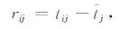
2 资料与方法 2.1 资料本文采用的资料是中国科学院地质与地球物理研究所2006年至2008年期间在鄂尔多斯盆地北缘 开展的宽频带流动观测(图 1)记录到的远震波形资料.该流动地震观测分为三期,每期台址位置均不相同,但沿110°E同一测线由37°N开始向北依次流动观测至43°N.第一期为2006年10月—2007年4月,台站数为20个,在图 1中显示为红色三角;第二期为2007年5月—2007年11月,台站数为20个,在图 1中用黄色三角表示;第三期为2007年12月—2008年4月,台站数为14个,在图 1中用蓝色三角表示.为了保证远震数据的质量,本研究对三期台站观测记录到的震级MW≥5.3且震中距大于30°但小于90°的远震事件波形数据进行详细筛选,挑选出具有良好信噪比和明显初至的波形,保证每个事件至少被5个台站记录,最终得到215个远震事件(图 2)记录到的1985条高质量到时资料.从远震震中分布来看,事件主要分布在西太平洋俯冲带地区,在地中海、红海等地区也有分布,说明本研究所选地震事件围绕研究区具有较好空间方位覆盖,对于求解研究区成像结果具有重要作用.

|
图 2 研究区所用的远震震中(黄色菱形)分布 红色三角代表台网中心 Fig. 2 The distribution of teleseismic epicenters (yellow diamonds)used in this study. The red triangle represents the center of the seismic network. |
为避免模型外结构和震源参数的不确定性对成像结果的影响,本文利用远震相对走时残差对研究区进行成像反演.本研究中,我们采用如Lei and Zhao(2005)手工方式直接从远震波形上拾取到时资料,获得1985条高质量远震到时资料,然后采用ak135全球一维速度模型(Kennett et al.,1995)计算理论走时.根据Zhao et al.(1994),相对走时残差定义如下:走时残差tij是观测走时Tijobs与理论走时Tijcal之差,即
|
(1) |
而相对走时残差rij是走时残差tij减去事件的平均残差tj,即
|
(2) |
其中tj为第j个事件被mj个台站所记录的平均走时残差.即
|
(3) |
同一台站记录到的所有事件相对走时残差做平均,即可得到每个台站相对走时残差.
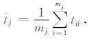
由于本研究计算主要采用ak135模型计算理论走时,因而需要进行地壳校正,以避免地壳结构影响到地幔结构成像.本研究采用Crust 1.0模型(Laske et al.,2013)进行了地壳校正,校正后的台站的平均相对走时残差如图 3所示.由图 3可以看出,鄂尔多斯盆地地震台站基本为负残差且较大,说明其下方上地幔可能存在高波速异常,而河套地堑台站为正残差也较大,说明其下方上地幔可能存在低波速异常.阴山造山带地震台站的残差,既表现有正残差又表现有负残差,但其量值均较小且以负残差为主,说明该区下方上地幔可能存在弱高波速异常.根据Lei and Zhao(2007)通过多种地壳速度模型对天山造山带台站记录到的远震走时校正后的地幔结果进行对比分析,发现不同地壳校正获得的地幔成像结果仅在异常细节上有差别,而不存在异常模式上的差别.因此,本研究采用Crust 1.0模型(Laske et al.,2013)修正走时后获得的上地幔结果不会影响到我们对华北克拉通破坏机制的理解.

|
图 3 每个台站的平均相对走时残差 蓝色和红色圆圈分别为负正残差,圆圈大小代表残差大小. Fig. 3 Average relative residuals at each station Blue and red circles denote negative and positive residuals, respectively, and the sizes of circles denote the amount of residuals. |
本研究利用上述方法获得的相对走时残差,采用FMTT(Fast Marching Teleseimic Tomography)快速行进法(Rawlinson et al.,2004)进行远震层析成像,包括正演计算和反演计算.其中,正演计算采用快速行进法(Fast Marching Method)(Sethian et al.,1999; Rawlinson et al.,2004)进行射线追踪计算走时和射线路径,反演采用子空间反演方法(Oldenburg et al.,1993; Oldenburg et al.,1994).
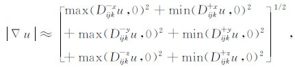
快速行进法的正演计算是通过迎风有限差分格式求解程函方程,利用窄带模拟波前的传播过程,进而求解研究区的走时值.三维情况下的程函方程可表示为(Sethian et al.,1999):
|
(4) |
其中,u(x,y,z)和s(x,y,z)分别表示三维模型中的走时场和慢度场.
根据迎风有限差分格式,可将上述程函方程写成(Sethian et al.,1999)
|
(5) |
其中,D-x,D-y,D-z分别表示在x,y,z方向上的向前有限差分算子,D+x,D+y,D+z分别表示在x,y,z方向上的向后有限差分算子.
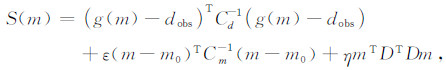
子空间反演法的目标函数(Rawlinson et al.,2006)定义:
|
(6) |
其中,g(m)表示理论走时残差,dobs表示观测走时残差,m表示反演模型,m0表示参考模型,ε表示阻尼因子,η表示平滑因子.在模型约束的情况下,使理论走时残差不断逼近观测走时残差,以达最终获得较为合理的模型值.通过FMTT方法能够有效解决研究区速度结构和界面复杂的情况,且高效稳定地获得最终速度模型.这种方法已在我国大陆成像工作中得到应用(张风雪等,2011,2013).
3 结果 3.1 模型参数化本研究的模型参数化范围在水平方向上为32°N—44°N,105°E—115°E,在深度范围为-2~698 km.通 过大量检测板分辨率测试,认为在水平方向反演所用网格大小可采用1°,而在深度方向网格大小可采 用50 km.初始速度模型采用ak135(Kennett et al.,1995).
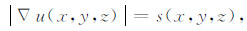
3.2 阻尼因子和平滑因子测试本文采用子空间反演方法进行反演,其中阻尼因子和平滑因子控制了数据的收敛程度和模型的平滑程度.因此,为了获得更为合理的成像结果,在对研究区进行层析成像工作之前,需要进行阻尼因子和平滑因子的测试.首先,固定阻尼因子为1,而平滑因子在变化情况下进行测试,绘制出数据方差和模型平滑程度的折中曲线(图 4a),可以看出选择平滑因子为100时既能保证模型光滑又能保证残差较小,因此阻尼因子为1时平滑因子的最佳值为100.然后,固定平滑因子为100,通过改变阻尼因子可绘制数据方差和模型方差的折中曲线(图 4b),可以看出阻尼因子的最佳值为40.最后,固定阻尼因子为40,通过改变平滑因子的大小再获得了数据方差和模型方差的折中曲线(图 4c),可以看出平滑因子最佳值仍为100.通过以上反复测试,最终确定最佳阻 尼因子和平滑因子分别为40和100.这对参数不仅可以使数据残差得到有效收敛,而且能在一定程度上控制模型的平滑程度.因此,本文采用阻尼因子40和平滑因子100进行反演.

|
图 4 阻尼因子和平滑因子测试图 (a) 固定阻尼因子ε为1但改变平滑因子η后,走时方差和模型平滑程度的折中曲线;(b) 固定平滑因子η为100但改变阻尼因子ε后,走时方差和模型方差的折中曲线;(c) 固定阻尼因子ε为40但改变平滑因子η后,走时方差和模型平滑程度的折中曲线. Fig. 4 The tests for damping and smoothing factors (a) The trade-off curve between data variance and model roughness with the damping factor of 1 and a variation of smoothing factor; (b) The trade-off curve between data variance and model variance with the smoothing factor of 100 and a variation of damping factor; (c) The trade-off curve between data variance and model roughness with the damping factor of 40 and a variation of smoothing factor. |
为了检验当前资料(图 5a)下研究区模型的空间分辨率,本文通过改变网格大小,开展了大量检测板实验.由于篇幅的原因,本文仅展示出一个检测板实验结果.该实验中,在水平方向上设定东西向波速异常网格间距为4°,南北向波速异常网格间距为2°,在深度方向设定波速异常网格间距为200 km,相邻网格内的速度设定为相对于初始速度模型交替扰动±0.2 km·s-1(图 5b),以此模型计算的走时作为观测走时.然后,再在无速度扰动的一维模型下,计算相同地震与台站的走时,以两者之相对走时残差作为资料进行9次迭代反演.图 5c展示了该检测板实验结果,可以看出所用资料能够在一定程度上恢复台站下方深至300 km的速度扰动,这可能由于射线再往深处处于发散状态和射线交叉性降低有关(图 5a).因此,以下主要围绕沿37°N—42°N深至300 km范围内的波速异常结果来讨论问题.

|
图 5 (a) 射线纵剖面示意图; (b) 检测板输入模型; (c) 检测板输出模型;(d) 实际资料反演结果(c)和(d)中的方框表示结果可靠区. Fig. 5 (a) The distribution of seismic rays along the profile; (b) Input model of the checkerboard resolution test; (c) Output model of the checkerboard resolution test; (d) Inverted results from observational data The boxes in (c) and (d) show the reliable areas of our results. |
本研究利用校正后的走时残差(图 3),通过FMTT方法进行层析成像反演,选取阻尼因子为40,平滑因子为100,迭代9次后走时残差减小到较为稳定状态,停止迭代后获得最终速度模型(图 5d).可以看出,研究区下方速度存在强烈横向不均匀性.鄂尔多斯盆地下方存在深至200 km的高波 速异常,河套地堑下方存在向鄂尔多斯盆地下方倾斜的低波速异常,且延伸至300 km或更深.阴山造山带下方存在深至100 km左右的弱高波速异常.这些结构特征已被检测板实验结果(图 5b和图 5c)所证实.
4 讨论 4.1 与前人结果的对比前人利用不同地震台站资料对围绕鄂尔多斯盆地开展过大量研究工作,譬如Tian et al.(2009)、Lei(2012)和Wang et al.(2014)利用鄂尔多斯盆地周边省级固定地震台站资料对鄂尔多斯盆地岩石圈速度结构进行过研究,而Zhao et al.(2012)将流动台站与固定台站相结合对鄂尔多斯盆地及周边地区开展速度成像研究.Chen(2010)和Tian et al.(2011)分别利用不同高密度流动地震观测开展过鄂尔多斯盆地岩石圈底界面研究.尽管这些研究与本研究所用的资料与方法均存在有一定不同之处,但研究结果还存在一定类似.本研究结果显示鄂尔多斯盆地北缘河套地堑其下方存在明显低波速异常,与前人的研究速度成像结果(Tian et al.,2009; Lei,2012; Zhao et al.,2012; 李多等,2012; Wang et al.,2014)和接收函数成像结果(Chen,2010; Tian et al.,2011)相一致.然而,本研究结果揭示出鄂尔多斯盆地岩石圈厚度仅约200 km且由南向北逐渐减薄的新的结构特征,得到接收函数研究结果(Chen,2010; Tian et al.,2011)的支持,也得到检测板实验结果(图 5b和图 5c)的证实.因此,相对来说于前人成像结果显示的鄂尔多斯盆地下方上地幔 为一个整体连续的高波速异常且延伸至300~400 km 深度(Tian et al.,2009; Lei,2012; Zhao et al.,2012; Wang et al.,2014; 郭慧丽等,2014)的结果,本研究结果有明显改进.
4.2 构造意义华北克拉通西部鄂尔多斯盆地下方上地幔整体 上呈现明显高波速异常(图 5d),且延伸至150~200 km 深度,且该高波速异常具有由南向北逐渐变薄的变化特征(图 5d).另外,阴山造山带或河套盆地下方显示出明显低波速异常,且该波速异常向鄂尔多斯盆地下方延伸(图 5d).如果鄂尔多斯盆地下方的高波速异常代表岩石圈结构、阴山造山带或河套盆地下方的低波速异常代表热物质上涌,那么我们的研究结果可能反映鄂尔多斯块体岩石圈尽管没遭到破坏减薄,但仍受到阴山造山带或河套盆地下方上涌热物质的影响.结合前人研究结果(Lei et al.,2005,2006; Huang and Zhao,2006; Li et al.,2010; Lei,2012),认为太平洋板块在地幔转换带内可能俯冲至太行山重力梯度带附近,说明鄂尔多斯盆地岩石圈地幔受太平洋板块深俯冲引起的软流圈热流上涌(Lei,2012)等周边构造环境影响有关,得到接收函数研究结果(Tian et al.,2011)的支持.
如果本研究结果显示华北克拉通西部鄂尔多斯盆地岩石圈厚度达150~200 km左右,而华北克拉通东部的岩石圈厚度仅约60~80 km(Chen et al.,2010),则表明华北克拉通东部的岩石圈在华北克拉通活化过程中发生大规模破坏,并造成岩石圈减薄,而鄂尔多斯盆地下方的岩石圈结构稳定,未造成大规模的破坏,目前还属于克拉通型岩石圈,这也得到鄂尔多斯盆地的热流值较低(胡圣标等,2001)和布格重力异常也较低(张永谦等,2013)等研究结果的支持.
5 结论本文利用布设于鄂尔多斯盆地北缘的宽频带流动台站记录的高质量远震数据进行FMTT层析成像,获得了该区上地幔P波三维速度结构.结果显示,研究区P波速度分布存在强烈横向不均匀性.鄂尔多斯盆地呈现出深达150~200 km深度的高波速异常,且由南向北逐渐变浅,河套地堑下方存在深达300 km左右低波速异常,并倾向于鄂尔多斯盆地下方,说明华北克拉通在构造运动过程中,由于受太平洋板块由东向西深俯冲作用,不同块体经历了不同构造演化过程.华北克拉通东部的岩石圈受到了相应的破坏而减薄,而华北克拉通西部鄂尔多斯盆地的岩石圈结构仍较为稳定,未受到大规模的破坏.这些结果对于理解华北克拉通破坏减薄和其不均匀展布的界域与深层动力学确具有重要意义.
致谢感谢参与野外流动地震观测所有成员,感谢田小波研究员为本文提供处理后的远震波形数据,感谢张广伟和周智刚在程序调试方面给予的帮助.
| Artemieva I M, Mooney W D. 2001. Thermal thickness and evolutionof Precambrian lithosphere: A global study. J. Geophys. Res. , 106: 16,387-16–414. | |
| Bai Z M, Tian X B, Tian Y. 2011. Upper mantle P-wave tomography across the Longmenshan fault belt from passive-source seismic observations along Aba-Longquanshan profile. J. Asian Earth Sci. , 40: 873–882. | |
| Chen L, Cheng C, Wei Z G. 2009. Seismic evidence for significant lateral variations in lithospheric thickness beneath the central and western North China Craton. Earth Planet. Sci. Lett. , 286: 171–183. | |
| Chen L. 2010. Concordant structure variations from the surface to thebase of the upper mantle in the North China Craton and its tectonic implications. Lithos , 120: 96–115. | |
| Chen L, Jiang M M, Yang J H, Wei Z G, Liu C Z, Ling Y. 2014. Presence of an intralithospheric discontinuity in the central and western North China Craton: Implications for destruction of the craton. Geology , 42: 223–226. | |
| Chen L H, Song Z H. 1990. Crust-upper Mantle P wave velocity structure beneath Northern China. Chinese J. Geophys. (in Chinese) , 33(5): 540–546. | |
| Duan Y H, Zhang Y K, Fang S M. 2002. Three-dimensional finite-difference tomography of velocity structure of the upper crustal in North China. Chinese J.Geophys. (in Chinese) , 45(3): 362–369. | |
| Fan W, Menzies A. 1992. Destruction of aged lower lithosphere andaccreation of asthenosphere mantle beneath eastern China. Geotectonica Metallogenia , 16: 171–180. | |
| Gao S, Rudnick R, Carlson R, McDonough W, Liu Y. 2002. Re-Os evidence for replacement of ancient mantle lithosphere beneaththe North China craton. Earth Planet. Sci. Lett. , 198: 307–322. | |
| Guo B, Liu Q Y, Chen J H, et al. 2004. Seismic tomography imaging of the crust and upper mantle beneath the Northern edge of the Qinghai-Xizang plateau and the Ordos area. Chinese J.Geophys. (in Chinese) , 47(5): 790–797. | |
| Guo H L, Xu P F, Zhang F Q. 2014. P wave velocity structure of the North China Craton and West Pacific active continental margin: exploration for dynamic processes of lithosphere thinning China. . Chinese J.Geophys. (in Chinese) , 57(7): 2352–2361. | |
| Hu S B, He L J, Wang J Y. 2001. Complation of heat flow data in the China continental area(3rd edition). Chinese J.Geophys. (in Chinese) , 44(5): 610–625. | |
| Huang J L, Zhao D P. 2006. High-resolution mantle tomography of China and surrounding regions. J. Geophys. Res. , 111: B09305. | |
| Huang Z X, Li H Y, Zheng Y J, et al. 2009. The lithosphere of North China Craton from surface wave tomography. Earth Planet. Sci. Lett. , 288(1-2): 164–173. | |
| Hung S, Chen W P, Chiao L Y. 2011. A data-adaptive, multiscale approach of finite-frequency, traveltime tomography with special reference to P and S wave data from central Tibet. J. Geophys. Res. , 116: B06307. | |
| James D E, Fouch M J, VanDecar J C, VanDer Lee S. 2001. the Kaapvaal Seismic Group. 2001. Tectospheric structure beneath southern Africa. Geophys. Res. Lett. , 28: 2485–2488. | |
| Jia S X, Zhang X K. 2005. Crustal structure and comparison of different tectonic blocks in North China. Chinese J. Geophys. (in Chinese) , 48(3): 611–620. | |
| Kennett B L N, Engdahl E R, Buland R. 1995. Constraints on seismic velocities in the earth from travel times. Geophys. J. Int. , 122: 108–124. | |
| Laske G., Masters G., Ma Z., Pasyanos M.. 2013. Update on CRUST1.0-A 1-degree Global Model of Earth's Crust. Geophys. Res. Abstracts , 15: EGU2013–2658. | |
| Lei J S, Zhao D P. 2005. P-wave tomography and origin of the Changbai intraplate volcano in Northeast Asia. Tectonophysics , 397: 281–295. | |
| Lei J S, Zhao D P. 2006. Global P-wave tomography: On the effect of various mantle and core phases. Phys. Earth Planet. Inter. , 154: 44–69. | |
| Lei J S, Zhao D P. 2007. Teleseismic P-wave tomography and the upper mantle structure of the central Tien Shan orogenic belt. Phys. Earth Planet. Inter. , 162: 165–185. | |
| Lei J S, Xie F R, Lan C X, Xing C Q, Ma S Z. 2008. Seismic images under the Beijing region inferred from P and PmP data. Phys. Earth Planet. Inter. , 168: 134–146. | |
| Lei J S, Zhao D P, Xie F R, Liu J. 2011. An attempt to detect temporal variations of crustal structure in the source area of the 2006 Wen-An earthquake in North China. J. Asian Earth Sci. , 40: 958–976. | |
| Lei J S. 2012. Upper-mantle tomography and dynamics beneath the North China Craton. J. Geophys. Res. , 117: B06313. | |
| Lei J S, Xie F R, Fan Q C, Santosh M. 2013. Seismic imaging of the deep structure under the Chinese volcanoes: An overview. Phys. Earth Planet. Inter. , 224: 104–123. | |
| Li C, vander Hilst R D. 2010. Structure of the upper mantle and transition zone beneath Southeast Asia from travel time tomography. J. Geophys. Res. , 115: B07308. | |
| Li D, Zhou S Y, Chen Y S, et al. 2012. 3-D lithospheric structure of upper mantle beneath Ordos region from Rayleigh-wave tomography. Chinese J. Geophys. (in Chinese) , 55(5): 1613–1623. | |
| Liu D, Nutnam A, Compston W, Wu J, Shen Q. 1992. Remnants of >3800 Ma crust in the Chinese part of the Sino-Korean Craton. Geology , 20: 339–342. | |
| Liu F T, Qu K X, Wu H, et al. 1996. Seismic tomography of North China region. Chinese J. Geophys. (in Chinese) , 29(5): 443–448. | |
| Liu Z, Tian X B, Liang X F, et al. 2015. Upper mantle structure beneath central Tibet derived from teleseismic S wave tomography along the INDEPTH-III profile. Chinese J. Geophys. , 58(4): 1169–1178. doi: 10.6038/cjg20150407. | |
| Liu Z, Wang F Y, Zhang X K, et al. 2015. Seismic of the lithosphere beneath Eastern North China Craton: results from long distance deep seismic sounding. Chinese J. Geophys. (in Chinese) , 58(4): 1145–1157. | |
| Lü Z Y, Wu J P. 2010. 3D P wave velocity structure of crust and upper mantle beneath North China. Acta Seismol. Sinica (in Chinese) , 32(1): 1–11. | |
| Lu F, Zheng J, Li W, Chen M, Chen Z. 2000. The mantle evolutionpattern of Phanerozoic mantle in the eastern China: The mushroom cloud model. Geosci. Frontier , 7: 97–107. | |
| Menzies M, Fan W, Zhang M. 1993. Palaeozoic and Cenozoiclithoprobes and loss of >120 km of Archean lithosphere, Sino-Koreancraton, China. Geol. Soc. Spec. Publ. , 76: 71–81. | |
| Oldenburg D W, McGillivray P R, Ellis R G. 1993. Generalized subspace methods for large-scaleinverse problems. Geophys. J. Int. , 114: 12–20. | |
| Oldenburg D W, Li Y G. 1994. Subspace linear inverse method. Inverse Problem , 10: 915–935. | |
| Polet J, Anderson D L. 1995. Depth extent of craton as inferred from tomographic studies. Geology , 23: 205–208. | |
| Rawlinson N, Kennett B LN. 2004. Rapid estimation of relative and absolute delay times across a network by adaptive stacking. Geophys. J. Int. , 157: 332–340. | |
| Rawlinson N, Sambridge M. 2004. Wave front evolution in strongly heterogeneous layered mediausing the fast marching method. Geophys. J. Int. , 156: 631–647. | |
| Rawlinson N, Reading A M, Kennett B L N. 2006. Lithospheric structure of Tasmania from a novel form of teleseismic tomography. J. Geophys. Res. , 111: B02301. | |
| Sethian J, Popovici A, Mihai A. 1999. 3-D traveltime computation using the fast marching method. Geophysics , 64(2): 516–523. | |
| Teng J W, Wang F Y, Zhao W Z, et al. 2008. Velocity distribution of upper crust, undulation of sedimentary formation andcrystalline basement beneath the Ordos basin in North China. Chinese J. Geophys. (in Chinese) , 2008: 1753–1766. | |
| Teng J W, Wang F Y, Zhao W Z, et al. 2010. Velocity structure of layered block and deep dynamic process in the lithosphere beneath the Yinshan orogenic belt and Ordos Basin. Chinese J. Geophys. , 53(1): 67–85. doi: 10.3969/j.issn.0001-5733.2010.01.008. | |
| Tian Y, Zhao D P, Sun R M, et al. 2009. Seismic imaging of the crust and upper mantle beneath the North China Craton. Phys. Earth Planet. Inter. , 172(3-4): 169–182. | |
| Tian X B, Teng J W, Zhang H S, Zhang Z J, Zhang Y Q, Yang H, Zhang K K. 2011. Structure of crust and upper mantle beneath the Ordos block and the Yinshanmountains revealed by receiver function analysis. Phys. Earth Planet. Inter. , 184: 186–193. | |
| Wang B Y, Chen L, Ai Y S, et al. 2013. Crustal structure and mantle transition zone thickness beneath the northeastern area of the North China Craton and adjacent region. Chinese J.Geophys. (in Chinese) , 56(1): 60–68. | |
| Wang C Y, Sandvol E, Zh uL, et al. 2014. Lateral variation of crustal structure in the Ordos block and surrounding regions, North China, and its tectonic implications. Earth Planet. Sci. Lett. , 387: 198–211. | |
| Wang J, Zhao D P, Yao Z X. 2013. Crustal and uppermost mantle structure and seismotectonics of North China Craton. Tectonophysics , 582: 177–187. | |
| Wang J, Hu H, Zhao D. 2014. P wave radial anisotropy tomography of the upper mantle beneath the North China Craton. Geochem. Geophys. Geosyst. , 15: 2195–2210. | |
| Wei Z, Chen L, Xu W. 2011. Crustal thickness and Vp/Vs ratio of the central and western North China Craton and its tectonic implications. Geophys. J. Int. , 186: 385–389. | |
| Wittlinger G, Masson F, Poupinet G, et al. 1996. Seismic tomography of northern Tibet and Kunlun: Evidence for crustal blocks and mantle velocity contrasts. Earth Planet. Sci. Lett. , 139: 263–279. | |
| Wu F, Zhang Y, Yang J, Xie L, Yang Y. 2008. Zircon U-Pb and Hf isotopic constraints on the early Archean crustal evolution inAnshan of the North China Craton. Precambrian Res. , 167: 339–362. | |
| Xu Y. 2001. Thermo-tectonic destruction of the Archean lithospheric keel beneath the Sino-Korean craton in China: Evidence, timing and mechanism. Phys. Chem. Earth , 26: 747–757. | |
| Xu Y. 2002. Mantle plumes, large igneous provinces and their geological consequences. Earth Sci. Front. , 9: 341–353. | |
| Yang T, Wu J P, Fang L H, et al. 2012. 3-D S-wave velocity structure of crust and upper mantle beneath North China. Prog. Geophys. , 27(2): 0441–0454. doi: 10.6038/j.issn.1004-2903.2012.02.007. | |
| Yu C Q, Chen W P, Ning J Y, et al. 2012. Thick crust beneath the Ordos plateau: Implications for instability of the North China Craton. Earth Planet. Sci. Lett. , 357-358: 366–375. | |
| Zhai M, Guo J, Liu W. 2001. An exposed cross-section of early Precambrian continental lower crust in North China Craton. Phys. Chem. Earth , 26: 781–792. | |
| Zhao G C, Cawood P, Wilde S, Sun M, Lu L. 2000. Metamorphismof basement rocks in the central zone of the North China Craton: Implications for Paleoproterozoic tectonic evolution. Precambrian Res. , 103: 55–88. | |
| Zhao D P, Hasegawa A, Kanamori H. 1994. Deep structure of Japan subductionzone as derived from local, regional and teleseismic events. J. Geophys. Res. , 99(B11): 22313–22329. | |
| Zhao L, Xue M. 2010. Mantle flow pattern and geodynamic cause of the North China Craton reactivation: Evidence from seismic anisotropy. Geochem. Geophys. Geosyst. , 11. doi: 10.1029/2010GC003068. | |
| Zhao L, Allen R, Zheng T, Zhu R. 2012. High-resolution body wave tomography models of the upper mantle beneath eastern China and the adjacent areas. Geochem. Geophys. Geosyst. , 13: Q06007. | |
| Zang S X, Liu Y G, Ning J Y. 2002. Thermal structure of the lithosphere in North China. Chinese J. Geophys. (in Chinese) , 45(1): 56–66. | |
| Zhang Y Q, Teng J W, Wang Q S, et al. 2013. Crustal structure and the geodynamic process beneath the Hetao basin and adjacent area. Progress in Geophys. , 28(5): 2264–2272. doi: 10.6038/pg20130508. | |
| Zhang F X, Li Y H, Wu Q J, et al. 2011. The P wave velocity structure of upper mantle beneath the North China and surrounding regions from FMTT. Chinese J. Geophys. (in Chinese) , 54(5): 1233–1242. | |
| Zhang F X, Wu Q J, Li Y H. 2013. The traveltime tomography study by teleseismic P wave data in the Northeast China area. Chinese J. Geophys. , 56(8): 2690–2700. doi: 10.6038/cjg20130818. | |
| Zheng T Y, Zhao L, Zhu R X. 2009. New evidence from seismic imaging for subduction during assembly of the North China craton. Geology , 37: 395–398. | |
| Zhu R, ChenL, W uF, Liu J. 2011. Timing, scale and mechanismof the destruction of the North China Craton. Sci. China Earth Sci. (in Chinese) , 54: 789–797. | |
| 陈立华, 宋仲和. 1990. 华北地区地壳上地幔P波速度结构. 地球物理学报 , 33(5): 540–546. | |
| 段永红, 张永康, 方盛明. 2002. 华北地区上部地壳结构的三维有限差分层析成像. 地球物理学报 , 45(3): 362–369. | |
| 郭飚, 刘启元, 陈九辉, 等. 2004. 青藏高原东北缘-鄂尔多斯地壳上地幔地震层析成像研究. 地球物理学报 , 47(5): 790–797. | |
| 郭慧丽, 徐佩芬, 张福勤. 2014. 华北克拉通及东邻西太平洋活动大陆边缘地区的P波速度结构:对岩石圈减薄动力学过程的探讨. 地球物理学报 , 57(7): 2352–2361. | |
| 胡圣标, 何丽娟, 汪集旸. 2001. 中国大陆地区大地热流数据汇编(第三版). 地球物理学报 , 44(5): 610–625. | |
| 嘉世旭, 张先康. 2005. 华北不同构造块体地壳结构及其对比研究. 地球物理学 , 48(3): 611–620. | |
| 李多, 周仕勇, 陈永顺, 等. 2012. 鄂尔多斯地区上地幔岩石圈三维速度结构面波反演研究. 地球物理学报 , 55(5): 1613–1623. | |
| 刘福田, 曲克信, 吴华, 等. 1996. 华北地区的地震层面成像. 地球物理学报 , 29(5): 443–448. | |
| 刘震, 田小波, 梁小峰, 等. 2015. 青藏高原中部INDEPTH-III剖面上地幔远震S波层析成像. 地球物理学报 , 58(4): 1169–1178. | |
| 刘志, 王夫运, 张先康, 等. 2015. 华北克拉通东部地壳与地幔盖层结构——长观测距深地震测深剖面结果. 地球物理学报 , 58(4): 1145–1157. | |
| 吕作勇, 吴建平. 2010. 华北地区地壳上地幔三维P波速度结构. 地震学报 , 32(1): 1–11. | |
| 滕吉文, 王夫运, 赵文智, 等. 2008. 鄂尔多斯盆地上地壳速度分布与沉积建造和结晶基底起伏的构造研究. 地球物理学报 , 51(6): 1753–1766. | |
| 滕吉文, 王夫运, 赵文智, 等. 2010. 阴山造山带-鄂尔多斯盆地岩石圈层、块速度结构与深层动力学过程. 地球物理学报 , 53(1): 67–85. | |
| 杨婷, 吴建平, 房立华, 等. 2012. 华北地区地壳上地幔S波三维速度结构. 地球物理学进展 , 27(2): 441–454. | |
| 王炳瑜, 陈凌, 艾印双, 等. 2013. 华北克拉通东北部及邻区地壳和地幔转换带厚度研究. 地球物理学报 , 56(1): 60–68. | |
| 张永谦, 滕吉文, 王谦身, 等. 2013. 河套盆地及其邻近地域的地壳结构与深层动力学过程. 地球物理学进展 , 28(5): 2264–2272. | |
| 张风雪, 李永华, 吴庆举, 等. 2011. FMTT方法研究华北及邻区上地慢P波速度结构. 地球物理学报 , 54(5): 1233–1242. | |
| 张风雪, 吴庆举, 李永华. 2013. 中国东北地区远震P波走时层析成像. 地球物理学报 , 56(8): 2690–2700. | |
| 朱日祥, 陈陵, 吴福元, 刘俊来. 2011. 华北克拉通破坏的时间、范围与机制. 中国科学:地球科学 , 41(5): 583–592. | |