2. 山东省地震局, 济南 250000;
3. 中国地震局地壳应力研究所(地壳动力学重点实验室), 北京 100085
2. Earthquake Administration of Shandong Province, Jinan 250000, China;
3. Key Laboratory of Crustal Dynamics, Institute of Crustal Dynamics, China Earthquake Administration, Beijing 100085, China
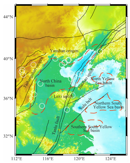
环渤海地区是我国大陆东部强震多发区,也是我国重要的新生代油气田产区.由于受太平洋板块的西向俯冲(Fukao et al.,1992; Zhao,2004; Lei and Zhao,2005,2006; Huang and Zhao,2006; Li et al.,2008; Lei,2012)和印度板块的北向碰撞挤压作用(Molnar and Tapponnier,1975; England and Houseman,1986; Tapponnier et al.,1986; Yin and Harrison,2000; Liu et al.,2004; Huang and Zhao,2006; Li et al.,2008; Lei et al.,2014),区域构造较为复杂,发育有多组北东、北北东向断裂,包含有华北盆地、太行山造山带、燕山造山带、鲁西隆起、苏鲁褶皱带和一些海域盆地,并伴随有多次7级以上历史强震发生(图 1).该地区位于华北克拉通中东部,是岩石圈发生明显的减薄和破坏的区域(Chen et al.,2008,2009),且不同学者对华北克拉通的破坏机制有着不同的见解(如Gao et al.,2004; Lei,2012; Menzies et al.,1993; Xu,2001; 朱日祥等,2012).
|
图 1 环渤海地区主要构造图 细实线为主要活动断裂. North China basin:华北盆地,Taihangshan orogen:太行山造山带,Yanshan orogen:燕山造山带,Luxi uplift:鲁西隆起,Jiaoliao uplift:胶辽隆起,Sulu belt:苏鲁褶皱带,North Yellow Sea basin:北黄海盆地,Northern South Yellow Sea basin:南黄海北部盆地,Southern South Yellow Sea basin:南黄海南部盆地,Tanlu fault:郯庐断裂带.红色虚线为块体 边界,白色圆圈为历史7级以上地震. Fig. 1 Sketch map of tectonics in the Bohai Sea and surrounding areas The thin and solid lines mark major active faults, whereas red and dashed lines represent block boundaries. The circles denote epicenters of earthquakes with magnitudes greater than 7.0. |
为深入理解华北克拉通破坏机制,高分辨率Pn波成像结果具有重要意义.尽管前人曾对该研究区开展过Pn波成像研究,获得了一些有意义的研究成果(胥颐等,2008; 李志伟等,2011).然而,由于其所用资料收集于观测报告,因而其模型空间分辨率具有一定限度.本研究除了使用已有观测报告资料外,还从地震波形上读取大量未包含在观测报告中的Pn波到时资料,这对于提高模型空间分辨率具有重要科学意义,也已被前人利用Pn 波成像结果所证实(黎源和雷建设,2012; Lei et al.,2014; Zhou and Lei,2015). 本研究收集1980—2015年研究区内观测报告资料,并增加2008—2014年期间4级以上地震被所在省或直辖市以外地震台站所记录到的Pn波到时资料,反演环渤海地区的Pn波速度结构及各向异性,获得研究区上地幔顶部高分辨率速度与各向异性模型,对于认识和理解研究区克拉通破坏机制和地壳强震发生机理具有重要意义.
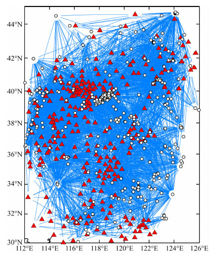
2 数据和方法本文采用的Pn波数据主要有3个来源:(1)1980—2004年期间的2795条Pn波到时来自胥颐等(2008)工作;(2)2005—2015年期间的6353条Pn波到时资料直接取自中国地震台网观测报告;(3)由“国家数字测震台网数据备份中心”提供的2008—2014年4级以上地震波形资料(郑秀芬等,2009),通过手工提取到前两个资料集中未包含的Pn波到时资料3068条.为保证数据的可靠,挑选的 Pn波到时资料采用以下标准:(1)震中距位于1.2°~10° 之间;(2)震源深度小于35 km;(3)每个地震被5个以上地震台站所记录;(4)每个台站记录到5个以上Pn波到时记录;(5)走时残差在±4 s之间.以上述这些标准作为条件,我们最终获得569个地震事件被265个地震台站记录到的10056个Pn到时数据.从图 2可以看出,Pn波地震射线分布除边缘地区相对稀疏外,研究区整体上较为密集.
|
图 2 环渤海地区Pn波射线(蓝线)分布图 红色三角为台站位置,白色圆圈为地震位置. Fig. 2 Ray paths (blue lines) in the Bohai Sea and surrounding areas Red triangles are seismic stations, whereas white circles are earthquake epicenters. |
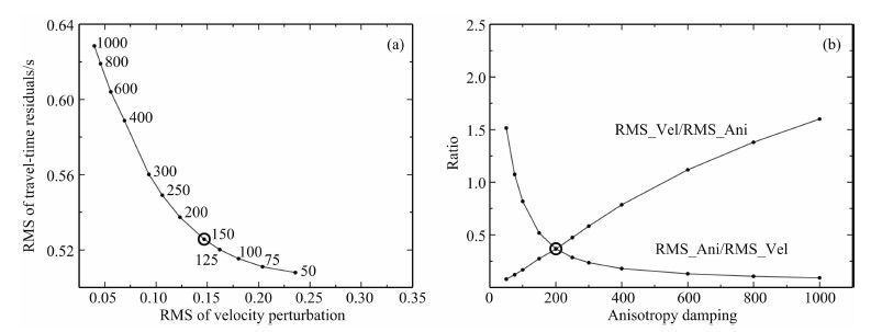
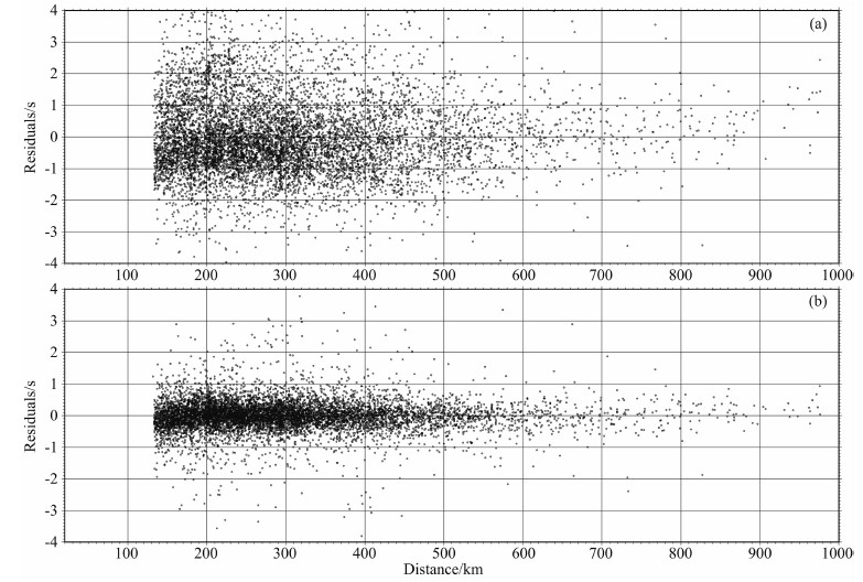
本文采用Hearn(1996)的方法反演Pn波速度结构及各向异性参数.将穿过上地幔顶部的Pn波震相的射线路径分为震源路径、接收路径和地幔路径.水平方向沿纬度和经度将上地幔顶部划分为若干等间距速度网格,Pn波的走时残差可表示为地震延迟项、台站延迟项、慢度变化和各向异性参数的方程组,选择反演网格的大小为0.2°×0.2°,上地幔顶部的Pn波平均速度为7.9 km·s-1,地壳内P 波平均速度为6.2 km·s-1,地壳平均厚度为35 km,采用阻尼最小二乘迭代算法进行求解.由于研究中使用了分别对速度和各向异性的阻尼因子,其中速度阻尼因子通过对速度变量的阻尼过程控制速度图像的平滑度和反演结果的误差,各向异性阻尼因子通过对各向异性变量的阻尼过程控制各向异性的平滑度.这两个阻尼因子均控制着低误差和高分辨率之间的折中(Tradeoff).同时,两个阻尼因子相互间的比值控制着速度变量的大小和各向异性变量的大小.我们采用与Hearn(1996)类似的方法选取最合理的一对阻尼因子.首先将不同阻尼因子反演计算获得的速度均方根和走时残差均方根绘制成L曲线(图 3a),选取该曲线的曲率最大的阻尼值作为最佳速度阻尼因子(Boschi et al.,2006).在确定各向异性阻尼因子时则通过引入模型计算速度与各向异性的相对折中来进行确定.各向异性对速度的折中定义为反演获得的速度扰动均方根与各向异性均方根的比值.固定已选取的速度阻尼因子,使用不同大小的各向异性阻尼因子进行反演,当速度对各向异性的折中与各向异性对速度的折中相等时所获得的各向异性阻尼值为最佳各向异性阻尼因子(图 3b).最终我们确定速度阻尼因子为150,各向异性阻尼因子为200.反演后的走时残差的标准差由反演前的1.33 s降低到了0.53 s,从图 4可以看出,反演后的残差明显地收敛.
|
图 3 速度阻尼因子(a)与各向异性阻尼因子(b)的选取 RMS_Vel/RMS_Ani 是速度扰动均方根与各向异性变化均方根之比,RMS_Ani /RMS_Vel 是各向异性变化均方根与速度扰动均方根之比. Fig. 3 Damping parameters chosen for velocity (a) and anisotropy (b) inversions RMS_Vel/RMS_Ani is the ratio of RMS of velocity perturbations to RMS of anisotropy variations, RMS_Ani/RMS_Vel is the ratio of RMS of anisotropy variations to RMS of velocity perturbations. |
|
图 4 资料走时残差分布 (a) 反演前; (b) 反演后. Fig. 4 Distribution of travel-time residuals (a) Before inversion; (b) After inversion. |
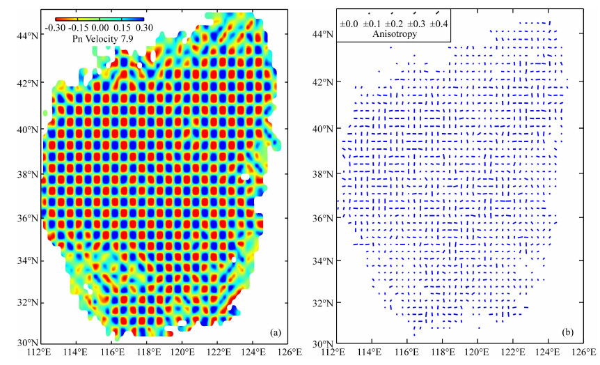
为了测试结果的可靠程度,本文利用Checkerboard方法对现有数据的分辨能力进行测试,初始模型Pn波平均速度为7.9 km·s-1,速度扰动和各向异性异常的幅度分别为0.3 km·s-1和0.4 km·s-1,采用与实际资料相同的反演方法重建不同尺度的检测板模型.通过大量的实验,从速度异常的恢复情况可以看出,除边缘地区射线覆盖较少外,大部分的速度异常都能得到很好的恢复.总的来说,在射线分布较为密集的区域图像恢复情况较好,速度异常的分辨率能达到0.5°×0.5°(图 5a),各向异性分辨率能达到1°×1°(图 5b).以下,主要讨论研究区内这些尺度的速度与各向异性的异常特征及构造意义.
|
图 5 Pn波速度0.5°×0.5°(a)和各向异性1°×1°(b)尺度异常的分辨率试验 (a)中红色代表低速异常,蓝色代表高速异常. (b)中蓝色线代表Pn波各向异性结果,其中长度代表各向异性强弱,走向代表各向异性快波方向. 速度与各向异性图例位于各自左上角. Fig. 5 Resolution tests for Pn velocity anomalies using cell sizes of 0.5°×0.5° (a) and anisotropy using cell sizes of 1°×1° (b) models In (a) red and blue colors denote low-V and high-V anomalies, whereas in (b) blue lines denote Pn anisotropy, the length and strike of which are the strength and fast direction of anisotropy. The scales are shown on their individual upper-left corner. |
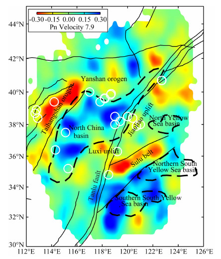
图 6为环渤海地区的Pn波速度反演结果,可以看出,研究区内上地幔顶部存在明显的横向非均匀性,与该区域的地质构造密切相关.相对于研究区模型Pn平均速度7.9 km·s-1,华北盆地表现为明显的高波速异常,且异常形态的分布与华北盆地构造块体的形态比较吻合.由于结果的分辨率较高,相比前人层析成像的上地幔顶部结果(汪素云等,2003;李志伟等,2006;Lei et al.,2008; Huang and Zhao,2004; 于湘伟等,2010; Li et al.,2011),可以更好地展现华北盆地的形态.太行山造山带地区表现为低波速异常,且低波速异常沿着山脉地区呈明显的条带状分布,与山脉的走向基本一致.燕山造山带地区表现为相对弱的低波速异常,鲁西隆起和胶辽隆起一带表现为低波速异常,苏鲁褶皱带表现为近NE向的低波速异常条带,与断裂带的走向相一致,且断裂两侧的速度高低波速异常比较明显,表明断裂带两侧具有不同的构造特征.以往研究表明,郯庐断裂带的构造活动具有明显的分段性,并且东西两侧存在明显差异,是一条深度穿越Moho面的断裂带,而其壳内低速层可能与软流圈物质上涌有关(叶高峰等,2009; 徐义刚等,2009; 漆家福等,2010; 黄耘等,2011; Lei,2012).本文结果表明,郯庐断裂带东西两侧波速结构存在明显差别,渤海带以西地区成像为明显高波速异常,而以东地区则为相对弱的低波速异常;在郯庐断裂带南端,以西地区为弱低波速异常,而以东地区为明显高波 速异常,说明郯庐断裂带为明显岩石圈尺度的断裂带.
|
图 6 环渤海地区Pn波速度结构与地震分布图像 红色和蓝色分别代表低波速和高波速异常,色标位于图左上角.其他标示与图1中的相同. Fig. 6 Pn-wave velocity and earthquakes (white circles) in the Bohai Sea and surrounding areas Red and blue colors denote low and high velocity anomalies, respectively, the scale of which is shown at the top-left corner. The other labeling is the same as that in Fig.1. |
图 6中白色圆圈代表该区域历史上发生的7级以上的壳内强震,从图中可以看出,壳内强震主要发生于低波速区边缘上或高低波速的过渡区,说明华北地区的壳内强震的发生可能受到来自上地幔深部动力环境的影响.中国东部最大的1668年山东郯城81/2级地震的发生位置位于郯庐断裂带和苏鲁褶皱带的交界处,Pn波高低波速变化明显.Pn波速度低意味着莫霍面温度较高(汪素云等,2003),可能存在热物质的上涌,而高低波速异常过渡带意味着相应区域介质的温度、岩性存在着明显差异,更容易诱发地震.类似的研究结果,在青藏高原东缘和天山地区的成像结果中得到证实(黎源和雷建设,2012; Lei et al.,2014; Zhou and Lei,2015).
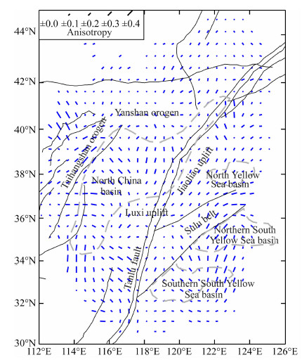
3.2 Pn波各向异性上地幔的各向异性可由地幔物质形变引起的地幔中橄榄岩晶轴的定向排列来解释,反映了最近一次构造运动遗留的变形痕迹.总体来说,在简单剪切形变条件下,橄榄岩的快波速方向趋向于与最大剪切应力方向平行,如岩石圈中的板块边界和穿透地壳的剪切带,各向异性快波速方向与剪切带平行;在纯剪切形变条件下,橄榄岩快波速方向将平行于岩石最大拉伸方向,如在岩石圈中没有断裂活动的地区,各向异性快波速方向垂直于最大压应力方向(Savage et al.,1993; Silver,1996;Hearn,1996,1999).造成地幔物质形变最直接的原因是板块运动,因此获取可靠的上地幔各向异性结果对于了解研究区板块运动过程具有重要意义.图 7为环渤海地区Pn波各向异性的分布图像.可以看出,太行山造山带西北部地区Pn波各向异性快波速方向为近NW向,与太行山山脉近乎垂直,与SKS的结果一致(常利军等,2011),可能暗示该地区下方地幔岩石圈存在耦合现象,上地幔物质受NW方向拉张作用发生了形变,在太行山山脉地区受到阻挡,属于纯剪切变形区.太行山造山带地区内的Pn波各向异性快波速方向为近NNE向,基本平行于断裂,与区域构造的伸展方向趋于一致,与常利军等(2009)的SKS结果差别较大,表明在地壳形变剧烈的地区,地幔岩石圈在一定深度范围内可能存在局部解耦现象.华北盆地内部南北区域各向异性差别较大,南部地区Pn波各向异性快波速方向为近EW向,而北部地区Pn波各向异性快波速方向为近NW向,SKS的结果也表现出类似的特征(常利军等,2009,2012).接收函数的结果显示,华北盆地的北部特别是渤海海域地区岩石圈较薄,而华北盆地南部岩石圈厚度相对较厚(Chen et al.,2008; Chen,2010).同时,体波成像结果表明,华北盆地南部上地幔为低波速异常,北部为高波速异常(李志伟等,2006),可能反映了华北盆地南部和北部地区岩石层的厚度和热状态的不均匀性.郯庐断裂带东西两侧的Pn波各向异性快波速方向存在明显的不同,西侧的优势方向近NW向,与绝对板块的运动方向一致,而东侧的优势方向近NNE向,可能是受到郯庐断裂带大规模剪切运动的影响,属于简单剪切变形区.苏鲁褶皱带地区Pn波各向异性快波速方向近NE向,一定程度上反映了苏鲁褶皱带的挤压变形特征.
|
图 7 环渤海地区Pn波各向异性 蓝色线代表Pn波各向异性结果,其中长度代表各向异性强弱,走向代表各向异性快波方向.其他标示与图1相同. Fig. 7 Pn anisotropy in the Bohai Sea and surrounding areas Blue lines denote Pn anisotropy, length and strike of which denote the anisotropic strength and fast direction of anisotropy. The other labeling is the same as that in Fig.1. |
由于受太平洋板块的西向俯冲,华北克拉通中东部遭到严重的破坏和减薄.层析成像结果表明(Huang and Zhao,2006; Lei,2012; Tian and Zhao,2011,2013),华北克拉通中部造山带上地幔存在明显的低波速异常,得到本文上地幔顶部研究结果(图 6)的支持,可能暗示着下方有地幔柱的存在.而华北克拉通东部地幔转换带内存在明显的高波速异常,可能是滞留的太平洋俯冲板片.本研究结果显示的华北盆地整体呈高波速异常,而鲁西地区和苏鲁褶皱带为明显低波速异常(图 6),表明华北盆地岩石圈的破坏与减薄对上地幔顶部的速度结构影响较小,而对鲁西地区和苏鲁褶皱带影响较大.接收函数结果也证实了鲁西隆起、渤海海域及郯庐断裂带附 近是岩石圈减薄最强烈的地区,厚度约60~80 km,而华北盆地南部岩石圈厚度有所增加,达到110 km 左右(Chen et al.,2008,2009).太行山造山带和苏鲁褶皱带地区内的Pn波各向异性快波速方向与断裂带的走向基本一致,说明浅部地壳剧烈变形受到上地幔结构与动力环境的影响.这些结果对于理解华北克拉通破坏机制具有重要科学意义.体波成像结果显示出,环渤海地区地壳上地幔的速度结构具有明显的横向不均匀性,壳内强震发生区域的下地壳至上地幔存在大范围的低波速异常体(Lei et al.,2008; Huang and Zhao,2004; 李志伟等,2006; Lei,2012).本文结果显示,壳内强震发生于Pn波低波速区和高低波速异常的过渡带上,表明壳内强震的发生可能与上地幔顶部介质结构的横向不均匀性存在一定联系.
5 结论本研究利用环渤海地区的Pn波到时资料反演得到该地区上地幔顶部高分辨率的Pn波速度及各向异性结构.研究表明:环渤海地区Pn波速度结构与区域地质构造形态比较吻合,隆起地区主要表现为Pn波低波速异常,凹陷地区主要表现为Pn波高波速异常.壳内强震主要发生于Pn波低波速区以及高低波速异常的过渡带上,可能与热物质上涌、莫霍面温度升高及上地幔顶部介质的不均匀性有关.Pn波各向异性快波方向与区域构造特征存在一定的联系,太行山造山带和苏鲁褶皱带地区Pn波各向异性快波速方向基本平行于断裂,与区域构造的伸展方向趋于一致,可能受上地幔顶部结构和动力过程的影响.华北盆地的南部和北部地区各向异性有一定差异,可能与岩石层厚度和热状态不均匀性有关.
致谢感谢 Thomas M. Hearn提供的Pn波成像程序.中国地震局地球物理研究所国家数字测震台网数据备份中心为本研究提供地震波形数据,两位审稿专家对本文提出的诸多宝贵建议,使文章增色不菲,在此一并表示感谢.
| Boschi L, Becker T W, Soldati G, et al. 2006. On the relevance of Born theory in global seismic tomography. Geophys. Res. Lett. , 33(6): L06302. | |
| Chang L J, Wang C Y, Ding Z F. 2009. Seismic anisotropy of upper mantle in eastern China. Sci. China Ser. D-Earth Sci. , 52(6): 774–783. | |
| Chang L J, Wang C Y, Ding Z F. 2012. Upper mantle anisotropy beneath North China. Chinese Journal of Geophysics , 55(3): 886–896. doi: 10.6038/j.issn.0001-5733.2012.03.018. | |
| Chen L, Wang T, Zhao L, et al. 2008. Distinct lateral variation of lithospheric thickness in the Northeastern North China Craton. Earth and Planetary Science Letters , 267(1-2): 56–68. | |
| Chen L, Cheng C, Wei Z G. 2009. Seismic evidence for significant lateral variations in lithospheric thickness beneath the central and western North China Craton. Earth and Planetary Science Letters , 286(1-2): 171–183. | |
| Chen L. 2010. Concordant structural variations from the surface to the base of the upper mantle in the North China Craton and its tectonic implications. Lithos , 120(1-2): 96–115. | |
| England P, Houseman G. 1986. Finite strain calculations of continental deformation: 2. Comparison with the India-Asia collision zone. Journal of Geophysical Research , 91(B3): 3664–3676. | |
| Fukao Y, Obayashi M, Inoue H, et al. 1992. Subducting slabs stagnant in the mantle transition zone. Journal of Geophysical Research , 97(B4): 4809–4822. | |
| Gao S, Rudnick R L, Yuan H L, et al. 2004. Recycling lower continental crust in the North China craton. Nature , 432(7019): 892–897. | |
| Hearn T M. 1996. Anisotropic Pn tomography in the western United States. Journal of Geophysical Research , 101(B4): 8403–8414. doi: 10.1029/96JB00114. | |
| Hearn T M. 1999. Uppermost mantle velocities and anisotropy beneath Europe. Journal of Geophysical Research , 104(B7): 15123–15139. | |
| Huang J L, Zhao D P. 2004. Crustal heterogeneity and seismotectonics of the region around Beijing, China. Tectonophysics , 385(1-4): 159–180. | |
| Huang J L, Zhao D P. 2006. High-resolution mantle tomography of China and surrounding regions. Journal of Geophysical Research , 111(B9): B09305. doi: 10.1029/2005JB004066. | |
| Huang Y, Li Q H, Zhang Y S, et al. 2011. Crustal velocity structure beneath the Shandong-Jiangsu-Anhui segment of the Tancheng-Lujiang Fault Zone and adjacent areas. Chinese Journal of Geophysics , 54(10): 2549–2559. doi: 10.3969/j.issn.0001-5733.2011.10.012. | |
| Lei J S, Zhao D P. 2005. P-wave tomography and origin of the Changbai intraplate volcano in Northeast Asia. Tectonophysics , 397(3-4): 281–295. | |
| Lei J S, Zhao D P. 2006. Global P-wave tomography: on the effect of various mantle and core phases. Physics of the Earth and Planetary Interiors , 154(1): 44–69. | |
| Lei J S, Xie F R, Lan C X, et al. 2008. Seismic images under the Beijing region inferred from P and PmP data. Physics of the Earth and Planetary Interiors , 168(3-4): 134–146. | |
| Lei J S. 2012. Upper-mantle tomography and dynamics beneath the North China Craton. Journal of Geophysical Research , 117(B06): B06313. | |
| Lei J S, Li Y, Xie F R, et al. 2014. Pn anisotropic tomography and dynamics under eastern Tibetan plateau. Journal of Geophysical Research , 119(3): 2174–2198. | |
| Li C, van der Hilst R D, Meltzer A S, et al. 2008. Subduction of the Indian lithosphere beneath the Tibetan Plateau and Burma. Earth and Planetary Science Letters , 274(1-2): 157–168. | |
| Li Y, Lei J S. 2012. Velocity and anisotropy structure of the uppermost mantle under the eastern Tibetan plateau inferred from Pn tomography. Chinese Journal of Geophysics , 55(11): 3615–3624. doi: 10.6038/j.issn.0001-5733.2012.11.010. | |
| Li Z W, Xu Y, Hao T Y, et al. 2006. Seismic tomography and velocity structure in the crust and upper mantle around Bohai Sea area. Chinese Journal of Geophysics (in Chinese) , 49(3): 797–804. | |
| Li Z W, Hao T Y, Xu Y. 2011. Uppermost mantle structure of the North China Craton: Constraints from interstation Pn travel time difference tomography. Chinese Sci. Bull. , 56(16): 1691–1699. | |
| Liu M, Cui X J, Liu F T. 2004. Cenozoic rifting and volcanism in eastern China: A mantle dynamic link to the Indo-Asian collision?. Tectonophysics , 393(1-4): 29–42. | |
| Menzies M A, Fan W M, Zhang M. 1993. Palaeozoic and Cenozoic lithoprobes and the loss of > 120 km of Archaean lithosphere, Sino-Korean craton, China. Geol. Soc. Spec. Pub. , 76(1): 71–78. | |
| Molnar P, Tapponnier P. 1975. Cenozoic tectonics of Asia: Effects of a continental collision. Science , 189(4201): 419–426. | |
| Qi J F, Zhou X H, Wang Q S. 2010. Structural model and Cenozoic kinematics of Tan-Lu deep fracture zone in Bohai Sea area. Geology in China (in Chinese) , 37(5): 1231–1242. | |
| Savage M K, Silver P G. 1993. Mantle deformation and tectonics: Constraints from seismic anisotropy in the western United States. Physics of the Earth and Planetary Interiors , 78(3-4): 207–227. | |
| Silver P G. 1996. Seismic anisotropy beneath the continents: Probing the depths of geology. Annual Review of Earth and Planetary Sciences , 24: 385–432. | |
| Tapponnier P, Peltzer G, Armijo R. 1986. On the mechanics of the collision between India and Asia.//Coward M, Ries A eds. Collision Tectonics. Geol. Soc. London Spec. Publ., 19(1): 113-157. | |
| Tian Y, Zhao D P. 2011. Destruction mechanism of the North China Craton: Insight from P and S wave mantle tomography. Journal of Asian Earth Sciences , 42(6): 1132–1145. | |
| Tian Y, Zhao D. 2013. Reactivation and mantle dynamics of North China Craton: insight from P-wave anisotropy tomography. Geophysical Journal International , 195(3): 1796–1810. | |
| Wang S Y, Xu Z H, Pei S P. 2003. Pn wave velocity structure of at the uppermost mantle of the northern China and tectonic implication. Science in China (Series D) (in Chinese) , 33(Suppl.): 91–98. | |
| Xu Y G. 2001. Thermo-tectonic destruction of the Archaean lithospheric keel beneath the Sino-Korean Craton in China: Evidence, timing and mechanism. Phys. Chem. Earth , 26(9-10): 747–757. | |
| Xu Y, Li Z W, Liu J S, et al. 2008. Pn wave velocity and anisotropy in the Yellow Sea and adjacent region. Chinese Journal of Geophysics (in Chinese) , 51(5): 1444–1450. | |
| Ye G F, Wei W B, Jin S, et al. 2009. Study of the electrical structure and its geological meanings of the middle part of Tancheng-Lujiang fault zone. Chinese Journal of Geophysics , 52(11): 2818–2825. doi: 10.3969/j.issn.0001-5733.2009.11.016. | |
| Yin A, Harrison T M. 2000. Geologic evolution of the Himalayan-Tibetan orogen. Annual Review of Earth and Planetary Sciences , 28: 211–280. | |
| Yu X W, Chen Y T, Zhang H. 2010. Three-dimensional crustal P-wave velocity structure and seismicity analysis in Beijing-Tianjin-Tangshan Region. Chinese Journal of Geophysics , 53(8): 1817–1828. doi: 10.3969/j.issn.0001-5733.2010.08.007. | |
| Zhao D P. 2004. Global tomographic images of mantle plumes and subducting slabs: insight into deep Earth dynamics. Physics of the Earth and Planetary Interiors , 146(1-2): 3–34. | |
| Zheng X F, Ouyang B, Zhang D N, et al. 2009. Technical system construction of Data Backup Centre for China Seismograph Network and the data support to researches on the Wenchuan earthquake. Chinese Journal of Geophysics , 52(5): 1412–1417. doi: 10.3969/j.issn.0001-5733.2009.05.031. | |
| Zhou Z G, Lei J S. 2015. Pn anisotropic tomography under the entire Tienshan orogenic belt. Journal of Asian Earth Sciences , 111: 568–579. | |
| Zhu R X, Xu Y G, Zhu G, et al. 2012. Destruction of the North China Craton. Sci. China Earth Sci. (in Chinese) , 42(8): 1135–1159. | |
| 常利军, 王椿镛, 丁志峰. 2009. 中国东部上地幔各向异性研究. 中国科学: 地球科学 , 39(9): 1169–1178. | |
| 常利军, 王椿镛, 丁志峰. 2011. 鄂尔多斯块体及周缘上地幔各向异性研究. 中国科学: 地球科学 , 41(5): 686–699. | |
| 常利军, 王椿镛, 丁志峰. 2012. 华北上地幔各向异性研究. 地球物理学报 , 55(3): 886–896. | |
| 黄耘, 李清河, 张元生, 等. 2011. 郯庐断裂带鲁苏皖段及邻区地壳速度结构. 地球物理学报 , 54(10): 2549–2559. | |
| 黎源, 雷建设. 2012. 青藏高原东缘上地幔顶部Pn波速度结构及各向异性研究. 地球物理学报 , 55(11): 3615–3624. | |
| 漆家福, 周心怀, 王谦身. 2010. 渤海海域中郯庐深断裂带的结构模型及新生代运动学. 中国地质 , 37(5): 1231–1242. | |
| 李志伟, 胥颐, 郝天珧, 等. 2006. 环渤海地区的地震层析成像与地壳上地幔结构. 地球物理学报 , 49(3): 797–804. | |
| 李志伟, 郝天珧, 徐亚. 2011. 华北克拉通上地幔顶部构造特征: 来自台站间Pn波到时差成像的约束. 科学通报 , 56(12): 962–970. | |
| 汪素云, 许忠淮, 裴顺平. 2003. 华北地区上地幔顶部Pn波速度结构及其构造含义. 中国科学D辑: 地球科学 , 33(增刊): 91–98. | |
| 叶高峰, 魏文博, 金胜, 等. 2009. 郯庐断裂带中段电性结构及其地学意义研究. 地球物理学报 , 52(11): 2818–2825. | |
| 胥颐, 李志伟, 刘劲松, 等. 2008. 黄海及其邻近地区的Pn波速度与各向异性. 地球物理学报 , 51(5): 1444–1450. | |
| 徐义刚, 李洪颜, 庞崇进, 等. 2009. 论华北克拉通破坏的时限. 科学通报 , 54(14): 1974–1989. | |
| 于湘伟, 陈运泰, 张怀. 2010. 京津唐地区地壳三维P波速度结构与地震活动性分析. 地球物理学报 , 53(8): 1817–1828. | |
| 郑秀芬, 欧阳飚, 张东宁, 等. 2009. "国家数字测震台网数据备份中心"技术系统建设及其对汶川大地震研究的数据支撑. 地球物理学报 , 52(5): 1412–1417. | |
| 朱日祥, 徐义刚, 朱光. 2012. 华北克拉通破坏. 中国科学: 地球科学 , 42(8): 1135–1159. | |
 2016, Vol. 59


