 2016, Vol. 59


2. 四川省地震局测绘工程院, 四川雅安 625000;
3. Institute of Applied Mathematics, Far Eastern Branch of Russian Academy of Sciences, Vladivostok 690091, Russia;
4. Far Eastern Federal University, Vladivostok 690068, Russia
2. Institute of Engineering Survey and Mapping, Earthquake Administration of Sichuan Province, Sichuan Ya'an 625000, China;
3. Institute of Applied Mathematics, Far Eastern Branch of Russian Academy of Sciences, Vladivostok 690091, Russia;
4. Far Eastern Federal University, Vladivostok 690068, Russia
2010年4月14日7时49分(当地时间)青海省玉树藏族自治州发生MS7.1地震,震中位于(33.11°N,96.59°E),震源深度14 km (中国地震台网统一正式地震目录,http://10.5.202.22).玉树地震发生在甘孜-玉树断裂带上,该断裂带是一条沿北西-南东方向延伸、以左旋走滑为主的断裂带,是巴颜喀拉地块和羌塘地块的构造边界,总长约500 km (闻学泽等,2003).此次地震在地表引起一条长约50~65 km的破裂带,以走滑为主,具有50 m的宽度(Chen et al., 2010; Li et al., 2012).发震断层面走向119°,倾角83°,滑动角-2°,为高角度左旋走滑破裂(张勇等,2010).自主震发生时刻至12月31日共发生余震2千多次,最大震级达到6.4级(王未来等,2012).
利用GPS等大地测量技术可以观测大地震之后的地表形变,获取震后形变特征(任金卫等,2005;丁开华等,2013),进而分析震后形变机制、研究断层摩擦性质和岩石圈黏弹性结构(Wen et al., 2012;Gonzalez-ortega et al., 2014).GPS观测的震后形变可能包括有多种因素的贡献,如区域构造运动、余震活动、孔隙弹性反弹、余滑、岩石圈应力松弛等(Wang et al., 2010).前人研究结果显示震后余滑和岩石圈应力松弛是震后形变的主要因素(Marone et al. 1991; Shen et al., 1992; Pollitz et al., 1997),在震后早期阶段震后余滑占主导地位,在震后的中期至后期阶段,岩石圈应力松弛占主导地位(Wang et al., 2009).
玉树地震发生后,中国地震局地震预测研究所联合四川省地震局测绘工程院立即成立应急观测小组赴震区开展GPS建站和观测工作,在震后7~10天内新建9个GPS测站,利用6个已有的“中国地壳运动观测网络”测站,组成一条跨玉树发震断裂的观测剖面(图 1),剖面长度360 km左右,其中包括1个连续观测站(QHYS)、3个半连续观测站(J392,YS01, YS04)和11个流动观测站,对该剖面进行了240多天的观测.本文通过对观测数据进行高精度解析得到相对ITRF2005(Altamimi et al., 2007)的测站坐标时间序列,利用构造块体欧拉矢量模型和孕震层下方脆韧转换带蠕动模型去除构造活动引起的背景运动.基于双差定位余震目录,计算余震引起的形变,并对其进行改正.采用对数模型对位移时间序列进行拟合,给出了震后地表形变时空衰减特征.采用最速下降法反演了震后余滑分布,并对震后形变机制进行了分析和讨论.

|
图 1 (a)研究区域位置; (b)青海玉树区域地震构造 (a)图中黑色方框代表研究区域,黑色实线为青藏高原活动地块边界.蓝色五角星为玉树地震震中位置; (b)图中“沙滩球”表示玉树地震震源机制解,红色圆为余震分布,黑色实线表示断层. Fig. 1 (a) Location of study area; (b) Seismo-tectonic of Yushu area, Qinghai Province |
在2010年4月20日完成GPS观测仪器的架设后,青海玉树站(QHYS)作为唯一的连续站一直保持连续观测.3个半连续站和和11个流动观测站自2010年4月20日至11月25日共观测5期(表 1),第一期包括建站和观测,并持续11天,其后4期观测每期都为6天.基于震后地表形变衰减快的特点确定相邻2期观测间隔时间,越到后期,间隔时间越长.5期观测均采用Trimble 5700、Trimble NetRS GPS接收机和TRM29659.00扼径圈天线,在各期观测中保证在同一站点采用同一台接收机和天线,以减少因接收机和天线不同可能导致的系统误差.
|
|
表 1 玉树地震震后地壳形变GPS观测方案 Table 1 Postseismic GPS observation scheme for the Yushu earthquake |
采用GAMIT/GLOBK软件(Herring et al., 2008)进行GPS数据处理,GPS数据包括本文15个剖面站、“网络工程”25个基准站以及中国大陆周边13个IGS连续站的数据.对卫星轨道进行一定的松弛,涉及的地球重力场、固体潮和极潮模型遵循IERS2003规范.采用FES2004模型改正海潮引起的测站形变.选择卫星截止高度角大于10°的数据用于数据编辑和参数估计,观测数据的定权采用卫星截止高度角的函数,采用LC组合观测量以消除电离层一阶项影响.对流层天顶延迟改正采用GPT模型,对每个测站每1个小时估计1个天顶延迟参数,映射函数采用GMF模型,对每个测站的EW向和NS向各附加1个大气水平梯度参数.把解算的单日松弛解和全球IGS核心站单日松弛解合并,得到包含剖面站、“网络工程”基准站和IGS核心站的单日松弛解.选择较均匀地分布于全球、在ITRF2005全球参考框架(Altamimi et al., 2007)中水平速度分量中误差较小的IGS站作为框架站,并将IGS核心站的坐标和速度约束于ITRF2005框架,解算GPS剖面站在ITRF2005中的坐标,进而通过坐标差分得到各测站相对于发震时刻的位移时间序列.
3 构造运动引起的地壳背景形变及其改正经过上述GPS数据处理得到的相对于ITRF2005的位移时间序列包含构造的背景运动和震后形变,为了提取出震后形变,需从中扣除构造运动引起的位移分量.构造运动引起的背景运动可由地震前多年的GPS观测得到,由于本文的GPS测站有9个是震后7~10天内建立的新站,6个先存的“网络工程”区域站在震前只有一期观测,因此,这15个站点都缺乏背景速度.
本文收集了青藏高原地区“中国地壳运动观测网络”自1999年至2010年玉树MS7.1地震前所有GPS原始观测数据,并进行高精度数据处理,获取了相对于ITRF2005(Altamimi et al., 2007)的速度场.GPS站的背景运动速度包括2部分:(1) 弹性块体的长期运动速度;(2) 孕震层下方脆韧转换带蠕动引起的形变.前者可由欧拉矢量模型计算(Argus et al., 2010; Altamimi et al., 2012),后者可由位错模型计算(Savage & Burford,1973).考虑到甘孜-玉树断层具有较强的活动性(闻学泽等,2003),跨该断裂的研究区不可以作为一个整体计算其欧拉矢量,本文分别计算断层两侧巴颜喀拉块体和羌塘块体相对ITRF2005的欧拉矢量,然后用之分别计算发震断层东北侧和西南侧GPS站的速度,计算的EW速度在41.7~47.9 mm·a-1之间,NS速度在-8.98~-2.11 mm·a-1之间.采用线性关系计算每一个观测时间的位移,并从各GPS测站相对于ITRF2005的位移时间序列中扣除该分量.
对于孕震层下方脆韧转换带蠕动引起的地表形变,可以采用弹性半空间的弹性模型(Savage & Burford, 1973),也可以采用水平分层的黏弹性位错模型(Wang et al., 2006)进行计算,本文采用后者进行计算.鉴于甘孜-玉树断裂带上地震震源深度分布主要位于5~20 km (王未来等,2012),因此假定地表至地下20 km为完全闭锁.为了避免断层端部效应的影响,假定在20 km以下存在一条长度为400 km,深度方向宽度为100 km的位错,走向为119°,上边界的中点位于玉树地震震源.采用Ryder等(2014)的岩石圈分层模型,参考玉树地震的震源机制(张勇等,2010),设位错的倾角为83°,滑动方式为左旋错动.参考Lin等(2011)研究结果,设脆韧转换带蠕动速率为8 mm·a-1.计算结果(表 2)显示,影响最大的站为YS07,其EW和NS速度分别为0.70~0.38 mm·a-1,总速度为0.80 mm·a-1.由此可知,孕震层下方脆韧转换带蠕动引起的地表形变较小,因此在后续的分析中不予考虑.
|
|
表 2 脆韧转换带蠕动引起的GPS站背景速度 Table 2 Background velocities due to creeping of brittle-ductile transition belt |
本文挑选14个4级以上的余震,计算其在地表引起的位移.假定这些余震的震源机制与主震的相同,余震破裂面的尺度及滑动量由尺度定理(Wells和Coppersmith, 1994)进行计算.采用Ryder等(2014)给出的岩石圈黏弹性分层模型,上层为弹性层,其厚度为15 km,下层为Maxwell黏弹性层,其黏滞度为6×10¹⁹Pa·s.利用矩形位错模型计算余震在地表15个GPS测站引起的位移(图 2),应用PSGRN/PCMP程序进行计算(Wang et al., 2006).

|
图 2 M≥4.0余震及其在GPS测站引起的地表形变 横轴坐标原点为主震发生时刻,折线中的阶变表示余震引起的同震地表位移. Fig. 2 M≥4 aftershocks and induced surface deformation at GPS sites Origin of horizontal axis is the occurrence time of mainshock. Steps in the broken lines indicate displacements due to the aftershocks. |
图 2表明主震后1.5 h发生的MS6.4余震和第46天发生的MS5.9余震影响较大,其余震级较小的余震引起的位移量很小.余震活动在一些测站引起明显的地表位移,余震导致YS05站EW位移达到约3 mm,NS位移达到约7 mm.由于余震对GPS观测的震后形变影响不可忽略,需要从GPS观测的位移时间序列中扣除其分量.需要说明的是,由于YS03、J390、J396、J397、J399测站NS位移值与其他测站接近,YS01的觇标曾遭受一定的破坏,为使图形清晰,余震在这些站引起的位移未在图 2中画出.
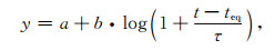
5 GPS观测的震后形变与函数拟合对经过构造形变、余震形变改正的位移时间序列进行函数拟合,以分析震后形变的连续变形过程.可以采用不同的函数模型,如指数衰减模型(Shen et al., 1994)、对数衰减模型(Savage and Svarc, 2009)和速率增强的摩擦律(Barbot et al., 2009)对震后形变进行拟合.本文采用如下对数模型拟合震后位移:
|
(1) |
其中,a为震后位移时间序列初始常数,b为震后位移衰减振幅,teq为地震发生的时间,τ为衰减时间.式中a、b和τ为待估参数.对τ全局进行搜索,把非线性方程转化为线性方程,采用奇异值分解法对法方程进行求逆,并且约束EW和NS分量具有相同的衰减时间.由于各站总体观测时间长度不尽相同,故选择其中7个总体观测时间较长,观测质量较好的QHYS、J396、YS08、J399、YS06、YS05和YS07测站,对其位移时间序列进行拟合,解算出的特征衰减时间为6.7±0.2天,然后将其代入公式(1),分别解算其参数a和b.对于余下的7个测站,固定其特征衰减时间,分别计算其常数a和振幅b,计算结果见表 3.
|
|
表 3 震后位移时间序列对数函数拟合结果 Table 3 Logarithmic fitting of postseismic displacement time series |
图 3和图 4分别给出了玉树断层北侧和南侧GPS测站震后变形时间序列及对数模型拟合结果.总体上显示出测站越靠近断层,其震后变形越大,随着测站远离断层,其变形幅度逐渐减少.由于测站相对稀少,无法测试变形是否相对断层破裂带具有对称性,但断层两侧测站的位移大致是相等的.表 4给出了震后250天各测站累计的震后位移,该表显示出距断层最近的QHYS站具有最大的形变,震后250天累积位移达到17.57 mm.其次是位于破裂带东北侧的YS04和J397站,二者都表现为西向运动为主,兼有有少量南向运动,位移幅度分别达到15.82 mm和14.50 mm.距离断层最远的测站J400和J390站分别位于断层的最北侧和最南侧,变形幅度分别为2.64 mm和2.48 mm,这两个测站距离断层破裂带的距离都超过175 km.位于断层以北的测站具有少量的南向运动,而位于断层以南的测站具有少量的北向运动.总体上显示出主震发生后玉树断层具有以左旋为主,兼有少量挤压的特征.

|
图 3 玉树断层北侧GPS测站震后位移对数模型拟合结果(实心圆圈为观测位移,蓝线为模型曲线) Fig. 3 Logarithmic fitting of postseismic displacementsfor GPS sites north of Yushu fault (Solid circles indicate observational displacements, and blue curves are modeled displacements) |

|
图 4 玉树断层南侧GPS测站震后位移对数模型拟合结果(实心圆圈为观测位移,蓝线为模型结果) Fig. 4 Logarithmic fitting of postseismic displacements for GPS sites south of Yushu fault (Solid circles indicate observational displacements, and blue curves are modeled displacements) |
|
|
表 4 由对数模型计算的震后250天累积位移 Table 4 Logarithmic model derived cumulative displacements during 250 days following the mainshock |
主震之后的前50天,各测站的形变显示出快速的衰减过程,之后衰减变慢,震后前50天的位移量与震后250天的位移量的比值都超过50%.就玉树连续站而言,震后50~100、100~150、150~200天、200~250天的位移量与震后250天内位移的比值分别为58.61%,17.33%,10.58%, 5.93%,显示出比较完整的衰减过程.
6 震后余滑反演前人基于InSAR、GPS、地震波形数据反演了玉树地震的同震破裂模型(Li et al., 2011; Tobita et al., 2011; Jiang et al., 2013; Meng et al., 2013; Qu et al., 2013, 李奇, 2015).本文参考李奇(2015)联合GPS和InSAR数据的反演结果,把断层面离散化为规则的子断层,每个子断层的尺度为2 km×2 km.仍采用分层的黏弹性岩石圈模型(Ryder et al., 2014).利用最速下降法(Cervelli et al., 2001)反演各子断层的滑移矢量.采用拉普拉斯算子平滑相邻的子断层位错量,该算子的平滑作用由平滑因子控制,平滑因子α的选择由模型粗糙度相对数据拟合残差的L曲线确定(Segall and Harris 1987;D′Agostino et al., 2012).
以本文第5节给出的对数模型计算震后位移,并依此为约束数据反演震后余滑,采用位移误差平方的倒数作为其权重,对于土层站点的位移数据,作进一步降权,使其权重降为基岩点的60%.通过改变数据自由度进行多次反演.首先约束断层滑动为左旋走滑,然后假定断层为走滑兼逆冲,反演结果显示出观测数据主要可以由左旋走滑分量进行解释,对倾滑分量的方向不进行约束,容许其沿着断层发生变化.对走滑和倾滑分量施加平滑约束,并采用L曲线方法确定数据的拟合质量和模型的粗糙度.在反演过程中调整平滑因子,得到L曲线如图 5所示.平滑因子α取为0.1,反演得到震后250天余滑的空间分布(图 6).由观测数据与模型位移的对比(图 7)可知,所有测站的观测数据与模型计算的位移具有较好的一致性,大部分位移的残差小于2.0 mm,数据和模型的相关性达到97.8%.

|
图 5 归一化数据拟合残差与模型粗糙度归一化值关系 模型粗糙度表示余滑在空间上的梯度,归一化残差表示拟合残差平均值的相对大小. Fig. 5 Relationship between normalized model roughness and normalized residuals Model roughness indicates the roughness of model slip; Normalized fitting residual indicates the average relative residuals. |

|
图 6 余滑与同震位错对比 红色实心圆圈为余震,黄色五角星为主震震源,黑色箭头为余滑矢量.(a)同震位错模型(李奇,2015);(b)主震后250天余滑分布. Fig. 6 Comparison of after slip and coseismic slip Red solid circles indicate aftershocks, yellow asterisk is focus of mainshock, and black arrows are afterslip vector. (a) Coseismic slip distribution; (b) After slip during 250 days after the mainshock. |

|
图 7 主震后250天地表累积位移和余滑模型计算的位移对比(“沙滩球”为主震的震源机制) Fig. 7 Cumulative displacements during 250 days following the mainshock and the displacement predicted by the afterslip model (The beachball indicates focal mechanism of the mainshock) |
余滑的空间分布显示出,在震后250天断层的余滑角2~10°,表明断层活动以为左旋滑动为主,断层南盘具有少量的抬升.与同震滑动分布模型对比可知,余滑与同震破裂在空间分布上具有一定的互补性,余滑主要位于同震破裂区的两侧,西北侧的余滑达到地表,最大滑动量为0.19 m.东南端的余滑区位于同震破裂区的下方,深度在10~20 km范围,最大余滑量达到0.23 m.屈春燕等(2013)基于ENVISAT/ASAR雷达数据给出了玉树震后的形变场,发现在结古镇西北方向主震的微观震中区域存在较大范围的形变,并认为是震后余滑引起的.本文反演得到的西北端的余滑区与其得到的地表形变存在一致性.
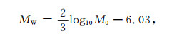
对断层面上余滑量进行积分,并乘以地壳剪切模量可以计算出震后余滑的距释放.对于破裂的地壳岩石,假定其剪切模量为10~33 GPa (Hamiel et al., 2006;Cochran et al., 2009).在震后250天内,震后余滑的矩释放为(1.5~5.1)×1018 Nm,余震释放的矩为2.2×10¹⁷ Nm,余滑矩释放与余震距释放的比值7.0~22.7,显示出玉树地震震后形变主要是非震形变引起的.利用矩震级计算公式(Kanamori, 1977):
|
(2) |
式(2)中,M0为余滑释放的距,MW为矩震级,可计算出玉树地震余滑相当于释放一次MW6.1~6.4地震的能量.
利用对数拟合模型计算震后50、100、150天和200天4个时间段的累计位移,并以此为约束反演震后余滑的时空演化(图 8),发现西北侧和东南侧2个余滑区在空间位置上保持不变,随着离逝时间增加,余滑的区域逐渐扩大.

|
图 8 余滑时空演化 红色箭头表示余滑矢量,五角星为主震的震源. (a)震后50天;(b)震后100天;(c)震后150天;(d)震后200天. Fig. 8 Spatiotemporal afterslip distribution Red arrows indicate afterslip vectors, and the asterisk is focus of mainshock. (a), (b), (c), (d) are afterslips in the periods of 50, 100, 150 and 250 days following the main shock, respectively. |
已有研究表明中强以上地震之后的早期阶段,地壳形变速率高于中期和后期阶段(Ozawa et al., 2012; Wang et al., 2012;Sun et al., 2014),形变速率的快速降低是震后早期形变的基本特征(Hu and Wang, 2012; Sun et al., 2014).由于岩石圈对同震应力变化的响应,地震后产生瞬态形变,其物理成因主要包括如下几种:震后余滑(Marone et al., 1991; Perfettini et al., 2004; Barbot et al., 2009),液体饱和的地壳孔隙弹性反弹(Peltzer et al., 1998, Jonsson et al., 2003; Fialko, 2004), 下地壳与上地幔中的黏弹性松弛,断层区体积变化(Massonnet et al., 1996; Jacobs et al., 2002; Fielding et al., 2009).GPS接收机记录的震后形变是多种因素的综合影响结果,目前利用震后形变数据完全分离各种因素的影响或评估其相对重要性仍然是十分困难的(Hu and Wang, 2012; Nykolaishen, 2015),尤其是仅具有震后早期阶段短期的形变时间序列(Wang et al., 2012).
7.1 孔隙弹性反弹引起的地表形变地壳孔隙弹性反弹是由震时孔隙压力改变造成孔隙流体渗流引起的,孔隙流体反弹时间尺度依赖于岩石的有效渗透率,通常持续数天到数年(Peltzer et al., 1998;Hu et al., 2014),其引起的地表形变难以由解析方法得到,其时间衰减是非线性的(Fialko, 2004).但可利用地壳的2个状态估计孔隙弹性反弹引起的地表形变,第一个状态代表地壳对地震的瞬时响应,称为未排空水(undrained)状态.第二个状态是孔隙流体压力引起的扰动达到平衡条件,短期的孔隙弹性流体流动已经完成,达到平衡状态.这与排干状态(drained)不同,排干状态表示由于缓慢的加载过程和较高的可渗透率,孔隙流体压力没有变化(Hu et al., 2014).利用同震破裂模型计算这两种状态下形变的差异可以近似为时间相依的孔隙弹性反弹总的影响,代表孔隙弹性反弹形变的最大估计.液体饱和的地壳孔隙弹性反弹引起的地表形变主要集中在发震断层带的端部(Peltzer et al., 1998; Jonsson et al., 2003).
利用地震前后泊松比的变化,采用均匀弹性半空间或分层黏弹性位错模型可模拟孔隙弹性反弹引起的累计震后形变(Segall, 2010).假定未排干流体的地壳泊松比υu=0.27,平衡状态的地壳泊松比υd=0.31 (Riceand Cleary 1976;Peltzer et al., 1998).采用Ryder等(2014)的岩石圈模型和李奇(2015)的同震滑动模型,以两种泊松比分别计算地表位移场,并对其进行差分得到平衡状态的孔隙弹性响应形变(图 9).图 9显示出孔隙弹性模型给出的地表形变与GPS观测的形变没有一致性,无法用该模型解释震后变形.考虑到玉树地区为比较干旱,可能不处于饱和水的状态,给定的孔隙弹性反弹模型计算的位移与GPS观测的位移没有相似性.因此,可以认为地壳孔隙弹性反弹引起的地表位移贡献量较小.

|
图 9 地壳孔隙弹性反弹引起的地表形变 红色箭头表示GPS观测的震后位移,黑色箭头表示模型结果, 蓝线为地表破裂. Fig. 9 Surface deformation induced by poroelastic rebound Red and black arrows indicate observed and modelled postseismic displacements, respectively. |
同震引起的应力变化对黏弹性的下地壳与上地幔施加力的作用,因此岩石圈发生松弛效应引起地表发生形变,并可持续多年(Calais et al., 2002;Wang et al., 2012;Ryder et al., 2014).采用Ryder等(2014)给出的岩石圈黏弹性模型和李奇(2015)同震滑动模型,计算玉树地震后岩石圈黏弹性松弛引起的地表形变.计算结果(图 10)显示出下地壳与上地幔黏弹性松弛对GPS测站引起的影响较小,在震后250天内累计黏弹性形变最大的测站为YS03,其EW向形变量值为0.21 mm.

|
图 10 下地壳与上地幔黏弹性松弛引起的地表形变 Fig. 10 Surficial deformation caused by viscoelastic relaxation of lower crust and upper mantle |
2010年青海玉树MS7.1地震发生后,我们迅速在震中区建立15个GPS测站组成的跨断层观测剖面,并进行了240多天的观测,获取了该次地震的震后形变特征.在震后的前50天地壳形变量大,衰减迅速,所有测站在此期间的位移量都达到震后250天理论位移量的58%.余震对部分测站位移具有不可忽视的影响,地壳介质孔隙弹性反弹模型不能解释GPS观测的震后变形,岩石圈粘弹性松弛引起的震后变形可以忽略不计.
余滑反演结果表明玉树地震后发震断层以左旋滑动为主,断层南盘具有少量的抬升.余滑与同震破裂在空间分布上具有一定的互补性,余滑主要位于同震破裂区的两端,西北端的余滑区几乎达到地表,而东南区的余滑基本在同震破裂区的下方,深度在10~20 km范围.随着震后离逝时间的增加,两个余滑区在空间上保持稳定,面积逐渐扩大.GPS观测获得的震后形变所具有的快速衰减特征,以及余滑模型能够较好地拟合震后地表形变,表明2010年MS7.1玉树地震后地表形变主要是由余滑机制决定的.
致谢中国地震局地震预测研究所正研级高工孙汉荣设计了GPS建站方案,中国地震局地震预测研究所、四川省地震局测绘工程院和青海省地震局多位同仁参加了玉树地震GPS野外建站与观测工作,德国地球科学中心(GFZ)汪荣江在震后余滑和岩石圈应力松弛模拟方面提供热情帮助,石玉涛博士提供双差定位余震目录,两位审稿者提出了宝贵的修改意见,作者在此一并致谢.
| Altamimi Z, Collilieux X, Legrand J, et al. 2007. ITRF2005: A new release of the international terrestrial reference frame based on time series of station positions and Earth orientation parameters. J. Geophys. Res., 112(B9): B09401. DOI:10.1029/2007JB004949 | |
| Altamimi Z, Métivier L, Collilieux X. 2012. ITRF2008 plate motion model. J. Geophys. Res., 117(B7): B07402. DOI:10.1029/2011JB008930 | |
| Argus D F, Gordon R G, Heflin M B, et al. 2010. The angular velocities of the plates and the velocity of Earth's centre from space geodesy. Geophys. J. Int., 180(3): 913-960. DOI:10.1111/gji.2010.180.issue-3 | |
| Barbot S, Fialko Y, Bock Y. 2009. Postseismic deformation due to the MW6.0 2004 Parkfield earthquake: Stress-driven creep on a fault with spatially variable rate-and-state friction parameters. J. Geophys. Res., 114(B7): B07405. DOI:10.1029/2008JB005748 | |
| Calais E, Vergnolle M, Déverchère J, et al. 2002. Are post-seismic effects of the M=8.4 Bolnay earthquake (1905 July 23) still influencing GPS velocities in the Mongolia-Baikal area?. Geophys. J. Int., 149(1): 157-168. DOI:10.1046/j.1365-246X.2002.01624.x | |
| Cervelli P, Murray M H, Segall P, et al. 2001. Estimating source parameters from deformation data, with an application to the March 1997 earthquake swarm off the Izu Peninsula, Japan. J. Geophys. Res., 106(B6): 11217-11237. DOI:10.1029/2000JB900399 | |
| Chen L C, Wang H, Ran Y K, et al. 2010. The MS7.1 Yushu earthquake surface rupture and large historical earthquakes on the Garz-Yushu fault. Chin. Sci. Bull., 55(31): 3504-3509. DOI:10.1007/s11434-010-4079-2 | |
| Cochran E S, Li Y G, Shearer P M, et al. 2009. Seismic and geodetic evidence for extensive, long-lived fault damage zones. Geology, 37(4): 315-318. DOI:10.1130/G25306A.1 | |
| D'Agostino N, Cheloni D, Fornaro G, et al. 2012. Space-time distribution of afterslip following the 2009 L'Aquila earthquake. J. Geophys. Res., 117(B2): B02402. DOI:10.1029/2011JB008523 | |
| Ding K H, Xu C J, Wen Y M. 2013. Postseismic deformation associated with the 2008 Wenchuan earthquake by GPS data. Geomatics and Information Science of Wuhua University, 38(2): 131-135. | |
| Fialko Y. 2004. Evidence of fluid-filled upper crust from observations of postseismic deformation due to the 1992 MW7.3 Landers earthquake. J. Geophys. Res., 109(B8): B08401. DOI:10.1029/2004JB002985 | |
| Fielding E J, Lundgren P R, Bürgmann R, et al. 2009. Shallow fault-zone dilatancy recovery after the 2003 Bam earthquake in Iran. Nature, 458(7234): 64-68. DOI:10.1038/nature07817 | |
| Gan W J, Zhang P Z, Shen Z K, et al. 2007. Present-day crustal motion within the Tibetan Plateau inferred from GPS measurements. J. Geophys. Res., 112(B8): B08416. DOI:10.1029/2005jb004120 | |
| Gonzalez-Ortega A, Fialko Y, Sandwell D, et al. 2014. El Mayor-Cucapah (MW7.2) earthquake: Early near-field postseismic deformation from InSAR and GPS observations. J. Geophys. Res., 119(2): 1482-1497. DOI:10.1002/2013JB010193 | |
| Hamiel Y, Katz O, Lyakhovsky V, et al. 2006. Stable and unstable damage evolution in rocks with implications to fracturing of granite. Geophys. J. Int., 167(2): 1005-1016. DOI:10.1111/gji.2006.167.issue-2 | |
| Herring T A, King R W, Floyd M A, et al. 2008. Introduction to GAMIT/GLOBK. Cambridge, Mass: Massachusetts Institute of Technology. | |
| Hu Y, Bürgmann R, Freymueller J T, et al. 2014. Contributions of poroelastic rebound and a weak volcanic arc to the postseismic deformation of the 2011 Tohoku earthquake. Earth, Planets and Space, 66: 106. DOI:10.1186/1880-5981-66-106 | |
| Jacobs A, Sandwell D, Fialko Y. 2002. The 1999 (MW7.1) Hector Mine, California, earthquake: Near-field postseismic deformation from ERS interferometry. Bull. Seismol. Soc. Am., 92(4): 1433-1442. DOI:10.1785/0120000908 | |
| Jiang G Y, Xu C J, Wen Y M, et al. 2013. Inversion for coseismic slip distribution of the 2010 MW6.9 Yushu Earthquake from InSAR data using angular dislocations. Geophysical Journal International, 194(2): 1011-1022. DOI:10.1093/gji/ggt141 | |
| Jónsson S, Segall P, Pedersen R, et al. 2003. Post-earthquake ground movements correlated to pore-pressure transients. Nature, 424(6945): 179-183. DOI:10.1038/nature01776 | |
| Kanamori H. 1977. The energy release in great earthquakes. J. Geophys. Res., 82(20): 2981-2987. DOI:10.1029/JB082i020p02981 | |
| Li C Y, Pang J Z, Zhang Z Q. 2012. Characteristics, geometry, and segmentation of the surface rupture associated with the 14 April 2010 Yushu Earthquake, Eastern Tibet, China. Bulletin of the Seismological Society of America, 102(4): 1618-1638. DOI:10.1785/0120110261 | |
| Li Q. 2015. Coseismic deformation of the 2010 MS7.1 Yushu earthquake [Master thesis] (in Chinese). Beijing: Institute of Earthquake Science, China Earthquake Administration, 47-51. | |
| Li Z H, Elliott J R, Feng W P, et al. 2011. The 2010 MW6.8 Yushu (Qinghai, China) earthquake: Constraints provided by InSAR and body wave seismology. Journal of Geophysical Research, 116(B10): B10302. DOI:10.1029/2011JB008358 | |
| Lin A M, Rao G, Jia D, et al. 2011. Co-seismic strike-slip surface rupture and displacement produced by the 2010 Mw6.9 Yushu earthquake, China, and implications for Tibetan tectonics. Journal of Geodynamics, 52(3-4): 249-259. DOI:10.1016/j.jog.2011.01.001 | |
| Marone C J, Scholtz C H, Bilham R. 1991. On the mechanics of earthquake afterslip. J. Geophys. Res., 96(B5): 8441-8452. DOI:10.1029/91JB00275 | |
| Massonnet D, Thatcher W, Vadon H. 1996. Detection of postseismic fault-zone collapse following the Landers earthquake. Nature, 382(6592): 612-616. DOI:10.1038/382612a0 | |
| Meng G J, Ren J W, Su X N, et al. 2013. Coseismic deformation of the 2010 MW6.9 Yushu earthquake derived from GPS data. Seismological Research Letters, 84(1): 57-64. DOI:10.1785/0220120018 | |
| Nykolaishen L, Dragert H, Wang K L, et al. 2015. GPS observations of crustal deformation associated with the 2012 MW7.8 Haida Gwaii earthquake. Bull. Seismol. Soc. Am., 105(2B): 1241-1252. DOI:10.1785/0120140177 | |
| Okada Y. 1985. Surface deformation due to shear and tensile faults in a half-space. Bull. Seismol. Soc. Am., 75(4): 1135-1154. | |
| Ozawa S, Nishimura T, Suito H, et al. 2011. Coseismic and postseismic slip of the 2011 magnitude-9 Tohoku-Oki earthquake. Nature, 475(7356): 373-376. DOI:10.1038/nature10227 | |
| Peltzer G, Rosen P, Rogez F, et al. 1996. Postseismic rebound in fault step-overs caused by pore fluid flow. Science, 273(5279): 1202-1204. DOI:10.1126/science.273.5279.1202 | |
| Peltzer G, Rosen P, Rogez F, et al. 1998. Poroelastic rebound along the Landers 1992 earthquake surface rupture. J. Geophys. Res., 103(B12): 30131-30145. DOI:10.1029/98JB02302 | |
| Perfettini H, Avouac J P. 2004. Postseismic relaxation driven by brittle creep: A possible mechanism to reconcile geodetic measurements and the decay rate of aftershocks, application to the Chi-Chi earthquake, Taiwan. J. Geophys. Res., 109(B2): B02304. DOI:10.1029/2003JB002488 | |
| Pollitz F F. 1997. Gravitational viscoelastic postseismic relaxation on a layered spherical earth. J. Geophys. Res., 102(B8): 17921-17941. DOI:10.1029/97JB01277 | |
| Qu C Y, Zhang G F, Shan X J, et al. 2013. Coseismic and postseismic deformation fields of the 2010 Yushu, Qinghai MS7.1 earthquake and their evolution processes. Chinese J. Geophys., 56(7): 2280-2291. DOI:10.6038/cjg20130715 | |
| Ren J W, Wang M. 2005. GPS measured crustal deformation of the MS8.1 Kunlun earthquake on November 14th 2001 in Qinghai-Xizhang Plateau. Quaternary Sciences, 25(1): 34-44. | |
| Rice J R, Cleary M P. 1976. Some basic stress diffusion solutions for fluid-saturated elastic porous media with compressible constituents. Rev. Geophys., 14(2): 227-241. DOI:10.1029/RG014i002p00227 | |
| Ryder I, Wang H, Bie L D, et al. 2014. Geodetic imaging of late postseismic lower crustal flow in Tibet. Earth and Planetary Science Letters, 404: 136-143. DOI:10.1016/j.epsl.2014.07.026 | |
| Savage J C, Burford R O. 1973. Geodetic determination of relative plate motion in central California. Journal of Geophysical Research, 78(5): 832-845. DOI:10.1029/JB078i005p00832 | |
| Savage J C, Svarc J L. 2009. Postseismic relaxation following the 1992 M7.3 Landers and 1999 M7.1 Hector Mine earthquakes, southern California. J. Geophys. Res., 114(B1): B01401. DOI:10.1029/2008JB005938 | |
| Segall P, Harris R. 1987. Earthquake deformation cycle on the San Andreas fault near Parkfield, California. J. Geophys. Res., 92(B10): 10511-10525. DOI:10.1029/JB092iB10p10511 | |
| Segall P. Earthquake and Volcano Deformation.Princeton: Princeton University Press, 2010: 321-324. | |
| Shen Z K, Jackson D D, Feng Y J, et al. 1994. Postseismic deformation following the Landers earthquake, California, 28 June 1992. Bull. Seismol. Soc. Am., 84(3): 780-791. | |
| Tobita M, Nishimura T, Kobaysahi T, et al. 2011. Estimation of coseismic deformation and a fault model of the 2010 Yushu earthquake using PALSAR interferometry data. Earth Planet. Sci. Lett., 307(3-4): 430-438. DOI:10.1016/j.epsl.2011.05.017 | |
| Wang K L, Hu Y, He J H. 2012. Deformation cycles of subduction earthquakes in a viscoelastic Earth. Nature, 484(7394): 327-332. DOI:10.1038/nature11032 | |
| Wang L F, Hainzl S, SinanÖzeren M, et al. 2010. Postseismic deformation induced by brittle rock damage of aftershocks. J. Geophys. Res., 115(B10): B10422. DOI:10.1029/2010JB007532 | |
| Wang R J, Lorenzo-Martin F, Roth F. 2006. PSGRN/PSCMP-a new code for calculating co-and post-seismic deformation, geoid and gravity changes based on the viscoelastic-gravitational dislocation theory. Computers & Geosciences, 32(4): 527-541. | |
| Wang W L, Wu J P, Fang L H, et al. 2013. Relocation of the Yushu MS7.1 earthquake and its aftershocks in 2010 from HypoDD. Science China Earth Sciences, 56(2): 182-191. DOI:10.1007/s11430-012-4450-z | |
| Wang Y Z, Wang M, Shen Z K, et al. 2013. Inter-seismic deformation field of the Ganzi-Yushu fault before the 2010 MW6.9 Yushu earthquake. Tectonophysics, 584: 138-143. DOI:10.1016/j.tecto.2012.03.026 | |
| Wells D L, Coppersmith K J. 1994. New empirical relationships among magnitude, rupture length, rupture width, rupture area, and surface displacement. Bull. Seismol. Soc. Am., 84(4): 974-1002. | |
| Wen X Z, Xu X W, Zheng R Z, et al. 2003. Average slip rate and present-day earthquake ruptures of the Ganzi-Yushu fault. Science in China, Series D, 33(supp.): 199-207. | |
| Wen Y M, Li Z H, Xu C J, et al. 2012. Postseismic motion after the 2001 MW7.8 Kokoxili earthquake in Tibet observed by InSAR time series. J. Geophys. Res., 117(B8): B08405. DOI:10.1029/2011JB009043 | |
| Zhang Y, Xu L S, Chen Y T. 2010. Source process of the 2010 Yushu, Qinghai, earthquake. Science China Earth Sciences, 53(9): 1249-1251. DOI:10.1007/s11430-010-4045-5 | |
| 丁开华, 许才军, 温扬茂. 2013. 汶川地震震后形变的GPS反演. 武汉大学学报·信息科学版, 38(2): 131–135. | |
| 李奇. 2015.基于InSAR和GPS数据研究2010玉树MS7.1级地震同震变形特征[硕士论文].北京:中国地震局地震预测研究所, 47-51. | |
| 屈春燕, 张桂芳, 单新建, 等. 2013. 2010年青海玉树地震同震-震后形变场特征及演化过程. 地球物理学报, 56(7): 2280–2291. DOI:10.6038/cjg20130715 | |
| 任金卫, 王敏. 2005. GPS观测的2001年昆仑山口西MS8.1级地震地壳变形. 第四纪研究, 25(1): 34–44. | |
| 王未来, 吴建平, 房立华, 等. 2012. 2010年玉树MS7.1地震及其余震的双差定位研究. 中国科学:地球科学, 42(7): 1037–1046. | |
| 闻学泽, 徐锡伟, 郑荣章, 等. 2003. 甘孜-玉树断裂的平均滑动速率与近代大地震破裂. 中国科学(D辑), 33(增刊): 199–207. | |
| 张勇, 许力生, 陈运泰. 2010. 2010年青海玉树地震震源过程. 中国科学:地球科学, 40(7): 819–821. | |