2. 中国科学院地质与地球物理研究所, 北京 100029
2. Institute of Geology and Geophysics, Chinese Academy of Sciences, Beijing 100029, China
Our gravity data were collected under the control of absolute gravity measurement, along the Yunxian-Huidong and Puer-Qidian profiles crossing the Panxi region between April and May in 2011. Data acquisition was made along roads with two LCR-G gravimeters. GPS synchronized measurement was also conducted with the relative gravity survey, using static measurement method. We applied the following reductions to get the Bouguer gravity anomalies along the two profiles: (1) earth tide reduction, (2) Normal reduction, (3) height reduction, (4) topographic mass reduction and (5) terrain reduction. And then, we built the 2D crustal density structure along both two profiles via 2.5D gravity modeling. We also analyzed the characteristics of the regional gravity anomalies in the Panxi region, and obtained the apparent density distribution of the lower crust beneath this region through anomaly separation and density mapping.
There are obvious differences of Bouguer gravity anomaly characteristics on both sides of the Red River faults zone. In the Yunxian-Huidong profile density model, the average crust density on the western side of the Red River fault zone is lower than those on the eastern side. The faults at depth show a certain degree of Moho undulation, which is likely associated with the tectonic extension in the early Cenozoic. The average crust density of the Puer-Qidian profile between both sides of the Red River fault zone are almost the same, no significant change of the Moho discontinuity. The structural differences between north and south of the Red River fault zone may be related with the distribution of earthquakes. More earthquakes have occurred in the northwestern section, while few happened in the southeast with shallower hypocenters. Seismic profiles and new gravity data suggest that the high gravity anomalies in the eastern section of the Yunxian-Huidong profile is not caused by the Moho uplift. There is a high-density crust-mantle transition layer at the bottom of the lower crust. Previous research drew the similar conclusion by using seismic tomography, which thought that the Panxi region has a 20 km thickness mantle material additional layer at the bottom of the lower crust and the top of upper mantle. In order to further study the density distribution characteristics of the crust-mantle transition layer beneath the Panxi region, we obtained the apparent density distribution of the lower crust in this region through anomaly separation and density mapping. The distribution range of crust-mantle transition layer in the Panxi region is far beyond the scope of the Panxi rift, thus we infer that the transition layer is caused by the magmatic underplating rather than the rift cushion.
There are large differences of density structure and Moho relief between the north and south sides of the Red River fault zone, where structure changes along the strike. A high-density crust-mantle transition layer is present at the bottom of the lower crust in the profile of Yunxian-Huidong. Based on the understanding of the density distribution in the lower crust of this region, the transition layer is considered to be caused by the magmatic underplating rather than the rift cushion below the Panxi area.
南北地震带南段是青藏高原东南缘的重要构造边界带,为快速隆升的青藏高原与相对稳定的扬子地台的过渡带,地质背景复杂,构造活动强烈.攀西地区位于扬子地块西缘,峨眉山大火成岩省中西部,北起四川省冕宁,南经西昌、攀枝花,直至云南省元谋一带,南北绵延约700 km(滕吉文,1987),其西界为菁河—程海断裂,东界为普渡河断裂,西南界为红河断裂.该区是前寒武纪基底大面积出露地区,在晚古生代地壳扩展基础上叠加一系列规模巨大的近南北向断裂.这些断裂具有悠久的发育史并在此期间多次活动,为多期岩浆岩所充填,部分至今仍在活 动,因此攀西地区也是我国强地震发生最为频繁的 地区之一(张文佑和吴根耀,1982; 缪以琨等,1986).
攀西构造带广泛分布海西期层状堆晶杂岩、晚二叠系峨眉山玄武岩和印支期碱性杂岩等(Jian et al.,2009; Marian et al.,2013),构造和岩浆特征显著,矿产资源丰富,一直是国内外地质学家和地球物理学家关注的焦点.不同学者对其构造属性提出了川滇经向构造带(李四光,1973),川滇地洼系(陈国达等,1965),康滇台背斜(张文佑和吴根耀,1982),康滇地轴(黄汲清,1954; 刘风仁,1984),古裂谷带(骆耀南,1983)和被动活化的古裂谷(滕吉文,1987)等认识.这些观点各有其独特之处,对我们从地壳深部认识攀西构造带的形成、演化和性质等具有重要的指导意义.
前人在攀西地区进行了大量的重力资料研究工作,得到了该区的均衡重力异常(孟令顺等,1987; 陈石等,2011)、莫霍面深度分布(晏贤富,1981; 刘云龙等,1987)和地壳上地幔密度结构(朱思林等,1994; 蒋福珍和方剑,2001; 楼海和王椿镛,2005)等.研究成果均表明在该区存在显著的南北向重力高异常,但由于当时所用研究方法和重力资料的限制(王谦身等,2007),使得重力结果与其他地球物理方法的研究成果并不一致.例如,重力异常反演得到的莫霍面深度在攀西地区存在明显隆升(刘云龙等,1987; 钟锴等,2005),而穿过攀西构造带的深地震测深剖面研究结果却都显示莫霍面隆起较小(熊绍柏等,1986; Kan et al.,1986; 崔作舟等,1987; 张恩会等,2013).因此,有必要对该区做进一步的重力研究工作.
中国地震局于2011年4—5月在攀西构造带及其邻区完成了云县—会东和普洱—七甸两条剖面的绝对重力点控制下的相对重力测量.本文通过对这两条探测剖面的数据进行分析处理和解释,构建了沿剖面的二维地壳密度结构,同时结合研究区区域重力资料进行了整体的研究与探讨,对其可能的地质含义进行初步解释,以期能对深化认识攀西地区地壳结构、构造及动力学等提供一些重力学依据.
2 重力场特征 2.1 剖面重力变化特征本次重力数据收集沿穿过攀西地区中南部的两条剖面进行,如图 1中红色圆点实际测点位置所示,云县—会东剖面(剖面A-A′)野外测量时由于道路施工问题在祥云到大姚测点间存在一个错断.其中,剖面A-A′由西南侧位于三江地区的云县测点至东 北端普渡河断裂带附近的会东测点,全长约453 km,测点距为2.3 km左右,共采集测点数为199个.剖面B-B′由西南部位于滇南地块的普洱测点,穿越红河断裂带西南部,至东北侧滇中次级块体内的七甸测点,全长约356 km,测点距为1.8 km左右,共采集测点数为195个.
 |
图 1 攀西地区重力探测剖面及地形图 图中红色曲线为剖面实际测点位置,蓝色直线为剖面设计测线位置,紫色曲线为宽角地震剖面位置(白志明和王椿镛,2004),黑色曲线为研究区主要断裂带,其中XJF:小江断裂,ZMHF:则木河断裂,PDHF:普渡河断裂,ANHF:安宁河断裂,MPS-LZJF:磨盘山—绿汁江断裂,NH-CXF:南华—楚雄断裂,RRF:红河断裂,LCJF:澜沧江断裂,ZY-PEF:镇远—普洱断裂,JHF:菁河断裂,XJH-LJF:小金河—丽江断裂,YX:云 县,NJ:南涧,MD:弥渡,XY:祥云,DY:大姚,YR:永仁,PD:平 地,HD:会东,PE:普洱,NE:宁洱,TG:通关,MJ:墨江,YJ:元江,YW:杨武,ES:峨山,YX:玉溪,JN:晋宁,QD:七甸. Fig. 1 Location of two gravity profiles across the Panxi region and topography Red lines indicate the ways followed for gravity measurements,blue lines present the designed profiles,purple line presents the position of wide-angle seismic profile and black lines are the major faults. XJF:Xiaojiang Fault,ZMHF:Zemuhe Fault,PDHF: Puduhe Fault,ANHF:Anninghe Fault,MPS-LZJF:Mopanshan-Lüzhijiang Fault,NH-CXF:Nanhua-Chuxiong Fault,RRF:Red River Fault,LCJF:Lancangjiang Fault,ZY-PEF:Zhenyuan-Puer Fault,JHF:Jinghe Fault,XJH-LJF:Xiaojinhe-Lijiang Fault,YX:Yunxian,NJ:Nanjian,MD:Midu,XY:Xiangyun,DY:Dayao,YR:Yongren,PD:Pingdi,HD: Huidong,PE:Puer,NE:Ninger,TG:Tongguan,MJ:Mojiang,YJ:Yuanjiang,YW:Yangwu,ES:Eshan,YX:Yuxi,JN:Jinning,QD:Qidian. |
野外测量中采用绝对重力点控制下的相对重力测量,剖面A-A′上有攀枝花、弥渡和临沧3个绝对重力点,剖面B-B′上有黑龙潭和新平2个绝对重力点,有效保证了观测数据的测量精度.此次测量主要沿省级公路及县道进行,使用了2台LCR-G型金属弹簧重力仪,仪器号分别为G147和G570,两条剖面测量误差均为0.02 mGal.GPS测量工作与相对重力测量准同步,进行同点观测,采用静态测量方法,每点有效测量时间不低于40 min.在对各测点重力观测数据进行了零漂校正、固体潮校正、纬度改正、高度改正、中间层改正和地形改正后,得到各测 点的布格重力异常值,并绘制出两条剖面的布格重力异常分布曲线,如图 2所示.
 |
图 2 剖面地形与重力异常分布图 (a)自下至上分别为剖面A-A′的地形、自由空气和布格重力异常,黄色区域为野外测量时道路施工问题导致的剖面错断;(b)自下至上分别为剖面B-B′的地形、自由空气和布格重力异常. Fig. 2 Topography and gravity anomalies measured along the profiles (a)From bottom to top present the terrain,free-air gravity anomaly and Bouguer gravity anomaly along profile A-A′;(b)From bottom to top indicate the terrain,free-air gravity anomaly and Bouguer gravity anomaly along profile B-B′. There is a gap in profile A-A′,which marks in yellow vertical b and ,because of the road construction problems during the time of data acquisition. |
剖面A-A′自由空气重力异常与地形有很好的相关性,整条剖面地形高程变化比较剧烈,尤其是红河断裂带以西测点位于横断山脉地区,这里高耸山 脉和陡峭河谷相间分布,地形起伏范围超过1500 m. 剖面上布格重力异常变化范围在-180~-280 mGal之间,沿红河断裂带具有明显的分段特征.红河断裂带以西布格重力异常变化较小,仅有局部异常变化,表明澜沧江断裂带两侧地壳密度结构差异不大.红河断裂带东侧,南华—楚雄断裂带至普渡河断裂带地区,存在一个较大范围的重力高异常,异常变化幅度达80 mGal,这个异常是纵贯云南省中部滇中次级块体重力高异常的一部分.在这个重力高异常上还叠加了局部正异常,其中以绿枝江断裂带至安宁河断裂带间最为突出,推测这些局部正异常与该区华力西期辉绿岩、闪长岩及二叠系峨眉山玄武岩等出露有关(Shellnutt and Zhou,2007; Hou et al.,2013).
剖面B-B′自由空气重力异常同样基本反映了剖面上的地形高程变化,红河断裂带切割深度很大,河谷两侧地形变化幅度超过1000 m.布格重力异常 由西南端的-150 mGal减小到东北部的-230 mGal,总体变化比较平缓.剖面上布格重力异常最为突出的特征是红河断裂带两侧存在的显著异常变化,变化幅度达40 mGal,与该处剧烈的地形起伏变化密切相关.值得注意的是,红河断裂带附近的局部异常最低值并没有出现在地形最低点处,而是在元江以西哀牢山的半山坡处,即局部异常最低点与地形最低点之间有约12 km的位移.此外,在剖面通过的山间盆地地区都有局部低异常出现,如玉溪盆地、通海盆地等,这些局部低异常是云南地区新生代盆地共有的地球物理特征(何正勤等,2013; 王夫运等,2014).
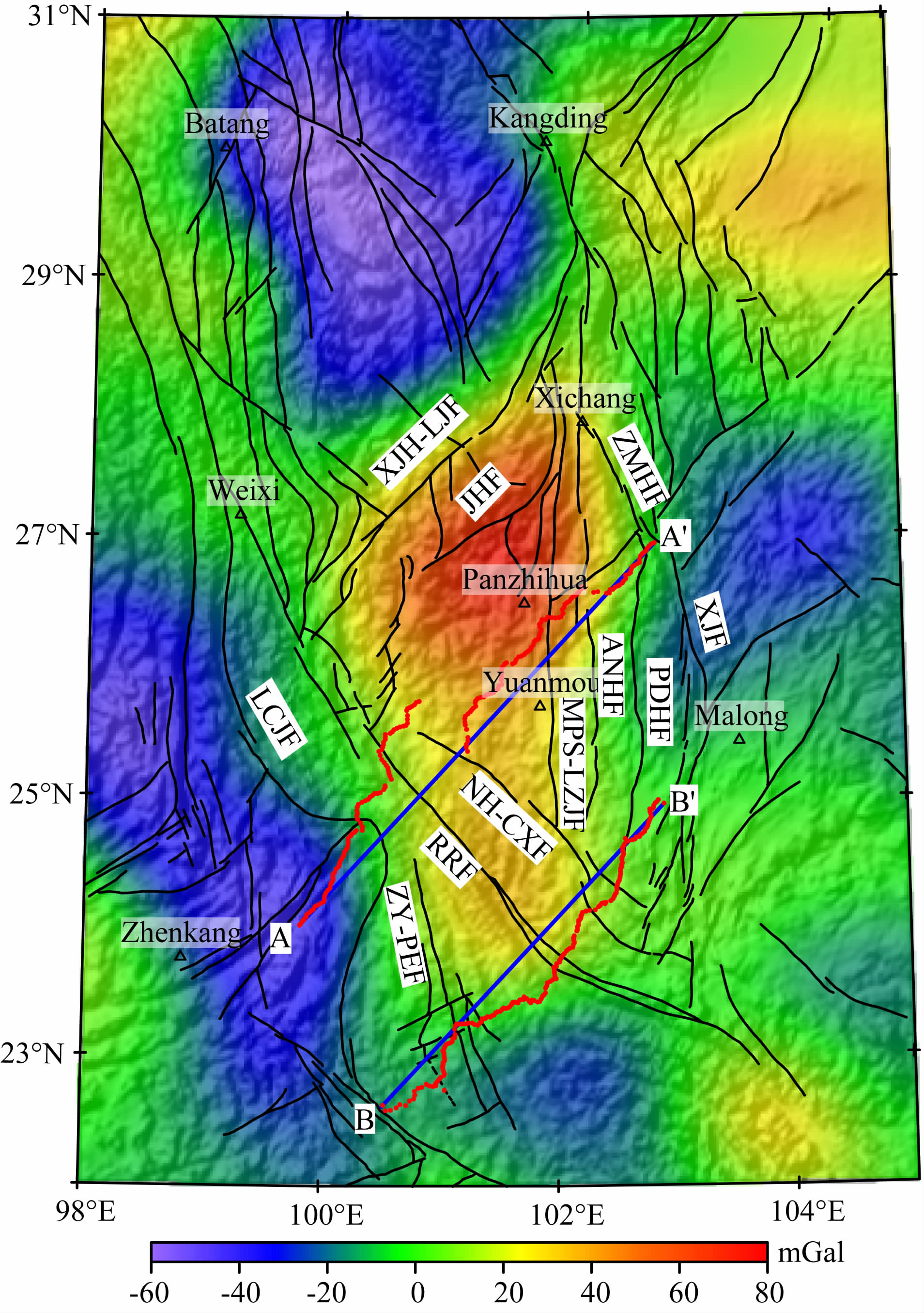
2.2 区域重力场特征为研究剖面附近较大范围的攀西地区地壳深部结构,需进行区域重力异常场的研究.因此,本文选取98°E—105°E,22°N—31°N为研究区来进行整体性研究.图 3为收集自中国地质调查局的研究区1 ∶ 100万布格重力异常,点、线间距均为10 km.
 |
图 3 研究区布格重力异常图 Fig. 3 Bouguer gravity anomaly of the study area |
研究区布格重力异常总的变化趋势是由东向西,由南向北重力值逐渐降低.东部四川盆地重力值 最大为-40 mGal,而北西侧松潘—甘孜地块内的巴塘地区,重力值最小为-540 mGal,相对变化约500 mGal.全区布格重力异常以北东走向,纵贯全区的龙门山—锦屏山巨型重力梯级带为界,分为东西两大区.
西部松潘—甘孜地块重力场变化平缓,在-330~-540 mGal 间变化,等值线较疏缓,该区中生代海相地层厚达10余公里,且有大量的印支—燕山期酸性花岗岩体分布(许志琴等,1992).重力场反映出该区曾经是凹陷区,接受了巨厚沉积,地壳厚度大,无高密度体引起重力异常高.梯级带以东华南褶皱系的布格重力异常比较复杂,显示出两种区域特征.四川盆地布格重力异常值平缓下降,等值线向西突出,反映出稳定块体的重力场特征.攀西地区则是叠加在负值重力异常背景上的相对重力高值区,平面上呈南宽北窄的楔形,北端收敛于石棉附近.
3 地壳密度结构反演 3.1 剖面重力建模在重力剖面模拟解释中,首先依据重力场的变化特征分析引起变化的主要因素,结合研究区区域地质构造和其他地球物理方法研究成果建立剖面初始密度模型,进行定性解释;然后根据测区内物性资料进行定量计算,采用任意截面二度体重力异常计算公式正演密度模型的理论重力异常(Talwani et al.,1959),人机交互反复修改模型,直到计算重力异常与实测重力异常的拟合误差小于剖面布格重力异常精度时为止,建立最终的密度模型.
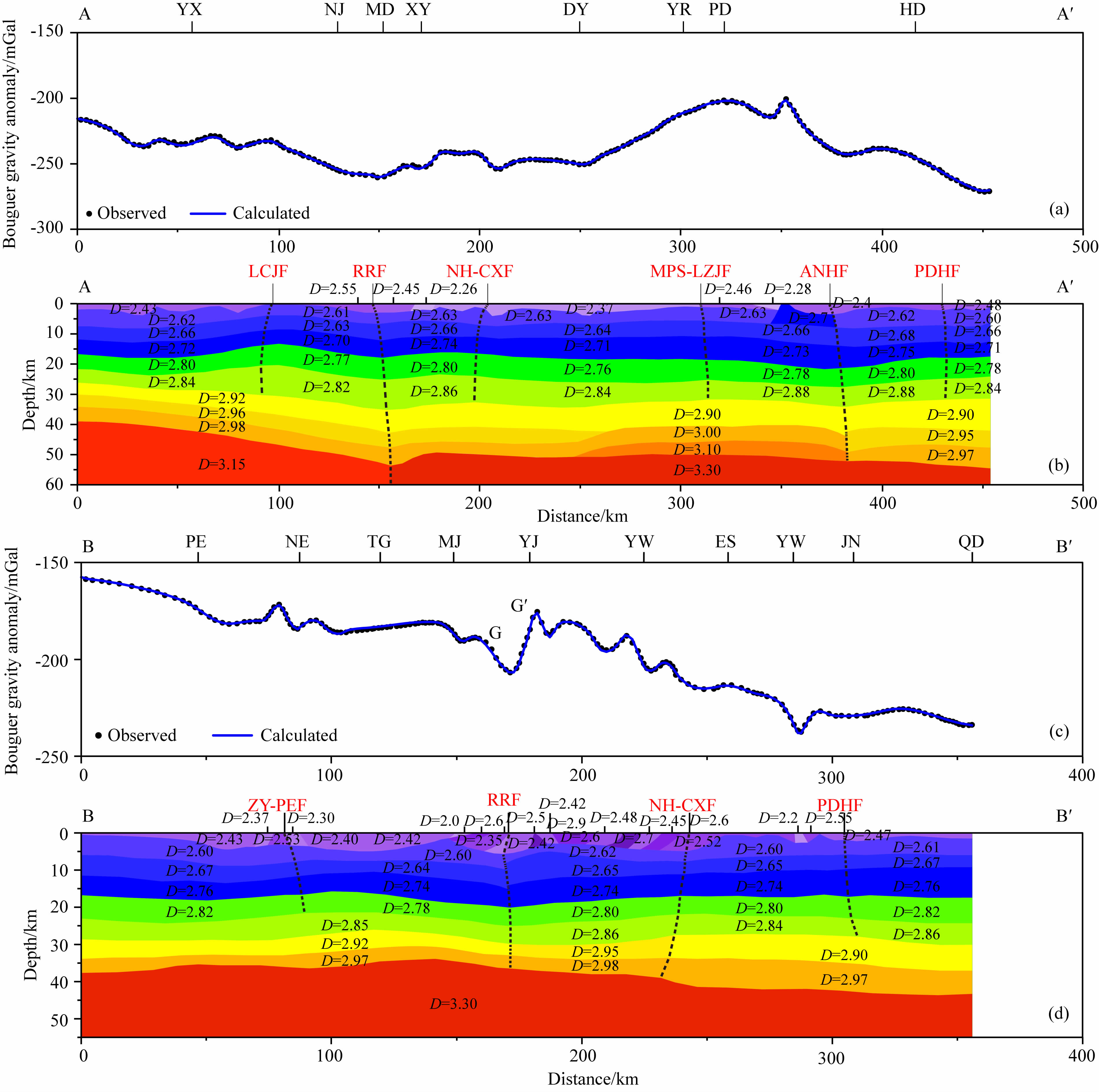
中国地震局于20世纪80年代在云南地区开展了一系列人工地震剖面探测工作,其中孟连—思茅—马龙剖面与本次重力测量工作中的B-B′剖面重合.白志明等(2004)对地震剖面进行了重新解释,给出剖面上P波速度模型.我们利用P波速度-密度 经验公式ρ=a+bvP(Christensen and Mooney,1995)进行转换得到相应的密度,其中a=0.5406 g·cm-3、 b=0.3601 g·s/km·cm3,建立了沿B-B′剖面的初始密度模型.由于没有与A-A′剖面重合的人工地震 资料,本文在构建该剖面初始密度模型时以Crust1.0 模型(Laske et al.,2013)为参考.在此基础上,对实测的两条剖面上的布格重力异常进行了正反演计算,经过多次调整模型方案,最终选择了计算重力场与实际重力场分布最佳拟合的模型给出两条剖面的二维地壳密度结构,如图 4所示.
 |
图 4 重力剖面地壳上地幔密度结构(a)为剖面A-A′观测与拟合重力异常,黑点为实测布格重力异常,蓝线为拟合重力异常;(b)为剖面A-A′地壳上地幔密度模型;(c)为剖面B-B′观测与拟合重力异常;(d)为剖面B-B′地壳上地幔密度模型. Fig. 4 Density models of the crust-mantle structure beneath the profile A-A′ and B-B′(a)presents Bouguer gravity anomalies(black dot) and calculated anomalies(blue line)along profile A-A′;(b)indicates density model for profile A-A′;(c)presents Bouguer gravity anomalies(black dot) and calculated anomalies(blue line)along profile B-B′;(d)indicates density model for profile B-B′. |
在两条剖面的最终二维地壳结构和构造解释剖面中,地壳分为浅部沉积层、上地壳、中地壳和下地壳,各层密度分别为2.00~2.60 g·cm-3、2.61~ 2.76 g·cm-3、2.77~2.88 g·cm-3和2.90~ 3.00 g·cm-3,上地幔顶部密度为3.10~3.35 g·cm-3. 在密度模型中,考虑了断裂带的走滑性质,主要断裂构造的产状都比较陡.
在A-A′剖面密度模型上(图 4a,图 4b),红河断裂带两侧密度结构存在较大差异,西部平均密度明显低于断裂带东侧,断裂带深部莫霍面存在一定程度的凹陷,推测为新生代早期红河断裂带张开过程的结果(Tapponnier et al.,1990; 张进江等,2006).大姚—会东段下地壳底部存在密度较高的壳幔过渡层,引起了该地区大尺度的重力高异常.过去重力资料将这一高异常解释为莫霍面隆起(刘云龙等,1987; 钟锴等,2005),但根据人工地震(Kan et al.,1986; 熊绍柏等,1986; 崔作舟等,1987)和新的重力资料分析解释,我们认为引起重力高异常的原因不是莫霍面隆起,而是地壳底部存在着密度较高的壳幔过渡层,与这一地区地表出露的基性、超基性岩石一样都是在地幔柱活动地区或大火成岩省常见的岩浆底侵作用(Cox,1989; Liu et al.,2001).
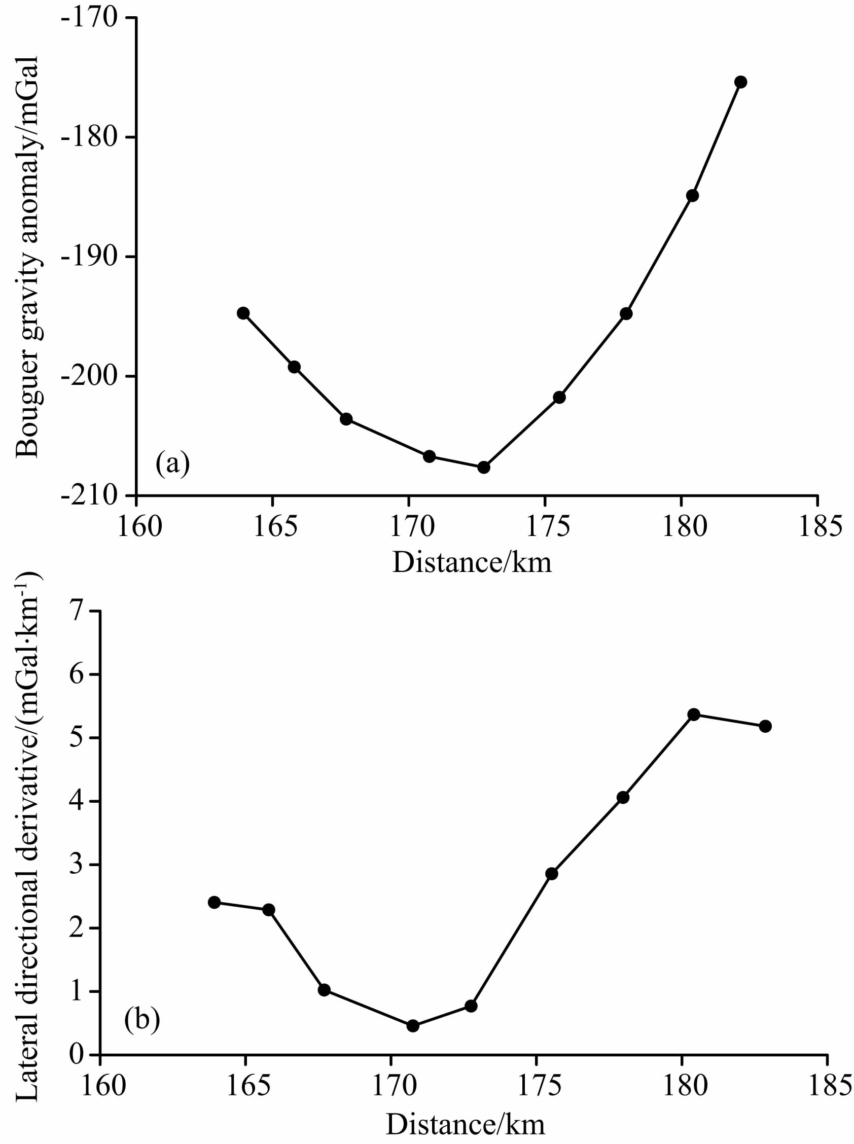
B-B′剖面密度模型中(图 4c,图 4d),红河断裂带两侧密度结构比较一致,对应的莫霍面起伏也较小,不存在明显变化,显示出红河断裂带沿走向的构造变化.G-G′段显示了整条剖面上布格重力异常变化最为剧烈的地方,即在18 km范围内重力场由-195 mGal增加至-175 mGal,红河断裂带的位置恰好处于该重力异常突跃段内.为确定红河断裂带的位置和构造形态,对G-G′段重力异常进行了水平方向导数处理,得到该异常段水平导数Vxz的异常分布特征,如图 5所示.由图 5b可见,Vxz曲线呈凹谷型分布,凹谷的西侧较东侧呈现出相对平缓的分布态势,最低值在剖面90号测点约171 km处.根据重力学理论,倾斜断裂的位置应与其水平导数最低值位置一致,且倾斜断裂的倾向与水平导数相对平缓的一侧相同(王谦身等,2003,2013).因此,我们认为红河断裂带浅部向西倾斜,倾角约为70°~80°,而深部则转为近于陡直向东倾斜,与人工地震剖面认识一致(白志明和王椿镛,2004).推测红河断裂带以西哀牢山重力低异常为低密度地层加厚,哀牢山变质岩逆冲到低密度沉积盖层上所致(Yin and Harrison,1996; Hou et al.,2013),而断裂带东部高重力异常对应于前寒武纪基底隆起和广泛出露的晚二叠系峨眉山玄武岩(宋谢炎等,2002; Marian et al.,2013).
 |
图 5 B-B′剖面上G-G′段重力异常的水平方向导数 Fig. 5 Lateral directional derivative of gravity anomalies on G-G′ section in profile B-B′ |
视密度填图可为划分岩性、圈定岩体边界以及解决有关地质构造等问题提供密度分布依据.为进一步研究攀西地区下地壳底部壳幔过渡层的密度分布特征,本文从研究区区域布格重力异常中分离出下地壳重力异常,并作视密度填图.
首先,对研究区布格重力异常进行沉积层校正(Zhou et al.,2006),消除低密度沉积层对重力异常的影响.然后,对ChinArray项目远震接收函数H-k叠加得到的地壳厚度数据进行处理,获得研究区莫霍面深度模型并进行重力异常正演,进而剥离莫霍面异常,去除莫霍面起伏的重力影响,以得到反映地壳密度横向不均匀分布的地壳重力异常.最后,采用优化滤波法(Meng et al.,2009; Guo et al.,2013)对研究区地壳重力异常进行分离处理,结合径向对数功率谱分段拟合法(图 6)提取出视深度层为35~45 km的下地壳重力异常,如图 7所示.
 |
图 6 研究区布格重力异常功率谱曲线及深度估计,其中曲线为重力异常的径向对数功率谱,直线为视密度层深度对应的径向频率范围的拟合直线. Fig. 6 The radial logarithm power spectrum(curve)of the Bouguer gravity anomaly and the estimation of the interface depth. The straight line is the fitting line within the power spectrum range corresponding to the interface depth. |
 |
图 7 研究区视密度层35~45 km的下地壳重力异常 Fig. 7 Lower crust gravity anomaly for 35~45 km apparent density layer of the study area |
研究区下地壳重力异常总的变化趋势是由南东至北西逐渐减小,松潘—甘孜地块重力异常值最小为-60 mGal,而攀西地区的攀枝花附近重力异常值最大为80 mGal,相对变化约140 mGal,四川盆地同样表现为正的重力异常.红河断裂带西北段两侧 重力异常差异较大,正负异常相对变化超过100 mGal,而东南段两侧异常基本一致,均处于20~40 mGal之间,推测红河断裂带西北段地震活动性强,东南段地震活动性较弱的原因可能与这一构造差异有关(王夫运等,2014).
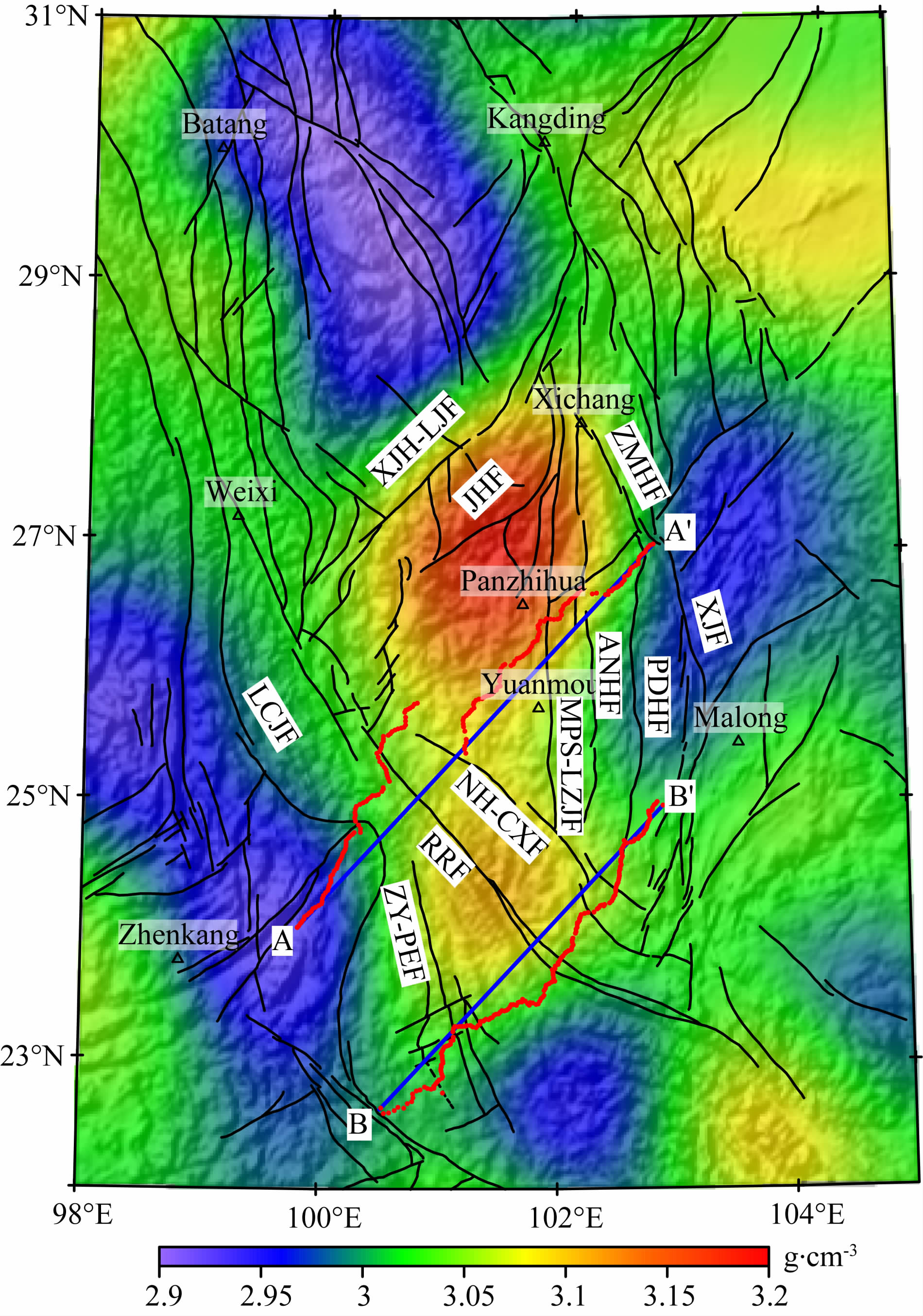
本文采用频率域视密度填图方法(王谦身等,2003)对上述下地壳重力异常进行反演,其中,密度 层上界面深度选为35 km,下界面深度选为45 km.经过6次迭代反演,得到研究区深度层为35~45 km的下地壳视密度分布,如图 8所示.
 |
图 8 研究区下地壳重力异常视密度填图结果 Fig. 8 Apparent density mapping of the lower crust gravity anomaly |
由图 8我们可以得出,攀西地区下地壳底部壳幔过渡层分布东西分别以则木河断裂带和小金河—丽江断裂带为界,北自四川省西昌,南至云南省元谋附近,与剖面二维地壳密度结构模拟反演结果一致,只在A-A′剖面下地壳底部存在高密度壳幔过渡层,而在研究区以南的B-B′剖面下地壳底部并不存在这一高密度体.红河断裂带北西段两侧密度结构差异显著,变化超过0.2 g·cm-3,而东南段两侧密度结构基本一致,这一沿走向的显著构造变化也与重力异常特征相同.
进一步我们还可以看出,在印度板块持续北东向推挤的作用下,青藏高原物质发生东向转移,南北地震带南段经历了强烈的变形和断裂作用,四川盆地高密度块体阻挡了青藏高原东部物质向四川盆地下方流动,进而向东南方向转移,流向密度相对较弱的华南褶皱系.根据本文研究结果,滇中次级块体与华南褶皱系的密度边界为普渡河断裂带,而不是以东的重力异常分界线——小江断裂带.
4 结论与讨论(1)两条剖面上红河断裂带两侧的布格重力异常特征均存在明显差异.剖面A-A′红河断裂带东侧存在一个较大范围的重力高异常,这个异常是滇中次级块体重力高异常的一部分.剖面B-B′红河断裂 带的位置并不处于地形最低点处,而是元江以西剖面90号测点附近(约171 km),局部异常最低点与地形最低点之间有约12 km的偏移.
(2)研究区区域重力异常由南东到北西逐渐减小,相对变化达500 mGal.全区布格重力异常以龙门山—锦屏山巨型重力梯级带为界,分为东西两大区.西部松潘—甘孜地块重力场变化平缓,等值线较疏缓,无高密度体引起重力异常高.梯级带以东华南褶皱系的布格重力异常比较复杂,四川盆地是一个等值线向西突出的异常缓降区,攀西地区则是叠加在负值重力异常背景上的相对重力高值区.
(3)在A-A′剖面密度模型上,红河断裂带西侧平均密度明显低于东侧,由于新生代早期红河断裂带张开过程的作用,使断裂带深部莫霍面存在一定程度的起伏.B-B′剖面红河断裂带两侧密度结构比较一致,对应的莫霍面不存在明显变化.红河断裂带这一南北向结构差异,显示出断裂带沿走向的构造变化,推测与其西北段地震发生频度较高、东南段地震鲜有发生且震源深度较浅(王夫运等,2014)的地震活动分布情况有关.
(4)通过对人工地震和新的重力资料进行分析,本文认为A-A′剖面大姚—会东段引起重力高异常的原因不是莫霍面隆起,而是地壳底部存在着密度较高的壳幔过渡层.攀西构造带走向为近南北向,而北东向的剖面与该构造带成约45°斜交,因此剖面上重力异常不能简单当作沿东西方向展布的二度场源产生的重力异常来解释,下地壳底部壳幔过渡层拟合结果水平方向可能被拉长.Liu等(2001)通过天然地震层析成像技术也得出与本文相似结论,认为在攀西地区下地壳底部—上地幔顶部有一厚20 km的地幔物质侵入附加层.
(5)为进一步研究攀西地区下地壳底部壳幔过渡层的密度分布特征,本文从研究区布格重力异常中分离出下地壳重力异常并作视密度填图.攀西地区下地壳底部壳幔过渡层分布远超过“攀西裂谷”的范围,因此我们认为这一下地壳底部壳幔过渡层不是攀西裂谷下的“裂谷垫”,而是与该区地表广泛出露的基性、超基性岩石一样都是在地幔柱活动地区或大火成岩省常见的岩浆底侵作用(Cox,1989; Liu et al.,2001).
| [1] | Bai Z M, Wang C Y. 2004. Tomography research of the Zhefang-Binchuan and Menglian-Malong wide-angle seismic profiles in Yunnan province. Chinese J. Geophys. (in Chinese), 47(2): 257-267. |
| [2] | Chen G D, et al. 1965. China Tectonic Issues (in Chinese). Beijing: Science Press. |
| [3] | Chen S, Wang Q S, Zhu Y Q, et al. 2011. Temporal and spatial features of isostasy anomaly using gravitational admittance model at eastern margin of Tibetan Plateau. Chinese J. Geophys. (in Chinese), 54(1): 22-34, doi: 10.3969/j.issn.0001-5733.2011.01.004. |
| [4] | Christensen N I, Mooney W D. 1995. Seismic velocity structure and composition of the continental crust: a global view. J. Geophys. Res., 100(B6): 9761-9788, doi: 10.1029/95JB00259. |
| [5] | Cox K G. 1989. The role of mantle plumes in the development of continental drainage patterns. Nature, 342(6252): 873-877, doi: 10.1038/342873a0. |
| [6] | Cui Z Z, Lu D Y, Chen J P, et al. 1987. The deep structural and tectonic features of the crust in Panxi area. Chinese J. Geophys. (Acta Geophysica Sinica) (in Chinese), 30(6): 566-580. |
| [7] | Guo L H, Meng X H, Chen Z X, et al. 2013. Preferential filtering for gravity anomaly separation. Computers and Geosciences, 51: 247-254, doi: 10.1016/j.cageo.2012.09.012. |
| [8] | He Z Q, Hu G, Lu L Y, et al. 2013. The shallow velocity structure for the Tonghai basin in Yunnan. Chinese J. Geophys. (in Chinese), 56(11): 3819-3827, doi: 10.6038/cjg20131123. |
| [9] | Hou T, Zhang Z C, Encarnacion J, et al. 2013. The role of recycled oceanic crust in magmatism and metallogeny: Os-Sr-Nd isotopes, U-Pb geochronology and geochemistry of picritic dykes in the Panzhihua giant Fe-Ti oxide deposit, central Emeishan large igneous province, SW China. Contrib. Mineral. Petrol., 165(4): 805-822, doi: 10.1007/s00410-012-0836-3. |
| [10] | Huang J Q. 1954. Major Geotectonic Units in China (in Chinese). Beijing: Geological Publishing House. |
| [11] | Jian P, Liu D Y, Kröner A, et al. 2009. Devonian to Permian plate tectonic cycle of the Paleo-Tethys Orogen in southwest China (II): insights from zircon ages of ophiolites, arc/back-arc assemblages and within-plate igneous rocks and generation of the Emeishan CFB province. Lithos, 113(3-4): 767-784, doi: 10.1016/j.lithos.2009.04.006. |
| [12] | Jiang F Z, Fang J. 2001. Gravity field separation, density inversion and crustal tectonics in Kang-Dian region. Acta Seismologica Sinica (in Chinese), 23(4) : 391-397. |
| [13] | Kan R J, Hu H X, Zeng R S, et al. 1986. Crustal structure of Yunnan Province, People's Republic of China, from seismic refraction profiles. Science, 234(4775): 433-437, doi: 10.1126/science.234.4775.433. |
| [14] | Laske G, Masters G, Ma Z T, et al. 2013. Update on CRUST1.0 —A 1-degree Global Model of Earth's Crust. Geophys. Res. Abstracts, 15(Abstract EGU2013-2658). |
| [15] | Li S G. 1973. Introduction to Geomechanics (in Chinese). Beijing: Science Press. |
| [16] | Liu F R. 1984. On the question of the "Panzhihua-Xichang rift valley belt". Nature Exploration (in Chinese), (1): 57-63. |
| [17] | Liu J H, Liu F T, He J K, et al. 2001. Study of seismic tomography in Panxi paleorift area of southwestern China. Science in China Series D: Earth Sciences, 44(3): 277-288. |
| [18] | Liu Y L, Wu C Z, Zheng J C. 1987. Gravity anomaly features of Panxi rift and research on its issues. // Zhang Y X, Liu B G. Collections of Panxi rift, China 3 (in Chinese). Beijing: Geological Publishing House, 90-98. |
| [19] | Lou H, Wang C Y. 2005. Wavelet analysis and interpretation of gravity data in Sichuan-Yunnan region, China. Acta Seismologica Sinica (in Chinese), 27(5): 515-523. |
| [20] | Luo Y N. 1983. The evolution of paleoplates in the Kang-Dian tectonic zone. Earth Science-Journal of Wuhan College of Geology (in Chinese), (3): 93-102. |
| [21] | Marian M, Yao Y, Allan H W, et al. 2013. Panxi region (South-West China): Tectonics, magmatism and metallogenesis. A review. Tectonophysics, 608: 51-71, doi: 10.1016/j.tecto.2013.09.008. |
| [22] | Meng L S, Zeng Q Y, Lu L R, et al. 1987. Study on isostatic anomalies of gravity in Panxi area. // Zhang Y X, Liu B G. Collections of Panxi rift, China 3 (in Chinese). Beijing: Geological Publishing House, 99-109. |
| [23] | Meng X H, Guo L H, Chen Z X, et al. 2009. A method for gravity anomaly separation based on preferential continuation and its application. Applied Geophysics, 6(3): 217-225, doi: 10.1007/s11770-009-0025-y. |
| [24] | Miu Y K, Ren Z D, Chen X Y, et al. 1986. Tectonic environment and tectonic development of Panxi rift in Sichuan. Earth Science-Journal of Wuhan College of Geology (in Chinese), 11(6): 631-637. |
| [25] | Shellnutt J G, Zhou M F. 2007. Permian peralkaline, peraluminous and metaluminous A-type granites in the Panxi district, SW China: Their relationship to the Emeishan mantle plume. Chemical Geology, 243(3-4): 286-316, doi: 10.1016/j.chemgeo.2007.05.022. |
| [26] | Song X Y, Hou Z Q, Wang Y L, et al. 2002. The mantle plume features of Emeishan basalts. J. Mineral. Petrol. (in Chinese), 22(4): 27-32. |
| [27] | Talwani M, Worzel J L, Landisman M. 1959. Rapid gravity computations for two-dimensional bodies with application to the Mendocino submarine fracture zone. J. Geophys. Res., 64(1): 49-59, doi: 10.1029/JZ064i001p00049. |
| [28] | Tapponnier P, Lacassin R, Leloup P H, et al. 1990. The Ailao Shan/Red River metamorphic belt: Tertiary left-lateral shear between Indochina and South China. Nature, 343(6257): 431-437, doi: 10.1038/343431a0. |
| [29] | Teng J W. 1987. Panzhihua-Xichang ancient rift and "activited" geophysical features. Chinese J. Geophys. (Acta Geophysica Sinica) (in Chinese), 30(6): 581-593. |
| [30] | Wang F Y, Pan S Z, Liu L, et al. 2014. Wide angle seismic exploration of Yuxi-Lincang profile-The research of crustal structure of the red river fault zone and southern Yunnan. Chinese J. Geophys. (in Chinese), 57(10): 3247-3258, doi: 10.6038/cjg20141013. |
| [31] | Wang Q S, An Y L, Zhang C J, et al. 2003. Gravitology (in Chinese). Beijing: Seismological Press. |
| [32] | Wang Q S, Teng J W, Wang G J, et al. 2007. The correction for special pattern of Bouguer gravity anomaly in Heng Duan Mts area by using satellite gravity. Progress in Geophysics (in Chinese), 22(2): 345-352. |
| [33] | Wang Q S, Teng J W, Zhang Y Q, et al. 2013. Discussion on the special gravity field across the north part of Middle Qinling Mt. Chinese J. Geophys. (in Chinese), 56(3): 792-798, doi: 10.6038/cjg20130308. |
| [34] | Xiong S B, Teng J W, Yin Z X, et al. 1986. Explosion seismological study of the structure of the crust and upper mantle at southern part of the Panxi tectonic belt. Chinese J. Geophys. (Acta Geophysica Sinica) (in Chinese), 29(3): 235-244. |
| [35] | Xu Z Q, Hou L W, Wang Z X, et al. 1992. Orogenic processes of the Songpan-Ganze orogenic belt of China (in Chinese). Beijing: Geological Publishing House. |
| [36] | Yan X F. 1981. The deep geological structure of Yunnan and its adjacent areas. Acta Geologica Sinica (in Chinese), (1): 20-28. |
| [37] | Yin A, Harrison T M. 1996. The Tectonic Evolution of Asia. New York: Cambridge University Press, 208-226. |
| [38] | Zhang E H, Lou H, Jia S X, et al. 2013. The deep crust structure characteristics beneath western Yunnan. Chinese J. Geophys. (in Chinese), 56(6): 1915-1927, doi: 10.6038/cjg20130614. |
| [39] | Zhang J J, Zhong D L, Sang H Q, et al. 2006. Structural and geochronological evidence for multiple episodes of deformation since paleocene along the Ailao Shan-Red river shear zone, southeastern Asia. Chinese Journal of Geology (in Chinese), 41(2): 291-310, doi: 10.3321/j.issn:0563-5020.2006.02.011. |
| [40] | Zhang W Y, Wu G Y. 1982. Rift Structure and Its Mineralizing Action (in Chinese). Beijing: China Academic Journals Electronic Publishing House. |
| [41] | Zhong K, Xu M J, Wang L S, et al. 2005. Study on characteristics of gravity field and crustal deformation in Sichuan-Yunnan region. Geological Journal of China Universities (in Chinese), 11(1) : 111-117. |
| [42] | Zhou M F, Yan D P, Wang C L, et al. 2006. Subduction-related origin of the 750 Ma Xuelongbao adakitic complex (Sichuan Province, China): Implications for the tectonic setting of the giant Neoproterozoic magmatic event in South China. Earth and Planetary Science Letters, 248(1-2): 286-300, doi: 10.1016/j.epsl.2006.05.032. |
| [43] | Zhu S L, Gan J S, Xu J S, et al. 1994. Three dimensional inversion of gravity anomalies in the western Yunnan. Crustal Deformation and Earthquake (in Chinese), 14(1): 1-10. |
| [44] | 白志明, 王椿镛. 2004. 云南遮放—宾川和孟连—马龙宽角地震剖面的层析成像研究. 地球物理学报, 47(2): 257-267. |
| [45] | 陈国达等. 1965. 中国大地构造问题. 北京: 科学出版社. |
| [46] | 陈石, 王谦身, 祝意青等. 2011. 青藏高原东缘重力导纳模型均衡异常时空特征. 地球物理学报, 54(1): 22-34, doi: 10.3969/j.issn.0001-5733.2011.01.004. |
| [47] | 崔作舟, 卢德源, 陈纪平等. 1987. 攀西地区的深部地壳结构与构造. 地球物理学报, 30(6) : 566-580. |
| [48] | 何正勤, 胡刚, 鲁来玉等. 2013. 云南通海盆地的浅层速度结构. 地球物理学报, 56(11): 3819-3827, doi: 10.6038/cjg20131123. |
| [49] | 黄汲清. 1954. 中国主要地质构造单元. 北京: 地质出版社. |
| [50] | 蒋福珍, 方剑. 2001. 康滇地区重力场分离、密度反演与地壳构造. 地震学报, 23(4) : 391-397. |
| [51] | 李四光. 1973. 地质力学概论. 北京: 科学出版社. |
| [52] | 刘风仁. 1984. “攀枝花—西昌裂谷带”质疑. 大自然探索, (1): 57-63. |
| [53] | 刘云龙, 武传珍, 郑建昌. 1987. 攀西地区的重力异常特征及裂谷问题研究. ∥ 张云湘, 刘秉光. 中国攀西裂谷文集3. 北京: 地质出版社, 90-98. |
| [54] | 楼海, 王椿镛. 2005. 川滇地区重力异常的小波分解与解释. 地震学报, 27(5): 515-523. |
| [55] | 骆耀南. 1983. 康滇构造带的古板块历史演化. 地球科学——武汉地质学院学报, (3): 93-102. |
| [56] | 孟令顺, 曾庆益, 卢履仁等. 1987. 攀西地区重力均衡异常的研究. ∥ 张云湘, 刘秉光. 中国攀西裂谷文集 3. 北京: 地质出版社, 99-109. |
| [57] | 缪以琨, 任祖德, 陈小源等. 1986. 四川攀西裂谷的构造环境及构造发展. 地球科学, 11(6): 631-637. |
| [58] | 宋谢炎, 侯增谦, 汪云亮等. 2002. 峨眉山玄武岩的地幔热柱成因. 矿物岩石, 22(4): 27-32. |
| [59] | 滕吉文. 1987. 攀枝花—西昌古裂谷与“活化”的地球物理特征. 地球物理学报, 30(6): 581-593. |
| [60] | 王夫运, 潘素珍, 刘兰等. 2014. 玉溪—临沧剖面宽角地震探测——红河断裂带及滇南地壳结构研究. 地球物理学报, 57(10): 3247-3258, doi: 10.6038/cjg20141013. |
| [61] | 王谦身, 安玉林, 张赤军等. 2003. 重力学. 北京: 地震出版社. |
| [62] | 王谦身, 滕吉文, 王光杰等. 2007. 应用卫星重力信息对横断山系地区布格重力异常特异分布的纠正. 地球物理学进展, 22(2) : 345-352. |
| [63] | 王谦身, 滕吉文, 张永谦等. 2013. 中秦岭北侧特异重力场及其探榷. 地球物理学报, 56(3) : 792-798, doi: 10.6038/cjg20130308. |
| [64] | 熊绍柏, 滕吉文, 尹周勋等. 1986. 攀西构造带南部地壳与上地幔结构的爆炸地震研究. 地球物理学报, 29(3) : 235-244. |
| [65] | 许志琴, 侯立玮, 王宗秀等. 1992. 中国松潘—甘孜造山带的造山过程. 北京: 地质出版社. |
| [66] | 晏贤富. 1981. 云南及邻区的深部地质构造. 地质学报, (1): 20-28. |
| [67] | 张恩会, 楼海, 嘉世旭等. 2013. 云南西部地壳深部结构特征. 地球物理学报, 56(6): 1915-1927, doi: 10.6038/cjg20130614. |
| [68] | 张进江, 钟大赉, 桑海清等. 2006. 哀牢山—红河构造带古新世以来多期活动的构造和年代学证据. 地质科学, 41(2): 291-310, doi: 10.3321/j.issn:0563\-5020.2006.02.011. |
| [69] | 张文佑, 吴根耀. 1982. 裂谷构造与成矿作用. 北京: 中国学术期刊电子出版社. |
| [70] | 钟锴, 徐鸣洁, 王良书等. 2005. 川滇地区重力场特征与地壳变形研究. 高校地质学报, 11(1) : 111-117. |
| [71] | 朱思林, 甘家思, 徐菊生等. 1994. 滇西试验场区三维重力反演研究. 地壳形变与地震, 14(1): 1-10. |
 2015, Vol. 58

