 2015, Vol. 58


2. 中国地震局第一监测中心, 天津 300180
2. First Crust Monitoring and Application Center, CEA, Tianjin 300180, China
Firstly, we collected 5 sets of the GPS horizontal velocity field covering Nepal and adjacent areas, and then transformed them to an approximately unified reference frame. Secondly, we calculated GPS strain rate fields in the seismic source and its vicinity using the least square collocation method on a sphere surface, and analyzed their characteristics. Thirdly, we analyzed the dynamic changes of long baselines of IISC-LHAS, IISC-DLHA, which cross the Himalayan. Finally, the coseismic displacements were obtained through processing the GPS data of 22 April to 24 April and 26 April to 28 April, respectively.
The GPS strain rate field shows that regional compressive strain accumulated on a large scale around the Main Boundary Thrust of the Himalayan tectonic zone, and the huge earthquake occurred in the region between two high-value areas of the N-S directed strain. GPS geodesic time-series indicates the baselines across the Himalaya shortened continuously, implying continuous extrusional deformation between the Indian and the Eurasian plates. The phenomena that the shortening enhanced after the year 2012 reflects the extruding force from the Indian plate has been strengthened. The co-seismic displacements recorded by the permanent GPS stations in Tibet neighboring Nepal are dominantly directed to south, just towards the epicenter, likely resulting from the release of thrust strain in southern Tibet.
From the feature of pre-seismic and coseismic crustal deformation of the Nepal great shock, we suggest that both its seismogenic and co-seismic strain release areas are relatively large, which would generate long-term impact on the Tibetan Plateau, such as dynamic adjustment in the crust or even to trigger unlocking of the Himalayan thrusts to spawn big quakes.
北京时间2015年4月25日14时11分,尼泊 尔发生Mw7.8地震(震中位置84.708°E,28.147°N,节面I:走向295°,倾向11°,倾角108°,节面II:走向96°,倾向79°,倾角87°),震源机制结果显示此次地震为典型的逆冲型破裂(USGS,2015),地震发生于喜马拉雅构造带中段,是尼泊尔国内1934年8.0级地震以来最大的一次地震.喜马拉雅构造带在印度板块和欧亚板块挤压碰撞作用下,在尼泊尔地区发育有3条主要的逆冲型断裂(图 1),从南到北依次 为喜马拉雅主前缘断裂(MFT: Main Frontal Thrust)、喜马拉雅主边界断裂(MBT: Main Boundary Thrust)和喜马拉雅主中央断裂(MCT: Main Central Thrust). 喜马拉雅主中央断裂在距今30—23 Ma已经活动,晚中新—上新世时,缩短作用向南发展到喜马拉雅主边界断裂,上新世—全新世发展到喜马拉雅主前缘断裂,喜马拉雅主边界断裂和喜马拉雅主前缘断裂晚第四纪以来仍在活动(Ponraj et al., 2010;邓起东等,2014).根据此次地震的震源机制解(http://www.globalcmt.org),主震的发震断层为喜马拉雅主边界断裂,1976年以来研究区域震源机制解分布结果(图 2)显示,主震破裂区近年来的强震活动并不显著.
 | 图 1 喜马拉雅地区断层示意(Ponraj et al., 2010) Fig.1 Schematic representation of the fault system beneath the Himalaya(Ponraj et al., 2010) |
 | 图 2 研究区域1976年以来6级以上地震震源机制分布(数据来源于http://www.globalcmt.org) Fig. 2 Distribution of focal mechanism since 1976 in the research area(M≥6) (The data are from http://www.globalcmt.org) |
由于尼泊尔及喜马拉雅地区地壳活动剧烈、地震频度和震级较高,多位学者利用GPS资料针对该区的地壳变形特征开展了深入的研究,并取得了大量有价值的成果.如Bilham 等(1997)利用1991—1995年印度、尼泊尔和西藏地区GPS观测资料给出了跨喜马拉雅的收缩速率约为18 mm·a-1;王琪等(1998)利用1992和1995年跨喜马拉雅的GPS观测资料获得了西藏南部与尼泊尔之间的相对运动速率,根据弹性位错模型推算了印度板块挤入西藏块体的速率,其结果与地质和地震资料推断青藏块体的现代地壳运动特征基本一致;Bettinelli等(2006)基于GPS流动和连续观测以及Doris资料计算了印度板块和西藏块体之间地壳缩短速率,分析了尼泊尔地区断层活动性和震间应变积累;Feldl和Bilham(2006)基于已有的GPS速度场采用位错模型分析了喜马拉雅地区的地震驱动力,结果表明喜马拉雅地区地震驱动力的范围比已有的认识(高喜马拉雅附近)更宽;Ader 等(2012)利用尼泊尔和西藏地区GPS连续数据及公开发表的GPS流动和水准数据识别了喜马拉雅主逆冲断层(MHT)的震间耦合特征,给出了尼泊尔地区跨喜马拉雅的汇聚速率并分析了该地区的地震趋势.
由于此次地震属于印度板块俯冲、碰撞欧亚大陆的动力作用结果,其孕震尺度的空间范围必然涉及印度板块与青藏高原的较大区域,同时考虑到强震破裂所释放的应变来源于震前长期的地壳运动与 变形所产生的应变积累,因此利用大空间范围的GPS观测研究地壳运动与变形的动态过程有可能为识别强震孕育阶段以及探索强震预测提供一些参考(江在森等,2009;陈光齐等,2013).鉴于此,本文首先收集了覆盖尼泊尔、印度以及青藏高原内部的5套GPS水平速度场结果,并将其融合为近似统一参考框架的结果;然后以此为基础通过GPS速度场、GPS应变率场、GPS基线时间序列等结果分析了此次地震震源区及周边区域地壳变形特征;最后基于青藏高原内部的XZBG(巴嘎)、XZAR(昂仁)、XZZB(仲巴)、XZRK(日喀则)、XZZF(珠峰)等GPS连续站给出了其远场同震位移分布,并对此次地震的影响进行了初步分析. 2 GPS资料收集与融合
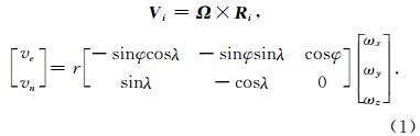
根据前人研究结果,本文收集了印度板块与青藏高原交汇地区的多套GPS速度结果(经度范围75—110°E、纬度范围15—55°N),数据的详细信息见表 1.在应用表 1结果进行地壳变形综合分析之前,首先必须完成不同来源数据参考基准的相对统一.经过分析发现,表中第1套结果(Wang et al., 2001)的分布范围较大且包含大部分IGS站点,便于与其他结果融合,因此选定为参考速度场.速度场融合的方法如下:如拟将速度场A归化到B内,认为A和B的速度差异可以用一整体旋转(刚性运动)来描述(肖根如,2011),在公共点较少的情况下该一阶近似有其合理性.根据公式(1)所示(式中 Ω 为欧拉矢量,由ωx、ωy、ωz组成; R i为测站位置矢量,用经度λ和纬度φ表示; V i为公共点的速度矢量差,包含东向速度差ve和北向速度差vn;r为地球半径),对于两套GPS速度场最少只需有3个公共点(本文假设经纬度相差不超过0.01°的两测点为公共点)即可完成融合.为了增加转换的稳定性,本文在数据融合过程中尽可能应用较多的公共点.在求解过程中,为了消除某些误差较大的公共点影响,采用“n倍中误差准则”,即设置准则(所有公共点残差绝对值小于n倍均方差).如果计算结果满足准则即退出循环,反之则删除残差绝对值大于阈值的测点,重新求解欧拉矢量,直至满足准则为止.每次归化时,调整n值,公共站数据较多时调低n值(1~2),公共站较少时则调高n值(2~3),在参与解算的测站数目和解算精度之间寻找一个最佳结果.表 1中公共点速度矢量差的残差均方差结果显示,融合后的速度残差较小(均方差均小于2 mm·a-1),表明公共点可以用公式(1)有效描述,融合结果满足研究震间变形需求,此时可忽略5种结果由于时间尺度不一致产生的差异.公式(1)为
|
|
表 1 本文使用的GPS速度场 Table 1 GPS velocity fields used in this work |
基于前文数据融合方法,图 3给出了融合后的GPS速度场分布.结果显示,在ITRF97参考框架下,喜马拉雅地区以北东向运动为主,青藏高原内部的地壳运动方向逐渐向东向偏转且量值有所减小,该结果表明青藏高原内部存在近南北向挤压应变积累且东西向断层存在左旋剪切变形背景.
 | 图 3 融合后的GPS水平速度场(ITRF97参考基准,其他图例同图 2) Fig. 3 Combined GPS horizontal velocity field in ITRF97(Other symbols are same as Fig. 2) |
相对于GPS速度场,应变率结果受参考框架影响较小,主要反映不同测点之间的相对运动情况,并且应变率场分布特征在一定程度上与地震危险性存在联系(Ward,1994).基于图 3给出的融合后GPS速度场,利用最小二乘配置球面解算方法(武艳强等,2009;江在森和刘经南,2010; Wu et al., 2011)给出了此次尼泊尔地震震源区及周边区域的GPS应变率场分布(图 4和图 5),由于GPS速度场中西南角测点较稀疏,因此图 4和图 5西南角地区的应变率结果可信度不高.
 | 图 4 GPS主应变率场分布(蓝色点代表GPS测站,其它图例同图 2) Fig. 4 Distribution of GPS principal strain rates(Blue circles denote GPS stations. Other symbols are same as Fig. 2) |
 | 图 5 GPS南北向应变率场分布(蓝色点代表GPS测站,其他图例同图 2) Fig. 5 Distribution of GPS north-south strain rates. Blue circles denote GPS stations(Other symbols are same as Fig. 2) |
图 4给出的GPS主应变率结果显示,喜马拉雅构造带存在大范围挤压应变积累,西段地区的主压应变积累以NNE向为主、东段地区以近NS方向为主;震源区附近最大主压应变方向为近南北向,与区域构造应力结果基本一致(中国地震局,2015).此外震源区附近(85°E,28°N)的主压应变率量值(4.12×10⁻⁸/a)小于喜马拉雅主边界断裂东西两侧(如东侧85°E,28°N处4.73×10-8/a,西侧82°E,29°N处4.43×10-8/a).考虑到喜马拉雅构造带的主要动力来源为印度板块的北东向俯冲、推挤,同时图 4结果表明该区的地壳变形背景以近南北向挤压为主,图 5给出了研究区域近南北向应变率结果.图 5结果表明,尼泊尔地震震源区处于东西两侧南北 向挤压应变积累高值区的过渡区域,震源区本身应变积累速率较高,但应变率梯度值不大,上述震源区处于应变积累高值过渡区特征与汶川地震处于东西向挤压应变高值区边缘的特征具有一致性(Wu et al., 2015). 3.3 GPS基线时间序列分析
GPS站间大地线(椭球面上连接两点的最短弧线)弧长作为基线长度,对GPS三维定位信息只取N(南北向)、E(东西向)信息而避免了精度较低的U 向(椭球面法向)误差影响,且GPS基线长度不受参考框架本身漂移、旋转等因素影响,可以较为客观地反映地壳相对运动变化信息(江在森等,2009).经过GPS原始数据统一融合解算,获取统一参考基准的GPS时间序列结果,图 6给出了位于印度板块内部、运动较为稳定的IISC(印度班加罗尔)至DLHA(中国德令哈)和IISC至LHAS(中国拉萨)的基线时序结果.
 | 图 6 GPS基线时间序列 (a,b)IISC-DLHA;(c,d)IISC-LHAS;(a,c)原始曲线;(b,d)去除线性趋势的曲线,黑色散点为原始值,红色直线为趋势值. Fig. 6 Time-series of GPS baselines (a,b)IISC-DLHA;(c,d)IISC-LHAS;(a,c)Original curve;(b,d)Detrended curves. Black points denote raw results. Red lines denote trend values. |
图 6结果显示跨喜马拉雅构造带的基线时间序列表现出阶段性变化特征,2012年以来的缩短增强现象反映了印度板块对青藏块体的推挤作用明显,其中IISC-DLHA基线缩短速率明显大于IISC-LHAS,表明青藏块体内部存在显著变形,考虑测点间距离差异,该结果反映了青藏块体单位尺度的北东向挤压变形速率明显大于印度板块内部. 3.4 GPS同震位移场
根据中国大陆构造环境监测网络GPS连续站在尼泊尔地震震前3天(2015年4月22—24日)和震后3天(4月26—28日)的ITRF2005下时间序列结果,图 7给出了距离震中区较近的5个测站的同震位移分布.结果显示,5个GPS连续站的同震位移均以南向运动为主且近似指向震中,反映了逆冲应变释放特征.表 2结果显示距震中约168 km的XZZF测站同震位移较大,约为34.59±3.57 mm;距震中约243 km的XZAR和XZZB测站同震位移分别约为25.25±3.61 mm和21.83±3.35 mm;距震中区更远的XZBG和XZRK测站的同震位移较小,分别为5.18±3.23 mm、6.28±2.94 mm,该结果表明同震位移分布与发震断层的走向、倾角相关,在空间上存在不一致,与地震动预测结果(中国地震局地球物理研究所,2015)较为一致.
|
|
表 2 尼泊尔Mw7.8地震GPS同震位移 Table 2 GPS co-seismic displacement of the Mw7.8 earthquake in Nepal |
 | 图 7 尼泊尔Mw7.8地震GPS同震位移分布 Fig. 7 Distribution of GPS co-seismic displacement of the Mw 7.8 earthquake in Nepal |
通过对尼泊尔地震前和同震地壳变形特征的分析,发现震前变形在时间上存在动态过程、在空间上存在非均匀性,并且震前、同震变形特征与震源破裂特性具有高度一致性.
(1)GPS基线时间序列结果显示,印度板块与欧亚板块存在持续持续挤压变形,并表现出阶段性变化特征,其中2012年以来的缩短增强现象反映了印度板块对青藏块体的推挤增强作用明显.
(2)GPS速度场和应变率场结果表明,喜马拉雅主边界断裂存在大范围挤压应变积累,震源区处于近南北向应变积累高值区的过渡区域,该特征与汶川地震处于东西向挤压应变高值区边缘的特征具有一致性.
(3)西藏地区同震位移场表明,正对断层破裂段的测站同震位移明显,在距震中约168 km处约35 mm,约240 km处达20多毫米,另两个测站距离断层破裂段较远其同震位移量值明显偏小,指向震中区的同震位移特征表明青藏高原内部逆冲型应变释放明显.
综合此次尼泊尔地震前变形和同震应变释放特征,认为此次地震的孕震区域和同震应变释放区域 均较大,将会对青藏高原的地壳变形与强震孕育产生深远影响,需引起关注重视.
致谢 感谢地壳运动监测工程研究中心提供中国大陆构造环境监测网络GPS连续站观测数据,感谢中国地震局地震预测研究所邵志刚研究员在数据融合过程中的有益讨论和两位审稿专家提出的建设性意见.| [1] | Ader T, Avouac J P, Jing L Z, et al. 2012. Convergence rate across the Nepal Himalaya and interseismic coupling on the Main Himalayan Thrust: Implications for seismic hazard. Journal of Geophysical Research, 117, B04403, doi: 10.1029/2011JB009071. |
| [2] | Bettinelli P, Avouac J P, Flouzat M, et al. 2006. Plate motion of India and interseismic strain in the Nepal Himalaya from GPS and DORIS measurements. Journal of Geodesy, 80(8-11): 567-589. |
| [3] | Bilham R, Larson K, Freymueller J. 1997. GPS measurements of present-day convergence across the Nepal Himalaya. Nature, 386(6620): 61-64. |
| [4] | Chen G Q, Wu Y Q, Jiang Z S, et al. 2013. Characteristics of seismogenic model of Mw9.0 earthquake in Tohoku, Japan reflected by GPS data. Chinese J. Geophys. (in Chinese), 53(5): 848-856, doi: 10.6038/cjg20130314. |
| [5] | Chen Q Z, Freymueller J T, Wang Q, et al. 2004. A deforming block model for the present-day tectonic of Tibet. Journal of Geophysical Research, 109 : B01403, doi: 10.1029/2002JB002151. |
| [6] | China Earthquake Administration. 2015. 《The atlas of Mw7.8 earthquake in Nepal occurred on April 25, 2015》. http://eqxiu.com/s/LXU4nA8y?eqrconde=1[2015-5-13]. |
| [7] | Deng Q D, Cheng S P, Ma J, et al. 2014. Seismic activities and earthquake potential in the Tibetan Plateau. Chinese Journal of Geophysics (in Chinese), 57(7): 2025-2042, doi: 10.6038/cjg20140701. |
| [8] | Feldl N, Bilham R. 2006. Great Himalayan earthquakes and the Tibetan plateau. Nature, 444(7116): 165-170. |
| [9] | Gan W J, Zhang P Z, Shen Z K, et al. 2007. Present-day crustal motion within the Tibetan Plateau inferred from GPS measurements. Journal of Geophysical Research, 112 : B08426, doi: 10.1029/2005JB004120. |
| [10] | Institute of Geophysics, China Earthquake Administration. 2015. 《The Mw7.8 earthquake in Nepal occurred on April 25, 2015》. http://www.cea-igp.ac.cn/tpxw/272110.shtml[2015-3-15]. |
| [11] | Jiang Z S, Fang Y, Wu Y Q, et al. 2009. The dynamic process of regional crustal movement and deformation before Wenchuan Ms8.0 earthquake. Chinese J. Geophys. (in Chinese), 52(2): 505-518. |
| [12] | Jiang Z S, Liu J N. 2010. The method in establishing strain field and velocity field of crustal movement using least squares collocation. Chinese J. Geophys. (in Chinese), 53(5): 1109-1117, doi: 10.3969/j.issn.0001-5733.2010.05.011. |
| [13] | Liang S M, Gan W J, Shen C Z, et al. 2013. Three-dimensional velocity field of present-day crustal motion of the Tibetan Plateau derived from GPS measurements. Journal of Geophysical Research: Solid Earth, 118, doi: 10.1002/2013JB010503. |
| [14] | Ponraj M, Miura S, Reddy C D, et al. 2010. Estimation of strain distribution using GPS measurements in the Kumaun region of Lesser Himalaya. Journal of Asian Earth Science, 39(6): 658-667. |
| [15] | USGS,2015. M7.8-34 km ESE of Lamjung, Nepal,http://earthquake.usgs.gov/earthquakes/eventpage/us20002926[2015-05-12]. |
| [16] | Ward S N. 1994. A multidisciplinary approach to seismic hazard in southern California. Bulletin of the Seismological Society of America, 84(5): 1293-1309. |
| [17] | Wang Q, You X Z, Wang W Y, et al. 1998. GPS measurement and current crustal movement across the Himalaya. Crustal Deformation and Earthquake (in Chinese), 18(3): 43-50. |
| [18] | Wang Q, Zhang P Z, Freymueller J T, et al. 2001. Present-day crustal deformation in China constrained by global positioning system measurements. Science, 294(5542): 574-577. |
| [19] | Wu Y Q, Jiang Z S, Yang G H, et al. 2011. Comparison of GPS strain rate computing methods and their reliability. Geophysical Journal International, 185(2): 703-717, doi: 10.1111/j.1365-246X. 2011.04976.x. |
| [20] | Wu Y Q, Jiang Z S, Yang G H, et al. 2009. The application and method of GPS strain calculation in whole mode using square collocation in sphere surface. Chinese J. Geophys. (in Chinese), 52(7): 1707-1711, doi: 10.3969.issn.00015733. |
| [21] | Wu Y Q, Jiang Z S, Zhao J, et al. 2015. Crustal deformation before the 2008 Wenchuan Ms8.0 earthquake studied using GPS data. Journal of Geodynamics, 85: 11-23. |
| [22] | Xiao G R.2011.GPS crustal deformation observations and its application in the great triangular seismotectonic[Ph.D.thesis](in Chinese). Beijing:Institute of Geology, China Earthquake Administration. |
| [23] | Zhang P Z, Deng Q D, Zhang G M, et al. 2003. Active-tectonic blocks and strong earthquakes in the continent of China. Science in China (Series D), 46(S2): 13-24. |
| [24] | 陈光齐, 武艳强, 江在森等. 2013. GPS资料反映的日本东北Mw9.0地震的孕震特征. 地球物理学报, 56(3): 848-856, doi: 10.6038/cjg20130314. |
| [25] | 邓起东, 程绍平, 马冀等. 2014. 青藏高原地震活动特征及当前地震活动形势. 地球物理学报, 57(7): 2025-2042, doi: 10.6038/cjg20140701. |
| [26] | 江在森, 方颖, 武艳强等. 2009. 汶川8.0级地震前区域地壳运动与变形动态过程. 地球物理学报, 52(2): 505-518. |
| [27] | 江在森, 刘经南. 2010. 应用最小二乘配置建立地壳运动速度场与应变场的方法. 地球物理学报, 53(5): 1109-1117, doi: 10.3969/j.issn.0001-5733.2010.05.011. |
| [28] | 王琪, 游新兆, 王文颖等. 1998. 跨喜马拉雅的GPS观测与地壳形变. 地壳形变与地震, 18(3): 43-50. |
| [29] | 武艳强, 江在森, 杨国华等. 2009. 利用最小二乘配置在球面上整体解算GPS应变场的方法及应用. 地球物理学报, 52(7): 1707-1711, doi: 10.3969.issn.00015733. |
| [30] | 肖根如.2011.GPS地壳形变观测及其在中亚大三角地震构造域的应用 [博士论文].北京:中国地震局地质研究所. |
| [31] | 张培震, 邓起东, 张国民等. 2003. 中国大陆的强震活动与活动地块. 中国科学(D辑), 33(S1): 12-20. |
| [32] | 中国地震局. 2015. 《2015年4月25日尼泊尔8.1级地震图集》. http:∥eqxiu.com/s/LXU4nA8y?eqrconde=1[2015-5-13]. |
| [33] | 中国地震局地球物理研究所. 2015. 《2015年4月25日尼泊尔8.1级地震》. http:∥www.cea-igp.ac.cn/tpxw/272110.shtml[2015-5-13]. |