To solve the problems above, this work combined the paleoseismological trenching and calculation of numerical simulation. The paleoseismological trench excavation revealed the paleoearthquake history in Holocene as well as the status of the NFZ. On the other hand, utilizing the coseismic slip distribution models of the Jinggu earthquake, the static Coulomb stress perturbations on surrounding faults, especially the NFZ, were calculated. Integrating these studies, the seismic potential of the NFZ was further analyzed.
Through the paleoseismological trench on the northern segment of the NFZ, we determined a paleoearthquake that generated surface ruptures in Holocene with a magnitude no less than 7. Using radiocarbon dating, the age of this event is constrained to be between 900 AD and 1480 AD, indicating an elapsed time of 535-1115 years. Utilizing two coseismic slip distribution models, our results show that the static Coulomb stress perturbations triggered by the Jinggu earthquake on neighboring faults, such as the Lancangjiang fault and Jinggu fault, are obviously positive, up to ~90 kPa. While on farther faults, such as the NFZ, Longling-Lancang fault zone, and Wuliangshan fault zone, the increased values are less than 10 kPa. The distribution of the stress perturbation on the fault plane of the NFZ, further computed using different fault parameters, illustrates that the maximum change of stress occurs near the surface at 24.15°N and decreases along the strike and depth. The maximum change of static Coulomb stress on the west branch of the NFZ is 0.89 kPa and the value on the east branch is 1.18 kPa.
Combining the slip rate and elapsed time since the latest paleoseismic event, it is estimated that the slip accumulated on the northern segment of the NFZ could be 2.8+1.5/-1.0 m. Further using the empirical scaling laws between magnitude and displacement, an earthquake with magnitude of 7.5+0.1/-0.2 would be generated by the accumulated slip. Although the change of static Coulomb stress triggered by the Jinggu earthquake indicates that the earthquake does not necessarily produce a sudden acceleration on the seismic risk of the NFZ, under the consideration of that the northern segment of the NFZ has accumulated seismic energy equivalent to M≈7.5, it is suggested that this fault segment will probably be in a high seismic risk with positive stress perturbation from the Jinggu earthquake.
据中国地震台网中心测定,北京时间2014年10月7日21时49分,在云南省普洱市景谷傣族彝族自治县发生了MS6.6地震,简称景谷地震,震中位于23.4°N,100.5°E,震源深度5 km(http://www.cenc.ac.cn/publish/cenc/904/20141007215911163239744/index.html),随后在12月6日又在原震区相继发生了MS5.8和MS5.9强余震.另据美国地质调查局测定,景谷地震震中位于23.386°N,100.487°E,震源深度10.9 km,矩震级(MW)为6.1级,其地震矩张量解指示两个可能的断层节面(I:走向334°,倾角83°,滑动角-169°;II:走向242°,倾角79°,滑动角-7°)(http://earthquake.usgs.gov/earthquakes/eventpage/usb000sjim # scientific),两次强余震的矩震级均为MW5.6.根据中国地震局发布的地震烈度图,景谷地震的最高烈度为VIII度,等震线长轴方向总体呈NW向(http://www.cea.gov.cn/publish/dizhenj/464/478/20141011091458652940205/index.html).中国地震局地球物理研究所对余震序列重新定位的结果显示,景谷地震的余震总体呈NW向分布,展布较窄,倾角较陡,符合走滑型地震的余震分布特征;同时对地震破裂过程的反演结果显示,破裂滑动面走向约151°,倾角约90°(http://www.cea-igp.ac.cn/tpxw/270908.shtml).因此基本可以判定该次地震是NW向断层上的走滑型地震.
景谷地震所在的滇西南块体是现今中国地震活动最频繁的活动块体之一,是南北地震带的南段,自20世纪以来多次发生6级以上地震,目前正处于一次新的地震活跃期(邓起东等,2014).历史地震记录(中国地震局,1995,1999)和仪器地震记录(中国地震台网中心,2015)显示,滇西南块体及周边的地震活动主要分布在块体内部新生的龙陵—澜沧断裂带(虢顺民等,2000; Guo et al.,2000)和川滇菱形块体的南部,呈环形分布,中间几乎没有5级以上的地震发生,构成了一个地震空区,本次景谷地震即发生在该地震空区内(图 1).
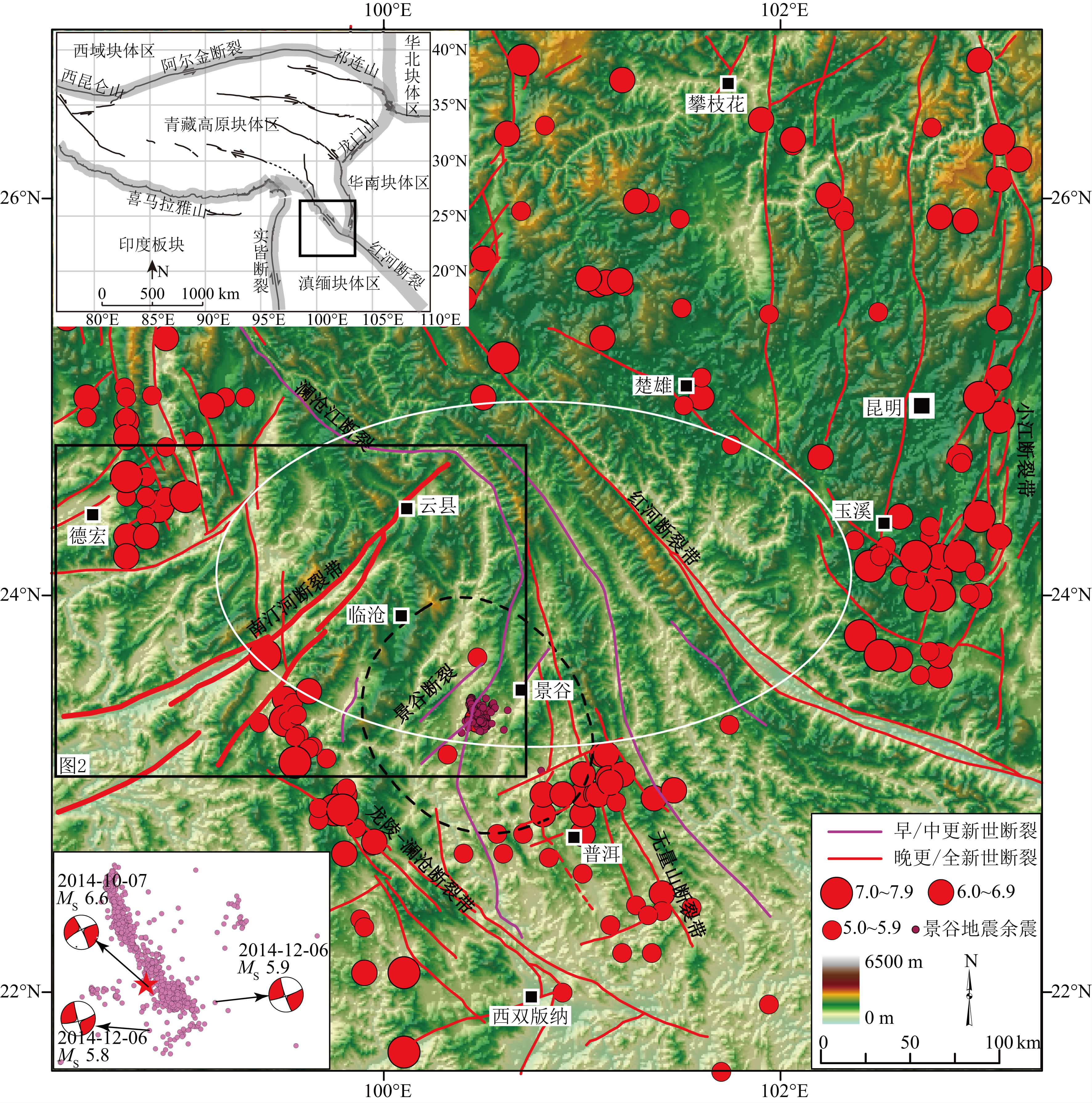 |
图 1 景谷地震区域活动构造图 红色和紫色线段分别表示晚更新世活动断裂和早中更新世断裂(邓起东,2007),红色圆点表示历史地震(中国地震局,1995,1999)和仪器记录地震(中国地震台网中心,2015),粉色圆点为景谷地震重定位余震(资料来自于中国地震局地球物理研究所房立华博士),白色椭圆圈表示地震空区范围,黑色方框指示图 2位置,黑色虚线圆圈表示景谷地震VI度烈度区范围.左上插图为青藏高原及周边主要构造块体区(修改自Zhang et al.,2003),黑色方框表示图 1位置.左下插图是景谷地震余震分布和矩张量解(来自美国地质调查局,USGS). Fig. 1 Regional tectonic map around the Jinggu earthquake Red lines indicate late-Pleistocene and Holocene active faults,whereas purple lines indicate early- and mid-Pleistocene faults(Deng,2007). Red dots represent historical earthquakes(China Earthquake Administration,1995,1999) and instrumentally recorded earthquakes(China Earthquake Networks Center,2015),while pink dots indicate the relocated aftershocks of the Jinggu earthquake(provided by Dr. Fang Li-Hua from Institute of Geophysics,China Earthquake Administration). The white ellipse shows the area of a seismic gap. The black box indicates the extent of Fig. 2. The black dashed circle outlines the seismic intensity zone VI of the Jinggu earthquake. The inset top left shows the major tectonic block regions within and surrounding the Tibetan Plateau(modified from(Zhang et al.,2003))in which the black box shows the extent of Fig. 1. The low-left inset shows the aftershock distribution of the Jinggu earthquake and the moment tensor solutions from USGS |
地震空区内主要的断裂有南汀河断裂带、红河断裂带、澜沧江断裂带和无量山断裂带等.其中,南汀河断裂带位于景谷地震余震分布延长线北西方向,距震中约94 km,位于VI度烈度区外围(图 1).那么景谷地震的发生对周边断裂,特别是南汀河断裂带上的静态库仑应力状态造成了怎样的变化,对断裂带上的地震危险性又有什么样的影响,会不会造成断裂带的应力失稳从而触发地震呢?为此本文通过数值模拟的方法计算了景谷地震对周边断裂,特别是南汀河断裂带上的同震静态库仑应力变化,分析了此次地震在南汀河断裂带上触发破坏性地震的可能性.
2 南汀河断裂带及其古地震历史滇西南块体是属于滇缅I级块体区内部的一个活动块体(图 1左上插图)(Xu et al.,2003; Zhang et al.,2003),块体内部主要发育两组活动断裂,一组为北东向的弧形左旋走滑断裂,主要有龙陵—瑞丽断裂、南汀河断裂、孟连断裂和打洛断裂,大约间距150 km;另一组为北西向右旋走滑断裂,与北东向断裂相交,主要包括了龙陵—澜沧断裂和无量山断裂(Wang et al.,2014; 邓起东,2007).
南汀河断裂带北起云县北东,向南经大雪山、耿马,在清水河一带进入缅甸境内(图 2),几乎横切整个滇西南块体,是北东向断裂带中最长的一条,总长约380 km,其中我国境内长约200 km(Wang et al.,2014; 石峰,2014).沿断裂带,构造地貌非常显著,广泛发育典型的走滑断裂地貌(Yeats et al.,1997),包括线性脊、拉分盆地、左旋位错水系等,是区内最为活动的一条断裂之一.通过位错的水系和岩体的复原,断裂带总的位错量在数公里到数十公里不等(如,Lacassin et al.,1998; Wang and Burchfiel,1997; Wang E et al.,1998; Wang Y et al.,2014).该断裂带分为东西两支,其中西支断裂的连续性更好,长度更长,沿断裂发育的新生沉积盆地也较东支断裂的更新,说明南汀河断裂带的活动以西支断裂为主,而东支断裂则较弱(王晋南等,2006; 朱玉新等,1994).
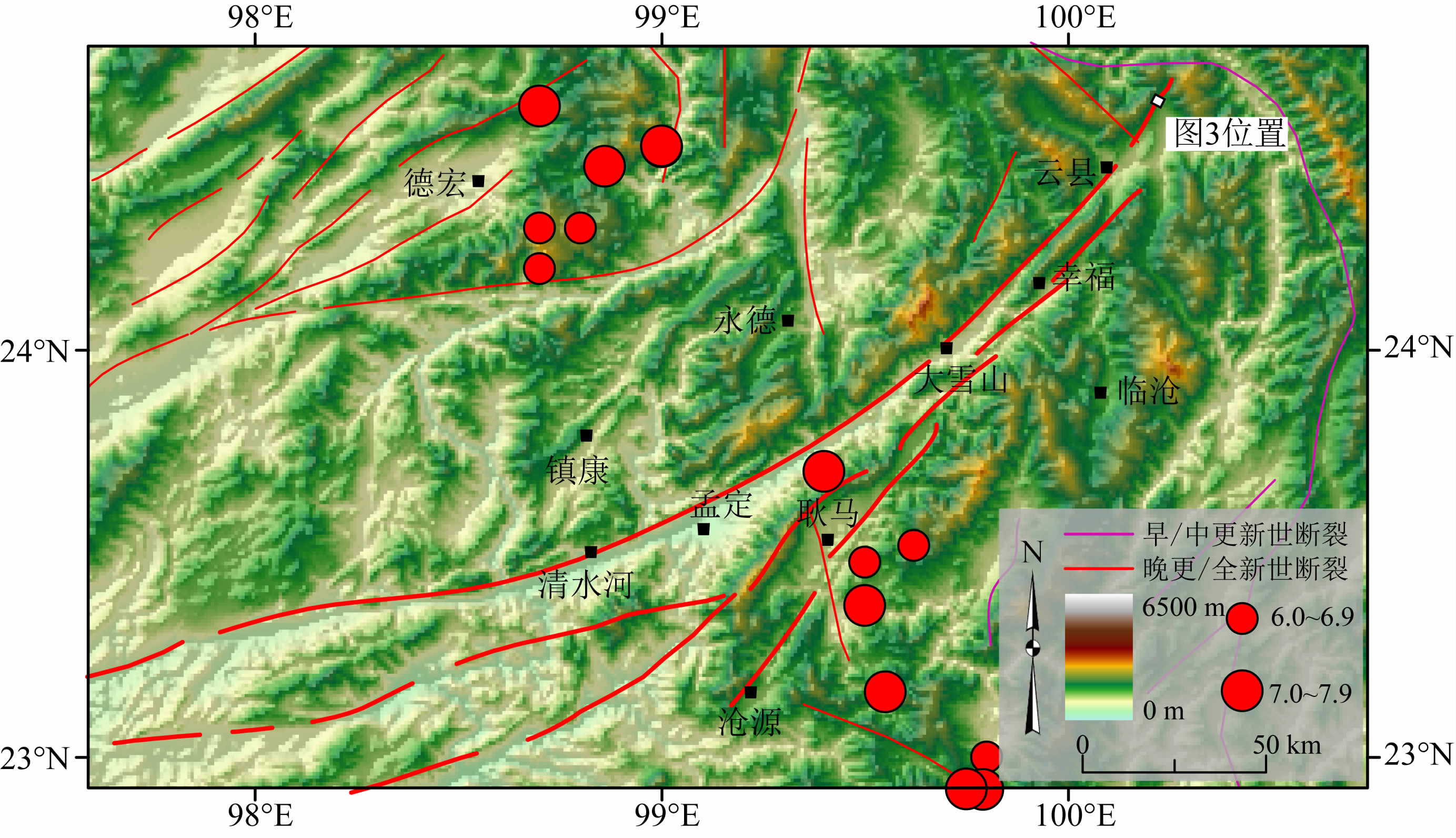 |
图 2 南汀河断裂带空间展布与周边地震活动 红色线段和紫色线段分别表示晚更新世活动断裂和早中更新世断裂(邓起东,2007),红色圆点表示历史地震(中国地震局,1995,1999)和仪器记录地震(中国地震台网中心,2015). Fig. 2 The Nantinghe fault zone and its surrounding seismicity Red lines represent late-Pleistocene and Holocene active faults,whereas purple lines indicate early- and mid-Pleistocene faults(Deng,2007). Red dots represent historical earthquakes(China Earthquake Administration,1995,1999) and instrumentally recorded earthquakes(China Earthquake Networks Center,2015). |
南汀河断裂带晚第四纪以来的运动方式是左旋走滑兼具一定的正断分量,水平滑动速率为约3.6±0.4 mm·a-1,垂直滑动速率为约1.1±0.3 mm·a-1(石峰,2014),与GPS观测结果(分别为约4.3±1.6 mm·a-1和1.2±1.5 mm·a-1)吻合较好(Shen et al.,2005; Wang et al.,2008).Wang等(2014)通过地貌解译获得滇西南块体内各断裂的总位错量,并估计这些断裂位错的起始时间为约5 Ma,据此得出大多数断裂的平均滑动速率都小于4 mm·a-1,而南汀河断裂则为4.2 mm·a-1,是块体内运动最快的断裂之一.
在断裂带北段最新的古地震研究结果显示,该断裂段在全新世以来曾发生过产生地表破裂的大地震,结合放射性碳测年结果,将该次地震活动的时间限定在900—1480 AD之间,显示了断裂带全新世强烈的地震活动性(图 3).Wells和Coppersmith(1994)统计断裂参数与震级经验关系的全球244个地震中,即使算上滑坡、裂缝等次生破裂,有地表形变的地震震级普遍都在6级以上.而在滇西南块体内,1988年发生在龙陵—澜沧断裂带上的澜沧7.6级地震和耿马7.2级地震,也只分别产生了约50 km和14 km的地表形变带(俞维贤等,1991).本次景谷6.6级地震除了地震动和重力作用影响在斜坡边缘形成了一些不具有构造意义的张性地裂缝外,并没有直接断错地表的破裂(石峰等,2014).因此,南汀河断裂带北段揭示的古地震的震级应该不低于7级.
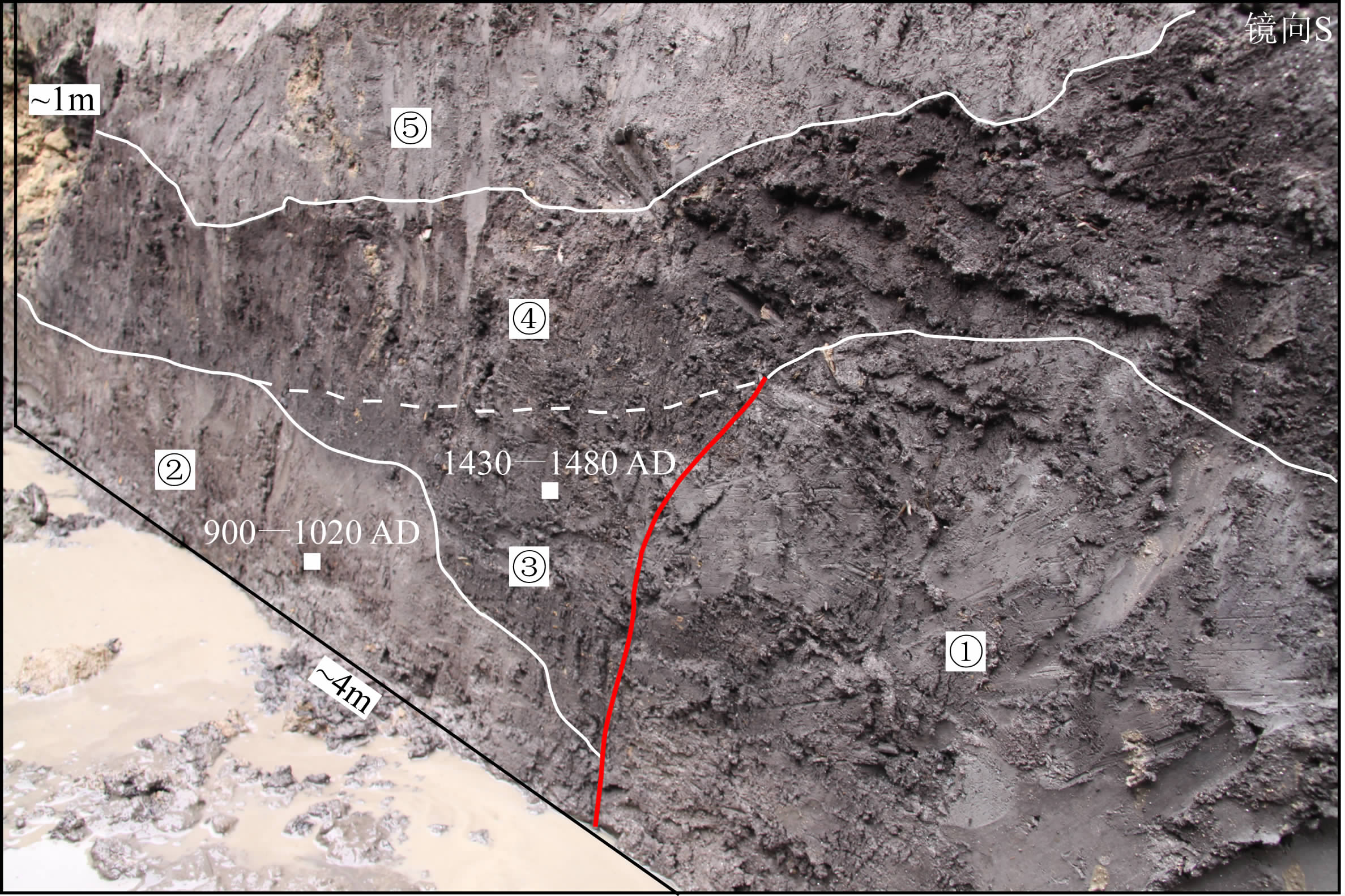 |
图 3 南汀河断裂带北段古地震探槽剖面 红色线段表示断层,白色线段代表地层界线:①灰色含有机质粘土层;②灰白色砂粘土层;③深灰色楔状含有机质粘土层;④深灰色含有机质粘土层;⑤灰白色砂粘土层.白色方块为放射性碳样品采集位置及校正后的测年结果(2σ),样品由美国Beta实验室测定. Fig. 3 Paleoseismological trench wall on the northern segment of the Nantinghe fault zone Red line shows the fault plane, while white lines indicate the stratigraphic boundaries between layers: ①grayish silt with organic materials, ②grayish white silt and silty-sand, ③wedge-shaped deposits of dark-gray silt with massive plant fracture, ④dark-gray silt with massive organic material, ⑤grayish white silt and silty-sand. White filled rectangles designate the location of radiocarbon samples labeled by their calibrated ages (2σ) dated by Beta Analytic Inc. (Miami, Florida, USA). |
此外,Wang等(2014)根据断裂总长度以及断裂长度-震级经验公式(Blaser et al.,2010; Wells and Coppersmith,1994),计算获得南汀河断裂带最大的发震能力为8.2级,远高于块体内的其他断裂带.但是与其较快的滑动速率形成鲜明对比的是,南汀河断裂带是块体内记录到地震活动较少的活动断裂带,仅西支断裂南段在1941年发生过一次约7级的地震,其余段落再无发生过5级以上地震的记录,处于上述的地震空区内(图 1),极有可能处于应力积累,孕育地震的过程中.
断层带上的应力状态除了受到板块运动引起的区域构造作用影响外,相邻区域的地震和火山等地质活动也可能引起断层带应力状态的变化,增加或减少应力的积累.所以,对于活动断裂来说,下一次地震的发生时间不仅取决于长期而缓慢的构造作用引起的应力积累,还受到邻区脉冲式的构造活动(如地震或火山喷发等)的扰动(如,Stein,1999; 江国焰,2013).景谷地震则是近年来发生在南汀河断裂带邻近区域内较大的一次地震事件,因此,查明该地震对南汀河断裂带上应力状态的扰动,对于了解和评价断裂带未来地震危险性具有重要的意义.
3 景谷地震同震静态库仑应力扰动本文基于Okada(1992)提出的弹性半无限空间模型,分别采用北京大学张勇等(2014)和中国科学院青藏高原研究所王卫民等(2014)提供的破裂模型,计算了景谷地震触发的在10 km深度的同震静态库仑应力变化(图 4).为了更好地分析静态库仑应力变化与余震分布之间的关系,我们还采用了King等(1994)的计算模型,将接收断层设为二维最优破裂面,同时将区域构造应力场的背景压应力设为104 kPa,并根据中国地震局地壳应力研究所崔效锋等给出的最大水平主应力的优势分布方位(http://www.eq-icd.cn/showinfo.asp?ArticleID=23949),将主应力方位角设为20°.考虑到此次地震的走滑运动特性,将摩擦系数设为0.3,拉梅系数设为3.2×1010 Pa(Parsons et al.,1999).
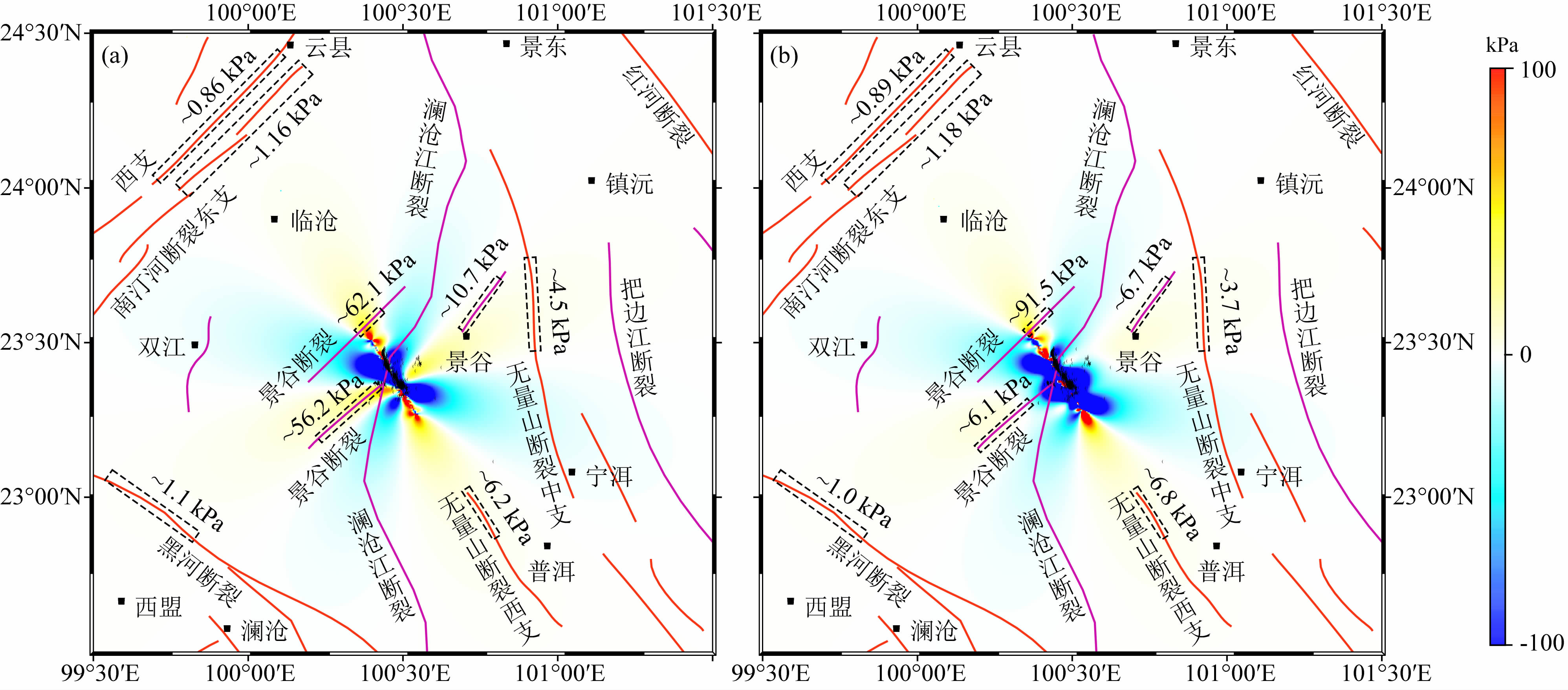 |
图 4
景谷地震触发的区域静态库仑应力分布(深度10 km):(a)基于张勇等(2014)破裂模型;(b)基于王卫民等(2014)破裂模型 颜色条中红色表示应力增加,蓝色表示应力减少;黑色虚线框及数值表示断层上应力增加区域和增加值. Fig. 4 Two kinds of static Coulomb stress changes triggered by the Jinggu earthquake from the coseismic slip models provided by Zhang et al.(2014)(a) and Wang et al.(2014)(b),respectively Red in color bar indicates positive change in static Coulomb stress, whereas blue indicates negative change. Black dashed rectangles show the fault segments where the changes are positive labeled by the values. |
总的来说,根据两种破裂模型计算的结果比较接近,应力增加和减小的区域都基本一致(图 4).南汀河断裂带的北段,龙陵—澜沧断裂带的黑河断裂中段,无量山断裂带北段,以及靠近震中的景谷断裂和澜沧江断裂都有部分段落位于应力增加区域(图 4,黑色虚线框).景谷地震对距离震中较近的景谷断裂和澜沧江断裂的影响最大,局部应力变化值可达90 kPa;而距离震中较远的断裂上的影响则相对小很多,其中南汀河断裂带北段和黑河断裂中段的静态库仑应力增加约1.1 kPa,无量山断裂带西支北段增加约6.8 kPa,中支北段增加约4.5 kPa(图 4).
景谷断裂和澜沧江断裂是早中更新世断裂(邓起东,2007),发震能力较弱,发生7级以上大地震的可能性较小;无量山断裂带自20世纪70年代至今多次发生6级以上地震,黑河断裂所处的龙陵—澜沧断裂带在1988年发生过两次7级以上的大地震和数次6级以上强余震,已经释放了大量的应力积累;而南汀河断裂带仅南段在1941年发生过一次7级地震,北段还没有5级以上地震的记录(图 1)(中国地震局,1995,1999;中国地震台网中心,2015).因此,在周边受到影响的断裂带中,尽管南汀河断裂带上的静态库仑应力增量最小,但并不意味着最安全.
为了进一步分析南汀河断裂带的地震危险性,获得断裂带上更精确的应力变化值,我们计算了南汀河断裂带北段断层面上的静态库仑应力扰动分布情况.根据南汀河断裂带左旋走滑兼具一定正断分量的运动性质和几何结构,设定断层面宽度为15 km,摩擦系数为0.3,断层面的倾角范围为70°至90°,滑动角范围取0°至-40°.结果如表 1所示,采用王卫民等(2014)的模型计算得到的静态库仑应力变化值整体略大于采用张勇等(2014)的模型获得的结果,但是差异并不显著.用同一滑动分布模型计算,固定断层倾角时,应力变化值随滑动角降低而降低;滑动角在0°至-20°时,应力变化值随断层倾角增大而增加;滑动角在-30°时,应力变化值几乎不变;当滑动角为-40°时,应力变化值反而随断层倾角的增大而降低.不同滑动分布模型的计算结果都显示,当断层倾角为90°,滑动角为0°时,南汀河断裂带北段上的静态库仑应力变化值最大,其中东支为1.18 kPa,西支为0.89 kPa(表 1).
| | 表 1 静态库仑应力计算接收断层参数及结果 Table 1 Parameters for the received fault during calculation of static Coulomb stress changes and results |
总体来说,两个模型计算结果显示,南汀河断裂带东西两支断裂断层面上触发的应力变化均呈半圆形分布,且沿深度向下逐渐减小,向北东和南西方向也逐渐减小(图 5).另外,在水平空间上应力增加的最大值位于24.15°N附近,采用王卫民等(2014)的模型计算获得的应力增加的最大值的位置比采用张勇等(2014)的模型的结果略微偏向南西.
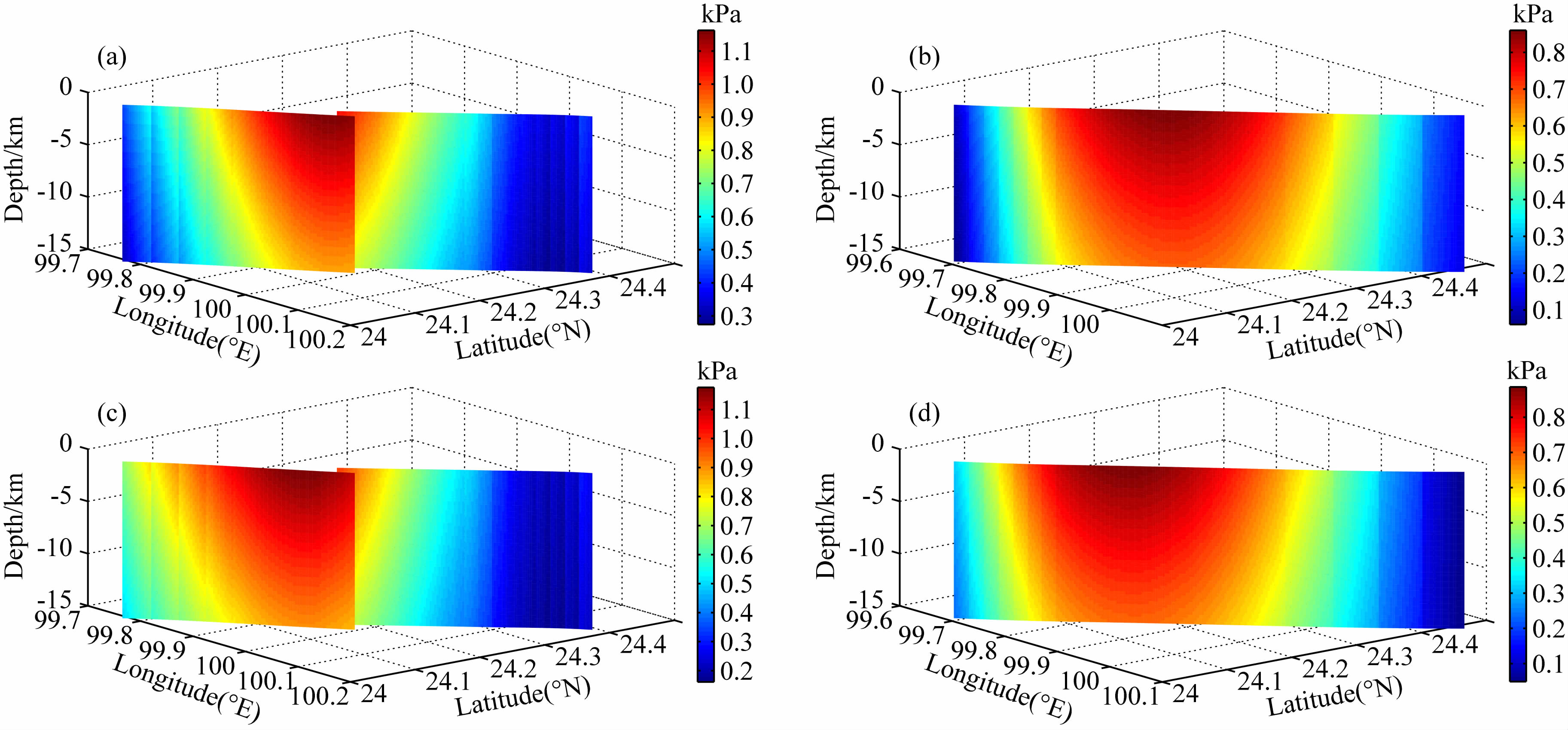 |
图 5 景谷地震触发南汀河断裂带北段断层面上静态库仑应力扰动分布图 接收断层倾角为90°,滑动角为0°.(a)和(b)分别为基于张勇等(2014)滑动分布模型的东支断裂和西支断裂;(c)和(d)分别为基于王卫民等(2014)滑动分布模型的东支断裂和西支断裂. Fig. 5 Distribution of the static Coulomb stress perturbation on the Nantinghe fault zone triggered by the Jinggu earthquake The dip angle of the received fault is 90° and the rake angle is 0°.(a)&(b)East and west branches based on the slip distribution model by Zhang et al.(2014).(c)&(d)East and west branches based on the slip distribution model by Wang et al.(2014). |
应力触发是指地震和火山等地质活动发生后在周边区域和邻近断层上引起的库仑破裂应力变化.若变化量为正,有可能触发后续的地震,增加地震危险性;反之则会降低地震危险性.在分析库仑应力扰动对地震活动影响时,通常认为10 kPa为起显著触发作用的最低阈值(Stein,1999).上面的计算结果显示景谷地震对南汀河断裂带、龙陵—澜沧断裂带和无量山断裂带造成的应力增加量均小于10 kPa,暗示景谷地震不会引起这些断裂的地震活动性发生突变.然而南汀河断裂带北段最新一次地震发生在900—1480 AD之间,离逝时间为535—1115年,结合断裂带3.6±0.4 mm·a-1的水平滑动速率(石峰,2014),利用蒙托卡罗方法(Amos et al.,2007,2010; Thompson et al.,2012; Li et al.,2013)计算出该断裂段目前已经积累的水平滑动量为2.8+1.5/-1.0 m.进一步利用Wells和Coppersmith(1994)统计获得的走滑断裂平均滑动量与震级的经验公式,可估算出南汀河断裂带北段目前积累的水平滑动量如果完全释放将会产生一个7.5+0.1/-0.2级的地震.虽然景谷地震对南汀河断裂带地震活动的影响较小,不足以诱发破坏性地震,但是仍然起到了一定的加速作用.再考虑到断裂带北段目前已经积累了约7.5级地震所需的能量,该断裂段在未来具有较高的地震危险性.
4 结论南汀河断裂带是一条全新世活动断裂,在其北段进行的古地震研究表明,断裂带全新世以来发生过产生地表破裂的大地震,放射性碳测年结果将该次地震事件发生的时间限定在约900—1480 AD之间.景谷地震是滇西南块体内部的一次中等强度的地震,对周边断裂造成了一定的静态库仑应力扰动,其中震中附近的断裂上的应力变化量最大可达90 kPa,而距震中较远的断裂上的应力变化量则都在10 kPa以下.进一步分析该地震对南汀河断裂带北段的影响发现,断层面上的静态库仑应力扰动呈半圆形分布,应力增加的最大值在24.15°N附近的地表,并沿断层面的走向和深度逐渐减小.其中西支的应力增加最大值为0.89 kPa,东支为1.18 kPa,虽然小于显著影响断裂的应力状态和地震活动的最低阈值,不会引起地震危险性的突变,但是存在一定的加速作用.再考虑到南汀河断裂带北段目前已经积累了约7.5级地震的能量,该断裂段在未来具有较高的地震危险性.
致谢 本文采用的景谷地震余震重定位数据由中国地震局地球物理研究所房立华副研究员提供,景谷地震同震滑动分布模型由北京大学张勇研究员和中国科学院青藏高原研究所王卫民副研究员提供,景谷地震区域构造应力场图由中国地震局地壳应力研究所崔效锋研究员提供,审稿人的意见对文章的改进起到了很大的帮助,在此一并致谢.| [1] | Amos C B, Burbank D W, Nobes D C, et al. 2007. Geomorphic constraints on listric thrust faulting: Implications for active deformation in the Mackenzie Basin, South Island, New Zealand. Journal of Geophysical Research: Solid Earth (1978-2012), 112: B03S11, doi: 10.1029/2006JB004291. |
| [2] | Amos C B, Burbank D W, Read S A L. 2010. Along-strike growth of the Ostler fault, New Zealand: Consequences for drainage deflection above active thrusts. Tectonics, 29(4): TC4021, doi: 10.1029/2009TC002613. |
| [3] | Blaser L, Krüger F, Ohrnberger M, et al. 2010. Scaling relations of earthquake source parameter estimates with special focus on subduction environment. Bulletin of the Seismological Society of America, 100(6): 2914-2926, doi: 10.1785/0120100111. |
| [4] | China Earthquake Administration. 1995. Historical Strong Earthquake Catalog of China (2300 BC-1911 AD) (in Chinese). Beijing: Seismological Press. |
| [5] | China Earthquake Administration. 1999. Recent Earthquake Catalog of China (1912-1990 AD, MS≥4.7) (in Chinese). Beijing: Chinese Science and Technology Press. |
| [6] | China Earthquake Networks Center. 2015. Seismological data service system (in Chinese). http://www.csndmc.ac.cn/newweb/data.htm (last accessed October 2015). |
| [7] | Deng Q D. 2007. Map of Active Tectonics in China (in Chinese). Beijing: Seismological Press. |
| [8] | Deng Q D, Cheng S P, Ma J, et al. 2014. Seismic activities and earthquake potential in the Tibetan Plateau. Chinese Journal of Geophysics (in Chinese), 57(7): 2025-2042, doi: 10.6038/cjg20140701. |
| [9] | Guo S M, Xiang H F, Xu X W, et al. 2000. Characteristics and formation mechanism of the Longling-Lancang newly emerging fault zone in Quaternary in the southwest Yunnan. Seismology and Geology (in Chinese), 22(3): 277-284. |
| [10] | Guo S M, Xiang H F, Zhou R Q, et al. 2000. Longling-Lancang fault zone in southwest Yunnan, China——A newly-generated rupture zone in continental crust. Chinese Science Bulletin, 45(4): 376-379, doi: 10.1007/BF02909774. |
| [11] | Jiang G Y. 2013. Assessing the seismic hazards of active faults using Coulomb failure criterion [Ph. D. thesis] (in Chinese). Wuhan: Wuhan University. |
| [12] | King G C P, Stein R S, Lin J. 1994. Static stress changes and the triggering of earthquakes. Bulletin of the Seismological Society of America, 84(3): 935-953. |
| [13] | Lacassin R, Replumaz A, Leloup P H. 1998. Hairpin river loops and slip-sense inversion on southeast Asian strike-slip faults. Geology, 26(8): 703-706, doi: 10.1130/0091-7613(1998)026〈0703:HRLASS〉2.3.CO;2. |
| [14] | Li T, Chen J, Thompson J A, et al. 2013. Quantification of three-dimensional folding using fluvial terraces: A case study from the Mushi anticline, northern margin of the Chinese Pamir. Journal of Geophysical Research: Solid Earth, 118(8): 4628-4647, doi: 10.1002/jgrb.50316. |
| [15] | Okada Y. 1992. Internal deformation due to shear and tensile faults in a half-space. Bulletin of the Seismological Society of America, 82(2): 1018-1040. |
| [16] | Parsons T, Stein R S, Simpson R W, et al. 1999. Stress sensitivity of fault seismicity: A comparison between limited-offset oblique and major strike-slip faults. Journal of Geophysical Research: Solid Earth (1978-2012), 104(B9): 20183-20202, doi: 10.1029/1999JB900056. |
| [17] | Shen Z K, LÜ J N, Wang M, et al. 2005. Contemporary crustal deformation around the southeast borderland of the Tibetan Plateau. Journal of Geophysical Research: Solid Earth (1978-2012), 110(B11): B11409, doi: 10.1029/2004JB003421. |
| [18] | Shi F. 2014. Tectonic geomorphology of the Nantinghe Fault in southwest Yunnan [Ph. D. thesis] (in Chinese). Beijing: Institute of Geology, China Earthquake Administration. |
| [19] | Shi F, He H L, Yuan R M, et al. 2014. Genetic analysis of ground fissures around epicenter of 2014 Jinggu earthquake, Yunnan Province. Technology for Earthquake Disaster Prevention (in Chinese), 9(4): 782-789, doi: 10.11899/zzfy20140405. |
| [20] | Stein R S. 1999. The role of stress transfer in earthquake occurrence. Nature, 402(6762): 605-609, doi: 10.1038/45144. |
| [21] | Thompson S C, Weldon R J, Rubin C M, et al. 2002. Late Quaternary slip rates across the central Tien Shan, Kyrgyzstan, central Asia. Journal of Geophysical Research: Solid Earth (1978-2012), 107(B9): 2203, doi: 10.1029/2001JB000596. |
| [22] | Wang E, Burchfiel B C. 1997. Interpretation of Cenozoic tectonics in the right-lateral accommodation zone between the Ailao Shan shear zone and the eastern Himalayan syntaxis. International Geology Review, 39(3): 191-219, doi: 10.1080/00206819709465267. |
| [23] | Wang E, Burchfiel B C, Royden L H, et al. 1998. Late Cenozoic Xianshuihe-Xiaojiang, Red River, and Dali fault systems of southwestern Sichuan and central Yunnan, China. Geological Society of America Special Papers, 327: 1-108, doi: 10.1130/0-8137-2327-2.1. |
| [24] | Wang J N, Wang Y L, An X W, et al. 2006. Analysis of latest activity on NE-segment of west branch of Nantinghe Fault. Journal of Seismological Research (in Chinese), 29(3): 264-268. |
| [25] | Wang W M, Hao J L, Yao Z X. 2014. Preliminary result for Rupture Process of Oct.7, 2014, MS6.6 Earthquake, Jinggu, Yunnan, China (in Chinese). http://www.lcpu.itpcas.ac.cn/ReadArt.aspx?id=485. |
| [26] | Wang Y, Sieh K, Tun S T, et al. 2014. Active tectonics and earthquake potential of the Myanmar region. Journal of Geophysical Research: Solid Earth, 119(4): 3767-3822, doi: 10.1002/201 3JB010762. |
| [27] | Wang Y Z, Wang E N, Shen Z K, et al. 2008. GPS-constrained inversion of present-day slip rates along major faults of the Sichuan-Yunnan region, China. Science in China Series D: Earth Sciences, 51(9): 1267-1283, doi: 10.1007/s11430-008-0106-4. |
| [28] | Wells D L, Coppersmith K J. 1994. New empirical relationships among magnitude, rupture length, rupture width, rupture area, and surface displacement. Bulletin of the Seismological Society of America, 84(4): 974-1002. |
| [29] | Xu X W, Wen X Z, Zheng R Z, et al. 2003. Pattern of latest tectonic motion and its dynamics for active blocks in Sichuan-Yunnan region, China. Science in China Series D: Earth Sciences, 46(Suppl. 2): 210-226, doi: 10.1360/03dz0017. |
| [30] | Yeats R S, Sieh K, Allen C R. 1997. The Geology of Earthquakes. New York: Oxford University Press. |
| [31] | Yu W X, Hou X Y, Zhou R Q, et al. 1991. Characteristic surface ruptures of Lancang-Gengma Earthquake. Journal of Seismological Research (in Chinese), 14(3): 203-214. |
| [32] | Zhang P Z, Deng Q D, Zhang G M, et al. 2003. Active tectonic blocks and strong earthquakes in the continent of China. Science in China Series D: Earth Sciences, 46(Suppl. 2): 13-24, doi: 10.1360/03dz0002. |
| [33] | Zhang Y, Xu L S, Chen Y T. 2014. Rupture process of Oct.7, 2014, Jinggu MS6.6 Earthquake, Yunnan Province (in Chinese). . |
| [34] | Zhu Y X, Li P, Ren J W. 1994. Activity of Nandinghe Fault Zone and its paleoearthquake events. Earthquake Research in China (in Chinese), 10(4): 347-356. |
| [35] | 邓起东. 2007. 中国活动构造图. 北京: 地震出版社. |
| [36] | 邓起东, 程绍平, 马冀等. 2014. 青藏高原地震活动特征及当前地震活动形势. 地球物理学报, 57(7): 2025-2042, doi: 10.6038/cjg20140701. |
| [37] | 虢顺民, 向宏发, 徐锡伟等. 2000. 滇西南龙陵—澜沧第四纪新生断裂带特征和形成机制研究. 地震地质, 22(3): 277-284. |
| [38] | 江国焰. 2013. 利用库仑破裂准则评估活动断层地震危险性[博士论文]. 武汉: 武汉大学. |
| [39] | 石峰. 2014. 南汀河断裂带构造地貌研究[博士论文]. 北京: 中国地震局地质研究所. |
| [40] | 石峰, 何宏林, 袁仁茂等. 2014. 2014年景谷地震震中附近地裂缝成因初析. 震灾防御技术, 9(4): 782-789, doi: 10.11899/zzfy20140405. |
| [41] | 王晋南, 王洋龙, 安晓文等. 2006. 南汀河西支断裂北东段最新活动性分析. 地震研究, 29(3): 264-268. |
| [42] | 王卫民, 郝金来, 姚振兴. 2014. 2014年10月7日云南景谷MS6.6级地震震源破裂过程反演初步结果. http://www.lcpu.itpcas.ac.cn/ReadArt.aspx?id=485. |
| [43] | 俞维贤, 侯雪英, 周瑞琦等. 1991. 澜沧—耿马地震的地表破裂特征. 地震研究, 14(3): 203-214. |
| [44] | 张勇, 许力生, 陈运泰. 2014. 2014年10月7日云南省普洱市景谷傣族彝族自治县 MS6.6地震破裂过程. http://www.cea-igp.ac.cn/upload/Image/mrtp/2709093959.jpg |
| [45] | 中国地震局. 1995. 中国历史强震目录(公元前23世纪—公元1911年). 北京: 地震出版社. |
| [46] | 中国地震局. 1999. 中国近代地震目录(公元1912年—1990年MS≥4.7). 北京: 中国科学技术出版社. |
| [47] | 中国地震台网中心. 2015. 地震数据管理与服务系统. http://www.csndmc.ac.cn/newweb/data.htm. |
| [48] | 朱玉新, 李玶, 任金卫. 1994. 南定河断裂带断层活动特征与古地震事件. 中国地震, 10(4): 347-356. |
 2015, Vol. 58


