2. 中国科学院遥感与数字地球研究所, 北京 100094;
3. 中国科学院大学, 北京 100049;
4. 中国地震局地震预测研究所, 北京 100036
2. Key Laboratory of Digital Earth Sciences, Institute of Remote Sensing and Digital Earth, Chinese Academy of Sciences, Beijing 100094, China;
3. University of Chinese Academy of Sciences, Beijing 100049, China;
4. Institute of Earthquake Science, China Earthquake Administration, Beijing 100036, China
The method of tectonic geomorphology was used to analyze fault activity. By measuring the deformation of the typical geomorphic or geologic units together with dating data, fault activity was estimated. The measurement was finished indoor or in the field. Remote sensing data were interpreted and geologic maps were prepared. According to the interpretation of drainage systems based on the remote sensing data, displacement of faults were determined. In the field, the rope and scale were employed for measurement (if displacement is too long, GPS equipment was used). Using dating technology, motion rates on the faults in the study area were estimated.
The analysis of tectonic geomorphology along the Nanting fault zone, and drainages and channels across the fault zone shows systematically left-lateral offset. The largest offset occurs along the Nujiang River, and total displacement of the fault here is about 10 km. Moreover, offsets of rivers near the village Datianba range from 1.5 to 5.5 km and 1.8 to 2.1 km near Panhe Farm, respectively. Besides geomorphic units, geologic units are also displaced. Granite bodies west of the Yun County show obviously sinistral slip ranging from 4.1m to 5.6 km.
Based on the tectonic characteristics and deep dynamic mechanism of NE-trending tectonics within the Yunnan-Myanmar block, the following conclusions are obtained. Firstly, the maximum displacement of the NE-trending left lateral strike-slip fault zone is 10 km. According to its initial age of 5 Ma, the minimum of the left lateral strike slip rate is ca. 2 mm·a-1. Secondly, the late Cenozoic tectonic deformation and seismic activity of the Yunnan-Myanmar block are mainly controlled by the East India plate subduction, and the deformation in dominated by strike slip on faults. Thirdly, based on the analysis of the scales of NE direction left-lateral faults and recurrence times of historical earthquakes, the study region including the Nantinghe, Wanding and Dayingjiang fault zones and the surrounding areas has risk of large earthquakes of magnitude 7 or greater. More attention should be paid to earthquake prevention and risk assessment of large engineering projects in this region.
滇缅地块位于青藏高原东南缘,东与川滇菱形块体相接,西北与喜马拉雅东构造结相邻,是我国大陆构造活动强烈的地区之一(Fu et al.,2011)(图 1).由于受到来自印度板块的东向俯冲以及青藏高原的侧向挤出双重作用(Li et al.,2008; Lei et al.,2009; Chen et al.,2013),形成以红河、实皆为主要控制性边界、与其他一系列NE和NW向的复活或新生断裂带相配套、以大规模水平走滑运动为主要特征的构造格局(Molnar and Tapponnier,1975;Tapponnier et al.,1982,1986;许志琴等,2011)(图 1).区内构造活动强烈,大震频发.自1900年以来,发生MS7.0以上大震超过10次,占据整个云南地区大震半数以上(皇甫岗等,2000; 皇甫岗和秦嘉政,2006).自1976年龙陵地震,大震发生频率更有一种增加趋势(皇甫岗等,2000; 苏有锦和秦嘉政,2001;皇甫岗和秦嘉政,2006).除1988年澜沧地震外,其余都发生在NE向走滑断裂带上或附近(陈立德等,1979;俞维贤等,1991;姜葵,1993;虢顺民等,2000;皇甫岗等,2014;Wang et al.,2014).作为滇缅地块内部重要的NE向构造—南汀河断裂带一直备受关注(董兴权等,1982,1984;姜葵,1993;朱玉新等,1994;Wang and Burchfiel,1997;向宏发等,1999;毛玉平,2003;王晋南等,2006;Wang et al.,2014).在此断裂带北东段曾经发生MS7.0地震(1941年5月16日),同时,沿该断裂带还发现多次MS7.0以上地震(古地震)记录(董兴权等,1984;朱玉新等,1994).2015年3月1日沧源MS5.5地震是该断裂带最新一次中强震活动.根据中国地震台网测定:这次地震发生在云南省临沧市沧源佤族自治县(北纬23.5°,东经98.9°),震源深度11 km.
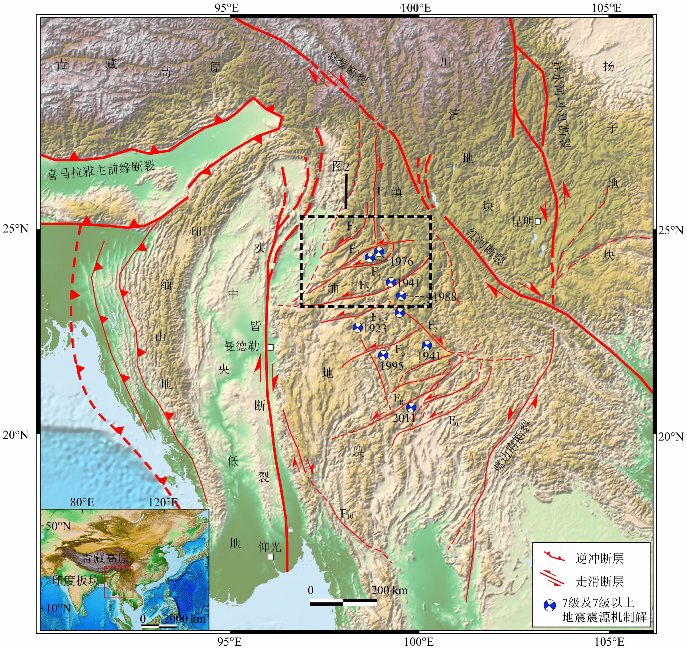 |
图 1 青藏高原东南缘滇缅地块及其周边地区地震及活动构造 F1:怒江断裂; F2:大盈江断裂; F3:龙陵—瑞丽断裂; F4:畹町断裂; F5:南汀河断裂; F6:孟连断裂; F7:澜沧江断裂; F8:蒙帕亚—勐腊断裂; F9:梅江断裂; F10:王朝断裂. Fig. 1 Active tectonic map showing major tectonic units and focal mechanisms of modern major earthquakes in the Yunnan-Myanmar block and adjacent regions, southeastern margin of Tibetan plateau F1:Nujiang Fault; F2:Dayingjiang Fault; F3:Longling-Ruili Fault; F4:Wanding Fault; F5:Nanting Fault; F6:Menglian Fault; F7:Lancangjiang Fault; F8:Meng Paya-Mengla Fault; F9:Meijiang Fault; F10:Wang Chao Fault. |
20世纪20年代以来,滇缅地块内部已连续发生了10多次MS7.0以上地震(图 1).最近一次大地震是2011年发生在缅甸蒙帕亚—勐腊断裂的孟帕亚MS7.2大地震.除此之外,滇缅地块内部未发生过其他MS7.0以上大震.按照皇甫岗等(2000)以及皇甫岗和秦嘉政(2006)对云南地震活动的分期,将两次大震的间隔时间看作一个地震平静期,则2011年孟帕亚地震可能是新一轮地震活跃期的序幕(皇甫岗等,2014).若以一个地震活跃期内可能发生3~4次MS7.0以上地震计,未来在滇西地块内部还可能有2~3次MS7.0以上地震.那么,这些地震将会发生在什么地方?震级有多大?尤其此次沧源MS5.5地震,是一次独立地震事件,还是大地震的前震,非常值得关注的.因此,出于防震减灾需要,在区域内开展地震危险性评价工作显得非常必要和紧迫,特别像南汀河这样的NE向大型走滑断裂带.
本研究借助卫星遥感影像和数字高程模型(DEM)数据,通过对研究区NE向断裂带空间几何学展布以及晚新生代构造地貌特征详细分析,并结合野外地貌调查及区内地震活动特征,对南汀河断裂带及周边地区的地震活动性及大地震危险性进行预测.
2 地质背景研究区位于滇缅地块的中北部,夹于红河与实皆两大右旋走滑断裂系之间(图 1).区内自北向南分布数条NE向断裂带,主要包括大盈江、龙陵—瑞丽、畹町和南汀河等断裂带(图 1).大盈江断裂可分为中国云南境内的NE段和缅甸境内的SW段,全长170 km.NE段为梁河盆地西北缘、盈江盆地东南缘的边界断裂,对梁河盆地、盈江盆地有明显控制作用(常祖峰等,2011).虢顺民等(1999)认为大盈江断裂NE段属晚更新世—全新世活动断裂,以左旋走滑为主,兼有正断层分量.断裂SW段由于分布于缅甸境内,研究成果较少,少量的结果表明其属晚更新世活动断裂,以左旋走滑为主(安晓文等,2009).龙陵—瑞丽断裂带因1976龙陵地震受到关注(陈立德等,1979;黄学猛等,2010;贺根文等,2014).断裂带西起瑞丽盆地,向东经遮放、芒市、镇安、施甸南至昌宁以东,全长超过200 km,是区内相对较大的断裂带.近期研究表明该断裂属晚更新世活动断裂,全新世活动较弱(贺根文等,2014).畹町断裂带以瑞丽盆地为界,分为东西两支.东支沿瑞丽盆地东北向东经畹町、曼海、中山、安定、高家寨、蚌东、旧城、新寨,至于昌宁县湾甸境内,呈向南突出的弧形展布,蚌冬以西走向近EW,以东走向NE,倾向N和NW,倾角60°~80°,全长170 km(常祖峰等,2012;吴中海等,2012).断裂西支沿瑞丽盆地南边界向西延入缅甸境内,走向EW,全长70~80 km.此外,区内跨畹町断裂带的一级水系呈明显左旋弯曲,左旋位移量近10~12 km(Lacassin et al.,1998; 吴中海等,2012).
作为沧源MS5.5地震的发震构造—南汀河断裂带是区内规模最长的NE走向走滑断裂带(朱玉新等,1994;Wang et al.,2014).断裂带在遥感影像中,线性影像特征十分清楚,分南北两支,并在云县盆地交汇(图 2).断裂带南支自云县盆地向西南经幸福、勐永、勐撒、耿马盆地,再往南线性特征已不太清楚,整体走向30°N—40°E;断裂带北支自云县盆地沿南桥河向西南,经勐底、勐旨,顺南定河过热水塘、勐简西北,经勐定清水河出境延入缅甸,并可能与实皆断裂相连(Wang and Burchfiel,1997).断裂带全长近400 km,整体走向30°N—60°E(图 2).
 | 图 2 南汀河断裂带及其周边主要NE向断裂带的空间展布特征(21世纪以来5级以上中强地震的震源机制解表明这些断裂带活动以走滑为主) Fig. 2 Spatial extension of the Nanting River fault zone and other major NE-striking fault zones (Focal mechanisms of modern strong earthquakes in this region show the strike-slip motion of the active faults) |
从地貌特征看,断裂带西支穿过缅甸境内的Mogok变质带,形成明显的左行扭曲(Socquet and Pubellier,2005; Wang et al.,2014).此外,一些大型河流,如怒江(境外称萨尔温江)在穿过断裂带时也发生左旋错断(图 2)(Lacassin et al.,1998; Wang et al.,2014).与此同时,一系列冲沟与冲洪积扇也发生系统性位错,例如云县盆地附近的水系及冲积扇被左旋错断50~150 m(Wang and Burchfiel,1997).
断裂带南北两支第四纪活动性差异较大(朱玉新等,1994).沿断裂带南支,地形反差不大,盆地和山体之间界限不是很明显;而北支断裂构造清晰,结构相对成熟(Wang et al.,2014).因此,这意味着北支断裂第四纪活动性要可能强于南支.沿断裂带南支较少发育第四纪盆地(除幸福和勐永盆地有少量第四系沉积,其余均为第三纪盆地)也足以证明这一点(朱玉新等,1994).断裂带北支也是1941年耿马MS7.0地震的发震断层(Wang and Burchfiel,1997).需要指出的是,关于1988年发生在断裂带附近的耿马MS7.6地震发震断层也一直存在争议(Holt et al.,1991;朱玉新等,1994;虢顺民等,2000;王晋南等,2006),因此需要进一步的工作对其确认.
3 NE走向左旋走滑断裂带的构造地貌特征沿NE向走滑断裂带,左旋走滑构造地貌特征发育.以南汀河断裂带为例,横跨断裂带的不同级别的水系、冲沟表现出系统的左旋拐弯,地质体亦表现出明显的左旋错断特征.本研究利用30 m精度的ASTER DEM数据和1:20万地质图对沿断裂带发育的水系地貌和地质体错位特征进行提取.下面对这些构造地貌特征进行详细介绍.
3.1 水系拐弯利用沿断裂带发育的构造地貌特征研究断裂的活动性的方法已相当成熟(Fu et al.,2005; 付碧宏等,2006;Fu and Awata,2007; 贺根文等,2014).在南汀河断裂带北支的西南段,怒江(缅甸称萨尔温江)穿过断裂带时,发生近10 km的左旋拐弯(图 3).Wang和Burchfiel(1997)和Lacassin等(1998)认为怒江在此处左旋弯曲大于8 km.Wang等(2014)在怒江现今河道东侧发现被遗弃的古河道,因此认为怒江被左旋错断15 km左右(图 3).沿断裂带向东,位于勐定与勐简盆地之间的南棒河,其左旋位错也近6 km(图 3).
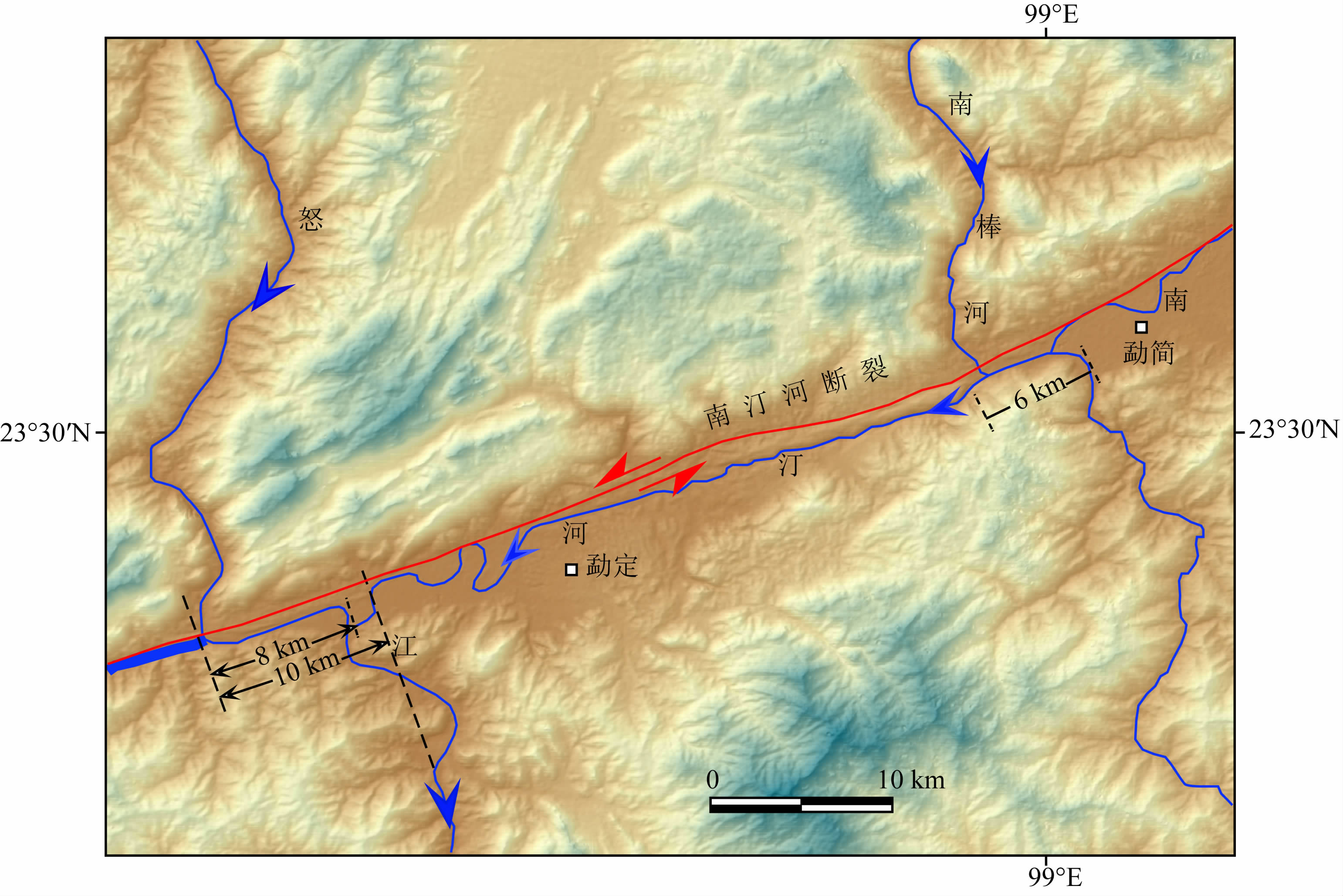 | 图 3 沿南汀河断裂带怒江及南棒河表现出系统的左旋拐弯地貌特征 Fig. 3 Systematic left-lateral offsets of the Nujiang and Nanbang river along the Nanting River fault |
通过对大田坝附近的横跨南汀河断裂带一系列冲沟水系解译发现,小水系表现出系统的左旋弯曲,水系位错距离1.5~5.5 km(图 4).同样在大田坝以东盘河农场附近,水系左旋拐弯位错在1.8~2.1 km(Wang et al.,2014).此外,Wang和Burchfiel(1997)对云县盆地内更小级别冲沟系统拐弯进行统计,发现其左旋位错距离在50~150 m之间.
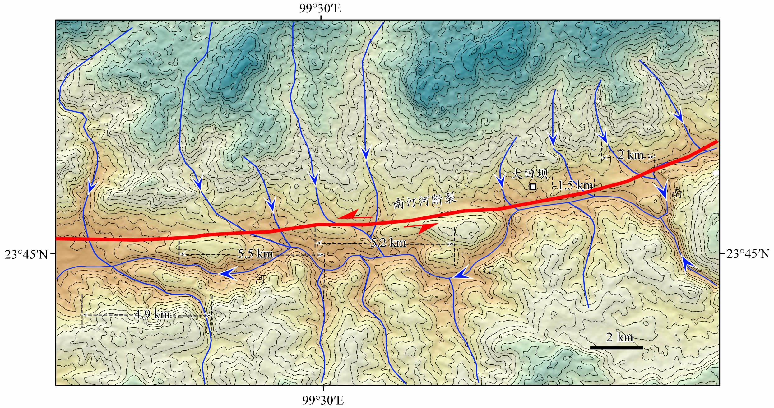 | 图 4 南汀河断裂带中段大田坝附近小型水系系统错位特征 Fig. 4 Systematic left-lateral offsets of the drainage system along the middle Nanting River fault |
云县西南燕山期黑云母花岗岩被南汀河断裂错断,且岩体东西两侧位错并不一致,其北东部分左旋错断距离为5.6 km,南西部分左旋位错4.1 km(图 5).断裂发育于花岗岩或花岗岩与变质岩分界处,近断面岩石破碎成白色粉末,碎裂岩松散且发育断层泥.野外考察发现,花岗岩上覆T3阶地洪积物并未断开(王晋南等,2006).通过对采得的断层泥样做电子自旋共振(ESR)定年,获得断层最新活动年龄为861±73 ka(王晋年等,2006).
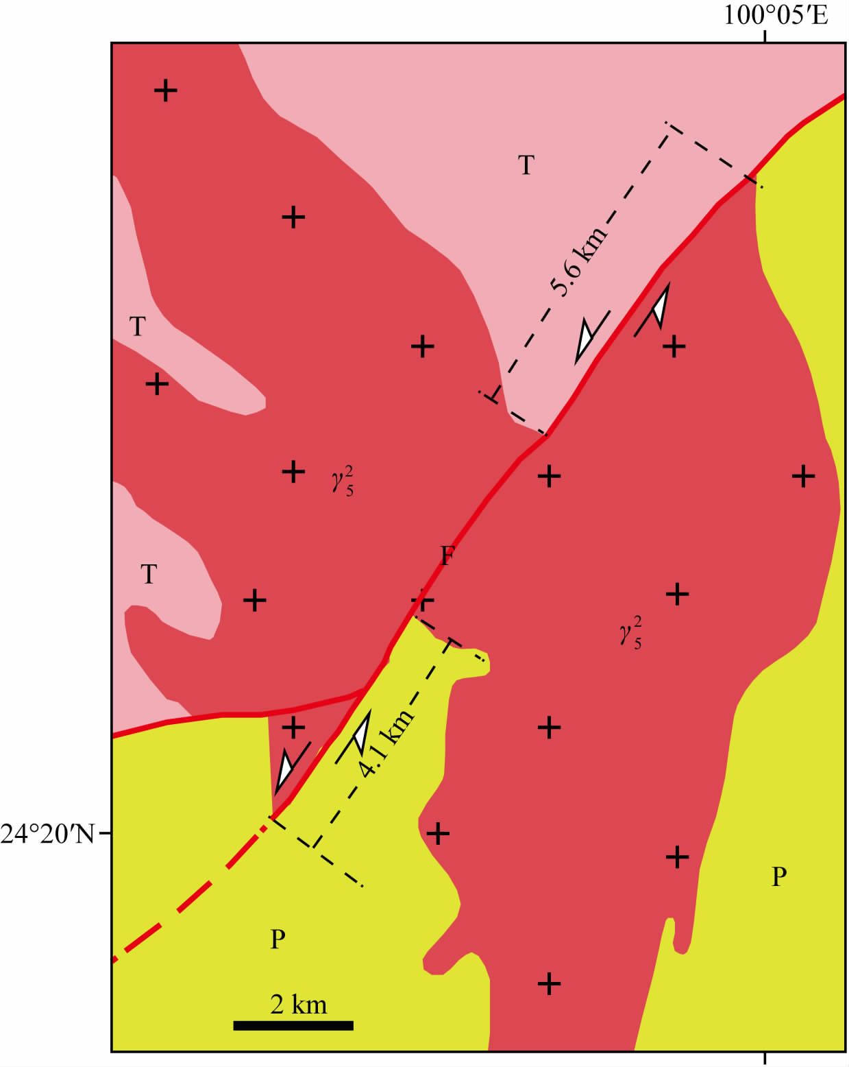 | 图 5 南汀河断裂带北东段云县西南一带花岗岩地质体的左旋错位特征 Fig. 5 Left-lateral offsets of the granite bodies along the Nanting River fault |
关于南汀河断裂带最大左旋走滑位移量有着不同的观点(Wang and Burchfiel,1997; Wang et al.,1998;Wang et al.,2014).Wang和Burchfiel(1997)根据断裂带中部蛇纹岩缝合带位错,分析其总的左旋走滑位移量40~50 km.Wang等(2014)通过提取断裂带附近水系几何学特征,估算断裂带最大左旋走滑距离约为21 km,这一结果主要依据对云县附近的澜沧江支流—南桥河水系位错解译(图 6).此外,Wang和Burchfiel(1997)估算幸福盆地附近南汀河拐弯长度17 km.根据对30 m分辨率的ASTER-DEM影像解译,南桥河拐弯长度约为38 km,南汀河在幸福盆地附近拐弯长度约为24 km.前人研究认为这些水系拐弯现象代表南汀河断裂带晚新生代最大左旋走滑错位(Wang and Burchifel,1997;Wang et al.,2014).实际上,这些水系是沿断裂带分布的区域一级水系(澜沧江)的支流,属于区域的二级或三级水系,其目前表现出的几何学特征是由于这些水系在断裂作用下发生重组的结果,它们不能代表南汀河断裂带晚新生代以来左旋走滑活动的最大累积位移量.云县附近4.1~5.6 km花岗岩地质体的左旋位错,表明根据二级水系估算出的21 km左旋走滑位移量明显偏大,也更不可能是38 km.而40~50 km的岩体位移量估算值,由于缺少大比例尺的精确构造解译,也不能完全令人信服(从“Wang和Burchfiel,1997”文中小比例尺的解译图看,错断距离没有40~50 km).沿走滑断裂,水系发生系统性拐弯,水系越大,其拐弯距离越长(Fu et al.,2005; Fu and Awata,2007; 付碧宏等,2009).因此,勐定盆地以西的区内一级水系—怒江10 km的左旋拐弯可以代表南汀河断裂带的晚新生代最大左旋位错量的下限,而东侧南棒河作为区域内二级水系,由于其形成年代相对较晚,其6 km的左旋拐弯只能代表二级水系形成后断裂带左旋走滑的位移量(图 3).另外,南汀河断裂带以北的畹町断裂带地貌错位特征研究表明,怒江跨此断裂带形成的左旋位错也在10~12 km左右(常祖峰等,2012).因此,将10 km左右的走滑量作为南汀河断裂的最大左旋走滑位移量的下限可能比较合理.
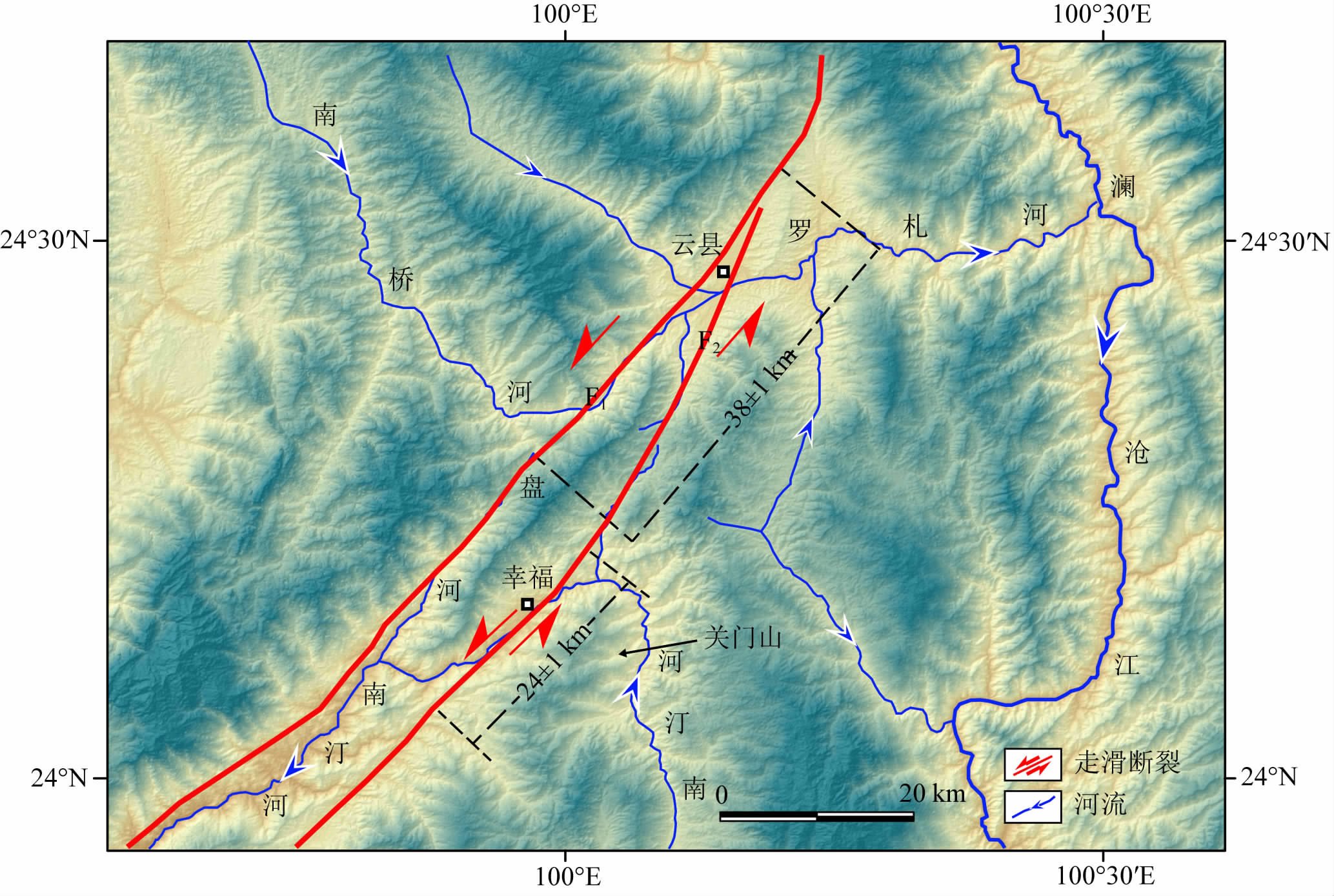 | 图 6 南汀河断裂带在云县附近发育的水系方式与地貌特征 Fig. 6 Pattern of the drainage system developed along the Nanting River fault near Yunxian county |
若以5 Ma作为南汀河断裂带起始左旋走滑的年龄(Leloup et al.,1993;Wang and Burchfiel,1997),计算得到断裂带最小的长期走滑速率大约为1.6~2.0 mm·a-1,这与Lacassin等(1998)的估算结果比较一致.与畹町断裂带晚更新世晚期以来左旋水平滑动速率(1.7~2.2 mm·a-1)也比较接近(常祖峰等,2012).但小于从现今基于GPS测量得到的运动速率(4.3 mm·a-1)(王阎昭等,2008).
关于南汀河断裂带晚第四纪以来活动性的认识存在很大争议,尤其是断裂带的北支(董兴权等,1984;朱玉新等,1994;王晋南等,2006).董兴权等(1984)对云县盆地西南缘朱家村附近古地震遗迹的研究认为南汀河断裂带北支自晚更新世以来一直有较强的活动性,有过数次MS7.0以上地震,且最近一次发生在距今500—1000年.朱玉新等(1994)对该剖面进行重新开挖整理,并对剖面中一处被断层错断的泥炭层进行碳十四定年,认为剖面揭示最早的一次古地震事件大大晚于35 ka.然而,王晋南等(2006)认为这一结果可能忽略阶地的抬升事件,因此实际的古地震年龄要早于35 ka,大约在距今50—80 ka.王晋南等(2006)在冷水箐附近获得的断层最晚活动年龄为467—861 ka,并由此推断断裂带南支北东段自晚更新以来活动性微弱.造成这种认识上差异的主要原因可能还是对南汀河断裂带缺少系统性研究,特别是活动构造的定量研究(邓起东等,2004).
4.2 滇缅地块内部构造变形的深部地球动力学机制关于青藏高原东南缘新生代构造变形与高原隆升的地球动力学机制研究,存在两种观点:以Tapponier为代表的学者认为位于喜马拉雅东构造结东部的滇缅地带是印度—亚洲碰撞导致青藏高原物质向东南逃逸的场所(Tapponnier and Molnar,1976; Tapponnier et al.,1982,1986; Tapponnier et al,2001),大型走滑断裂带之间夹持的地体,组成青藏高原东南缘的巨型侧向挤出地体群;而另外一些学者认为滇缅地块及整个东南亚地区新生代构造变形直接受到来自印度板块和太平洋板块的侧向俯冲作用双重影响,这是控制区域大环境应力状态的主导因素(刘正荣和孔昭麟,1983;皇甫岗等,2000; Hall,2002;皇甫岗和秦嘉政,2006;Hall et al.,2008;谢富仁等,2004,2011).
从滇缅地块内部发育的一系列NE向走滑断裂带来看,其新生代构造演化较为复杂.一种观点以Engl and和Molnar为代表,他们认为夹于印度板块与华南地块之间的滇缅块体,以及青藏高原东部与华南地块之间的川西地区受到印度板块的向北俯冲的影响,内部发生右行剪切,其中滇缅块体内部的右行剪切通过一系列NE向左旋走滑断裂带的顺时针旋转进行调节(England and Molnar,1990),这也可以称为“分布式”(distributed deformation)(McKenzie and Jackson,1983,1986)或者“书架式”(bookshelf)(M and l,1987)变形.滇缅地块内的微陆块发生顺时针旋转已为古地磁证明(Yang and Besse,1993),但是这种简单剪切模式无法解释区内发生在NE向这组断裂上的地震活动.区内一系列地震的震源机制解表明这些地震与NE向断层活动有关,因此,Holt等(1991)和Copley(2008)认为滇缅地块内的右行剪切是通过NE向断裂带的顺时针旋转及左旋走滑共同调节完成.同时,Holt等(1991)还认为区内NW—SE向的拉张也是通过NE向断裂的活动得以调节.另一种观点认为印度板块NNE向向亚洲大陆的挤入是造成NE向断裂活动的主要原因.例如,季建清等(2000)依据走滑断裂的运动学和年代学,确认滇西腾冲地区新生代大型走滑断裂带变形作用的特征,即印度板块以NE方向向欧亚板块挤入时,东构造结附近强烈缩短,腾冲块体在旋转和向南的挤出滑动过程中,获得北西—南东方向的压应力分量,引起高黎贡剪切带西坡和腾冲地块内部一系列北东东向的断裂的左旋运动.马文涛等(2008)研究认为川滇地区由于受青藏高原向SE 方向挤压,形成该区次级块体顺时针旋转.而保山—腾冲地块又受到缅甸弧北东向的下插挤压作用,在保山一腾冲地块与密支那地块之间,形成前端逆冲、后侧走滑的变形形式.因此,保山—腾冲地块主要呈现北东向水平运动,这可能导致大盈江断裂带左旋走滑错动.
综合上述分析,滇缅地块早期受到印度板块向北俯冲的影响,其内部右行剪切通过NE向断裂带的旋转以及走滑活动得以调节.随着印度板块持续向欧亚大陆的挤入,在滇缅地块内部形成NE—SW向挤压和NW—SE向伸展的构造应力环境,这也是通过NE向断裂带左旋走滑进行调节.
实际上,区内历史大震和强震大都沿块体内部NE或NW主要断裂带分布(图 1),表明区内地震活动在受到印度板块挤压时,主要通过NE和NW向断层活动对应力进行释放和调节.此次沧源5.5级地震再一次提醒人们需要特别关注像南汀河这样规模大、活动性强的NE向断裂带.此外,滇缅地块深部远震体波层析成像揭示其下部上地幔存在明显的高速结构(Li et al.,2008).这一上地幔高速异常应该对应东向俯冲的印度岩石圈板片(Lei et al.,2009),表明印度岩石圈板片的深俯冲作用可能是地表变形的动力源.结合滇缅地块地表地质构造及其变形特征,并建立三维地球动力学机制模式图(图 7),解释滇缅地块深部地球物理特征与地表构造地貌的响应关系.该地球动力学模式可以较合理地解释研究区构造变形、地震活动和火山活动发生的深部地球动力学过程.
 | 图 7 印度板块东向俯冲及滇缅地块内部构造活动的三维地球动力学机制模式图(板片几何形状来自Li et al.,2008) Fig. 7 A 3D schematic model showing the mantle structure and surface tectonic deformation under the Indian plate, Burma arc, and southeast Tibet. Schematic illustration of upwelling asthenosphere through lithospheric slab break and tear (geometry of slabs modified from Li et al.,2008) |
滇缅地区大震复发周期问题自20世纪80年代以来就一直有学者关注(刘正荣和孔昭麟,1983;皇甫岗,1997; 皇甫岗,2000;皇甫岗和秦嘉政,2006).根据历史大震和近代中强震分布,闵子群(1989)将云南地区划分成7条主要地震带.刘正荣和孔昭麟(1983)和皇甫岗和秦嘉政(2006)认为在这些地震带内,同一活动构造带具有50 年左右复发周期,如1941和1988年耿马地震;1909年弥勒地震与1966年的东川地震;1923与1973年就是一些比较典型例子.但这也不是绝对的,如1925年大理MS7.0和1996年丽江MS7.0地震的间隔时间70余年,虽然震中不一样,但都是发生同一断裂带上.南汀河断裂带正好处于云南主要地震带中的澜沧—耿马地震带,这也是云南主要的MS7.0地震活动带(闵子群,1989;苏有锦等,1999).带内大震发生频率相当高,自1900年以来,带内MS7.0以上地震近9次,其中有3次(1次在缅甸境内)发生在南汀河断裂上或是断裂带附近(皇甫岗等,2000;王晋南等,2006).而关于1988年耿马地震的发震断层一直存在争议(Holt et al.,1991;朱玉新等,1994;虢顺民等,2000),不少学者认为这次地震的发震断层可能是NNW向龙陵—澜沧新生断裂带.如果是这样,自1941年后,南汀河断裂带上再未发生MS7.0以上地震,因此,这也意味断裂带将来具有较强的地震危险性.
此外,综合研究区内主要走滑断裂带上现代发生的中强地震(图 8中白色区域)及能量释放,推测未来大震可能主要沿大盈江、畹町和南汀河断裂带(图 8中黄色区域)及其附近发生.因为,澜沧和孟连断裂带近50 a内都发生过MS7.0以上地震,能量得到释放,近期超过MS7.0的大震发生的可能性不大;景谷MS6.6地震后,能量也得到了释放,未来在其周边大震危险性较小;大盈江断裂带根据其几何学、运动学特征可以分为NE段和SW段,长度分别为90和50 km(安晓文等,2009;常祖峰等,2011).2011年MS5.8盈江地震的震源机制解表明,地震活动与大盈江断裂的SW段活动有关(房立华等,2011),其余震主要沿大盈江断裂西南段和NNW走向苏典断裂分布. 而且地质和地貌特征研究表明,大盈江断裂带有MS6.0左右中强震发生的危险性(安晓文等,2009).而常祖峰等(2011)的研究结果表明,大盈江断裂NE 段属晚更新世—全新世活动断裂,以左旋走滑为主,其NE段水平滑动速率(1.5~2.5 mm·a-1)高于SW 段的滑动速率(1.2~1.6 mm·a-1).而且,大盈江断裂带NE段发育与其交叉分布的NNW向古永断裂和近N—S向的腾冲断裂.因此我们推断其NE段未来发生MS7.0或MS7.0以上大地震的危险性更大;龙陵—瑞丽断裂带,根据最新研究表明,该断裂带晚第四纪(晚更新世晚期)以来其活动性明显减弱,甚至不活动,该断裂带上发生大地震的可能性较低(贺根文等,2014),甚至不活动(吴中海等,2012).畹町断裂带,根据常祖峰等(2012)的研究,该断裂带对畹町、曼海等呈串珠状分布的第四纪盆地有着明显的控制作用.同时,断裂带露头剖面揭示断层错断了晚更新世砂砾石层,还错断晚更新世洪积扇地貌,表明该断裂在晚第四纪具有明显构造活动,具有发生MS≥7.0大震的可能性;南汀河断裂带,由于1941年和本次MS5.5地震都发生在断裂带中段,其东段和西段一直处于应变积累,能量没有得到释放.已发生的地震震中分布似乎具有由东向西迁移的现象,表明西段发生大地震的危险性可能更高.同时,断裂带东段云县一带的探槽揭示中、晚更新世有过多次古地震活动(董兴权等,1984).因此要充分关注这两个段落大地震发生的危险性(图 8).
 |
图 8 滇缅地块北部地区未来M≥7大震危险性预测分布 图中白色区域已经发生过地震,黄色区域为潜在地震区;DYJF:大盈江断裂;LCF:澜沧江断裂;LRF:龙陵—瑞丽断裂;MLF:孟连断裂;NJF:怒江断裂;NTF:南汀河断裂;SGF:实皆断裂;RRF:红河断裂带;WDF:畹町断裂. Fig. 8 Prediction of large earthquakes in the northern part of the Yunnan-Mayanmar block Earthquakes have been occurred in the white area, and the yellow areas are seismically potential zones. DYJF:Dayingjiang Fault; LCF:Lacangjiang Fault; LRF:Longling-Ruili Fault; MLF:Menglian Fault; NJF:Nujiang Fault; NTF:Nanting Fault; RRF:Red River Fault; SGF:Sagaing Fault; WDF:Wanding Fault. |
通过滇缅地块内部北东向断裂构造的新构造特征与深部动力学机制研究,得出以下主要结论与认识:
(1)滇缅地块内北东向左旋走滑断裂带最大位移量下限为10 km.按照其初始左旋走滑年代为5 Ma,估算其长期左旋走滑速率最低为2.0 mm·a-1.
(2)滇缅地块的晚新生代构造变形与大地震活动主要受到印度板块东向俯冲控制,构造变形特征以走滑断裂活动为主.
(3)综合分析研究区北东向左旋走滑断裂的断层规模、历史地震及大地震复发周期,预测滇缅地块内部沿南汀河断裂、畹町断裂和大盈江断裂带及周边未来有发生MS7.0以上大震的危险性.在该区未来大地震预防和大型工程安全性的评估中要充分予以重视.
致谢 此研究得到中国地震活断层探察南北地震带中南段项目(201108001)和中国科学院战略先导专项(B)“深部-浅部相互作用及远程效应”项目(XDB03020200)的支持,感谢时丕龙、马元旭、薛国梁、贺根文等的野外考察期间的大力协助,感谢徐锡伟研究员的有益讨论,特别感谢两位审稿专家对本稿提出的建设性修改意见.| [1] | An X W, Chang Z F, Shi J F. 2009. Investigation of Late quaternary activity along the south-western segment of the Dayingjiang Fault. Journal of Seismological Research (in Chinese), 32(2): 193-197. |
| [2] | Chang Z F, An X W, Zhang Y F. 2012. Study on Late-Quaternary activity and displacement of drainage systems along the Wanding Fault. Seismology and Geology (in Chinese), 34(2): 228-239. |
| [3] | Chang Z F, Chen G, Yu J Q. 2011. Geological evidence of activity along the Dayingjiang Fault since Late Pleistocene. Seismology and Geology (in Chinese), 33(4): 877-888. |
| [4] | Chen L D, Zhao W C, Kan R J, et al. 1979. Longling Earthquake in 1976 (in Chinese). Beijing: Seismological Press. |
| [5] | Chen Y, Zhang Z J, Sun C Q, et al. 2013. Crustal anisotropy from Moho converted Ps wave splitting analysis and geodynamic implications beneath the eastern margin of Tibet and surrounding regions. Gondwana Research, 24(3-4): 946-957. |
| [6] | Copley A. 2008. Kinematics and dynamics of the southeastern margin of the Tibetan Plateau. Geophysical Journal International, 174(3): 1081-1100. |
| [7] | Deng Q D, Chen L C, Ran Y K. 2004. Quantitative studies and applications of active tectonics. Earth Science Frontiers (in Chinese), 11(4): 383-392. |
| [8] | Dong X Q, Long J Z, Wen J Y, et al. 1984. Paleoseismological relic in Yun County Yunnan Province. Journal of Seismological Research (in Chinese), 7(1): 52. |
| [9] | Dong X Q, Zhang J C, He X H, et al. 1982. Seismologic and geologic characteristics of the Nan Ting fault zone. //Seismological Bureau of Yunnan Province. Seismology and Geology Reports (in Chinese), Kunming: Yunnan Science & Technology Press. |
| [10] | England P, Molnar P. 1990. Right-lateral shear and rotation as the explanation for strike-slip faulting in eastern Tibet. Nature, 344(6262): 140-142. |
| [11] | Fang L H, Wu J P, Zhang T Z, et al. 2011. Relocation of mainshock and aftershocks of the 2011 Yingjiang MS5.8 earthquake in Yunnan. Acta Seismologica Sinica (in Chinese), 33(2): 262-267. |
| [12] | Fu B H, Awata Y. 2007. Displacement and timing of left-lateral faulting in the Kunlun fault zone, northern Tibet, inferred from geologic and geomorphic features. Journal of Asian Earth Sciences, 29(2-3): 253-265. |
| [13] | Fu B H, Awata Y, Du J G, et al. 2005. Late Quaternary systematic stream offsets caused by repeated large seismic events along the Kunlun fault, northern Tibet. Geomorphology, 71(3-4): 278-292. |
| [14] | Fu B H, Shi P L, Wang P, et al. 2009. Geometry and kinematics of the 2008 Wenchuan earthquake surface ruptures around the Qushan Town of Beichuan County, Sichuan: Implications for mitigation of seismic and geologic disasters. Chinese Journal of Geophysics (in Chinese), 52(2): 485-495. |
| [15] | Fu B H, Walker R, Sandiford M. 2011. The 2008 Wenchuan earthquake and active tectonics of Asia. Journal of Asian Earth Sciences, 40(4): 797-804. |
| [16] | Fu B H, Zhang S L, Xie X P, et al. 2006. Late Quaternary tectono-geomorphic features along the Kangxiwar fault, Altyn Tagh Fault system, northern Tibet. Quaternary Sciences (in Chinese), 26(2): 228-235. |
| [17] | Guo S M, Xiang H F, Xu X W. 1999. Research of the Late Quaternary activity on the Dayingjiang Fault western Yunnan.// Institute of Geology, SSB, ed. Active tectonics research (7) (in Chinese). Beijing: Seismological Press. |
| [18] | Guo S M, Xiang H F, Xu X W, et al. 2000. Characteristics and formation mechanism of the Longling-Lancang newly emerging fault zone in Quaternary in the southwest Yunnan. Seismology and Geology (in Chinese), 22(3): 277-284. |
| [19] | Hall R. 2002. Cenozoic geological and plate tectonic evolution of SE Asia and the SW Pacific: computer-based reconstructions, model and animations. Journal of Asian Earth Sciences, 20(4): 353-434. |
| [20] | Hall R, van Hattum M W A, Spakman W. 2008. Impact of India-Asia collision on SE Asia: the record in Borneo. Tectonophysics, 451(1-4): 366-389. |
| [21] | He G W, Fu B H, Liu M, et al. 2014. Late-Quaternary deformation and geomorphic features along the Longling-Ruili fault. Seismology and Geology (in Chinese), 36(2): 434-448. |
| [22] | Holt W E, Ni J F, Wallace T C, et al. 1991. The active tectonics of the eastern Himalayan syntaxis and surrounding regions. Journal of Geophysical Research, 96(B9): 14595-14632. |
| [23] | Huang F G. 1997. The M7.0 Lijiang earthquake in Yunnan on February 3, 1996. Journal of Seismological Research (in Chinese), 20(1): 1-8. |
| [24] | Huang F G, Qin J Z. 2006. Study of the seismicity of strong earthquakes in Yunnan area. Seismology and Geology (in Chinese), 28(1): 37-47. |
| [25] | Huang F G, Shi S X, Su Y J. 2000. Study on seismicity in Yunnan in the 20th century. Journal of Seismological Research (in Chinese), 23(1): 1-9. |
| [26] | Huang F G, Su Y J, Zhang J G. 2014. The Mong Hpayak M7.2 earthquake and the significance for the tendency of large earthquake in Yunnan. Seismology and Geology (in Chinese), 36(3): 598-608. |
| [27] | Huang X M, Du Y, Su S B, et al. 2010. Study of the late Quaternary slip rate along the northern segment on the south branch of Longling-Ruili fault. Seismology and Geology (in Chinese), 32(2): 222-232. |
| [28] | Ji J Q, Zhong D L, Zhang L S. 2000. Kinematics and dating of Cenozoic strike-slip faults in the Tengchong area, west Yunnan: implications for the block movement in the southeastern Tibet Plateau. Scientia Geologica Sinica (in Chinese), 35(3): 336-349. |
| [29] | Jiang K. 1993. The 1988 Lancang-Gengma Earthquakes (M=7.6,7.2) in Yunnan, China (in Chinese). Kunming: Yunnan University Press. |
| [30] | Lacassin R, Replumaz A, Leloup P H. 1998. Hairpin river loops and slip-sense inversion on southeast Asian strike-slip faults. Geology, 26(8): 703-706. |
| [31] | Lei J S, Zhao D P, Su Y J. 2009. Insight into the origin of the Tengchong intraplate volcano and seismotectonics in southwest China from local and teleseismic data. Journal of Geophysical Research, 14(B5), doi: 10.1029/2008JB005881. |
| [32] | Leloup P H, Harrison T M, Ryerson F J, et al. 1993. Structural, petrological and thermal evolution of a Tertiary ductile strike-slip shear zone, Diancang Shan, Yunnan. Journal of Geophysical Research, 98(B4): 6715-6743. |
| [33] | Li C, van der Hilst R D, Meltzer A S, et al. 2008. Subduction of the Indian lithosphere beneath the Tibetan Plateau and Burma. Earth and Planetary Science Letters, 274(1-2): 157-168. |
| [34] | Liu Z R, Kong Z L. 1983. Seismicity east of the Jolmo Lungma. Journal of Seismology Research (in Chinese), 6(4): 569-576. |
| [35] | Ma W T, Xu X W, Cao Z Q, et al. 2008. Classification of focal mechanism solutions and characteristics of latest crustal deformation of Sichuan-Yunnan region and its adjacency. Seismology and Geology (in Chinese), 30(4): 926-934. |
| [36] | Mandl G. 1987. Tectonic deformation by rotating parallel faults: the "bookshelf" mechanism. Tectonophysics, 141(4): 277-316. |
| [37] | Mao Y P, Zhang J C. 1991. Preliminary analysis on the seismogenic tectonics of the NOV.6, 1988, Lancang-Gengma earthquake. Journal of Seismological Research, 14(1): 9-15. |
| [38] | McKenzie D, Jackson J. 1983. The relationship between strain rates, crustal thickening, palaeomagnetism, finite strain and fault movements within a deforming zone. Earth and Planetary Science Letters, 65(1): 182-202. |
| [39] | McKenzie D, Jackson J. 1986. A block model of distributed deformation by faulting. Journal of the Geological Society London, 143(2): 349-353. |
| [40] | Min Z Q. 1989. Collection of Study on the Seismic Risk in Yunnan-Guizhou Region (in Chinese). Kunming: Yunnan Science and Technology Press. |
| [41] | Min Z Q, Shen S W. 1983. Catalogue of M=4.7 earthquakes of Yunnan province from 886 to 1981. Journal of Seismological Research (in Chinese), 6(4): 695-712. |
| [42] | Molnar P, Tapponnier P. 1975. Cenozoic tectonics of Asia: Effects of a continental collision. Science, 189(4201): 419-426. |
| [43] | Socquet A, Pubellier M. 2005. Cenozoic deformation in western Yunnan (China-Myanmar border). Journal of Asian Earth Sciences, 24(4): 495-515. |
| [44] | Su Y J, Liu Z Y, Cai J M, et al. 1999. The Earth depth medium background of strong earthquakes in Yunnan. Acta Seismologica Sinica (in Chinese), 21(3): 313-322. |
| [45] | Su Y J, Qin J Z. 2001. Strong earthquake activity and relation to regional neotectonic movement in Sichuan-Yunnan region. Earthquake Research in China (in Chinese), 17(1): 24-34. |
| [46] | Tapponnier P, Molnar P. 1976. Slip-line field theory and large-scale continental tectonics. Nature, 264(5584): 319-324. |
| [47] | Tapponnier P, Peltzer G, Armijo R. 1986. On the mechanics of the collision between India and Asia. Geological Society, London, Special Publications, 19(1): 113-157. |
| [48] | Tapponnier P, Peltzer G, Le Dain A Y, et al. 1982. Propagating extrusion tectonics in Asia: New insights from simple experiments with plasticine. Geology, 10(12): 611-616. |
| [49] | Tapponnier P, Xu Z Q, Roger F, et al. 2001. Oblique stepwise rise and growth of the Tibet Plateau. Science, 294(5547): 1671-1677. |
| [50] | Wang E, Burchfiel B C. 1997. Interpretation of Cenozoic tectonics in the right-lateral accommodation zone between the Ailao Shan shear zone and the eastern Himalayan syntaxis. International Geology Review, 39(3): 191-219. |
| [51] | Wang E, Burchfiel B C, Royden L H, et al. 1998. Late Cenozoic Xianshuihe-Xiaojiang, Red River, and Dali Fault systems of southwestern Sichuan and central Yunnan, China. Geological Society of American Special Papers, 327: 1-108. |
| [52] | Wang J N, Wang Y L, An X W, et al. 2006. Analysis of Latest Activity on NE-segment of West Branch of Nantinghe Fault. Journal of Seismological Research (in Chinese), 29(3): 264-268. |
| [53] | Wang Y, Sieh K, Tun S T, et al. 2014. Active tectonics and earthquake potential of the Myanmar region. Journal of Geophysical Research, 119(4): 3767-3822. |
| [54] | Wang Y Z, Wang E N, Shen Z K, et al. 2008. Kinematic fault model of crustal deformation in western Yunnan constrained by GPS measurements. Science in China (Ser. D) (in Chinese), 38(5): 582-597. |
| [55] | Wu Z H, Zhao X T, Fan T Y, et al. 2012. Active faults and seismologic characteristics along the Dali-Ruili railway in western Yunnan Province. Geological Bulletin of China, 2012, 31(2/3): 191-217. |
| [56] | Xie F R, Cui X F, Zhao J T, et al. 2004. Regional division of the recent tectonic stress field in China and adjacent areas. Chinese Journal of Geophysics (in Chinese), 47(4): 654-662. |
| [57] | Xie F R, Zhang H Y, Cui X F, et al. 2011. The modern tectonic stress field and strong earthquakes in China. Recent Developments in World Seismology (in Chinese), (1): 4-12. |
| [58] | Xu Z Q, Yang J S, Li H B, et al. 2011. On the tectonics of the India-Asia Collision. Acta Geologica Sinica (in Chinese), 85(1): 1-33. |
| [59] | Yan F T, Liu Z Y. 1998. The 1996 Lijiang Earthquake in Yunnan, China (in Chinese). Beijing: Seismological Press. |
| [60] | Yang Z Y, Besse J. 1993. Paleomagnetic study of Permian and Mesozoic sedimentary rocks from Northern Thailand supports the extrusion model for Indochina. Earth and Planetary Science Letters, 117(3-4): 525-552. |
| [61] | Yu W X, Hou X Y, Zhou R Q, et al. Characteristic surface ruptures of Lancang-Gengma earthquake. Journal of Seismological Research, 14(3): 203-214. |
| [62] | Zhu Y X, Li P, Ren J W. 1994. Activity of Nandinghe fault zone and its paleoearthquake events. Earthquake Research in China (in Chinese), 10(4): 347-356. |
| [63] | 安晓文, 常祖峰, 石静芳. 2009. 大盈江断裂西南段晚第四纪活动研究. 地震研究, 32(2): 193-197. |
| [64] | 常祖峰, 安晓文, 张艳凤. 2012. 畹町断裂晚第四纪活动与水系构造变形. 地震地质, 34(2): 228-239. |
| [65] | 常祖峰, 陈刚, 余建强. 2011. 大盈江断裂晚更新世以来活动的地质证据. 地震地质, 33(4): 877-888. |
| [66] | 陈立德, 赵维城, 阚荣举等. 1979. 一九七六年龙陵地震. 北京: 地震出版社. |
| [67] | 邓起东, 陈立春, 冉永康. 2004. 活动构造定量研究与应用. 地学前缘, 11(4): 383-392. |
| [68] | 董兴权, 龙建章, 文继云等. 1984. 云南云县发现古地震遗迹. 地震研究, 7(1): 52. 房立华, 吴建平, 张天中等. 2011. 2011年云南盈江MS5. 8地震及其余震序列重定位. 地震学报, 33(2): 262-267. |
| [69] | 董兴权, 张俊昌, 何希虎等. 1982. 南汀河断裂带的地震地质特征. //云南省地震局综合大队地质队编. 地震地质报告集(2). 昆明: 云南科技出版社. |
| [70] | 付碧宏, 时丕龙, 王萍等. 2009. 2008年汶川地震断层北川段的几何学与运动学特征及地震地质灾害效应. 地球物理学报, 52(2): 485-495. |
| [71] | 付碧宏, 张松林, 谢小平等. 2006. 阿尔金断裂系西段—康西瓦断裂的晚第四纪构造地貌特征研究. 第四纪研究, 26(2): 228-235. |
| [72] | 虢顺民, 向宏发, 徐锡伟等. 1999. 滇西大盈江断裂带晚第四纪活动的初步研究.// 中国地震局地质研究所编. 活动断裂研究 (7). 北京: 地震出版社. |
| [73] | 虢顺民, 向宏发, 徐锡伟等. 2000. 滇西南龙陵—澜沧第四纪新生断裂带特征和形成机制研究. 地震地质, 22(3): 277-284. |
| [74] | 贺根文, 付碧宏, 刘鸣等. 2014. 龙陵—瑞丽断裂带附近的构造地貌与断裂活动性. 地震地质, 36(2): 434-448. |
| [75] | 皇甫岗. 1997. 1996年2月3日云南丽江7.0级地震. 地震研究, 20(1): 1-8. |
| [76] | 皇甫岗, 秦嘉政. 2006. 云南地区大震活动规律研究. 地震地质, 28(1): 37-47. |
| [77] | 皇甫岗, 石绍先, 苏有锦. 2000. 20世纪云南地震活动研究. 地震研究, 23(1): 1-9. |
| [78] | 皇甫岗, 苏有锦, 张建国. 2014. 缅甸孟帕亚7.2级地震及其对云南强震活动趋势的意义. 地震地质, 36(3): 598-608. |
| [79] | 黄学猛, 杜义, 舒塞兵等. 2010. 龙陵—瑞丽断裂(南支)北段晚第四纪活动性特征. 地震地质, 32(2): 222-232. |
| [80] | 季建清, 钟大赉, 张连生. 2000. 滇西南新生代走滑断裂运动学、年代学、及对青藏高原东南部块体运动的意义. 地质科学, 35(3): 336-349. |
| [81] | 姜葵. 1993. 1988年云南澜沧—耿马地震. 昆明: 云南大学出版社. |
| [82] | 刘正荣, 孔昭麟. 1983. 珠峰以东的地震活动性. 地震研究, 6(4): 569-576. |
| [83] | 马文涛, 徐锡伟, 曹忠权等. 2008. 震源机制解分类与川滇及邻近地区最新变形特征. 地震地质, 30(4): 926-934. |
| [84] | 毛玉平,张俊昌. 1991. 澜沧一耿马地震发震构造初步研究. 地震研究, 14(1): 9-15. |
| [85] | 闵子群. 1989. 云贵地区地震危险性研究文集. 昆明: 云南科技出版社. |
| [86] | 闵子群, 沈斯伟. 1983. 886—1981年云南地区M≥4.7地震目录. 地震研究, 6(4): 695-712. |
| [87] | 苏有锦, 刘祖荫, 蔡民军等. 1999. 云南地区强震分布的深部地球介质背景. 地震学报, 21(3): 313-322. |
| [88] | 苏有锦, 秦嘉政. 2001. 川滇地区强地震活动与区域新构造运动的关系. 中国地震, 17(1): 24-34. |
| [89] | 王晋南, 王洋龙, 安晓文等. 2006. 南汀河西支断裂北东段最新活动性分析. 地震研究, 29(3): 264-268. |
| [90] | 王阎昭, 王恩宁, 沈正康等. 2008. 基于GPS资料约束反演川滇地区主要断裂现今活动速率. 中国科学D辑: 地球科学, 38(5): 582-597. |
| [91] | 吴中海,赵希涛,范桃园等. 2012. 泛亚铁路滇西大理至瑞丽沿线主要活动断裂与地震地质特征. 地质通报, 31(2/3): 191-217. |
| [92] | 谢富仁, 崔效锋, 赵建涛等. 2004. 中国大陆及邻区现代构造应力场分区. 地球物理学报, 47(4): 654-662. |
| [93] | 谢富仁, 张红艳, 崔效锋等. 2011. 中国大陆现代构造应力场与强震活动. 国际地震动态, (1): 4-12. |
| [94] | 许志琴, 杨经绥, 李海兵等. 2011. 印度—亚洲碰撞大地构造. 地质学报, 85(1): 1-33. |
| [95] | 晏凤桐, 刘祖荫. 1998. 一九九六年丽江地震. 北京: 地震出版社. |
| [96] | 俞维贤,侯学英,周瑞琦等. 1991. 澜沧一耿马地震的地表破裂特征. 地震研究, 14(3): 203-214. |
| [97] | 朱玉新, 李玶, 任金卫. 1994. 南定河断裂带断层活动特征与古地震事件. 中国地震, 10(4): 347-356. |
 2015, Vol. 58


