 2015, Vol. 58


2. 中国地质大学 地质过程与矿产资源国家重点实验室, 北京 100083;
3. 中国地质大学(北京)地球物理与信息技术学院, 北京 100083;
4. Center for Earthquake Research and Information, University of Memphis Memphis 38152, USA
2. China University of Geosciences, State Key Laboratory of Geological Processes and Mineral Resources, Beijing 100083, China;
3. School of Geophysics and Information Technology, China University of Geosciences, Beijing 100083, China;
4. Center for Earthquake Research and Information, University of Memphis Memphis 38152, USA
The Ordos Basin was selected to be the research site in this paper and the terrain correction method which is applicable to spontaneous potential gradient calculation was put forward. Due to many ridges and valleys, the relative elevation in this region is up to 250~300 m. Slopes are steep and regular, so that it is one of the best places within China to study terrain correction. Five measuring lines were deployed in east-west direction and seven measuring lines were deployed in north-south direction, respectively. Through the comparison of the correction results of three kinds of fitting formulas, it was concluded that the linear fitting formula can better describe the relationship between relative height and spontaneous potential correction amount in the surveyed area.
Because of the great impact of the terrain of this region, the spontaneous potential flat contour map before terrain correction shows significant positive anomalies that are associated with concave terrains and negative anomalies that are associated with raised terrains. Terrain correction can effectively eliminate the correlation between relative height and spontaneous potential. The corrected spontaneous potential curves can reflect subsurface geological structure better, and the anomalies shown by the spontaneous potential contour map can be more prominent.
The quality of terrain correction is evaluated by whether the correlation between terrain fluctuation and spontaneous potential could be eliminated. Terrain correction is effective when there is no significant mirror or anti-mirror relationship between terrain fluctuation and the spontaneous potential after terrain correction. Since terrain relief can influence the appearance of anomalies in spontaneous potential gradient calculation, especially when the area of rugged terrain is comparable to the area of oil and gas reservoirs, which may make it difficult to distinguish these two anomalies. Thus the study on terrain correction has great importance in practice.
地形改正一直被应用地球物理工作者所关注,它是重力测量资料数据处理中最繁重、最重要的工作之一.物理大地测量学的理论与相关实践表明:地球表层及内部物质的空间分布、运动和变化决定着地球重力场及其随时间的变化.因此,精确确定地形起伏至关重要.
1912年,Hayford和Bowie、Hammer都在地形对重力测量的影响方面进行过研究,提出了用同心圆和放射线将地形扇形分区进行手算的重力地改方法,被称为圆域法地改.随着计算机的应用,Kane(1962)等人不断发展了适用于计算机计算的一系列地改方法,利用方形网格数字化地形高程数据、用方形楞柱体单元离散地形,有的称其为方域法.大地水准面外部不存在质量是应用Stokes公式计算的前提,这就要求大地水准面以外地形质量的影响必须被移去,因此局部地形改正的研究具有重要意义.周熙襄和李雄(1987)利用高斯公式提出了重力地改的表面积分法,得到了一个高精度计算重力地改的简单公式.刘立言和辛舒畅(1992)将地球视为一表面起伏不规则的旋转椭球体,对整个地球用三梭锥体元剖分,给出一种精确地形改正计算方法.用多面体精确公式计算地改,改正范围任意直至全球.
区域重力工作的一个重要环节,是将地形信息 应用于地球重力场计算,获得地形改正.Wichiencharoen(1982)、边少锋和张克非(1991)、陆仲连(1989,1996)、黄谟涛等(2000)、Hofmann-Wellenhof和Moritz(2006)、章传银等(2006)的研究表明:重力值的变化是由地面点周围地形质量的去除和增加而引起的.边少锋提出大地水准面精化必须辅以高分辨率的数字地面模型(边少锋和张克非,1991).许多学者在局部地形改正方面进行过研究(Sideris,1985,1990; Schwarz et al.,1990; Li,1993; Sideris and Li,1993; Novák et al.,2001;许厚泽,2006).郭东美和许厚泽(2011)在已有的基础上,提出了两种方法来克服地形改正公式的奇异性问题,并推导了高斯积分法(周鼎赢,2005)处理奇异积分的公式及含可选小常数的地形改正的严密级数展开式.习惯上讲,地形分为布格板和局部地形两个部分.平面近似的地形改正方法种类较多,如FFT谱方法、楞柱积分以及圆柱积分法等.1999年,Novak采用Stokes-Helmert方法,将地形划分为布格球壳和粗糙地形,计算地形的直接和间接影响,其布格球壳计算公式与布格板计算公式存在明显差异(Novák et al.,2001).2001年,Vanicek对上述方法进行分析,认为采用Stokes-Helmert方法,基于布格球壳计算更为合理(Vaniek et al.,2001).
赫尔默特凝聚校正、平衡校正和残余地形模型(RTM)是地形校正和计算的实际方法.其中,赫尔默特凝聚校正修正大地水准面,平衡校正和残余地形模型(RTM)修正高度异常.宁津生等(1996)在某山区的试验表明:地面重力异常受地壳密度的横向不均匀变化的影响在几个毫伽,大地水准面差距受到的影响可以达到厘米级.李姗姗和刘雁雨(2003)在对经典赫尔默特校正、RTM和赫尔默特/RTM组合方法的研究中表明:赫尔默特/RTM组合方法和GPS/水准数据拟合效果是最好的.王增利和文琳(2011)分别对地球表面和大地水准面进行物理受力分析,研究发现传统的地形改正计算方法存在误差,并给出了能有效改善地形校正计算精度的算法.黄谟涛、郭春喜、李建成等都就平面近似地形改正方法进行过探讨(郭春喜等,2002; 李建成等,2003;庞振兴,2008; 章传银等,2009,2012; 郭东美,2010). 章传银认为:传统的平面布格改正破坏了重力场的调和性质,只能用于地面重力异常,不宜推广到地球表面以外的其他高度(章传银等,2009,2012).荣敏和周巍(2015)引入这种划分方式,将大地水准面视为球面,研究大地水准面以上地形,并与传统平面近似下的地形改正结果进行了比较.
1.2 电法勘探的地形改正在重力勘探中,地形起伏是由物质的亏空和盈余所造成的.在明确微观机理的前提下,地形异常可以用解析公式进行表达.与重力地改不同的是,电法勘探中的地形异常没有这种解析公式,具体满足何种关系要根据实际变化规律分析总结.
电剖面法的观测值受到地形起伏的不同影响.地形所引起的电场干扰存在三种表现形式:研究对象的异常全部消失,研究对象的某些异常特征消失和研究对象的异常位置移动.这些表现往往使人不能识别研究对象所引起的异常,或者使验证工作选错位置;此外,并不存在地质对象的地点也会产生假异常.对于地形对电剖面法的影响,国内外曾经进行了理论计算及模型实验工作.林崇远(1966)从1963年起先后分别进行了实验工作,用土槽或薄水槽模拟野外的实际地形,用模拟地形上的观测值对野外相应测点的观测值进行改正,并取得了一些效果.
为了搞清视电阻率法的地形影响,国内外一直在应用模型实验和理论计算进行研究.徐世浙(1966)推导并计算出有限长山谷和山脊的平面平行电场曲线,以及某些简单光滑地形的线源场电流密度曲线.Maeda(1955)对无限长山脊和山谷的点源场电位公式有一些研究.葛为中(1977)提出用理论计算来消除复杂地形对视电阻率影响的方法.黄兰珍等(1986)用解析法验证了角域地形上视电阻率数值解的正确性.实践表明:用边界元法获得的地形改正的视电阻率曲线突出了目标物异常;点源场电阻率法2D地形改正的边界元解法是一种经济有效的方法.
理论研究和大量野外实践现已充分证明:用比较法进行地形改正可削弱地形干扰,突出有用异常,从而有效地提高电法勘探的地质效果(何继善和曾宪明,1984).获得纯地形异常的方法目前大致分两类:用保角映射或薄水层模型实验和二度电阻网络来获得线电源二度地形异常曲线;以及用纯地形电位的解析表达式进行计算,或者用物理模拟及数字模拟(如有限元法)获得点源二度或三度地形异常曲线.
对于大地电磁的二维地形影响问题,徐世浙和赵生凯(1985)、Wannamaker等(1986)、Chouteau和Bouchard(1988)已用有限单元法进行过研究.研究表明:Hx波受二维地形影响显著,而Ex波受其影响较小.徐世浙(1995)用边界单元法研究同一问题,得出了相同的结论.在此基础上,徐世浙等(1997)简化了Hx波二维地形影响的计算方法,实验表明边界元法对Hx型波的二维地形改正是有效的.
充电法的地形影响来自两个方面的因素(何裕盛和夏万芳,1978):一是地形起伏改变了地下电流场的分布规律;二是在起伏地形上观测改变了测点至场源的距离.何裕盛和夏万芳(1978)、傅良魁(1983)讨论了多种地形改正的方法来消除地形影响.戴光明和罗延钟(1997)讨论了充电法地形改正的已有方法存在的问题,基于比值法思想提出了一种地改方法.
2 自然电位梯度测量中的地形改正在自然电位梯度测量的地形改正方法方面,目前尚无其他作者进行研究.根据本文作者的研究,地形起伏可影响异常形态,特别是起伏地形的面积与地质体的面积大小相当时,两者异常有可能难以区分,需做地形改正(王君恒等,2000,2003; 厉玉乐等,2005).
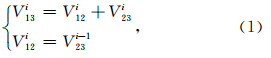
2.1 梯度测量方法流程野外作业时,需同步记录高程Ai及电位差V12i、V13i和V23i.理论上记录的数据应满足公式为
由于观测得到是两点之间的电位差,它不能反映地下的情况,需要把电位差转化为电位.具体的处理方法为
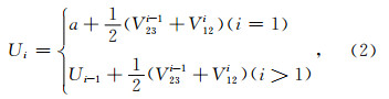
经过(2)式,实测数据所对应的V23和V12的平均值作为测点间的电位差,该电位差再进行叠加得到每点的自然电位.处理时,需按照极差校正→数据叠加→日变改正→地形改正的工作流程.首先消除极差影响,然后对测量数据进行叠加从而将电位差转化为电位,再消除日变影响,最后在极差校正和日变改正的基础上进行地形改正.
2.2 地形改正原理如图 1所示,在自然电位梯度测量中,地形异常分为两种:一是异常与地形影响是镜像关系,这种情况占多数;另一种情况是异常与地形为反镜像关系,在油气勘探中少见(Wang et al.,2007; 王君恒等,2007).多数地形起伏与异常存在三种关系:线性关系、二次关系或指数关系,可利用其进行改正,关系式为
 | 图 1 地形起伏电位示意图Fig. 1 The potential caused by topography |
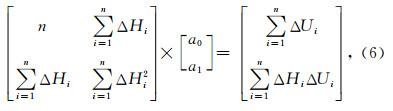
数据处理时,可得到记录高程的点所对应的自然电位.改正时,首先绘制出每条测线的相对高差曲线和自然电位曲线.从相对高差曲线中选取一段变化幅度较大的地形,通过测点号找到其对应的自然电位.这样,就得到了一组相对高差{ΔH1,ΔH2,ΔH3,…,ΔHn}及其对应的自然电位{ΔU1,ΔU2,ΔU3,…,ΔUn},n为所取拟合数据的个数.
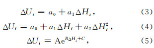
如果设自然电位是关于相对高差的线性函数,即ΔU=f(ΔH)=a0+a1ΔH.应用最小二乘拟合公式为
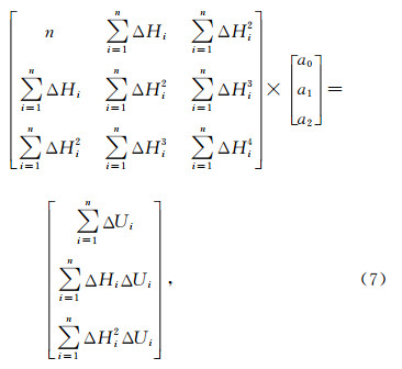
如果设自然电位是关于相对高差的二次函数,即ΔU = f(ΔH)=a0+a1ΔH+a2ΔH2.应用最小二乘拟合公式为
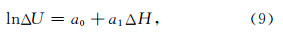
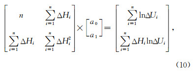
如果设自然电位是关于相对高差的指数函数,即ΔU=f(ΔH)=AeBΔH+C,首先将等号两边同时取对数,可得

工区仍属黄土塬区,区内有数块面积较大的黄土残塬,其余地区被雨水冲刷切割成树枝状水系.大沟中出露白垩系,支沟中为第三系红土或第四系黄土层,黄土层及红土总厚约100~150余米.沟峁梁塬纵横交错,相对高差可达250~300 m.斜坡坡度陡峭且形态规整,是我国境内研究地形改正的最佳地点之一.在东西向部署了5条测线,南北向部署了7条测线.
3.2 拟合数据的选取可用于地形改正的拟合数据需遵照以下原则进行选取:(1)地形起伏较大;(2)地形引起的自然电位异常非常明显;(3)起伏地形与异常形态之间存在较好的对应关系.N1号测线是一条地形起伏较大的测线,测线近似南北向分布,中途经过了两道凹陷的地带.设1300 m为该地区的平均高程,选取高程变化最大的一段数据,绘制其相对高差曲线和自然电位曲线,如图 2所示.
 | 图 2 N1号测线地形起伏较大段相对高差变化和自然电位异常镜像关系Fig. 2 The mirror image relationship between therelative height curve and the spontaneous potentialcurve of the large undulating terrain section of N1 |
可以看到:起伏的地形引起了显著的自然电位变化,对地下地质信息的反映造成了较大干扰.两者之间大致呈现镜像关系,地形每下降200 m,引起的自然电位正异常约为15 mV.其中,测点号310到326、测点号340到352、测点号374到392、测点号400到418之间的地形坡度最大、引起的自然电位异常最为明显,可作为最小二乘拟合所用数据.应用同样的方法从该测区内其他几条测线中选取拟合数据后,得到了一系列相对高差和与之对应的自然电位,如表 1所示.
| | 表 1 用于拟合的相对高差和自然电位原始数据 Table 1 The relative height and their corresponding spontaneous potential that are used for fitting |
若假设相对高差与自然电位之间满足线性函数关系,应用最小二乘拟合公式(6),可计算出参数的值a0 = -2.729、a1 = -0.06497,于是得自然电位改正量与相对高差之间的线性拟合公式为

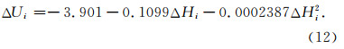
若假设相对高差与自然电位之间满足二次函数 关系,应用最小二乘拟合公式(7),可计算出参数的值 a0=-3.901、a1=-0.1099和a2=-0.0002387,于是得自然电位改正量与相对高差之间的二次拟合公式为
若假设相对高差与自然电位之间满足指数函数 关系,应用最小二乘拟合公式(10),可计算出参数的值a0=-0.08927、a1=-0.01193,亦即A=0.9146、 B=-0.01193、C=0,于是得自然电位改正量与相对高差之间的指数拟合公式为

拟合曲线如图 3所示.
 | 图 3 应用最小二乘公式(6)、(7)和(10)所实现的线性拟合、二次拟合及指数拟合曲线 Fig. 3 The linear fitting, quadratic fitting and exponential fitting curves implemented by applying theleast squares formula (6), (7) and (10) |
从图中可以看出:由于在二次拟合公式(12)中二次项的系数a2很小,因此二次拟合与线性拟合两条曲线非常接近.指数拟合曲线与线性拟合曲线在相对高差(-200 m,-50 m)的区间内较为接近;当相对高差在-50 m以上时,指数拟合公式的地形改正量接近于0.以N5号测线地形起伏较大的一段曲线为例,分析并比较三种不同拟合公式的改正效果.测点号250之后的部分相对高差约为-250 m.分别应用线性、二次和指数拟合公式(11)、(12)和(13),对测线进行改正,改正效果如图 4所示.
 | 图 4 分别应用线性拟合公式、二次拟合公式和指数拟合公式对N5号测线地形起伏较大段所做地形改正前、后自然电位曲线(虚线:改正前自然电位曲线; 实线: 改 正后自然电位曲线)Fig. 4 The spontaneous potential curves of the large undulating terrain section of N5 before and after topography correction by applying the linear fittingformula, the quadratic fitting formula and the exponential fitting formula respectively (dashed line is the spontaneouspotential curve before topography correction; solid line isthe spontaneous potential curve after topography correction) |
可以看到:受下降地形的影响,地形改正前N5号测线自然电位曲线测点号250之后的部分显著向上抬升.对于测点号250之后的部分,三种拟合公式的改正效果无太大差别;对于测点号250之前的部分,线性拟合公式的改正效果最为显著,指数拟合公式几乎没有改正效果.这是由于当相对高差约为-250 m时,三种公式的拟合曲线非常接近(图 3);而当相对高差大于-50 m时,指数拟合公式的地形改正量接近于0(图 3).综上所述:能更好地描述该段测线地形起伏与自然电位之间关系的是线性拟合公式.
3.4 测区的地形改正对测区内全部12条测线(东西向5条+南北向7条)进行了地形改正,绘制出该测区的相对高差等值线图、改正前自然电位等值线图和改正后自然电位等值线图,如图 5—图 7所示.
 | 图 5 该测区的相对高差平面等值线(测量点位以黑色十字标出)Fig. 5 The flat contour map of relative height in the surveyed area (point positions have been marked with black crosses) |
 | 图 6 仅经过极差校正和日变改正的自然电位平面等值线(测量点位以黑色十字标出) Fig. 6 The flat contour map of spontaneous potentialafter contrast correction and diurnal correction (pointpositions have been marked with black crosses) |
 | 图 7 经过极差校正、日变改正和地形改正的自然电位平面等值线(测量点位以黑色十字标出)Fig. 7 The flat contour map of spontaneous potentialafter contrast correction, diurnal correction and topographycorrection(point positions have been marked with black crosses) |
由图可见:由于该地区的地形起伏影响较大,地形改正前的自然电位平面等值线图中呈现出显著的与凹陷地形相关的正异常(图 6中红色线框标注)及与突起地形相关的负异常(图 6中蓝色线框标注).地形改正有效地消除了相对高差与自然电位之间的相关性,从而排除了地形因素给地下地质信息反映所带来的干扰.
4 结论(1)在自然电位梯度测量中,地形异常分为两种:一是异常与地形影响是镜像关系;另一种情况是异常与地形为反镜像关系.多数地形起伏与异常存在一种近似线性、二次或指数关系,可利用该关系进行拟合和改正.
(2)由于地形产生自然电位异常的机理尚不清楚,通过解析方法推导出的地改公式难以得到,可以通过更加直观的方法寻找地形与自然电位之间的拟合公式.本文给出了相对高差与自然电位改正量之间的线性拟合公式、二次拟合公式和指数拟合公式.
(3)自然电位梯度测量中的地形改正,是通过先假定公式、再计算公式中系数的方法求得的.具体采用哪种拟合关系,可以先选取典型的地形及其对应的自然电位曲线,通过其变化规律进行推断;也可以采取试算的办法,通过改正效果的比较选取最为合适的拟合公式.本文对比了三种拟合公式的改正效果,得出线性拟合公式能更好地描述该工区的相对高差与自然电位改正量之间的关系.
(4)地形改正的优劣评价取决于能否消除地形起伏与自然电位之间的相关性.若改正后的自然电位与地形起伏明显不存在镜像关系(或反镜像关系),则说明地形改正是有效的.
| [1] | Bian S F, Zhang K F. 1991. On the role of terrain in the refinement of the geoid in China. Progress in Geophysics (in Chinese), 6(4): 64-74. |
| [2] | Chouteau M, Bouchard K. 1988. Two-dimensional terrain correction in magnetotelluric surveys. Geophysics, 53(6): 854-862. |
| [3] | Dai G M, Luo T Z. 1997. A way of terrain correction for mise—a-la-masse method in 2 dimention. Computing Techniques for Geophysical and Geochemical Exploration (in Chinese), 19(1): 36-40. |
| [4] | Fu L K. 1983. Electrical Prospecting Tutorials (in Chinese). Beijing: Geological Publishing House. |
| [5] | Ge W Z. 1977. Topographic correction for the DC apparent resistivity method of electrical prospecting. Acta Geophysica Sinica (in Chinese), 20(4): 299-311. |
| [6] | Gou C X, Wang H M, Wang B. 2002. Determination of high resolution grid terrain and isostatic corrections in all China area. Acta Geodaetica et Cartographica Sinica (in Chinese), 31(3): 201-205. |
| [7] | Guo D M. 2010. Refined theories, methods and applications of local quasi geoid (in Chinese). Beijing: Graduate School of Chinese Academy of Sciences. |
| [8] | Guo D M, Xu H Z. 2011. Research on the singular integral of local terrain correction computation. Chinese J. Geophys.(in Chinese), 54(4): 977-983, doi: 10.3969/j.issn.0001-5733.2011.04.012. |
| [9] | He J S, Zeng X M. 1984. Fast calculation using polynomes for topographic correction in resistivity method. Geophysical and Geochemical Exploration (in Chinese), 8(1): 27-33. |
| [10] | He Y S, Xia W F. 1978. The Excitation-at-the-Mass Method (in Chinese). Beijing: Geological Publishing House. |
| [11] | Hofmann-Wellenhof B, Moritz H. 2006. Physical Geodesy. Wien: Springer Science & Business Media. |
| [12] | Huang L Z, Tian X M, Cun S C. 1986. The boundary element method of the 2-D topographic correction for the resistivity method in the point source field. Computing Techniques for Geophysical and Geochemical Exploration (in Chinese), 8(3): 201-208. |
| [13] | Huang M T, Zhai G J, Guan Z, et al. 2000. On computations of terrain corrections and indirect effect using FFT. Journal of Institute of Surveying and Mapping (in Chinese), 17(4): 242-246. |
| [14] | Kane M F. 1962. A comprehensive system of terrain corrections using a digital computer. Geophysics, 27(4): 455-462. |
| [15] | Li J C, Chen J Y, Ning J S, et al. 2003. The Approximation Theory of the Earth's Gravitational Field and the Determination of China 2000 Quasi-Geoid (in Chinese). Wuhan: Wuhan University Press. |
| [16] | Li S S, Liu Y Y. 2003. Calculation of the reference orbit of CHAMP by gravitational potential model. Journal of Institute of Surveying and Mapping (in Chinese), 20(3): 165-167. |
| [17] | Li Y C. 1993. Optimized spectral geoid determination. UCSE Report No 20050. Calgary, Alberta, Canada: Geomatics Engineering, University of Calgary. |
| [18] | Li Y L, Wang J H, Pan Z P, et al. 2005. Wavelet multiscale analysis and geophysical significance of the spontaneous potential of oil and gas reservoir. Petroleum Exploration and Development (in Chinese), 32(1): 80-83. |
| [19] | Lin C Y. 1966. The model experimental method of topographic correction in electric profiling method. Acta Geophysica Sinica (in Chinese), 15(1): 66-72. |
| [20] | Lin Z M, Shi Z S. 1984. A discussion on several terrain correction methods in regional gravity survey. Geophysical and Geochemical Exploration (in Chinese), 8(4): 193-198. |
| [21] | Liu L Y, Xin S C. 1992. A topographical correction method for gravity measurement based on a triangular polyhedron. Computing Techniques for Geophysical and Geochemical Exploration (in Chinese), 14(4): 293-300. |
| [22] | Lu Z L. 1989. Improving the Stokes solution of the disturbing potential with the help of topographic data. Acta Geodaetica et Cartographica Sinica (in Chinese), 18(1): 60-71. |
| [23] | Lu Z L. 1996. Theories and Methods of the Earth's Gravitational Field (in Chinese). Beijing: The People's Liberation Army Press. |
| [24] | Maeda K. 1955. Apparent resistivity for dipping beds. Geophysics, 20(1): 123-139. |
| [25] | Ning J S, Luo Z C, Chao D B. 1996. The present situation on satellite gravity gradiometry and its vistas in the application of physical geodesy. Journal of Wuhan Technical University of Surveying and Mapping (in Chinese), 21(4): 309-314. |
| [26] | Novák P, Vaníek P, Martinec Z, et al. 2001. Effects of the spherical terrain on gravity and the geoid. Journal of Geodesy, 75(9-10): 491-504 |
| [27] | Pang Z X. 2008. Research on the refining methods of gravity anomaly (in Chinese). Zhengzhou: The PLA Information Engineering University. |
| [28] | Rong M, Zhou W. 2015. Study on topography correction based on spherical approximation. Journal of Geodesy and Geodynamics (in Chinese), 35(1): 58-61. |
| [29] | Schwarz K P, Sideris M G, Forsberg R. 1990. The use of FFT techniques in physical geodesy. Geophysical Journal International, 100(3): 485-514. |
| [30] | Sideris M G. 1985. A fast Fourier transform method for computing terrain corrections. Manuscripta Geodaetica, 10(1): 66-73. |
| [31] | Sideris M G. 1990. Rigorous gravimetric terrain modelling using Molodensky's operator. Manuscripta Geodaetica, 15(2): 97-106. |
| [32] | Sideris M G, Li Y C. 1993. Gravity field convolutions without windowing and edge effects. Bulletin Géodésique, 67(2): 107-118. |
| [33] | Vaniek P, Novák P, Martinec Z. 2001. Geoid, topography, and the Bouguer plate or shell. Journal of Geodesy, 75(4): 210-215. |
| [34] | Wang J H, Pan Z P, Guan Z N, et al. 2000. Self-potential detection principle of oil/gas reservoir and its application to field development. Petroleum Exploration and Development (in Chinese), 27(3): 96-99, 102. |
| [35] | Wang J H, Pan Z P, Deng M S, et al. 2003. Relationship between spontaneous potential (SP) and apparent effective thickness (AET) of reservoirs. Petroleum Exploration and Development (in Chinese), 30(5): 65-67. |
| [36] | Wang J H, Pan Z P, Sun S W, et al. 2007. Apparent effective thickness prevision through spontaneous potential method and its application in oil development. Earth Science—Journal of China University of Geosciences (in Chinese), 32(4): 461-468. |
| [37] | Wang J H, Pan Z P, Sun S W, et al. 2007. Prediction of apparent equivalent thickness using the spontaneous potential method and its application to oilfield development. Journal of China University of Geosciences, 18(3): 269-279. |
| [38] | Wang Z L, Wen L. 2011. A new terrain correction method. Journal of Geodesy and Geodynamics (in Chinese), 31(3): 115-119. |
| [39] | Wannamaker P E, Stodt J A, Rijo L. 1986. Two-dimensional topographic responses in magnetotellurics modeled using finite elements. Geophysics, 51(11): 2131-2144. |
| [40] | Wichiencharoen C. 1982. The indirect effects on the computation of geoid undulations. Report No. 336. Columbus, OH ,United States: Dept. of Geodetic Science and Surveying, The Ohio State University. |
| [41] | Xu H Z. 2006. Some problems on the precise determination of regional geoid in China. Geospatial Information (in Chinese), 4(5): 1-3. |
| [42] | Xu S Z. 1966. The impact of two-dimensional terrain on resistivity method. Acta Geophysica Sinica (in Chinese), 15(1): 73-82. |
| [43] | Xu S Z, Zhao S K. 1985. The topographic effects on magnetotelluric response. Northwestern Seismological Journal (in Chinese), 7(4): 69-78. |
| [44] | Xu S Z. 1995. The Boundary Element Method in Geophysics (in Chinese). Beijing: Science Press. |
| [45] | Xu S Z, Li Y G, Liu B. 1997. The method and efficiency of 2-D terrain correction for HX-polarization of MT. Acta Geophysica Sinica (in Chinese), 40(6): 842-846. |
| [46] | Zhang C Y, Chao D B, Ding J, et al. 2006. Arithmetic and characters analysis of terrain effects for CM-order precision height anomaly. Acta Geodaetica et Cartographica Sinica (in Chinese), 35(4): 308-314. |
| [47] | Zhang C Y, Chao D B, Ding J, et al. 2009. Precision topographical effects for any kind of field quantities for any altitude. Acta Geodaetica et Cartographica Sinica (in Chinese), 38(1): 28-34. |
| [48] | Zhang C Y, Dang Y M, Ke B G, et al. 2012. Discussion of some lssues in the coastal precise quasi-geoid determination. Geomatics and Information Science of Wuhan University (in Chinese), 37(10): 1150-1154. |
| [49] | Zhou D Y. 2005. An innovation of 3-D non-singular boundary integral equations (in Chinese). Taiwan: National Taiwan University. |
| [50] | Zhou X X, Li X. 1987. Gravimetric terrain corrections by surface integration method. Computing Techniques for Geophysical and Geochemical Exploration (in Chinese), 9(4): 273-279. |
| [51] | 边少锋, 张克非. 1991. 试论地形在我国大地水准面精化中的作用. 地球物理学进展, 6(4): 64-74. |
| [52] | 戴光明, 罗延钟. 1997. 二维地电条件下充电法地形改正的一种方法. 物探化探计算技术, 19(1): 36-40. |
| [53] | 傅良魁. 1983. 电法勘探教程. 北京: 地质出版社. |
| [54] | 葛为中. 1977. 视电阻率法的地形改正. 地球物理学报, 20(4): 299-311. |
| [55] | 郭春喜, 王惠民, 王斌. 2002. 全国高分辨率格网地形和均衡改正的确定. 测绘学报, 31(3): 201-205. |
| [56] | 郭东美. 2010. 局部拟大地水准面精化理论、方法及应用[博士论文]. 北京: 中国科学院研究生院. |
| [57] | 郭东美, 许厚泽. 2011. 局部地形改正的奇异积分研究. 地球物理学报, 54(4): 977-983, doi: 10.3969/j.issn.0001-5733.2011.04.012. |
| [58] | 何继善, 曾宪明. 1984. 电阻率法地形改正的多项式快速计算方法. 物探与化探, 8(1): 27-33. |
| [59] | 何裕盛, 夏万芳. 1978. 充电法. 北京: 地质出版社. |
| [60] | 黄兰珍, 田宪谟, 寸树苍. 1986. 点源场电阻率法二维地形改正的边界元法. 物探化探计算技术, 8(3): 201-208. |
| [61] | 黄谟涛, 翟国君, 管铮等. 2000. 利用FFT技术计算地形改正和间接效应. 测绘学院学报, 17(4): 242-246. |
| [62] | 李建成, 陈俊勇, 宁津生等. 2003. 地球重力场逼近理论与中国2000似大地水准面的确定. 武汉: 武汉大学出版社. |
| [63] | 李姗姗, 刘雁雨. 2003. 利用地球重力场模型计算CHAMP卫星参考轨道. 测绘学院学报, 20(3): 165-167. |
| [64] | 厉玉乐, 王君恒, 潘竹平等. 2005. 油气藏自然电位小波多尺度分解及其地球物理意义. 石油勘探与开发, 32(1): 80-83. |
| [65] | 林崇远. 1966. 电剖面法地形改正的模型实验方法. 地球物理学报, 15(1): 66-72. |
| [66] | 刘立言, 辛舒畅. 1992. 三角面多面体重力地形改正方法. 物探化探计算技术, 14(4): 293-300. |
| [67] | 陆仲连. 1989. 借助地形数据改进扰动位的司托克斯解. 测绘学报, 18(1): 60-71. |
| [68] | 陆仲连. 1996. 地球重力场理论与方法. 北京: 解放军出版社. |
| [69] | 宁津生, 罗志才, 晁定波. 1996. 卫星重力梯度测量的研究现状及其在物理大地测量中的应用前景. 武汉测绘科技大学学报, 21(4): 309-314. |
| [70] | 庞振兴. 2008. 平均空间重力异常精细构制方法研究[硕士论文]. 郑州: 解放军信息工程大学. |
| [71] | 荣敏, 周巍. 2015. 球近似地形改正的研究分析. 大地测量与地球动力学, 35(1): 58-61. |
| [72] | 王君恒, 邓明胜, 潘竹平等. 2000. 油气藏自然电位勘探原理及在开发中的应用. 石油勘探与开发, 27(3): 96-99, 102. |
| [73] | 王君恒, 潘竹平, 邓明胜等. 2003. 油气藏自然电位与油层视有效厚度的关系研究. 石油勘探与开发, 30(5): 65-67. |
| [74] | 王君恒, 潘竹平, 孙树文等. 2007. 自然电位视有效厚度预测及在油田开发中的应用. 地球科学——中国地质大学学报, 32(4): 461-468. |
| [75] | 王增利, 文琳. 2011. 一种地形改正新算法. 大地测量与地球动力学, 31(3): 115-119. |
| [76] | 许厚泽. 2006. 我国精化大地水准面工作中若干问题的讨论. 地理空间信息, 4(5): 1-3. |
| [77] | 徐世浙. 1966. 二度地形对电阻率法的影响. 地球物理学报, 15(1): 73-82. |
| [78] | 徐世浙, 赵生凯. 1985. 地形对大地电磁勘探的影响. 西北地震学报, 7(4): 69-78. |
| [79] | 徐世浙. 1995. 地球物理中的边界单元法. 北京: 科学出版社. |
| [80] | 徐世浙, 李予国, 刘斌. 1997. 大地电磁HX型波二维地形改正的方法与效果. 地球物理学报, 40(6): 842-846. |
| [81] | 章传银, 晁定波, 丁剑等. 2006. 厘米级高程异常地形影响的算法及特征分析. 测绘学报, 35(4): 308-314. |
| [82] | 章传银, 晁定波, 丁剑等. 2009. 球近似下地球外空间任意类型场元的地形影响. 测绘学报, 38(1): 28-34. |
| [83] | 章传银, 党亚民, 柯宝贵等. 2012. 高精度海岸带重力似大地水准面的若干问题讨论. 武汉大学学报·信息科学版, 37(10): 1150-1154. |
| [84] | Chou T Y. 以非奇異性暇積分改善三維邊界積分法. 臺灣大學工程科學及海洋工程學研究所學位論文, 2005: 1-179. |
| [85] | 周熙襄, 李雄. 1987. 重力地形改正的表面积分法. 物探化探计算技术, 9(4): 273-279. |