2. 中国科学院寒区旱区环境与工程研究所冰冻圈国家重点实验室, 兰州 730000;
3. 中国地质大学(武汉)地学院, 武汉 430074;
4. 中国地质科学院地质研究所大陆构造与动力学国家重点实验室, 北京 100029
2. State Key Laboratory of Cryospheric Sciences, Cold and Arid Regions Environmental and Engineering Research Institute, Chinese Academy of Sciences, Lanzhou 730000, China;
3. School of Earth Sciences, China University of Geosciences, Wuhan 430074, China;
4. State Key Laboratory for Continental Tectonics and Dynamics, Institute of Geology, Chinese Academy of Geological Sciences, Beijing 100037, China
1 引言
雅鲁藏布江发源于喜马拉雅山西北部的杰马央宗冰川,从东向西流至东喜马拉雅构造结的南迦巴瓦附近做马蹄形大拐弯,形成了世界最深的峡谷,最大切割深度超过5000 m,称之为雅鲁藏布大峡谷(杨逸畴等,1996; 中国科学院青藏高原综合科学考察队,1984).雅鲁藏布大峡谷入口处发育巨型河流裂点,河流陡降超过2000 m,并且侵蚀强烈,低温热年代学显示最近几十万年侵蚀速率超过10 mm/yr(Burg et al., 1997; Stewart et al., 2008),成为了构造、地表过程和气候相互耦合的研究热点地区(Finnegan et al., 2008; Korup and Montgomery, 2008; Yu et al., 2011; Zeitler et al., 2001; 陈建军等,2008b).最近,通过遥感解译和计算分析冰期时冰川的位置,认为冰期时在雅鲁藏布大峡谷入口处发生的冰川阻江遏制了河流的溯源侵蚀,对大峡谷发育如此显著的河流裂点起到了关键作用(Korup and Montgomery, 2008;Korup et al., 2010),并且可以引发侵蚀能力相当于正常侵蚀两千年的规模巨大的溃决洪水(Lang et al., 2013; Montgomery et al., 2004).而以前的研究多强调构造(Zhang,1998; 杨逸畴,1984)或\和气候(Yu et al., 2011; 孙东霞等,2009)在大峡谷陡峻地貌中的作用.大峡谷入口以上河段及其支流尼洋河广泛分布的湖相沉积,成为评估阻江事件在大峡谷演化中作用的关键地质证据.
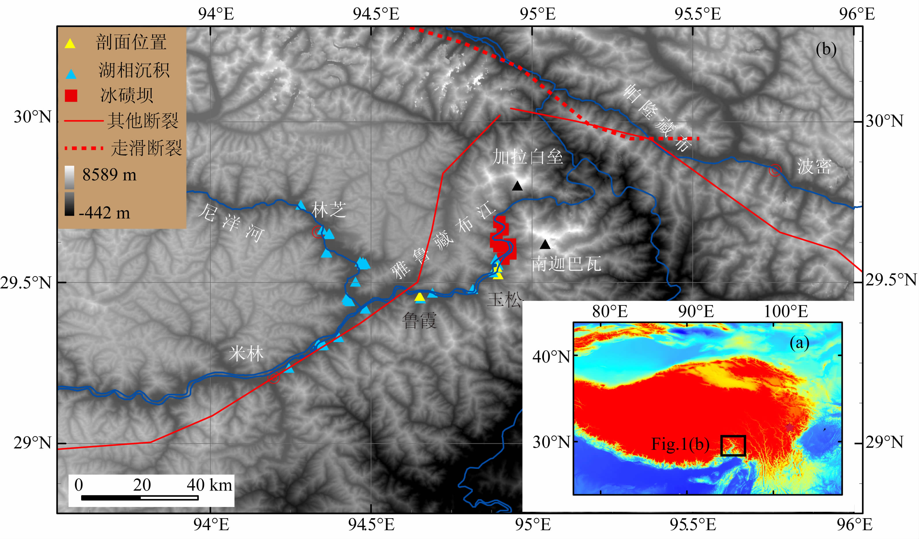
虽然关于该湖相沉积的成因有不同说法,有学者认为是雅鲁藏布江现代水系形成之前的3万年前存在一个古湖(陈建军等,2008a),但很多研究和作者野外工作表明,湖相沉积为堰塞湖的残余(Huang et al., 2007; 王富葆和张厚生,1985; 张文敬,1985).堰塞湖的主要证据如下:湖相沉积沿河道的两岸狭长分布,没有表现出正常的河流形态,并且到峡谷中突然消失,变为冰碛坝的残余(图 1);湖相沉积分布控制在冰碛坝的3180m以下,并且分布在理 论分析的冰川阻江位置之上(Korup and Montgomery, 2008;Korup et al., 2010).因此,该古堰塞湖是冰川阻江形成最有可能,依据沉积物的分布最末端位于格嘎附近,将其命名为格嘎古堰塞湖(Zhu et al., 2012).雅鲁藏布江流域物源分析也表明在3~4 Ma雅鲁藏布江已经从大峡谷处贯穿,只是中间被堰塞坝阻断过(Cina et al., 2009; Zhang et al., 2012).堰塞湖沉积记录了堰塞期间的水文事件(Hanson et al., 2012; Waitt,1985)、地震事件(Jiang et al., 2014; Wang et al., 2011)甚至气候变化信息(Zhang et al., 2011).而格嘎古堰塞湖研究主要围绕湖相沉积、冰碛和河流沉积的年代(陈建军等,2008a; 陈万勇,1980)进行,沉积中的信息研究较 少,仅对米林机场剖面进行过孢粉和磁组构分析,用来指示古气候变化(潘文静等,2013; 朱宗敏等,2007).
磁性矿物广泛存在于地质环境中,地质环境中的任何变化都会引起磁性矿物的某些性质发生变化(Evans and Heller, 2003; Liu et al., 2012).岩石磁学是沉积物研究中的重要手段,已经在湖相沉积 中进行了广泛的应用(Chen et al., 2013; Hu et al., 2002; Su et al., 2013). 本文报告了格嘎古堰塞湖两个地点湖相沉积岩石磁学研究的初步成果,为将岩石磁学手段进一步用于解译该堰塞湖的信息打下了坚实的基础.
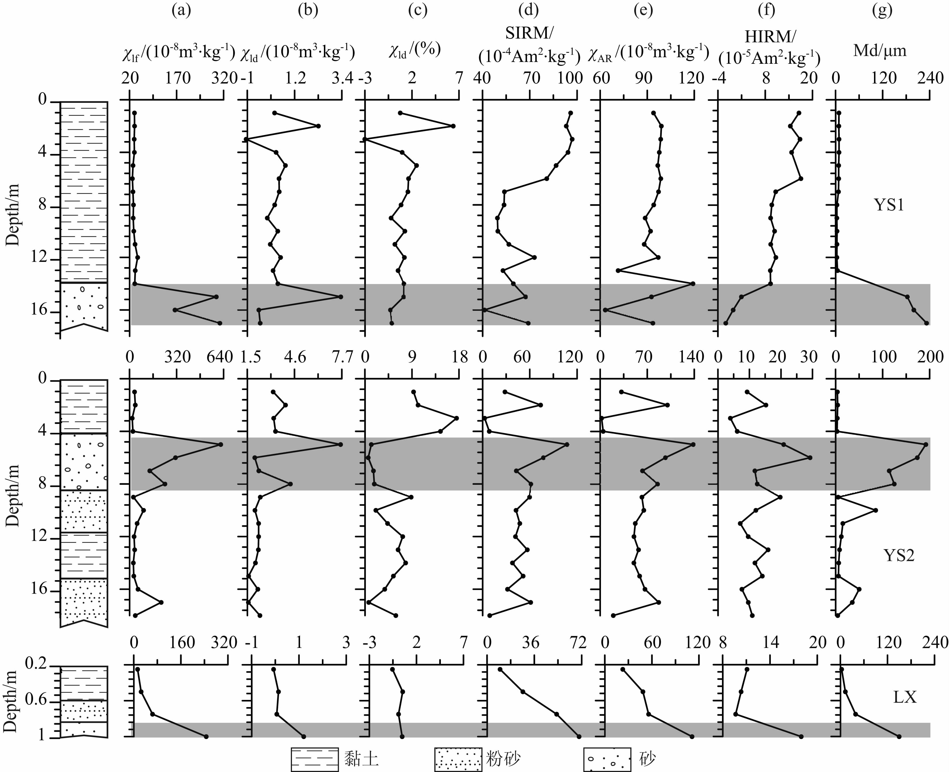
2 样品的采集和实验 2.1 样品的采集本次研究共采集了3个剖面,均位于雅鲁藏布江的右岸,大峡谷入口附近,属于西藏米林县境内(图 1).米林县年均温8.2 ℃,年降水量662.1 mm,降水主要集中于夏秋季节的5至9月,占到了83%(中国科学院登山科学考察队,1996),季风气候特征显著.2个剖面位于玉松村的同一湖相沉积台地,分别命名为YS(玉松)1和YS2,中间约十几米覆盖严重,未有湖相沉积出露.两个剖面中包含有松散砂层,又有泥质粉砂纹泥层(图 2a,b).以约1 m等间距采集样品,上部YS1剖面(北纬29°32.951′,东经94°53.632′,海拔3079 m)采集17个样品,下部YS2 剖面(北纬29°33.020′,东经94°53.733′,海拔3058 m)采集18个样品.另外1个采样剖面位于鲁霞村,剖面(LX,北纬29°27.502′,94°39.418′,海拔2972 m)底部呈现明显的砂层至泥质粉砂的过渡(图 2c),从泥质粉砂层至砂层约25 cm间距采集了4个样品.
 | 图 1 研究区湖相沉积的分布及采样剖面的位置 Fig. 1 The distribution of lacustrine sediments at study areas |
 | 图 2 玉松和鲁霞湖相沉积特征,其中(a)为YS1剖面,(b)为YS2剖面,(c)为LX剖面 Fig. 2 Characteristics of lacustrine sediments:(a)YS1 section;(b)YS2 section;(c)LX section |
玉松剖面已有的两个常规14C定年结果分别为 19.61±2.26 kyr B.P.(郑来林等,2004)和21.096± 1.466 kyr B.P.(Zhu et al., 2012).鲁霞(LX)剖面我们在美国Beta实验室测试的一个AMS14C年代 为40.06±0.88 kyr B.P.,已有的OSL年代为70.4±0.88 kyr B.P.(陈建军等,2008a).这些年代结果均显示古堰塞湖存在于末次冰期,符合冰期时由于冰川延伸至河道而形成堰塞湖的一般规律.
2.2 实验样品自然风干后选取约10 g 左右,用保鲜膜压实,放入2 cm×2 cm×2 cm的专用无磁塑料盒子中,并称重.首先利用Bartington 公司MS2 型磁化率仪分别在低频(0.47 kHz)和高频(4.7 kHz)下进行常温磁化率测量,并质量归一化为质量磁化率χlf和χhf,同时计算频率磁化率 χfd=χlf- χhf和其相对值χfd%=(χlf-χhf)/χlf×100%.利用 LDA-3A交变退磁仪在峰值为100 mT 的交变场中施加100 μT 的直流场,获得样品的非磁滞剩磁(ARM).并且按照刘青松和邓成龙(2009)的方法计算非磁滞剩磁磁化率(ARM).利用强磁仪MMPM10加1T的直流场获得样品的饱和等温剩磁(SIRM);然后再反方向加20 mT后,从40 mT开始以10 mT等间距加至样品剩磁方向反 向,用于计算剩磁矫顽力(Bcr).再加100 mT和300 mT 的反向场,用于计算S-0.3T、HIRM和L-ratio,S-0.3T = 0.5×([-IRM-0.3T /SIRM]+1)×100%,HIRM= 0.5×(SIRM+IRM-0.3T),L-ratio=HIRM/[0.5×(SIRM+IRM-100 mT)(Liu et al., 2007).所有剩磁测量在Minispin 旋转磁力仪上完成.依据剖面磁性参数变化,选择了2个典型样品利用卡巴桥KLY-3磁化率仪与CS-3加热装置,测试了加热和冷却过程磁化率变化(χ-T),整个过程中样品处于氩气环境下,加热最高温度为700 ℃.也利用VFTB 居里天平测试了这两个样品的等温剩磁(IRM)、反向场退磁曲线和磁滞回线.上述磁学 实验均在兰州大学西部环境教育部重点实验室完成.
为了解释磁学参数的影响因素,对堰塞湖沉积也进行了粒度测试.粒度采用Ding(1999)方法(Ding et al., 1999),实验步骤为,加入浓度10%的分散剂,并超声振荡后在英国Malvem公司的Mastersizer 2000型激光粒度仪上测量.粒度实验是在中国科学院水利部成都山地灾害与环境研究所东川野外观测站内完成.
3 结果 3.1 磁性参数随剖面深度变化特征χlf反映了样品中总体磁性矿物的含量.三个剖 面的χlf均变化较大,YS1剖面的 χlf位于(29~308)× 10-8m3/kg之间,YS2剖面的 χlf为(18~620)× 10-8m3/kg,LX剖面的 χlf为(13~246)×10-8m3/kg(图 3a).并且磁化率高值与粒度中值粒径(Md)指示的砂层相对应.若砂层按照粒度的中值粒径大于 100 μm计,则三个剖面砂层 χlf平均291×10-8m3/kg,泥质和粉砂层 χlf平均42×10-8m3/kg.除了玉松2剖面的顶部外,其余 χfd和χfd%均较小,χfd小于4×10⁻⁸ m3/kg,χfd%小于5%(图 3b,c),表明细颗粒磁性矿物的含量很少. χARM和SIRM均差别较小,SIRM变化于(9~110)×10-4Am2/kg之间,砂层平均67.1×10-4Am2/kg,泥质和粉砂层平均为 52.9×10⁻⁴Am2/kg. χARM变化于0~120×10-8m3/kg,砂层平均93.1×10-8m3/kg,泥质和粉砂层平均为69.9×10-8m3/kg,表明稳定单畴的磁性矿物含量差别不大.HIRM代表的高矫顽力的磁性矿物含量变化相对复杂,YS1剖面中砂层的相对较低,而YS2和LX剖面相对较高.
 | 图 3 三个剖面磁学参数和粒度特征,其中灰色框为低频磁化率高值范围
Fig. 3 Magnetic properties and grain size of three sections. The shadow indicates the samples with high magnetic susceptibility |
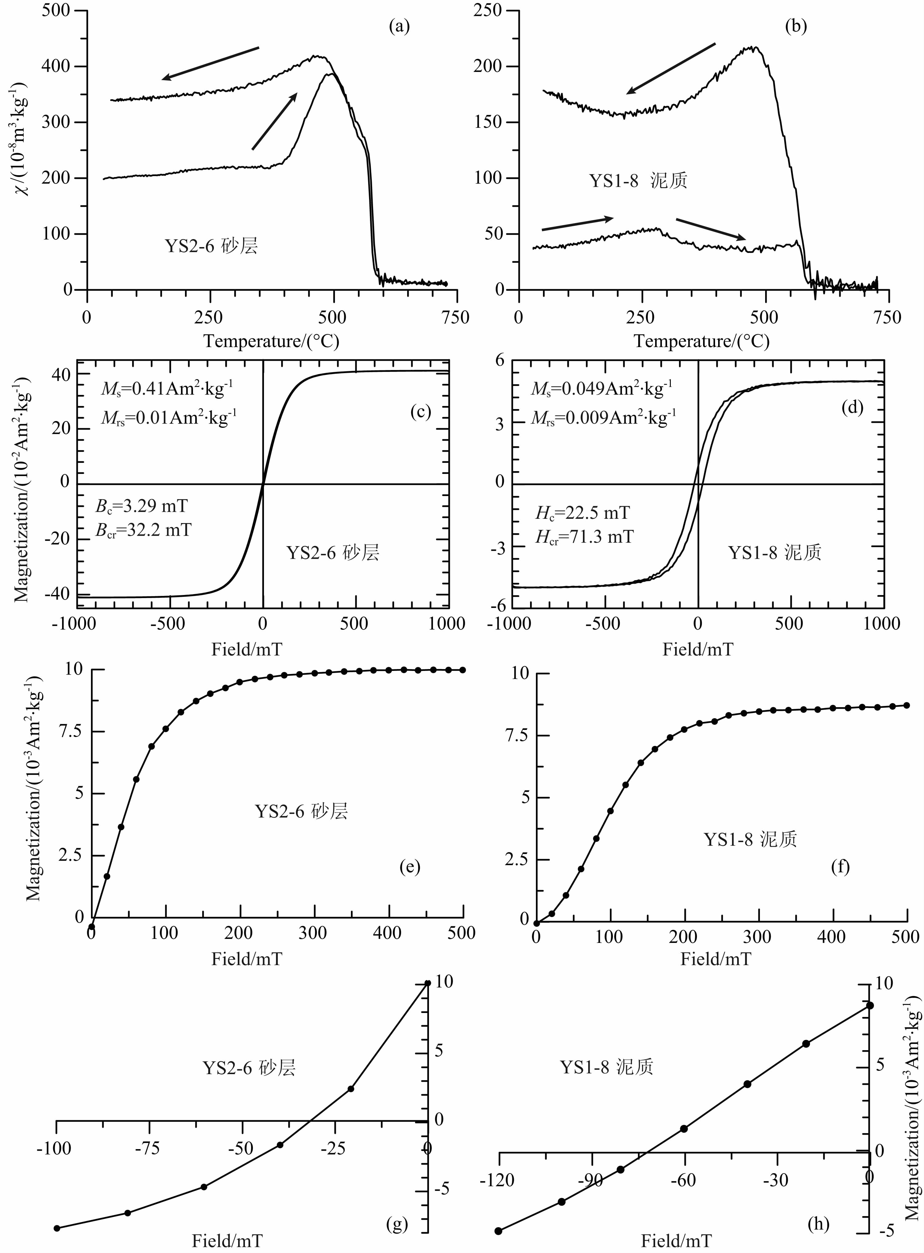
χ-T显示2个样品均在加热至585 ℃左右出现明显的降低,而且降低至零附近,为磁铁矿的典型特征(图 4a).砂层样品加热曲线均显示400 ℃以下变化相对较小,较为平直,此为粗颗粒磁铁矿的特征(Deng et al., 2005),加热曲线在510 ℃左右出现 明显的峰值,可能是单畴和准单畴磁铁矿Hopkinson 效应和新生成强磁性矿物共同作用的结果(刘青松和邓成龙,2009).泥质样品磁化率从室温至250 ℃逐渐升高(图 4b),这一特征通常是由于超细粒磁性颗粒(超顺磁/单畴界线附近的磁性颗粒,SP/SD)解阻造成(Liu et al., 2005),并且在300~500 ℃呈现明显的降低(图 4b),可能是强磁性的硫化物胶黄铁矿等或者磁赤铁矿受热分解特征(Hu et al., 2000;Liu et al., 2005),所有样品的冷却曲线均位于加热曲线之上,是加热过程中新生成磁铁矿的特征,新生成的磁铁矿主要来自样品中含铁粘土矿物/ 硅酸盐矿物的分解、转化(Deng et al., 2005),或者是有机质燃烧导致的还原作用(Liu et al., 2005).
 | 图 4 砂层和泥质沉积的 χ-T、Loop和IRM 特征 Fig. 4 χ-T,Loop and IRM curves of fine s and and clay samples |
两个样品的磁滞回线形态非常相似,均在 500 mT 以下就接近饱和,反映了样品中均以低矫顽力磁性矿物为主.泥质样品比砂层样品的磁滞回线较宽,反映了黏土中的高矫顽力的磁性矿物比例较高(图 4c,d).随着外磁场的增加,IRM快速增加(图 4e,f).在磁场强度为 300 mT时获得的IRM强度均超 过SIRM的80%以上,反映了样品中载磁矿物以低矫顽力磁组分(如磁铁矿、磁赤铁矿)为主.在300 mT 以后,IRM 随着外磁场的增加而缓慢增加,在外磁场达到500 mT时,IRM仍未达到饱和,表明了样品中存在高矫顽力的磁组分(如针铁矿或赤铁矿等).砂层样品的剩磁矫顽力(Bcr)为32.2 mT,泥质样品的为71.3 mT,砂层的矫顽力较低,可能指示了其中包含的磁性颗粒相对较粗.
总之,χ-T、Loop和IRM研究表明,砂层和泥 质样品的磁性矿物均以磁铁矿为主,并且砂层的磁性颗粒相对较粗.
4 讨论 4.1 磁性变化机制本研究的三个堰塞湖沉积剖面均出现砂层χlf明显较高,但指示细颗粒磁性含量的χfd和χARM却变化不显著,结合前面的岩石磁学结果分析,说明砂层磁化率较高可能是因为含有较多的粗颗粒的磁铁矿.砂层中指示磁性颗粒粒度的 χARM/χlf值较小(图 5b),反应了磁性颗粒较粗(Evans and Heller, 2003). χARM/SIRM在砂层中没有明显的降低(图 5c),可能由于SIRM不同于Ms(饱和剩磁),也受到磁性矿物粒径的影响.砂层中Bcr较低(图 5d),同样指示了磁性颗粒较粗.S-0.3T值较大,特别是在砂层中超过了0.9,反映了低矫顽力的磁性矿物占据了绝对优势.反映高矫顽力磁性矿物自身性质差异的L-ratio(Liu et al., 2007)在YS1和LX剖面砂层中显著较低,指示了物源存在变化或沉积物中高矫顽力磁性矿物发生过破坏.
 | 图 5 磁学参数比值和剩磁矫顽力变化特征,其中灰色框为低频磁化率高值范围
Fig. 5 Interparametric ratios of magnetic proxies and coercivity of remanence. The shadow indicates the samples with high magnetic susceptibility |
总之,格嘎古堰塞湖沉积的砂层磁化率较高主要由于含有较多的粗颗粒磁铁矿.湖相沉积中磁性矿物受到的影响因素较多,变化复杂,与沉积过程没有简单的对应关系.格嘎古堰塞湖沉积的磁化率变化模式与有些湖相沉积的磁化率响应机制不同,如呼伦贝尔湖的泥质沉积物的磁化率较高,砂质沉积物的磁化率较低,解释为沉积较粗时,湖面较浅,磁铁矿遭到破坏使磁化率较低;当湖较深时,还磁性矿物不仅容易保存,而且还原环境中还新生成了许多铁硫化物,使磁化率较高(Hu et al., 2000; 胡守云等,1995).也有些湖泊较深时,在还原环境中导致磁铁矿和赤铁矿的溶解,使磁化率显著降低(Ao et al.; 2010).
4.2 磁化率变化对堰塞湖演化的指示意义通常由于堰塞坝的不稳定,堰塞湖会发生多次湖面快速上升和下降.由于冰坝的密度小于水,当冰川堰塞湖的湖面上升至一定的高度后,在水压的作用下,在坝体底部容易形成底部流,而发生溃决,溃决后,冰坝重新下沉而使堰塞湖继续蓄水,因此形成溃决-再生的循环(Waitt,1985).除了冰下流,冰坝自身融化和冰川不断补充等,也会造成冰川堰塞湖发生多次溃决填充.北美的Missoula古冰川堰塞湖 曾经发生过几十次甚至上百次的溃决洪水(Atwater,1984; Hanson et al., 2012; Waitt,1985; Waitt et al., 2009),爱尔兰的Grönalón冰湖20世纪以来已经发生了45次溃决(Roberts et al., 2005),反映了冰川堰塞湖不稳定性普遍存在.
格嘎古堰塞湖沉积中存在多个砂层,砂层主要可能有两种成因,一种为堰塞湖发生溃决,湖泊水深较浅,而形成近岸或湖滨沉积;另外一种情况,可能是堰塞湖周边突发性洪水的水动力较强而带来的粗颗粒沉积.岩石磁学研究表明,这些砂层的 χlf较高,包含的磁性矿物没有经历明显的破坏,表明其为近源的快速沉积,没有经过长距离的搬运破坏,应为湖泊较浅时的沉积.沉积后也没有经历过近岸带水和空气介质的反复分解和破坏,而被快速埋藏.这些沉积特征指示格嘎古冰川堰塞湖与北半球高纬的冰川堰塞湖类似,一个砂层代表了一次溃决洪水事件,这也得到了尼洋河旁湖相沉积中砂层的沉积分析的支持(Chen et al., 2008).格嘎古堰塞湖范围内多处出露几十米至上百米的湖相沉积,其中包含多个砂层,可能包含了多次溃决洪水,岩石磁学研究结合沉积分析和年代研究可以确定堰塞湖的演化历史.
5 结论通过以上分析,初步得出如下结论,格嘎古堰塞湖沉积中的砂层χlf为291×10-8m3/kg,而泥质沉积的χlf仅为42×10-8m3/kg.砂层中包含较多的粗颗粒磁铁矿是 χlf较高的主要原因,说明砂层为近源沉积,并且被快速埋藏.因此,湖相沉积中的砂层指示了堰塞湖溃决事件,为进一步将岩石磁学研究应用到格嘎古堰塞湖沉积研究中提供了一个良好的开端.
致谢 福建师范大学刘秀铭教授和吕斌博士,在岩石磁学实验中给予了帮助,中国科学院东川泥石流野外观测站洪勇和黎晓宇在粒度测试中提供了帮助,樊晓一副教授在野外采样过程中提供了帮助,在此表示感谢.| [1] | Ao H, Deng C L, Dekkers M J, et al. 2010. Magnetic mineral dissolution in Pleistocene fluvio-lacustrine sediments, Nihewan Basin (North China). Earth and Planetary Science Letters, 292(1-2): 191-200. |
| [2] | Atwater B F. 1984. Periodic floods from glacial Lake Missoula into the Sanpoil arm of glacial Lake Columbia, northeastern Washington. Geology, 12(8): 464-467. |
| [3] | Burg J P, Davy P, Nievergelt P, et al. 1997. Exhumation during crustal folding in the Namche-Barwa syntaxis. Terra Nova, 9(2): 53-56. |
| [4] | Chen F, Liu J, Xu Q, et al. 2013. Environmental magnetic studies of sediment cores from Gonghai Lake: implications for monsoon evolution in North China during the late glacial and Holocene. Journal of Paleolimnology, 49(3): 447-464. |
| [5] | Chen J J, Ji J Q, Gong J F, et al. 2008a. Formation of the Yarlung Zangbo Grand Canyon, Tibet, China. Geological Bulletin of China (in Chinese), 27(4): 491-499. |
| [6] | Chen J J, Ji J Q, Yu S L. 2008b. Quantitative analysis of geomorphologic response time-scale of the Yarlung Zangbo Great Canyon. Quaternary Sciences (in Chinese), 28(2):264-272. |
| [7] | Chen W Y. 1980. Natural environment of late Cenozoic in Linzhi basin, Tibet. Vertebrata Palasiatica ( in Chinese), 18(1): 52-58. |
| [8] | Chen Y, Huang S, Lin Y, et al. 2008. Holocene megafloods? Stories of the lacustrine strata along the Nyang River, Tibet. AGU Fall Meeting Abstracts, 1404. |
| [9] | Cina S E, Yin A, Grove M, et al. 2009. Gangdese arc detritus within the eastern Himalayan Neogene foreland basin: Implications for the Neogene evolution of the Yalu-Brahmaputra River system. Earth and Planetary Science Letters, 285(1-2): 150-162. |
| [10] | Deng C L, Vidic N J, Verosub K L, et al. 2005. Mineral magnetic variation of the Jiaodao Chinese loess/paleosol sequence and its bearing on long-term climatic variability. Journal of Geophysical Research: Solid Earth, 110(B3): B03103, doi: 10. 1029/2004JB003451. |
| [11] | Ding Z L, Ren J Z, Yang S L, et al. 1999. Climate Instability During the Penultimate Glaciation: Evidence from Two High-Resolution Loess Records, China. Journal of Geophysical Research, 104(B9): 20123-20132. |
| [12] | Evans M E, Heller F. 2003. Environmental Magnetism: Principles and Applications of Enviromagnetics. Amsterdam: Academ: 382. |
| [13] | Finnegan N J, Hallet B, Montgomery D R, et al. 2008. Coupling of rock uplift and river incision in the Namche Barwa-Gyala Peri massif, Tibet. Geological Society of America Bulletin, 120(1-2): 142-155. |
| [14] | Hanson M A, Lian O B, Clague J J. 2012. The sequence and timing of large late Pleistocene floods from glacial Lake Missoula. Quaternary Science Reviews, 31: 67-81. |
| [15] | Huang S Y, Lin Y N, Chen Y G, et al. 2007. The implication of elevated lacustrine sediments in the middle reach of the Yarlung-Tsangpo and Nyang River, Tibet. AGU Fall Meeting Abstracts, 1081. |
| [16] | Hu S Y, Deng C L, Appel E, et al. 2002. Environmental magnetic studies of lacustrine sediments. Chinese Science Bulletin, 47(7): 613-616. |
| [17] | Hu S Y, Ji L, Wang S M, et al. 1995. Magnetic susceptibility of the Late Quaternary lacustrine sediments and its influence factors in Jula Nur, Hu Lun Lake area. Journal of Lake Sciences (in Chinese), 7(1): 33-40. |
| [18] | Hu S Y, Wang S M, Appel E, et al. 2000. Environmental mechanism of magnetic susceptibility changes of lacustrine sediments from Lake Hulun, China. Science China Earth Sciences, 43(5): 534-540. |
| [19] | Jiang H C, Mao X, Xu H Y, et al. 2014. Provenance and earthquake signature of the last deglacial Xinmocun lacustrine sediments at Diexi, East Tibet. Geomorphology, 204: 518-531. |
| [20] | Korup O, Montgomery D R. 2008. Tibetan plateau river incision inhibited by glacial stabilization of the Tsangpo gorge. Nature, 455: 786-789. |
| [21] | Korup O, Montgomery D R, Hewitt K. 2010. Glacier and landslide feedbacks to topographic relief in the Himalayan syntaxes. Proceedings of the National Academy of Sciences of the United States of America, 107(12): 5317-5322. |
| [22] | Lang K A, Huntington K W, Montgomery D R. 2013. Erosion of the Tsangpo Gorge by megafloods, Eastern Himalaya. Geology, 41(9): 1003-1006. |
| [23] | Liu Q S, Deng C L. 2009. Magnetic susceptibility and its environmental significances. Chinese J. Geophys. (in Chinese), 52(4): 1041-1048 |
| [24] | Liu Q, Deng C, Yu Y, et al. 2005. Temperature dependence of magnetic susceptibility in an argon environment: implications for pedogenesis of Chinese loess/palaeosols. Geophysical Journal International, 161(1): 102-112. |
| [25] | Liu Q S, Roberts A P, Torrent J, et al. 2007. What do the HIRM and S-ratio really measure in environmental magnetism? Geochemistry Geophysics Geosystems, 8(9): Q09011, doi:10.1029/2007GC001717. |
| [26] | Liu Q S, Roberts A P, Larrasoana J C, et al. 2012. Environmental magnetism: Principles and applications. Reviews of Geophysics, 50(4): RG4002, doi: 10. 1029/2012RG000393. |
| [27] | Montgomery D R, Hallet B, Liu Y P, et al. 2004. Evidence for Holocene megafloods down the Tsangpo River gorge, southeastern Tibet. Quaternary Research, 62(2): 201-207. |
| [28] | Mountaineering and Expedition Team of Chinese Academy of Sciences. 1996. Physical Geography and Natural Resources in the Mount Namjagbarwa Region (in Chinese). Beijing: Science Press. |
| [29] | Pan W J, Yu J X, Chang C, et al. 2013. Vegetation succession and environmental transition during late Pleistocene in Milin Area, Tibetan Plateau. Geological Science and Technology Information (in Chinese), 32(3): 6-11. |
| [30] | Roberts M J, Pálsson F, Gudmundsson M T, et al. 2005. Ice-water interactions during floods from Grönalón glacier-dammed lake, Iceland. Annals of Glaciology, 40(1): 133-138. |
| [31] | Stewart R J, Hallet B, Zeitler P K, et al. 2008. Brahmaputra sediment flux dominated by highly localized rapid erosion from the easternmost Himalaya. Geology, 36(9): 711-714. |
| [32] | Sun D X, Ji J Q, Zhang Z C, et al. 2009. AFT dating of detrital apatites from the Yarlung Zangbo Great Canyon: Implications for its distinct geomorphological evolution. Chinese Science Bulletin (Chinese Version), 54(23): 3738-3747. |
| [33] | Su Y L, Gao X, Liu Q S, et al. 2013. Mechanism of variations in environmental magnetic proxies of lake sediments from Nam Co, Tibet during the Holocene. Chinese Science Bulletin, 58(13): 1568-1578. |
| [34] | Tibetan Plateau Integrated Survey Team of Chinese Academy of Sciences. 1984. Rivers and Lakes in Tibet (in Chinese). Beijing: Science Press. |
| [35] | Waitt R B. 1985. Case for periodic, colossal jkulhlaups from Pleistocene glacial Lake Missoula. Geological Society of America Bulletin, 96(10): 1271-1286. |
| [36] | Waitt R B, Denlinger R P, O'Connor J E. 2009. Many monstrous Missoula floods down Channeled Scabland and Columbia Valley. Field Guides, 15: 775-844. |
| [37] | Wang F B, Zhang H S. 1985. Quaternary geology side light in Mt. Namjagbarwa area. Mountain Research (in Chinese), 3(4): 321-324. |
| [38] | Wang P, Zhang B, Qiu W, et al. 2011. Soft-sediment deformation structures from the Diexi paleo-dammed lakes in the upper reaches of the Minjiang River, east Tibet. Journal of Asian Earth Sciences, 40(4): 865-872. |
| [39] | Yang Y C. 1984. The geomorphologic characters and the origin in the Mt. Namjagbarwa region. Mountain Research (in Chinese), 2(3): 134-141. |
| [40] | Yang Y C, Gao D Y, Li B S. 1996. A great geographical discovery in the end of 20th century-demonstration on the Yarlung Zangbo river valley as the greatest canyon in the world. Geographical Research (in Chinese), 15(4): 1-9. |
| [41] | Yu X J, Ji J Q, Gong J F, et al. 2011. Evidences of rapid erosion driven by climate in the Yarlung Zangbo(Tsangpo) Great Canyon, the eastern Himalayan syntaxis. Chinese Science Bulletin, 56(11): 1123-1130. |
| [42] | Zeitler P K, Meltzer A S, Koons P O, et al. 2001. Erosion, Himalayan geodynamics, and the geomorphology of metamorphism. GSA Today, 11: 4-9. |
| [43] | Zhang D D. 1998. Geomorphological problems of the middle reaches of the Tsangpo River, Tibet. Earth Surface Processes and Landforms, 23(10): 889-903. |
| [44] | Zhang J Y, Yin A, Liu W C, et al. 2012. Coupled U-Pb dating and Hf isotopic analysis of detrital zircon of modern river sand from the Yalu River (Yarlung Tsangpo) drainage system in southern Tibet: Constraints on the transport processes and evolution of Himalayan rivers. Geological Society of America Bulletin, 124(9-10): 1449-1473. |
| [45] | Zhang W J. 1985. Some features of the surge glacier in the Mt. Namjagbarwa. Journal of Mountain Research (in Chinese), 3(4): 234-238. |
| [46] | Zhang Y S, Zhao X T, Lan H X, et al. 2011. A Pleistocene landslide-dammed lake, Jinsha River, Yunnan, China. Quaternary International, 233(1): 72-80. |
| [47] | Zheng L L, Liao G Y, Geng Q R, et al. 2004. New results and major progress in regional geological survey of Medog County Sheet. Geological Bulletin of China (in Chinese), 23(5-6): 458-462. |
| [48] | Zhu S, Wu Z H, Zhao X T, et al. 2012. Middle-Late Pleistocene Glacial Lakes in the Grand Canyon of the Tsangpo River, Tibet. Acta Geologica Sinica-English Edition, 86(1): 266-283. |
| [49] | Zhu Z M, Cun J H, Pang L F, et al. 2007. Magnetic properties of lacustrine sediment sand implications for paleoclimate in Milin Area, Tibet. Earth Science-Journal of China University of Geosciences (in Chinese), 32(5): 622-628. |
| [50] | 陈建军, 季建清, 龚俊峰等. 2008a. 雅鲁藏布江大峡谷的形成. 地质通报, 27(4): 491-499. |
| [51] | 陈建军, 季建清, 余绍立. 2008b. 雅鲁藏布江大峡谷地貌响应时间域的定量计算. 第四纪研究, 28(2): 264-272. |
| [52] | 陈万勇. 1980. 西藏林芝盆地新生代晚期的自然环境. 古脊椎动物与古人类, 18(1): 52-58. |
| [53] | 胡守云, 吉磊, 王苏民等. 1995. 呼伦湖地区扎赉诺尔晚第四纪湖泊沉积物的磁化率变化及其影响因素. 湖泊科学, 7(1): 33-40. |
| [54] | 刘青松, 邓成龙. 2009. 磁化率及其环境意义. 地球物理学报, 52(4): 1041-1048. |
| [55] | 潘文静, 喻建新, 常浩等. 2013. 青藏高原米林地区晚更新世晚期植被演替与环境变迁. 地质科技情报, 32(3): 6-11. |
| [56] | 孙东霞, 季建清, 张志诚等. 2009. 雅鲁藏布江中下游流域地貌差异演化的岩屑磷灰石裂变径迹证据. 科学通报, 54(23): 3738-3747. |
| [57] | 王富葆, 张厚生. 1985. 南迦巴瓦峰地区第四纪地质拾零. 山地研究, 3(4): 321-324. |
| [58] | 杨逸畴. 1984. 南迦巴瓦峰地区地貌的基本特征和成因. 山地研究, 2(3): 134-141. |
| [59] | 杨逸畴, 高登义, 李渤生. 1996. 20世纪末的一次重大地理发现──雅鲁藏布江大峡谷为世界之最的论证. 地理研究, 15(4): 1-9. |
| [60] | 张文敬. 1985. 南迦巴瓦峰跃动冰川的某些特征. 山地研究, 3(4): 234-238. |
| [61] | 郑来林, 廖光宇, 耿全如等. 2004. 墨脱县幅地质调查新成果及主要进展. 地质通报, 23(5-6): 458-462. |
| [62] | 中国科学院登山科学考察队. 1996. 南迦巴瓦峰地区自然地理与自然资源. 北京: 科学出版社. |
| [63] | 中国科学院青藏高原综合科学考察队. 1984. 西藏河流与湖泊. 北京: 科学出版社. |
| [64] | 朱宗敏, 寸金鸿, 庞龙飞等. 2007. 西藏米林地区湖积物的磁性特征及其古气候意义. 地球科学: 中国地质大学学报, 32(5): 622-628. |
 2014, Vol. 57

