 2014, Vol. 57


2. 蒙古科学院天文与地球物理研究中心, 乌兰巴托
2. Research Center of Astronomy & Geophysics of Mongolian Academy of Sciences, Ulaanbaatar, Mongolia
蒙古地区位于西伯利亚克拉通和华北克拉通与塔里木克拉通之间,且处于中亚造山带(CAOB)的核心位置,是地球上最显著的显生宙陆壳增生与改造的大陆造山带(Badarch et al., 2002).作为壳幔相互作用和构造运动强烈的区域,CAOB发育了复杂的地壳变形和岩浆活动,一直是地球科学研究的前沿热点之一,引起世界地质学家和地球物理学家的普遍关注(Gao et al., 1994,1997,2004; Zorin et al., 1989,2002,2003,2006; Zhao et al., 2006; Lebedev et al., 2006; Mordvinova et al., 2007; Nielsen and Thybo, 2009; Fullea et al., 2012),然而也是目前我们认识较为贫乏的地区之一(Calais et al., 2003).
中亚造山带位于古亚洲洋闭合带,主要由两大板块间的微大陆相互叠覆构成,是现今地球上构造 运动较为活跃的地区之一(Zonenshain and Savostin, 1981). 普遍认为该地区的构造演化主要受太平洋板块的俯冲和消减,以及印度—欧亚板块的碰撞和挤压等过程的共同作用和影响.许多研究认为印度—欧亚板块挤压碰撞的远场效应导致了蒙古高原NNE—SSW地壳缩短(Molnar and Tapponnier, 1975;Barruol et al., 2008;Cunningham,2005;Koulakov,1998;Zonenshain and Savostin, 1981; Peltzer and Tapponnier, 1988;Tapponnier and Molnar, 1979; Baljinnyam et al., 1993;Cunningham et al., 1996; Cunningham,2005)、地幔物质上涌(Khain,1990;Windley and Allen, 1993)、以及蒙古—贝加尔地区应力状态的变化(Petit and Fournier, 2005; Lesne et al., 1998,2000; Polyansky,2002).但也有研究推测蒙古—贝加尔地区的许多构造特征难以简单地归因于印度—欧亚板块的碰撞挤压.一些研究认为,软流圈物质的上涌是贝加尔裂谷拉张(Delvaux et al., 1995;Petit et al., 1996;Delvaux et al., 1997;Lesne et al., 2000;Puzyre et al., 1978)和杭爱山脉隆起(Cunningham,2001;Petit et al., 2002;Kulakov,2008;Xiong et al., 2010)的主要动力来源.截至目前为止对于贝加尔裂谷是主动还是被动裂谷以及杭爱高原的形成等还存在诸多争议.
20世纪80年代以来,地球物理学家们相继对蒙古—贝加尔湖地区进行了许多地球物理探测研究,其中美国加利福尼亚大学洛杉矶分校和威斯康星大学1991年在西伯利亚克拉通和贝加尔裂谷地区布设了36台地震仪进行了为期4个月的地震观测(Gao et al., 1994),1992年又在西伯利亚克拉通、贝加尔裂谷地区以及蒙古褶皱带布设了40台地震仪进行了为期近3个半月的地震观测(Gao et al., 2004);2003年法国、俄罗斯以及蒙古合作的蒙古—贝加尔岩石圈地震观测实验(MOBAL)项目横穿杭爱山脉布设了18个宽频带地震仪,穿越了西伯利亚克拉通、萨彦山脉、杭爱高原以及阿尔泰山脉地区.利用这些观测资料分别开展了接收函数(Mordvinova et al., 2007;Gao et al., 2004;Zorin et al., 2002)、横波分裂(Gao et al., 1994,1997;Barruol et al., 2008)、远震层析成像(Gao et al., 2003;Petit et al., 1998)等研究,并得到了一些有意义的研究成果.其中接收函数以及面波反演等结果显示蒙古地区地壳厚度在44~50 km左右(Gao et al., 2004;Fullea et al., 2012),推测下地壳富含铁镁质(Fullea et al., 2012)或是存在铁镁质的侵入(Nielsen et al., 2009).此外研究表明该区域普遍存在壳内低速层(Zorin et al., 2002;Mordvinova et al., 2007),并且认为这些低速层与软流层的底辟作用有关(Mordvinova et al., 2007).
接收函数方法是目前研究地球内部速度间断面结构较为有效的方法之一.Langdon(1979)根据谱振幅比方法给出了源等效假定,从长周期远震体波中分离出接收函数.Owens(1987)等将其扩展到了宽频带记录,并提出了接收函数的线性反演.之后接收函数经过多种改进(Kind et al., 1995;Yuan et al., 1997;刘启元等,1996;Ligorria and Ammon, 1999;吴庆举等,2007).目前普遍利用H-κ扫描叠加和CCP叠加来获取地壳结构特征.本文拟采取上述两种方法对贝加尔—杭爱山脉与蒙古褶皱带肯特山脉中间区域即蒙古中南部地区的地壳厚度和波速 比进行研究,以期为其整个区域的地壳厚度变化特 征及地壳是否富含铁镁质等提供地球物理的深部证据.
2 数据和方法本研究所用的数据来自中国地震局地球物理研究所与蒙古科学院天文与地球物理研究中心在蒙古中南部地区所架设的流动地震观测台阵在2011年8月至2013年7月期间所观测到的远震波形记录.本文选取的测线主要由12个台站组成,台站间距约为50 km,基本上跨越了蒙古中南部地区的主要构造单元,如图 1所示.在数据处理过程中,我们选取震中距在30°~95°之间,震级5.5级以上(含5.5级)的远震事件,进一步挑选出震相清晰、三分量齐全、垂直分量衰减快且信噪比高(张广成等,2013)的473个远震事件进行接收函数研究.所选远震事件的分布如图 2所示.
 | 图 1 研究区域周边情况及台站分布图 红色三角形为火山,红色五角形为地名,黑色线为断层,L01—L12是台站名,黑色点为台站位置.Fig. 1 Map showing geology of the study area and surrounding regions and distribution of seismic stations Red triangles denote volcanoes. Red pentagons denote place names. Black lines represent faults. L01—L12 are station names. Black dots denote station locations. |
地震仪器记录到的地震波信号通常可以用震源时间函数、地震波传播路径响应、震源区域的介质响应、接收区域的介质响应以及仪器响应的褶积来表示.对于远震地震事件记录而言,其到达接收台站的地震波可以视为陡角度入射的平面波.利用远震P波波形数据的垂直分量对径向和切向分量做反褶积可从中基本去除震源时间函数与传播路径的影响,进而提取到接收区介质响应的径向分量和切向分量,也就是我们要求的P波接收函数(吴庆举和曾融生,1998).
本文采用时间域反褶积方法来计算接收函数.在提取接收函数之前,首先对数据做以下处理:(1)截取P波到时前50 s,后150 s,在这一时间段内的波形几乎包含了地球内部各个界面所产生的转换震相(武岩,2011);(2)对截取的数据进一步去除仪器响应,去倾斜,去均值,重采样,并用0.05~2 Hz的 频率范围进行带通滤波,从而去除仪器响应和地下倾斜界面等影响;(3)挑选三分量齐全,震相清晰且垂直分量衰减快的地震事件,有助于在做接收函数褶积时较快地收敛;(4)检查数据参数(射线参数、分量方位角等).
 | 图 2 所用远震事件震中分布Fig. 2 Epicentral distribution of teleseismic events used in this study |
接收函数记录中,紧随直达P波之后的是来源于Moho面的转换震相主要为Ps转换波和PpPs以及PpSs+PsPs地表多次波.利用这些转换震相和地表多次波与直达P波的到时关系即公式(1),可以有效约束Moho界面的深度与地壳平均波速比.其中,H为地壳厚度,VP为P波速度,VS为S波速度,p是射线参数,tPs是Ps震相与P波的到时差,同理tPpPs是PpPs震相与P波的到时差,tPpSs+PsPs是PpSs+PsPs震相与P波的到时差.
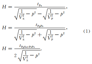
在进行H-κ(κ=VP/VS)叠加时,每个H和κ都 会对应一个到时,根据到时可以获得其在接收函数中对应的振幅,这些振幅按照公式(2)进行叠加,对在一定范围内的H和κ进行扫描,得到最大振幅的位置,即是求得的H和κ值,这种方法便是H-κ叠加.公式(2)中,ω1,ω2,ω3是振幅叠加的加权系数,基于三震相信噪比顺序减小的特点,本文在H-κ叠加时,加权值分别取0.6,0.3和0.1,初始速度模型为IASP91,H和κ的搜索步长分别为0.5 km和0.01.在s(H,κ)取得最大值时,对其进行泰勒展开,略去 高阶项,便得到s(H,κ)的方差(Zhu and Kanamori, 2000),见公式(3).
 | 图 3 H-κ叠加方法获得的地壳厚度和VP/VS波速比估计Fig. 3 Estimation of crustal thickness and VP/VS ratio by H-κ stacking method |
共转换点叠加(CCP)方法是根据共反射点叠加原理提出来的转换波界面成像方法(Dueker and Sheehan, 1997),可以获得直观的叠加剖面,通过叠加可以凸显弱转换波震相、压制多次波、提高信噪比(Zhu,2000).在CCP叠加中,首先对台站下方结构进行网格划分,分成若干个共转换点面元,同时根据初始速度模型进行反向的射线追踪(本文所用初始速度模型为IASP91)获取射线路径.将接收函数的每个振幅看作某个对应深度界面所产生的转换波,并反投影到对应的理论转换点.对同一共转换点面元内的所有接收函数的转换波进行叠加,这样转换振幅由于相长叠加而得到增强,便可对台站下方的速度界面进行成像,获得直观的CCP叠加剖面.为增强莫霍界面的转换波Ps的成像效果,我们还通过调整共转换点单元大小,来增加共转换点单元内参与叠加的射线的数量(武岩等,2011).
3 结果与讨论本文利用H-κ扫描方法得到的地壳厚度以及泊松比如表 1和图 4所示.结果显示研究区地壳厚度整体介于39~45 km之间,均值为42.6 km.L01—L10号台站之间的地壳厚度较厚,平均值为43.3 km,而位于南部戈壁即接近中国边境地区的 L11—L12号台站下方的地壳厚度较薄,约为39 km,两者相差约4.3 km. 同时,CCP叠加方法与H-κ扫描方法得到的结果具有很好的一致性,见图 5(其中圆圈表示H-κ叠加方法获得的地壳厚度去除台站海拔高度所得到的Moho深度,洋红色显示为CCP叠加获取的Moho深度).由图 5可以看出,研究区Moho埋深从西北到东南区域逐渐变浅,且基本上与地形起伏变化趋势相似.上述地壳厚度的区域性变化特征与Gao等(2004)的结果基本一致.他们的结果显示蒙古褶皱带地壳厚度为44~48 km,且地壳从北到南逐渐变薄.
L10和L11台站位于蒙古主构造线附近,从CCP叠加剖图上可以看出L10和L11这两个相邻台站下方的地壳厚度相差较大,达4 km.蒙古主构造线是一个板块消减的缝合带(Kroner et al., 2005;Windley et al., 2007),因此L10和L11台站下方地壳厚度4 km多的突变可能是板块消减缝合带(Kroner et al., 2005;Windley et al., 2007)的深部反映.蒙古主构造线不仅是一个地形与构造上的分界线,将蒙古分为南北两部分,北部主要是前寒武纪和早古生代的地层,南部主要是晚古生代的地层(Badarch et al., 2002),而且也是地壳厚度的陡变带,其南侧地壳减薄,北侧加深.
另外,本文H-κ扫描方法结果表明研究区台站 下方地壳的波速比值介于1.70~1.79(σ为0.235~0.273)之间,均值为1.75,低于全球大陆的平均值1.78(Z and t and Ammon, 1995),但在测线的西北与东南地区即L01、L11、L12号台站的波速比值比较高.研究区的波速比值整体偏低,且存在显著的横向变化,一方面可能暗示着蒙古中南部地区的地壳总体以酸性为主,仅在局部区域保留有铁镁质的地壳,另一方面研究区地壳组分存在明显的横向差异,可能反映了中亚造山带由不同块体构成,也可能与中亚造山带形成后的后期改造有关.
通常而言,地壳的厚度与构成在研究地壳起源和演化中有着紧密的约束关系,而地壳的组分和地壳波速比相关(Ji et al., 2009).鉴于波速比κ=VP/VS,泊松比σ=0.5[1-1/(κ2-1)],因而波速比与泊松比表现为正相关关系.实验表明,温度和压力对泊松比σ影响很小,而泊松比主要是随着岩石的年龄变化的,大陆地壳的泊松比处于0.25~0.27之间(Z and t and Ammon, 1995).从岩石成分上来说,在地壳成分组成中SiO2等矿物的比重越高泊松比越小,反之,则越大(Christensen et al., 1996;李永华等,2006).对于下地壳岩石,波速比值κ<1.75,1.75≤κ≤1.81,以及κ>1.81分别表示岩石是主要由酸性、中性以及基性成分组成,然而整个地壳的波速比相对于下地壳的κ要小一点,大约在0.02左右(Z and t and Ammon, 1995;Christensen,1996;Cahng and Baag, 2007;Niu and James, 2002;Nair et al., 2006;He et al., 2013).地幔物质的侵入是地壳增生的途径之一,而地幔中富含铁镁质,因此这个过程往往伴随着波速比的增大,同时地壳运动的后期改造则可能使波速比逐渐变小.另外,局部熔融对波速比有很大的影响,波速比会随着熔融程度的增加而增大(Watanabe,1993).
测线西北部的L01台附近不仅有新生代火山岩出露(见图 6),而且地质资料显示有晚古生代二叠纪—三叠纪大陆裂谷火山岩出露(任纪舜等,2002).测线东南部L11、L12号台站位于蒙古主构造线的南部,蒙古主构造线的南部主要是古生代志留纪—泥盆纪和石炭纪岛弧火山岩和火山碎屑岩,并被中生代白垩纪盆地不整合覆盖(Windley et al., 2007; 任纪舜等,2002),且在南部的我国境内有新生代火山岩出露.台站L01、L11和L12的波速比分别为1.78、1.77和1.79,与其他台站相比偏高,可能与其附近观测到的新生代火山活动有关,也可能是晚古生代铁镁质地壳残余的反映.
 | 图 4 蒙古中南部地区地壳厚度图Fig. 4 Crustal thickness distribution of central and southern Mongolia |
 | 图 5 蒙古中南部地区CCP叠加剖面图图中虚线为42.5 km深度,圆圈为H-κ叠加方法得到的台站下方的Moho深度.Fig. 5 CCP profile of central and southern MongoliaDashed line is the depth of 42.5 km. Circles are Moho depth from the H-κ stacking method. |
本文的研究结果显示,除个别台站外蒙古中南部地区波速比普遍低于或等于1.76,为此我们推测研究区地壳组分缺乏铁镁质物质.这与前人在本研究区域的北部、西北部以及西部地区获得的研究结果明显不同.面波-岩石学反演研究(Fullea et al., 2012)推测贝加尔南部—蒙古中部地区的下地壳为 铁镁质的.人工地震折射剖面研究发现萨彦—贝加尔褶皱带的下地壳存在一个宽达50~80 km的高速异常,该高速异常也被解释为铁镁质物质的底侵(Nielsen and Thybo, 2009).因此,我们认为铁镁质的下地壳并不是中亚造山带的普遍特征.
 | 图 6 蒙古中南部地区地壳波速比红色钻石形代表火山岩出露(IAVCEI,1973; Whitford-Stark,1987).Fig. 6 Velocity ratios of central and southern MongoliaRed diamonds represent volcano outcrops (IAVCEI,1973; Whitford-Stark,1987). |
本文利用12个宽频地震台站记录到的远震资 料,采用接收函数H-κ扫描叠加方法以及CCP叠加方法获取了台站下方的地壳厚度和波速比值.这两种方法获取的地壳厚度具有很好的一致性.结果表明研究区地壳厚度约在35~45 km之内,且由西北往东南逐渐变薄.本文结果与前人的地壳厚度估值基本一致(Gao et al., 2004).此外,蒙古主构造线两侧台站下方的地壳厚度的陡变特征可能反映蒙古主构造线是一个板块消减的缝合带(Kroner et al., 2005;Windley et al., 2007).台站下方地壳的平均波速比值介于1.70~1.79之间,均值为1.75,推测研究区大部分地壳是缺乏铁镁质的.测线西北与东南地区的波速比值较高,可能反映研究区的西北与东南地区还残留有古生代铁镁质的下地壳,或与新生代火山活动有关.
|
|
表 1 H-κ方法得到的地壳厚度以及波速比 Table 1 Crustal thickness and VP/VS ratio obtained by H-κ stacking method |
致谢 感谢朱露培教授提供的接收函数叠加的程序及技术指导;感谢蒙古科学院天文与地球物理研究中心的相关研究人员以及参与蒙古台站仪器布设、数据提取的全体人员;感谢两位匿名审稿人提出的建设性意见.
| [1] | Badarch G, Cunningham W D, Windley B F. 2002. A new terrane subdivision for Mongolia: implications for the Phanerozoic crustal growth of Central Asia. Journal of Asian Earth Sciences, 21(1): 87-110. |
| [2] | Baljinnyam I, Bayasgalan A, Borisov B A, et al. 1993. Ruptures of major earthquakes and active deformation in Mongolia and its surroundings. Geol. Soc. Am., 181: 62. |
| [3] | Barruol G, Deschamps A, Deverchere J, et al. 2008. Upper mantle flow beneath and around the Hangay dome, Central Mongolia. Earth Planet. Sci. Lett., 274(1-2): 221-233, doi:10.1016/j.epsl.2008.07. 027. |
| [4] | Calais E, Vergnolle M, San'kov V, et al. 2003. GPS measurements of crustal deformation in the Baikal-Mongolia area (1994-2002): implications for current kinematics of Asia. J. Geophys. Res., 108(B10): 2501-2501, doi:10.1029/2002-JB002373. |
| [5] | Cahng S, Baag C. 2007. Moho depth and crustal VP/VS variation in southern Korea from teleseismic receiver functions: Implication for tectonic affinity. Bull. Seism. Soc. Am. , 97(5): 1621-1631. |
| [6] | Christensen N I. 1996. Poisson's ratio and crustal seismology. J. Geophys. Res., 101(B2): 3139-3156. |
| [7] | Cunningham W D, Windley B F, Dorjnamjaa D, et al. 1996. A structural transect across the Mongolian Altai: active transpressional mountain building in central Asia. Tectonophysics, 15(1): 142-156. |
| [8] | Cunningham W D. 2001. Cenozoic normal faulting and regional doming in the southern Hangay region, Central Mongolia: implications for the origin of the Baikal rift province. Tectonophysics, 331(4): 389-411. |
| [9] | Cunningham D. 2005. Active intracontinental transpressional mountain building in the Mongolian Altai: Defining a new class of orogen. Earth Planet. Sci. Lett., 240(2): 436-444, doi:10.1016/j.epsl.2005.09. 013. |
| [10] | Delvaux D, Moeys R, Stapel G, et al. 1995. Palaeostress reconstructions and geodynamics of the Baikal region, Central Asia, Part I. Palaeozoic and Mesozoic pre-rift evolution. Tectonophysics, 252(1-4): 61-101. |
| [11] | Delvaux D, Moeys R, Stapel G, et al. 1997. Paleostress reconstructions and geodynamics of the Baikal region, central Asia: Part II. Cenozoic rifting. Tectonophysics, 282(1-4): 1-38. |
| [12] | Dueker K G, Sheehan A F. 1997. Mantle discontinuity structure from midpoint stacks of converted P to S waves across the Yellowstone hotspot strack. J. Geophys. Res., 102(B4): 8313-8327. |
| [13] | Fullea J, Lebedev S, Agius M R, et al. 2012. Lithospheric structure in the Baikal-central Mongolia region from integrated geophysical-petrological inversion of surface-wave data and topographic elevation. Geochem. Geophys. Geosyst., 13(8): Q0AK09, doi:10.1029/2012GC004138. |
| [14] | Gao S, Davis P M, Liu H, et al. 1994. Seismic anisotropy and mantle flow beneath the Baikal rift zone. Nature, 371(6493): 149-151. |
| [15] | Gao S, Davis P M, Liu H, et al. 1997. SKS splitting beneath continental rift zones. J. Geophys. Res., 102(B10): 22781-22797. |
| [16] | Gao S S, Liu K H, Davis P M, et al. 2003. Evidence for small-scale mantle convection in the upper mantle beneath the Baikal rift zone. J. Geophys. Res., 108(B4): 2194-2194, doi:10.1029/2002JB002039. |
| [17] | Gao S S, Liu K H, Chen C. 2004. Significant crustal thinning beneath the Baikal rift zone: New constraints from receiver functions analysis. Geophys. Res. Lett., 31(20): L20610, doi:10. 1029/2004GL020813. |
| [18] | He C S, Dong S W, Santosh M, et al. 2013. Seismic evidence for a geosuture between the Yangtze and Cathaysia blocks, South China. Scientific Reports, 3: 2200, doi:10.1038/srep02200. |
| [19] | International Association of Volcanology and Chemistry of Earth's Interior. 1973. Post-Miocene Volcanoes of the World. IAVCEI Data Sheets, Rome: Internatl Assoc Volc Chemistry Earth's Interior. |
| [20] | Ji S C, Wang Q, Salisbury M H. 2009. Composition and tectonic evolution of the Chinese continental crust constrained by Poisson's ratio. Tectonophysics, 463(1-4): 15-30. |
| [21] | Khain V E. 1990. Origin of the Central Asian mountain belt: collision or mantle diapirism. Journal of Geodynamics, 11(4): 389-394. |
| [22] | Kind R, Kosarev G L, Petersen N V. 1995. Receiver function at the stations of the German Regional Seismic Network (GRSN). Geophys. J. Int. , 121(1): 191-202. |
| [23] | Koulakov I. 1998. Three-dimensional seismic structure of the upper mantle beneath the central part of the Eurasian continent. Geophys. J. Int. , 133(2): 467-489. |
| [24] | Kroner A, Windley B F, Badarch G, et al. 2005. Accretionary growth in the Central Asian Orogenic Belt of Mongolia during the Neoproterozoic and Palaeozoic and comparison with the Arabian-Nubian Shiels and the present Southwest Pacific. European Geosciences Union 2005, Geophysical Research Abstracts, 7: 06650. |
| [25] | Kroner A, Windley B F, Badarch G, et al. 2007. Accretionary growth in the Central Asian Orogenic Belt and comparison with the Arabian-Nubian Shiels. GSA Memoirs, 200: 181-209, doi:10.1130/2007.1200(11). |
| [26] | Kulakov I Y. 2008. Upper mantle structure beneath southern Siberia and Mongolia, from regional seismic tomography. Russian Geology and Geophysics, 49(3): 187-196, doi:10.1016/j.rgg.2007.06. 016. |
| [27] | Langston C A. 1979. Structure under mount rainier, Washington inferred from teleseismic body waves. J. Geophys. Res, 84(B9): 4749-4762. |
| [28] | Lebedev S, Meier T, van der Hilst R D. 2006. Asthenospheric flow and origin of volcanism in the Baikal Rift area. Earth Planet. Sci. Lett., 249(3-4): 415-424, doi:10.1016/j.epsl.2006.07.007. |
| [29] | Lesne O, Calais E, Deverchere J. 1998. Finite element modeling of crustal deformation in the Baikal rift zone: new insights into the active-passive rifting debate. Tectonophysics, 289(4): 327-340. |
| [30] | Lesne O, Calaais E, Deverchere J, et al. 2000. Dynamics of intracontinental extension in the north Baikal rift from two-dimensional numerical deformation modeling. J. Geophys. Res. , 105(B9): 21727-21744. |
| [31] | Ligorria J P, Ammon C J. 1999. Iterative deconvolution and receiver-function estimation. Bull Seismol. Soc. Am., 89(5): 1395-1400. |
| [32] | Li Y H, Wu Q J, An Z H, et al. 2006. The Poisson ratio and crustal structure across the NE Tibetan Plateau determined from receiver functions. Chinese J. Geophys. (in Chinese), 49(5): 1359-1368. |
| [33] | Liu Q Y, Kind R, Li S C. 1996. Maximal likelihood estimation and nonlinear inversion of the complex receiver function spectrum ratio. Chinese J. Geophys. (in Chinese), 39(4): 500-511. |
| [34] | Molnar P, Tapponnier P. 1975. Cenozoic tectonics of Asia: Effects of a continental collision. Science, 189(4201): 419-426. |
| [35] | Mordvinova V V, Deschamps A, Dugarmaa T, et al. 2007. Velocity structure of the lithosphere on the 2003 Mongolian-Baikal transect from SV waves. Izvestiya, Physics of the Solid Earth, 43(2): 119-129. |
| [36] | Nair S K, Gao S S, Liu K H, et al. 2006. Southern African crustal evolution and composition: Constraints from receiver function studies. J. Geophys. Res., 111(B2): B02304. doi:10.1029/2005JB003802. |
| [37] | Nielsen C, Thybo H. 2009. No Moho uplift below the Baikal rift zone: Evidence from a seismic refraction profile across southern Lake Baikal. J. Geophys. Res., 114(B8): B08306, doi:10.1029/2008JB005828. |
| [38] | Niu F L, James D E. 2002. Fine structure of the lowermost crust beneath the Kaapvaal craton and its implications for crustal formation and evolution. Earth Planet. Sci. Lett. 200(1-2):121-130. |
| [39] | Owens T J. 1987. Crustal structure of the Adirondacks determined from broadband teleseismic waveforms. J. Geophys. Res., 92(B7): 6391-6401. |
| [40] | Peltzer G, Tapponnier P. 1988. Formation and evolution of strike-slip faults, rifts, and basing during the India-Asia collision: and experimental approach. J. Geophys. Res., 93(B12): 15085-15117. |
| [41] | Petit C, Deverchere J, Calais E, et al. 2002. Deep structure and mechanical behavior of the lithosphere in the Hangai-Hovsgol region, Mongolia: new constraints from gravity modeling. Earth Planet. Sci. Lett., 197(3-4): 133-149. |
| [42] | Petit C, Deverchere J, Houdry F, et al. 1996. Present-day stress field changes along the Baikal rift and tectonic implications. Tectonophysics, 15(6): 1171-1191. |
| [43] | Petit C, Fournier M. 2005. Present-day velocity and stress fields of the Amurian Plate from thin-shell finite-element modelling. Geophys. J. Int., 160(1): 358-370. |
| [44] | Petit C, Koulakov I, Deverchere J. 1998. Velocity structure around the Baikal rift from teleseismic and local earthquake travel times and geodynamics implication. Tectonophysics, 296(1-2): 125-144. |
| [45] | Polyansky O P. 2002. Dynamic causes for the opening of the Baikal rift zone: a numerical modeling approach. Tectonophysics, 351(1-2): 91-117. |
| [46] | Puzyrev N N, Mandelbaum M M, Krylov S V, et al. 1978. Deep structure of the Baikal and other continental rift zones from seismic data. Tectonophysics, 45(1): 15-22. |
| [47] | Tapponnier P, Molnar P. 1979. Active faulting and Cenozoic tectonics of the Tien Shan, Mongolia, and Baykal region. J. Geophys. Res., 84(B7): 3425-3459. |
| [48] | Watanabe T. 1993. Effects of water and melt on seismic velocities and their application to characterization of seismic reflectors. Geophys. Res. Lett., 20(24): 2933-2936, doi:10. 1029/93GL03170. |
| [49] | Whitford-Stark J L. 1987. A survey of Cenozoic volcanism on mainland Asia. Geol. Soc. Amer. Spec. Pap., 213: 1-74. |
| [50] | Windley B F, Allen M B. 1993. Mongolian plateau: Evidence for a late Cenozoic mantle plume under central Asia. Geology, 21(4): 295-298. |
| [51] | Wu Q J, Li Y H, Zhang R Q, et al. 2007. Receiver function estimated by multi-channel deconvolution. Chinese J. Geophys. (in Chinese), 50(3): 791-796. |
| [52] | Wu Q J, Zeng R S. 1998. The crustal structure of Qinghai-Xizang plateau inferred from broadband teleseismic waveform. Chinese J. Geophys. (in Chinese), 41(5): 669-679. |
| [53] | Wu Y. 2011. The structure of the crust and upper mantle in North China Craton from teleseismic receiver function (in Chinese). Beijing: Institute of Geophysics, China Earthquake Administration. |
| [54] | Wu Y, Ding Z F, Zhu L P. 2011. Crustal structure of the North China craton from teleseismic receiver function by the common conversion point stacking method. Chinese J. Geophys. (in Chinese), 54(10): 2528-2537. |
| [55] | Xiong X, Shan B, Wang J Y, et al. 2010. Small-scale upper mantle convection beneath the Mongolia-Naikal rift zone and its geodynamic significance. Chinese J. Geophys. (in Chinese), 53(4): 529-541. |
| [56] | Yuan X H, Ni J, Kind R, et al. 1997. Lithospheric and upper mantle structure of southern Tibet from a seismological passive source experiment. J. Geophys. Res., 102(B12): 27491-27500. |
| [57] | Zandt G, Ammon C J. 1995. Continental crust composition constrained by measurements of crustal Poisson's ratio. Nature, 374(6518): 152-154. |
| [58] | Zhao D P, Lei J S, Inoue T, et al. 2006. Deep structure and origin of the Baikal rift zone. Earth Planet. Sci. Lett., 243(3-4): 681-691. |
| [59] | Zhang G C, Wu Q J, Pan J T, et al. 2013. Study of crustal structure and Poisson ratio of NE China by H-κ stack and CCP stack methods. Chinese J. Geophys. (in Chinese), 56(12): 4084-4094, doi:10.6038/cjg20131213. |
| [60] | Zhu L P, Kanamori H. 2000. Moho depth variation in southern California from teleseismic receiver functions. J. Geophys. Res., 105(B2): 2969-2980. |
| [61] | Zhu L P. 2000. Crustal structure across the San Andreas Fault, southern California from teleseismic converted wave. Earth Planet. Sci. Lett. , 179(1): 183-190. |
| [62] | Zonenshain L P, Savostin L A. 1981. Geodynamics of the Baikal rift zone and plate tectonics of Asia. Tectonophysics, 76(1-2): 1-45. |
| [63] | Zorin Y A, Kozhevnikov V M, Novoselova M R, et al. 1989. Thickness of the lithosphere beneath the Baikal rift zone and adjacent regions. Tectonophysics, 168(4): 327-337. |
| [64] | Zorin Y A, Mordvinova V V, Turutanov E K, et al. 2002. Low seismic velocity layers in the Earth's crust beneath eastern Siberia (Russia) and central Mongolia: Receiver function data and their possible geological implication. Tectonophysics, 359(3-4): 307-327, doi:10.1016/S0040-1951(02)00531-0. |
| [65] | Zorin Y A, Turutanov E K, Kozhevnikov V M, et al. 2006. Cenozoic upper mantle plumes in east Siberia and central Mongolia and subduction of the Pacific plate. Doklady Earth Sciences, 409(1): 723-726. |
| [66] | Zorin Y A, Turutanov E K, Mordvinova V V, et al. 2003. The Baikal rift zone: the effect of mantle plumes on older structure. Tectonophysics, 371(1-4): 153-173. |
| [67] | 李永华, 吴庆举, 安张辉等. 2006. 青藏高原东北缘地壳S波速度结构与泊松比及其意义. 地球物理学报, 49(5): 1359-1368. |
| [68] | 刘启元, Kind R, 李顺成. 1996. 接收函数复谱比的最大或然性估计及非线性反演. 地球物理学报, 39(4): 500-511. |
| [69] | 任纪舜, 王作勋, 陈炳蔚等. 2002. 中国及邻区大地构造图. 北京: 地质出版社. |
| [70] | 吴庆举, 李永华, 张瑞青等. 2007. 用多道反褶积方法测定台站接收函数. 地球物理学报, 50(3): 791-796. |
| [71] | 吴庆举, 曾融生. 1998. 用宽频带远震接收函数研究青藏高原的地壳结构. 地球物理学报, 41(5): 669-679. |
| [72] | 武岩. 2011. 利用接收函数方法研究华北克拉通地壳上地幔结构[博士论文]. 北京: 中国地震局地球物理研究所. |
| [73] | 武岩, 丁志峰, 朱露培. 2011. 利用共转换点叠加方法研究华北地区地壳结构. 地球物理学报, 54(10): 2528-2537. |
| [74] | 张广成, 吴庆举, 潘佳铁等. 2013. 利用H-κ叠加方法和CCP叠加方法研究中国东北地区地壳结构与泊松比. 地球物理学报, 56(12): 4084-4094, doi:10. 6038/cjg20131213. |