2. 中海油研究总院, 北京 100027
2. CNOOC Research Institute, Beijing 100027, China
南海北部大陆边缘盆地第三系沉积及烃源岩发育(既有巨厚的海相沉积的中新统烃源岩也有分布广泛的古近系中深湖相烃源岩),油气地质现象丰富,油气成藏规律独特,油气成因类型多(何家雄等, 2008; 龚再升等, 1997).半个世纪以来,南海北部边缘盆地油气勘探已获得重大突破和进展,发现了多个大中型油气田,尤其是近年来在北部陆坡深水区的勘探发现(金庆焕, 2006; 张功成等, 2007),充分证实了其巨大的油气资源潜力.然而,该区整体油气勘探程度并不高,很多油气地质规律及特征尚有待进一步深化认识与总结.
盆地的地热特征与盆地所处的大地构造位置有关,是构造作用的综合反映,地热通过提供能量、改变岩石力学性质来制约和影响岩石圈的变形与演化,同时也是影响分布于烃源岩中的分散有机质生成油气关键因素(Tissot et al., 1974; Tissot et al., 1987),当其他地质条件相同时,高热流地区可能形成更大的油气田(Klemme, 1972; 谢鸣谦, 1981).本文归纳整理了南海北部大陆边缘盆地的岩石热导率数据、地温梯度数据以及大地热流数据,从地热学角度出发分析不同盆地的热属性,探讨其与盆地油气成藏与分布富集规律间的关系.这批数据不仅丰富了南海地区的地热学参数,为研究南海地区盆地现今地温场特征和盆地“热”属性提供了更全面的数据资料,同时也能为油气资源评价和有利勘探区带预测提供科学依据.
南海北部大陆边缘位于欧亚板块、印度—澳大利亚板块及太平洋板块三大板块交汇处,亦是古特提斯构造域与古太平洋构造域的混合叠置区,区域地质背景复杂(Briais et al., 1993; Taylor and Hayes, 1983),自西向东分布着莺歌海、北部湾、琼东南、珠江口、台西南等含油气盆地,本次的研究区域为前四个盆地(图 1).
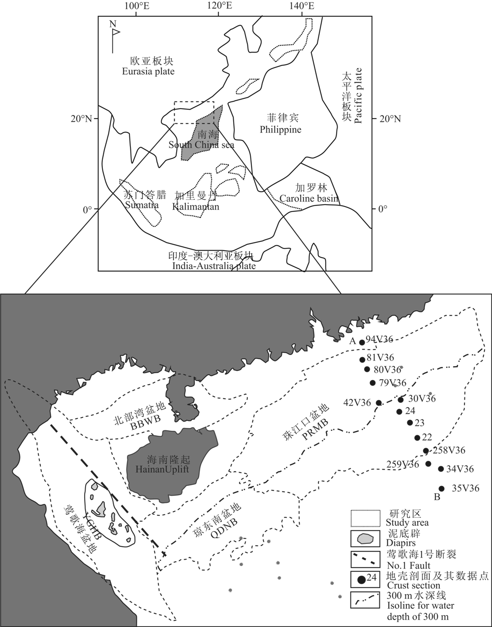 |
图1 南海北部大陆边缘区域地质概况 Fig.1 Regional geology of the northern South China Sea as a continental margin YGHB—Yinggehai Basin, BBWB—Beibuwan Basin, QDNB—Qiongdongnan Basin, PRMB—Pearl River Mouth Basin |
除莺歌海盆地的演化受红河断裂走滑作用影响外,其他盆地都属于由拉伸作用形成的裂谷型或离散边缘型盆地.这些盆地的形成演化整体上经历了裂陷期和裂后期两个大的演化阶段,期间有多幕拉张伸展,盆地具有明显的下断上坳双层结构(Ru et al., 1994; 龚再升, 2004) .结合区域动力学背景分析,盆地演化分为扩张前初始裂陷阶段、同扩张强烈裂陷阶段、扩张后缓慢沉降阶段和扩张后快速沉降阶段(解习农等, 2011) .盆地的沉积环境一方面受控于构造演化阶段,另一方面与不同陆缘盆地所处的大地构造位置与古地理有关.研究区发生了两次沉积环境突变,第一次发生在晚渐新世,从以陆相沉积为主变为滨浅海相沉积;第二次发生在中新世中晚期,由浅海相沉积向深海、半深海相沉积变化(Lüdmann and Wong, 1999; Xie et al., 2006)(图 2).
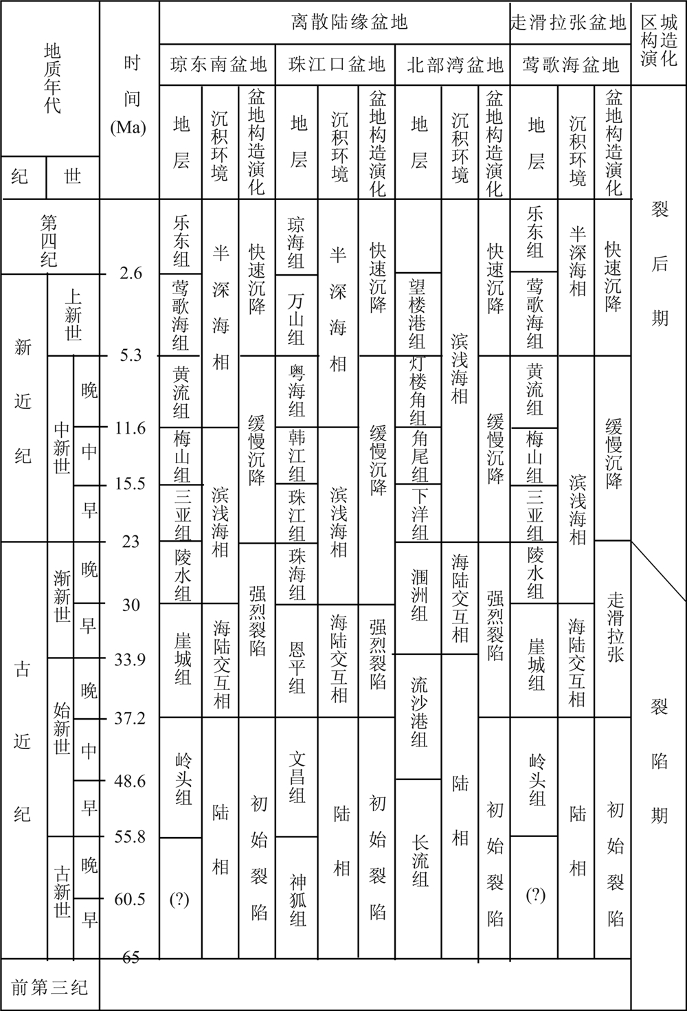 |
图2 南海北部大陆边缘盆地构造演化与沉积环境(据解习农等(2011)修改) Fig.2 Tectonic evolution and sedimentation of basins in the northern South China Sea (modified from Xie et al. (2011)) |
为了研究南海的起源、演化历史、大地构造属性及其形成的地球动力学背景,前人在大地热流测量方面做了大量工作,获得了大量钻井和海底探针地热数据(Anderson et al., 1978; Jessop et al., 1976; Nissen et al., 1995; Qian et al. , 1995; Ru et al., 1986; Shyu et al., 1998; Taylor et al., 1983; Watanable et al., 1977; Xia et al., 1995; 陈墨香等, 1991; 饶春涛和李平鲁, 1991).He等(2001a)对南海地区已发表的热流数据进行了系统收集和整理、分析,利用收集到的589个大地热流数据编制了南海大地热流图.Shi等(2003收集整理了南海地区热流数据592个,并进行了系统分析,研究了南海地区大地热流在平面上各构造单元的分布特征.本文在前人研究基础上,新增测试热导率数据148个,新增计算地温梯度数据65个,由此计算大地热流数据65个.
岩石热导率是岩石热物性中最主要的参数,是研究地壳和上地幔热结构、地球深部热状态的基础,也是大地热流测量的主要内容之一.本文采用德国TCS(Thermal Conductivity Scanning)自动扫描仪测试了莺歌海盆地、 北部湾盆地148个样品的热导率数据(表 1),设备的测量范围为0.2~25 W/(m·K). 综合前人研究成果(Yuan et al., 2009; 饶春涛等, 1991),得出研究区盆地整体热导率情况.研究区泥岩热导率0.94~2.85 W/(m·K), 砂岩热导率0.99~ 2.98 W/(m·K),灰岩热导率0.72~3.5 W/(m·K),基底岩石包括花岗岩、闪长岩、石英岩等热导率1.42~ 4.43 W/(m·K)(图 3右).可以看出,研究区同一岩性的热导率差异较大(图 3),因为虽然岩性相同,但由于埋深不同,固结程度与孔隙度不同,从而热导率也不同.由于泥岩的孔隙度与压实作用关系密切,随埋深增加,孔隙度一般呈指数衰减,泥岩热导率与深度相关性也更为明显(图 3a).砂岩和灰岩与地层埋深之间也具有一定的相关性,即随埋深增加,砂岩和灰岩的热导率总体上有增加的趋势,但离散性高 (图 3b, 3c),这是由于岩石热导率的高低除与压实程度、孔隙度有关外,还与岩石成分、结构有关.比如,砂岩石英含量越高,热导率则越高,长石含量越高,热导率则越低.研究区的基底岩石主要为变质岩与花岗岩,这些岩石结构上一般比沉积岩致密,压实系数小,孔隙度随深度变化小,因此,热导率与埋深之间不存在明显的相关性(图 3d).
| 表1 莺歌海盆地、北部湾盆地热导率数测试结果 Table 1 Newly measured thermal conductivity data |
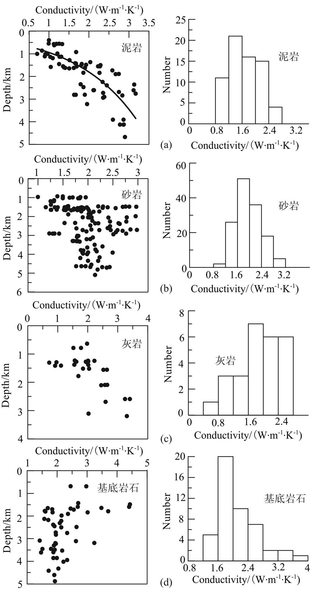 |
图3 研究区热导率图左为岩石热导率与深度的关系图,图右为对应岩石热导率直方图. Fig.3 Charts showing characteristics of thermal conductivity for rocks from four basins (YGHB, BBWB, QDNB and PRMB) in the northern of the South China Sea Left figures show the relationship between thermal conductivity and depth while right ones illustrate the value distribution of thermal conductivity for different kinds of rocks in histogram. |
由于南海大陆边缘盆地岩芯样品非常有限,并非有温度数据的钻井都可以测试其热导率.根据实测的大量岩芯样品,按照各地层岩性比例,采用加权平均的方法可计算盆地各地层的平均热导率,由此可建立盆地地层热导率柱(邱楠生等, 2004).本文仅测试了莺歌海盆地与北部湾盆地的岩芯热导率,现将这两个盆地的地层热导率柱展示于表 2.
| 表2 盆地地层热导率柱 Table 2 Average thermal conductivity of each formation of the PMRB and the YGHB |
要准确获得大地热流数据,使其能真实地反映区域热背景,除了要有可靠的热导率数据外,还必须要有可靠的地温梯度数据.本文利用比较可靠的井底稳定温度数据、地层压力测量时的温度数据、油层稳定温度数据、试油资料外推温度数据等较稳定的温度数据,根据线性回归的方法计算得到新的地温梯度数据(表 3).综合前人研究资料(Yuan et al., 2009)绘制了南海北部大陆边缘盆地地温等值线图,可见,地温梯度在平面上呈“准带状”分布,珠江口盆地、琼东南盆地深水区(300m水深以南)地温梯度值明显高于浅水区地温梯度(图 4).
| 表3 新增热流数据 Table 3 Newly acquired geothermal gradient and heat flow data |
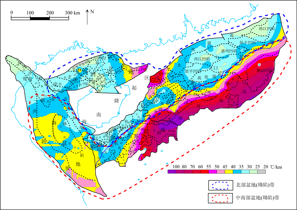 |
图4 北部大陆边缘盆地地温梯度等值线图 Fig.4 Contours of geothermal gradients in basins of the northern South China Sea |
大地热流是表征由地球内部向地表传输并在单位面积上散发的热量,它是地球内部的各种动力学过程的能量平衡在地表最直接的反映,在数值上,大地热流值等于地温梯度与地层热导率之积:

式中, q为大地热流(或称地表热流)值(mW/m2);k为热导率(W/(m·K)); 为地温梯度(℃/km); 负号表示热流方向与地温梯度方向相反.
从式(1)中可以看出大地热流数据质量取决于地温梯度和岩石热导率的测试精度.海上盆地的地温数据不同于陆盆,很少有系统的钻井测温数据.本文计算地温梯度的温度数据属于比较可靠的井底稳定温度数据、地层压力测量时的温度数据、油层稳定温度数据、试油资料外推温度数据等较稳定的温度数据.在计算大地热流时,尽可能采用钻井地温梯度温度乘以其对应深度段岩芯的热导率,如该钻孔或岩芯不全,则参考盆地地层平均热导率数据(表 2). 在Shi 等(2003)的基础上,收集了研究区2003年以来的新发表的热流数据 (李亚敏等, 2010; 徐行等, 2006),并结合本文65个新增计算热流数据(表 3,图 5),计算得出珠江口盆地、琼东南盆地、北部湾盆地、莺歌海盆地的平均热流值分别为68.7± 11 mW/m2、71.1±13 mW/m2、65.7±8.9 mW/m2、74.7±10 mW/m2; 绘制了中国南海北部大陆边缘盆地热流等值线图(图 6).为保证等值线边界热流的准确性,绘图时加入了周边大陆地表热流(Hu et al., 2000).从分布趋势上来看,大地热流与地温梯度基本一致,均体现出了由陆架区向陆坡区增加的趋势.
 |
图5 研究区大地热流数据点分布 Fig.5 Heat flow data scattered in the study area Red solid circles represent the data from previous research while the blue solid circles represent the data from this paper. |
值得注意的是,本文中的地温梯度、热流等值线图是基于所有收集到的相关数据而得来的,这些数据包括钻井数据、航测数据以及探针数据.而相关的平均值是由相对稳定的钻井数据计算而来.
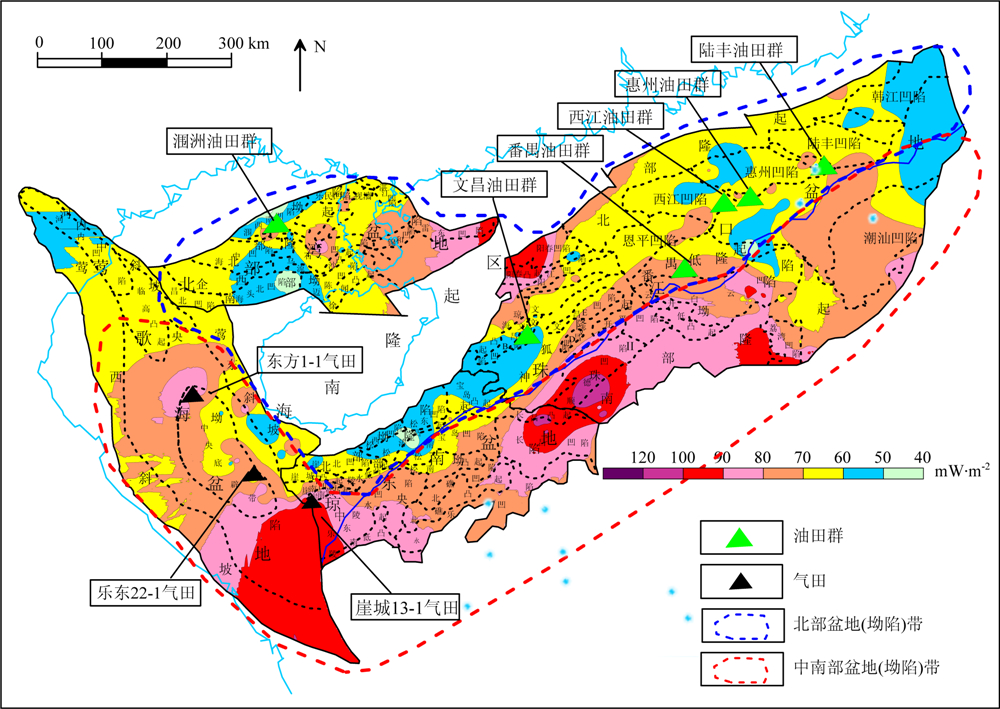 |
图6 南海北部大陆边缘盆地热流等值线及油气田分布图 Fig.6 Map showing the heat flow characteristics and oil-gas field distribution in the northern South China Sea |
研究区盆地的地温梯度(平均37.1±6.3 ℃/km)与热流值(平均72.6±15.6 mW/m2) 均较高.地温梯 度值远高于中国中西部地区的鄂尔多斯(24.4 ℃/km) (Yuan et al., 2007)、四川(22.8 ℃/km)(徐明等, 2011)、塔里木(20 ℃/km)(王良书等, 2003)和准噶 尔(21.2~22.6 ℃/km)(王社教等, 2000;邱楠生等, 2001)等克拉通盆地的地温梯度,与中国近海其他盆地相比,其地温梯度比东海(32.7 ℃/km)(Yang et al., 2004)和南黄海(28.6 ℃/km)(杨树春等, 2003)都高.热流值比中国大陆地区大地热流平均值(63±24.2 mW/m2)(Hu et al., 2000)高10 mW/m2以上,也高于东海和南黄海盆地的平均热流值(Yang et al., 2004; 杨树春等, 2003).可见,南海北部大陆边缘盆地属于典型“热盆”(Wang, 1996).
盆地现今地温场受诸多因素的影响,如构造运动活动性强弱、最后一次热事件发生的时间、岩石圈伸展拉张程度、地壳厚度、高导层埋深等(袁玉松等, 2006).南海北部大陆边缘是晚白垩世以来多期幕式张裂及随后热沉降的结果(He et al., 2001b; Ru et al., 1986),多期拉张导致地壳减薄并产生大幅度构造沉降.南海北部地壳结构研究从20世纪70年代开始,经历了声纳浮标、双船扩展排列地震(EPS)和海底地震仪探测(OBS或OBH)几个阶段(丘学林等, 2003).研究表明南海北部陆缘地壳由陆地向南海中央海盆方向减薄(Nissen et al., 1995; Pin et al., 2001; Qiu et al., 2001; 姚伯初, 1998)(图 7). 南海北部大陆边缘的热流分布具有“带状”特征,随地壳厚度向南减薄而逐渐增高.研究区内岩浆活动发育,早第三纪早期的岩浆活动以中酸性为主,早第三纪晚期转化为以碱性玄武岩和拉斑玄武岩为主的裂陷盆地火山序列,10 Ma以后珠江口地区断裂活动加剧,源于深部碱性玄武岩和拉斑玄武岩有较 大规模喷发活动(Yan et al., 2006; 李思田等, 1998; 邹和平等, 1995). 这些岩浆活动可能是引起局部热流高值异常的原因,如珠江口盆地顺德凹陷的高值异常与始新世—渐新世的基性岩侵入和喷发位置相吻合.除岩浆活动以外,断裂活动也可能是导致局部热流高值异常的原因,如阳江凹陷的高值异常可能与珠三坳陷的北部边界断裂活动有关(饶春涛等, 1991),莺歌海盆地与琼东南盆地西部因受莺歌海1号断裂走滑影响而呈现高热流值.
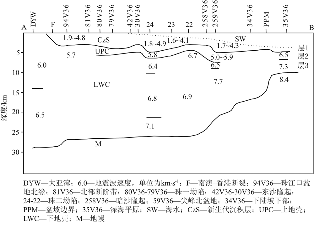 |
图7 南海北部陆缘地壳结构断面图(据姚伯初(1998)修改)剖面AB的位置见图 1. Fig.7 Cross section of crust in the northern South China Sea (modified from Yao (1998))Location of the section AB is shown in Fig.1. |
南海北部大陆边缘自北向南分布有近东西向延展的两个盆地(坳陷)带,即北部盆地(坳陷)带与中南部盆地(坳陷)带.北部盆地(坳陷)带为北部湾盆地—珠江口盆地北部坳陷;中南部盆地(坳陷)带包 括莺歌海盆地—琼东南盆地—珠江口盆地珠Ⅱ坳陷、潮汕坳陷等(张功成等, 2010)(图 5).
北部盆地(坳陷)带具有与中国东部古近系陆相断陷盆地相似的典型断坳双层盆地结构,普遍充填了古近系陆相断陷沉积和新近系海相坳陷沉积,且断陷裂谷期的陆相充填沉积规模尤其是厚度,一般大于海相坳陷沉积.由于该区地壳厚度大,大地热流值相对较低(平均65.7±9.4 mW/m2),烃源岩有机质成熟度亦较低,故主要以生油为主.北部大陆边缘目前勘探发现的油田群均位于此带,如陆丰油田群、惠州油田群、西江油田群、番禺油田群、文昌油田群、涠洲油田群.而中南部盆地(坳陷)带由于地壳厚度减薄,大地热流值高(平均87.1±16 mW/m2),烃源岩有机质成熟度高,以产气为主.在该带发现的主要是气田,如崖城13-1气田,东方1-1气田,乐东22-1气田(图 6)(张功成等, 2010).
地热条件是油气形成、演化最基本的控制条件之一,热流高对油气有利的说法并不准确与严格,理想的条件是由热流决定的地温(或地温梯度)与有利生油岩系空间位置配置的适当.一般地说,当生油岩埋藏深度(现今的或历史的)较大时,热流过高将使生油母质过成熟、少油而相对多气,反之又将有相当一部分生油岩不成熟从而既贫油也贫气.如生油岩系埋深较浅,热流相对高则是油气富集的有利条件,因此,热流研究对油气总体评价有着重大的现实意义(汪辑安, 1992).本文通过分析南海北部大陆边缘盆地的地热分布特征以及油气分布富集情况,发现两者具有很好的相关性,这种相关性对预测油气远景区以及油气勘探具有一定的指导作用,但这种相关性目前只停留在定性阶段,更深入的研究还需要下一步工作.
通过统计研究区现有地热数据,南海北部大陆边缘盆地的平均地温梯度为37.1±6.3 ℃/km,平均热流值为72.6 ±15.6 mW/m2,属于典型的“热盆”.热流值分布受区域构造背景控制,由北部盆地(坳陷)带向中南部盆地(坳陷)带增高,这种增高趋势与北部地壳由陆架向陆坡区减薄的趋势相对应;局部热流高值异常可能由岩浆、断裂等活动造成.
勘探成果表明,南海北部大陆边缘油气富集与大地热流分布存在良好的相关性.油田多分布在北部盆地(坳陷)带,而气田多分布在中南部盆地(坳陷)带,呈现出“北油南气”的分布特点,与热流值“带状”分布耦合.
致谢本工作研究使用的地温数据由中海油研究总院提供,感谢中海石油(中国)有限公司湛江分公司在热导率样品采样及测试过程中提供的帮助.
| [1] | Anderson R N, Langseth M G, Hayes D E, et al. 1978. Heat flow, thermal conductivity, geothermal gradient. //Hayes D E eds. Geophysical Atlas of the East and Southeast Asian Seas. Geological Society of America, Boulder, CO. |
| [2] | Briais A, Patriat P, Tapponnier P. 1993. Updated interpretation of magnetic anomalies and seafloor spreading stages in the South China Sea: implications for the Tertiary tectonics of Southeast Asia. Journal of Geophysical Research B: Solid Earth, 98(B4): 6299-6328, doi: 10.1029/92jb02280. |
| [3] | Chen M X, Xia S G, Yang S Z. 1991. Local geothermal anomalies and their formation mechanisms on Leizhou peninsula, South China. Scientia Geologica Sinica (in Chinese), 26(4): 369-383. |
| [4] | Gong Z S, Li S T, Xie T J, et al. 1997. Continental Margin Basin Analysis and Hydrocarbon Accumulation of the Northern South China Sea (in Chinese). Beijing: Science Press. |
| [5] | Gong Z S. 2004. Neotectonics and petroleum accumulation in offshore Chinese basins. Earth Science-Journal of China University of Geosciences (in Chinese), 29(5): 513-517, doi: 10.3321/j.issn:0253-9985.2004.02.003. |
| [6] | He J X, Liu H L, Yao Y J, et al. 2008. China Sea Marginal Basin Geology and Resources of Oil and Gas Prospects (in Chinese). Beijing: Petroleum Industry Press. |
| [7] | He L, Wang K, Xiong L, et al. 2001a. Heat flow and thermal history of the South China Sea. Physics of the Earth Planetary Interiors,126(3-4): 211-220,doi: 10.1016/s0031-9201(01)00256-4. |
| [8] | He L J, Xiong L P, Wang J Y, et al. 2001b. Tectono-thermal modeling of the Yinggehai Basin, South China Sea. Science in China Series D: Earth Sciences, 44(1): 7-13, doi: 10.1007/bf02906880. |
| [9] | Hu S, He L, Wang J. 2000. Heat flow in the continental area of China: a new data set. Earth and Planetary Science Letters,179(2): 407-419, doi: 10.1016/s0012-821x (00)00126-6. |
| [10] | Jessop A M, Hobart M A, Sclater J G. 1976. The world heat-flow data collection-1975. Geothermal Series Number 5. Canada: Earth Physics Branch, 5: 125. |
| [11] | Jin Q H. 2006. Petroleum in deep water is the major prospecting hotspot nowadays. Scientific Chinese (in Chinese), 18(11): 18-20, doi: 10.3969/j.issn.1005-3573.2006.11.005. |
| [12] | Klemme H D. 1972. Geothermal gradients. Part 2. Heat influences size of oil giants. Oil and Gas Journal, 70(30): 76-78. |
| [13] | Li S T, Lin C S, Zhang Q M, et al. 1998. The dynamics process of episodic rifting and the tectonic events since 10Ma of continental margin basin of northern South China Sea. Chinese Science Bulletin (in Chinese), 43(8): 797-810. |
| [14] | Li Y M, Luo X H, Xu X, et al. 2010. Seafloor in-situ heat flow measurements in the deep—water area of the northern slope, South China Sea. Chinese Journal of Geophysics (in Chinese), 53(9): 2161-217, doi: 10.1002/cjg2.1547. |
| [15] | Lüdmann T, Wong H K. 1999. Neotectonic regime on the passive continental margin of the northern South China Sea. Tectonophysics, 311(1-4): 113-138, doi: 10.1016/s0040-1951(99)00155-9. |
| [16] | Nissen S S, Hayes D E, Bochu Y, et al. 1995. Gravity, heat flow, and seismic constraints on the processes of crustal extension: Northern margin of the South China Sea. Journal of Geophysical Research, 100(B11): 22447-22483, doi: 10.1029/95jb01868. |
| [17] | Qian Y P, Niu X P, Yao B C, et al. 1995. Geothermal pattern beneath the continental margin in the northern part of the South China Sea. CCOP/TB, 25: 89-104. |
| [18] | Qiu N S, Hu S B, He L J, et al. 2004. Principles and Applications on Thermal Regime of Sedimentary Basins. Beijing: Petroleum Industry Press. |
| [19] | Qiu N S, Wang X L, Yang H B, et al. 2001. The characteristics of temperature distribution in the Junggar basin. Scientia Geologica Sinica (in Chinese), 36(3): 350-358, doi:10.3321/j.issn:0563-5020.2001.03.010. |
| [20] | Qiu X L, Shi X B, Yan P, et al. 2003. New progresses in study and sounding seismic exploration on crustal structure in northern South China Sea. Progress in Natural Science (in Chinese), 13(3): 9-14, doi:10.3321/j.issn:1002-008X.2003.03.002. |
| [21] | Qiu X, Ye S, Wu S, et al. 2001. Crustal structure across the Xisha Trough, northwestern South China Sea. Tectonophysics, 341(1-4): 179-193, doi: 10.1016/s0040-1951(01)00222-0. |
| [22] | Rao C T, Li P L. 1991. Study of heat flow in Pearl River Mouth Basin. China Offshore Oil and Gas (Geology) (in Chinese), 5(6): 7-18. |
| [23] | Ru K, Pigott J D. 1986. Episodic rifting ad subsidence in the South China Sea. AAPG Bulletin, 70(9): 1136-1155, doi: 10.1306/94886a8d-1704-11d7-8645000102c1865d. |
| [24] | Ru K, Zhou D, Chen H Z. 1994. Basin evolution and hydrocarbon potential of the northern South China Sea. Zhou D, Liang Y B, Zeng C K ed. Oceanology of China Seas, Volume 2. Dordrecht; Boston; London: Kluwer Academic Publishers, 361-372, doi: 10.1007/978-94-011-0862-1_35. |
| [25] | Shi X, Qiu X, Xia K, et al. 2003. Characteristics of surface heat flow in the South China Sea. Journal of Asian Earth Sciences, 22(3): 265-277, doi: 10.1016/s1367-9120(03)00059-2. |
| [26] | Shyu C T, Hsu S K, Liu C S. 1998. Heat flows off southwest Taiwan: Measurements over mud diapirs and estimated from bottom simulating reflectors. Terrestrial Atmospheric and Oceanic Sciences, 9(4): 795-812. |
| [27] | Taylor B, Hayes D E. 1983. Origin and history of the South China basin. //Hayes D E ed. The Tectonics and Geological Evolution of Southeast Asia Seas and Islands, Part 2. Geophysics Monographs Series, 27th AGU, Washington, DC, 23-56, doi: 10.1029/gm027p0023. |
| [28] | Tissot B P, Durand B, Espitali J, et al. 1974. Influence of nature and diagenesis of organic-matter in formation of petroleum. AAPG Bulletin, 58(3): 499-506, doi: 10.1306/83d91425-16c7-11d7-8645000102c1865d. |
| [29] | Tissot B P, Pelet R, Ungerer P. 1987. Thermal history of sedimentary basins, maturation indexes, and kinetics of oil and gas generation. AAPG Bulletin, 71(12): 1445-1466, doi: 10.1306/703c80e7-1707-11d7-8645000102c1865d. |
| [30] | Wang J A. 1992. Geothermal studies on oil-gas resources. Advance in Earth Sciences (in Chinese), 7(3): 15-19. |
| [31] | Wang J Y. 1996. Geothermics in China. Beijing: Seismological Press. |
| [32] | Wang L S, Li C, Liu S W, et al. 2003. Geotemperature gradient distribution of Kuqa foreland basin, north of Tarim, China. Chinese Journal of Geophysics (in Chinese), 46(3): 403-407, doi: 10.1002/cjg2.3375. |
| [33] | Wang S J, Hu S B, Wang J Y. 2000. The characteristics of heat flow and geothermal fields in Junggar basin. a href="http://onlinelibrary.wiley.com/doi/10.1002/cjg2.98/abstract" target=_blank> Chinese Journal of Geophysics (in Chinese), 43(6): 771-779, doi: 10.1002/cjg2.98.< |
| [34] | Watanable T, Langseth M G, Anderson R N. 1977. Heat flow in back-arc basins of the western Pacific. //Talwani M, Pitman W C ed. Island Arcs, Deep Sea Trenches and Back-Arc Basins. Washington D C: AGU, 137-167, doi: 10.1029/me001p0137. |
| [35] | Xia K Y, Xia S G, Chen Z R, et al. 1995. Geothermal characteristics of the South China Sea. //Gupta M L, Yamano M ed. Terrestrial Heat Flow and Geothermal Energy in Asia. New Delhi: Oxford & IBH Publishing, 113-128. |
| [36] | Xie M Q. 1981. The controlling role of terrestrial heat flow in the genesis of petroleum. Acta Petrolei Sinica (in Chinese), 2(1): 41-48, doi: 10.7623/syxb198101005. |
| [37] | Xie X, Müller R D, Li S, et al. 2006. Origin of anomalous subsidence along the Northern South China Sea margin and its relationship to dynamic topography. Marine and Petroleum Geology, 23(7): 745-765, doi: 10.1016/j.marpetgeo.2006.03.004. |
| [38] | Xie X N, Zhang C, Ren J Y, et al. 2011. Effects of distinct tectonic evolutions on hydrocarbon accumulation in northern and southern continental marginal basins of South China Sea. Chinese Journal of Geophysics (in Chinese), 54(12): 3280-3291, doi: 10.1002/cjg2.1687. |
| [39] | Xu M, Zhu C Q, Tian Y T, et al. 2011. Borehole temperature logging and characteristics of subsurface temperature in the Sichuan Basin. Chinese Journal of Geophysics (in Chinese), 54(4): 1052-1060, doi: 10.1002/cjg2.1604. |
| [40] | Xu X, Shi X B, Luo X H, et al. 2006. Heat flow measurements in the Xisha Trough of the South China Sea. Marine Geology and Quaternary Geology (in Chinese), 26(4): 51-58. |
| [41] | Yang S C, Hu S B, Cai D S, et al. 2003. Geothermal characteristics and tectonothermal evolution of the southern area of South Yellow Sea. Chinese Science Bulletin (in Chinese), 48(14): 1564-1569, doi: 10.3321/j.issn:0023-074X.2003.14.017. |
| [42] | Yang S C, Hu S B, Cai D S, et al. 2004. Present-day heat flow, thermal history and tectonic subsidence of the East China Sea Basin. Marine and Petroleum Geology, 21(9): 1095-1105, doi: 10.1016/j.marpetgeo.2004.05.007. |
| [43] | Yan P, Deng H, Liu H, et al. 2006. The temporal and spatial distribution of volcanism in the South China Sea region. Journal of Asian Earth Sciences, 27(5): 647-659, doi: 10.1016/j.jseaes.2005.06.005. |
| [44] | Yan P, Zhou D, Liu Z S. 2001. A crustal structure profile across the northern continental margin of the South China Sea. Tectonophysics, 338(1): 1-21, doi: 10.1016/s0040-1951(01)00062-2. |
| [45] | Yao B C. 1998. Crust structure of the northern margin of the South China Sea and its tectonic significance. Marine Geology and Quaternary Geology (in Chinese), 18(2): 1-16. |
| [46] | Yuan Y, Hu S, Wang H, et al. 2007. Meso-Cenozoic tectonothermal evolution of Ordos basin, central China: Insights from newly acquired vitrinite reflectance data and a revision of existing paleothermal indicator data. Journal of Geodynamics, 44(1-2): 33-46, doi: 10.1016/j.jog.2006.12.002. |
| [47] | Yuan Y S, Ma Y S, Hu S B, et al. 2006. Present geothermal characteristics in South China. Chinese Journal of Geophysics (in Chinese), 49(4): 1118-1126, doi: 10.1002/cjg2.922. |
| [48] | Yuan Y, Zhu W L, Mi L J, et al. 2009. "Uniform geothermal gradient" and heat flow in the Qiongdongnan and Pearl River Mouth Basins of the South China Sea. Marine and Petroleum Geology, 26(7): 1152-1162, doi:10.1016/j.marpetgeo.2008.08.008. |
| [49] | Zhang G C, Mi L J, Wu S G, et al. 2007. Deepwater area—the new prospecting targets of northern continental margin of South China Sea. Acta Petrolei Sinica (in Chinese), 28(2): 15-21, doi: 10.3321/j.issn:0253-2697.2007.02.003. |
| [50] | Zhang G C, Zhu W L, Mi L J, et al. 2010. The theory of hydrocarbon genernation controlled by source rock and heat from circle distribution of outside-oil fields and inside-gas fields in South China Sea. Acta Sedimentologica Sinica (in Chinese), 28(5): 987-1005. |
| [51] | Zou H P, Li P L, Rao C T. 1995. Geochemistry of Cenozoic volcanic rocks in Zhujiangkou Basin and its geodynamic significance. Geochimica (in Chinese), 24 (Suppl.): 33-45. |
| [1] | 陈墨香, 夏斯高, 杨淑贞. 1991. 雷州半岛局部地热异常及其形成机制. 地质科学, 26(4): 369-383. |
| [2] | 龚再升, 李思田, 谢泰俊等. 1997. 南海北部大陆边缘盆地分析与油气聚集. 北京: 科学出版社. |
| [3] | 龚再升. 2004. 中国近海含油气盆地新构造运动与油气成藏. 地球科学, 29(5): 513-517, doi: 10.3321/j.issn:0253-9985.2004.02.003. |
| [4] | 何家雄, 刘海龄, 姚永坚等. 2008. 南海北部边缘盆地油气地质及资源前景. 北京: 石油工业出版社. |
| [5] | 金庆焕. 2006. 深水油气是当今海洋油气勘探的主要热点. 科学中国人, 18(11): 18-20, doi: 10.3969/j.issn.1005-3573.2006.11.005. |
| [6] | 李思田, 林畅松, 张启明等. 1998. 南海北部大陆边缘盆地幕式裂陷的动力过程及10 Ma以来的构造事件. 科学通报, 43(8): 797-810. |
| [7] | 李亚敏, 罗贤虎, 徐行等. 2010. 南海北部陆坡深水区的海底原位热流测量. 地球物理学报, 53(9): 2161-2170, doi: 10.1002/cjg2.1547. |
| [8] | 邱楠生, 胡圣标, 何丽娟等. 2004. 沉积盆地热体制研究的理论与应用. 北京: 石油工业出版社. |
| [9] | 邱楠生, 王绪龙, 杨海波等. 2001. 准噶尔盆地地温分布特征. 地质科学, 36(3): 350-358, doi:10.3321/j.issn:0563-5020.2001.03.010. |
| [10] | 丘学林, 施小斌, 阎贫等. 2003. 南海北部地壳结构的深地震探测和研究新进展. 自然科学进展, 13(3): 9-14, doi:10.3321/j.issn:1002-008X.2003.03.002. |
| [11] | 饶春涛, 李平鲁. 1991. 珠江口盆地热流研究. 中国海上油气(地质), 5(6): 7-18. |
| [12] | 汪辑安. 1992. 油气地热研究. 地球科学进展, 7(3): 15-19. |
| [13] | 王良书, 李成, 刘绍文等. 2003. 塔里木盆地北缘库车前陆盆地地温梯度分布特征. 地球物理学报, 46(3): 403-407, doi: 10.1002/cjg2.3375. |
| [14] | 王社教, 胡圣标, 汪集旸. 2000. 准噶尔盆地热流及地温场特征. 地球物理学报, 43(6): 771-779, doi: 10.1002/cjg2.98. |
| [15] | 谢鸣谦. 1981. 地热流对石油生成的控制作用. 石油学报, 2(1): 41-48, doi: 10.7623/syxb198101005. |
| [16] | 解习农, 张成, 任建业等. 2011. 南海南北大陆边缘盆地构造演化差异性对油气成藏条件控制. 地球物理学报, 54(12): 3280-3291, doi: 10.1002/cjg2.1687. |
| [17] | 徐明, 朱传庆, 田云涛等. 2011. 四川盆地钻孔温度测量及现今地热特征. 地球物理学报, 54(4): 1052-1060, doi: 10.1002/cjg2.1604. |
| [18] | 徐行, 施小斌, 罗贤虎等. 2006. 南海西沙海槽地区的海底热流测量. 海洋地质与第四纪地质, 26(4): 51-58. |
| [19] | 杨树春, 胡圣标, 蔡东升等. 2003. 南黄海南部盆地地温场特征及热-构造演化. 科学通报, 48(14): 1564-1569, doi: 10.3321/j.issn:0023-074X.2003.14.017. |
| [20] | 姚伯初. 1998. 南海北部陆缘的地壳结构及构造意义. 海洋地质与第四纪地质, 18(2): 1-16. |
| [21] | 袁玉松, 马永生, 胡圣标等. 2006. 中国南方现今地热特征. 地球物理学报, 49(4): 1118-1126, doi: 10.1002/cjg2.922. |
| [22] | 张功成, 米立军, 吴时国等. 2007. 深水区—南海北部大陆边缘盆地油气勘探新领域. 石油学报, 28(2): 15-21, doi: 10.3321/j.issn:0253-2697.2007.02.003. |
| [23] | 张功成, 朱伟林, 米立军等. 2010. "源热共控论": 来自南海海域油气田 "外油内气" 环带有序分布的新认识. 沉积学报, 28(5): 987-1005. |
| [24] | 邹和平, 李平鲁, 饶春涛. 1995. 珠江口盆地新生代火山岩地球化学特征及其动力学意义. 地球化学, 24(增刊): 33-45. |
 2014, Vol. 57


