2. 中国科学院遥感与数字地球研究所, 北京 100101;
3. 中国科学院测量与地球物理研究所大地测量与地球动力学国家重点实验室, 武汉 430077;
4. 国土资源部青岛海洋地质研究所, 青岛 266071
2. Institute of Remote Sensing and Digital Earth, Chinese Academy of Sciences, Beijing 100101, China;
3. State Key Laboratory of Geodesy and Earth's Dynamics, Institute of Geodesy and Geophysics, Chinese Academy of Sciences, Wuhan 430077, China;
4. Qingdao Institute of Marine Geology, Ministry of Land & Resources of China, Qingdao 266071, China
中国海陆莫霍面及深部地壳结构特征研究是东亚地区宏观构造格架和动力学研究中的重点内容之一.近年来,有关地壳厚度分布的研究成果不断发表,获得了许多重要结果和新的认识(Meissner et al., 1987;Chulick and Mooney, 2002;Grad et al., 2009;Molinari et al., 2012).中国大陆及海域位于欧亚、印度与太平洋三大板块的交汇处,是东亚地球动力学研究的核心地区,为此,中国海陆莫霍面深度分布特征已有不少学者编制了各种图件(刘光鼎, 1992,1993;曾融生等,1995; Li and Mooney, 1998; 滕吉文等,2002;高星等,2005;Li et al., 2006;黄建平等,2006;秦静欣等,2011).刘光鼎等(1992,1993)首次将中国海、陆置于统一构造演化体系中进行研究编绘了1 : 1000万的莫霍面深度分布图.曾融生等(1995)利用90年代以前的地震测深结果,编制了中国大陆莫霍面深度图.Li和Mooney(1998)以及Li 等(2006)根据1958年以来约90条深地震探测剖面绘制了中国大陆地壳结构图.滕吉文等(2002)对东亚大陆及周边海域莫霍面深度分布开展了研究并编绘了1 : 2500万的地壳厚度图.这些工作为我国地壳深部结构的研究打下了坚实的基础.但由于这些研究大多局限在中国大陆内部或向海域延伸有限,对于探索中国大陆宏观构造格架的延伸以及海陆相互作用关系等问题存在一定的局限.因此,本文在近年来一系列研究成果的基础上,聚焦欧亚板块、太平洋板块以及印度洋板块之间的相互作用及其在中国大陆与海域所引发的构造效应为重点,以地震测深等资料为约束信息,根据重力数据,通过分区计算,反演了中国海陆莫霍面深度.分析了中国海陆莫霍面深度分布与梯度带特征.并选取阿尔泰—巴士海峡典型剖面进行了重、震反演,建立了密度结构,讨论典型地区的莫霍面深度,深部地壳结构特征. 2 数据与研究方法 2.1 数据来源
研究区范围为0°—55°N,(71.5°E,40°N)—(135°E,40°N),采用兰伯特投影,大地基准面: WGS84,原点经纬度:105°E,0°,标准纬度:15°N,40°N. 研究中用于反演莫霍面深度的原始重力数据分别为:中国大陆地区重力数据来自中国地质调查局《全 国区域重力数据库》,其精度为±2.0×10⁻⁵m·s-2,比例尺为1 : 200万;研究区其他邻国陆地区的网格化重力数据来自中国地质调查局发展研究中心收集的Leeds大学东南亚重力项目数据库,数据网格密度为5′×5′1);海域采用美国Scripps研究所发布的全球卫星测高重力数据(Sandwell and Smith, 2009),经纬度网格2′×2′,数据精度(±4~6)×10-5m/s2 .
1)张明华,乔计花.2013.中国海及邻域布格重力异常图(项目报告).中国地质调查局发展研究中心.
2.2 研究方法
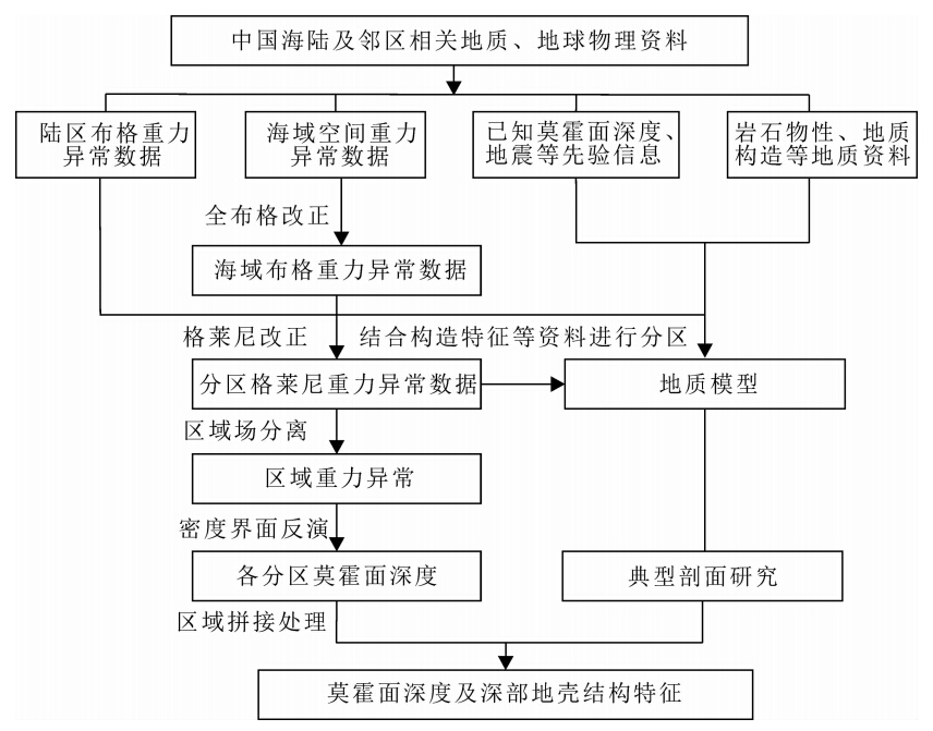
研究中以“区域约束局部、深层制约浅层”为指导思想,遵循“一种指导、两个环节、三项结合、多次反馈”的综合地球物理方法原则(刘光鼎和陈洁,2005; 刘光鼎,2007).在深地震探测结果的约束下,重点依据重力资料,分区反演了中国海陆莫霍面深度,结合典型剖面拟合反演及其解释,分析中国海陆莫霍面深度及深部地壳结构特征.研究技术路线如图 1所示.
 |
图 1 研究技术路线图 Fig. 1 Flow chart of technical approaches |
研究区范围较大,从大陆到大洋,地形起伏剧烈,跨越了多个构造单元,构造复杂,若整个研究区均采用单一的反演方法和相同的反演系数,往往顾此失彼,很难获得最佳的反演效果.因此,在莫霍面深度反演时,根据重力异常特征和构造特征,对研究区进行了分区,将陆区分为10个分区,海区分为6个分区(图 2),并对各分区进行了重力场分离、界面反演方法和相应的反演参数优选.
 |
图 2 莫霍面深度反演分区及已知控制点位置图 L1:哈萨克斯坦—中国西北部分区; L2:贝加尔湖—蒙古高原分区; L3:中国东北—库页岛分区; L4:中国西北部分区; L5:青藏高原分 区; L6:鄂尔多斯—汾渭裂谷分区; L7: 四川盆地—云贵高原分区; L8:中国东部分区; L9:印度次大陆分区; L10:中南半岛及其邻域分区. S1:渤海—黄海分区;S2:黄海—东海分区;S3:南海分区;S4:菲律宾海分区;S5:安达曼海—南沙群岛分区;S6:印度洋分区. Fig. 2 Positions of controlling points of known Moho depth and sub-regions for Moho inversion L1: Kazakhstan—Northwest China; L2: Lake Baikal—Mongolian Plateau; L3: Northeast China—Sakhalin Isl and ; L4: Northwest China; L5: Tibetan Plateau; L6:Ordos—Fenwei rift; L7:Sichuan Basin—Yungui Plateau; L8:East China; L9:India sub-continent; L10: Indochina and neighboring area. S1: Bohai Sea—Yellow Sea; S2: Yellow Sea—East China Sea; S3: South China Sea; S4:Philippine Sea; S5: Andaman Sea—Nansha Isl and s; S6: Indian Ocean. |
根据各分区地形、构造等特征及已知控制点信息,进行各种场分离方法结果的功率谱计算(李成立等,1998),界面反演方法结果和已知控制点的偏差计算分析,选择适合该区的重力场分离、界面反演方法和相应的反演参数.重力场分离方法的优选结果:正则化滤波法(管志宁和安玉林,1991)(L3、L6、L7、S3、S4、S6分区);补偿圆滑滤波法(侯重初,1981)(L1、L2、L8、L9、S1、S2分区);小波分析法(杨文采等,2001;徐亚和郝天珧,2004)(L4、L5、L10、S5分区).不同的界面反演方法适用性不同,在控制点信息较多的分区选择带控制点的三维界面反演法(秦静欣等,2011),而缺少甚至没有相应约束信息的区域选择自适应模拟退火(姚姚,1995)或Parker界面反演法(Parker,1973;Oldenburg,1974).莫霍面深度反演方法优选结果:带控制点的三维界面反演法(L1、L3—L8、S1—S3分区);Parker界面反演法(L2、L10、S4—S6分区);自适应模拟退火界面反演法(L9分区).各分区反演结果利用Geosoft软件的混合法或缝合法网格拼接后得到中国海陆莫霍面深度(图 3).
 |
图 3 中国海陆莫霍面深度、梯级带及特征分区图(黑色粗实线为典型剖面AA′位置) Fig. 3 Moho depth contours,gravity gradient belts and sub-regions(Black thick solid line is the location of typical profile AA′) |
为了提高重力异常反演莫霍面深度的精确度,减少反演的多解性,研究中收集、整理了研究区人工地震测深、地学断面、海底地震仪测深等各种实测剖面共120条(图 2)(王椿镛等,1995;胥颐等,1996;Qiu et al., 2001;Yan,et al.,2001;高锐等,2002; 刘福田等,2003;陈俊湘和陈景亮,2003;王有学等,2004,2005;Mcintosh, et al.,2005;Zhang,et al.,2009;秦静欣,2012),得到了以人工地震等实测剖面数据为主的控制点数据8948个作为反演先验信息.其中精度高的剖面(人工地震测深、海陆联测剖面、OBS/OBH剖面、综合探测剖面、双船折射)71条,占120条剖面的59.17%,数据点4602个;精度较高的剖面(天然地震、声呐浮标)10条,占8.33%,数据点638个;精度中等的剖面(MT剖面、重磁剖面)17条,占14.17%,数据点1895个;精度低的剖面(地震层析成像)22条,占18.33%,数据点1813个. 3.2 莫霍面深度特征
以地壳性质为基础,结合莫霍面深度分布特征、重力异常特征以及块体差异等,本文共划分了12个莫霍面深度梯级带,6个一级分区和24个二级分区(图 3).其中一级分区主要以地壳性质的不同为基础将研究区划分为增厚型地壳区、正常型地壳区、减薄型地壳区、沟-弧-盆体系地壳异常区、过渡型地壳区和大洋型地壳区;二级分区更侧重于莫霍面深度分布特征,并结合重力异常及块体构造差异等(图 3、表 1和表 2).
| 表 1 中国海陆莫霍面深度梯级带及其特征 Table 1 Features of Moho depth gradient belts in the l and and seas of China and adjacent areas |
| 表 2 中国海陆莫霍面深度分区及其特征 Table 2 Regional division of Moho depths in the l and and seas of China and adjacent areas |
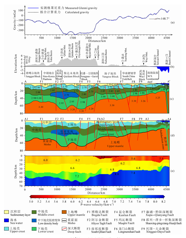
为了认识研究区深部结构特征并对莫霍面深度反演提供约束,本文选取了一条典型剖面进行重、震反演(剖面位置见图 3中黑色粗实线),根据格莱尼重力异常进行2.5D剖面反演,结合层析成像结果,分析其莫霍面深度及深部结构特征.阿尔泰—巴士海峡剖面(以下简称AA′剖面)总长4604 km,整体上呈NW—SE走向.起始点A位于阿尔泰山,终点A′位于巴士海峡的加拉鄢岛(属于巴布延群岛),横穿了阿尔泰山、博格达山、祁连山、阿尼玛卿山、巴颜喀拉山、龙门山、雪峰山和武夷山等山脉,经过的盆地有准噶尔盆地、吐哈盆地、柴达木盆地和四川盆地,主要的构造单元有准噶尔地块、中朝地台、祁连地块、柴达木地块、松潘—甘孜地块、扬子地块、华南褶皱带、武夷地块和南海陆架.剖面四个角点的地理坐标如表 3所示.
| 表 3 剖面各角点位置 Table 3 Locations of profile corners |
反演初始模型建立主要参考前人沿台湾—阿尔泰地学断面进行的地壳纵波、面波速度结构,热结构和重磁解释等研究(王懋基,1994;胡圣标等,1994;蔡学林等,2004;王有学等, 2004,2005).岩石密度参数收集并整理前人研究成果统计见表 4(部分是由地震波速度转换的密度参数).通过人机交互二度半剖面重力拟合反演,得到了剖面的密度结构及其地质解释,反演均方差为3.24 mGal(图 4).
| 表 4 剖面反演密度参数选择 Table 4 Densities for profile inversion |
 |
图 4 AA′剖面反演密度结构及其地质解释 (a)剖面重力异常;(b)剖面地形;(c)密度结构;(d)地质解释;(e)层析成像P波速度结构. Fig. 4 Density structure from inversion and geological interpretation of profile AA′ (a)Gravity Anomalies;(b)Topography;(c)Density structure;(d)Geological interpretation;(e)P-wave velocity structure of tomography. |
剖面阿尔泰山—龙门山段(A1—A2):阿尔泰山南缘莫霍面深度为56 km,准噶尔盆地的地壳厚度最薄为45 km.准噶尔盆地和吐哈盆地均有较厚的沉积层,其中吐哈盆地最厚约8 km.下地壳的平均厚度约20 km,阿尔泰山地区下地壳厚达30 km,与准噶尔盆地薄的下地壳(约15 km厚)形成明显对比.祁连山—龙门山的莫霍面深度呈“W”型起伏,且起伏较大,中朝地台莫霍面深度约为50 km,而其南侧的祁连地块莫霍面加深至68 km,在柴达木盆地莫霍面又抬升至58 km,继续向南,松潘—甘孜地块莫霍面降至68 km,莫霍面向南逐渐抬升,在龙门山抬升至56 km,四川盆地抬升至44 km.该段剖面主要的深大断裂有博格达断裂(F1)、阿尔金断裂(F2)、南祁连断裂(F3)、昆仑断裂(F4)、玛沁断裂(F5)和龙门山断裂(F6)(王有学等, 2004,2005).F2断裂位于阿尔金山一带,在F2断裂南侧祁连地块莫霍面陡然加深,落差高达20 km,且下地壳厚度急剧增大.祁连地块的南部边界受南祁连断裂(F3)所限,其南侧相邻的柴达木地块,与祁连山地块形成明显对比的是柴达木地块的莫霍面在F3断裂南侧抬升近12 km.松潘—甘孜两侧为昆仑断裂和龙门山断裂,莫霍面整体上呈现为凹陷形态,地壳沿剖面从西北向东南逐渐变薄.
 |
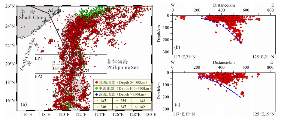
图 5 俯冲带震源分布及剖面图(USGS,2013)(a)震源分布及剖面位置;(b)EP1剖面,俯冲带宽度340 km,俯冲深度220 km;(c)EP2剖面,俯冲带宽度370 km,俯冲深度200 km. Fig. 5 Earthquake distribution in the subduction zone(USGS,2013)(a)Seismic source distribution and profile locations;(b)EP1 profile,subduction zone width 340 km,depth 220 km; (c)EP2 profile,subduction zone width 370 km,depth 200 km. |
一个比较明显的深部地壳结构特征是在青藏高原东北缘的中朝地台—祁连地块—柴达木地块下存在一个中、下地壳低速、低密度体.王有学等(2004,2005)根据地震纵、横波资料建立的阿尔泰—龙门山地学断面的地壳速度及泊松比结构也显示该地区中地壳下部存在一低速层.崔作舟等(1995)的格尔木—额济纳旗地学断面地壳结构研究也发现在祁连山—柴达木盆地的中地壳存在一低速层,并推测其可能是结构疏松或强度较小的软弱层.青藏高原东北缘的中下地壳存在地震P波和S波速度的低速层,暗示了青藏高原下地壳流的分布.同时,这一区域在上地幔顶部的P波低速异常可能反映了温度较高,有助于下地壳流的产生(Li, et al., 2012,2014).本文的反演结果发现其为低密度体,埋深大 约30km,推测其可能是受印度板块的碰撞挤压和上地幔热物质的作用,深部矿物由于高温高压的影响而发生变化,脱水产生部分熔融,形成地壳流,可能是青藏高原东北缘壳内物质流动的通道.
剖面龙门山—武夷山段(A2—A3):莫霍面深度整体呈台阶式抬升,从四川盆地的44 km抬升至武夷山的32 km.四川盆地的莫霍面呈上凸形态,盆地边缘莫霍面深度大,中心深度小(盆地西北侧边缘莫霍面深度46 km,盆地中心约40 km).四川盆地有较厚的沉积层,约8 km.与龙门山断裂(F6)西北侧的松潘—甘孜地块相比,较为明显的是四川盆地下地壳厚度急剧减薄,减薄程度达15 km.该段剖面的华南褶皱带莫霍面特征以绍兴—萍乡—怀集深断裂(F8)为界,F8断裂西北侧的雪峰山地区莫霍面抬升较陡,F8断裂东南侧莫霍面呈缓慢平稳抬升.华南褶皱带构造格局变形较复杂,从西北向东南方向发育有雪峰山推覆构造,罗霄山推覆构造及武夷山推覆构造.雪峰山造山带及其以西地区以挤压变形为主,发育碰撞造山带;以东地区晚中生代以来,以伸展变形为主,发育伸展环境下的巨型S型花岗岩带(蔡学林等,2004).
剖面南海段(A3—A4):南海北部陆架区莫霍面深度从30 km抬升至18 km.剖面最东南端有明显的俯冲带存在,莫霍面形态较复杂.结合震源深度分布(图 5)和地震层析成像研究(范建柯,2013),发现该俯冲带是南海海盆沿马尼拉海沟向东俯冲至菲律宾海板块下,俯冲带两侧的地壳和上地幔密度结构有明显的差异.
剖面上莫霍面深度和深部结构能够清晰地反映中国大陆“三横、两竖、两三角”构造格架(刘光鼎,2007)中的两横和两竖,在昆仑—秦岭—大别这一横以北的准噶尔地块和中朝地台莫霍面深度45~50 km,而其以南至贺兰山—龙门山之间的祁连、柴达木至松潘—甘孜的莫霍面呈“W”型起伏,莫霍面深度由祁连地块北部的50 km,加深至68 km,在柴达木盆地抬升至58 km,在阿尼玛卿山莫霍面降至68 km,向南逐渐抬升至四川盆地的44 km,经大兴安岭—太行山—武陵山这一竖台阶式抬升至华南褶皱带的35 km,在江绍—南岭以南缓慢抬升至南海北部陆架区的20~25 km.
对比密度反演结果与地震层析成像结果,会发现壳内结构,尤其是莫霍面的起伏十分一致.这反映出对于莫霍面这样无论密度还是速度都有较大变化的界面而言,反演结果的可信度和可靠性较高. 5 结论与认识
(1)将中国海、陆置于统一构造演化体系来研究莫霍面深度及深部地壳结构能更好地探索中国大陆宏观构造格架的延伸以及海陆相互作用关系等问 题.从中国海陆及邻区莫霍面深度和梯级带展布可 以得知其总体特征为:“东西分带,南北分块”.在整体宏观构造格架上,刘光鼎(2007)提出的“三横、两竖、两三角”宏观构造格架在深部构造上有较明显的体现.
(2)阿尔泰—巴士海峡剖面上莫霍面深度和深部结构能够清晰地反映中国大陆“三横、两竖、两三角”宏观构造格架中的两横和两竖.在昆仑—秦岭—大别至贺兰山—龙门山之间的祁连、柴达木至松潘—甘孜的莫霍面呈“W”型起伏,起伏较大,落差能达到20 km.从四川盆地到华南褶皱带,莫霍面经大兴安岭—太行山—武陵山台阶式抬升,在江绍—南岭至南海北部陆架区莫霍面缓慢抬升.同时莫霍面深度和深部结构受深大断裂的控制.
(3)在俯冲带等海-陆和洋-洋相互作用地区,莫霍面不仅起伏剧烈,而且构造复杂,应结合俯冲工厂(金性春和于开平,2003)的研究来综合分析深部结构及其海-陆和洋-洋相互作用的过程.
(4)在青藏高原的东北缘的祁连地块—柴达木地块下存在一个中、下地壳低速、低密度体.推测其可能是受印度板块的碰撞挤压和上地幔热物质的作用,形成地壳流,可能是青藏高原东北缘壳内物质流动的通道.
致谢 本文得益于刘光鼎院士提出的“一、二、三、多”的综合地球物理研究方法和“三横、两竖、两三角”的中国宏观构造格架理论,在此表示衷心感谢!中国地质调查局青岛海洋地质研究所张训华研究员、温珍河研究员,中国地质调查局发展研究中心张明华教授、乔计花高级工程师,对本文给予了大量的帮助和提供了十分珍贵的数据资料,在此一并致谢!| [1] | Cai X L, Zhu J S, Cao J M, et al. 2004. Structures of lithosphere and asthenosphere in Heishi of Sichuan-Hualian of Taiwan profile. Journal of Chengdu University of Technology (Science & Technology Edition) (in Chinese), 31(5): 441-451. |
| [2] | Chen J X, Chen J L. 2003. The crustal structure and velocity feature from Ruoqiang-Altai seismic profile in Xinjiang region. Xinjiang Petroleum Geology (in Chinese), 24(6): 498-501. |
| [3] | Chulick G S, Mooney W D. 2002. Seismic structure of the crust and uppermost mantle of North America and adjacent oceanic basins: a synthesis. Bulletin of the Seismological Society of America, 92(6): 2478-2492. |
| [4] | Cui Z Z, Li Q S, Wu C D, et al. 1995. The crustal and deep structures in Golmud-Ejin QI GGT. Chinese J. Geophys. (in Chinese), 38(S2): 15-28. |
| [5] | Fan J K. 2013. The seismic tomographic study for the western margin of the Philippine Sea Plate. Qingdao: Institute of Oceanology, Chinese Academy of Science. |
| [6] | Gao R, Xiao X C, Gao H, et al. 2002. Summary of deep seismic probing of the lithospheric structure across the West Kunlun-Tarim-Tianshan. Regional Geology of China (in Chinese), 21(1): 11-18. |
| [7] | Gao X, Wang W M, Yao Z X. 2005. Crustal structure of China mainland and its adjacent regions. Chinese J. Geophys. (in Chinese), 48(3): 591-601. |
| [8] | Grad M, Tiira T, ESC Working Grp. 2009. The Moho depth map of the European Plate. Geophysical Journal International, 176(1): 279-292. |
| [9] | Guan Z N, An Y L. 1991. Quantitative interpretation of regional magnetic anomalies (in Chinese). Beijing: Geological Press. |
| [10] | Hou Z C. 1981. Filtering of smooth compensation. Geophysical Prospecting For Petrole (in Chinese), (2): 22-29. |
| [11] | Hu S B, Wang J Y, Wang Y H. 1994. Deep temperature and lithospheric thickness long the eastern segment of the Heishui-Quanzhou geotraverse. Acta Geophyscia Sinica (in Chinese), 37(3): 330-337. |
| [12] | Huang J P, Fu R S, Xu P, et al. 2006. Inversion of gravity and topography data for the crust thickness of China and adjacency. Acta Seismologica Sinica (in Chinese), 28(3): 250-258. |
| [13] | Jin X C, Yu K P. 2003. Subduction factory and subduction recycling of continental material. Advance in Earth Sciences (in Chinese), 18(5): 737-744. |
| [14] | Li C L, Xie C L, Lü Q T. 1998. Calculating top and bottom depth effect of geological body by applying potential field power spectrum. Petroleum Geology & Oilfield Deuelopment in Daqing (in Chinese), 17(5): 45-48. |
| [15] | Li S L, Mooney W D. 1998. Crustal structure of China from deep seismic sounding profiles. Tectonophysics, 288(1-4): 105-113. |
| [16] | Li S L, Mooney W D, Fan J C. 2006. Crustal structure of mainland China from deep seismic sounding data. Tectonophysics, 420(1-2): 239-252. |
| [17] | Li Z W, Ni S D, Hao T Y, et al. 2012. Uppermost mantle structure of the eastern margin of the Tibetan plateau from interstation Pn traveltime difference tomography. Earth Planet. Sci. Lett., 335-336: 195-205. |
| [18] | Li Z W, Ni S D, Roecker S. 2014. Interstation Pg and Sg differential traveltime tomography in the northeastern margin of the Tibetan plateau: Implications for spatial extent of crustal flow and segmentation of the Longmenshan fault zone. Physics of the Earth and Planetary Interiors, 227: 30-40. |
| [19] | Liu F T, Xu P F, Liu J S, et al. 2003. The crustal velocity structure of the continental deep subduction belt: study on the eastern Dabie orogen by seismic wide-angle reflection/refraction. Chinese J. Geophys. (in Chinese), 46(3): 366-372. |
| [20] | Liu G D. 1993. Map series of geology and geophysics of China Seas and adjacent regions (in Chinese). Beijing: Science Press. |
| [21] | Liu G D. 1992. Geologic-geophysic features of China seas and adjacent regions (in Chinese). Beijing: Science Press. |
| [22] | Liu G D, Chen J. 2005. Analysis of difficulties in gas-petroleum prospecting in Chinese Pre-Cenozoic relic basin and the corresponding solutions. Progress in Geophys. (in Chinese), 20(2): 273-275. |
| [23] | Liu G D. 2007. Geodynamical evolution and tectonic framework of China. Earth Science Frontiers (in Chinese), 14(3): 39-46. |
| [24] | Mcintosh K, Nakamura Y, Wang T K, et al. 2005. Crustal-scale seismic profiles across Taiwan and the western Philippine Sea. Tectonophysics, 401(1-2): 23-54. |
| [25] | Meissner R, Wever T, Fluh E R. 1987. The Moho in Europe-Implications for crustal development. Ann. Geophys., 5B: 357-364. |
| [26] | Molinari I, Raileanu V, Morelli A. 2012. A Crustal Model for the Eastern Alps Region and a New Moho Map in Southeastern Europe. Pure and Applied Geophysics, 169(9): 1575-1588. |
| [27] | Oldenburg D W. 1974. The inversion and interpretation of gravity anomalies. Geophysics, 39(4): 526-536. |
| [28] | Parker R L. 1973. The rapid calculation of potential anomalies. Geophys. J. Int., 31(4): 447-455. |
| [29] | Qin J X, Hao T Y, Xu Y, et al. 2011. The distribution characteristics and the relationship between the tectonic units of the Moho Depth in South China Sea and Adjacent Areas. Chinese J. Geophys. (in Chinese), 54(12): 3171-3183. |
| [30] | Qin J X. 2012. The study on the distribution of Moho depth and tectonic framework in China and the adjacent area. Beijing: Institute of Geology and Geophysics, Chinese Academy of Science. |
| [31] | Qiu X L, Ye S Y, Wu S M, et al. 2001. Crustal structure across the Xisha Trough, northwestern South China Sea. Tectonophysics, 341(1-4): 179-193. |
| [32] | Sandwell D T, Smith W H F. 2009. Global marine gravity from retracked Geosat and ERS-1 altimetry: Ridge segmentation versus spreading rate. Journal of Geophysical Research: Solid Earth (1978—2012), 114(B1): B01411. |
| [33] | Teng J W, Yan Y F, Zhang H, et al. 2002. Depth distribution of Moho and tectonic framework in eastern Asian continent and its adjacent ocean areas. Science in China (Series D: Earth Sciences) (in Chinese), 32(2): 89-100. |
| [34] | Wang C Y, Lin Z Y, Chen X B, 1995. Comprehensive study of geophysics on geoscience transect from Menyuan, Qinghai province, to Ningde, Fujian province, China. Chinese J. Geophys. (in Chinese), 38(5): 590-598. |
| [35] | Wang M J. 1994. Gravity and magnetic interpretation of Heishui-Quanzhou geosciences transect. Acta Geophyscia Sinica (in Chinese), 37(3): 321-329. |
| [36] | Wang Y X, Han G H, Jiang M, et a1. 2004. Crustal structure along the geosciences transect from Altay to Altun Tagh. Chinese J. Geophys. (in Chinese), 47(2): 240-249. |
| [37] | Wang Y X, Mooney W D, Han G H, et a1. 2005. Crustal P-wave velocity structure from Altyn Tagh to Longmen mountains along the Taiwan-Altay geoscience transect. Chinese J. Geophys. (in Chinese), 48(1): 98-106. |
| [38] | Xu Y, Hao T Y. 2004. Lifting scheme: a promising method in gravity and magnetic data processing. Progress in Geophysics (in Chinese), 19(1): 36-39. |
| [39] | Xu Y, Feng X Y, Shstsilov V I. 1996. Deep velocity structure in the Tianshan region. Seismology and Geology (in Chinese), 18(4): 375-381. |
| [40] | Yan P, Zhou D, Liu Z S. 2001. A crustal structure profile across the northern continental margin of the South China Sea. Tectonophysics, 338(1): 1-21. |
| [41] | Yang W C, Shi Z Q, Hou Z Z, et al. 2001. Discrete wavelet transform for multiple decomposition of gravity anomalies. Chinese J. Geophys. (in Chinese), 44(4): 534-541. |
| [42] | Yao Y. 1995. Improvement on nonlinear geophysical inversion simulated annealing. Acta Geophysica Sinica (in Chinese), 38(5): 643-650. |
| [43] | Zeng R S, Sun W G, Mao T E, et al. 1995. The map of Moho depth in China. Acta Seismologica Sinica (in Chinese), 17(3): 322-327. |
| [44] | Zhang Z J, Bai Z M, Mooney W, et al. 2009. Crustal structure across the Three Gorges area of the Yangtze platform, central China, from seismic refraction/wide-angle reflection data. Tectonophysics, 475(3-4): 423-437. |
| [45] | 蔡学林, 朱介寿, 曹家敏等. 2004. 四川黑水—台湾花莲断面岩石圈与软流圈结构. 成都理工大学学报(自然科学版), 31(5): 441-451. |
| [46] | 陈俊湘, 陈景亮. 2003. 若羌—阿勒泰区域剖面的速度特征和地壳结构. 新疆石油地质, 24(6): 498-501. |
| [47] | 崔作舟, 李秋生, 吴朝东等. 1995. 格尔木—额济纳旗地学断面的地壳结构与深部构造. 地球物理学报, 38(S2): 15-28. |
| [48] | 范建柯. 2013. 菲律宾海板块西边缘的地震层析成像研究[博士论文]. 青岛: 中国科学院海洋研究所. |
| [49] | 高锐, 肖序常, 高弘等. 2002. 西昆仑—塔里木—天山岩石圈深地震探测综述. 地质通报, 21(1): 11-18. |
| [50] | 高星, 王卫民, 姚振兴. 2005. 中国及邻近地区地壳结构. 地球物理学报, 48(3): 591-601. |
| [51] | 管志宁, 安玉林. 1991. 区域磁异常定量解释. 北京: 地质出版社. |
| [52] | 侯重初. 1981. 补偿圆滑滤波方法. 石油物探, (2): 22-29. |
| [53] | 胡圣标, 汪集旸, 汪屹华. 1994. 黑水—泉州地学断面东段深部温度与岩石层厚度. 地球物理学报, 37(3): 330-337. |
| [54] | 黄建平, 傅容珊, 许萍等. 2006. 利用重力和地形观测反演中国及邻区地壳厚度. 地震学报, 28(3): 250-258. |
| [55] | 金性春, 于开平. 2003. 俯冲工厂和大陆物质的俯冲再循环研究. 地球科学进展, 18(5): 737-744. |
| [56] | 李成立, 谢春临, 吕庆田. 1998. 利用位场功率谱计算地质体顶底深度效果. 大庆石油地质与开发, 17(5): 45-48. |
| [57] | 刘福田, 徐佩芬, 刘劲松等. 2003. 大陆深俯冲带的地壳速度结构——东大别造山带深地震宽角反射/折射研究. 地球物理学报, 46(3): 366-372. |
| [58] | 刘光鼎. 1993. 中国海区及邻域地质地球物理图集. 北京: 科学出版社. |
| [59] | 刘光鼎. 1992. 中国海区及邻域地质地球物理特征. 北京: 科学出版社. |
| [60] | 刘光鼎, 陈洁. 2005. 中国前新生代残留盆地油气勘探难点分析及对策. 地球物理学进展, 20(2): 273-275. |
| [61] | 刘光鼎. 2007. 中国大陆构造格架的动力学演化. 地学前缘, 14(3): 39-46. |
| [62] | 秦静欣, 郝天珧, 徐亚等. 2011. 南海及邻区莫霍面深度分布特征及其与各构造单元的关系. 地球物理学报, 54(12): 3171-3183. |
| [63] | 秦静欣. 2012. 中国海陆及邻区莫霍面深度特征研究与构造格架[博士论文]. 北京: 中国科学院研究生院. |
| [64] | 滕吉文, 闫雅芬, 张慧等. 2002. 东亚大陆及周边海域Moho界面深度分布和基本构造格局. 中国科学(D辑: 地球科学), 32(2): 89-100. |
| [65] | 王椿镛, 林中洋, 陈学波. 1995. 青海门源—福建宁德地学断面综合地球物理研究. 地球物理学报, 38(5): 590-598. |
| [66] | 王懋基.1994.黑水—泉州地学断面的重磁解释. 地球物理学报,37(3): 321-329. |
| [67] | 王有学, 韩果花, 姜枚等. 2004. 阿尔泰—阿尔金地学断面地壳结构. 地球物理学报, 47(2): 240-249. |
| [68] | 王有学, Mooney W D, 韩果花等. 2005. 台湾—阿尔泰地学断面阿尔金—龙门山剖面的地壳纵波速度结构. 地球物理学报, 48(1): 98-106. |
| [69] | 徐亚, 郝天珧. 2004. 提升小波: 可用于重磁资料处理的新方法. 地球物理学进展, 19(1): 36-39. |
| [70] | 胥颐, 冯先岳, Shstsilov V I. 1996. 天山地区的深部速度结构. 地震地质, 18(4): 375-381. |
| [71] | 杨文采, 施志群, 侯遵泽等. 2001. 离散小波变换与重力异常多重分解. 地球物理学报, 44(4): 534-541. |
| [72] | 姚姚. 1995. 地球物理非线性反演模拟退火法的改进. 地球物理学报, 38(5): 643-650. |
| [73] | 曾融生, 孙为国, 毛桐恩等. 1995. 中国大陆莫霍界面深度图. 地震学报, 17(3): 322-327. |
 2014, Vol. 57

