 2013, Vol. 56


在构造活动强烈的造山带,周期性复发的强震的同震垂直位移累积被认为是山脉持续隆升的一个重要驱动因素[1].地震同时也导致了大量地表物质的迁移[2-3],改变了地形地貌[4].当同震构造变形驱动的地表抬升量大于同震滑坡的地表剥蚀量,结果是山脉平均高程的增加,反之,是山脉平均高程的降低[4].然而,这种关系的确立将取决于地震滑坡物质河流卸载时间与强震复发周期长短的比较[5].因此定量化研究地震滑坡物质河流卸载时间对理解地震与造山带地貌演化的关系有着十分重要的意义. 2008年汶川地震最大地表同震垂直位移量达约9~10m[6-8],地震触发了大量的滑坡[7, 9-10].经过计算,Parker等[4]认为汶川地震同震剥蚀的物质质量大于地震同震抬升导致的物质增加量,进而提出类似汶川地震的强震在龙门山并没有产生造山的作用.另外,Ouimet[11]认为强震触发的滑坡增加了龙门山地区千年尺度的侵蚀速率.但是这些研究缺少对地震滑坡物质的河流卸载时间的估算,而估算地震滑坡物质的河流卸载时间将有助于对青藏高原东缘大地震、滑坡侵蚀和地貌演化之间关系的认识.
岷江为流经龙门山地区流量最大的河流,2008年汶川地震沿岷江干流两岸诱发了大量滑坡(图 1),这为研究地震滑坡物质河流卸载提供了良好机会.因此,岷江流域是研究地震活动与地形地貌演化关系的一个理想地区.本研究将定量地估算岷江对汶川地震滑坡物质卸载可能所需时间,并讨论大地震事件滑坡物质的卸载对龙门山晚新生代构造地貌演化的影响.

|
图 1 沿岷江干流(图中蓝色粗线)发育了2008年汶川地震所诱发的大量滑坡 Fig. 1 Large-scale landslides induced by the 2008 Wenchuan earthquake along the Minjiang River (thick blue lines) |
龙门山构造带是中国典型的推覆构造发育地区之一,形成于中生代和早新生代,主要由大致平行的三条逆冲、逆冲-走滑断裂带组成[12]:自北西向南东发育汶川-茂县断裂(F1)、映秀-北川断裂(F2)和灌县-安县断裂(F3).汶川地震是龙门山断裂带的映秀-北川断裂突发错动的结果[13-14],在地表上形成了300多公里长的地表破裂带,地表破裂带变形特征以逆冲为主兼具右旋走滑分量[13-17].龙门山地貌上是青藏高原东缘与四川盆地的分界线,也是青藏高原周缘地形梯度变化最大的地区,在不到50km的范围内地形平均高程从4000m变化到500m.其中龙门山中段是龙门山地形地貌特征典型的地区[18],也是地震活动频发区[19-20].
岷江发源于岷山南麓,向南流经岷山构造带和龙门山构造带,都江堰以上的上游段河道长约340km,在龙门山断裂带内表现为深切河谷、基岩型河道[21].在龙门山构造带岷江沿汶川-茂县断裂带(F1)成北东-南西向流动,然后沿东南方向斜切映秀-北川断裂带(F2)和安县-灌县断裂带(F3),经都江堰流入四川盆地(图 2).本文研究的岷江是指位于都江堰以上发育于龙门山构造带的岷江干流.

|
图 2 研究区主要活动构造及位置图(蓝色虚线矩形为所研究的岷江河段) F1为汶川-茂县断裂, F2为映秀-北川断裂, F3为灌县-安县断裂, F4为岷江断裂. Fig. 2 Topography and active faults in the central Longmen Shan orogenic belt (The dashed rectangle shows location of study area) F1:Wenchuan-Maoxian fault, F2:Yingxiu-Beichuan fault, F3:Guanxian-Anxian fault, F4:Minjiang fault |
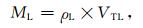
河流搬运物质通常以溶解质、悬移质和底移质三种形态存在.溶解质所占比例非常小[22],在特殊的气候和岩性条件下才会考虑溶解质对地貌演化的贡献.地震滑坡物质大量进入河道,以河流悬移质形式存在的地震滑坡物质随河水而流动,其河流卸载时间可能很快.Hovius等[23]报道了台湾集集地震震后10年河流悬移质含量就恢复到了震前水平.河流底移质的移动速度相对悬移质来说较慢,以河流底移质形式存在的地震滑坡物质的河流卸载时间可能相对较长.在长期的地貌演化过程中,河流物质中底移质对河流过程和形态的影响最大[24].此外,河流底移质一般占河流中总物质量的30%[25],甚至可以达到50%[22].因此,我们选择定量计算以底移质形式存在的地震滑坡物质的河流卸载时间.同时假设地震滑坡物质进入河道后,30%的物质以河流底移质的形式存在.本文采用Yanites等[26]的方法估算地震滑坡物质的河流卸载时间(T).T可表示为区域滑坡物质的质量(ML)与河流底移质的搬运能力(QT)的比值,公式为

|
(1) |
区域滑坡物质的质量由公式(2)和(4)得到
|
(2) |
式中,ρL为滑坡物质的密度,VTL为地震滑坡总方量.龙门山中部第四纪地层坡度较缓,不易发生滑坡,汶川地震中大量的滑坡发生在较老的岩层中,92%的滑坡发生在第三纪以前的地层中[27],可认为汶川地震滑坡主要为岩质滑坡,而龙门山地表岩石的密度为2450kg/m3[28],所以我们假设地震滑坡物质的密度为2450kg/m3.
区域滑坡物质的单个滑坡体方量由公式(3)[29]得到

|
(3) |
其中VL为单个滑坡方量,AL为单个滑坡面积,R2为决定系数.Larsen等[30]认为滑坡方量(V)和面积(A)具有幂律的关系V=aAb(a、b是常数),对于岩质滑坡,b=1.3-1.6.因此我们选择此公式计算单个滑坡的方量.以此经验公式为基础,建立岷江流域地震滑坡总方量公式为

|
(4) |
式中N是研究区内滑坡个数.
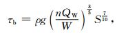
3.2 河床剪切应力在基岩型河道剪切应力侵蚀模型中,用河床剪切应力表征河流对河床侵蚀能力大小[31-32].河床剪切应力(τb)由公式(5)[33]表示为
|
(5) |
式中,W为河宽,河宽数据采集自1:50000地形图,部分地区来源于空间分辨率为28.5m的Landsat ETM遥感影像(http://glovis.usgs.gov/).S为河流的坡度,提取自空间分辨率为90m的SRTMDEM数据(http://srtm.csi.cgiar.org/).由于部分高程数据在90m距离内并无变化,使得相邻两个像元的高程差为0,因此计算的坡度也为零.经过反复试验,以水平距离1000m提取河流坡度可消除此效应.n是曼宁系数,对于山区河通常取值为0.04[34]. QW为河流多年平均流量(m3/s).
岷江流域是人类社会经济活动较频繁的地域,在岷江及其支流上建造了大量的水电站,势必影响河流的流量(图 3).例如,岷江上游映秀湾水电站建于1965-1972年,是一座比较大的水电站.岷江出山口紫坪铺水文站记录的河流流量数据显示:映秀湾水电站建站前10年河流的平均流量为463m3/s,建站后10年河流的平均流量为442m3/s.由于河流的流量影响基岩型河道的剪切应力计算,河流的实际搬运能力可能会被低估.岷江流域大规模的水电建设开始于1980年以后[35].为减少人类经济活动对计算带来的误差,因此,河流多年平均流量选用1980以前岷江各站水文数据,数据来源于长江流域水文资料[36].

|
图 3 映秀湾水电站建设前后河流流量变化图(灰色阴影区为水电站建设期间, 数据资料来源自http://www.mwr.gov.cn/) Fig. 3 The inter-annual change of flow discharge before and after the construction of the Yingxiuwan dam.The grey shadow region is construction period of the dam (http://www.mwr.gov.cn/) |
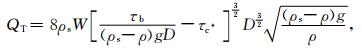
河流底移质搬运能力(QT)由公式(6)[37]表示:
|
(6) |
式中,ρs为底移质的密度,值为2.65g/cm3,ρ为水的密度,值为1g/cm3,g为重力加速度,值为9.8m/s2. D为底移质的中值粒径(cm),岷江河床底移质值中值粒径为10cm[38].τb为河床剪切应力,τc*为河床临界启动剪切应力,对于基岩型河道,河床临界启动剪切应力数值通常变化范围为0.03~0.08[39].我们取常数0.03作为岷江的河床临界启动剪切应力.
4 结果图 4显示岷江搬运能力整体变化平稳,往出山口方向具有变大的趋势.在河流斜穿断层F2和F3的位置,河流有着较高的搬运能力.因为断层所处位置也是龙门山地形梯度变化较大的地方,河流的比降变化较快(图 5a).河流在比降大的地方有着较大的重力势能,因而对沉积物具有较强的搬运能力.另外,河床剪切力空间分布也说明了位于龙门山构造带内岷江河段的水动力条件具有类似的空间分布特征(图 5b).当上游的河流搬运能力小于下游,地震滑坡物质则由河流下游相对上游的“剩余”的搬运能力来搬运,此时根据公式(1)计算的结果为河流搬运时间的下限[26].根据公式(2)计算研究区内滑坡物质质量约为17885Mt,根据公式(6)计算岷江上下游搬运能力的差值为1.73×10⁹kg/yr.如果岷江保持现有的搬运能力并且有能力完全搬运地震滑坡物质,那么岷江流域的所有地震滑坡物质被河流搬运出龙门山至少需要3100yr.

|
图 4 龙门山构造带中段岷江河段搬运能力的空间分布特征 F1为汶川-茂县断裂, F2为映秀-北川断裂, F3为灌县-安县断裂. Fig. 4 The spatial distribution of the sediment transport capacity along the Minjiang River in the central Longmen Shan orogenic belt F1:Wenchuan-Maoxian fault, F2:Yingxiu-Beichuan fault, F3:Guanxian-Anxian fault |

|
图 5 龙门山构造带中段岷江河段的河流比降(a)和河床剪切应力(b)空间分布特征 F1为汶川-茂县断裂, F2为映秀-北川断裂, F3为灌县-安县断裂. Fig. 5 Spatial distribution of the river slopes (a) and the shear stress (b) along the Minjiang River in the central Longmen Shan orogenic belt F1:Wenchuan-Maoxian fault, F2:Yingxiu-Beichuan fault, F3:Guanxian-Anxian fault |
前人研究结果表明龙门山断裂带中段强震的复发周期可能约为2000~3000yr[19, 40-41],与地震滑坡物质河流卸载时间相比,暗示岷江对汶川地震滑坡物质搬运时间可能略长于一个地震周期.换句话说,至少在龙门山中段在一个地震周期内绝大部分地震滑坡物质可以被卸载出龙门山.需要说明的是我们定量估算的结果仍受到一些不确定因素的影响,比如地质历史时期气候变化对河流流量的可能影响,地震滑坡堵江形成堰塞湖对河流底移质搬运能力的影响,滑坡物质从坡面进入河道的时间,以及现代大坝建设对底移物质搬运的影响.尽管如此,在龙门山晚新生代长期的地貌演化过程中,地震滑坡物质被卸载的速度可能是很快的.因为在龙门山山谷和河谷中缺少大面积裸露的基岩和滞留过厚的(厚度大于100m)沉积物[21, 42].另外,龙门山山前快速堆积的一套厚度大于500m的晚新生代沉积物可能与长期重复发生的大地震活动有关[43],从侧面也说明了岷江的河流卸载作用很强.龙门山中段类似2008年汶川大地震复发周期是根据经验公式计算出来,存在一定误差,地震物质河流卸载时间结果也存在一些不确定因素的影响,但是从我们的估算结果来看二者的量级几乎一致.
在龙门山造山带晚新生代隆升历史过程中,龙门山地区每次逆冲型大地震都会形成不同规模的地表垂直位移和同震滑坡,如果大地震产生的滑坡物质被侵蚀和剥蚀所平衡,那么为什么目前龙门山仍然会保持高大而陡峻的地形?我们认为与河流对龙门山剥蚀物质的长期快速的卸载作用有关.由于河流对龙门山山脉体系内剥蚀物质的快速卸载,引起壳幔边界Moho面均衡反弹[44-45],促使地表抬升[7],使得龙门山主峰高出青藏高原内部,从而形成龙门山现今的高陡山峰.但是剥蚀卸载引起的均衡反弹只是使山峰的高度比剥蚀前更高,山脉的平均高程应该是在逐步降低的[46].值得注意的是,龙门山地区古地形重建结果显示,在3.6Ma以前,龙门山与青藏高原内部高程相近,但小于现代平均高程[47].说明可能还有别的地球动力学作用机制在维持着龙门山整体持续的隆升.我们推断可能是由于地表剥蚀物质的快速卸载诱发了龙门山下部深部物质的上涌导致了龙门山持续的隆升(图 6).横跨龙门山断裂带的被动源地震探测数据和大地电磁数据揭示[44-45, 48-49]:龙门山及其以西部分地区下部为低速异常,指示可能存在由于岩石圈深部物质上涌;四川盆地西部与松潘-甘孜为高速异常,指示可能有地幔物质的下潜.这些地球物理探测结果暗示青藏高原东部可能存在局部的地幔物质垂向对流.因此,地幔岩浆物质上涌可能是高原东部抬升的主要因素之一.另外,下地壳的流变特性在地壳内物质均衡重置过程中也起到了重要作用[50].层析成像结果揭示青藏高原东部中下地壳刚性较小[51-52],具备流动的条件[53-57],所以下地壳的部分物质也可能受到了上地幔垂向运动的作用而在龙门山造山带下方蓄积.因此,地表剥蚀(或侵蚀)物质的快速卸载驱动地壳均衡反弹,形成了龙门山构造带现今的高陡山峰;另一方面,诱发龙门山构造带下方的深部物质上涌,形成顶托作用,有利于龙门山保持高陡的地形特征.

|
图 6 龙门山晚新生代隆升的地球动力学机制示意图 (a)伴随着周期性大地震的复发, 龙门山下方地壳缩短增厚; 与此同时, 河流长期对地震滑坡及其它地表剥蚀物质的快速卸载引起龙门山地壳均衡反弹, 形成高陡山峰; (b)均衡反弹诱发深部物质的上涌, 从而维持了龙门山高陡的地形特征. Fig. 6 Geodynamic model for the uplift processes of Longmen Shan orogenic belt during late Cenozoic (a) with the repeated large seismic events, the crust under the Longmen Shan is shortened.At the same time, the long-term fluvial unloading of erosion material produced by earthquake-related landslides may induce isostatic crutsal-mantle boundary rebound, which lead to formation of the high and steep orogenic summit; (b)the isostatic rebound further triggers the deep mantle upwelling and maintains the present-day steep topography |
山脉如果失去持续的内动力作用,将很快会被地表作用夷平[58].然而龙门山在地壳水平变形速率很小的情况下[59-60],依然保持了高陡的地形特征,并没有被水系和其它地表作用消减,说明内动力在持续的作用于龙门山的抬升.而这很可能与大地震的频繁发生有关,大地震的周期性复发标志了龙门山构造变形强烈,所以周期性大地震造成的地表抬升的累积可能是龙门山晚新生代以来高陡地貌形成的主要因素[7].尽管如此,地表剥蚀快速卸载诱发的深部物质活动在龙门山高陡地貌特征的形成中也起到了重要作用.诚然,对这一过程仍需作进一步的研究.需要说明的是,大地震引发的大范围、大规模的滑坡是龙门山地表过程中的重要力量,但是除了地震滑坡侵蚀,其它成因的地表剥蚀物质的快速卸载对龙门山的均衡反弹也应有贡献.均衡反弹是形成和维持造山带的高地形特征的重要深部过程[58, 61],所以对龙门山地貌上的高陡地形梯度带成因的研究不应忽视均衡反弹的作用[62].因此,地表作用和深部地球物理过程的共同作用塑造了龙门山现今独特的地貌特征.
6 结论根据上述分析,得出如下初步结论和认识:
(1) 根据经验公式估算出汶川地震滑坡物质的总质量约为17885Mt.汶川地震滑坡物质进入岷江河道后,如果30%的地震滑坡物质以底移质的形式存在,在现今龙门山中段岷江的河流水动力条件下,汶川地震滑坡物质被岷江卸载出龙门山至少需要3100yr.
(2) 龙门山中段类似2008年汶川大地震的复发周期约为3000yr,暗示大地震产生的同震滑坡物质可能在相同时间段内被河流卸载作用平衡,并被卸载出龙门山构造带.
(3) 我们推断在龙门山长期的地貌演化过程中,除了周期性大地震造成的地表构造抬升累积外,周期性大地震相关的地表侵蚀物质快速卸载所驱动的地壳均衡反弹及诱发的深部地幔对流也造成龙门山的隆升作用,这可能是龙门山晚新生代隆升的重要地球动力学机制之一.
致谢感谢评审人提出的建设性修改意见和建议,感谢美国科罗拉多大学的BrianJ.Yanites博士的有益讨论.
| [1] | Avouac J P. Dynamic Processes in extensional and compressional settings-mountain building:from earthquakes to geological deformation. Treatise on Geophysics , 2008, 6: 377-439. |
| [2] | Hovius N, Stark C P, Allen P A. Sediment flux from a mountain belt derived by landslide mapping. Geology , 1997, 25(3): 231-234. DOI:10.1130/0091-7613(1997)025<0231:SFFAMB>2.3.CO;2 |
| [3] | Hovius N, Stark C P, Chu H T, et al. Supply and removal of sediment in a landslide-dominated mountain belt:Central Range, Taiwan. Journal of Geology , 2000, 108(1): 73-89. DOI:10.1086/314387 |
| [4] | Parker R N, Densmore A L, Rosser N J, et al. Mass wasting triggered by the 2008 Wenchuan earthquake is greater than orogenic growth. Nature Geoscience , 2011, 4(7): 449-452. DOI:10.1038/ngeo1154 |
| [5] | Ouimet W B. The hills came tumbling down. Nature Geoscience , 2011, 4(7): 424-425. DOI:10.1038/ngeo1199 |
| [6] | 李海兵, 王宗秀, 付小方, 等. 2008年5月12日汶川地震(Ms8.0)地表破裂带的分布特征. 中国地质 , 2008, 35(5): 803–813. Li H B, Wang Z X, Fu X F, et al. The surface rupture zone distribution of the Wenchuan earthquake (Ms8.0) happened on May 12th, 2008. Chinese Geology (in Chinese) , 2008, 35(5): 803-813. |
| [7] | Fu B H, Shi P L, Guo H D, et al. Surface deformation related to the 2008 Wenchuan earthquake, and mountain building of the Longmen Shan, eastern Tibetan Plateau. Journal of Asian Earth Science , 2011, 40(4): 805-824. DOI:10.1016/j.jseaes.2010.11.011 |
| [8] | Ran Y K, Shi X, Wang H, et al. The maximum coseismic vertical surface displacement and surface deformation pattern accompanying the Ms8.0 Wenchuan earthquake. Chinese Science Bulletin , 2010, 55(9): 841-850. DOI:10.1007/s11434-009-0453-3 |
| [9] | Dai F C, Xu C, Yao X, et al. Spatial distribution of landslides triggered by the 2008Ms8.0 Wenchuan earthquake, China. Journal of Asian Earth Science , 2011, 40(4): 883-895. DOI:10.1016/j.jseaes.2010.04.010 |
| [10] | Huang R Q, Li W L. Development and distribution of geohazards triggered by the 5.12 Wenchuan Earthquake in China. Science in China Series E:Technological Science , 2009, 52(4): 810-819. DOI:10.1007/s11431-009-0117-1 |
| [11] | Ouimet W B. Landslides associated with the May 12, 2008 Wenchuan earthquake:Implications for the erosion and tectonic evolution of the Longmen Shan. Tectonophysics , 2010, 491(1-4): 244-252. DOI:10.1016/j.tecto.2009.09.012 |
| [12] | Burchfiel B C, Chen Z L, Liu Y P, et al. Tectonics of the Longmen shan and adjacent region. Central China International Geology Review , 1995, 37(8): 661-735. DOI:10.1080/00206819509465424 |
| [13] | Xu X W, Wen X Z, Yu G H, et al. Coseismic reverse-and oblique-slip surface faulting generated by the 2008Mw7.9 Wenchuan earthquake, China. Geology , 2009, 37(6): 515-518. DOI:10.1130/G25462A.1 |
| [14] | 张培震, 徐锡伟, 闻学泽, 等. 2008年汶川8.0级地震发震断裂的滑动速率、复发周期和构造成因. 地球物理学报 , 2008, 51(4): 1066–1073. Zhang P Z, Xu X W, Wen X Z, et al. Slip rates and recurrence intervals of the Longmen Shan active fault zone, and tectonic implication for the mechanism of the May 12 Wenchuan earthquake, 2008, Sichuan, China. Chinese J. Geophys. (in Chinese) , 2008, 51(4): 1066-1073. |
| [15] | 付碧宏, 时丕龙, 张之武. 四川汶川Ms8.0大地震地表破裂带的遥感影像解析. 地质学报 , 2008, 82(12): 1679–1687. Fu B H, Shi P L, Zhang Z W. Spatial characteristics of the surface rupture produced by the Ms8.0 Wenchuan earthquake using high-resolution remote sensing imagery. Acta Geologica Sinica (in Chinese) , 2008, 82(12): 1679-1687. |
| [16] | 李海兵, 付小方, WoerdJ V D, 等. 汶川地震(Ms8.0)地表破裂及其同震右旋斜向逆冲作用. 地质学报 , 2008, 82(12): 1623–1643. Li H B, Fu X F, Woerd J V D, et al. Co-seismic surface rupture and dextral-slip oblique thrusting of the Ms8.0 Wenchuan earthquake. Acta Geologica Sinica (in Chinese) , 2008, 82(12): 1623-1643. |
| [17] | Zhang P Z, Wen X Z, Shen Z K, et al. Oblique, high-angle, listric-reverse faulting and associated development of strain:The Wenchuan earthquake of May 12, 2008, Sichuan, China. Annual Review of Earth and Planetary Sciences , 2010, 38: 353-382. DOI:10.1146/annurev-earth-040809-152602 |
| [18] | 李智武, 陈洪德, 刘树根, 等. 龙门山冲断隆升及其走向差异的裂变径迹证据. 地质科学 , 2010, 45(4): 944–968. Li Z W, Chen H D, Liu S G, et al. Diferential uplift driven by thrusting and its lateral variation along the Longmen shan belt, western Sichuan, China:Evidence from fission track thermochronology. Chinese Journal of Geology (in Chinese) , 2010, 45(4): 944-968. |
| [19] | 闻学泽, 张培震, 杜方, 等. 2008年汶川8.0级地震发生的历史与现今地震活动背景. 地球物理学报 , 2009, 52(2): 444–454. Wen X Z, Zhang P Z, Du F, et al. The backgound of historical and modern seismic activities of the occurrence of the 2008Ms8.0 Wenchuan Sichuan, earthquake. Chinese J. Geophys. (in Chinese) , 2009, 52(2): 444-454. |
| [20] | 赵小麟, 邓起东, 陈社发. 龙门山逆断裂带中段的构造地貌学研究. 地震地质 , 1994, 16(4): 422–428. Zhao X L, Deng Q D, Chen S F. Tectonic geomorphology of the central segment of the Longmenshan thrust belt, western sichuan, southewestern China. Seismology and Geology (in Chinese) , 1994, 16(4): 422-428. |
| [21] | Kirby E, Whipple K X, Tang W, et al. Distribution of active rock uplift along the eastern margin of the Tibetan Plateau:Inferences from bedrock channel longitudinal profiles. J. Geophys. Res. , 2003, 108(B4): 2217. DOI:10.1029/2001jb000861 |
| [22] | Galy A, France-Lanord C. Higher erosion rates in the Himalaya:Geochemical constraints on riverine fluxes. Geology , 2001, 29(1): 23-26. DOI:10.1130/0091-7613(2001)029<0023:HERITH>2.0.CO;2 |
| [23] | Hovius N, Meunier P, Lin C W, et al. Prolonged seismically induced erosion and the mass balance of a large earthquake. Earth and Planetary Science Letters , 2011, 304(3-4): 347-355. DOI:10.1016/j.epsl.2011.02.005 |
| [24] | Pratt-Sitaula B, Garde M, Burbank D W, et al. Bedload-to-suspended load ratio and rapid bedrock incision from Himalayan landslide-dam lake record. Quaternary Research , 2007, 68(1): 111-120. DOI:10.1016/j.yqres.2007.03.005 |
| [25] | Yanites B J, Tucker G E, Hsu H L, et al. The influence of sediment cover variability on long-term river incision rates:An example from the Peikang River, central Taiwan. J. Geophys. Res. , 2011, 116(F3): F03016. DOI:10.1029/2010jf001933 |
| [26] | Yanites B J, Tucker G E, Mueller K J, et al. How rivers react to large earthquakes:Evidence from central Taiwan. Geology , 2010, 38(7): 639-642. DOI:10.1130/G30883.1 |
| [27] | Qi S W, Xu Q, Lan H X, et al. Spatial distribution analysis of landslides triggered by 2008.5. 12 Wenchuan earthquake, China. Engineering Geology , 2010, 116(1-2): 95-108. DOI:10.1016/j.enggeo.2010.07.011 |
| [28] | Jiang X D, Jin Y. Mapping the deep lithospheric structure beneath the eastern margin of the Tibetan Plateau from gravity anomalies. J. Geophy. Res., 2005, 110, doi:10.1029/2004JB 003394. |
| [29] | Guzzetti F, Ardizzone F, Cardinali M, et al. Landslide volumes and landslide mobilization rates in Umbria, central Italy. Earth and Planetary Science Letters , 2009, 279(3-4): 222-229. DOI:10.1016/j.epsl.2009.01.005 |
| [30] | Larsen I J, Montgomery D R, Korup O. Landslide erosion controlled by hillslope material. Nature Geoscience , 2010, 3(4): 247-251. DOI:10.1038/ngeo776 |
| [31] | Howard A D. A detachment-limited model of drainage basin evolution. Water Resources Research , 1994, 30(7): 2261-2286. DOI:10.1029/94WR00757 |
| [32] | Lavé J, Avouac J. Fluvial incision and tectonic uplift across the Himalayas of central Nepal. J. Geophys. Res. , 2001, 106(B11): 26561-26591. DOI:10.1029/2001JB000359 |
| [33] | Yanites B J, Tucker G E, Mueller K J, et al. Incision and channel morphology across active structures along the Peikang River, central Taiwan:Implications for the importance of channel width. Geological Society of America Bulletin , 2010, 122(7-8): 1192-1208. DOI:10.1130/B30035.1 |
| [34] | Barnes Jr H H. Roughness characteristics of natural channels.U. S. Geological Survey Water Supply Paper 1849. Washington, DC:United States Government Printing Office , 1967: 213. |
| [35] | http://www.mwr.gov.cn/ |
| [36] | 长江流域水文资料. 1950-1983. (岷江沱江区) Hydrometric Data of The Changjiang River Drainage Basin (in Chinese). 1950-1983, (Minjiang and Tuojiang) |
| [37] | Meyer-Peter E, Muller R. Formulas for bed-load transport. paper presented at 2nd Meeting, International Assocciaion for Hydraulic Structures Research , 1948: 39-64. |
| [38] | Godard V, Lavé J, Carcaillet J, et al. Spatial distribution of denudation in Eastern Tibet and regressive erosion of plateau margins. Tectonophysics , 2010, 491(1-4): 253-274. DOI:10.1016/j.tecto.2009.10.026 |
| [39] | Buffington J M, Montgomery D R. A systematic analysis of eight decades of incipient motion studies, with special reference to gravel-bedded rivers. Water Resour. Res. , 1997, 33(8): 1993-2029. DOI:10.1029/96WR03190 |
| [40] | Ran Y K, Chen L C, Chen J, et al. Paleoseismic evidence and repeat time of large earthquakes at three sites along the Longmenshan fault zone. Tectonophysics , 2010, 491(1-4): 141-153. DOI:10.1016/j.tecto.2010.01.009 |
| [41] | 李勇, 周荣军, DensemoreA L, 等. 青藏高原东缘大陆动力学过程与地质响应 , 2006: 1–152. Li Y, Zhou R J, Densemore A L, et al. Geodynamic Processes of the Eastern Margin of the Tibetan Plateau and Its Geological Responses (in Chinese) , 2006: 1-152. |
| [42] | Ouimet W B, Whipple K X, Granger D E. Beyond threshold hillslopes:Channel adjustment to base-level fall in tectonically active mountain ranges. Geology , 2009, 37(7): 579-582. DOI:10.1130/G30013A.1 |
| [43] | Wang E C, Meng Q R. Mesozoic and Cenozoic tectonic evolution of the Longmenshan fault belt. Science in China Series D:Earth Sciences , 2009, 52(5): 579-592. DOI:10.1007/s11430-009-0053-8 |
| [44] | Zhang Z J, Wang Y H, Chen Y, et al. Crustal structure across Longmenshan fault belt from passive source seismic profiling. Geophys. Res. Lett. , 2009, 36. DOI:10.1029/2009GL039580 |
| [45] | Zhang Z J, Yuan X H, Chen Y, et al. Seismic signature of the collision between the east Tibetan escape flow and the Sichuan Basin. Earth and Planetary Science Letters , 2010, 292(3-4): 254-264. DOI:10.1016/j.epsl.2010.01.046 |
| [46] | Burbank D W, Anderson R S. Tectonic Geomorphology. Oxford:Blackwell Publishing House , 2001: 8-9. |
| [47] | 王岩, 付碧宏, 刘少峰.龙门山晚新生代地表剥蚀与均衡抬升.//第四届构造地质与地球动力学学术研讨会论文摘要集.南京, 2011:638-639. Wang Y, Fu B H, Liu S F. Late cenozoic erosion-induced isostatic rebond in the Longmen Shan.//4th National Symposium on Structure Geology & Geodynamics. Proceeding Abstracts. Nanjing, 2011:638-639. |
| [48] | Bai Z M, Tian X B, Tian Y. Upper mantle P-wave tomography across the Longmenshan fault belt from passive-source seismic observations along Aba-Longquanshan profile. Journal of Asian Earth Sciences , 2011, 40(4): 873-882. DOI:10.1016/j.jseaes.2010.04.036 |
| [49] | Zeitler P K, Meltzer A S, Koons P O, et al. Erosion, Himalayan geodynamics, and the geomorphology of metamorphism. GSA Today , 2001, 11(1): 4-9. DOI:10.1130/1052-5173(2001)011<0004:EHGATG>2.0.CO;2 |
| [50] | Xu Z J, Song X D. Joint inversion for crustal and Pn velocities and Moho depth in Eastern Margin of the Tibetan Plateau. Tectonophysics , 2010, 491(1-4): 185-193. DOI:10.1016/j.tecto.2009.11.022 |
| [51] | Li H Y, Su W, Wang C Y, et al. Ambient noise Love wave tomography in the eastern margin of the Tibetan plateau. Tectonophysics , 2010, 491(1-4): 194-204. DOI:10.1016/j.tecto.2009.12.018 |
| [52] | Yao H J, Beghein C, Van Der Hilst R D. Surface wave array tomography in SE Tibet from ambient seismic noise and two-station analysis-Ⅱ. Crustal and upper-mantle structure. Geophysical Journal International , 2008, 173(1): 205-219. DOI:10.1111/gji.2008.173.issue-1 |
| [53] | 雷建设, 赵大鹏, 苏金蓉, 等. 龙门山断裂带地壳精细结构与汶川地震发震机理. 地球物理学报 , 2009, 52(2): 339–345. Lei J S, Zhao D P, Su J R, et al. Fine seismic structure under the Longmenshan fault zone and the mechanism of the large Wenchuan earthquake. Chinese J. Geophys. (in Chinese) , 2009, 52(2): 339-345. |
| [54] | 胥颐, 黄润秋, 李志伟, 等. 龙门山构造带及汶川震源区的S波速度结构. 地球物理学报 , 2009, 52(2): 329–338. Xu Y, Huang R Q, Li Z W, et al. S-waves velocity structure of the Longmenshan and Wenchuan earthquake area. Chinese J. Geophys. (in Chinese) , 2009, 52(2): 329-338. |
| [55] | 郭飚, 刘启元, 陈九辉, 等. 川西龙门山及邻区地壳上地幔远震P波层析成像. 地球物理学报 , 2009, 52(2): 346–355. Guo B, Liu Q Y, Chen J H, et al. Teleseismic P-wave tomography of the crust and upper mantle in Longmenshan area, west Sichuan. Chinese J. Geophys. (in Chinese) , 2009, 52(2): 346-355. |
| [56] | 郭飚, 刘启元, 陈九辉, 等. 川西龙门山及邻区地壳上地幔远震P波层析成像. 地球物理学报 , 2009, 52(2): 346–355. Guo B, Liu Q Y, Chen J H, et al. Teleseismic P-wave tomography of the crust and upper mantle in Longmenshan Sichuan. Chinese J.Geophys. (in Chinese) , 2009, 52(2): 346-355. |
| [57] | 黎源, 雷建设. 青藏高原东缘上地幔顶部Pn波速度结构及各向异性研究. 地球物理学报 , 2012, 55(11): 3615–3624. Li Y, Lei J S. Velocity and anisotropy structure of the uppermost mantle under the eastern Tibetan plateau inferred from Pn tomography. Chinese J.Geophys. (in Chinese) , 2012, 55(11): 3615-3624. |
| [58] | Pinter N, Brandon M T. How erosion builds mountains. Scientific American , 2005, 15: 74-81. |
| [59] | Chen Z L, Burchfiel B C, Liu Y P, et al. Global Positioning System measurements from eastern Tibet and their implications for India/Eurasia intercontinental deformation. J. Geophys. Res. , 2000, 105(B7): 16215-16227. DOI:10.1029/2000JB900092 |
| [60] | Zhang P Z, Shen Z K, Wang M, et al. Continuous deformation of the Tibetan Plateau from global positioning system data. Geology , 2004, 32(9): 809-812. DOI:10.1130/G20554.1 |
| [61] | Montgomery D R. Valley incision and the uplift of mountain peaks. J. Geophys. Res. , 1994, 99(B7): 13913-13921. DOI:10.1029/94JB00122 |
| [62] | Molnar P. Isostasy can't be ignored. Nature Geoscience , 2012, 5(2): 83-83. |