 2013, Vol. 56


关于塔里木陆块早二叠世的古位置重建问题,之前所能做的就是恢复其纬度,即通过板块重建(130 Ma之前)唯一的定量方法--古地磁方法,来计算其纬度值.而单个古地磁数据不能给出经度值,仅能通过一些地质记录(如构造事件、古生物等)来判断板块间的相对位置.本文尝试一种新方法--“幔源法(The Plume Generation Zone(PGZ)method)[1-5]”,来定量地讨论塔里木陆块早二叠世的经度.
早二叠世塔里木陆块的特殊之处在于,分布在现今塔里木盆地中西部地区的下二叠统大规模溢流玄武岩已被确定为大火成岩省(Large Igneous Province,LIP)[6-12].且板内环境的火成岩岩石地球化学特征、岩浆作用强烈活动中心与沉积剥蚀区的一致性、巨量大陆溢流玄武岩短时间内的喷发、二叠纪基性岩墙群的发育、岩墙作用之后的酸性岩浆侵入、盆内高镁的超镁铁质岩与超基性岩(与核幔边界D″层有关)、高钽(Ta)的侵入岩与塔北玄武岩等众多证据支持早二叠世塔里木之下存在一源自核幔边界的地幔柱[10].
幔源法理论[1-5]建立了地幔柱的核幔边界源头(地球深部)与大火成岩省(地表)的关系来确定板块的经度.恢复全球300 Ma以来所有大火成岩省的喷发点,发现它们全部落在核幔边界地震波低速带的边缘,暗示大火成岩省的源头--地幔柱生成带(PGZ)活跃于低速带边缘.核幔边界低速带由两大LLSVPs(Large Low Shear Velocity Provinces;分别位于现今非洲、太平洋板块之下)和单独分布、规模较小的LSVPs(Low Shear Velocity Provinces)组成(图 1),相对热而致密.不仅大火成岩省具有上述分布特征,金伯利岩[4]和现今仍活跃中的幔源热点[13]也具有同样的分布特征,暗示了核幔边界低速带至少固定了3亿年(甚至很可能达到5.4亿年[4]),即使有略微变动,与板块漂移的速率相比也可忽略不计[3, 13-14],这就为古板块重建提供了一个绝对参考系.

|
图 1 290 Ma泛大陆背景下塔里木陆块的纬度范围限定及经度选择 塔里木陆块内粉色线圈定现今残留大火成岩省范围,黑点为参考点(现今39°N,80°E); 2条白虚线限定参考点纬度范围(17.6°N-33. 6°N); 据GlObal Hybnd参考系[15]重建290 Ma泛大陆;2750 km深横波速度异常自SMEAN模型[35],粗红线为一1%波速等值线;低速带部分用间隔为0.1的等值线显示-2.5至0的dVs (%)值;其余陆块未作重建;Mollwede投影.使用GMT[42]软件制图. Fig. 1 Paleomagnetically determined latitudinal limits of the ca. 290 Ma Tarim Block (present-day reference point 39°N, 80°E), and its likely eruption site choices near the edges of the LLSVPs and even LSVPs The current remnant distribution of the Tarim Large IgneousProvince is outlined in pink. The reference point is shown as a black dot whose Early Permian latitude s Hmited by two white stippled lines. The 290 Ma Pangea s reconstructed with the Global Hybrid reference frame method[15]. The background shear wave velocity anomalies near the CMB (2750 km depth) is the SMEAN tomographic model[35]. The red thick line s the 1 % slow contour. Thewhole lowshearwave velocity areas are shownwith 0.1 % contour intervals. The velocity contours range from 0 at the outer contour to -2.5% at the inner contour. Other plates arent reconstructed here. Mollweide projection. It's imaged using GMT[42]. |
泛大陆(Pangea)的绝对位置(经、纬度)已通过各种参考系的互补和校正而得到了确定,而那些离散分布于泛大陆主体之外的陆块仍得不到定量的经度制约[15],如中国的大小陆块.二叠纪华南板块不属于泛大陆,其经度无定量约束[3, 16-17],幔源法给出一个结果:峨眉山大火成岩省(约258 Ma)经古地磁制约纬度约4°N,若其源自核幔边界,唯一可能的位置是太平洋LLSVP的西边缘,沿4°N平移限制其经度约140°E[3].同样,早二叠世塔里木陆块的经度也未定量确定[16-17],故本文利用幔源法并基于塔里木大火成岩省源自核幔边界的假设,来讨论其喷发时的古位置(初始喷发年龄约290Ma[8, 12, 18-19]),最终获得的重建结果暗示了假设的合理性.
2 地质背景大地构造上,塔里木陆块在二叠纪与哈萨克斯坦汇聚[20],且海洋腕足类的共同出现也证明它们在早二叠世相邻[17],更有学者提出两者至少在石炭纪就已经开始汇聚[21-22].根据地质年代学证据,早二叠世是塔里木与哈萨克斯坦之间B型俯冲结束而向A型俯冲造山作用发展的过渡阶段[23].古地磁证据也证明,塔里木、西伯利亚、波罗的三陆块汇聚,导致夹于三者中间的哈萨克斯坦东南边缘的一处中泥盆世为直线型的岛弧经石炭-二叠纪后被挤压成“U”型,该过程从石炭纪早期甚至泥盆纪末就已经开始[22, 24].且晚石炭世,哈萨克斯坦与波罗的也已碰撞[25].
区域地质上,巴楚是塔里木盆内出露超基性、基性及酸性侵入岩岩墙最多的地区,代表这一地区强烈的岩浆作用,很可能是整个塔里木大火成岩省的岩浆作用中心,同时沉积记录也表明了这一点[26].若根据巴楚地区中二叠世抬升剥蚀范围(38.7°N-40°N,78.5°E-80.5°E)[26]判断大火成岩省的喷发中心,利用幔源法重建古位置的误差应约为2°(纬、经度).前人研究建议,重建大火成岩省喷发中心的误差至少约5°[3].故本文的重建误差设为5°.
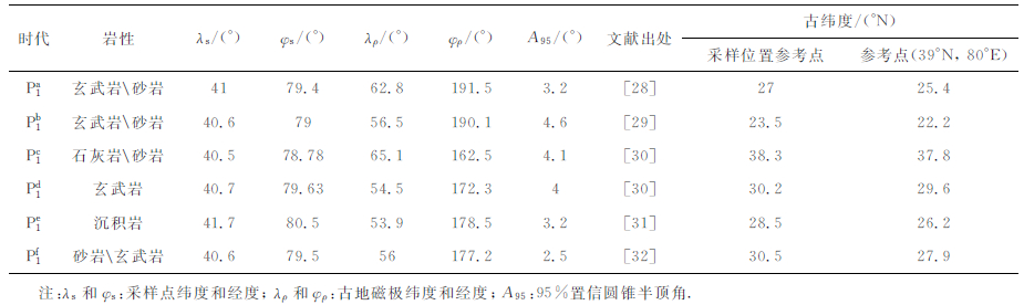
3 塔里木陆块早二叠世的经度 3.1 塔里木大火成岩省与LLSVPs在讨论经度之前,我们首先用古地磁数据(表 1)来限制塔里木陆块早二叠世(目前没有年龄精确到290 Ma的数据)的纬度.表 1数据中a、b、f采样岩性包含火山岩,d完全采自玄武岩,故数据a、b、d、f计算出的古纬度更能代表塔里木大火成岩省喷发时的纬度.结果表明,其早二叠世纬度在22.2°N-29.6°N之间(统一到参考点39°N,80°E),考虑到95%置信误差(A95)则为17.6°N-33.6°N(表 1).且早二叠世可认为未受到真极移影响[27].
|
|
表 1 塔里木陆块下二叠统古地磁数据 Table 1 Lower Permian paleomagnetic data of the Tarim Block, NW China |
核幔边界低速带已由多个地震波速度异常模型[33-41]获得,这里首先选择Torsvik等[1-4, 13-14]惯用的SMEAN模型[35]-1%波速等值线(图 1)进行塔里木大火成岩省290 Ma经度的讨论.
理论上,根据单个古地磁极重建的塔里木可以在任何经度位置上.参考点(39°N,80°E)早二叠世纬度范围(17.6°N-33.6°N)与SMEAN模型-1%等值线有5处相交或相切的位置(图 1),即若塔里木大火成岩省源自核幔边界,其喷发位置有这5种可能性.但290 Ma泛大陆主体部分(包括北美、格陵兰、波罗的、南美、非洲等陆块)已被确定处于非洲LLSVP之上[3, 14-15],故排除当时塔里木处在非洲LLSVP边缘之上的3种可能性(图 1).
剩下与太平洋LLSVP相关的2种可能性,考虑到与现今位置的距离以及现今板块的运动速率,塔里木大火成岩省喷发时最可能处于太平洋LLSVP的西边缘之上(图 1).该位置与现今位置的大圆距离(球面上最短点间距)约7780km(以39°N,80°E为参考点,下同),这段距离至少需要2.7cm/a的平均速率才能让塔里木陆块从早二叠世运移到现今位置.若塔里木大火成岩省源自太平洋LLSVP的东边缘(图 1),其与现今位置的大圆距离在11200~11950km之间,需至少3.9~4.2cm/a的平均速率.似乎这些速率值都在现今正常板块漂移速率范围(最大板块扩张速率约为15.4cm/a,位于现今31.02°S,111.92°W[43])内,但板块不可能总是沿着大圆圆弧漂移,实际过程复杂多变,所以如果早二叠世塔里木陆块位于太平洋LLSVP边缘之上,其漂移到现今位置所需的实际平均速率要大得多.再尝试Torsvik等[4, 13-14]常用的CASTLE[33]和KUO[34]模型,早二叠世的塔里木同样最可能与太平洋LLSVP西边缘相关.将290 Ma的塔里木大火成岩省置于太平洋LLSVP西边缘(SMEAN -1%等值线),得到其经度约158°E(图 1).
但是,根据第2部分大地构造背景,158°E是否正确,取决于当时哈萨克斯坦的规模.哈萨克斯坦早二叠世的确切规模虽仍未确定,但即便其规模比现今大,也不可能有超过10000km的跨度(图 1中塔里木与波罗的距离),所以,上述经度结果158°E不能与前人的地质结论相吻合.
3.2 塔里木大火成岩省与LSVP通过上述推理可以断定:塔里木大火成岩不可能与SMEAN模型-1%等值线圈定的两大LLSVPs相关.因此就有两种可能性:(1)塔里木大火成岩省并非源自核幔边界;(2)塔里木大火成岩省源自核幔边界,但现今的波速异常模型尚未能分辨出其核幔边界低速带位置.
前人研究表明,西伯利亚大火成岩省与SMEAN模型的-1%波速等值线也没有关联,而其下存在一个单独分布的、比LLSVPs规模小的LSVP[13].观察SMEAN模型的2850~2450km深处横波速度异常(图 1,2)可以发现:在非洲LLSVP的东侧附近有一处dVS≈-0.4%的LSVP(20°N,60°E),规模比其北边的与西伯利亚大火成岩省相关的LSVP(dVS=-0.5%[1])要小,正好处在塔里木(参考点39°N,80°E)早二叠世可能所处纬度(17.6°N-33.6°N)范围内,且没有被290 Ma泛大陆所覆盖.将塔里木(39°N,80°E,该点位于巴楚地区)放在该LSVP之上(图 1),与上述前人的地质结论完全没有冲突.若塔里木大火成岩省来自核幔边界,该LSVP就是其幔源的唯一可能.

|
图 2 早二叠世塔里木大火成岩省的唯一可能幔源(0°N,60°E) 底图是2850至2450 km深度的SMEAN横波速度异常模型[35]. Fig. 2 Onlypossible alternative as the plume generation zone of the~290 MaTarim LIP (20°N, 60°E) The background shear wave velocity anomalies (2850 to 2450 km depth) is the SMEAN model[35]. |
不仅2750km深处的横波速度异常(图 1,2)指示(20°N,60°E)之下存在LSVP,2850~2450km深度都显示290 Ma塔里木应位于该低速带之上(图 2).核幔边界低速带通常至少有500km的海拔(以核幔边界为水平面)[44-45],因此若2800km深度的低速带固定了3亿年[3, 13-14],2850~2450km深度3亿年来也不应有所变动,由这几个深度的现今低速异常分布仍具有很好的上下对应关系(图 2)即可看出.似乎当时的塔里木之下存在一低速高温柱状体.
3.3.2 与其它地震波速异常模型的对比虽然各种地震波速(包括横波和纵波)异常模型[33-41]所用的原始数据库和计算方法有所不同,但都在(20°N,60°E)区域之下的2900~2000km深度范围有明显的低速柱状体的存在(图 3).图 3从2800km深度水平切片和20°N纵向剖面综合展示了最新模型成果,并与本文塔里木290 Ma重建进行对比.每个模型都显示,在非洲LLSVP和太平洋LLSVP之间存在唯一一处明显的横向尺度超过1000km,海拔超过500km(以其底部深度为水平面)的LSVP,且本文给出的60°E位置(图 3和图 1)都合理地与该LSVP相对应.个别模型(SAW24B16[36]和TX2011[37])中,塔里木大火成岩省没有对应2800km深水平切片低速带边缘,但从剖面上就可以理解:该低速带在2800km深处范围很小,而在2000~2700km深度出现明显大范围的低速带.其余模型在2800km深度水平切片和20°N纵向剖面上与290 Ma的塔里木都合理匹配.

|
图 3 各种地震层析成像模型与本文重建的290 Ma塔里木陆块位置对比 6个横波[36-41]和2个纵波[39, 41]波速异常模型的平面图位于2800 km深度;剖面位于20°N纬线,显示下地幔(670~2900 km深度)异常,低速带以间隔为0.1的等值线显示-1. 0至-0.4 (仅HMSL-P06模型至-0.2)的dV (%)值.通过古地磁数据=47=来限定哈萨克斯坦二叠纪位于约30°N,其板块大小是根据现今已知的构造缝合带和古生物资料划分[17]的一个近似三角形区域.地震数据自美国地震学研究耳关合会(IRIS)网站(www. iris.edu/dms/products/emc/models/). Fig. 3 290 Ma (Early Permian) reconstruction of the Tarim Block during the Pangea assembly is plotted above the horizontal slices of 6 different S-wave velocity anomaly models and 2 different P-wave velocity anomaly models at ca. 2800 km depth 20°N profile of each tomography model, showing the seismic velocity anomalyof the lower mantle (670~2900 km), is put below the horizontal slice map with the same longitudinal extent. The whole low shear wave velocity areas are shown with 0.1 % contour intervals. The velocity contours range from-0.4% (-0.2 % for only HMSL-P06) at the outer contour to-1.0% at the inner contour. A paleomagnetic data published[47] from North Tianshan positions Kazakhstan at ca. 30°N in the Permian. The margins of Kazakhstan, delimited by the sutures and faunal data today[17], forma triangle-shaped tectonic domain. The tomography data is from the IRIS website (www. iris, edu/dms/products/emc/models/). |
其它未在文中展示的模型与上述结果一致,如MITP08纵波异常模型[46].根据不同横波模型和纵波模型得出的相同结果,本文认为(20°N,60°E)之下的LSVP是存在的,此结论不依赖于某个特定模型.
4 与前人古板块重建的比较Golonka[48]的显生宙全球古地理重建图中第14图幅(296~285 Ma),纬度上,本文与其塔里木重建一致.而对于泛大陆主体,纬度和经度都有5°以上的差别,因为与本文参考的泛大陆重建[15]相比,Golonka[48]未进行100 Ma之前的真极移校正. Blakey [49]的显生宙全球古地理图中的晚石炭世(310~300 Ma)幅,塔里木的纬度以及其与哈萨克斯坦的相对位置与本文的重建无矛盾,且中二叠世(270~260 Ma)图幅的塔里木较晚石炭世图幅向北漂移了几个纬度.Cocks和Torsvik[50]也给出了约300Ma塔里木陆块古位置,与本文结果相比,其纬度高大约4°,但也在本文计算出的早二叠世(17.6°N-33.6°N)范围(参考点39°N,80°E)内,所以无冲突;其经度无定量制约,但其塔里木和哈萨克斯坦相对的边缘仍为被动陆缘,与地质年代学证据得出的结论“塔里木与哈萨克斯坦至晚泥盆世-石炭纪早期就已发生陆陆碰撞[23]”不符,而该地质年代学结论与本文的重建相符.
经度上,上述前人的塔里木重建皆无定量制约,仅考虑了与哈萨克斯坦的相对位置,这一点与本文的重建无矛盾.在泛大陆的绝对位置已确定[15]的基础上,前人的早二叠世塔里木位置[48-50]都与20°N,60°E的LSVP邻近,加之众多事实支持塔里木大火成岩省的地幔柱成因,该LSVP很可能就是其幔源,而且在古纬度制约下合理的重建经度范围内(考虑到当时哈萨克斯坦的规模)找不到任何其它核幔边界低速带的存在(图 1-3).
5 结论(1)在塔里木大火成岩省源自核幔边界且其下地幔柱是径直延伸的假设之下,本文利用古地磁和幔源法,首次获得了塔里木大火成岩省的喷发位置约为20°N,60°E.经前人的地质结论验证,该方法应用于塔里木陆块早二叠世(约290 Ma)绝对位置的重建是有效而合理的.即使抛开假设和幔源法,仅基于古地磁与地质资料,当时塔里木与20°N,60°E下核幔边界低速带的空间相关性,结合前人的地幔柱成因证据,暗示大火成岩省与该低速带密切相关,即其很可能源自核幔边界.
(2)290 Ma塔里木重建位置与当时波罗的(泛大陆的东北部)之间有大约20°的经向距离(20°N线上),且这一空间距离和现今划分的哈萨克斯坦块体范围很接近,这样也就定量地制约了早二叠世哈萨克斯坦的经度范围.
(3)基于本文对塔里木陆块绝对位置的重建和前人对华南板块、西伯利亚大火成岩省的位置恢复,如果塔里木、峨眉山和西伯利亚大火成岩省都源自核幔边界,三者便喷发于不同的低速带边缘,即它们皆非同一幔源.而塔里木、西伯利亚大火成岩省的幔源可能皆为非洲LLSVP的分支.
致谢感谢浙江大学余星博士和励音骐博士在塔里木大火成岩省研究进展方面的讲解.感谢评审专家提出的宝贵建议.感谢编辑部所付出的辛劳和智慧.
| [1] | Burke K, Torsvik T H. Derivation of Large Igneous Provinces of the past 200 million years from long-term heterogeneities in the deep mantle. Earth Planet. Sci. Lett. , 2004, 227(3-4): 531-538. DOI:10.1016/j.epsl.2004.09.015 |
| [2] | Torsvik T H, Smethurst M A, Burke K, et al. Large igneous provinces generated from the margins of the large low-velocity provinces in the deep mantle. Geophys. J. Int. , 2006, 167(3): 1447-1460. DOI:10.1111/gji.2006.167.issue-3 |
| [3] | Torsvik T H, Steinberger B, Cocks L R M, et al. Longitude: Linking Earth's ancient surface to its deep interior. Earth Planet. Sci. Lett. , 2008, 276(3-4): 273-282. DOI:10.1016/j.epsl.2008.09.026 |
| [4] | Torsvik T H, Burke K, Steinberger B, et al. Diamonds sampled by plumes from the core-mantle boundary. Nature , 2010, 466(7304): 352-355. DOI:10.1038/nature09216 |
| [5] | Steinberger B, Torsvik T H. A geodynamic model of plumes from the margins of Large Low Shear Velocity Provinces. Geochem. Geophys. Geosys. , 2012, 13: Q01W09. |
| [6] | Yang S F, Li Z L, Chen H L, et al. Permian large volume basalts in Tarim basin [OL]. June 2006 LIP of the Month. Large Igneous Provinces Commission, 2006. http://www.largeigneousprovinces.org/06jun |
| [7] | Zhang C L, Li X H, Li Z X, et al. Permian layered intrusive complex in the Western Tarim Block, Northwestern China: Product of a ca. 275 Ma mantle plume?. J. Geol. , 2008, 116(3): 269-287. DOI:10.1086/587726 |
| [8] | 厉子龙, 杨树锋, 陈汉林, 等. 塔西南玄武岩年代学和地球化学特征及其对二叠纪地幔柱岩浆演化的制约. 岩石学报 , 2008, 24(5): 959–970. Li Z L, Yang S F, Chen H L, et al. Chronology and geochemistry of Taxinan basalts from the Tarim basin: evidence for Permian plume magmatism. Acta Petrologica Sinica (in Chinese) , 2008, 24(5): 959-970. |
| [9] | Zhou M F, Zhao J H, Jiang C Y, et al. OIB-like, heterogeneous mantle sources of Permian basaltic magmatism in the western Tarim Basin, NW China: Implications for a possible Permian large igneous province. Lithos , 2009, 113(3-4): 583-594. DOI:10.1016/j.lithos.2009.06.027 |
| [10] | 余星.塔里木早二叠世大火成岩省的岩浆演化与深部地质作用[博士论文].杭州:浙江大学地球科学系, 2009. Yu X. Magma evolution and deep geological processes of Early Permian Tarim Large Igneous Province [Ph. D. thesis] (in Chinese). Hangzhou: Earth Science Department of Zhejiang University, 2009. http://www.oalib.com/references/15761122 |
| [11] | 余星, 陈汉林, 杨树锋, 等. 塔里木盆地二叠纪玄武岩的地球化学特征及其与峨眉山大火成岩省的对比. 岩石学报 , 2009, 25(6): 1492–1498. Yu X, Chen H L, Yang S F, et al. Geochemical features of Permian basalts in Tarim Basin and compared with Emeishan LIP. Acta Petrologica Sinica (in Chinese) , 2009, 25(6): 1492-1498. |
| [12] | Tian W, Campbell I H, Allen C M, et al. The Tarim picrite-basalt-rhyolite suite, a Permian flood basalt from northwest China with contrasting rhyolites produced by fractional crystallization and anatexis. Contrib. Mineral. Petrol. , 2010, 160(3): 407-425. DOI:10.1007/s00410-009-0485-3 |
| [13] | Burke K, Steinberger B, Torsvik T H, et al. Plume generation zones at the margins of large low shear velocity provinces on the core-mantle boundary. Earth Planet. Sci. Lett. , 2008, 265(1-2): 49-60. DOI:10.1016/j.epsl.2007.09.042 |
| [14] | Torsvik T H, Smethurst M A, Burke K, et al. Long term stability in deep mantle structure: Evidence from the~300 Ma Skagerrak-Centered Large Igneous Province (the SCLIP). Earth Planet. Sci. Lett. , 2008, 267(3-4): 444-452. DOI:10.1016/j.epsl.2007.12.004 |
| [15] | Torsvik T H, Müller R D, van der Voo R, et al. Global plate motion frames: Toward a unified model. Rev. Geophys. , 2008, 46(3): RG3004. |
| [16] | 刘椿, 黄宝春, 谈晓冬. 东特提斯海洋中的一些离散块体. 地质科学 , 1994, 29(2): 129. Liu C, Huang B C, Tan X D. Paleogeographic position of North China, Yangtze and Tarim Blocks: some separate blocks in the Eastern Tethys Ocean. Scientia Geologica Sinica (in Chinese) , 1994, 29(2): 129. |
| [17] | Torsvik T H, Cocks L R M. Earth geography from 400 to 250 Ma: a palaeomagnetic, faunal and facies review. J. Geol. Soc. , 2004, 161(4): 555-572. DOI:10.1144/0016-764903-098 |
| [18] | Yang S F, Li Z L, Chen H L, et al. 40Ar/39Ar dating of basalts from Tarim Basin, NW China and its implication to a Permian thermal tectonic event. Journal of Zhejiang University-Science A , 2006, 7(Suppl. Ⅱ): 320-324. |
| [19] | Zhang D Y, Zhou T F, Yuan F, et al. Source, evolution and emplacement of Permian Tarim Basalts: Evidence from U-Pb dating, Sr-Nd-Pb-Hf isotope systematics and whole rock geochemistry of basalts from the Keping area, Xinjiang Uygur Autonomous region, northwest China. J. Asian Earth Sci. , 2012, 49: 175-190. DOI:10.1016/j.jseaes.2011.10.018 |
| [20] | Şengör A M C, Natal'in B A. Paleotectonics of Asia: fragments of a synthesis. // Yin A, Harrison M eds. The Tectonic Evolution of Asia. Cambridge: Cambridge University Press, 1996: 486-641. |
| [21] | 方大钧, 金国海, 姜莉萍, 等. 塔里木盆地古生代古地磁结果及其构造地质意义. 地球物理学报 , 1996, 39(4): 522–532. Fang D J, Jin G H, Jiang L P, et al. Paleozoic paleomagnetic results and the tectonic significance of Tarim Plate. Chinese J. Geophys. (Acta Geophysica Sinica) (in Chinese) , 1996, 39(4): 522-532. |
| [22] | Abrajevitch A, Van der Voo R, Bazhenov M L, et al. The role of the Kazakhstan orocline in the late Paleozoic amalgamation of Eurasia. Tectonophysics , 2008, 455(1-4): 61-76. DOI:10.1016/j.tecto.2008.05.006 |
| [23] | 蔡东升, 卢华复, 贾东, 等. 南天山蛇绿混杂岩和中天山南缘糜棱岩的40Ar/39Ar年龄及其大地构造意义. 地质科学 , 1996, 31(4): 384–390. Cai D S, Lu H F, Jia D, et al. 40Ar/39Ar dating of the ophiolite melange in Southern Tianshan and the mylonite in the southern rim of Center Tianshan and their tectonic significance. Scientia Geologica Sinica (in Chinese) , 1996, 31(4): 384-390. |
| [24] | Abrajevitch A, Van der Voo R, Levashova N M, et al. Paleomagnetic constraints on the paleogeography and oroclinal bending of the Devonian volcanic arc in Kazakhstan. Tectonophysics , 2007, 441(1-4): 67-84. DOI:10.1016/j.tecto.2007.04.008 |
| [25] | Görz I, Hielscher P. An explicit plate kinematic model for the orogeny in the southern Uralides. Tectonophysics , 2010, 493(1-2): 1-26. DOI:10.1016/j.tecto.2010.07.005 |
| [26] | 陈汉林, 杨树锋, 王清华, 等. 塔里木板块早-中二叠世玄武质岩浆作用的沉积响应. 中国地质 , 2006, 33(3): 545–552. Chen H L, Yang S F, Wang Q H, et al. Sedimentary response to the Early-Mid Permian basaltic magmatism in the Tarim plate. Geology in China (in Chinese) , 2006, 33(3): 545-552. |
| [27] | Steinberger B, Torsvik T H. Absolute plate motions and true polar wander in the absence of hotspot tracks. Nature , 2008, 452(7187): 620-623. DOI:10.1038/nature06824 |
| [28] | 程国良, 白云虹, 李永安. 新疆乌什-阿克苏地区下二叠统地层的古地磁研究. 地震地质 , 1983, 5(4): 12. Cheng G L, Bai Y H, Li Y A. Palaeomagnetism of Lower Permian in the Wushi-Aksu area of Xinjiang. Seismology and Geology (in Chinese) , 1983, 5(4): 12. |
| [29] | Bai Y H, Chen G L, Sun Q G, et al. Late Paleozoic polar wander path for the Tarim platform and its tectonic significance. Tectonophysics , 1987, 139(1-2): 145-153. DOI:10.1016/0040-1951(87)90203-4 |
| [30] | Sharps R, McWilliams M, Li Y P, et al. Lower Permian paleomagnetism of the Tarim block, northwestern China. Earth Planet. Sci. Lett. , 1989, 92(3-4): 275-291. DOI:10.1016/0012-821X(89)90052-6 |
| [31] | Fang D J, Chen H L, Jin G H, et al. Late Paleozoic and Mesozoic paleomagnetism and tectonic evolution of the Tarim terrane. // Wiley T J ed. Circum-Pacific Council for Energy and Mineral Resources, Earth Science Series. Terrane Analysis of China and the Pacific Rim. Houston, Texas, 1990: 251-256. |
| [32] | 方大钧, 金国海, 陈汉林等.塔里木板块北缘晚古生代、中生代古地磁结果与构造演化的初步探讨. //贾润胥主编.中国塔里木盆地北部油气地质研究(第2辑), 构造与油气.武汉:中国地质大学出版社, 1991: 96-104. Fang D J, Jin G H, Chen H L, et al. Preliminary approach to Late Paleozoic-Mesozoic geomagnetism and tectonic evolution in north margin of Tarim Plate. // Jia R X ed. Research of Petroleum Geology of Northern Tarim Basin in China, Structural and Petroleum Geology (in Chinese). Wuhan: China University of Geosciences Press, 1991: 96-104. |
| [33] | Castle J C, Creager K C, Winchester J P, et al. Shear wave speeds at the base of the mantle. J. Geophys. Res. , 2000, 105(B9): 21543-21557. DOI:10.1029/2000JB900193 |
| [34] | Kuo B Y, Garnero E J, Lay T. Tomographic inversion of S-SKS times for shear velocity heterogeneity in D″: Degree 12 and hybrid models. J. Geophys. Res. , 2000, 105(B12): 28139-28157. DOI:10.1029/2000JB900334 |
| [35] | Becker T, Boschi L. A comparison of tomographic and geodynamic mantle models. Geochem. Geophys. Geosys. , 2002, 3(1): 1003. |
| [36] | Mégnin C, Romanowicz B. The three-dimensional shear velocity structure of the mantle from the inversion of body, surface and higher-mode waveforms. Geophys. J. Int. , 2000, 143(3): 709-728. DOI:10.1046/j.1365-246X.2000.00298.x |
| [37] | Grand S P. Mantle shear-wave tomography and the fate of subducted slabs. Phil. Trans. Math. Phys. Eng. Sci. , 2002, 360(1800): 2475-2491. DOI:10.1098/rsta.2002.1077 |
| [38] | Panning M, Romanowicz B. A three-dimensional radially anisotropic model of shear velocity in the whole mantle. Geophys. J. Int. , 2006, 167(1): 361-379. DOI:10.1111/gji.2006.167.issue-1 |
| [39] | Houser C, Masters G, Shearer P, et al. Shear and compressional velocity models of the mantle from cluster analysis of long-period waveforms. Geophys. J. Int. , 2008, 174(1): 195-212. DOI:10.1111/gji.2008.174.issue-1 |
| [40] | Panning M P, Leki? V, Romanowicz B A. Importance of crustal corrections in the development of a new global model of radial anisotropy. J. Geophys. Res. , 2010, 115(B12): B12325. DOI:10.1029/2010JB007520 |
| [41] | Simmons N A, Forte A M, Boschi L, et al. GyPSuM: A joint tomographic model of mantle density and seismic wave speeds. J. Geophys. Res. , 2010, 115(B12): B12310. DOI:10.1029/2010JB007631 |
| [42] | Wessel P, Smith W H F. Free software helps map and display data. Eos Trans. AGU , 1991, 72(41): 441, 445-446. |
| [43] | DeMets C, Gordon R G, Argus D F. Geologically current plate motions. Geophys. J. Int. , 2010, 181(1): 1-80. DOI:10.1111/gji.2010.181.issue-1 |
| [44] | Ni S, Tan E, Gurnis M, et al. Sharp Sides to the African Superplume. Science , 2002, 296(5574): 1850-1852. DOI:10.1126/science.1070698 |
| [45] | He Y M, Wen L X. Structural features and shear-velocity structure of the "Pacific Anomaly". J. Geophys. Res. , 2009, 114(B2): B02309. |
| [46] | Li C, van der Hilst R D, Engdahl E R, et al. A new global model for P wave speed variations in Earth's mantle. Geochem. Geophys. Geosys. , 2008, 9(5): Q05018. |
| [47] | Bazhenov M L, Collins A Q, Degtyarev K E, et al. Paleozoic northward drift of the North Tien Shan (Central Asia) as revealed by Ordovician and Carboniferous paleomagnetism. Tectonophysics , 2003, 366(1-2): 113-141. DOI:10.1016/S0040-1951(03)00075-1 |
| [48] | Golonka J. Cambrian-Neogene Plate Tectonic Maps. Cracow: Wydawnictwa Uniwersytetu Jagiellońskiego, 2000 . |
| [49] | Blakey R. Sedimentation, Tectonics, and Paleogeography of Asia [OL]. 2010. http://cpgeosystems.com/paleogeographic_asia.html |
| [50] | Cocks L R M, Torsvik T H. Siberia, the wandering northern terrane, and its changing geography through the Palaeozoic. Earth Sci. Rev. , 2007, 82(1-2): 29-74. DOI:10.1016/j.earscirev.2007.02.001 |