 2013, Vol. 56

2. 中国地震局兰州地震研究所, 兰州 730000;
3. 中国地震局地质研究所 活动构造与火山重点实验室, 北京 100029;
4. 中国地震灾害防御中心, 北京 100029
 , YUAN Dao-Yang2, HE Wen-Gui2, MIN Wei3, REN Zhi-Kun1, LIU Xing-Wang2, WANG Ai-Guo2, XU Chong3, GE Wei-Peng1,2, LI Feng3,4
2. Lanzhou Institute of Seismology, China Earthquake Administration, Lanzhou 730000, China;
3. Key Laboratory of Active Tectonics and Volcano, Institute of Geology, China Earthquake Administration, Beijing 100029, China;
4. China Earthquake Disaster Prevention Center, Beijing 100029, China
据中国地震台网中心测定(CENC,http://www.csndmc.ac.cn[201-09-25]),
甘东南地区位于两条区域性大断裂-东昆仑断裂(F1)和西秦岭北缘断裂(F2)围限中(图 1),由迭部-白龙江断裂带(F3)、光盖山-迭山断裂带(F4)、临潭-宕昌断裂带(F5)、文县-康县-略阳断裂带(F6)、康县-略阳断裂带(F7)、两当-江洛断裂(F8)、礼县-罗家堡断裂(F9)等多条规模较大的断裂(带)共同组成了该地区复杂的“V”字型构造体系[7-11].受青藏高原向北东挤压作用的影响,甘东南地区新构造运动和地震活动强烈,褶皱分布广泛[12-14],强烈的构造作用造就了复杂的地形地貌特征:沟谷发育、切割强烈、山势陡峻、相对高差较大,地形高差可达500~3000 m[15-16].另外,该地区历史上曾发生过1654年天水南和1879年武都南两次8级大地震[7, 12, 15-17],同时也有公元前186年甘肃武都6~7级地震、143年甘谷7级地震、734年天水7级地震、1573年岷县6¾级地震、1837年岷县北6级地震、842年碌曲7~7½级地震等数次历史地震发生[7-11, 17-20],近年来也曾发生多次破坏性地震[8, 19].

|
图 1 甘东南及邻区主要活动构造与地震.(a)青藏高原及周边地区地貌图,图中短线框为图b的范围;(b)甘东南及邻区主要活动构造图像及地震(断裂资料主要来源于文献[4, 10, 11, 12],综合后略做修改),图中绿色短线框为图 3的范围,蓝色点线框为图 7剖面的所切位置 Fig. 1 Active tectonics and earthquakes of the southeastern Gansu and its adjacent regions.(a) Index map including the shaded DEM of the Tibet plateau and its adjacent regions, the dashed frame shows the range of Fig.b.(b) Map of the southeastern Gansu and its adjacent regions with main active tectonics and earthquakes.These faults data have been modified after Yuan (2003), Yuan et al (2004), Zheng et al (2005) and Yu et al (2012).The green dashed frame shows the range ofFig. 3.The blue dotted frame shows the region in Fig. 7 |
本文在区域地震构造新活动特征、构造环境、历史地震及现代地震特征等的总结和分析基础上,结合本次岷县-漳县地震的应急科学考察,以及震源机制解和区域地球物理资料,探讨了岷县-漳县地震的孕震环境和机制,同时结合区域动力学特征的讨论对该地区潜在的中强震危险性进行分析.
2 区域构造新活动及构造转换甘东南地区复杂的构造体系由多条活动断裂组成(图 1),从区域构造图像上看,在东昆仑断裂(F1)和西秦岭北缘断裂(F2)之间构成一个巨大的左旋岩桥区[1, 13, 21-27],位于岩桥区内的一系列小型逆冲兼左旋走滑断裂是两条主要控制性边界断裂之间构造转换过渡的关键.前人的研究中给出了该地区主要断裂的运动学定量结果,对于主要的控制性断裂—东昆仑断裂,前人通过河流阶地及断错地貌的研究认为其左旋走滑速率约为10 mm/a[28-31],向东有逐渐减弱趋势,到了玛曲以东一带仅为2 mm/a[30],近年来也有学者指出,东昆仑断裂与塔藏断裂相连,一直向东延伸,塔藏断裂上的左旋走滑速率为1~1.5 mm/a,同时具有少量的逆冲分量[31],而北侧的西秦岭北缘断裂其左旋走滑速率只有2~3 mm/a[5].
位于两条控制性断裂之间起构造转换作用的断裂,近年来的研究也给出了各自的定量运动特征(图 2).通过活动断裂填图得到的迭部-白龙江断裂带(F3)东段的白龙江北缘断裂晚第四纪以来的逆冲速率为0.7 mm/a,白龙江南缘断裂晚第四纪逆冲速率为0.38±0.12 mm/a,走滑速率为1.37±0.10 mm/a[32];俞晶星等[12]通过不同地貌面上断错位移的测量和地貌面定年获得了光盖山-迭山断裂(F4)晚第四纪以来的垂直滑动速率为0.49±0.08~1.15±0.28 mm/a,左旋走滑速率为0.51±0.13 mm/a;袁道阳等[7]曾给出临潭-宕昌断裂(F5)的走滑速率为2~2.5 mm/a,这一结论只是根据东昆仑断裂与西秦岭断裂的滑动速率差异估计得出的,并未进行定量研究,最新研究的结果仅为1 mm/a左右[32];韩竹军等[17]得到礼县-罗家堡断裂(F9)的左旋走滑速率为0.95 mm/a;贾伟等[33-34]得到的康县-略阳断裂(F7)中段的晚更新世以来左旋走滑速率自西向东增大,从0.35 mm/a增大至1.39 mm/a,全新世以来左旋走滑速率从0.68 mm/a增大至1.48 mm/a,东段晚更新世以来平均左旋滑动速率为1.06 mm/a;对于两当-江洛断裂(F8)活动断裂地质填图得到的左旋走滑速率为0.5~1.5 mm/a,逆冲速率为0.5~1 mm/a[32];文县-康县-略阳断裂带(F6),前人的研究主要集中于其南段发生的1879年武都南8级地震[14],根据近几年地质填图的结果,该断裂全新世以来左旋滑动速率为2~2.5 mm/a[32].

|
图 2 甘东南地区主要断裂走滑速率及区域构造转换关系.图中断裂及运动模式据文献[4, 8, 11]修改;滑动速率资料来源于文献[5, 7, 12, 28-34] Fig. 2 Strike-slip rate and relation on tectonic transition of NWW fault in southeastern Gansu province.In Fig. 2, active fault and kinematic pattern have been modified after Yuan et al (2002), Yuan (2003) and Zheng et al (2005).Strike-slip rates of main fault from Li (2005), Yuan et al (2007), Yu et al (2012), Li (2009), Kriby et al (2007), He et al (2006), Jia (2012), Jia et al (2012), Liu (2012) and Ren et al (2013) |
对于断裂滑动速率等运动学参数所反映区域构造变形特征,根据Zheng等[35]总结的青藏高原周边地区主要走滑断裂上滑动速率的转换模式,甘东南地区的这些近于平行的断裂及其与这些断裂组成“V”字型的断裂系统的其他断裂,通过各条断裂相对较低的滑动速率(包括了走滑和逆冲),以及断裂之间隆起山脉及不同时代盆地的变形,共同承担了自东昆仑断裂向西秦岭北缘断裂过渡过程中运动分量吸收和转换(图 2).袁道阳等[4, 7, 11]认为东昆仑断裂与西秦岭北缘断裂走滑速率的不一致主要是被包括临潭-宕昌断裂、光盖山-迭山断裂带、迭部-白龙江断裂带等一系列断裂的走滑变形吸收所致.而通过对青藏高原东北缘的GPS观测结果及第四纪滑动速率的综合分析,Duvall等[36]认为东昆仑断裂的变形并非往东传递,而是向北传递到了海原断裂,但海原断裂并没有完全吸收东昆仑断裂所有的变形.另外,Duvall等[6]还通过低温热年代学得出的结果显示西秦岭北缘断裂早在始新世就已经开始活动,在高原整体变形过程中起到了重要作用,吸收和转换了东昆仑断裂往北传递过程中的部分运动分量.
3 临潭-宕昌断裂的几何结构与活动特征临潭-宕昌断裂作为甘东南构造转换和变形传递过程中的一条重要断裂,其几何展布,新活动性和运动特征对讨论地震的孕育有着至关重要的作用.该断裂由多条规模不等、相互平行或斜接的次级断裂组合而成,断裂带影响宽度范围在5~10 km (图 3),在岷县东南断裂仅为一支,延至宕昌以南.断裂的总体性质为地表可见以向南逆冲为主,呈北西西-北西向展布,倾向北东,倾角50°~70°,局部陡立或南倾,具左旋走滑分量,因此,在不同的断裂段上活动性差异较大.大地构造研究方面的资料显示,该断裂形成于海西期,在其后的构造运动中曾有过多次强烈活动,切割并断错了不同时代的地层,破碎带宽达数十米到百余米,带中见有断层角砾岩及断层泥,局部地层有动力变质现象[3, 13, 23-24].在航卫片上断裂影像清晰,两侧色调差异显著,一般表现为南浅、北深的特点.

|
图 3 临潭-宕昌断裂几何展布及新活动特征 (a)临潭-宕昌断裂分段几何结构,图中地层资料简化于1:200000地质图1),烈度等值线来源于http://www.cea.gov.cn/publish/dizhenj/464/478/20130724133721239856586/index.html[2013-09-25];(b)断裂中段北支断错山脊及断层槽谷(镜向NW);(c)断裂中段北支断层挤压脊(镜向E);(d)断裂中段南支断层地貌(镜向E);(e)断裂东段断层附近冲沟裂点(镜向E);(f)岷县北奈子沟断层剖面(镜向E). Fig. 3 Activity and geometric distribution on Lintan-Dangchang fault (a) Geometric distribution on Lintan-Dangchang fault.Data of stratum have been simplified from geology map1).The contour of the seismic intensity of Minxian-Zhangxian earthquake come from http://www.cea.gov.cn/publish/dizhenj/464/478/20130724133721239856586/index.html[2013-09-25]. (b) Offset ridge and fault trough on northern branch fault of middle segment (View to NW); (c) Extrusion ridge on northern branch fault of middle segment (View to E); (d) Fault landform on southern branch fault of middle segment (View to E); (e) Knick point nearby eastern segment of fault (View to E); (f) Fault section of Naizigou at northern of Minxian (Viewto E). |
1) 陕西省地质局,1:200000岷县幅(I-48-15)区域地质图,1970;甘肃省地质局,1:200000卓尼幅(I-48-14)区域地质图,1973;甘肃省地质局,1:200000临潭幅(I-48-8)区域地质图,1970;甘肃省地质局,1:200000合作幅(I-48-7)区域地质图,1971.
大量的地貌调查和研究认为,临潭-宕昌断裂带各断裂段活动性差异较为明显,且每段内也呈现出断裂活动的不均匀性(图 3).各断裂段的活动性为:西段(合作断裂段)北支(F1-1)活动性较弱,为早更新世或前第四纪活动断裂,西段(合作断裂段)南支(F1-2)活动不均匀,最西端活动性较差,为早中更新世活动,东端为晚更新世活动;中段(临潭断裂段)相对较活动,北支(F2-1)为全新世早期活动,其活动性在整个断裂带中最强,南支(F2-2)为早中更新世-晚更新世早期活动;东段(岷县-宕昌断裂段)的主支断裂(F3-1)活动性较弱,断裂段主要部分为前第四纪或早更新世活动,仅有少量地段呈现出中-晚更新世有过活动的特征,其北缘的两条次级断裂中最北边的一条(F3-3)可能在第四纪晚期(全新世)有复活动的迹象(图 3),沿洮河的一条断裂(F3-2)最新活动时间应为早中更新世,而其最南端的斜接断裂活动时间与主干断裂一致,为第四纪早期或前第四纪.可以看出,临潭-宕昌断裂总体上由多条次级断裂组成,各断层段长度不同,总体上以平行和斜接为主,其活动性的差异说明各断裂段在新构造运动过程中应力集中不均匀,不具备不同断裂段同时破裂和应力集中的可能,出现多个受力不均一点,这也是近几年及历史上该地区中强地震多发的一个主要原因.
4 岷县-漳县MS6.6地震基本特征震后多个机构通过快速反演给出的岷县-漳县MS6.6级强烈地震的震源机制解结果(表 1),显示震源过程以逆冲为主,兼具左旋走滑性质,这与地质调查的结果基本一致.震后灾害调查所给地震烈度等值线也反映了一个长轴较长的椭圆形区域,Ⅷ度极震区长轴长约40 km,短轴长约20 km (http:// www.cea.gov.cn/publish/dizhenj/464/478/2013 0724133721239856586/index.html[2013-09-25]),Ⅷ度区长轴方向与该断裂东段走向一致,说明本次地震与临潭-宕昌断裂(或是其中的一支)关系密切(图 3a).
|
|
表 1 不同研究机构给出的岷县-漳县MS6.6级地震震源机制解 Table 1 Focal mechanism solutions of Minxian-Zhangxian Earthquake from different research unit |
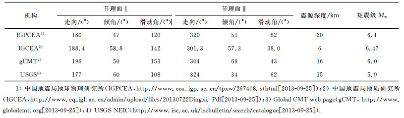
图 4中显示了震后科学考察极震区的震害分布,可以明显看出,极震区严重震害点基本上沿茶固滩、马家沟、文斗、车路、永光、永星、拉路、朱麻滩一线分布(图 4a),地貌上表现出明显的地形变化界线,沿线不仅本次地震中滑坡、崩塌呈带状分布,而且也是一个带状分布的老滑坡带.从图 4b可以看出,该条带正好位于临潭-宕昌断裂北侧分支断层控制的古近纪盆地中,在北侧二叠纪板岩、砂岩、泥岩等向南逆冲于古近纪砾岩及砂砾岩之上,断层附近古近纪沉积厚度明显增厚(图 4(b,c)).条带状震害分布的西端,茶固滩-马家沟正好位于第三纪盆地中,本次地震形成多处滑坡和乡间公路边坡崩塌(图 5(a,b)).在车路-永光-永星-拉路一带,滑坡和震害较重区地貌有明显的线性地貌特征(图 4a),震害以滑坡、崩塌、黄土陷落等为主要特征,其中由于地震的强烈震动还引起了一处规模较大的“干泥石流“(没有或很少有水的作用,主要是地震瞬间震动引起黄土顺沟向坡下滑动),同时规模较大的几处滑坡也位于这几个村庄附近,实地调查发现该区域上部为十余米或更厚的黄土,下部为基岩,也就是两套地层分界线,同时也是第三纪小型盆地的边界,因此盆地内地震震害可能存在放大作用,同时黄土地基也是造成震害的重要诱因(图 5(c,d,e,f)).东端拉路-朱麻滩一带,可见明显的断层线性地貌特征,震害也主要沿地貌变化,呈带状分布(图 5g),在朱麻滩村见次级断层剖面(图 5h),为二叠系炭质板岩逆冲于古近纪砾岩之上,但本次地震该处断层没有发生明显错动,仅表现为断裂南侧分布的滑坡与崩塌.综合认为在该地质灾害分布较严重的地区,民居房屋由于建筑质量、山坡地形、黄土地基、地质条件等的综合影响,破坏较为严重,地震引起的地质灾害严重是造成破坏的主要原因,这在以前该地区在中强地震中也曾表现出如此特征[8, 19].通过对各主要断裂分支的现场调查,没有发现本次地震产生的地震地表破裂.

|
图 4 岷县-漳县地震极震区附近影像及地质特征 (a)极震区附近卫星影像(资料来源于Googleearth);(b)极震区附近地质特征(根据1:200000地质图资料简化及修改)2);(c)横穿极震区的地质剖面,根据实地调查及地质资料编绘. Fig. 4 Map of image and geology of severely damaged area in Minxian-Zhangxian earthquake (a) Satellite image of severely damaged area (Image data from Google earth); (b) Geology map of severely damaged area (Data have been simplified from geology map2)); (c) Cross section of severely damaged area, data from field investigation and geology map. |
2)陕西省地质局.1:200000岷县幅(I-48-15)区域地质图,1970.

|
图 5 岷县-漳县地震极震区主要震害及地貌特征 (a)茶固滩东北黄土滑坡;(b)车路村西黄土崩塌及滑坡;(c)永光村滑坡,掩埋4户人家,12人死亡;(d)永光村地震引起的干泥石流;(e)永星村一带的黄土陷坑;(f)拉路村一带黄土边坡崩塌;(g)朱麻滩一带断层地貌,严重震害基本沿地貌线分布;(h)朱麻滩村附近断层剖面. Fig. 5 Geomorphology and related disaster of severely damaged area in Minxian-Zhangxian earthquake (a) Loess landslide at northeastern of Chagutan village; (b) Loess landslide and collapse at western of Chelu village; (c) Large landslide at Yongguan village.The landslide buried 4 homes and killed 12 people; (d) Dry debris flow near Yongguan village; (e) Loess pitfall at Yongxing village; (f) Loess collapse at Lalu village; (g) Fault geomorphology near Zhumatan village.There are relatively serious disaster near fault zone; (h) Fault section at Zhumatan village. |
图 3中显示,临潭-宕昌断裂的主支断裂(F3-1)位于本次地震的南部,该断层距离本次地震的极震区和仪器震中位置约8~10 km,基本沿洮河南岸延伸到洮河转弯处,然后沿岷县县城北侧向南东延伸,本次地震沿该断层没有较为严重的震害,滑坡、崩塌也仅为较小规模,说明本次地震可能为该断裂带上多个次级断层段共同作用的结果.
5 历史和现代中强地震与构造的关系前已述及,甘东南地区历史上就有多次地震发生(图 1),特别是其北边的西秦岭北缘断裂带附近和南部的武都一带,历史上多有7级以上地震发生[7, 14, 17-18, 20].对于甘东南地区起构造转换作用的临潭-宕昌断裂,历史上也曾发生过多次6~7级地震:如1573年岷县6¾级地震[9]、1837年岷县北6级地震[10]、842年碌曲7~7½级地震[18, 20]等,同时近十年以来,该地区也发生了多次5级以上地震[8, 19],小地震活动也较为频繁[32].这些中强地震虽然没有形成明显的地震地表破裂带,但其震害分布与临潭-宕昌断裂的某些段落关系密切,特别是烈度等值线的长轴方向,基本与断裂走向一致(图 6).

|
图 6 历史地震与现代地震极震区分布特征(历史地震烈度资料来自文献[8, 9, 10, 18, 19, 20];本次地震烈度等值线来自http://www.cea.gov.cn/publish/dizhenj/464/478/20130724133721239856586/index.html[2013-09-25]) Fig. 6 Severely damaged area of historical and modern earthquakes along Lintan-Tanchang fault.The data for the contour of theseismic intensity of historical and modern earthquakes come from Ref.[8-10, 18-20].The contour of the seismic intensity of Minxian-Zhangxian earthquake come from http://www.cea.gov.cn/publish/dizhenj/464/478/20130724133721239856586 /index.html[2013-09-25]. |
在前期的研究中,我们利用活断层工作方法[37],结合历史资料记载和历史地震烈度表的规定,对几次主要的历史地震进行了等烈度线的重新确定,虽然该地区现在还相对比较贫穷,但人类活动历史较长,一直是中原汉族和少数民族的混居地,有多种少数民族文字对该地区破坏性地震进行了记载[9, 10, 18, 20],因此在对历史地震重新考证时,充分收集了这些资料,以使历史地震的位置更加准确,而现代地震的烈度等值线,参照最新发表的成果确定,虽然历史地震与现代地震烈度确定有一定的差异,但也能反映其构造活动特征的一些信息[8, 19].对于842年碌曲地震与临潭-宕昌断裂西段的关系密切,根据其中历史记载的“水泉涌,岷山崩,洮水逆流三日”以及死伤记录的描述[18, 20],其极震区烈度可能达到Ⅸ度左右,该次地震震级可定为7~7½级,由于该地区历史上属于人迹较少地区,因此仅根据历史地震资料确定了其大概的极重灾区范围.而几次主要的历史地震和近年来的多次现代地震都发生在临潭-宕昌断裂的东段,1573年的岷县6¾级地震[9]和1837年岷县北6级地震[10]等的极重灾区分布与临潭-宕昌断裂带东段断层展布大致相吻合,断裂东段应为这两次地震的发震构造.2003年发生的岷县5.2级地震[8]、2004年岷县卓尼5.0级地震[19]的位置相对较近,其Ⅶ度及以上烈度区长轴方向基本符合临潭-宕昌断裂东段的走向,且正好位于该断裂主支与北侧次级断裂分支之间的断层带内,而2013年7月22日的岷县-漳县6.6级地震的Ⅶ度以上重灾区,更是完全与断裂的展布紧密相关(图 6),说明临潭-宕昌断裂复杂的组合特征对多次历史和现代中强地震的孕育起着至关重要的作用.而有历史记载的历史地震多集中在东段可能说明临潭-宕昌断裂各段新活动存在明显的差异,而根据历史地震和现代地震震级普遍为中等强度地震可以判定,断裂不仅在地表上存在明显的分段和较宽的断层带,其深部结构上也可能存在不同的分支[38-41],与地质调查中存在多条规模不等的次级断裂组成较宽的断层带是相符的(图 3,6).
我们综合历史地震和现代地震的活动可以判定,临潭-宕昌断裂的分段活动特征明显,不同段落的地震活动规模及频率差异较大,但综合考虑,由于断裂的中段历史及现代地震活动较少,也没有震级较大的地震发生,而从现今地貌特征判断该断裂段又是临潭-宕昌断裂带晚第四纪活动特征最为明显的一段,存在明显的中强地震破裂空区(图 6),因此未来该断裂段的中强震危险性值得关注.
6 区域构造孕震机制的分析与讨论从图 1及图 2中甘东南地区整体构造图像和运动学图像中可以看出,在区域上,南部的东昆仑断裂带(F1)与北部的西秦岭北缘断裂带(F2)之间存在过渡递变关系,东昆仑断裂(F1)最东端在若尔盖一带逐渐向南东偏移,然后与塔藏断裂斜接;而向东北方向扩展过程中,断裂出现分叉现象,共发育了北西西向断裂三组,分别是:迭部-白龙江断裂带(F3)、光盖山-迭山断裂带(F4)、临潭-宕昌断裂带(F5),最后逐步过渡到西秦岭北缘断裂带(F2)上,而三条中间的过渡断裂(F3、F4、F5)在构造运动转换过程中起着重要作用(图 2).从目前对临潭-宕昌断裂带的研究可以看出,断裂整体表现为高角度的向南逆冲性质(图 3),局部表现出左旋走滑,但走滑速率较低.另外,前面的讨论和总结中已经说明该断裂上中强地震的发生较为频繁,而其南部的两条断裂(F3、F4)以高角度向北逆冲为主,表现的是这些北西向断裂在构造演化过程中向北东方向扩展特征,而几条断裂的强活动段落和中强地震活动也将由断裂的整体逐步转换到断裂中部,乃至其扩展过程在其突出部分前缘形成的新的断裂上.因此,临潭-宕昌断裂带在整个区域上所起的作用是构造转换和区域应力的重新分配,这也是近些年该地区中小地震频发的一个重要因素.
从整个青藏高原东北部的变形分析可知,由于印度板块与欧亚板块的碰撞及其后印度板块向北楔入作用所引起的挤压应力是造成高原东北部隆升的主要原因[27, 42-46],也是东昆仑构造带及西秦岭北缘构造带发生向北为主的逆冲推覆运动的主要动力来源[6, 30, 36].根据王志才等[43-44]对西秦岭北缘断裂的陇西、武山等新生代盆地研究结果表明,西秦岭北缘断裂由先期的挤压逆冲为主在新生代后期逐渐转变为走滑为主要特征,并形成了向两侧扩展的“花状构造”.同样地,据Tapponnier等[27]的研究表明,东昆仑断裂带主要形成一个向北扩展的单侧发育的“花状构造”,也就是表现出明显的向北扩展特征.我们综合前人在构造特征[5-8, 11, 30, 36]、新生代沉积地层及盆地演化[47-48]、深部地球物理探测[38-41]、GPS速率场的变化[49-52]、地震学[53-55]等研究和探测结果,将横切甘东南地区的主要断裂构造的深浅构造关系表示于图 7中,可以看出,青藏高原向北东方向的挤压使区域上以两大主要断裂构造为主的甘东南地区发生了复杂的构造变形:南部与东昆仑断裂(F1)相邻的迭部-白龙江断裂带(F3)及光盖山-迭山断裂带(F4)构造变形和运动转换的动力来源是东昆仑断裂在新生代以来的向北东扩展和推挤;北部的临潭-宕昌断裂带(F5)的先期形成主要是受与其关系密切的西秦岭北缘断裂(F2)影响,而后期的变形不仅与西秦岭北缘断裂(F2)向两侧的扩展有关,也受到了来自东昆仑断裂(F1)向北的扩展和推挤的影响.因此在临潭-宕昌断裂带周边形成复杂的应力构造环境,GPS速率场的变化也反映了一个整体向北东扩展、同时局部旋转变形[49-52]的特点,而临潭-宕昌断裂带上中强地震的活动也主要是由于这种运动特征引起的断裂带附近的应力集中所致,而断裂的分段多及复杂的深、浅几何结构是该断裂带上主要以中等强度地震为主的原因之一.

|
图 7 横穿甘东南地区的构造变形剖面图.图中的实线为根据地球物理[38-41]、地质资料[11, 27, 47-48]、地震学[53-55]等方面资料综合确定的断层位置,虚线表示推测断层位置 Fig. 7 Schematic diagram presenting postulated model of tectonic deformation at the southeastern of Gansu.The red solid line showing fault traces summarized a lot of data from geophysics[11, 27, 47-48], tectonic geology (Tapponnier et al., 2001; Yuan, 2003;Wang et al., 2006;2012) and seismology [53-55].The dashed lines are inferred faults at depth |
甘东南地区是著名的南北地震带及青藏高原东北部的重要组成部分,其复杂多样的构造变形模式和构造活动特征是该地区中强地震孕育和发生的重要原因,两条主要边界断裂带(东昆仑断裂和西秦岭北缘断裂)和二者之间的完成区域构造运动转换的其他断裂带,共同组成了该地区复杂的构造图像. 2013年7月22日发生在甘肃岷县-漳县的MS6.6级地震正是位于该地区一条主要断裂---临潭-宕昌断裂带上,该断裂带附近不仅现代地震活动频繁,而且历史上也发生过多次中强地震,历史和现代地震以及本次地震的严重破坏区正好位于临潭-宕昌断裂东段多条次级断层组成的断裂带内.断裂带几何结构复杂,由多条平行或是斜接的、规模相对较小的次级断层组成,且存在明显的分段不均匀活动,而中强地震的频繁发生也说明该断裂各段之间既相互关联又相互影响.从区域构造的几何特征及运动学特征分析,青藏高原东北部东昆仑断裂的向北挤压和向东的运动是该地区构造应力集中的主要动力,而西秦岭北缘断裂走滑及向南北两侧逆冲“花状构造”是临潭-宕昌断裂带上中强地震频繁发生的重要动力因素.临潭-宕昌断裂带东段的频繁地震可能会引起其中段和西段的应力调整,从而触发震级相当的地震发生,因此该断裂中段的地震危险性有增强的趋势.
致谢感谢中国地震局甘肃岷县-漳县地震现场指挥部在野外工作过程中提供的支持;感谢中国地震局地质研究所张培震研究员给予的指导和讨论;感谢中国地震局地质研究所张会平博士和王伟涛博士在DEM处理和构造变形模式讨论方面的帮助;感谢两位审稿人对本文提出的宝贵意见和建议,促进了论文的完善和成熟.
| [1] | 张国伟, 孟庆任, 赖绍聪. 秦岭造山带的结构构造. 中国科学(B辑) , 1995, 25(9): 994–1003. Zhang G W, Meng Q R, Lai S C. Structure of the Qinling orogen. Science in China (Series B) (in Chinese) , 1995, 25(9): 994-1003. |
| [2] | 张国伟, 郭安林, 刘福田, 等. 秦岭造山带三维结构及其动力学分析. 中国科学(D辑) , 1996, 26(Suppl.): 1–6. Zhang G W, Guo A L, Liu F T, et al. Analysis on dynamics and 3D structure of the Qinling orogen. Science in China (Series D) (in Chinese) , 1996, 26(Suppl.): 1-6. |
| [3] | 姜春发, 王宗起, 李锦轶, 等. 中央造山带开合构造. 北京: 地质出版社, 2000 . Jiang C F, Wang Z Q, Li J Y, et al. Opening-Closing Tectonics of the Central Orogenic Belt (in Chinese). Beijing: Geological Publishing House, 2000 . |
| [4] | 袁道阳, 张培震, 刘百篪, 等. 青藏高原东北缘晚第四纪活动构造的几何图像与构造转换. 地质学报 , 2004, 78(2): 270–278. Yuan D Y, Zhang P Z, Liu B C, et al. Geometrical imagery and tectonic transformation of Late Quaternary active tectonics in northeastern margin of Qinghai-Xizang plateau. Acta Geologica Sinica (in Chinese) , 2004, 78(2): 270-278. |
| [5] | 李传友.青藏高原东北部几条主要断裂带的定量研究.北京:中国地震局地质研究所, 2005: 14-113. Li C Y. Quantitative studies on major active fault zones in Northeastern Qinghai-Tibet Plateau (in Chinese). Beijing: Institute of Geology, China Earthquake Administration, 2005: 14-113. http://cdmd.cnki.com.cn/Article/CDMD-85402-2006175968.htm |
| [6] | Duvall A R, Clark M K, van der Pluijm B A, et al. Direct dating of Eocene reverse faulting in northeastern Tibet using Ar-dating of fault clays and low-temperature thermochronometry. Earth and Planetary Science Letters , 2011, 304(3-4): 520-526. DOI:10.1016/j.epsl.2011.02.028 |
| [7] | 袁道阳, 雷中生, 何文贵, 等. 公元前186年甘肃武都地震考证与发震构造探讨. 地震学报 , 2007, 29(6): 654–663. Yuan D Y, Lei Z S, He W G, et al. Textual research of Wudu earthquake in 186 B. C. in Gansu province, China and Discussion on its Causative Structure. Acta Seismologica Sinica (in Chinese) , 2007, 29(6): 654-663. |
| [8] | 郑文俊, 刘小凤, 赵广坤, 等. 2003年11月13日甘肃岷县Ms5.2地震基本特征. 西北地震学报 , 2003, 27(1): 61–65. Zheng W J, Liu X F, Zhao G K, et al. Principal features of Minxian Ms5.2 earthquake in Gansu province, on Nov. 13, 2003. Northwestern Seismological Journal (in Chinese) , 2003, 27(1): 61-65. |
| [9] | 郑文俊, 雷中生, 袁道阳, 等. 1573年甘肃岷县地震史料考证与发震构造探讨. 中国地震 , 2007, 23(1): 73–83. Zheng W J, Lei Z S, Yuan D Y, et al. Textual research on the historical data of the 1573 AD Minxian earthquake in Gansu Province and discussion on its seismogenic structure. Earthquake Research China (in Chinese) , 2007, 23(1): 73-83. |
| [10] | 郑文俊, 雷中生, 袁道阳, 等. 1837年甘肃岷县北6级地震考证与发震构造分析. 地震 , 2007, 27(1): 120–130. Zheng W J, Lei Z S, Yuan D Y, et al. Structural research on the 1837 northern Minxian M6 earthquake in Gansu province and its causative structure. Earthquake (in Chinese) , 2007, 27(1): 120-130. |
| [11] | 袁道阳.青藏高原东北缘晚新生代以来的构造变形特征与时空演化.北京:中国地震局地质研究所, 2003: 115-145. Yuan D Y. Tectonic deformation features and space-time evolution in northeastern margin of the Qinghai-Tibetan Plateau since the Late Cenozoic Time (in Chinese). Beijing: Institute of Geology, China Earthquake Administration, 2003: 115-145. http://cdmd.cnki.com.cn/Article/CDMD-85402-2004096205.htm |
| [12] | 俞晶星, 郑文俊, 袁道阳, 等. 西秦岭西段光盖山-迭山断裂带坪定-化马断裂的新活动性与滑动速率. 第四纪研究 , 2012, 32(5): 957–967. Yu J X, Zheng W J, Yuan D Y, et al. Late Quaternary active characteristics and slip-rate of Pingding-Huama Fault, the eastern segment of Guanggaishan-Dieshan Fault zone (West Qinlin Mountain). Quaternary Sciences (in Chinese) , 2012, 32(5): 957-967. DOI:10.3969/j.issn.1001-7410.2012.05.13 |
| [13] | 张国伟, 郭安林, 姚安平. 中国大陆构造中的西秦岭-松潘大陆构造结. 地学前缘 , 2004, 11(3): 23–32. Zhang G W, Guo A L, Yao A P. Western Qinling-Songpan continental tectonic node in China's continental tectonics. Earth Science Frontiers (in Chinese) , 2004, 11(3): 23-32. |
| [14] | 侯康明, 雷中生, 万夫岭, 等. 1879年武都南8级大地震及其同震破裂研究. 中国地震 , 2005, 21(3): 295–310. Hou K M, Lei Z S, Wan F L, et al. Research on the 1879 southern Wudu M8.0 earthquake and its co-seismic ruptures. Earthquake Research in China (in Chinese) , 2005, 21(3): 295-310. |
| [15] | 焦赟, 王得楷. 5·12地震引发陇南市武都区地质环境条件变化分析. 甘肃科学学报 , 2010, 22(1): 79–84. Jiao Y, Wang D K. Analysis of geological changes in environmental conditions of Longnan city triggered by the Earthquake on May 12th. Journal of Gansu Sciences (in Chinese) , 2010, 22(1): 79-84. |
| [16] | 陈洪凯, 李吉均. 白龙江流域的古喀斯特地貌及形成时代探讨. 科学通报 , 1992, 15: 1405–1407. Chen H K, Li J J. Investigation of the time of karst geomophology formation in Bailongjiang river zone. Chinese Science Bulletin (in Chinese) , 1992, 15: 1405-1407. |
| [17] | 韩竹军, 向宏发, 冉勇康. 青藏高原东缘礼县-罗家堡断裂带晚更新世以来的活动性分析. 地震地质 , 2001, 23(1): 43–48. Han Z J, Xiang H F, Ran Y K. Activity analysis of Lixian-Luojiapu fault zone in the east boundary of Tibetan plateau since the Late-Pleistocene. Seismology and Geology (in Chinese) , 2001, 23(1): 43-48. |
| [18] | 顾功叙主编. 中国地震目录. 北京: 科学出版社, 1983 : 96 . Gu G X. Catalogue of Chinese Earthquake (in Chinese). Beijing: Science Press, 1983 : 96 . |
| [19] | 何文贵, 周志宇, 马尔曼, 等. 2004年9月7日岷县-卓尼5.0级地震的基本特征和地质背景研究. 地震研究 , 2004, 29(4): 373–378. He W G, Zhou Z Y, Ma E M, et al. Basic features and geological background of the Minxian-Zhuoni M5.0 Earthquake on Sep. 7, 2004 Sep. 9, 2004. Journal of Seismological Research (in Chinese) , 2004, 29(4): 373-378. |
| [20] | 国家地震局兰州地震研究所编.甘肃省地震资料汇编.北京:地震出版社, 1989. Lanzhou Institute of Seismology, State Seismological Bureau (LISSSB). A Collection Earthquake Data of Gansu Province (in Chinese). Beijing: Seismological Press, 1989. http://www.oalib.com/references/19003607 |
| [21] | 马杏垣. 中国岩石圈动力学地图集. 北京: 中国地图出版社, 1989 : 1 -68. Ma X Y. Lithospheric Dynamics Atlas of China (in Chinese). Beijing: Sino Maps Press, 1989 : 1 -68. |
| [22] | 丁国瑜, 蔡文伯, 于品清, 等. 中国岩石圈动力学概论. 北京: 地震出版社, 1991 . Ding G Y, Cai W B, Yu P Q, et al. Lithospheric Dynamics of China (in Chinese). Beijing: Seismological Press, 1991 . |
| [23] | 张国伟, 张本仁, 袁学诚, 等. 秦岭造山带与大陆动力. 北京: 科学出版社, 2001 : 1 -855. Zhang G W, Zhang B R, Yuan X C, et al. Qinling Orogenic Beit and Continental Dynamics (in Chinese). Beijing: Science Press, 2001 : 1 -855. |
| [24] | 刘晓华. 南北构造带中段的壳幔结构与岩石圈动力学特征. 地壳形变与地震 , 1993, 13(3): 25–32. Liu X H. Structure of the crust and upper mantle and feature of lithospheric geodynamics in the N-S tectonic belt (middle part). Crustal Deformation and Earthquake (in Chinese) , 1993, 13(3): 25-32. |
| [25] | Meyer B, Tapponnier P, Bourjot L, et al. Crustal thickening in Gansu-Qinghai, lithospheric mantle subduction, and oblique, strike-slip controlled growth of the Tibet plateau. Geophys. J. Int. , 1998, 135(1): 1-47. DOI:10.1046/j.1365-246X.1998.00567.x |
| [26] | Metivier F, Gaudemer Y, Tapponnier P, et al. Northeastward growth of the Tibet plateau deduced from balanced reconstruction of two depositional areas: The Qaidam and Hexi corridor basins, China. Tectonics , 1998, 17(6): 823-842. DOI:10.1029/98TC02764 |
| [27] | Tapponnier P, Xu Z Q, Roger F, et al. Oblique stepwise rise and growth of the Tibet plateau. Science , 2001, 294(5547): 1671-1677. DOI:10.1126/science.105978 |
| [28] | 李陈侠.东昆仑断裂带东段(玛沁-玛曲)晚第四纪长期滑动习性研究.北京:中国地震局地震研究所, 2009: 86-114. Li C X. Study on Late Quaternary activity of the east Kunlun (in Chinese). Beijing: Institute of Geology. China Earthquake Administration, 2009: 86-114. http://cdmd.cnki.com.cn/Article/CDMD-85402-2011012459.htm |
| [29] | Woerd J V D, Tapponnier P, Ryerson F J, et al. Uniform postglacial slip-rate along the central 600 km of the Kunlun Fault (Tibet), from 26Al, 10Be, and 14C dating of riser offsets, and climatic origin of the regional morphology. Geophysical Journal International , 2002, 148(3): 356-388. DOI:10.1046/j.1365-246x.2002.01556.x |
| [30] | Kirby E, Harkins N, Wang E Q, et al. Slip rate gradients along the eastern Kunlun fault. Tectonics , 2007, 26: TC2010. DOI:10.1029/2006TC02033 |
| [31] | Ren J J, Xu X W, Yeats R S, et al. Millennial slip rates of the Tazang fault, the eastern termination of Kunlun fault: Implications for strain partitioning in eastern Tibet. Tectonophysics , 2013. DOI:10.1016/j.tecto.2013.06.026 |
| [32] | 刘白云.甘东南地区两次8级历史疑难地震发震构造与发震机制研究.兰州:中国地震局兰州地震研究所, 2012: 1-73. Liu B Y. Study on seismologic tectonic and mechanism on two M8 historical earthquakes at the southeastern area, Gansu province (in Chinese). Lanzhou: Lanzhou Institute of Seismology, China Earthquake Administration, 2012: 1-73. http://www.cnki.com.cn/Article/CJFDTotal-YSLX2011S2020.htm |
| [33] | 贾伟.康县-武都断裂新活动性及其地震危险性研究.兰州:中国地震局兰州地震研究所, 2012: 1-65. Jia W. Activity on Kangxian-Wudu fault zone and its' seismic hazard assessment (in Chinese). Lanzhou: Lanzhou Institute of Seismology, China Earthquake Administration, 2012: 1-65. http://www.cnki.com.cn/Article/CJFDTOTAL-ZZFY201002007.htm |
| [34] | 贾伟, 刘洪春, 柳煜, 等. 武都-康县断裂带活动性初步研究. 西北地震学报 , 2012, 34(2): 142–148. Jia W, Liu H C, Liu Y, et al. Preliminary study on activity of the Wudu-Kangxian Fault zone. Northwestern Seismological Journal (in Chinese) , 2012, 34(2): 142-148. |
| [35] | Zheng W J, Zhang P Z, He W G, et al. Transformation of displacement between strike-slip and crustal shortening in the northern margin of the Tibetan Plateau: Evidence from decadal GPS measurements and Late Quaternary slip rates on faults. Tectonophysics , 2013, 584: 267-280. DOI:10.1016/j.tecto.2012.01.006 |
| [36] | Duvall A R, Clark M K. Dissipation of fast strike-slip faulting within and beyond northeastern Tibet. Geology , 2010, 38(3): 223-226. DOI:10.1130/G30711.1 |
| [37] | 刘百篪, 郑文俊, 郭华, 等. 活断层工作方法在中早期历史地震研究中的作用. 中国地震 , 2002, 18(3): 283–288. Liu B C, Zheng W J, Guo H, et al. Application of active fault method in study of metaphase-forepart historical earthquake. Earthquake Research in China (in Chinese) , 2002, 18(3): 283-288. |
| [38] | 周民都, 吕太乙, 张元生, 等. 青藏高原东北缘地质构造背景及地壳结构研究. 地震学报 , 2000, 32(6): 645–653. Zhou M D, Lü T Y, Zhang Y S, et al. The geological structure background and the crustal structure in the margin of the Qinghai-Tibet Plateau. Acta Seismologica Sinica (in Chinese) , 2000, 32(6): 645-653. |
| [39] | 赵金仁, 李松林, 张先康, 等. 青藏高原东北缘莫霍界面的三维空间构造特征. 地球物理学报 , 2005, 48(1): 78–85. Zhao J R, Li S L, Zhang X K, et al. Three dimensional Moho geometry beneath the northeast edge of the Qinghai-Tibet Plateau. Chinese J. Geophys (in Chinese) , 2005, 48(1): 78-85. |
| [40] | 李松林, 张先康, 张成科, 等. 玛沁-兰州-靖边地震测深剖面地壳速度结构的初步研究. 地球物理学报 , 2002, 45(2): 210–217. Li S L, Zhang X K, Zhang C K, et al. A preliminary study on the crustal velocity structure of Maqin-Lanzhou-Jingbian by means of deep seismic sounding profile. Chinese J. Geophys (in Chinese) , 2002, 45(2): 210-217. |
| [41] | 赖晓玲, 李松林, 宋占龙, 等. 南北构造带天水、武都强震区地壳和上地幔顶部结构. 地球科学(中国地质大学学报) , 2009, 34(4): 651–657. Lai X L, Li S L, Song Z L, et al. Structure of crust and upper mantle in Tianshui-Wudu strong earthquake region of north-south tectonic belt. Earth Science (Journal of China University of Geosciences) (in Chinese) , 2009, 34(4): 651-657. DOI:10.3799/dqkx.2009.071 |
| [42] | Molnar P, Tapponnier P. Cenozoic tectonics of Asia: Effects of a continental collision: Features of recent continental tectonics in Asia can be interpreted as results of the India-Eurasia collision. Science , 1975, 189(4201): 419-426. DOI:10.1126/science.189.4201.419 |
| [43] | Tapponnier P, Peltzer G, Ledain A Y, et al. Propagating extrusion tectonics in Asia: new insights from experiments with plasticine. Geology , 1982, 10(12): 61-616. |
| [44] | Molnar P, Stock J M. Slowing of India's convergence with Eurasia since 20 Ma and its implications for Tibetan mantle dynamics. Tectonics , 2009, 28(3). DOI:10.1029/2008TC002271 |
| [45] | Dewey J F, Burke K C A. Tibetan, variscan, and precambrian basement reactivation: products of continental collision. The J. Geol. , 1973, 81(6): 683-692. DOI:10.1086/627920 |
| [46] | Métivier F, Gaudemer Y, Tapponnier P, et al. Northeastward growth of the Tibet plateau deduced from balanced reconstruction of the two depositional areas: The Qaidam and Hexi corridor basins, China. Tectonics , 1998, 17(6): 823-842. DOI:10.1029/98TC02764 |
| [47] | 王志才, 张培震, 张广良, 等. 西秦岭北缘构造带的新生代构造活动-兼论对青藏高原东北缘形成过程的指示意义. 地学前缘 , 2006, 13(4): 119–135. Wang Z C, Zhang P Z, Zhang G L, et al. Tertiary tectonic activities of the north frontal fault zone of the west Qinling mountains: implications for the growth of the northeastern margin of the Qinghai-Tibetan plateau. Earth Science Frontiers (in Chinese) , 2006, 13(4): 119-135. |
| [48] | Wang Z C, Zhang P Z, Garzione C N, et al. Magnetostratigraphy and depositional history of the Miocene Wushan basin on the NE Tibetan plateau, China: Implications for middle Miocene tectonics of the West Qinling fault zone. J. Asian Earth Sci. , 2012, 44: 189-202. DOI:10.1016/j.jseaes.2011.06.009 |
| [49] | 张永志, 胡斌, 陈宏宾. 应用GPS观测青藏高原东北缘应力场变化. 长安大学学报(地球科学版) , 2003, 25(4): 80–84. Zhang Y Z, Hu B, Chen H B. Variation of stress computed from GPS measurement in northeastern margin of Qinghai-Tibet plateau China. Journal of Chang'an University (Earth Science Edition) (in Chinese) , 2003, 25(4): 80-84. |
| [50] | 甘卫军, 沈正康, 张培震, 等. 青藏高原地壳水平差异运动的GPS观测研究. 大地测量与地球动力学 , 2004, 24(1): 29–35. Gan W J, Shen Z K, Zhang P Z, et al. Horizontal crustal movement of Tibetan Plateau from GPS measurements. Journal of Geodesy and Geodynamics (in Chinese) , 2004, 24(1): 29-35. |
| [51] | 张培震, 王敏, 甘卫军, 等. GPS观测的活动断裂滑动速率及其对现今大陆动力作用的制约. 地学前缘 , 2003, 10(Suppl): 81–92. Zhang P Z, Wang M, Gan W J, et al. Slip rates along major active faults from GPS measurements and constraints on contemporary continental tectonics. Earth Science Frontiers (in Chinese) , 2003, 10(Suppl): 81-92. |
| [52] | Zhang P Z, Shen Z K, Wang M, et al. Continuous deformation of the Tibetan Plateau from global positioning system data. Geology , 2004, 32(9): 809-812. DOI:10.1130/G20554.1 |
| [53] | 曹令敏, 赖晓玲. 甘肃天水地区地壳上部二维速度结构成像研究. 地球物理学报 , 2012, 55(10): 3318–3326. Cao L M, Lai X L. 2-D velocity images of upper crust in Tianshui area, Gansu Province. Chinese J. Geophys (in Chinese) , 2012, 55(10): 3318-3326. DOI:10.6038/j.issn.0001-5733.2012.10.014 |
| [54] | 莘海亮, 刘明军, 张元生, 等. 甘东南地区地震重新定位研究. 地震研究 , 2010, 33(3): 292–299. Xin H L, Liu M J, Zhang Y S, et al. Relocation of the earthquakes in the Southeast Area of Gansu. Journal of Seismological Research (in Chinese) , 2010, 33(3): 292-299. |
| [55] | 高见, 张元生, 郭飚, 等. 甘东南流动台阵微震监测结果. 地震工程学报 , 2013, 35(1): 177–182. Gao J, Zhang Y S, Guo B, et al. Microearthquake location determined by portable seismic array data in southeast Gansu Province. China Earthquake Engineering Journal (in Chinese) , 2013, 35(1): 177-182. |