 2013, Vol. 56


2. 中国地震局, 北京 100036;
3. 四川省地震局, 成都 610041;
4. 中国石油大学(华东)地球科学与技术学院, 青岛 266555
2. China Earthquake Administration, Beijing 100036, China;
3. Earthquake Administration of Sichuan Province, Chengdu 610041, China;
4. School of Geosciences, China University of Petroleum, Qingdao 266555, China
2010年4月14日(当地时间)在中国青海玉树发生MS7.1地震,震中为北纬33.2°,东经96.6°,震源深度为14 km(中国地震台网中心http://www.csndmc.ac.cn/[2013-01-15]),位于青藏高原中东部地区甘孜-玉树活动构造带,发震断层是该构造带中的玉树断裂.青藏高原内部分布众多大型走滑型构造带[1-3],甘孜-玉树构造带是其中东部的一条NWW向左旋走滑断裂带,是青藏高原内部巴颜喀喇块体和羌塘块体之间的活动构造带[4-5](图 1).由震源机制解(GCMT)来看,2010年4月14日玉树MS7.1地震主震,4月14日MS6.1余震、5月29日MS5.8余震和6月3日MS5.5余震均为左旋走滑地震,与发震断层运动的性质一致.

|
图 1 (a)青藏高原及周边地区地形图;(b)甘孜-玉树断裂带中段构造背景;(c)2010年4月14日玉树MS7.1地震震中、同震地表破裂和余震(截至到震后70天[6])分布.红色五角星为表示主震震中(中国地震台网中心)[6];三角形为主震和最大余震造成的地表破裂[7];沙滩球表示震源机制解(GCMT);粉色线段为本文所采用的同震位错模型断层的地表投影 Fig. 1 (a) Topographic map of Tibetan plateau and its surrounding region; (b) Sketch map of tectonics setting in middle section of Garzê-Yushu fault zone; (c) The distribution of epicenter, coseismic surface rupture and aftershocks (up to70 days after the earthquake[6]) of the 14 April 2010 MS7.1 Yushu earthquake.The red five-pointed star indicates the epicenter of the main shock (China Earthquake Networks Center)[6]; the triangles show surface rupture caused by the main shock and the largest aftershock[7]; the beach balls indicate focal mechanism solution (GCMT); the pink line is the surface projection of the fault for coseismic dislocation model |
主震、最大余震与余震集中区域依次由东往西沿甘孜-玉树断裂分布[6],主震时自震中位置自西向东沿甘孜玉树断裂带破裂约60 km[7-8],最初的20 km破裂地表没有观测到明显位错,而地表破裂集中分布在宏观震中附近(GCMT)约20余千米,最大地表水平位错为2.1 m[9];主震震中以西的地表破裂为MS6.1余震造成的.主震和MS6.1余震同震破裂断层上均有较多余震活动,但余震最为集中区域位于MS6.1余震再往西的地区,且重新定位结果表示那一地区的余震大多位于甘孜-玉树断裂以南[6].
本文首先利用InSAR资料反演玉树MS7.1地震主震和最大余震的同震位错分布,然后结合同震库仑应力的变化分析基于同震位错分布和余震空间分布之间的关系.
2 同震位错反演由ALOS/PALSAR升轨(path487)数据解算出的2010年4月14日玉树MS7.1地震同震形变位移场实际上包括主震和最大余震的同震地表响应. Zha等(2011)利用2010年1月15日和2010年4月17日InSAR数据相关性空间分布和干涉相位图将地表破裂轨迹分为5段[10];Li等(2012)利用干涉相位图和卫星影像图综合给出地表破裂轨迹[7],他们的同震位错模型中的断层几何参数比较接近,但不同分段存在细微的差异.由以往的数值模拟结果来看,对于1999年中国台湾集集MW7.6地震和2001年中国昆仑山口西MW7.8地震等发生在典型走滑断裂上的强震,其破裂断层往往是同震位移梯度最大的地方,且破裂位移方向相反[11].2003年12月26日伊朗巴姆MW6.5地震为右旋走滑地震,其视线向位移经过Sobel Edge滤波后可以清楚地确定同震地表破裂轨迹[12].为消除干涉图中的噪音,Zha等(2011)在波数域利用维纳滤波,图 2为解缠后的玉树MS7.1地震同震视线向位移(包括最大余震的同震位移)[10].根据视线向位移,本文给出了包括3段断层的位错模型,其中断层1和断层2是主震断层,断层3是最大余震断层.而野外现场考察给出的地表破裂[9]也均分布在本文给出的断层模型地表投影(图 1c),表明本文模型具有一定的合理性.

|
图 2 2010年4月14日玉树MS7.1地震同震视线向位移空间分布[10] Fig. 2 Spatial distribution of displacement in coseismic line-of-sight (LOS) of the 14 April 2010 MS7.1 Yushu earthquake[10] |
Wang等(2012)根据接收函数反演结果,结合Jiang等(2006)获得的人工测深结果[13],给出玉树地区P波速度结构模型[6](图 3a),其中地壳厚度为70 km,上地壳厚度为20 km,中地壳为低速层,该介质模型与大地电磁测深和数字地震学研究结果较为一致[14-15].2010年4月14日玉树MS7.1地震的大多数余震分布在20 km深度以上(图 3b),因此20 km可能是该地区脆韧性转化界面的深度.

|
图 3 (a)玉树地区速度结构;(b)2010年4月14日玉树MS7.1地震深度分布[6](截至到震后70天) Fig. 3 (a) Velocity structure of Yushu; (b) Focal depth distribution of the 14 April 2010 MS7.1 Yushu earthquake[6](up to 70 days after the earthquake) |
为获得详细的断层位错分布,本文将断层位错模型离散为规则的1 km×1 km矩形子断层,利用InSAR给出的视线向位移做约束,利用附有约束条件的最小二乘方法来反演各子断层上滑移矢量,并附加模型的粗糙度进行平滑约束以增加结果的稳定性,采用模型粗糙度和数据拟合残差曲线取折中来确定平滑因子大小[16].图 4a为基于本文模型,利用InSAR给出的视线向位移做约束反演2010年玉树MS7.1地震的位错模型粗糙度和数据拟合残差间关系图,本文采取折中值0.35为平滑因子.InSAR数据解缠得到的视线向位移与根据反演模型模拟所得的视线向位移间相关系数为0.98,两者之间的残差绝对值大于0.02 m的占2%,大于0.01 m占12%,表明本文反演结果能较好地解释地表同震位移.

|
图 4 (a)模型粗糙度归一化值与数据拟合残差之间关系图,粗糙度表示模型的位移粗糙度,拟合残差表示平均相对残差;(b)InSAR数据解缠得到的视线向位移与根据反演模型模拟所得的视线向位移间的残差 Fig. 4 (a) Relationship diagram between the normalized value for model roughness and the data fitting residuals, roughness indicates the roughness of displacement in model, fitting residuals indicate the average relative residuals; (b) The residuals between the LOS displacement obtained by unwrapping InSAR data and the LOS displacement simulated by inversion model |
图 5a为本文反演所得2010年玉树MS7.1地震同震位错分布(包括最大余震MS6.3地震),断层2东段接近地表最大位错为103 cm,而断层2西段深度10 km左右的同震位错虽较大,但到地表几乎衰减为0;断层1的最大位错为66 cm,接近地表;断层3最大位错为43 cm,地表有约20 cm左右的位错,上述反演所得地表位错与实际现场考察结果[7](图 5b)整体趋势非常接近.本文结果与Li等(2011)基于形变观测反演结果[9]和张勇等利用远场数字地震波形反演所得主震破裂空间分布[17]整体上比较一致,但最大余震和主震最东段同震位错较小断层段存在差别.

|
图 5 (a)2010年4月14日玉树MS7.1地震同震位错反演结果;(b)断层地表破裂分布,竖线为考察所得断层同震地表错动,黑色为水平错动,红色为垂向错动;紫色线为反演所得地表水平错动 Fig. 5 (a) The inversion results for coseismic dislocation of the 14 April 2010 MS7.1 Yushu earthquake; (b) Distribution of the fault surface rupture, the vertical lines are the coseismic surface dislocation of fault obtained by investigating, the black ones are horizontal dislocation, and the red ones are vertical dislocation; the purple lines indicate the horizontal surface dislocation by inversion |
Wang等(2012)利用HypoDD方法对2010年4月14日玉树MS7.1地震余震做了重新定位[6],图 6是震后70天内余震时空演化,主震和最大余震发震断层附近的余震沿玉树断裂分布,但西段的余震大多分布在该断裂的南侧(图 6a);震后1个月内余震空间分布比较均匀,1个月以后的余震则集中分布在西段(图 6a);断层1附近余震多分布深度在12 km以上,断层2和断层3附近的余震多分布在15 km深度以上,西段的余震在整个上地壳内均比较活跃.整体来讲,玉树MS7.1地震的余震空间分布呈现较明显随时间演化的特征,即随时间逐渐往西收缩,深度上由东向西逐渐加深(图 6b).Shan等(2011)和单斌等(2012)计算了同震位错在发震断层面(走向119°,倾角78°,滑移角3°)上引起的库仑应力变化,并以此为基础分析了主震与余震之间可能的触发关系以及此次玉树7.1级地震对周边断层地震活动的影响[18-19].而本文更关注下述两个问题:(1)主震与最大余震之间的关系;(2)2010年玉树MS7.1地震1个月后控制西部余震集中活动的可能构造部位.

|
图 6 2010年4月14日玉树MS7.1地震余震分布[6](截至2010年6月16日).(a)余震重新定位空间分布;(b)余震重新定位垂向分布 Fig. 6 Distribution of the aftershocks of the 14 April 2010 MS7.1 Yushu earthquake [6] (up to June 16, 2010).(a) Spatial distribution of aftershocks repositioning; (b) Vertical distribution of aftershocks repositioning |
库仑破裂准则被广泛应用于岩石破裂研究,试验表明受压岩石的破裂近似遵守库仑破裂准则,而且也与很多实际观测相符[20],这一准则同样在地球物理学界受到众多关注和应用,特别是以此为基础探讨强震所引起的库仑应力变化与余震分布间可能的触发关系.Stein和Lisowski(1983)系统讨论了主震静应力对余震空间分布的影响[21],尤其是继King等(1994)详细地讨论了库仑应力变化与余震分布的对应关系[22]之后,众多研究均表明强震引起的库仑应力增加有利于余震的发生[23].
基于第二节反演所得同震断层位错模型结果,利用层状介质中位错理论计算同震应力场空间分布[24-25],所用程序为PSGRN/PSCMP;该程序可以计算地震断层位错所引起的同震和震后位移场、应力场、重力场等在不同深度上的变化量[26].参考以往研究[18, 22],本文取相对比较折中的等效摩擦系数0.6.本文所用区域介质模型是Wang等(2012)根据接收函数反演结果给出的玉树地区壳幔介质模型[6](图 3).
本文首先计算2010年玉树地震主震同震位错(图 5b中断层1和断层2)在最大余震发震断层(图 5b中断层3)面上引起的库仑应力变化.图 7a为10 km深度上主震破裂引起的库仑应力场变化空间分布图,最大余震的发震断层上库仑应力显著增加,且远大于触发阈值0.1bar[23](相当于0.01 MPa).图 7b为最大余震发震断层面上库仑应力变化空间分布,整个断层面上库仑应力均超过库仑应力的触发阈值.上述结果表明,玉树MS7.1主震对其最大余震具有明显的触发作用.

|
图 7 主震在最大余震断层上引起的库仑应力变化.(a)10 km深度上水平空间分布,其中AA′为图b剖面的地表投影;(b)沿余震断层走向剖面上分布 Fig. 7 Coulomb failure stress changes on the fault of the largest aftershock which caused by the main shock. (a) Horizontal spatial distribution in 10 km depth, wherein, line AA′is the surface projection of the section in Figb; (b) Distribution along the strike section of aftershocks |
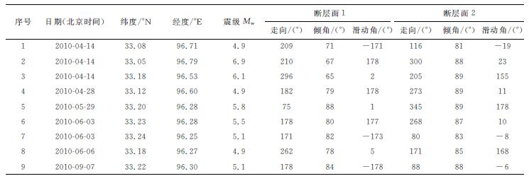
2010年玉树MS7.1地震及其最大余震的发震断层面均与地质上的主干走滑活动断层及其错动基本一致,然而,主震发生一个月后余震集中区域的震源机制解与断层走向差别较大.该余震集中区较大余震震源机制的两共轭断层面走向分别约为85°和175°,倾角约90°(表 1).2010年玉树MS7.1地震及其最大余震引起的库仑应力空间变化如图 8,其中图 8a和8b的接收断层走向为85°,图 8a为10 km深度上库仑应力变化的二维空间分布,图 8b为库仑应力变化在BB′断层深度剖面上的分布,余震集中分布在库仑应力显著增加的地区.图 8c和8d的接收断层走向为175°,图 8c为10 km深度上库仑应力变化的二维空间分布,图 8d为库仑应力变化在CC′断层深度剖面上的分布,半数以上余震分布在库仑应力显著减小的地区.综合上述同震库仑应力变化与余震空间分布情况,2010年玉树MS7.1地震1个月后的主要余震发生区地震活动可能受控于主震最大余震破裂北西端SW侧的近东西向断层(走向约为85°),而非玉树断裂的主干断裂.
|
|
表 1 2010年4月14日玉树7.1级地震主震及较大余震震源机制解(http://www.globalcmt.org/CMTsearch.html[2013-01-15]) Table 1 The focal mechanism solution of mainshock and larger aftershocks of the 14 April 2010 7.1 Yushu earthquake |

|
图 8 主震和最大余震引起的库仑应力变化.(a)10 km深度上水平空间分布(接收断层走向为85°);(b)沿余震断层走向剖面上分布(接收断层走向为85°,剖面上的余震为东经96.4°以西的余震在BB′断层面上的投影);(c)10 km深度上水平空间分布(接收断层走向为175°);(d)沿余震断层走向剖面上分布(接收断层走向为175°,剖面上的余震为东经96.4°以西的余震在CC′断层面上的投影) Fig. 8 Coulomb failure stress changes which caused by the main shock and the largest aftershock.(a) Horizontal spatial distribution in 10 km depth (the strike of receiving fault is 85°); (b) Distribution along the strike section of aftershocks (the strike of receiving fault is 85°, the aftershocks on the section is the projection of the aftershocks west of 96.4°E on the BB′ fault plane); (c) Horizontal spatial distribution in 10 km depth (the strike of receiving fault is 175°), (d) Distribution along the strike section of aftershocks (the strike of receiving fault is 175°, the aftershocks on the section is the projection of the aftershocks west of 96.4°E on the CC′ fault plane) |
甘孜-玉树断裂是青藏高原中东部地区羌塘地块和巴颜喀喇地块之间的边界断裂带,整体呈北西向,全长超过500 km,根据断层破裂和断层性质的局部特征,甘孜-玉树断裂可以分为5段,自东往西分别为甘孜段、玛尼干戈段、邓柯段、玉树段和当江段[27-28].甘孜玉树断裂带不同分段历史上相继发生了多次7级左右的强震,自东往西分别为甘孜段1854年M7.3地震、玛尼干戈段1866年M7.7地震、邓柯段1896年M7.0地震、玉树段2010年MS7.1地震和当江段1738年M6.5地震[28].2010年4月14日玉树7.1级地震之前,甘孜-玉树断裂带上的玉树段为强震破裂空段,综合主震和最大余震同震位错反演结果(图 5)以及余震重新定位结果[6],玉树空段在此次玉树7.1级地震序列中各段断层活动表现出不同的运动形式:主震同震破裂、最大余震破裂、余震集中活动(图 9a).

|
图 9 (a)甘孜-玉树断裂带强震破裂分布(蓝色为历史地震地表破裂分布,红色为2010年4月14日玉树MS7.1地震地表破裂,粉色为此次玉树地震的最大余震地表破裂);(b)甘孜玉树断裂带玉树段地质构造示意图(对应图 9a中红色框所示范围;图b中断裂是本研究综合卫星影像和相关地质考察研究结果给出的;虚线为本文推断断裂) Fig. 9 (a) Large earthquakes rupture distribution on the Garzê-Yushu fault zone (blue indicate the surface rupture distribution of history earthquakes, red indicate the surface rupture caused by the 14 April 2010 MS7.1 Yushu earthquake, pink indicate the surface rupture caused by the largest aftershock of the Yushu earthquake); (b) Sketch map of geological structure in the Yushu segment of the Garzê-Yushu fault zone (the area corresponds to the red box in Fig. 9a, the faults given by the satellite images and the related geological survey results, comprehensively, in this study; and the dashed lines are the inferred faults in this paper) |
甘孜-玉树断裂带玉树段分为东玉树断裂和西玉树断裂,以隆宝湖为分界,东玉树断裂向西延伸到隆宝湖北岸,西玉树断裂自隆宝湖南岸开始向西延伸[29](图 9b).2010年4月14日玉树MS7.1级地震发震断层为东玉树断裂,主震同震地表破裂分布在东玉树断裂的东段,虽然隆宝湖北岸东玉树断裂西段存在同震位错集中段(图 5a),但不论现场考察结果(图 5b)还是位错反演结果(图 5a)浅层同震位错均很小;而最大余震位于隆宝湖以西的西玉树断裂上,且有明显地表破裂分布(图 5).
余震空间与区域地质构造密切相关,由图 9b可知,余震空间分布存在3个明显集中区域,最东集中区为东玉树断裂东段断层间断处,即图 2中Fault 1和Fault 2中间位置;中间集中区域为隆宝湖两端,东玉树断裂和西玉树断裂共同作用区域;最西集中区为西玉树断裂往西延伸区域.东玉树断裂和西玉树断裂均为左旋走滑断裂,在隆宝湖地区表现为走滑断层系统内的典型拉张盆地[30].而西玉树断裂往西延伸区域次级断层较多,且极为复杂,空间上呈网状分布,按走向可以分为三组断层,北西向(走向130°~150°)和北东向(走向~50°)大致呈正交分布的两组断层,还有近东西向的断层,而综合震源机制解(表 1)和同震库仑应力变化(图 8),这组近东西向断层可能是最西余震集中区的控制断层,性质上应属于沿左旋走滑的玉树断裂玉树主震与最大余震破裂北西端SW侧的次级断裂,并被主震与最大余震同震位错“激活”(图 9b).
值得注意的现象是最大余震与最西余震集中区中间区域既没有显著的余震活动,也没有地震位错形式的断层运动,2010年玉树MS7.1地震序列活动期间,该段断层处于闭锁状态或者无震滑移,而最西余震集中区的控制断层可能不是西玉树断裂主干断裂,综合分析认为2010年玉树MS7.1地震序列活动期间玉树断裂带主干断层活动主要为隆宝湖附近及其以东断层.而根据相关地震史料和历史地震形变特征研究结果,1738年的破坏性地震震级可能达到7½级,而不是目录中的6½级,同震位错为玉树段和当江段的组合破裂形式[31].但1738年7½级地震的具体发震断层有待进一步讨论,如果包括东玉树断裂,则1738年7½级地震是东、西玉树断裂上多个凹凸体同时发生错动,而2010年MS7.1地震仅是东玉树断裂上的凹凸体发生错动,这种同一地区不同凹凸体以不同错动组合形式构成不同地震同震位错的情况还有,例如日本三陆地区存在两个较大的凹凸体,1968年十胜8.2级地震使得两个凹凸体均发生破裂,而1994年三陆7.7级地震仅发生在其中一个凹凸体上[32].如果1738年7½级地震发震断层不包括东玉树断裂,则2010年MS7.1地震为发生在典型强震破裂空段上的地震.
以往很多研究认为强震同震破裂与余震空间应具有一定的相关性,往往认为强震的余震多为在主震凹凸体周围的小凹凸体破裂[33].2010年玉树7.1级地震的最大余震和前期余震同样可以按照这种断层上凹凸体与地震间关系理解,但后期余震仍具有其特殊性,有可能是主震和强余震激活了相邻断层上的地震活动,这种现象在2008年汶川8.0级地震[34-35]主震发生于龙门山断裂带,而其北部某些强余震可能发生于北川断裂和青川断裂两个断裂上,而不是只发生在龙门山断裂带的中央断层上.这种余震空间分布显示出强震与区域断裂带构造系统之间关系的复杂性.
6 结论2010年玉树MS7.1地震主震与最大余震的同震位错反演结果与地表破裂考察结果表明主震同震断层运动主要发生在玉树断裂东段,最大余震同震断层运动发生在玉树断裂西段,均表现出左旋走滑性质,两者之间的隆宝湖地区表现为走滑断层系统内的典型拉张构造.余震最为集中区域为西玉树断裂往西延伸区域,距离主震同震破裂较远,次级断层较多且极为复杂,基于本文库仑应力变化空间分布结果,近东西向断层组可能是余震集中区的控制断层,性质上应属于沿左旋走滑的玉树断裂玉树主震与最大余震破裂北西端SW侧的次级断裂.由余震活动表现出的强震后效运动断层与强震发震断层并不一致,表明余震活动并不一定围绕或重叠于主震发震断层凹凸体,也可表现为被主震与最大余震同震位错“激活”的次级断裂.本文结果表明,玉树空段在此次玉树7.1级地震序列中各段断层活动表现主震同震破裂、最大余震破裂、余震集中活动等不同的运动形式,均与玉树断裂不同段表现出不同断层变形方式有着密切关系.
对于2010年玉树MS7.1地震同震位错及其余震与玉树断裂断层间关系,本文只是从同震位错和库仑应力变化、余震空间分布和断层形变特征等角度进行分析,笔者深感该地区相关问题的确定仍需地球物理、大地测量、古地震活动、断层运动等方面工作进行深入探讨.
致谢感谢中国科学技术大学查显杰副教授提供的此次玉树地震同震InSAR解译结果;感谢中国地震局地球物理研究所房立华博士提供的余震重定位结果;感谢德国波茨坦地学中心汪荣江博士提供的同震位错反演和同震库仑应力计算相关程序.
| [1] | Yin A, Harrison T M. Geologic evolution of the Himalayan-Tibetan orogeny. Annual Review of Earth and Planetary Sciences , 2000, 28(1): 211-280. DOI:10.1146/annurev.earth.28.1.211 |
| [2] | Tapponnier P, Xu Z Q, Francoise R, et al. Oblique stepwise rise and growth of the Tibet Plateau. Science , 2001, 294(5547): 1671-1677. DOI:10.126/science.105978 |
| [3] | Wang S F, Fan C, Wang G, et al. Late Cenozoic deformation along the northwestern continuation of the Xianshuihe fault system, Eastern Tibetan Plateau. GSA Bulletin , 2008, 120(3-4): 312-327. DOI:10.1130/B25833.1 |
| [4] | Molnar P, Dayem K E. Major intracontinental strike-slip faults and contrasts in lithospheric strength. Geosphere , 2010, 6(4): 444-467. DOI:10.1130/GES00519.1 |
| [5] | 张培震, 邓起东, 张国民, 等. 中国大陆的强震活动与活动地块. 中国科学(D辑) , 2003, 46(S2): 13–24. Zhang P Z, Deng Q D, Zhang G M, et al. Active tectonic blocks and strong earthquakes in the continent of China. Science in China, Ser. D: Earth Sciences (in Chinese) , 2003, 46(S2): 13-24. |
| [6] | Wang W L, Wu J P, Fang L H, et al. Relocation of the Yushu MS7.1 earthquake and its aftershocks in 2010 from HypoDD. Scinece China Earth Sciences , 2013, 56(2): 182-191. DOI:10.1007/s11430-012-4450-z |
| [7] | Li Z H, Elliott J R, Feng W P, et al. The 2010 Mw6.8 Yushu (Qinghai, China) earthquake: constraints provided by InSAR & body wave seismology. Journal Geophysical Research , 2011, 116. DOI:10.1029/2011JB008358 |
| [8] | Zhang Y, Xu L S, Chen Y T. Source process of the 2010 Yushu, Qinghai, earthquake. Scinece China Earth Sciences , 2010, 53(9): 1249-1251. DOI:10.1007/s11430-012-4045-5 |
| [9] | Guo J G, Zheng J J, Guan B B, et al. Associated with 2010 MS7.1 Yushu earthquake, China. Seismological Research Letters , 2012, 83. DOI:10.1785/gssrl83.1.109 |
| [10] | Zha X J, Dai Z Y, Ge L L, et al. Fault geometry and slip distribution of the 2010 Yushu earthquake inferred from InSAR measurement. Bulletin of the Seismological Society of America , 2011, 101(4): 1951-1958. DOI:10.1785/0120100192 |
| [11] | Fu G Y, Sun W K. Effects of spatial distribution of fault slip on calculating coseismic displacement: case studies of the Chi-Chi earthquake (Mw7.6) and the Kunlun earthquake (Mw7.8). Geophys. Res. Lett. , 2004, 31: L21601. |
| [12] | Wang R J, Xia Y, Grosser H, et al. The 2003 Bam (SE Iran) earthquake: precise source parameters from satellite radar interferometry. Geophys. J. Int. , 2004, 159(3): 917-922. DOI:10.1111/j.1365-2X.2004.02476 |
| [13] | Jiang M, Galvé A, Hirn A, et al. Crustal thickening and variations in architecture from the Qaidam basin to the Qang Tang (north-central Tibetan plateau), from wideangle reflection seismology. Tectonophysics , 2006, 412(3-4): 121-140. DOI:10.1016/j.tecto.2005.09.011 |
| [14] | Wei W B, Unsworth M, Jones A, et al. Detection of widespread fluids in the Tibetan crust by magnetotelluric studies. Science , 2001, 292(5517): 716-718. DOI:10.1126/science.1010580 |
| [15] | Zhu L P, Helmberger D V. Moho offset across the northern margin of the Tibetan plateau. Science , 1998, 281(5380): 1170-1172. DOI:10.1126/science.281.5380.1170 |
| [16] | Diao F Q, Xiong X, Wang R J. Mechanisms of transient postseismic deformation following the 2001 Mw7.8 Kunlun (China) earthquake. Pure and Applied Geophysics , 2011, 168(5): 767-779. DOI:10.1007/s00024-010-0154-5 |
| [17] | 张勇, 许力生, 陈运泰. 2010年青海玉树地震震源过程. 中国科学(地球科学) , 2010, 53(9): 1249–1251. Zhang Y, Xu L S, Chen Y T. Source process of the 2010 Yushu, Qinghai, earthquake. Sci. China Earth Sci. (in Chinese) , 2010, 53(9): 1249-1251. DOI:10.1007/s11430-010-4045-5 |
| [18] | Shan B, Xiong X, Zheng Y, et al. The coseismic Couloumb stress changes and expected seismicity rate caused by 14 April 2010 Ms=7.1 Yushu, China, earthquake. Tectonophysics , 2011, 510(3-4): 345-353. DOI:10.1016/j.tecto.2011.08.003 |
| [19] | 单斌, 李佳航, 韩立波, 等. 2010年MS7.1级玉树地震同震库仑应力变化以及对2011年MS5.2级囊谦地震的影响. 地球物理学报 , 2012, 55(9): 3028–3042. Shan B, Li J H, Han L B, et al. Coseismic Coulomb stress change caused by 2010 MS7.1 Yushu earthquake and its influence to 2011 Ms5.2 Nangqen earthquake and its influence to 2011 Ms5.2 Nangqen earthquake. Chinese J. Geophys. (in Chinese) , 2012, 55(9): 3028-3042. DOI:10.6038/j.issn.00015733.2012.09.02 |
| [20] | Jeager J C, Cook N G W. Fundamentals of Rock Mechanics. London: Chapman and Hall, 1979 . |
| [21] | Stein R S, Lisowski M. The 1979 Homestead Valley earthquake sequence, California, control of aftershock and postseismic deformation. J. Geophys. Re. , 1983, 88(B8): 6477-6490. DOI:10.1029/JB088iB08p06477 |
| [22] | King G C P, Stein R S, Lin J. Static stress changes and the triggering of earthquakes. Bull. Seismol. Soc. Am. , 1994, 84(3): 935-953. |
| [23] | Harris R A. Introduction to special section: stress triggers, stress shadows, and implication for seismic hazard. J. Geophys. Res. , 1998, 103(B10): 24347-24358. DOI:10.1029/98JB01576 |
| [24] | Wang R. A simple orthonormalization method for stable and efficient computation of Green's functions. Bull. Seismol. Soc. Am. , 1999, 89(3): 733-741. |
| [25] | Wang R, Lorenzo-Martín F, Roth F. Computation of deformation induced by earthquakes in a multi-layered elastic crust-FORTRAN programs EDGRN/EDCMP. Computers and Geosciences , 2003, 29(2): 195-207. DOI:10.1016/S0098-3004(02)00111-5 |
| [26] | Wang R, Lorenzo-Martín F, Roth F. PSGRN/PSCMP-a new code for calculating co-and post-seismic deformation, geoid and gravity changes based on the viscoelastic-gravitational dislocation theory. Computers and Geosciences , 2006, 32(4): 527-541. DOI:10.1016/j.cageo.2005.08.006 |
| [27] | 闻学泽, 徐锡伟, 郑荣章, 等. 甘孜-玉树断裂的平均滑动速率与近代大地震破裂. 中国科学(D辑) , 2003, 33(Suppl. 1): 199–208. Wen X Z, Xu X W, Zheng R Z, et al. The average slip rate and the surface rupture of recent earthquakes Ganzi-Yushu fault zone. Science in China (Series D) (in Chinese) , 2003, 33(Suppl. 1): 199-208. |
| [28] | 孙鑫喆, 徐锡伟, 陈立春, 等. 2010年玉树地震地表破裂带典型破裂样式及其构造意义. 地球物理学报 , 2012, 55(1): 155–170. Sun X Z, Xu X W, Chen L C, et al. Surface rupture features of the 2010 Yushu earthquake and its tectonic implication. Chinese J. Geophys. (in Chinese) , 2012, 55(1): 155-170. DOI:10.6038/j.issn.0001-5733.2012.01.015 |
| [29] | Tobita M, Nishimura T, Kobayashi T, et al. Estimation of coseismic deformation and a fault model of the 2010 Yushu earthquake using PALSAR interferometry data. Earth and Planetary Science Letters , 2011, 307(3-4): 430-438. DOI:10.1016/j.epsl.2011.05.017 |
| [30] | Woodcock N H, Fischer M. Strike-slip duplexes. Journal of Structural Geology , 1986, 8(7): 725-735. DOI:10.1016/0191-8141(86)90021-0 |
| [31] | 袁道阳, 雷中生, 何文贵, 等. 1738年青海玉树地震考证及其与2010年玉树7.1级地震关系探讨. 地球物理学进展 , 2011, 26(6): 1950–1958. Yuan D Y, Lei Z S, He W G, et al. Textual research of Yushu earthquake in 1738 A D in Qinghai Province and discussion their relationship with Yushu earthquake MS7.1 in 2010. Progress in Geophys. (in Chinese) , 2011, 26(6): 1950-1958. |
| [32] | Kato N. Numerical simulation of recurrence of asperity rupture in the Sanriku region, northeastern Japan. J. Geophys. Res. , 2008, 113. DOI:10.1029/2007JB005515 |
| [33] | 川崎一郎著.陈会忠, 黄伟, 黄建平等译.何谓慢地震.北京:地震出版社, 2013. Kawasaki I. What are Slow Earthquakes? NHK Publishing Inc, 2006 |
| [34] | Zheng Y, Ni S D, Xie Z J, et al. Strong aftershocks in the northern segment of the Wenchuan earthquake rupture zone and their seismotectonic implications. Earth Planet Space , 2010, 62(11): 881-886. DOI:10.5047/eps.2009.06.001 |
| [35] | 郑勇, 马宏生, 吕坚, 等. 汶川地震强余震(MS≥5.6)的震源机制解及其与发震构造的关系. 中国科学(地球科学) , 2009, 52(6): 739–753. Zheng Y, Ma H S, Lü J, et al. Source mechanism of strong aftershocks (MS≥5.6) of the 2008/05/12 Wenchuan earthquake and the implication for seismotectonics. Sci. China Ser. D-Earth Sci. (in Chinese) , 2009, 52(6): 739-753. DOI:10.1007/s11430-009-0074-3 |