2. 四川省地震局, 成都 610041
2. Earthquake Administration of Sichuan Province, Chengdu 610041, China
识别活动断裂带上的“地震空区”是判定潜在强震/大地震危险区的重要途径之一[1-4].然而,具有强震/大地震中-长期危险背景的“地震空区”不仅应是活动断裂带上长期未破裂的段落,也应能证明属于已长期闭锁、并具有高应力/应变积累或者具有较高发震概率的段落.因此,最近30多年来,国际上采用活动构造与强震破裂背景分析[1-7]、时间相依的断裂带分段发震概率评估[8-10]、构造大地测量学分析[11-12],以及现代地震活动性及其参数填图分析[13-14]等方法,进一步鉴别哪些地震空区更具有发生强震/大地震的中-长期危险性.最新完成和出版的《中国大陆大地震中-长期危险性研究》[15]也采用了基于地震地质与历史地震、现今地震活动性、以及大地形变/重力测量等多学科资料的综合研究方法.
川滇交界东段的NE向昭通、莲峰断裂带是一条地震研究程度相对较低的活动构造带.近十年来,该构造带及其附近发生的中-强地震明显增多,计有2003年云南鲁甸MS5.0和5.1级地震、2004年鲁甸MS5.6级地震、2006年云南盐津两次MS5.1级地震、以及2012年云南彝良MS5.7和5.6级地震.这使得昭通、莲峰断裂带是否具有发生强震/大地震的中-长期危险背景已成为一个亟待研究的问题.针对这一问题,本文基于现有的多学科观测资料,通过对区域活动构造与动力学背景、历史强震破裂背景、精定位小震分布及断裂带结构与构造特征、GPS速度场与断裂带形变特征、以及现今地震活动及其参数分布图像等的综合研究,初步评价该断裂带的强震/大地震危险背景,从中探索与试验基于地震构造分析、综合多学科信息的中-长期地震危险背景研究方法.
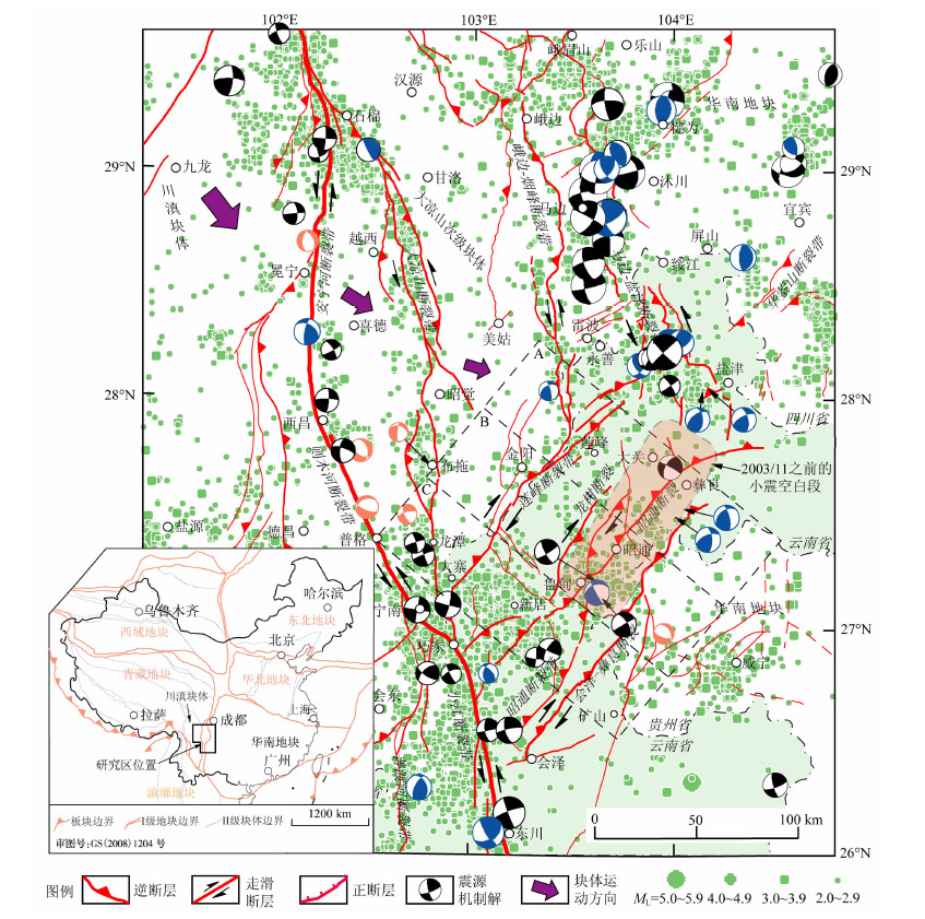
2 构造动力学背景与断裂带结构 2.1 区域活动构造与动力学背景昭通、莲峰断裂带由昭通、莲峰两条NE向断裂带组成,平行展布于川滇交界东段、四川大凉山南部至云南昭通之间的地区,局部进入贵州境内(图 1).该断裂带是在古生代时与四川盆地的华蓥山断裂带同期发育、中生代时进一步发展的以挤压逆冲为主的区域性大断裂,即属于古华蓥山断裂带的一部分[16].新生代以来随着青藏高原隆升、川滇块体朝南东挤出,NNW-近SN向则木河-小江断裂带和马边-盐津断裂带的发展分别截断了古华蓥山断裂带,使得昭通、莲峰断裂带成为全长约150km、相对独立的断裂带[16-17].
|
图 1 川滇交界东段及其邻近地区的活动断裂、现代地震与震源机制解 黑、蓝、桔色的沙滩球分别表示走滑、逆冲和正断为主的震源机制解[23-28];使用1980-2011年ML≥2.0地震资料绘制震中分布;虚线框A、B、C指示图 2和图 6的三个剖面地带;浅橙色影区示意2003年11月前的小震空白区.索引图示意研究区在中国大陆活动地块划分方案[18]中的位置. Fig. 1 Map of active faults, modern seismicity and focal mechanism solutions in the region of the eastern Sichuan-Yunnan border and its surroundings Beach balls in black, blue and orange show focal mechanism solutions[23-28]of dominantly strike-slip, reverse and normal faulting, respectively.The seismicity distribution contains all ML≥2.0 events from 1980 to 2011. The dashed rectangles A, B and C indicate zones for the 3 profiles in Fig. 2 and Fig. 6.The area in light-orange indicates a zone with very few small earthquakes before Nov 2003.The index map shows the position of the study region in the pattern of active tectonic blocks[18] of the Chinese continent. |
根据活动地块划分方案[18],NE向昭通、莲峰断裂带位于川滇块体与华南地块之间的边界带上,即属于I级活动地块边界带的一部分(图 1索引图).该断裂带北西侧是大凉山次级块体,其东侧边界的近SN向-NNW向马边-盐津断裂带表现出左旋走滑-挤压逆冲的晚第四纪活动特征,垂直滑动速率可达0.8 mm/a[19];该次级块体西侧边界的SN向-NNW向安宁河-则木河断裂带则以左旋走滑作用为主,速率4~7 mm/a[20-22].大凉山次级块体内部还发育有近SN向的大凉山、峨边-烟峰等活动断裂带,左旋走滑速率2~4 mm/a[22].这些说明大凉山次级块体的构造活动与变形作用也较强烈.因此,NE向昭通、莲峰断裂带也是活动与变形的大凉山次级块体与相对稳定的华南地块之间的分界带(图 1).
震源机制解[23-28]反映大凉山次级块体两侧边界及内部的SN向-NNW向安宁河-则木河、大凉山等断裂带的震源断层错动方式以左旋走滑为主,近SN向-NNW向马边-盐津断裂带以左旋走滑、或左旋走滑兼逆冲为特征,而NE向昭通、莲峰断裂带则表现出右旋走滑兼逆冲、或者以逆冲为主要错动方式.另外,沿峨边-烟峰、马边-盐津等断裂带分布的现代地震相对密集带,向南均转向昭通、莲峰断裂带(图 1).由此可推知,昭通、莲峰断裂带活动与变形的动力源应是直接来自大凉山次级块体的南东向运动,而间接来自川滇块体的南南东向运动[18, 29](图 1).
另外,我们开展的活动构造野外调查、配合高分辨率卫星影像分析等工作,已发现昭通、莲峰断裂带晚第四纪逆冲-右旋走滑错动的地质地貌证据(拟另文发表),反映出该断裂带地质上新活动的方式与现代地震震源机制解的断层错动方式(图 1)基本一致.
2.2 断裂带的剖面结构考虑到至今还没有穿越昭通、莲峰断裂带的地球物理探测剖面,我们采用绝对定位法(单纯形方法[30])和川滇地区的分层速度模型[31],对研究区1980-2011年的地震进行重新定位,并由重新定位的震源分布,结合地表活动断裂展布进行地震构造解释,最终绘制横跨昭通、莲峰断裂带的三个剖面(图 2),以便初步了解该断裂带的剖面结构与构造特征.图 2中除了包含过去30年的背景地震分布外,还有2012年9月7日云南彝良MS5.7和5.6级地震序列的余震分布(图 2剖面A的紫蓝色部分),同时含有2003-2004年云南鲁甸MS5.1、5.2和5.6地震(序列之后)的后续地震分布(图 2剖面B).

|
图 2 横跨昭通、莲峰断裂带的震源深度分布及构造解释剖面 剖面位置参见图 1.使用重新定位的1980-2011年ML≥2.0地震资料(绿色标识). 2012年9月彝良MS 5.7序列的余震资料(紫蓝色标识)由房立华博士提供. Fig. 2 Profiles across the Zhaotong and Lianfeng fault zones for hypocenter depth distribution and active-fault explanation See Fig. 1 for the profile positions.This research relocated the ML≥2.0 events (green dots) for the period from 1980 to 2011.Dr. FANG Li-Hua provided the relocated aftershock events (blue-purple dots) of the MS=5.7 Yiliang, Yunnan, sequence of Sept 2012. |
图 2的解释结果显示:昭通、莲峰断裂带在横剖面上呈现为两个平行、分隔展布的逆冲断裂带结构.其中,莲峰断裂带宽15~20km,由2~3个倾向北西的铲式断面组成,基底滑脱带深约11~15km.昭通断裂带由一个规模更大、结构更复杂的逆冲断裂带组成,其前缘主断裂---彝良-会泽断裂倾向北西,并在15~20km的深度与基底滑脱带相连;主滑脱带上方除发育有NW倾的次级断裂外,还有SE倾的反冲断裂;规模最大的反冲断裂是龙树断裂.我们经野外调查已证实了昭通断裂带的主断裂和两条反冲断裂的存在,而且具有晚第四纪活动性.
以上表明:昭通、莲峰断裂带是在早期形成的NE向逆冲-推覆构造带的基础上,新生代进一步发展而成的、两条相对独立的大型逆冲-右旋走滑活动断裂带,且具有晚第四纪活动性.因此,若从地震构造特征类比的观点,该两断裂带应具有发生强震/大地震的规模与能力.
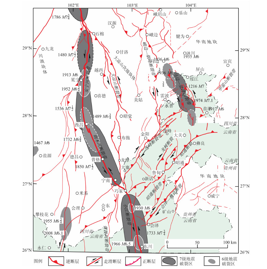
3 历史强震破裂背景地震破裂区是地震时沿发震断裂带同震错动面/破裂面在地面的垂直投影,指示了地震破裂的位置、尺度及其与发震构造的关系.本研究集成已有研究成果中的相关信息,编绘出研究区的强震/大地震破裂区分布图(图 3).图 3中沿安宁河、则木河、小江断裂带的地震破裂区,引自文献[7],其余断裂上的地震破裂区引自文献[15].在这些研究中,确定破裂区的方法是:1)对于1970年以来的现代地震,破裂区的确定主要参考余震分布、以及地表破裂带的展布;2)对于1970年之前的历史地震,破裂区的确定主要基于历史地震资料[32-35]中的烈度/破坏/有感分布信息,结合地震构造分析,采用Wen等(2008)建立的川-滇地区地震极震区烈度-破裂延伸烈度区间的经验准则[7]进行确定;该准则可简述为:极震区烈度Ih为Ⅺ、Ⅹ、Ⅸ和Ⅷ度的地震时,相应的破裂区沿发震断裂延伸于Ih至Ⅸ、Ⅷ、Ⅶ+和Ⅶ的烈度区间内[7].
|
图 3 川滇交界东段及其邻区活动断裂与强震/大地震破裂区展布图 Fig. 3 Map of active faults and rupture zones of strong and major earthquakes in the region of the eastern Sichuan-Yunnan border and its surroundings |
图 3反映最近700多年来研究区有记载和记录的MS≥6地震的破裂区分别沿大凉山次级块体东、西边界的马边-盐津断裂带的中-南段和安宁河-则木河-小江断裂带展布;而沿大凉山、峨边-烟峰、莲峰以及昭通等4条断裂带均无历史强震/大地震的破裂区.其中,大凉山、峨边-烟峰以及莲峰3条断裂带展布于大凉山腹地,那里的文字记载历史太短且不完整,在仪器记录之前即使发生过强震/大地震也很可能漏记[6].因此,本研究更加关心的是:沿昭通断裂带在相同的历史时期中没有记载/记录到MS≥6的地震事件,是已有很长时期没有强震/大地震发生的反映,还是由于漏记历史强震/大地震的结果?为此,进行如下分析.
云南昭通地区自古以来一直位于从四川盆地前往云南西南边陲的必经之路上.汉武帝建元六年(公元前135年)开设犍为郡,首府在今日四川的宜宾,治地则包括今日的滇东北、川南及贵西北交界的部分地区,其中的朱提(读作“殊时”)县管辖地即今日的昭通和鲁甸地区[36].
《晋书》(武帝纪)中记载了公元286年昭通附近的一次破坏性地震:“七年七月朱提之大泸山崩,犍为地震”[34];清道光的《云南通志》转记《宋书》(五行志)时写道“太康七年秋七月,朱提山崩,震坏郡舍”[35].这次地震的发生与昭通断裂带明显相关,原因是人文历史地理研究已考证了古朱提山主脉位于今云南昭通、鲁甸的西南部[37],那里也正好是昭通、莲峰断裂带经过之处(图 1,图 3).尽管现行地震目录[32]没有收录这次公元286年地震,但它能造成“朱提山崩,震坏郡舍”,应为中强震或强震.
由此看来,自公元286年地震以来昭通断裂带展布地区漏记MS≥7大地震的可能性较小.因此,沿昭通断裂带存在至少已有1726年未发生MS≥7大地震破裂的地震空区.
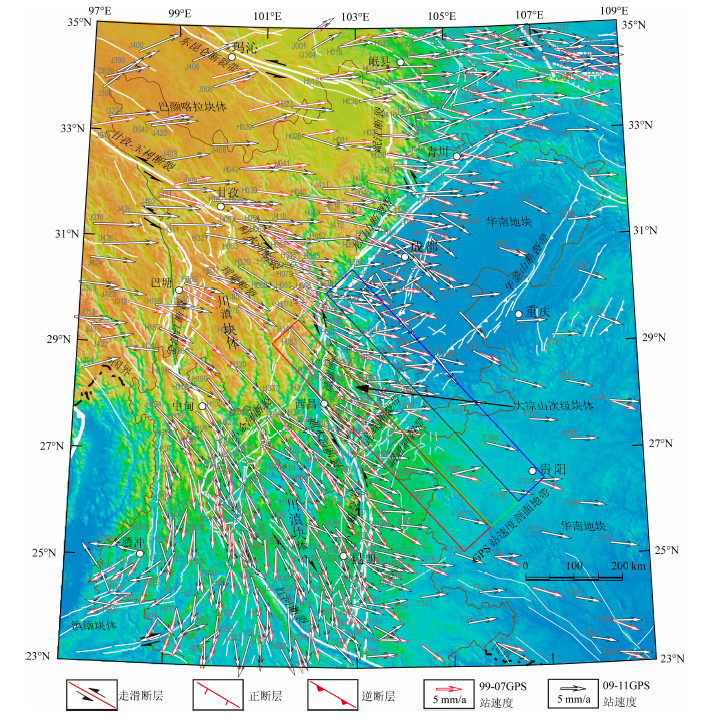
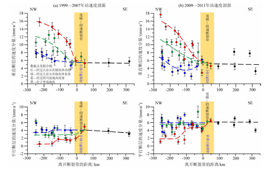
4 横跨断裂带的GPS变形特征基于1999-2007年、2009-2011年两期区域GPS速度场资料,分别绘制横跨昭通、莲峰断裂带南段和北段两个地带(图 4红、绿色虚线框)的GPS站速度剖面(图 5红、绿色数据点与拟合线).另外,为了进行比较分析,又绘制了横跨四川盆地华蓥山断裂带南段(宜宾-盐津段)地带(图 4蓝色虚线框)的GPS站速度剖面(图 5蓝色数据点与拟合线).
|
图 4 1999-2007年和2009-2011年的两期区域GPS速度场 三种颜色的矩形指示图 5中三种颜色GPS站速度剖面的地带. Fig. 4 Map of the regional GPS velocity fields for periods of 1999 to 2007 and 2009 to 2011 Rectangles in three colors indicate belts for the GPS velocity profiles in three colors in Fig. 5. |
|
图 5 横跨昭通、莲峰断裂带及华蓥山断裂带南段的GPS站速度剖面 (a)和(b)GPS速度场资料分别由王敏研究员和王琪教授提供.红、绿、蓝三色分别代表横跨昭通、莲峰断裂带南段、北段以及华蓥山断裂带南段的数据及拟合结果,剖面地带的位置参见图 4. Fig. 5 Profiles of GPS station-velocities across the Zhaotong and Lianfeng fault zones and the southern segment of the Huayingshan fault zone GPS station-velocity data in (a) and (b) are provided by Prof.WANG Min and Prof.WANG Qi, respectively.Red, green and blue colors distinguish data and fitting results for various profile belts across the southern and northern segments of the Zhaotong and Lianfeng fault zones, as well as the southern segment of the Huayingshan fault zone.See Fig.4 for positions of the profile belts. |
分析图 5a中GPS站速度分量随距离的变化显示:1999-2007年期间在横跨昭通、莲峰断裂带南段(巧家-鲁甸)和北段(鲁甸-盐津)的剖面地带上,垂直于和平行于断裂带走向的水平缩短变形和剪切变形主要发生在该断裂带的北西侧.其中,断裂带南段北西侧的水平缩短速率为4~6mm/a,水平剪切变形速率为2~3mm/a;断裂带北段北西侧的水平缩短速率2~3 mm/a,剪切变形速率0~1mm/a.然而,在同一时期,断裂带南、北两段内部的变形均很小,特别是昭通断裂带南、北两段的内部几乎无变形,亦即昭通断裂带内部的GPS站速度与华南地块中的几乎无差异.
图 5a中由红、绿色数据点与拟合线反映的变形图像与2008年四川汶川MS8.0级地震前、横跨龙门山断裂带中段的GPS变形图像[38-39]是非常相似的.这反映出在1999-2007年期间,昭通、莲峰断裂带南、北的两个段落已不同程度闭锁.其中,昭通断裂带的闭锁程度似乎更高,亦即可能具有更高的应变积累.
从图 5a的蓝色数据点与拟合线看出:1999-2007年期间横跨华蓥山断裂带南段(宜宾-盐津段)及其附近的地带没有出现水平缩短和剪切变形的相应特征,这与华蓥山断裂带在地质上不属于活动断裂(无晚第四纪以来的地表断错)的性质[17]相一致.而这种无变形的特征,也有力旁证了昭通、莲峰断裂带的确属于较高变形速率的活动断裂带,而且已有较高的应变积累(由图 5a中红、绿色数据点与拟合线).
图 5b反映2009-2011年期间,在横跨昭通、莲峰断裂带南段和北段的剖面地带上,水平缩短变形和剪切变形依然主要发生在该断裂带的北西侧,但与1999-2007年期间的(图 5a)相比,变形速率似乎有所减小.这种减小的一种可能原因是昭通、莲峰断裂带的闭锁作用加剧,使得断裂带的北西侧趋于应变“硬化”[40];但也有可能是由于2009-2011年测期的观测数据相对离散性较大,使得图 5b的拟合效果不佳所致,有待于后续的跟踪研究来证明.但无论如何,从GPS形变场看,昭通、莲峰断裂带南、北两个段落2009-2011年期间依然处于闭锁和应变积累状态.
5 断裂带的b值与小震图像古登堡-李克特的震级(M)-频度(N)关系lgN=a-bM中的b值是一个与应力积累水平呈反比的地震活动性参数,可通过b值填图识别沿活动断裂带的相对高应力/或者存在凹凸体的断裂段[13-15].易桂喜等曾在2008年汶川地震前通过b值填图发现沿龙门山断裂带存在两处异常低b值区,并判定为高应力积累的凹凸体部位[41];他们近年来的研究还发现在昭通断裂带中段、以及该断裂带与马边-盐津断裂带的交汇区附近也存在异常低b值区[42].
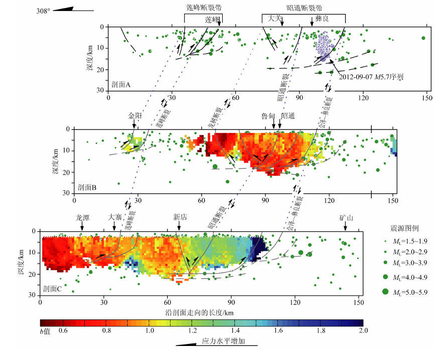
这里进一步利用由绝对定位法获得的本文研究区的重新定位地震目录,对横跨昭通、莲峰断裂带的三个剖面地带(图 1)进行b值计算,结果如图 6所示.
|
图 6 横跨昭通、莲峰断裂带3个剖面的b值图像 利用重新定位的1980-2011年地震资料计算,剖面位置参见图 1. Fig. 6 Section views of b-value distributions along 3 profiles across the Zhaotong and Lianfeng fault zones The relocated ML≥2.0 seismic data from 1980 to 2011 areused for the calculation.See Fig. 1 for the positions of the profiles. |
图 6剖面A由于小震数量太少而没能获得b值图像.
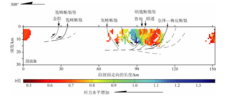
图 6的剖面B显示:在昭通断裂带中部的昭通、鲁甸附近存在异常低b值区,其分布在10~20km深度的主滑脱带及其与若干次级断裂的交汇部位附近;而且,昭通断裂带的重要分支---龙树断裂也在13km之上的深度存在异常低b值区.考虑到剖面B横跨了2003年11-12月、2004年4月鲁甸序列(MS=5.0、5.1和5.6及其余震)3次中-强震的震源区,我们还计算了该剖面在1980年1月-2003年6月期间的b值,结果反映在2003-2004年鲁甸序列之前的时段,剖面B在昭通至鲁甸之间、以及龙树断裂上盘的15km深度之上也存在低b值区(图 7).这说明鲁甸序列之前,那里已具有较高的应力积累背景.因此,图 6剖面B出现的异常低b值现象,更可能反映了昭通断裂带的昭通、鲁甸附近自2003、2004年鲁甸序列以来应力积累水平的进一步增加.
|
图 7 2003、2004年鲁甸序列之前横跨昭通、莲峰断裂带剖面B的b值图像 使用1980年1月-2003年6月时段的地震资料,剖面B的位置参见图 1. Fig. 7 Section views of b-value distribution before the 2003-2004 Ludian sequence along profile B across the Zhaotong and Lianfeng fault zones The relocated ML≥2.0 seismic data from Jan 1980 to Jun 2003 are used for the calculation.See Fig. 1 for the position of profile B. |
图 6的剖面C显示昭通断裂带的南段(新店及其以东)属于b值相对较高或应力水平相对不高的段落.然而,剖面C同时显示莲峰断裂带南段也存在异常低b值区,反映断裂带经过的巧家县大寨附近也已具有较高的应力积累.
另外,图 6剖面A反映在昭通断裂带北段的彝良、大关之下的主滑脱带附近存在小震空白区.2012年9月7日彝良MS5.7和5.6级地震序列即发生在该小震空白区的、昭通断裂带北段的主断裂上.实际上,在2003、2004年鲁甸序列发生之前,沿昭通断裂带的鲁甸-彝良段早已出现小震空白区(图 1的浅橙色影区),它指示出一个表现为长期小震相对平静的闭锁断裂段.而随后在该段南端附近出现的异常低b值现象(图 6剖面B),应进一步反映鲁甸-彝良断裂段已具有高应力积累.
6 讨论---危险断裂段及其潜在震级综上所述,昭通断裂带大体以鲁甸附近为界,南、北两段在断裂带几何结构方面存在差别(图 1).尽管GPS测量反映出昭通断裂带南、北两个断裂段均呈现闭锁与应变积累的形变特征(图 5的红、绿色数据点与拟合线),但北段(鲁甸-彝良段)还出现了小震空白区(图 1、图 2)、异常低b值区的背景(图 1、2、6、7).而且,这一断裂段最近十年已发生2003、2004年鲁甸和2012年彝良等中-强地震序列.因此,本研究将昭通断裂带北段(鲁甸-彝良段)初步判定为一个具有强震中-长期危险背景的断裂段.
根据鲁甸-彝良断裂段在2003、2004年鲁甸序列之前的小震空白区的长度L(约为100km,参见图 1的浅橙色影区),由经验公式MW=5.16+ 1.12lgL[43]以及MW=4.33+1.52lgL[44]分别估计出潜在地震的最大矩震级MW,结果均为MW=7.4.
7 结论(1)川滇交界东段的NE向昭通、莲峰断裂带属于川滇块体-华南地块边界带的一部分,也是活动与变形的大凉山次级块体与相对稳定的华南地块之间的边界带;其由2个平行、分隔的大型逆冲-右旋走滑活动断裂带组成;从活动构造性质及其规模上显示具有发生强震/大地震的能力.
(2)沿昭通断裂带存在地震空区,空区内无强震/大地震破裂的时间至少有1700多年.
(3)横跨昭通、莲峰断裂带的GPS形变图像与2008年汶川MS8.0级地震之前横跨龙门山断裂带中段的GPS形变图像很相似,反映两断裂带已不同程度闭锁;其中,昭通断裂带具有更高的闭锁与应变积累程度.
(4)昭通断裂带的鲁甸附近以及莲峰断裂带的南段,分别存在异常低b值或高应力区.其中,鲁甸附近的低b值区很可能与鲁甸-彝良之间的小震空白区一道,共同指示一个高应力的闭锁断裂段---鲁甸-彝良段,其潜在地震最大强度的估值为矩震级MW7.4.
因此,昭通断裂带存在中-长期强震/大地震危险背景,莲峰断裂带的中-长期地震危险性还需要进一步研究.另外,近十年来,昭通断裂带鲁甸-彝良段已在长期小震平静和闭锁的背景上发生了2003、2004年和2012年等多次中-强震事件,应进一步关注该断裂段以及整个昭通断裂带的中-长期强震危险性.
致谢本文使用了分别由王敏研究员和由王琪教授提供的GPS速度场数据、付虹研究员提供的云南地震台网的震相数据、以及房立华博士提供的2012年彝良地震序列的精定位数据.采纳了两位审稿专家提出的建设性修改意见.文中部分插图采用Stefan Wiemer的Zmap软件绘制.作者在此向他们表示衷心感谢.
| [1] | Sykes L R. Aftershock zones of great earthquakes, seismicity gaps, and earthquake prediction for Alaska and the Aleutians. J. Geophys. Res. , 1971, 76(32): 8021-8041. DOI:10.1029/JB076i032p08021 |
| [2] | Perez O J, Jacob K H. Tectonic model and seismic potential of the eastern Gulf of Alaska and Yakataga Seismic Gap. J. Geophys. Res. , 1980, 85(B12): 7132-7150. DOI:10.1029/JB085iB12p07132 |
| [3] | Davies J, Sykes L, House L, et al. Shumagin Seismic Gap, Alaska Peninsula: History of great earthquakes, tectonic setting, and evidence for high seismic potential. J. Geophys. Res. , 1981, 86(B5): 3821-3855. DOI:10.1029/JB086iB05p03821 |
| [4] | Gaudemer Y, Tapponnier P, Meyer B, et al. Partitioning of crustal slip between linked, active faults in the eastern Qilian Shan, and evidence for a major seismic gap, the 'Tianzhu gap', on the western Haiyuan Fault, Gansu (China). Geophys. J. Int. , 1995, 120(3): 599-645. DOI:10.1111/j.1365-246X.1995.tb01842.x |
| [5] | Wen X Z, Yi G X, Xu X W. Background and precursory seismicities along and surrounding the Kunlun fault before the Ms8.1, 2001, Kokoxili earthquake, China. J. Asian. Earth. Sci. , 2007, 30(1): 63-72. DOI:10.1016/j.jseaes.2006.07.008 |
| [6] | 闻学泽, 范军, 易桂喜, 等. 川西安宁河断裂上的地震空区. 中国科学(D辑)--地球科学 , 2008, 51(10): 1375–1387. Wen X Z, Fan J, Yi G X, et al. A seismic gap on the Anninghe fault in western Sichuan, China. Science in China: Earth Sci. (in Chinese) , 2008, 51(10): 1375-1387. DOI:10.1007/s11430-008-0114-4 |
| [7] | Wen X Z, Ma S L, Xu X W, et al. Historical pattern and behavior of earthquake ruptures along the eastern boundary of the Sichuan-Yunnan faulted-block, southwestern China. Phys. Earth. Planet. Inter. , 2008, 168(1-2): 16-36. DOI:10.1016/j.pepi.2008.04.013 |
| [8] | Nishenko S P. Circum-Pacific seismic potential: 1989-1999. Pure Appl. Geophys. , 1991, 135(2): 169-259. DOI:10.1007/BF00880240 |
| [9] | 闻学泽. 时间相依的活动断裂分段地震危险性评估及其问题. 科学通报 , 1998, 43(14): 1937–1950. Wen X Z. Assessment of time-dependent seismic hazards on segments of active fault, and its problems. Chinese Sci. Bull. (in Chinese) , 1998, 43(14): 1937-1950. |
| [10] | Working Group on California Earthquake Probabilities. Earthquake Probabilities in the San Francisco Bay Region: 2002-2031, U. S. Geological Survey Open-File Report, 2003. 03-214. |
| [11] | Bilham R, Gaur V K, Molnar P. Himalayan seismic risk. Science , 2001, 293(5534): 1442-1444. DOI:10.1126/science.1062584 |
| [12] | Fialko Y. Interseismic strain accumulation and the earthquake potential on the southern San Andreas fault system. Nature , 2006, 441(7096): 968-971. DOI:10.1038/nature04797 |
| [13] | Wiemer S, Wyss M. Mapping the frequency-magnitude distribution in asperities: An improved technique to calculate recurrence times?. J.Geophys. Res. , 1997, 102(B7): 15115-15128. DOI:10.1029/97JB00726 |
| [14] | Wyss M. Fractal dimension and b-value on creeping and locked patches of the San Andreas fault near Parkfield, California. Bull. Seism. Soc. Am. , 2004, 94(2): 410-421. DOI:10.1785/0120030054 |
| [15] | M7专项工作组. 中国大陆大地震中-长期危险性研究. 北京: 地震出版社, 2012 : 1 -336. Working Group of M7. Study on the Mid-to Long-term Potential of Large Earthquakes on the Chinese Continent (in Chinese). Beijing: Seismological Press, 2012 : 1 -336. |
| [16] | 四川省地质矿产局. 四川省区域地质志. 北京: 地质出版社, 1991 : 154 -281. Bureau of Geology and Mineral Resources of Sichuan Province. Regional Geology of Sichuan Province (in Chinese). Beijing: Geological Publishing House, 1991 : 154 -281. |
| [17] | 周荣军, 唐荣昌, 钱洪, 等. 地震构造类比法的应用--以川东地区华蓥山断裂带为例. 地震研究 , 1997, 20(3): 316–322. Zhou R J, Tang R C, Qian H, et al. An application of seismotectonic analogy to the Huayingshan fault zone in east Sichuan. Journal of Seismological Research (in Chinese) , 1997, 20(3): 316-322. |
| [18] | 张培震, 邓起东, 张国民, 等. 中国大陆的强震活动与活动地块. 中国科学D辑(地球科学) , 2003, 46(Suppl.1): 13–24. Zhang P Z, Deng Q D, Zhang G M, et al. Active tectonic blocks and strong earthquakes in the continent of China. Sci. China Ser. D (in Chinese) , 2003, 46(Suppl.1): 13-24. |
| [19] | 张世民, 聂高众, 刘旭东, 等. 荥经-马边-盐津逆冲构造带断裂运动组合及地震分段特征. 地震地质 , 2005, 27(2): 221–233. Zhang S M, Nie G Z, Liu X D, et al. Kinematical and structural patterns of Yingjing-Mabian-Yanjin thrust fault zone, Southeast of Tibetan plateau, and its segmentation from earthquakes. Seismology and Geology (in Chinese) , 2005, 27(2): 221-233. |
| [20] | 闻学泽. 四川西部鲜水河-安宁河-则木河断裂带的地震破裂分段特征. 地震地质 , 2000, 22(3): 239–249. Wen X Z. Character of rupture segmentation of the Xianshuihe-Anninghe-Zemuhe fault zone, western Sichuan. Seismology and Geology (in Chinese) , 2000, 22(3): 239-249. |
| [21] | 何宏林, 池田安隆. 安宁河断裂带晚第四纪运动特征及模式的讨论. 地震学报 , 2007, 20(5): 571–583. He H L, Yasutakyr I. Faulting on the Anninghe fault zone, Southwest China in Late Quaternary and its movement model. Acta Seismologica Sinica (in Chinese) , 2007, 20(5): 571-583. DOI:10.1007/s11589-007-0571-4 |
| [22] | 何宏林, 池田安隆, 何玉林, 等. 新生的大凉山断裂带--鲜水河-小江断裂系中段的裁弯取直. 中国科学D辑(地球科学) , 2008, 51(9): 1248–1258. He H L, Yasutaka I, He Y L, et al. Newly-generated Daliangshan Fault zone-Shortcutting on the central segment of Xianshuihe-Xiaojiang Fault system. Sci. China Ser. D (in Chinese) , 2008, 51(9): 1248-1258. DOI:10.1007/s11430-008-0094-4 |
| [23] | 国家地震局震源机制研究小组. 中国地震震源机制研究(第一集). 国家地震局 , 1973: 1–206. Working Group on Focal Mechanisms of State Seismological Bureau. Study on Focal Mechanism Resolutions of Earthquakes in China (Report Ⅰ). State Seismological Bureau of China (in Chinese) , 1973: 1-206. |
| [24] | 国家地震局震源机制研究小组. 中国地震震源机制研究(第二集). 国家地震局 , 1973: 1–77. Working Group on Focal Mechanisms of State Seismological Bureau. Study on Focal Mechanism Resolutions of Earthquakes in China (Report Ⅱ). State Seismological Bureau of China (in Chinese) , 1973: 1-77. |
| [25] | 阚荣举, 张四昌, 晏凤桐, 等. 我国西南地区现代构造应力场与现代构造活动特征的探讨. 地球物理学报 , 1977, 20(2): 96–109. Kan R J, Zhang S C, Yan F T, et al. Discussion on characteristics of recent tectonic stress field and recent tectonic movement in southwestern China. Chinese J. Geophys. (in Chinese) , 1977, 20(2): 96-109. |
| [26] | 阚荣举, 王绍晋, 黄崐, 等. 中国西南地区现代构造应力场与板内断块相对运动. 地震地质 , 1983, 5(2): 79–90. Kan R J, Wang S J, Huang K, et al. Modern stress field and relative motion of intraplate block in southwest China. Seismology and Geology (in Chinese) , 1983, 5(2): 79-90. |
| [27] | 成尔林. 四川及其邻区现代构造应力场和现代构造运动特征. 地震学报 , 1981, 3(3): 231–241. Cheng E L. Current tectonic stress and tectonic movement characteristics of Sichuan and its adjacent areas. Acta Seimologica Sinica (in Chinese) , 1981, 3(3): 231-241. |
| [28] | Global CMT Catalog Search. http://www.globalcmt.org/CMTsearch.Html. |
| [29] | 张培震. 青藏高原东缘川西地区的现今构造变形、应变分配与深部动力过程. 中国科学D辑(地球科学) , 2008, 38(9): 1041–1056. Zhang P Z. The tectonic deformation, strain distribution and deep dynamic processes in the eastern margin of the Qinghai-Tibetan plateau. Sci. China Ser. D (in Chinese) , 2008, 38(9): 1041-1056. |
| [30] | Prugger A F, Gendzwill D J. Microearthquake location: a nonlinear approach that makes use of a simplex stepping procedure. Bull. Seism. Soc. Am. , 1988, 78(2): 799-815. |
| [31] | 赵珠, 张润生. 四川地区地壳上地幔速度结构的初步研究. 地震学报 , 1987, 9(2): 154–166. Zhao Z, Zhang R S. Primary study of crustal and upper mantle velocity structure of Sichuan Province. Acta Seismologica Sinica (in Chinese) , 1987, 9(2): 154-166. |
| [32] | 国家地震局震害防御司编. 中国历史强震目录. 北京: 地震出版社, 1995 : 1 -514. Department of Earthquake Disaster Prevention, State Seismological Bureau. The Catalogue of Chinese Historical Earthquakes (in Chinese). Beijing: Seismological Press, 1995 : 1 -514. |
| [33] | 中国地震局震害防御司编. 中国近代地震目录. 北京: 中国科学技术出版社, 1999 : 1 -637. Department of Earthquake Disaster prevention, China Earthquake Administration. The Catalogue of Chinese Modern Earthquakes (in Chinese). Beijing: Science and Technology of China Press, 1999 : 1 -637. |
| [34] | 四川地震资料汇编编辑组编. 四川地震资料汇编(第一卷). 成都: 四川人民出版社, 1980 : 1 -576. Editor Group of the Data Compilation of Earthquakes in Sichuan. The Data Compilation of Earthquakes in Sichuan (Book 1) (in Chinese). Chengdu: People's Publishing House of Sichuan, 1980 : 1 -576. |
| [35] | 云南省地震局. 云南省地震资料汇编. 北京: 地震出版社, 1988 : 1 -569. Seismological Bureau of Yunnan Province. Data Compilation of Historical Earthquakes of Yunnan Province (in Chinese). Beijing: Seismological Press, 1988 : 1 -569. |
| [36] | 吴喜, 李祥. 古代昭通地区政区设置及变迁略考. 昭通师范高等专科学校学报 , 2011, 33(1): 6–10. Wu X, Li X. On the establishment and the transition of the administrative district in Ancient Zhaotong. Journal of Zhaotong Teacher's College (in Chinese) , 2011, 33(1): 6-10. |
| [37] | 方国瑜. 中国西南历史地理考释. 北京: 中华书局, 1987 : 1 -1310. Fang G Y. Exploration on the History and Geography of Southwest China (in Chinese). Beijing: Zhonghua Book Company, 1987 : 1 -1310. |
| [38] | 张培震, 闻学泽, 徐锡伟, 等. 2008年汶川8.0级特大地震孕育和发生的多单元组合模式. 科学通报 , 2009, 54(7): 944–953. Zhang P Z, Wen X Z, Xu X W, et al. Tectonic model of the great Wenchuan earthquake of May 12, 2008, Sichuan, China. Chinese Sci. Bull. (in Chinese) , 2009, 54(7): 944-953. |
| [39] | 杜方, 闻学泽, 张培震, 等. 2008年汶川8.0级地震前横跨龙门山断裂带的震间形变. 地球物理学报 , 2009, 52(11): 2729–2738. Du F, Wen X Z, Zhang P Z, et al. Interseismic deformation across the Longmenshan fault zone before the 2008 M8.0 Wenchuan earthquake. Chinese J. Geophys. (in Chinese) , 2009, 52(11): 2729-2738. |
| [40] | Savage J C, Prescott W H. Asthenosphere readjustment and the earthquake cycle. J. Geophys. Res. , 1978, 83(B7): 3369-3376. DOI:10.1029/JB083iB07p03369 |
| [41] | 易桂喜, 闻学泽, 王思维, 等. 由地震活动参数分析龙门山-岷山断裂带的现今活动习性与强震危险性. 中国地震 , 2006, 22(2): 117–125. Yi G X, Wen X Z, Wang S W, et al. Study on fault sliding behaviors and strong-earthquake risk of the Longmenshan-Minshan fault zones from current seismicity parameters. Earthquake Research in China (in Chinese) , 2006, 22(2): 117-125. |
| [42] | 易桂喜, 闻学泽, 张致伟, 等. 川南马边地区强震危险性分析. 地震地质 , 2010, 32(2): 282–293. Yi G X, Wen X Z, Zhang Z W, et al. Study on potential strong earthquake risk in Mabian area, southern Sichuan. Seismology and Geology (in Chinese) , 2010, 32(2): 282-293. |
| [43] | Wells D L, Coppersmith K L. New empirical relationships among magnitude, rupture width, rupture area, and surface displacement. Bull. Seism. Soc. Am. , 1994, 84(4): 974-1002. |
| [44] | Leonard M. Earthquake fault scaling: self-consistent relating of rupture length, width, average displacement, and moment release. Bull. Seism. Soc. Am. , 2010, 100(5A): 1971-1988. DOI:10.1785/0120090189 |
 2013, Vol. 56


