 2012, Vol. 55


地震波因地壳介质的非均匀性引起的散射和介质非弹性吸收而引起的地震波能量的衰减可以用介质的品质因子(即地震波Q值)来表述.地震波Q值是除地震波速度外,地球深部结构及地球动力学所研究的另一个非常重要的地球物理学参数.大量研究结果表明,地壳上地幔地震波速度的横向变化通常只有百分之几,而地壳上地幔Q值的横向变化的量级却在数十倍以上[1].因此借助于对地壳Q值的研究,可以更准确的认识地壳的结构特征.当地震波穿过构造活动区时,能量将发生强烈衰减而具有低Q值,而在一些构造稳定的地区则因衰减较少而具有高Q值[2-7].从而进一步认识火山区的岩浆分布、构造活动区的断层分布、壳内低速层等.
东北地区在构造上位于中朝板块和西伯利亚板块之间,属于天山—兴蒙地槽褶皱系的东支.中、新生代以来,受太平洋板块向西俯冲的影响,中国东北部形成了以扩张为主、局部压张的大地构造格局,形成了一系列北东向、北东东向为主的造山带-盆地构造单元,并伴有强烈的火山作用与地震活动发生[8-12].为探讨太平洋板块俯冲及其对中国东北地区的影响,科学家在该区开展了大量的人工地震和天然地震研究,很好地刻画了研究区的壳幔速度结构[13-22].在该区开展地震波Q值研究,将为地学家更准确的认识中国东北及周边地区的壳幔结构提供重要的约束.
目前,多数学者直接利用数字地震波形资料,如Lg尾波或长周期面波[23-27]等开展Q值的研究,但其受到台站密度和资料数量的限制,缺少足以覆盖研究区域的大量数据.为获得更好的射线覆盖和分辨率,可利用测定震级NL的振幅数据开展对Q值的研究[2-7].汪素云等[4-5]利用中国地震年报(1984—2004年)测定NL 所用的54000余条区域地震最大振幅数据资料,反演了中国大陆地壳介质品质因子Q0 结构.虽然射线覆盖面很大,但是对于东北区域来说,射线覆盖还不够密集,结果的分辨率不足3°×3°.本文利用中国地震年报和地方台网测定的中国东北及周边区域地震的最大振幅资料,反演东北及周边地区地壳介质品质因子Q0 结构,进而为东北及周边地区壳幔结构及构造活动的分布和强度的研究提供依据.
2 资 料本文研究的范围为(30°N—60°N,110°E—140°E),主要包括了东北地区和华北北部地区.所用观测数据来源于《中国地震年报》(1984年1月—2008年6月)、黑龙江、吉林、辽宁和内蒙古四省地震台网观测报告(2001年1月—2008年12月).在近距离内(震中距<200km),测定NL 所用的振幅多为直达S波的最大振幅;而震中距>200km 时,为Lg波的最大振幅.在本文中简化统称为横波的最大振幅.为了获得高精度和有广泛均匀覆盖面的数据,对数据进行筛选需要满足下列条件:(1)震中距在1°~7°范围内,震源深度小于45km;(2)每个地震事件至少有3个地震台站记录到;(3)每个地震台站至少记录到3个地震事件.删除不符合上述条件的数据记录,最后共选出在146个台站上记录到的6371个近震的46652条射线数据.最终采用的横波振幅数据的台站和地震位置以及射线分布图见图 1.

|
图 1 射线路径及台站、地震位置 Fig. 1 Ray paths,earthquake and seismic station locations |
我们所采用的反演方法在汪素云等[5]的文章中有详细讲解,本文只做简单的介绍:
地震波在传播路径上的衰减,直接表现为地震波振幅的变化.其主要的影响因素有:(1)台站及仪器响应,(2)震源强度,(3)几何扩散,(4)介质衰减.因此地震波振幅可用以下形式表述:
|
(1) |
(1)式中,A是记录到的地震波的振幅,f是频率,r为震中距,其中,I(f)是台站响应;


|
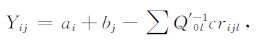
(2) |
式中,ai是台站校正项,负值表示台站下方衰减较大,而正值则表示台站下方增益较大.其绝对值越小表示仪器标定准确,场地地质环境较好,台站的台基相对较好.bj是地震震源校正项,负值表示实际震级比目录给出的要小,而正值则表示实际震级要比目录给出的大.Q′0l为网络内频率为1Hz时的品质因子Q0 的变化.rijl为第j个地震到第i个台站的射线经过第l个网络的长度.反演中速度v取为3.6km/s.通过预条件LSQR 共轭梯度最小二乘的迭代算法来求解.迭代次数取为60 次,网格大小取为20′×20′;阻尼常数取为1000.经反演迭代计算,最终得到了Q0 值的区域变化图像、台站增益校正项和震源尺度扰动项.该方法已在华北和川滇等地区[5-7]得到了成功的应用.
4 反演结果及分析图 2是反演得到的地壳横波衰减的介质品质因子Q0空间分布图.图中用不同颜色表示Q0 值的变化分布,红色对应比平均Q0 值低的区域(高衰减区),蓝色对应比平均Q0 值高的区域(低衰减区).从图中可见,相对于Q0 的平均值323,Q0 横向变化量为-200至200.从图 2显示渤海地区Q0 值最小,衰减最高;松辽盆地、海拉尔平原等稳定地块区Q0 值相对较小,衰减较高;整个东北地区呈高低衰减带相间分布.

|
图 2 Q0横向变化图像(Q0变化是相对于均值323) Fig. 2 Q0variation within the crust beneath China.Q0 perturbations are relative to 323 |
图 3a给出了台站校正ai分布图,ai介于-0.25至+0.35个震级单位,有60%的台站|ai|≤0.1个震级单位;只有10% 的台站|ai|> 0.2 个震级单位.台站校正系数比较小,故可以看出东北及邻区台站的台基相对较好.图 3b 给出了震源校正bj分布图,bj介于-0.51至+0.52个震级单位,有64%震源校正项|bj|≤0.1 个震级单位;只有9% 的台站|bj|>0.2个震级单位.许多地方如渤海附近,是由于高衰减带造成经过的射线振幅衰减较大,震源尺度估计偏低.震级测定会受到地壳介质衰减横向变化的影响.

|
图 3 台站相对增益分布(a)及震源校正项分布(b) Fig. 3 (a)Station term perturbations and event term perturbations(b)event term perturbations |
图 4给出了采用测试板方法测试地壳介质品质因子Q0 值空间分布结果的分辨率,即对相同的射线分布及阻尼常数,用不同尺度的测试版试验模型,施加幅值为±200的正弦函数Q0 扰动模型计算理论振幅残差,反演出给定的Q0 扰动模型的恢复结果.在绝大部分地区都达到2°×2°的分辨率.本文还采用计算100次的bootstrap 方法反演,每次迭代60次,得出Q0 横向变化,其中97%的地区误差不超过20,从而进一步验证本研究得到的Q0 值的可靠性及稳定性.

|
图 4 分辨率测试(a)3°×3°,(b)2°×2° Fig. 4 Checkerboard resolution tests for(a)3°×3°squares and (b)2°×2°squares |
利用中国地震年报、黑龙江、吉林、辽宁和内蒙古四省地震台网观测报告的横波振幅与周期资料,进行了振幅的层析成像研究.在前人的研究[5, 7]基础上,本文工作补充了中国东北及邻区地方台网和2005—2008年《地震年报》中的2万多条射线数据,从而大大提高了反演结果的分辨率.检测板测试表明,研究区基本上达到了2°×2°的分辨率,仅在北纬50°以北的最边缘部分由于区域台站数据量少,射线覆盖较稀,分辨率为3°×3°.反演结果显示,东北及周边地区地壳介质品质因子Q0 平均值为323,其Q0 值分布及其所揭示的衰减变化特征与研究区的地表构造具有明显的相关性,如华北平原、松辽盆地和海拉尔平原等沉积层较厚的区域通常呈现为低Q0 值;而燕山、太行、兴蒙褶皱带等沉积层薄或基岩出露的区域则呈现为相对高的Q0 值.本文结果与Zhao等[24]利用Lg尾波所得到的研究区的衰减特征非常相似:Q0 值横向变化相似,但大小并不一致.这与我们结果中Q0 值的大小与反演中几何扩散项中的系数K和介质吸收项中η,v参数的选取有关,由于几何扩散项和介质吸收项的相关性,当几何扩散系数K增高时,几何扩散项增大,介质吸收项会减少,因而Q0 值增大;而当固定K值时,随着η 的减少,Q0 值也会增加.下面着重研究的是Q0 值的横向变化图像.

|
图 5 东北及邻区沉积层厚度分布(a)和大地热流分布(b) Fig. 5 (a)Distribution of sedimentary thickness in Northeast China and adjacent regions(b)Distribution of heat flow in Northeast China and adjacent regions |
Q0 值的横向变化表现的是地壳中地震波能量的衰减分布,其大小与沉积层厚度、构造活动的强弱作用及地壳介质属性关系密切.图 5a为采用CRUST2.0[28]获得的沉积层厚度的数据绘成东北及邻区沉积层厚度分布图,对比地壳衰减结果与沉积层厚度发现,东北及其邻区反演得到的介质品质因子Q0 值分布与沉积层厚度之间的密切关系:沉积层较厚,Q0 值较低,衰减较强,如在渤海湾地区、松辽盆地等;沉积层较薄,Q0 值较高,衰减较弱.另外松辽盆地等沉积较厚区域的低Q0 值可能与沉积层内孔隙为含水流体充填有一定关系[7].东北及其邻区反演得到的介质品质因子Q0 值分布与地壳的温度也有一定的相关性.图 5b 为根据胡圣标等[29]发表的中国大陆地区大地热流数据汇编(第三版)给出的研究区大地热流分布图.对比地壳衰减结果与大地热流分布发现,在具有可比性的稳定地块区,呈现出强衰减对应高的大地热流值的特性.如在松辽盆地、海拉尔平原等稳定地块区,Q0 值较低,衰减较强,对应的大地热流也较高;而其周边的褶皱带,Q0 值较高,衰减较弱,对应的大地热流则偏低.
本文所揭示的研究区的Q0 值横向变化与已有的Pn,Sn 成像结果[30-34]也具有很好的相关性,在Pn和Sn速度高的地区地壳Q0 值高;在低Pn速度或者Sn传播无效区地壳Q0 值低.前人[35-37]曾经将藏北地区的低Pn速度、强烈的Sn、Lg高频衰减以及高泊松比的地球物理特征解释为壳内部分熔融的证据.研究区内的五大连池火山和天池火山是我国大陆境内有过历史喷发记载的近代活动火山.80年代以来在上述活动火山地区开展的大量地球物理调查表明,五大连池火山和天池火山下方存在壳内低速区或者壳内岩浆房[38-42].但是本文研究显示,上述火山地区并没有显著的衰减.这可能是由于上述火山地区的岩浆房太小,或者本文的Q0 值成像结果分辨率不够而无法分辨的缘故.
我们发现的另一个有趣的现象是,尽管都属于沉积层较厚的盆地地区,但是华北平原较松辽平原的Q0 值明显要低.本文显示的华北平原这种强烈的衰减特征与前人所揭示的低的壳幔P、S波速度、薄的岩石圈盖层[43-44]都暗示华北克拉通岩石圈结构遭受了强烈的改造作用.如果东北地区低的Q0 值也与太平洋俯冲导致的中国东部岩石圈破坏有关,那么这很可能暗示华北岩石圈破坏程度要大于东北地区,或者东北地区岩石圈破坏的时间要早于华北地区[10, 45].
致谢感谢刘瑞丰研究员提供《中国地震年报》资料,感谢国家地震科学数据共享中心和中国地震台网中心提供的地震震相数据.
| [1] | Romanowicz B. The upper mantle degree two: constraints and inferences from global mantle wave attenuation measurements. J. Geophys. Res , 1990, 95(B7): 11051-11071. DOI:10.1029/JB095iB07p11051 |
| [2] | Hearn T, Beghoul N, Barazangi M, et al. Tomography of the western United States from regional arrival times. J. Geophys. Res , 1991, 96(B10): 16369-16381. DOI:10.1029/91JB01509 |
| [3] | Hearn T M, Wang S Y, Pei S P, et al. Seismic amplitude tomography for crustal attenuation beneath China. J. Int , 2008, 174(1): 223-234. |
| [4] | 汪素云, 裴顺平, 许忠淮, 等. 利用ML振幅研究地壳横波Q0值I: 不同构造区的衰减特征. 地球物理学报 , 2007, 50(6): 1740–1747. Wang S Y, Pei S P, Xu Z H, et al. Crustal S-wave Q estimated from ML amplitude I: attenuation in different tectonic regions of China. Chinese J. Geophys (in Chinese) , 2007, 50(6): 1740-1747. |
| [5] | 汪素云, 裴顺平, ThomasM Hearn, 等. 利用ML振幅研究地壳横波Q0值II: Q横向变化特征. 地球物理学报 , 2008, 51(1): 133–139. Wang S Y, Pei S P, Thomas M Hearn, et al. Crustal S-wave Q estimated from ML amplitude II: Q lateral variation in China. Chinese J. Geophys (in Chinese) , 2008, 51(1): 133-139. |
| [6] | 马宏生, 汪素云, 裴顺平, 等. 川滇及周边地区地壳横波衰减的成像研究. 地球物理学报 , 2007, 50(2): 465–471. Ma H S, Wang S Y, Pei S P, et al. Q0 tomography of S wave attenuation in Sichuan-Yunnan and adjacent regions. Chinese J. Geophys| (in Chinese) , 2007, 50(2): 465-471. |
| [7] | Pei S P, Zhao J M, Rowe C A, et al. MLamplitude tomography in North China. Bulletin of the Seismological Society of America , 2006, 96(4): 1560-1566. |
| [8] | 赵大鹏, 雷建设, 唐荣余. 中国东北长白山火山的起源: 地震层析成像证据. 科学通报 , 2004, 49(14): 1439–1447. Zhao D P, Lei J S, Tang R Y. The origin of Changbaishan volcano in Northeast China: the tomography evidence. Chinese Science Bulletin (in Chinese) , 2004, 49(14): 1439-1447. |
| [9] | 张凤鸣, 张亚江, 许晓艳, 等. 日本海西部-中国东北深震区俯冲运动对东北地区浅源地震的动力的作用. 东北地震研究 , 2007, 23(1): 33–39. Zhang F M, Zhang Y J, Xu X Y, et al. Dynamic action on the subduction movement of the west part of Japan sea-deep focus earthquake region in northeast area of China to the shallow source earthquake in northeast area. Seismological Research of Northeast China (in Chinese) , 2007, 23(1): 33-39. |
| [10] | 吴福元, 葛文春, 孙德有, 等. 中国东部岩石圈减薄研究中的几个问题. 地学前缘 , 2003, 10(3): 51–60. Wu F Y, Ge W C, Sun D Y, et al. Discussions on the lithospheric thinning in eastern China. Earth Science Frontiers (in Chinese) , 2003, 10(3): 51-60. |
| [11] | Gudmundsson ó, Sambridge M. A regionalized upper mantle (RUM) seismic model. J. Geophys. Res , 1998, 103(B4): 7121-7136. DOI:10.1029/97JB02488 |
| [12] | Engebretson D C, Kelley K P, Cashman H J, et al. 180 Million years of subduction: GSA Today. GSA Today , 1992, 2(5): 93-95. |
| [13] | Lei J S, Zhao D P. P-wave tomography and origin of the Changbai intraplate volcano in Northeast Asia. Tectonophysics , 2005, 397(3-4): 281-295. DOI:10.1016/j.tecto.2004.12.009 |
| [14] | Lei J S, Zhao D P. Global P-wave tomography: On the effect of various mantle and core phases. Phys. Earth Planet. Inter , 2006, 154(1): 44-69. DOI:10.1016/j.pepi.2005.09.001 |
| [15] | 卢造勋, 姜德禄, 白云, 等. 东北地区地壳上地幔结构的探测与研究. 东北地震研究 , 2005, 21(1): 1–8. Lu Z X, Jiang D L, Bai Y, et al. Exploration and research on the structure of the crust and upper mantle in Northeast China. Seismological Research of Northeast China (in Chinese) , 2005, 21(1): 1-8. |
| [16] | 卢造勋, 蒋秀琴, 潘科, 等. 中朝地台东北缘地区的地震层析成像. 地球物理学报 , 2002, 45(3): 338–352. Lu Z X, Jiang X Q, Pan K. Seismic tomography in the Northeast margin area of Sino-Korean platform. Chinese J. Geophys| (in Chinese) , 2002, 45(3): 338-352. |
| [17] | Gao S, Rudnick R L, Yuan H L, et al. Recycling lower continental crust in the North China craton. Nature , 2004, 432(7019): 892-897. DOI:10.1038/nature03162 |
| [18] | Gao S, Rudnick R L, Carlson R W, et al. Re-Os evidence for replacement of ancient mantle lithosphere beneath the North China Craton. Earth Planet. Sci. Lett , 2002, 198(3-4): 307-322. DOI:10.1016/S0012-821X(02)00489-2 |
| [19] | Wu F Y, Walker R J, Ren X W, et al. Osmium isotopic constraints on the age of lithospheric mantle beneath northeastern China. Chem. Geol , 2003, 196(1-4): 107-129. DOI:10.1016/S0009-2541(02)00409-6 |
| [20] | Wang B S, Niu F L. A broad 660km discontinuity beneath Northeast China revealed by dense regional seismic networks in China. J. Geophys| Res , 2010, 115: B06308. DOI:10.1029/2009JB006608 |
| [21] | Ai Y S, Zheng T Y, Xu W W, et al. A complex 660km discontinuity beneath northeast China. Earth Planet. Sci. Lett , 2003, 212(1-1): 63-71. |
| [22] | 张瑞青, 李永华, 姚雪绒. 西北太平洋俯冲带东北地区壳幔结构研究进展. 地球物理学进展 , 2005, 21(4): 1081–1085. Zhang R Q, Li Y H, Yao X R. A review of latest crustal and upper mantle discontinuities studies beneath northeast China in northwest Pacific subduction zone. Progress in Geophysics (in Chinese) , 2005, 21(4): 1081-1085. |
| [23] | 李光品, 徐果明, 高尔根, 等. 中国东部地壳、上地幔横波品质因子的三维层析成像. 地震学报 , 2000, 22(1): 73–81. Li G P, Xu G M, Gao E G, et al. Qβ Tomography under the crust and upper mantle in Eastern China. Acta Seismologica Sinica (in Chinese) , 2000, 22(1): 73-81. |
| [24] | Zhao L F, Xie X B, Wang W M, et al. Seismic Lg-wave Q tomography in and around Northeast China. Journal of Geophysical Research , 2010, 115. DOI:10.1029/2009JB007157 |
| [25] | 洪学海, 朱介寿, 曹家敏, 等. 中国大陆地壳上地幔S波品质因子三维层析成像. 地球物理学报 , 2003, 46(5): 642–651. Hong X H, Zhu J S, Cao J M, et al. Tomography of the 3-D S-wave quality factor of the crust and upper mantle in China. Chinese J. Geophys (in Chinese) , 2003, 46(5): 642-651. |
| [26] | Phillips W S, Hartse H E, Tutledge J T. Amplitude ratio tomography for regional phase Q. Geophys. Res Lett , 2005, 32: L21301. DOI:10.1029/2005GL023870 |
| [27] | Rapine R R, Ni J F, Hearn T M. Regional wave propagation in China and its surrounding regions. Bull. Seismo. Soc. Am , 1997, 87(6): 1622-1636. |
| [28] | http://igppweb.ucsd.edu/~gabi/crust2.html |
| [29] | 胡圣标, 何丽娟, 汪集旸. 中国大陆地区大地热流数据汇编 (第三版). 地球物理学报 , 2001, 44(5): 611–626. Hu S B, He L J, Wang J Y. Compilation of heat flow data in the China continental area (3rd edition). Chinese J. Geophys (in Chinese) , 2001, 44(5): 611-626. |
| [30] | 汪素云, HearnT M, 许忠淮, 等. 中国大陆上地幔顶部Pn速度结构. 中国科学(D辑) , 2001, 31(6): 449–454. Wang S Y, Hearn T M, Xu Z H, et al. Velocity structure of uppermost mantle beneath China continent from Pn tomography. Science in China (Series D) (in Chinese) , 2001, 31(6): 449-454. |
| [31] | Hearn T M, Ni J F. Pn velocities beneath continental collision zones: the Turkish-Iranian Plateau. Geophys. J Int , 1994, 117(2): 273-283. DOI:10.1111/gji.1994.117.issue-2 |
| [32] | 汪素云, 许忠淮, 裴顺平. 中国大陆Pn波速度结构与强震孕育的深部背景. 地球物理学报 , 2003, 46(6): 779–786. Wang S Y, Xu Z H, Pei S P. Pn velocity variation beneath China mainland and deep struc-ture background for major earthquake generation. Chinese J. Geophys (in Chinese) , 2003, 46(6): 779-786. |
| [33] | Hearn T M, Wang S Y, Ni J, et al. Uppermost mantle velocities beneath China and surrounding regions. Journal of Geophysical Research , 2004, 109: B11301. DOI:10.1029/2003JB002874 |
| [34] | Pei S P, Zhao J M, Sun Y S, et al. Upper mantle seismic velocities and anisotropy in China determined through Pn and Sn tomography. Journal of Geophysical Research , 2007, 112: B05312. DOI:10.1029/2006JB004409 |
| [35] | Fan G W, Thorne Lay. Strong Lg Attenuation in the Tibetan Plateau. Bulletin of the Seismological Society of America , 2003, 93(5): 2264-2272. DOI:10.1785/0120030052 |
| [36] | Owens T J, Zangt G. Implications of crustal property variations for models of Tibetan plateau evolution. Nature , 1997, 387(6628): 37-43. DOI:10.1038/387037a0 |
| [37] | McNamara D E, Walter W R, Owens T J, et al. Upper mantle velocity structure beneath the Tibetan Plateau from Pn travel time tomography. J. Geophys. Res , 1997, 102(B1): 493-505. DOI:10.1029/96JB02112 |
| [38] | 詹艳, 赵国泽, 王继军, 等. 黑龙江五大连池火山群地壳电性结构. 岩石学报 , 2006, 22(6): 1494–1502. Zhan Y, Zhao G Z, Wang J J, et al. Crustal electric conductivity structure for Wudalianchi volcanic cluster in the Heilongjiang province, China. Acta Petrologica Sinica (in Chinese) , 2006, 22(6): 1494-1502. |
| [39] | 汤吉, 赵国泽, 王继军, 等. 基于地下电性结构探讨中国东北活动火山形成机制. 岩石学报 , 2006, 22(6): 1503–1510. Tang J, Zhao G Z, Wang J J, et al. Study of the formation mechanism for volcanism in Northeast China based on deep electric structure. Acta Petrologica Sinica (in Chinese) , 2006, 22(6): 1503-1510. |
| [40] | Hetland E A, Wu F T, Song J L. Crustal structure in the Changbaishan volcanic area, China, determined by modeling receiver functions. Tectonophysics , 2004, 386(3-4): 157-175. DOI:10.1016/j.tecto.2004.06.001 |
| [41] | 段永红, 张先康, 刘志, 等. 长白山—镜泊湖火山区地壳结构接收函数研究. 地球物理学报 , 2005, 48(2): 352–358. Duan Y H, Zhang X K, Liu Z, et al. A study on crustal structures of Changbaishan-Jingpohu volcanic area using receiver functions. Chinese J. Geophys (in Chinese) , 2005, 48(2): 352-358. |
| [42] | 张先康, 张成科, 赵金仁, 等. 长白山天池火山区岩浆系统深部构造的深地震测深研究. 地震学报 , 2002, 24(2): 135–143. Zhang X K, Zhang C K, Zhao J R, et al. Deep seismic sounding investigation into the deep structure of the magma system in Changbaishan Tianchi volcanic region. Acta Seismologica Sinica (in Chinese) , 2002, 24(2): 135-143. |
| [43] | Huang Z X, Li H Y, Zheng Y J, et al. The lithosphere of North China Craton from surface wave tomography. Earth and Planetary Science Letters , 2009, 288(1-2): 164-173. DOI:10.1016/j.epsl.2009.09.019 |
| [44] | Li Y H, Wu Q J, Zhang R Q, et al. The lithospheric thinning of the North China Craton inferred from Rayleigh waves inversion. J. Int , 2009, 177(3): 1334-1342. |
| [45] | 于宋月, 徐义刚, 黄小龙, 等. 东北和华北地区上地幔成分和热状态对比及对中国东部岩石圈减薄的启示. 岩石学报 , 2007, 23(6): 1252–1268. Yu S Y, Xu Y G, Huang X L, et al. Comparison of composition and thermal state of the upper mantle beneath northeast and north China: Implications for lithospheric thinning in eastern China. Acta Petrologica Sinica (in Chinese) , 2007, 23(6): 1252-1268. |