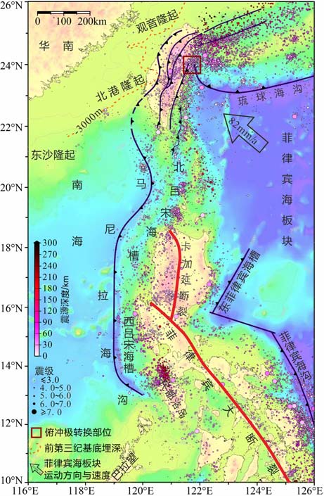
南海作为西太平洋最大的边缘海,其形成演化过程和构造过程独特,长期受到众多学者的关注[1~7].从大的格局上看,南海位于欧亚板块、菲律宾海板块和印度-澳大利亚板块之间.但实际上,南海周边主要由两个刚性块体和一个会聚带所围限.即:北部的华南地块、西部和南部的巽他地块,以及东部的台湾-吕宋会聚带.其中华南地块和巽他地块均被认为是较为稳定的块体,块体内部变形微弱,应变率低,地震活动主要发生于块体边界处,块体内部仅有少量浅源小震[8~11].相比之下,南海东部的台湾-吕宋会聚带包含了板块斜向俯冲、弧陆碰撞造山、洋中脊俯冲、双俯冲带、俯冲极转换等多种情形(图 1),成为南海4个边界中构造最复杂的一个.该会聚带内第四纪以来的火山众多、地震活动频繁密集[12, 13],加之菲律宾大断裂的高速左旋走滑[14, 15],因此也是构造最活跃的一个边界.

|
图 1 研究区大地构造背景与地震活动性台湾岛及附近构造要素据Lin等[21],下同;震中数据来自USGS Fig. 1 Geological settings and seismicity of the research area Tectonics in and around Taiwan Island after Lin et al [21];earthquake data from USGS |
对台湾-吕宋会聚带构造活动的运动学研究,早期主要利用地震滑动矢量来开展[16, 17],以获取板块运动参数,建立板块运动模型.随着GPS 观测技术的应用,学者们开始利用较高精度的观测数据研究板块会聚带的地壳运动与应变特征[14,18~20],并结合天然地震资料分析地壳变形、断裂走滑等构造活动的动力学机制[15, 21~24],为揭示菲律宾海板块与欧亚板块之间的汇聚作用,建立全球板块运动模型提供了重要依据[9].
由于该区复杂的构造背景,使得区内不同区域受控于不同的构造因素.因此,从整体上对台湾-吕宋会聚带进行研究,分析不同构造因素对该区地壳运动的影响就显得非常必要.然而,由于该区观测网的不统一,以及不同观测网覆盖范围和台站密度的差异,限制了从整体上对该区进行地壳运动与动力学机制的研究.
为此,本文收集该区不同观测网获得的地壳运动资料,并合并到统一的参考框架下,对区内不同区域的现时地壳运动特征进行研究,分析块体运动的分区特征,讨论其动力机制,试图藉此为南海的形成演化研究提供约束条件.
2 区域地质概况作为欧亚板块与菲律宾海板块的会聚带,该区东侧的菲律宾海板块以约82mm/a的速率、NW 方向与欧亚板块俯冲汇聚[18];在西侧,西北部的华南地块以10~11 mm/a 的平均速率朝SEE 方向(102°)运动[10, 25],西部-西南部的巽他地块则从北向南分别以6±1 ~ 10±1mm/a的速率向东运动[9].在这一背景下,该区东北部的菲律宾海板块沿琉球海沟斜向插入欧亚板块之下[26];往西侧,吕宋弧与华南陆缘碰撞后隆起造山[27],形成台湾岛东部高耸的纵向山脉.而在这两者之间的区域(24°N 附近),俯冲极发生转换(图 1),形成了一个显着的构造拐点,由其东侧的菲律宾海板块向欧亚板块俯冲,转换为其南侧后者对前者的俯冲,同时在台湾岛东侧的花莲至吕宋岛北部海域发育了洋内俯冲-弧陆碰撞等一整套俯冲带构造景观[28].
继续往南,则在吕宋岛两侧发育了对倾的双俯冲带:东侧菲律宾海板块沿东菲律宾海沟-菲律宾海槽西向俯冲,西侧南海洋壳沿马尼拉海沟东向俯冲[13];而在菲律宾群岛内部,NW 向的菲律宾大断裂贯穿南北,两侧的块体沿该断裂大幅左旋走滑[14, 15, 29].该区复杂的构造边界,甚至使得菲律宾海板块与欧亚板块在该处的界限划分问题出现争议[29~31].
3 数据来源与处理方法本文收集研究区的GPS 观测资料进行地壳运动特征研究,所获得的结果利用GMT 软件[32]绘制成图.本文所使用的数据来自于以下观测网:(1)台湾地区观测网,覆盖台湾本岛以及金门、澎湖、东沙等地[21];(2)台湾-吕宋地区观测网,主要覆盖台湾岛和菲律宾群岛的中北部[14, 15];(3)吕宋观测网,覆盖菲律宾群岛[22];(4)中国地壳运动观测网络(CMONOC),覆盖中国大陆[8, 33, 34];(5)南亚及东南亚GEODYSSEA 观测网[9, 35, 36],其范围覆盖研究区内的吕宋、巴拉望等地.
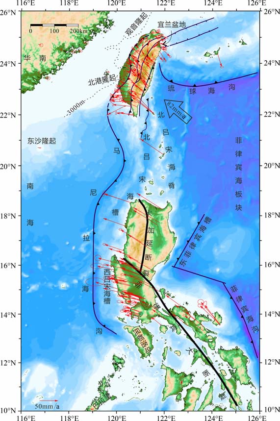
由于这些数据的观测模式、时长,以及参考框架存在差异,本文利用这些数据中的共有台站,在去掉异常站数据后利用GLOBK 软件包合并至ITRF2005[37]框架下,进而转换成欧亚板块参考框架.最终,本文共获得了该区204 个站的速度数据(图 2).在此基础上通过对速度场的E、N 两个分量进行样条插值[38],并以此计算该区的应变场和应变率[39].

|
图 2 台湾一吕宋会聚带的速度场特征以欧亚板块为参照框架,误差椭圆为95%置信度 Fig. 2 GPS velocity field of the research area With respect to the stable Eurasia, error ellipses indicate 95% confidence |
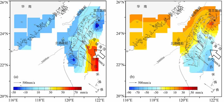
将合并后的速度场转为欧亚板块参考框架下(图 2),并通过样条插值获得连续的分量速度场(图 3,4).结果发现,台湾-吕宋会聚带的地壳运动具有如下特征:

|
图 3 研究区北部的分量连续速度场 (a)WE向速度场;(b)NS向速度场 Fig. 3 Continuous velocity component fields of the research area (a) Velocity field of east-component; (b) Velocity field of north-component |

|
图 4 研究区南部的分量连续速度场 (a)WE向速度场;(b)NS向速度场 Fig. 4 Continuous velocity component fields of the research area (a) Velocity field of east-component; (b) Velocity field of north-component. |
(1) 在台湾-吕宋会聚带的西侧,西北部的华南地块、东沙隆起、北港隆起(澎湖)等地以7~10mm/a的速率往SEE 方向运动,而西南部的巴拉望岛则以9mm/a的速率向95°方向运动(图 2).二者分别代表了华南地块和巽他地块的运动趋势.
(2) 在该会聚带内,北部台湾岛的地壳运动速度场可以分为两个区域(图 3).以24°N 附近的俯冲极转换部位为界,台湾岛北部存在一个呈顺时针旋转的速度场,而南部出现一个以台湾岛东南海岸为中心、向NW-W-SW 方向呈放射状、速率值快速衰减的速度场(图 2).此二者地壳运动特征迥异,显示受控于多个构造因素.
北部的旋转速度场自台东纵谷最北端的花莲附近(俯冲极转换部位南侧)开始,以18~36mm/a的速率沿300°~322°方向运动,速率向NW 方向速度逐渐降低,并且方向不断偏北,到台湾岛西北部速率降为6~10mm/a、方向转为NE(30°~49°).至宜兰盆地以北的台湾岛北部,整体上运动趋势相对较为一致,速率为8~12mm/a、方向NEE(79°~89°).在宜兰盆地内,速度场呈与盆地形状一致的扇形特征,速率为9~21mm/a、方向为61°~114°.宜兰盆地向南至俯冲极转换部位,地壳运动速率由34mm/a逐渐降至19 mm/a,而运动方向则介于134°~148°之间.这表明,宜兰盆地是该区的一个分界点,将顺时针旋转的速度场分成南北两部分.
台湾岛南部的放射状速度场,以东南海岸弧陆碰撞带为中心,速率由东南海岸的64~76mm/a向外递减.受西侧北港隆起的影响,速率在西向上递减迅速,至西部平原区降至<10 mm/a,而在NW 和SW 方向降速相对缓慢(图 2,3),表明北港隆起的阻挡对该速度场的形态有重要影响.
(3) 南部的菲律宾群岛,以卡加延断裂-菲律宾大断裂为界,其东侧的地壳运动表现出与菲律宾海板块近似的特征,沿NNW 向(290°~303°),运动速率介于56~80 mm/a之间.而在该断裂西侧,地壳运动方向整体上较为一致,但相对于东侧略偏西[14](图 2),而且速率也相对要小,介于40~66mm/a之间.该区连续分量速度场则可以清楚地看到,不论东西向还是南北向速度场,都存在一个SW-NE 向的梯度特征(图 4).其中东西向在民都洛岛附近速率最小,吕宋岛北部速度最大(图 4a),表明巴拉望微地块对菲律宾海板块西向运动有明显的阻挡作用[20],而远离巴拉望的吕宋岛北部则具有与菲律宾海板块相近的运动速率.在南北方向,该区西南部靠近南海一侧速率最小,而东南部菲律宾海一侧速率最大.尤其值得注意的是,菲律宾大断裂与该速率方向20~30mm/a的速度带较为一致(图 4b).这些特征表明,菲律宾海大断裂对该区的地壳运动具有显着的调节作用.最近的跨断层剖面的二维弹性位错模型计算发现,菲律宾大断裂的长期滑动速率在北部为24mm/a、中部为37mm/a、南部为40mm/a,自南向北不断减小[15],表明菲律宾大断裂的调节作用在南部最明显,往北西方向趋弱.这一特征或与NW方向的陆缘基底隆起的阻挡有关[12].
5 应变率场为了解该区的应变率特征,本文利用插值后的连续速度场进行了计算(图 5~8).

|
图 5 研究区北部的主应变率场(a)与最大剪应变率(b) Fig. 5 Principle strain rate field (a) and maximum shear strain rates (b) in the north part of research area |

|
图 6 研究区南部的主应变率场(a)和最大剪切应变(b) Fig. 6 Principle strain rate iield (a) and maximum shear strain rates (b) in the south part of the research area |

|
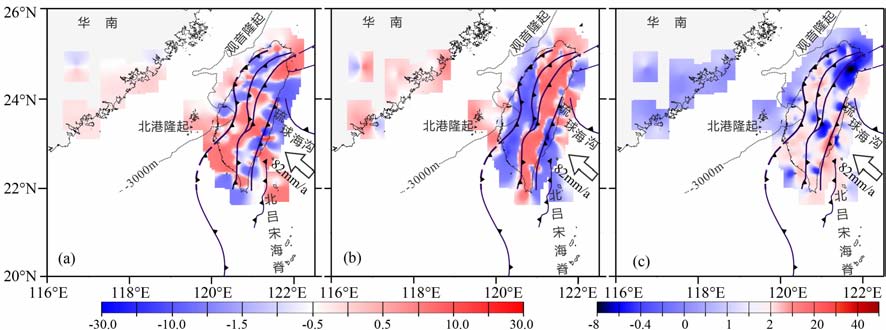
图 7 研究区北部的应变率分量 (a)南北向应变率;(b)东西向应变率;(c)剪应变率 Fig. 7 Strain tensor components in the north part of the research area (a) NS-trending strain rate; (b) EW-trending strain rate; (c) Shear strain rate. |

|
图 8 研究区南部的应变率分量 (a)南北向应变率;(b)剪应变率;(c)东西向应变率. Fig. 8 Strain tensor components in the south part of the research area (a) NS-trending strain rate; (b) EW-trending strain rate; (c)Shear strain rate. |
在研究区北部(图 5a),最大压应变率位于台湾岛东南侧的岛弧碰撞区,其次是位于该碰撞区的NW 和SW 侧的区域.前者是菲律宾海板块NW 高速俯冲导致的弧陆碰撞的结果,后者则是华南陆缘的北港隆起阻挡菲律宾海板块继续向西运动的结果.同时,这些区域也是最大剪应变率的最值区(图 5b).而最大张应变率则位于台湾岛东北的宜兰盆地附近,其北部则是最大剪应变率的低值区,这些特点与宜兰盆地的张性盆地特征一致,显示沿琉球海沟俯冲导致的弧后扩张其影响沿宜兰盆地深入台湾岛北部.在研究区南部,最大压应变率出现在吕宋岛中部菲律宾大断裂附近,而最大张应变率位于吕宋岛中部的西侧(图 6a).与此对应,最大剪应变率的峰值也出现在上述位置,以及民都洛岛与吕宋岛之间的区域(图 6b).
在应变率分量方面(图 7,8),研究区北部的南北向应变率以台湾岛西南侧和东北部宜兰盆地最大,东部沿海碰撞带地区最小(图 7a);东西向应变率呈条带状特征(图 7b),东西两侧弱而中部强;剪切应变则以台湾岛东北部宜兰盆地附近为最小,而最大剪应变率出现在岛弧碰撞带的南端.在研究区南部,应变率的各分量的最大值均位于在吕宋岛中部地区,向南部两侧逐渐减小(图 8).
6 动力学特征通过对台湾-吕宋会聚带的地壳运动与应变率场特征的分析发现,该区内地壳运动可以分成多个区域,对不同区域的动力学机制分析如下:
(1) 以华南地块为核心的部分.这一区域的主体为华南地块,并包括位于华南陆缘之上的观音隆起、北港隆起,以及南海北部陆架上的东沙隆起[21](图 1).印藏碰撞产生的侧向应力传递是主要控制因素,导致华南地块相对于欧亚板块往SEE 方向运动,与NW 向运动的菲律宾海板块在台湾附近发生汇聚.除此之外,该区还应包括台湾岛北部宜兰盆地以北的区域.此前的研究显示,台湾岛北部运动特征与华南地块一致[40].本文的结果表明,这一区域的地壳运动以宜兰盆地为界,其北侧以及北西侧的运动特征与华南陆缘接近,属于华南块体的作用域.
(2) 台湾岛北部,宜兰盆地以南至俯冲极转换部位之间的区域.这一区域的运动特征虽然与琉球群岛不完全一致(图 2,3a),但从动力学角度其运动特征均系因琉球海沟的弧后扩张所致,因此应属于弧后扩张的作用域.菲律宾海板块俯冲极在24°N 附近发生反转,导致该区非但没有受到如俯冲极转换部位南侧的强烈碰撞挤压,反而因琉球海沟的弧后张开影响而形成了向NEE 开口的三角形的宜兰盆地[41].而宜兰盆地的NEE 向张开,导致其北侧的地壳运动方向在由华南沿海传递到此处之后发生轻微的北偏,而南侧区域地壳运动呈现与琉球群岛接近的SSE 方向(图 2).
(3) 台湾岛南部.位于俯冲极转换部位以南的这一区域,东侧受菲律宾海板块(吕宋弧)NW 向高速俯冲碰撞的影响,西侧受华南陆缘北港隆起的阻挡(图 1),导致了该区运动速率由台湾岛东海岸的碰撞带往西迅速降低,并且运动方向呈现放射状(图 2,3),甚至在台湾西南部发生侧向挤出[42~44].
(4) 吕宋岛的东部与西部.吕宋岛以菲律宾大断裂为界,东北侧运动方向NW-NNW,菲律宾海板块的NW 运动为主要动力因素;西南侧运动方向NW-NWW,在受菲律宾海板块的NW 向挤压之外,还受到了巴拉望岛的阻挡作用,使得俯冲带无法快速向西推移,形成了马尼拉海沟南部的大幅弯向SE[45].这也表明,菲律宾大断裂的左旋走滑在会聚带内部有着显着的调节作用[15].因此,从这个角度来看,把整个台湾-吕宋汇聚变形带作为欧亚板块与菲律宾海板块的汇聚边界更合理.
(5) 巴拉望岛.研究表明,位于南海东南部的巴拉望岛其运动特征与巽他地块一致[9].菲律宾群岛的西向仰冲在这里受到阻挡,受其影响,在民都洛岛和吕宋岛之间区域出现了最小东向运动速率(图 4a),以及较高的应变率(图 8).
通过上述分析可以看出,在菲律宾海板块与欧亚板块NW 向高速会聚的大环境下,在台湾-吕宋会聚带存在几个关键构造部位,影响了该区的地壳运动特征:(1)台湾岛东侧24°N 附近的俯冲极转换部位;(2)琉球岛弧的弧后扩张形成的宜兰盆地,与俯冲极转换部位一起将台湾岛的地壳运动速度场分成3个区域;(3)北港隆起,使得台湾南部由东侧的高速碰撞会聚向西迅速降低,并呈发散状,甚至向SW 方向挤出;(4)巴拉望岛,阻挡了菲律宾海板块NW 向高速运动,使得断裂西南侧地壳速率显着下降;(5)菲律宾大断裂,在北部为华南陆缘基底隆起(观音-北港-东沙)、南部为巴拉望岛所阻挡的情况下,为菲律宾海板块的NW 向高速运动提供了一个重要的调节机制.
7 结 论台湾-吕宋会聚带的速度场表现为会聚带西侧的低速(约10 mm/a)东向运动和会聚带东侧的高速(约80mm/a)NW 向运动.在会聚带内则受24°N附近的菲律宾海板块俯冲极转换点、宜兰盆地、台湾西南侧的北港隆起、吕宋岛西南侧的巴拉望岛以及菲律宾大断裂等关键构造部位影响,使得会聚带内不同区域出现了不同的地壳运动和变形特征.
结合会聚带应变率场的分析,可将会聚带划分为6个不同的地壳运动/变形区域:(1)华南地块作用域,范围包括台湾西北部-澎湖-东沙,以及台湾岛北部宜兰盆地以北和北西区域,运动方向SEE;(2)台湾岛俯冲极转换部位以北至宜兰盆地之间区域,以及琉球群岛,受弧后扩张影响,运动方向SE-SSE;(3)台湾岛俯冲极转换点以南,受菲律宾海板块高速俯冲挤压以及西侧北港隆起阻挡影响,运动速率由东侧向西侧沿放射状快速递减,并在南部发生侧向挤出;(4)吕宋岛菲律宾大断裂以东,受菲律宾海板块高速NW 向运动影响,运动方向与菲律宾海板块较为一致;(5)菲律宾大断裂以西,同样受菲律宾海板块高速运动影响,但因西南部受巴拉望阻挡而导致运动速率降低、方向偏西;(6)巴拉望岛,受巽他地块运动影响,运动方向近东向.
致谢本文在对多个速度场进行转换、合并的过程中,RobertW.King博士、董大南教授、田云锋博士提供了无私的帮助,在此表示感谢!
| [1] | Hall R. Reconstructing Cenozoic SE Asia. In: Hall R, Blundell D J, eds. Tectonic Evolution of SE Asia. Geological Society of London Special Publications , 1996, 106: 153-184. DOI:10.1144/GSL.SP.1996.106.01.11 |
| [2] | Hall R. Cenozoic geological and plate tectonic evolution of SE Asia and the SW Pacific: computer-based reconstructions, model and animations. Journal of Asian Earth Sciences , 2002, 20(4): 353-431. DOI:10.1016/S1367-9120(01)00069-4 |
| [3] | Karig D E. Origin and development of marginal basins in the western Pacific. J. Geophys. Res , 1971, 76(11): 2542-2561. DOI:10.1029/JB076i011p02542 |
| [4] | Morley C K. A tectonic model for the Tertiary evolution of strike-slip faults and rift basins in SE Asia. Tectonophysics , 2002, 347(4): 189-215. DOI:10.1016/S0040-1951(02)00061-6 |
| [5] | Taylor B, Hayes D E. The tectonic evolution of the South China Basin. In: Hayes D E, ed. The Tectonic and Geologic Evolution of Southeast Asian Seas and Islands. Geophysical Monograph Series, vol. 23. American Geophysical Union , 1980: 89-104. |
| [6] | Taylor B, Hayes D E. Origin and history of the South China Sea basin. In: Hayes D E ed. The Tectonic and Geologic Evolution of Southeast Asian Seas and Islands, Part 2. Geophysical Monograph Series, vol. 27. American Geophysical Union , 1983: 23-56. |
| [7] | 姚伯初. 南海海盆新生代的构造演化史. 海洋地质与第四纪地质 , 1996, 16(2): 1–13. Yao B C. Tectonic evolution of the South China Sea in Cenozoic. Marine Geology & Quaternary Geology (in Chinese) , 1996, 16(2): 1-13. |
| [8] | Shen Z K, Lü J N, Wang M, et al. Contemporary crustal deformation around the southeast borderland of the Tibetan Plateau. J. Geophys. Res , 2005, 110: B11409. DOI:10.1029/2004JB003421 |
| [9] | Simons W J F, Socquet A, Vigny C, et al. A decade of GPS in Southeast Asia: Resolving Sundaland motion and boundaries. J. Geophys. Res , 2007, 112(B6): B06420. DOI:10.1029/2005JB003868 |
| [10] | Wang Q, Zhang P Z, Niu Z J, et al. Present-day crustal movement and tectonic deformation in China continent. Science in China (Series D): Earth Sciences , 2002, 45(10): 865-874. DOI:10.1360/02yd9085 |
| [11] | 张静华, 李延兴, 郭良迁, 等. 华南块体的现今构造运动与内部形变. 大地测量与地球动力学 , 2005, 25(3): 57–62. Zhang J H, Li Y X, Guo L Q, et al. Contemporary tectionic movement and internal deformation of south China block. Journal of Geodesy And Geodynamics (in Chinese) , 2005, 25(3): 57-62. |
| [12] | Bautista B C, Bautista M L P, Oike K, et al. A new insight on the geometry of subducting slabs in northern Luzon, Philippines. Tectonophysics , 2001, 339(3-4): 279-310. DOI:10.1016/S0040-1951(01)00120-2 |
| [13] | Yang T F, Lee T, Chen C H, et al. A double island arc between Taiwan and Luzon: consequence of ridge subduction. Tectonophysics , 1996, 258(1-4): 85-101. DOI:10.1016/0040-1951(95)00180-8 |
| [14] | Yu S B, Kuo L C, Punongbayan R S, et al. GPS observation of crustal deformation in the Taiwan-Luzon region. Geophys. Res. Lett , 1999, 26(7): 923-926. DOI:10.1029/1999GL900148 |
| [15] | Yu S B, Hsu Y J, Bacolcol T, et al. Present-day crustal deformation along the Philippine Fault in Luzon, Philippines. Journal of Asian Earth Sciences, 2011, doi: 10.1016/j. jseaes.2010.12.007 |
| [16] | Ranken B, Cardwell R K, Karig D E. Kinematics of the Philippine Sea plate. Tectonics , 1984, 3(5): 555-575. DOI:10.1029/TC003i005p00555 |
| [17] | Seno T, Stein S, Gripp A E. A model for the motion of the Philippine Sea plate consistent with NUVEL-1 and geological data. Journal of Geophysical Research-All Serie. , 1993, 98(B10): 17941-17948. DOI:10.1029/93JB00782 |
| [18] | Yu S B, Chen H Y, Kuo L C. Velocity field of GPS stations in the Taiwan area. Tectonophysics , 1997, 274(1-3): 41-59. DOI:10.1016/S0040-1951(96)00297-1 |
| [19] | Chamot-Rooke N, Le Pichon X. GPS determined eastward Sundaland motion with respect to Eurasia confirmed by earthquakes slip vectors at Sunda and Philippine trenches. Earth and Planetary Science Letters , 1999, 173(4): 439-455. DOI:10.1016/S0012-821X(99)00239-3 |
| [20] | Rangin C, Le Pichon X, Mazzotti S, et al. Plate convergence measured by GPS across the Sundaland/Philippine Sea Plate deformed boundary: the Philippines and eastern Indonesia. Geophysical Journal International , 1999, 139(2): 296-316. DOI:10.1046/j.1365-246x.1999.00969.x |
| [21] | Lin K C, Hu J C, Ching K E, et al. GPS crustal deformation, strain rate, and seismic activity after the 1999 Chi-Chi earthquake in Taiwan. J. Geophys. Res , 2010, 115(B7): B07404. DOI:10.1029/2009JB006417 |
| [22] | Galgana G, Hamburger M, McCaffrey R, et al. Analysis of crustal deformation in Luzon, Philippines using geodetic observations and earthquake focal mechanisms. Tectonophysics , 2007, 432(1-4): 63-87. DOI:10.1016/j.tecto.2006.12.001 |
| [23] | Hsu Y J, Yu S B, Kuo L C, et al. Coseismic deformation of the 2010 Jiashian, Taiwan earthquake and implications for fault activities in southwestern Taiwan. Tectonophysics , 2011, 502(3-4): 328-335. DOI:10.1016/j.tecto.2011.02.005 |
| [24] | Wu Y M, Hsu Y J, Chang C H, et al. Temporal and spatial variation of stress field in Taiwan from 1991 to 2007: Insights from comprehensive first motion focal mechanism catalog. Earth and Planetary Science Letters , 2010, 298(3-4): 306-316. DOI:10.1016/j.epsl.2010.07.047 |
| [25] | 周硕愚, 吴云, 施顺英, 等. 中国大陆东南边缘海现时地壳运动与地震动力学综合研究. 地壳形变与地震 , 2001, 21(1): 1–14. Zhou S Y, Wu Y, Shi S Y, et al. Integrated research on current crustal movement and earthquake dynamics in marginal sea, southeast of China continent. Crustal Deformation and Earthquake (in Chinese) , 2001, 21(1): 1-14. |
| [26] | McCaffrey R. Oblique plate convergence, slip vectors, and forearc deformation. J. Geophys. Res , 1992, 97(B6): 8905-8915. DOI:10.1029/92JB00483 |
| [27] | Sibuet J C, Hsu S K. How was Taiwan created?. Tectonophysics , 2004, 379(1-4): 159-181. DOI:10.1016/j.tecto.2003.10.022 |
| [28] | Huang C Y, Yuan P B, Lin C W, et al. Geodynamic processes of Taiwan arc-continent collision and comparison with analogs in Timor, Papua New Guinea, Urals and Corsica. Tectonophysics , 2000, 325(1-2): 1-21. DOI:10.1016/S0040-1951(00)00128-1 |
| [29] | Fitch T J. Plate convergence, transcurrent faults, and internal deformation adjacent to southeast Asia and the western Pacific. Journal of Geophysical Research , 1972, 77(23): 4432-4460. DOI:10.1029/JB077i023p04432 |
| [30] | Cardwell R K, Isacks B, Karig D E. The spatial distribution of earthquakes, focal mechanism solutions, and subducted lithosphere in the Phillippine and northeastern Indonesian island. In: Hayes D E, ed. The Tectonic and Geologic Evolution of Southeast Asian Seas and Islands. Geophysical Monograph Series, vol. 23. American Geophysical Union , 1980: 1-35. |
| [31] | 臧绍先, 陈奇志, 黄金水. 台湾南部—菲律宾地区的地震分布、应力状态及板块的相互作用. 地震地质 , 1994, 16(1): 29–37. Zang S X, Chen Q Z, Huang J S. Distribution of earthquakes, stress state and interaction of the plates in the southern Taiwan-Philippines area. Seismicity and Geology (in Chinese) , 1994, 16(1): 29-37. |
| [32] | Wessel P, Smith W H F. New, improved version of Generic Mapping Tools released. EOS Transactions , 1998, 79(47): 579. DOI:10.1029/98EO00426 |
| [33] | Ma Z J, Chen X L, Ye S H, et al. Contemporary crustal movement of continental China obtained by Global Positioning System (GPS) measurements. Chinese Science Bulletin , 2001, 46(18): 1552-1554. DOI:10.1007/BF02900579 |
| [34] | Gan W J, Zhang P Z, Shen Z K, et al. Present-day crustal motion within the Tibetan Plateau inferred from GPS measurements. J. Geophys. Res , 2007, 112: B08416. |
| [35] | Wilson P, Rais J, Reigber C, et al. Study provides data on active plate tectonics in Southeast Asia region. EOS Transactions , 1998, 79(45): 545. DOI:10.1029/98EO00398 |
| [36] | Michel G W, Yu Y Q, Zhu S Y, et al. Crustal motion and block behaviour in SE-Asia from GPS measurements. Earth and Planetary Science Letters , 2001, 187(3-4): 239-244. DOI:10.1016/S0012-821X(01)00298-9 |
| [37] | Altamimi Z, Collilieux X, Legrand J, et al. ITRF2005: A new release of the International Terrestrial Reference Frame based on time series of station positions and Earth Orientation Parameters. J. Geophys. Res , 2007, 112(B9): B09401. |
| [38] | Wessel P, Bercovici D. Interpolation with splines in tension: A Green's function approach. Mathematical Geology , 1998, 30(1): 77-93. DOI:10.1023/A:1021713421882 |
| [39] | Hackl M, Malservisi R, Wdowinski S. Strain rate patterns from dense GPS networks. Nat. Hazards Earth Syst. Sci , 2009, 9(4): 1177-1187. DOI:10.5194/nhess-9-1177-2009 |
| [40] | 李延兴, 胡新康, 李智, 等. 台海地区的地壳运动与变形. 地震学报 , 2002, 24(5): 487–495. Li Y X, Hu X K, Li Z, et al. Crustal movement and deformation in Taiwan and its coastal area. Acta Seismologica Sinca (in Chinese) , 2002, 24(5): 487-495. |
| [41] | Angelier J, Chang T Y, Hu J C, et al. Does extrusion occur at both tips of the Taiwan collision belt? Insights from active deformation studies in the Ilan Plain and Pingtung Plain regions. Tectonophysics , 2009, 466(3-4): 356-376. DOI:10.1016/j.tecto.2007.11.015 |
| [42] | Hu J C, Hou C S, Shen L C, et al. Fault activity and lateral extrusion inferred from velocity field revealed by GPS measurements in the Pingtung area of southwestern Taiwan. Journal of Asian Earth Sciences , 2007, 31(3): 287-302. DOI:10.1016/j.jseaes.2006.07.020 |
| [43] | Lacombe O, Mouthereau F, Angelier J, et al. Structural, geodetic and seismological evidence for tectonic escape in SW Taiwan. Tectonophysics , 2001, 333(1-2): 323-345. DOI:10.1016/S0040-1951(00)00281-X |
| [44] | Mouthereau F, Lacombe O. Inversion of the Paleogene Chinese continental margin and thick-skinned deformation in the Western Foreland of Taiwan. Journal of Structural Geology , 2006, 28(11): 1977-1993. DOI:10.1016/j.jsg.2006.08.007 |
| [45] | Yumul G P Jr, De Jesus J V, Jimenez F A Jr. Collision boundaries along the western Philippine archipelago. Gondwana Research , 2001, 4(4): 837-837. DOI:10.1016/S1342-937X(05)70618-3 |
 2011, Vol. 54

