2. 东北石油大学地球科学学院,大庆市 163318;
3. 中国石化河南油田分公司石油物探技术研究院,南阳市 473132
2. Northeast Petroleum University, Daqing 163318, China;
3. Petroleum Geophysical Prospecting Technology Research Institute of Henan Oilfield Branch Company, SINOPEC, Nanyang 473132, China
关于莫霍面性质一直存在争议,两种代表性的观点,即化学(岩性)间断面[1~3]和物理“相变"面[4~7]学说.青藏高原是地球上正在进行的陆陆碰撞形成的造山带,但是迄今为止其碰撞过程(包括地点、时间和方式)问题并没有得到完满解答.青藏高原莫霍面的深度及其横向变化、壳幔界面的精细结构是揭示岩石圈动力学过程的重要参数.
中外科学家在青藏高原进行了大量的地球物理工作,为青藏高原地区动力学过程研究提供了可靠的地球物理学证据.由全球地震台网记录的天然地震资料(面波、体波)给出的速度图像显示青藏高原地壳厚度约为70km[8~10].天然地震层析成像方法对界面不敏感,不能直接对莫霍面成像,但可以间接反映莫霍面形态的三维变化[11~13].羌塘块体的地壳厚度约为70km ,且具有低速特征;从金沙江缝合带(JS)到柴达木盆地地壳及岩石圈逐渐变薄,且具有高速特征[14, 15].青藏高原的南缘(拉萨以南)和北缘(格尔木)的地壳尺度内分别存在向高原内倾斜的构造[16].高原南部存在向北倾斜的高速体[17];而高原北部存在向南倾的高速体[18],它们被认为分别是向北俯冲的印度板块岩石圈和柴达木地块(古亚洲) 岩石圈.接收函数方法的提出和应用[19~26]是天然地震研究地球内部结构领域的一项重要进展,能够清晰地揭示莫霍面的形态.近些年进一步发展了接收函数叠加与偏移技术,利用它不仅能显示PS波转换界面的深度、形态,还能进一步给出界面连续性及其横向变化的提示信息.宽频带地震接收函数分析显示,在青藏高原南部莫霍面自喜马拉雅山开始向北缓倾,在雅鲁藏布江缝合带(YZS)附近达到最大深度[27].在青藏高原北部,至少从金沙江缝合带到柴达木南缘,莫霍面一直向南缓倾[28~30].青藏高原Pn波速度在8.1~8.4km/s之间[31~35].青藏高原西部的远震接收函数成像结果显示,莫霍面在羌塘地体的西部最深达到90km, 并且在阿尔金断裂和班公湖-怒江缝合带(BNS)下部快速升高~20km 和~10km.Wittlinger等对HI-CLIMB数据进行处理[36],并对YZS附近“doublet"[37, 38]性质进行了详细讨论.
壳内速度间断面的详细划分以及划分的精度和准确性一直是由深地震反射剖面完成的,然而在青藏高原地区因为人工源能量弱、排列不够长,亦或其它因素造成观测结果不理想,表现为来自地壳底部莫霍面界面的反射波组Pm 震相模糊,或者不能连续追踪识别;不能连续追踪来自上地幔顶部的弱折射波组Pn 震相;壳内反射波组Pg 震相可识别性差,干扰严重[39~43].
本文根据Hi-CLIMB 宽频带三分量地震波形记录,应用转换函数以及模拟退火算法,对青藏高原中部地壳速度结构进行反演,并与接收函数偏移成像方法得到的结果进行对比和讨论,为进一步研究青藏高原地球动力学过程提供了新的地球物理学证据.
2 数据和方法本文研究区域位于N 28°~ N34°与E82°~E88°之间(图 1),数据来源于IRIS 网站,即HI-CLIMB 计划,该计划观测时间自2002 年9 月至2005年12月,由于记录时间比较长,能够获取足够的满足要求的地震记录.

|
图 1 HICLIMB测线位置 YZS—雅鲁藏布江缝合带 Yarlung Zangbo River Suture zone, BNS—班公一怒江缝合带 Bangong-Nujiang Suture zone,JS — 金沙江缝合带Jinshajiang Suture zone,AKMS—阿尼玛卿一昆仑 —木孜塔格缝合带 Animaqing-Kunlun-Muzitage Suture zone. Fig. 1 ICLIMB project distribution |
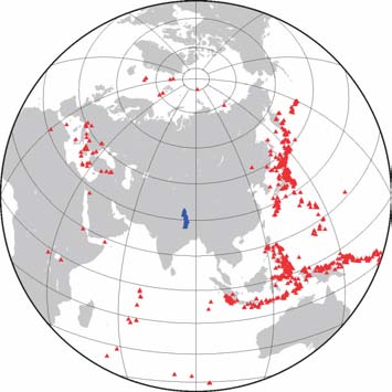
本文采用模拟退火算法进行转换函数波形反演,得到83个台站(编号为0670-1630)下S波速度结构.该方法以广义Boltzmann-Gibbs统计理论为基础,采用依赖于温度的似Cauchy 分布产生新的扰动模型,在高温情况下进行大范围的搜索,在低温时搜索仅在当前模型附近进行,因似Cauchy 分布有一平坦的“尾巴",使其易于迅速跳出局部极值,提高收敛速度,并能在全局找到最优解[44].通过中国及临区地壳结构研究结果显示,该方法是稳定可靠的[45~47].用转换函数方法研究地壳结构,要求台站下方的P波入射角很小,因此需挑选远场(震中距30°<Δ<90°)条件下的地震事件.同时,为保证反演的可靠性,从理论上讲应均匀选择不同方位的震源,虽然接收到的地震事件主要来自于东南亚和东北亚,但亦尽量选取多个方位的震源,所选取的地震事件分布如图 2所示.在实际选择中采取两个步骤,首先挑选出可能符合要求的地震事件,然后再根据实际需要和波形记录质量挑选实际采用的事件.根据经验,要得到比较理想的结果,一般要有20 个以上的有效记录,从实际操作中,除了考虑方位角和震中距外,波形的质量至关重要,否则会引起结果的失真.由于壳幔边界速度差异大,莫霍面产生三个主要震相(Pms、PpPms和PpSms+PsPms)的走时仅与台站下的莫霍面深度、速度有关.选取这三个震相清晰的接收函数,采用H-k(H表示深度,κ 表示纵波与横波波速比)域加权叠加方法来估算地壳厚度和壳内纵横波速比[48].因此根据H-κ 方法初步得到地壳厚度,并将此厚度引入反演结果,做为莫霍面深度判断的条件之一;根据转换函数反演结果Vs>4.4km/s、横波速度具有明显跳跃增加、且在一定深度范围内稳定或变化很小的界面作为莫霍面的另一判断条件.
|
图 2 台站与地震事件分布图.红色三角 代表地震事件,蓝色三角代表台站 Fig. 2 Stations and earthquakes distribution. Red triangles denote earthquakes,and blue triangles denote receiver stations |
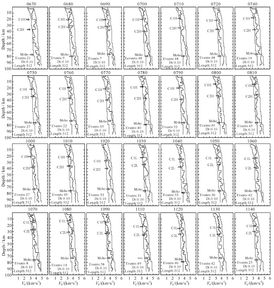
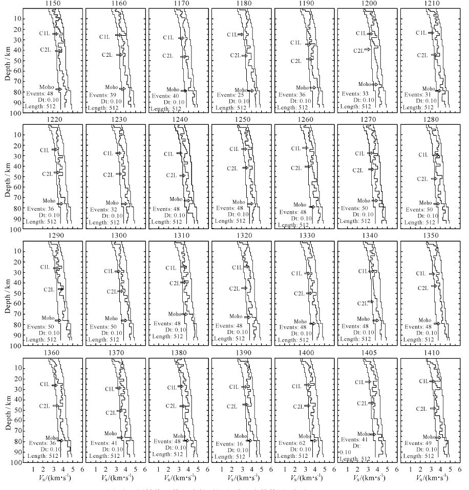
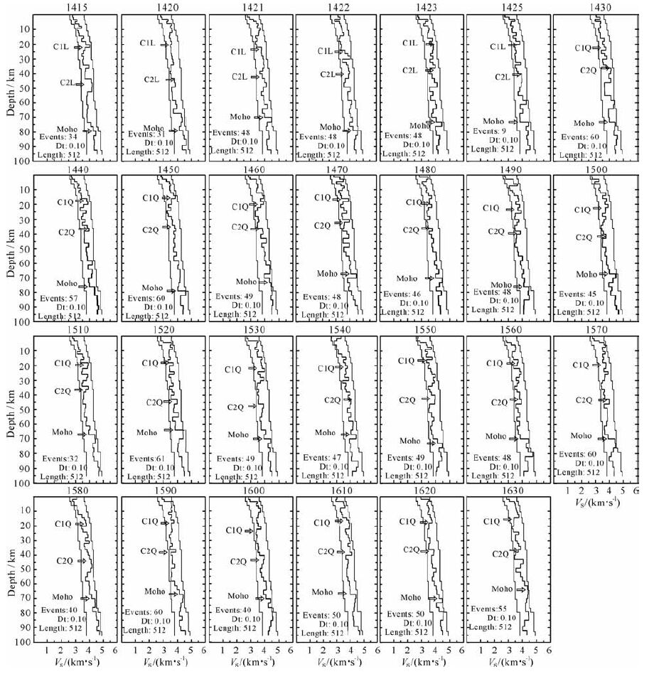
用转换函数方法反演得到的83个台站下方地壳S波速度结果如图 3所示.按照莫霍面深度评判条件确定莫霍面位置,得到台站下莫霍面深度或地壳厚度变化分布.莫霍面在YZS附近达到最深80km, 羌塘地体内莫霍面略有抬升,平均深度为65km.根据地表缝合带位置,将青藏高原由南至北分为:喜马拉雅、拉萨、羌塘、金沙江、喀喇昆仑5个地体,该剖面经过了喜马拉雅地体、拉萨地体、羌塘地体,因此按照台站位置,也相应划分为3 部分:CH(喜马拉雅)、CL(拉萨)和CQ(羌塘),每部分地壳均划分为上、中、下地壳,壳内分界面分别为:喜马拉雅地体内为C1H(上、中地壳分界面)和C2H(中、下地壳分界面);拉萨地体内为C1L(上、中地壳分界面)和C2L(中、下地壳分界面);羌塘地体为C1Q(上、中地壳分界面)和C2Q(中、下地壳分界面).喜马拉雅地体北段上地壳厚度平均为20km, 中地壳厚度平均为20~25km, 下地壳平均厚度为20km, 下地壳存在明显的低速层;拉萨地体上地壳平均厚度为18~25km, 中地壳平均厚度为10~15km, 下地壳平均厚度为30km, 属于巨厚的下地壳,并且壳内分界面不明显;羌塘地体南段上地壳平均厚度为15~22km, 最薄;中地壳平均厚度为25km, 并有明显的低速层;下地壳平均厚度为25km.从整体看,中、下地壳局部存在几个不连续的、小尺度的低速异常体.
|
图 3a 用转换函数方法得到的S波速度结构图(台站0670〜1140). Events为反演计算时使用的地震记录数,Dt为资料 采样间隔(单位s),Length为采样长度(点数).C1H、C2H表示喜马拉雅地体地壳内S波速度分界面,C1L、C2L表示拉萨 地体地壳内S波速度分界面,C1Q、C2Q表示羌塘地体地壳内S波速度分界面 Fig. 3a S-wave velocity structurebelow the stations obtained from transform function method (Station 0670 〜1140).Events indicates the number of the seismic records used in invertcalculation,Dt is the sampling interval of records(s),and Length is the sample length (number). C1H andC2H,C1L andC2L,C1QandC2Q denote S-wave interfaces in Himalayan,Lhasa and Qiangtang block crust,respectively |
|
图 3b 用转换函数方法得到的S波速度结构图(台站1150〜1410) Fig. 3b S-wave velocity structure belowthe stations obtained from transformfunctionmethod (Station 1150〜1410) |
|
图 3c 用转换函数方法得到的S波速度结构图(台站1415〜1630) Fig. 3c S-wave velocity structure below the stations obtained from transform function method (Station 1415〜1630) |
在下地壳倾斜条件下(Nabelek 等的结果[49]),莫霍面反演受到影响,如在接收函数偏移中莫霍面不清晰的地方(N31.5°~N33°之间),造成反演结果中莫霍界面不理想,根据H-κ 结果、CCP(Common Converted Point 成像)结果,对有速度跳跃且速度稳定或正常梯度情况下判断为莫霍面.
为得到光滑的二维速度剖面,首先对转换函数反演的一维速度进行平滑,然后进行空间二维线性插值,得到沿纬度分布的二维速度结构图像.如图 4a所示.

|
图 4 (a)用转换函数方法得到的S波速度二维结构;(b)壳内结构示意图.绿色或蓝色椭圆区域表示壳内低速区,白色箭 头指示物质运移方向,黑色箭头指示有地幔物质进人到下地壳,红色椭圆表示下地壳物质塑性变形,黑色矩形表示刚性、 脆性物质变形;(c)接收函数CCP成像图(摘自JohnNdbglekl,2009[49]),图形上部蓝色虚线是台站高程,黑线是测线平均高程,红线代表莫霍面深度 Fig. 4 (a)S-wave two-dimensional velocity section below the stations obtained from transform function method; (b) Interpretative section of crust. Green or blue elliptic zones show low velocity zones,whitearrows indicate material migration and deformation direction ,black arrow shows mantle material maybe squeeze into the lower crust,red ellipses stand for plastic deformation ,while black rectangles for rigid or brittle deformation; (c) CCP section (from John Nabelekl,2009[49]). The top of the figure shows the station altitude (blue dashes),average topography (black line),and Moho depth (red line) |
从图中可以看出拉萨地体(YZS 和BNS 之间)及YZS以南上地壳(绿色部分)厚度平均为20km, 含有少量部分高速体(浅蓝色部分),并向北倾,最厚达25km, S波速度低于3.6km/s;羌塘地体上地壳厚度平均为15km.拉萨地体中地壳较薄(蓝色部分),S波速度为3.6~3.8km/s, 表现为北倾;羌塘地体中地壳较厚,S波速度以低于3.8km/s为主.拉萨地体下地壳较厚(黄色部分),S波速度为3.9~4.3km/s, 地壳内界面表现为相向俯冲构造,莫霍面深度为70~75km;羌塘地体下地壳厚度较薄,S波速度为3.9~4.3km/s, 并以高速为主,莫霍面深度为65km.在N31.5°~N33°,莫霍面模糊不光滑.
3.2 结果评价为验证反演结果的可靠性,采取统计学中自助法(Bootstrap)和交叉验证(Cross-validation)两种方法对不同台站进行了反演结果评价.在自助法中,对初始模型给一随机扰动,抽取每个台站部分地震事件转换函数,组成小样本空间进行多次反演实验,根据方差的估计构造置信区间,从而得到其解的稳定程度.在交叉验证循环估计法中,对每个台站的转换函数作为数据体中的n个样本,每个样本单独作为一次反演,剩余n-1个样本则作为训练集.每一回合中几乎所有的样本皆用于训练模型,因此最接近母体样本的分布,估测所得的误差比较可靠.为降低该方法的计算成本,本文中选择部分数据参与运算,一般为12~15个转换函数作为样本空间.反演结果Vs误差范围在±0.13km/s, 莫霍面及壳内分界面深度分辨率为±2km, 证明本研究所采用的反演方法和获得的速度结果是可信的.
3.3 结果对比接收函数CCP成像结果(图 4c)能够直观地显示壳内界面[49],但不能显示速度信息,转换函数反演结果能够更好地揭示壳内S-波速度结构细节,特别是对壳内界面与低速带的划分,在纵向上有更高的分辨率,然而因为在反演时平均了来自各个方位不同事件的转换函数,对壳内界面横向起到了平滑作用,降低了横向分辨率.转换函数结果中壳内界面与接收函数偏移结果吻合较好,特别是莫霍面与壳内一级分界面的展布情况类似,并且YZS附近下地壳低速体,以及BNS附近中地壳低速体的位置也与接收函数中负振幅异常区域一致.在N31.5°~N33°之间,转换函数结果,莫霍面模糊不光滑,其主要原因是反演数据主要来自北方地震事件,这与来自北方地震事件的接收函数偏移成像结果一致.
地壳平均泊松比的变化与许多地球物理和地球化学因素有关.其中部分熔融对P 波和S波速度比有很大的影响,地震波速比值随着熔融体熔融程度的增加而增大,已有的地球物理资料证明青藏高原中上地壳泊松比为0.20~0.24,可能为长英质岩石组成;在kind[28]等的结果中,表明青藏高原地壳平均泊松比(0.26~0.29)整体都较高,结合岩石熔融实验研究结果,可以推断工作区中下地壳存在流体和部分熔融岩浆.此结论还得到了大地电磁、Lg波衰减研究、深反射以及宽角反射等研究的支持[50~52].在Hi-CLIMB研究结果中,未见广泛存在的下地壳流证据[49].在我们的反演结果中,只有在BNS以北,速度倒转的中地壳范围较大,存在部分熔融的可能性,而其他部分速度倒转范围较小.
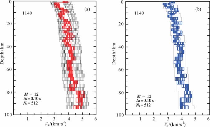
|
图 5 用自助法(a)和交叉验证法(b)验证1140台站的反演结果.M为反演计算时 使用的地震记录数,$\vartriangle t$为资料采样间隔,Nt为采样长度 Fig. 5 The Bootstrap(a) and Crosi-validation(b) test for resolution of the inversed results at station 1140. M indicates the number of the seismic records used in invert calculation,$\vartriangle t$ is the sampling interval of records,and Nt is the sample length |
莫霍面几何形态东西向差异性小.远震P 波接收函数对S波速度较为敏感,偏移成像能够真实地反映莫霍面形态特征.结合INDEPH 和ANTILOPEⅠ、Ⅱ等接收函数结果[53~57],以及前人层析成像、噪音成像等结果[58, 59],在青藏高原中部E82°~E92°范围内,YZS和BNS附近存在莫霍面不连续特征,表明该区域内莫霍面形态特征差异性较小.
碰撞过程与壳内物质运移、厚度变化及高原抬升的关系.拉萨地体上地壳最厚,喜马拉雅地体上地壳次之,羌塘南段上地壳最薄;羌塘南段中地壳最厚,拉萨地体中地壳次之,喜马拉雅中地壳最薄;拉萨地体下地壳最厚,羌塘南段下地壳次之,喜马拉雅下地壳最薄.此构造格局的形成与欧亚板块与印度板块碰撞过程以及各个块体物理性质密不可分.作为这一现象的一种解释是,欧亚板块与印度板块碰撞过程中,使得夹在中间的拉萨地体强烈变形增厚,导致拉萨地体内地壳随着深度的增加,其横向范围缩短,在N31.5°附近中地壳具有速度倒转特征,根据不清晰的莫霍面形态和下地壳倾斜特征,说明此处为印度与欧亚板块碰撞交汇线,拉萨地体地壳物质沿该处莫霍面间断位置挤入地幔,在地幔下沉的同时,部分地幔物质上涌,对下地壳进行改造(图 4b),造成下地壳以高速为主,中地壳发生部分熔融,而上地壳在南北挤压力的条件下发生堆积增厚,是此处高程明显高于附近的主要原因(图 4b中黑色矩形表示的刚性、脆性变形);来自印度板块物质在下地壳(N30°附近,延伸100 km)发生榴辉岩化[38, 49],具有很强的塑性,塑性增强不仅为壳幔解耦创造了有利条件,而且在南北方向挤压的情况下,易发生物质的纵向生长(图 4b中红色椭圆表示的塑性形变),使得此处地表高程超过附近地区;中西部印度地壳挤入青藏高原,没有在雅鲁藏布江缝合带南侧大量堆积起来,而是沿滑脱层继续挤入拉萨地体,一直到班公-怒江缝合带,受阻于岩石圈巨厚的羌塘地体,部分物质堆积在缝合带南侧形成巨厚地壳,一部分沿缝合带向东、西两侧运移[60];羌塘地体形成年代早于拉萨地体,因此羌塘地壳比喜马拉雅地壳稳定,刚性强,上地壳不易变形,而喜马拉雅地体上地壳则明显增厚.
我们的结果支持高原中部壳内交叉俯冲碰撞模型:来自印度上地壳以水平角度向北运动;中地壳以小角度向北俯冲到拉萨中地壳下,截止到拉萨地体南部;下地壳向北俯冲到拉萨地体之下,终止于拉萨地体中南部,到最大的俯冲深度.来自羌塘地体的上地壳以小角度向南俯冲到拉萨地体上地壳之下;中地壳以近水平角度向南运移与拉萨地体中地壳相接;下地壳则以小角度仰冲,与拉萨地体下地壳相接.
| [1] | 曾融生. 莫霍界面的性质. 地球物理学报 , 1964, 13(2): 180–188. Tseng J S. The nature of the Mohorovii discontinuity. Chinese J. Geophys.( Acta Geophysica Sinica) (in Chinese) (in Chinese) , 1964, 13(2): 180-188. |
| [2] | Ringwood A E. Composition and Petrology of the Earth's Mantle. New York: McGraw-Hilt , 1975. |
| [3] | Prodehl C. Structure of the earth's crust and upper mantle. In: Fuchs K, Soffel H, eds. Landolt-B?rnstein, Group V, Vol. 2 (Geophysics of the Solid Earth, the Moon and the Planets). Berlin: Springer-Verlag, 1984: 97~206 |
| [4] | Hess H H. The AMSOC hole to the Earth's mantle. Trans. Am. Geophys. Union , 1959, 40: 340-345. DOI:10.1029/TR040i004p00340 |
| [5] | Kennedy G C. The origin of continents, mountain ranges and ocean basins. Am. Scientist. , 1959, 47(4): 491-504. |
| [6] | Wyllie P J. The nature of the Moho discontinuity, a compromise. J. Geophys. Res. , 1963, 68: 4611-4620. DOI:10.1029/JZ068i015p04611 |
| [7] | 滕吉文. 中国地球深部结构和深层动力过程与主体发展方向. 地质论评 , 2002, 48(2): 125–139. Teng J W. Deep structure of the earth, deep dynamic process and leading direction in China. Geological Review (in Chinese) (in Chinese) , 2002, 48(2): 125-139. |
| [8] | 姚振兴, 李白基, 梁尚鸿, 等. 青藏高原地区瑞利波群速度和地壳构造. 地球物理学报 , 1981, 24(3): 287–295. Yao Z X, Li B J, Liang S H, et al. On the group velocity of Rayleigh waves and the crustal structure of Qinghai-Xizang Plateau. Chinese J. Geophys. (Acta Geophysica Sinica) (in Chinese) (in Chinese) , 1981, 24(3): 287-295. |
| [9] | 周兵, 朱介寿, 秦建业. 青藏高原及邻近区域的S波三维速度结构. 地球物理学报 , 1991, 34(4): 426–441. Zhou B, Zhu J S, Chun K. Three dimensional shear velocity structure beneath Qinghai-Tibet and its adjacent area. Chinese J. Geophys. (Acta Geophysica Sinica) (in Chinese) (in Chinese) , 1991, 34(4): 426-441. |
| [10] | 庄真, 傅竹武, 吕梓龄, 等. 青藏高原及邻近地区地壳与上地幔剪切波三维速度结构. 地球物理学报 , 1992, 35(6): 694–709. Zhuang Z, Fu Z W, Lu Z L, et al. 3-D shear velocity model of crust and upper mantle beneath the Tibetan Plateau and its adjacent regions. Chinese J. Geophys. (Acta Geophysica Sinica) (in Chinese) (in Chinese) , 1992, 35(6): 694-709. |
| [11] | 潘裕生, 汪一鹏, 常承法. 喜马拉雅板块活动证据兼论青藏高原形成模式. 地震地质 , 1980, 2(2): 1–10. Pan Y S, Wang Y P, Chang C F. Evidence of plate activity in Himalayas and a model for formation of Qinghai-Xizang Plateau. Seismology and Geology (in Chinese) (in Chinese) , 1980, 2(2): 1-10. |
| [12] | 常承法, 潘裕生, 郑锡澜, 等. 青藏高原地质构造. 北京: 科学出版社, 1982 . Chang C F, Pan Y S, Zheng X L, et al. The Geological Tectonics of Qinghai-Xizang (Tibet) Plateau (in Chinese). Beijing: Science Press, 1982 . |
| [13] | 曾融生, 丁志峰, 吴庆举. 喜马拉雅-祁连山地壳构造与大陆-大陆碰撞过程. 地球物理学报 , 1998, 41(1): 49–60. Zeng R S, Ding Z F, Wu Q J. The crustal structures from Himalaya to Qilian and its implications for continent collision process. Chinese J. Geophys. (Acta Geophysica Sinica) (in Chinese) (in Chinese) , 1998, 41(1): 49-60. |
| [14] | Wittlinger G, Masson F, Poupinet G, et al. Seismic tomography of northern Tibet and Kunlun: Evidence for crustal blocks and mantle velocity contrasts. Earth and Planetary Science Letter , 1996, 139(1-2): 263-279. DOI:10.1016/0012-821X(95)00235-5 |
| [15] | Wittlinger G, Vergne J, Tapponnier P, et al. Teleseismic imaging of subducting lithosphere and Moho offsets beneath western Tibet. Earth Planet. Sci. Lett. , 2004, 221(1-4): 117-130. DOI:10.1016/S0012-821X(03)00723-4 |
| [16] | 丁志峰, 何正勤, 孙为国, 等. 青藏高原东部及其边缘地区的地壳上地幔三维速度结构. 地球物理学报 , 1999, 42(2): 197–205. Ding Z F, He Z Q, Sun W G, et al. 3-D crust and upper mantle velocity structure in Eastern Tibetan plateau and its surrounding areas. Chinese J. Geophys. (in Chinese) , 1999, 42(2): 197-205. |
| [17] | 吕庆田, 姜枚, 马开义, 等. 三维走时反演与青藏高原南部深部构造. 地震学报 , 1996, 9(4): 583–592. Lü Q T, Jiang M, Ma K Y, et al. Travel time tomography inversion and the deep structure of the southern. Acta Seismologica Sinica (in Chinese) (in Chinese) , 1996, 9(4): 583-592. DOI:10.1007/BF02651048 |
| [18] | 姜枚, 吕庆田, 史大年, 等. 用天然地震探测青藏高原中部地壳、上地幔结构. 地球物理学报 , 1996, 39(4): 470–482. Jiang M, Lü Q T, Shi D N, et al. The study on the structure of crust and upper mantle with natural earthquakes in central Tibetan plateau. Chinese J. Geophys. (Acta Geophysica Sinica) (in Chinese) (in Chinese) , 1996, 39(4): 470-482. |
| [19] | Phinney R A. Structure of the Earth's crust from spectral behavior of long period body waves. J. Geophys. Res. , 1964, 69(14): 2997-3017. DOI:10.1029/JZ069i014p02997 |
| [20] | Langston C A. The effect of planar dipping structure on source and receiver responses for constant ray parameter. Bull. Seism. Soc. Am. , 1977, 67(4): 1029-1050. |
| [21] | Langston C A. Structure under mount rainier, Washington inferred from teleseismic body waves. J. Geophys. Res. , 1979, 84(B9): 4749-4762. DOI:10.1029/JB084iB09p04749 |
| [22] | Owens T J, Zandt G, Taylor S R. Seismic evidence for an ancient rift beneath the Cumberland Plateau, Tennessee: A detailed analysis of broadband teleseismic P waveforms. J. Geophys. Res. , 1984, 89(B9): 7783-7795. DOI:10.1029/JB089iB09p07783 |
| [23] | Owens T J, Taylor S R, Zandt G. Crustal structure at regional seismic test network stations determined from inversion of broadband teleseismic P waveforms. Bull. Seism. Soc. Am. , 1987, 77(2): 631-632. |
| [24] | Cassidy J F. Numerical experiments in broadband receiver function analysis. Bull. Seism. Soc. Am. , 1992, 82(3): 1452-1474. |
| [25] | Ammon C J, Rall G E, Zandt G. On the non-uniqueness of receiver function inversions. J. Geophys. Res. , 1990, 95(B10): 15303-15315. DOI:10.1029/JB095iB10p15303 |
| [26] | Ammon C J. The isolation of receiver effects from teleseismic P waveforms. Bull. Seism. Soc. Am. , 1991, 81(6): 2504-2510. |
| [27] | Yuan X H, Ni J, Kind R, et al. Lithospheric and upper mantle structure of southern Tibet from a seismological passive source experiment. J. Geophys. Res. , 1997, 102(B12): 27491-27500. DOI:10.1029/97JB02379 |
| [28] | Kind R, Yuan X, Saul J, et al. Seismic images of crust and upper mantle beneath Tibet: evidence for Eurasian plate subduction. Science , 2002, 298(5596): 1219-1221. DOI:10.1126/science.1078115 |
| [29] | Kosarev G, Kind R, Sobolev S V, et al. Seismic evidence for a detached Indian lithospheric mantle beneath Tibet. Science , 1999, 283(5406): 1306-1309. DOI:10.1126/science.283.5406.1306 |
| [30] | Galvé A, Hirn A, Mei J, et al. Modes of raising northeastern Tibet probed by explosion seismology. Earth Planet. Sci. Lett , 203(1): 35-43. DOI:10.1016/S0012-821X(02)00863-4 |
| [31] | Holt W E, Wallace T C. Crustal thickness and upper mantle velocity in the Tibetan, Plateau region from the inversion of regional Pn1 waveform: Evidence for a thick upper mantle lid beneath Southern Tibet. J. Geophys. Res. , 1990, 95(B8): 12499-12525. DOI:10.1029/JB095iB08p12499 |
| [32] | 丁志峰, 曾融生, 吴大铭. 青藏高原的Pn波速度和Moho界面的起伏. 地震学报 , 1992, 14(Suppl.): 592–599. Ding Z F, Zeng R S, Wu D M. Pn velocity and Moho variation beneath Tibet plateau. Acta Seismologica Sinica (in Chinese) (in Chinese) , 1992, 14(Suppl.): 592-599. |
| [33] | 吴建平, 叶跃红, 叶太兰, 等. 体波波形反演对青藏高原上地幔速度结构的研究. 地球物理学报 , 1998, 41(Suppl.): 16–25. Wu J P, Ye Y H, Ye T L, et al. Upper mantle velocity structure in the Qinghai-Xizang Plateau from inversion of body waveforms. Chinese J. Geophys. Acta Geophysica Sinica (in Chinese) (in Chinese) , 1998, 41(Suppl.): 16-25. |
| [34] | Wand S Y, Xu Z H, Pei S P. Velocity structure of uppermost mantle beneath North China from Pn tomography and its implications. Science in China Series D: Earth Science , 2003, 46(S2): 130-140. |
| [35] | 姜枚, 许志琴, HimA, 等. 青藏高原及其部分邻区地震各向异性和上地幔特征. 地球学报 , 2001, 22(2): 111–116. Jiang M, Xu Z Q, Hirn A, et al. Teleseismic anisotropy and corresponding features of the upper mantle in Tibet plateau and its neighboring areas. Acta Geoscientia Sinica (in Chinese) (in Chinese) , 2001, 22(2): 111-116. |
| [36] | Kind R, Ni J, Zhao W, et al. Evidence form earthquake data for a partially molten crustal layer in southern Tibet. Science , 1996, 274(5293): 1692-1694. DOI:10.1126/science.274.5293.1692 |
| [37] | Wittlinger G, Farra V. Converted waves reveal a thick and layered tectosphere beneath the Kalahari super-craton. Earth Planet. Sci. Lett. , 2007, 254(3-4): 404-415. DOI:10.1016/j.epsl.2006.11.048 |
| [38] | Wittlinger G, Farra V, Hetényi G, et al. Seismic velocities in Southern Tibet lower crust: a receiver function approach for eclogite detection. Geophys. J. Int. , 2009, 177(3): 1037-1049. DOI:10.1111/gji.2009.177.issue-3 |
| [39] | Zhao W J, Mechie J, Brown L D, et al. Crustal structure of central Tibet as derived from project INDEPTH wide-angle seismic data. Geophys. J. Int. , 2001, 145(2): 486-498. DOI:10.1046/j.0956-540x.2001.01402.x |
| [40] | Zhao W J, Nelson K D, Project INDEPTH Team. Deep seismic reflection evidence for continental underthrusting beneath southern Tibet. Nature , 1993, 366(6455): 557-559. DOI:10.1038/366557a0 |
| [41] | Zhao W J, Nelson K D, Meissner R. Advances of INDEPTH—A deep profiling study in Tibet and the Himalayas. Episodes , 1997, 20(4): 266-272. |
| [42] | 熊绍柏, 刘宏兵. 青藏高原西部的地壳结构. 科学通报 , 1977, 42(12): 1309–1312. Xiong S B, Liu H B. Crustal structure in the west Tibetan plateau. Chinese Science Bulletin (in Chinese) (in Chinese) , 1977, 42(12): 1309-1312. |
| [43] | 卢占武, 高锐, 李秋生, 等. 中国青藏高原深部地球物理探测与地球动力学研究(1958-2004). 地球物理学报 , 2006, 49(3): 753–770. Lu Z W, Gao R, Li Q S, et al. Deep geophysical probe and geodynamic study on the Qinghai-Tibet Plateau (1958-2004). Chinese J. Geophys. (in Chinese) , 2006, 49(3): 753-770. |
| [44] | Zhao L S, Sen M K, Stoffa P, et a1. Application of very fast simulated annealing to the determination of the crustal structure beneath Tibet. Geophys. J. Int. , 1996, 125(2): 355-370. DOI:10.1111/gji.1996.125.issue-2 |
| [45] | 高星, 王卫民, 姚振兴. 中国及临近地区地壳结构. 地球物理学报 , 2005, 48(3): 591–601. Gao X, Wang W M, Yao Z X. Crustal structure of China mainland and its adjacent regions. Chinese J. Geophys. (in Chinese) , 2005, 48(3): 591-601. |
| [46] | Gao X, Su Y L, Wang W M, et al. Lower-crust S-wave velocity beneath western Yunnan Province from waveform inversion of dense seismic observations. Terra Nova , 2009, 21(2): 105-110. DOI:10.1111/ter.2009.21.issue-2 |
| [47] | 王卫民, 苏有亮, 高星, 等. 用转换函数方法研究喜马拉雅地区速度结构. 地球物理学报 , 2008, 51(6): 735–744. Wang W M, Su Y L, Gao X, et al. A study of the velocity structure beneath Himalaya mountain Chain region using transform function method. Chinese J. Geophys. (in Chinese) , 2008, 51(6): 735-744. |
| [48] | Zhu L P, Helmberger D V. Moho offset across the northern margin of the Tibetan plateau. Science , 1998, 281(5380): 1170-1172. DOI:10.1126/science.281.5380.1170 |
| [49] | Nábělekl J, Hetényi G, Vergne J, et al. Underplating in the Himalaya-Tibet collision zone revealed by the Hi-CLIMB experiment. , Science , 2009, 325(5946): 1371-1374. DOI:10.1126/science.1167719 |
| [50] | Wei W B, Unsworth M, Jones A, et a1. Detection of widespread fluids in the Tibetan crust by magnetotelluric studies. Science , 2001, 292(5517): 716-718. DOI:10.1126/science.1010580 |
| [51] | Fan G W, Lay T. Characteristics of Lg attenuation in the Tibetan Plateau. J. Geophys. Res. , 2002, 107(B10): 2256. DOI:10.1029/2001JB000804 |
| [52] | 张中杰, 李英康, 王光杰, 等. 藏北地壳东西向结构与"下凹"莫霍面——来自宽角反射剖面的启示. 中国科学(D辑) , 2001, 31(11): 881–888. Zhang Z J, Li Y K, Wang G J, et al. E-W crustal structure under the northern Tibet and "down-bowing" Moho under the northern Tibet revealed by wide-angle seismic profile. Science in China (Series D) (in Chinese) (in Chinese) , 2001, 31(11): 881-888. |
| [53] | Shi D, Zhao W, Brown L, et al. Detection of southward intracontinental subduction of Tibetan lithosphere along the Bangong-Nujiang suture by P-to-S converted waves. Geology , 2004, 32(3): 209-212. DOI:10.1130/G19814.1 |
| [54] | Tian X B, Wu Q G, Zhang Z J, et al. Joint imaging by teleseismic converted and multiple waves and its application in the INDEPTH-Ⅲ passive seismic array. Geophysical Research Letters , 2005, 32: L21315. DOI:10.1029/2005GL023686 |
| [55] | 吴庆举, 李永华, 张瑞青, 等. 接收函数的克希霍夫2.D偏移方法. 地球物理学报 , 2007, 50(2): 539–545. Wu Q J, Li Y H, Zhang R Q, et al. A feasibility study of cloud base height remote sensing by simulating ground-based thermal infrared brightness temperature measurements. Chinese J. Geophys. (in Chinese) , 2007, 50(2): 539-545. DOI:10.1002/cjg2.v50.2 |
| [56] | Zhao J M, Yuan X H, Liu H B, et al. The boundary between the Indian and Asian tectonic plates below Tibet. Proceedings of the National Academy of Sciences , 107(25): 11229-11233. DOI:10.1073/pnas.1001921107 |
| [57] | 李海鸥, 徐锡伟, 姜枚. 青藏高原中南部的深部地球动力学过程-Hi-Climb 剖面北段接收函数和走时残差分析. 中国科学D辑 , 2008, 38(5): 622–629. Li H O, Xu X W, Jiang M. The Tibet plateau south-central deep geodynamic process-Hi-Climb receive function travel time residual analysis. Science in China Series D: Earth Sciences (in Chinese) (in Chinese) , 2008, 38(5): 622-629. |
| [58] | 钱辉, 姜枚, ChenW P, 等. 青藏高原吉隆-鲁谷(Hi-Climb)层析成像与印藏碰撞的消减作用. 地球物理学报 , 2007, 50(5): 1427–1436. Qian H, Jiang M, Chen W P, et al. Tomography of Gyirong-Lugu profile (Hi-Climb) and the subduction of Indian-Tibet collision. Chinese J. Geophys. (in Chinese) , 2007, 50(5): 1427-1436. |
| [59] | Guo Z, Gao X, Yao H J, et al. Midcrustal low-velocity layer beneath the central Himalaya and southern Tibet revealed by ambient noise array tomography. Geochem. Geophys. Geosyst. , 2009, 10. DOI:10.1029/2009GC002458 |
| [60] | 王椿镛, 楼海, 吕智勇, 等. 青藏高原东部地壳上地幔S 波速度结构—下地壳流的深部环境. 中国科学D辑 , 2008, 38(1): 22–32. Wang C Y, Lou H, Lü Z Y, et al. On the eastern edge of the Tibetan plateau crust mantle S wave velocity structure—a deep crustal flow of the environment. Science in China Series D: Earth Sciences (in Chinese) (in Chinese) , 2008, 38(1): 22-32. |
 2011, Vol. 54

