2. 中国石化国际石油勘探开发公司,北京 100083
2. SINOPEC International Petroleum Exploration and Production Corporation, Beijing 100083, China
南海北部陆缘分布着许多成因相似的新生代沉积盆地,如台西南盆地、珠江口盆地、琼东南盆地、莺歌海盆地、北部湾盆地等.已有研究表明:南海北部陆缘自北向南、由西向东,地壳厚度逐渐减薄;珠江口、琼东南盆地均发育于减薄的过渡型地壳之上.自提出南海中央海盆的地壳为洋壳以来[1],南海的形成和演化机制一直为地球科学界所关注[2~11].关于南海的成因有很多观点,其中最具代表性的有三种:①南海是与印度- 欧亚板块碰撞挤出构造有关的走滑拉分盆地---走滑拉分说[12, 13];② 南海是与太平洋俯冲有关的弧后盆地---弧后盆地说[14~17];③ 南海盆地的形成与地幔柱有关---地幔柱说[18~20].此外,联合机制说认为南海是在多种来源的动力共同作用下形成的[21~24].地壳物理化学属性[25, 26]与岩石组成研究[27, 28]有助于理解南海与南海北部陆缘盆地区的成因.近30 余年来,华南大陆区与南海陆缘区开展了大量的深反射与折射探测[25, 29~51],获得了研究区地壳速度结构与地壳反射性质的系列认识,为研究南海北部陆缘区与华夏地块的关系,以及理解南海北部陆缘区乃至南海的形成提供重要的地球物理约束.
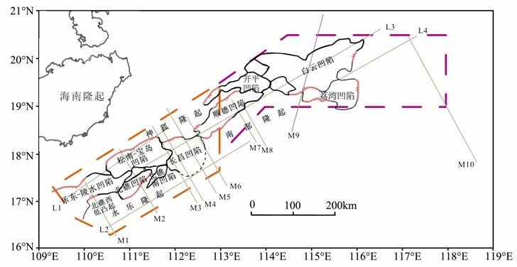
本文利用中海油在珠江口、琼东南盆地已有深反射探测剖面与重力测量资料,采用地震速度结构约束的人机交互重力反演[52]获得研究区地壳密度结构,然后结合地壳速度模型[28]以及全球地壳常见29种岩石的高温高压实验成果[53],推断了琼东南盆地区上地壳岩石组成.测线位置如图 1所示.
2 地壳密度结构与岩石组成研究方法 2.1 地壳密度结构的人机交互重震联合反演地壳密度结构重建方式可归纳为重力单信息反演与重震、重磁等多信息联合反演.重震联合反演适应于重力、地震数据综合解释的需要,是目前可信度最高的定量综合地球物理解释技术.沉积岩中,根据沉积形成的条件差异,可以将整个地质剖面划分为密度与地震波传播速度各异的许多地层.沉积岩中各层波速与岩石密度关系密切,且在一定条件下或特定地区,波速与密度关系可以用某种函数关系近似描述.但是,不同地球物理方法取得的数据量纲不同,精度与灵敏度都有很大差别,因此重震联合反演现在还存在许多难题.例如,场方程与物性/环境方程组量纲完全不同,联立反演,首先要解决归一化问题等等.为此,人们主要采用带先验关系的反演、联合广义反演、人机交互反演三种地震重力联合反演方案.人机交互反演灵活实用,与前两种方法相比,不仅避免了权因子的选取、不要求具有明显函数表示的速度-密度关系,可以避免速度-密度关系的不确定而带来的困难和不足,还具有节省机时与内存的特点.重力反演的目的是计算各层密度,若可能的话,估计由地震数据不能很好定义的那些层的边界.利用经过重力异常改进的深度作为初始深度再做地震反演,如此交替反演、相互印证,直至得出对两种资料都充分拟合的模型参数.本文采用了地震约束条件下的人机交互重力反演.人机交互重震联合反演的关键在于:依据地震成像剖面中地壳分层信息构建重力反演初始模型.文中,由于自由空间重力异常既包含了海水层、海底地形起伏以及浅表地层中不均匀密度体的影响,又包含了深部区域性密度分布不均匀的影响.因此,需要采用合适的方法消除这些因素影响.本文采用了迭代滑动平均法消除自由空间重力异常中的高频干扰,然后采用差值场法取向上延拓10km 后的剩余场作为重力观测值进行重震联合反演.
文中地壳三维密度结构建立思路是:(1)定义多个垂直剖面的位置(图 2a).选用了互相平行的6条测线(图 1 中M5、M1、M2、M3、M4 和M6)和3条与之垂直的测线(L3、L1、L2);(2)设置初始密度模型,即以地震速度模型为依据,确定垂直剖面的位置和数目、不同密度块体的数目、节点与线和线与层的连接关系、剖面上各层内的密度块体编号以及速度-密度经验关系[53]获取初始地壳密度模型;(3)调整初始模型直至计算的与观测的重力布格异常曲线相吻合,获得研究区地壳三维密度结构(图 2b).
|
图 1 珠江口-琼东南盆地深水区位置图 图中实灰线为所用的14条测线位置,虚线标示了深水区西部和东部的两个研究区域. Fig. 1 Map of the deep water area of Pearl River Estuary-Qiongdongnan basin Solid gray line is the location of 14 lines.Dashed 1 i ne shows research region of west and east part of deep water area. |

|
图 2 (a)基于三角网格的重力正演密度建模示意图;(b)三维重力正演方法获得的三维密度结构模型 Fig. 2 (a)Sketch of gravity forward density modeling based on triangle mesh;(b) 3D density structure model acquired by 3D gravity forward method |
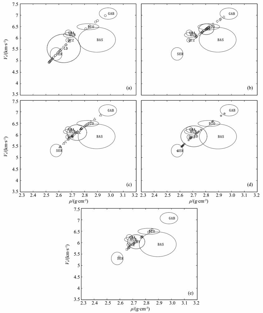
地壳岩石组成是理解地壳岩石圈演化的重要约束,因为地壳与岩石圈演化的过程可能会直接引起岩石组成的变化.基于地球物理资料推断地壳岩石组成是地球物理界关注的重要领域之一[53~57].目前,除了通过地表观测分析出露地球深部物质推测下地壳、上地幔岩石组成之外,地球内部各圈层物质组成研究的主要方案可分为两大类型:(1)根据各圈层密度和地震波速度与地表岩石或矿物的有关性质对比推测各圈层岩石性质(酸性、中性、基性/超基性)或岩石类型;(2)根据各圈层的压力、温度,通过高温高压模拟实验,以泊松比、Vp/Vs 以及拉梅阻抗约束推测岩石组成.文中,以地壳P 波速度和密度数据推断上地壳岩石组成.基于岩相学和地球化学的分析,通过实验测得29 种岩石在地壳50km 深的范围内,密度以及三种不同地温梯度下的纵波速度[53, 58, 59],这为大陆地壳岩石结构的研究提供了完备详实的实验资料.我们从中选取上地壳层中常见的7种岩石(蛇纹岩、花岗片麻岩、石英岩、花岗闪长岩、闪长岩、玄武岩、辉长岩)物性为参考以确定琼东南-珠江口盆地内大型构造单元的岩性.上地壳层岩性分析过程可以总结为:(1)构建区域速度、密度二维模型;(2)利用地壳温压分布与已经出版的热量系数校正每种岩石的纵波速度,利用速度-密度非线性关系[53]计算7 种参考岩石密度值;(3)对于每个构造单元,统计得到岩性参数的平均值以及取值的偏差范围,然后和经过温压校正后的7 种岩石的参数进行对比,以参考岩石的速度-密度相关性做约束,即可得到各构造单元的岩性分布特征.
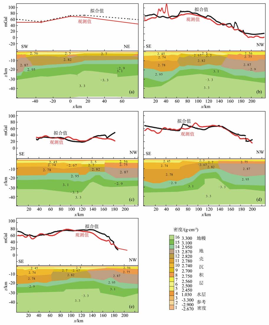
3 琼东南盆地区地壳密度结构我们采用地壳速度模型约束的人机交互重力反演方法,对琼东南盆地区9 条重力观测剖面地壳密度结构进行了反演.进而通过这9 条测线地壳密度数据分析不同深度处琼东南盆地区各凹陷与低隆起区的岩石密度变化情况.限于篇幅,仅展示5条剖面地壳密度结构,见图 3a~3e.
|
图 3 重震联合反演剖面 (a)测线L3;(b)测线M5;(c)测线M1;(d)测线M3;(e)测线M4. Fig. 3 Profile of joint inversion of gravity and seismic (a)L3 line;(b)M5 line;(c)M1 line;(d)M3 line;(e)M4 line. |
测线L3呈北东向展布,剖面长约635.4746km.该测线跨越了珠江口盆地区与琼东南盆地东北部分,该测线重力异常为正异常,异常值变化范围为(28~71)×10-5 m/s2 (图 3a).测线400km内的重力异常起伏变化交迭,异常值起伏较平缓,而在400~600km 内的重力异常值达到极大值,说明琼东南盆地内的各个凹陷与白云凹陷内地壳的密度结构差异很大,是由下地壳层密度的差别引起的.地壳密度反演结果表明下地壳内密度变化范围为2.9~3.1g/cm3,其厚度变化显著,从琼东南盆地区15km 左右增厚至珠江口盆地区的20km 左右.沉积层厚度以重力异常最大值处为界.琼东南盆地区沉积层厚度为3km左右(<2.78g/cm3)而珠江口盆地区为1km 左右.上地壳岩石密度基本上为2.82g/cm3 左右,相对较为均匀分布.
3.1.2 M5线重震联合反演密度结构测线M5呈南北向展布,剖面长约229.47km.M5线重力异常变化范围为(8.4~80)×10-5m/s2,剖面20~40km 段显示出(80~112.2)×10-5m/s2的高重力异常(图 3b).结合区域地质情况推断为新生代玄武岩和少量变质岩的局部影响.尽管25~50km处重力拟合较差,我们推断剩余重力异常可能是由海山地形和玄武岩上升至浅部造成浅层界面起伏引起的,并不影响地壳尺度密度结构的认识.由图 3b地壳密度结构可见,长昌凹陷下方莫霍存在明显上隆现象,长昌凹陷上隆莫霍之间存在镜像关系.壳内密度存在明显的南北向非均一性,沉积层与上地壳内岩石密度存在由北向南逐渐增加趋势,而下地壳内长昌凹陷岩石密度比其南北两侧均大约0.15~0.2g/cm3.顶端地幔物质对长昌凹陷下地壳改造很强烈.
3.1.3 M1线重震联合反演密度结构M1线呈东南向展布,剖面长约147.78km.M1线重力异常值变化范围为(21.6~37.8)×10-5m/s2.距测线北端30~50km 处重力异常值达到局部极大(图 3c).地壳密度结构(图 3c)沿测线南北向变化,以剖面上140km 附近为界,壳内岩石密度差异在上地壳为0.05g/cm3,下地壳达到0.2g/cm3.地壳厚度差异很明显,140km 附近,上地幔顶部隆升幅度达到5~10km.
3.1.4 M3线重震联合反演密度结构M3线呈东南向展布,剖面长约202.19km.M3线重力异常值变化范围为(16.1~77.3)×10-5m/s2.沿该测线重力异常变化剧烈,特别是在剖面60~130km 段内,说明该段壳内界面起伏剧烈,或者地壳岩性组成具有强烈的横向变化.地壳密度结构(图 3d)中,这些重力异常变化特征主要体现在上地壳底部以及下地壳底部的横向起伏.松南-宝岛凹陷的沉积层密度比相邻的长昌凹陷的要大,长昌凹陷沉积层的密度约为2.45g/cm3.但是,长昌凹陷的下地壳层岩石密度较松南-宝岛凹陷的大约0.08g/cm3,其地壳厚度也约厚3~5km.
3.1.5 M4线重震联合反演密度结构M4线呈东南向展布,剖面全长约188.35km.M4线重力异常值变化范围为(20.6~79.3)×10-5m/s2.剖面上0~100km 段,重力异常值为60×10-5m/s2 左右,100~140km 段,重力异常值局部升高,而140km 以南,重力异常值逐渐降低至16.1×10⁻⁵m/s2(图 3e).相应地,地壳密度结构也具有明显的横向非均匀性.地壳内,剖面中段属于高密度、强变形区域.0~100km段较140~202km 段上地壳岩石密度低达0.11g/cm3,下地壳岩石密度低0.05g/cm3.剖面中段地幔顶部上隆现象显著.
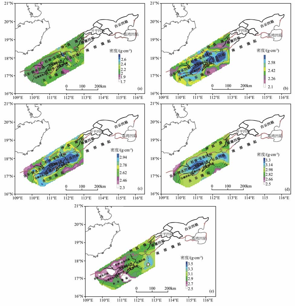
3.2 琼东南盆地区不同深度处岩石密度特征琼东南盆地区凹陷与隆起相间排列,其中包括乐东-陵水凹陷、松南-宝岛凹陷、长昌凹陷、北礁凹陷、顺德凹陷以及永乐隆起、神狐隆起与北礁西低凸起.为了分析不同凹陷与隆起(凸起)区地壳岩石密度分布特征,我们分别展示了不同深度处琼东南盆地区岩石密度结构图像(图 4).整体上地壳岩石密度具有强烈纵横向非均匀性,岩石密度空间变化与凹陷、隆起相间构造格局密切相关.岩石密度结构显示10~22km深度范围盆地区中段具高密度特征,浅于10km 深度内高密度物质弥散分布.其中,由琼东南盆地深度为4km 处密度剖面图(图 4a)可见,松南-宝岛凹陷、长昌凹陷和顺德凹陷的沉积层密度较乐东-陵水凹陷、北礁凹陷的大,密度差值达0.25g/cm3.由图 4b 可见,深度为10km 处,在松南- 宝岛凹陷和长昌凹陷内岩石密度最大,达到2.55g/cm3.由图 4c可见,深度为16km 处,琼东南盆地区中部较之周围具有更高的岩石密度,密度差约为0.1g/cm3.由图 4d可见,深度为22km 处,在松南-宝岛凹陷和顺德凹陷内有最大密度,为3.2g/cm3.由图 4e可见,深度为28km 处,琼东南盆地区东南部岩石密度最大,达到3.0~3.3g/cm3,这说明琼东南盆地东南部在28km 深处已属于岩石圈上地幔;与地壳结构模型相吻合[49, 50, 54, 60, 61].
|
图 4 琼东南盆地密度剖面图 (a)深度为4km 处;(b)深度为10km 处;(c)深度为16km 处;(d)深度为22km 处;(e)深度为28km 处. Fig. 4 Density profile in southeast Hainan basin (a) 4 km depth; (b) 10 km depth; (c) 16 km depth; (d) 22 km depth; (e) 28 km depth. |
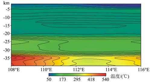
在地壳岩石密度结构重建基础上,利用前述地壳岩石组成推测方案,我们选择琼东南盆地区与油气勘探直接相关的5 个凹陷为研究对象,推测各凹陷上地壳岩石组成.文中,对各个凹陷地壳速度模型与密度模型进行横向平均,然后进行温压校正以便与全球地壳常见7类岩石组成实验结果进行对比.温压校正时,压力采用静岩压力计算方法进行计算.温度场校正时参考了由大洋与大陆岩石圈的热结构恢复方法获得的3SMAC模型,具体模型如图 5所示.
|
图 5 南海北部沿18°N 的温度分布图 Fig. 5 Temperature distribution of northern South China Sea along 18°N |
对比参考岩石的速度-密度相关性,推断乐东-陵水凹陷岩性主要为蛇纹岩、石英岩、花岗片麻岩(图 6a);松南-宝岛凹陷岩性为闪长岩、玄武岩(图 6b);长昌凹陷(图 6c)、顺德凹陷(图 6d)和白云凹陷(图 6e)岩性为花岗片麻岩、石英岩、花岗闪长岩、玄武岩.这些凹陷内上地壳岩石组成推断与研究区已有的岩石物性分析结果[61]相吻合:(1)珠江口盆地是以新生代为主的沉积盆地,沉积岩的物质成分、粒度、孔隙度、流体成分、成岩作用和原始埋深等都影响沉积岩的密度.从岩芯资料来看,本区基底主要由古生代变质岩层、中生代岩浆岩、中生代变质岩、中生代沉积岩组成.珠江口盆地大批钻井钻遇了新生界火山岩,其时代从古新世到第四纪,区内广泛发育火山岩.喜山期岩浆活动是大规模的基性岩浆的喷发和喷溢,早期以广泛的水平玄武岩产出,年龄为22.5~67 Ma;中期岩性主要是玄武岩、拉斑玄武岩和橄榄玄武岩,同位素年龄为2.05~22.5 Ma, 以海山产出.喜山期的基性喷发岩在珠江口盆地主要是喜山早期的玄武岩,而珠江口盆地南部海域主要是喜山中期的拉斑玄武岩和橄榄玄武岩;(2)琼东南盆地基底主要岩性有古生代变质岩、中生代酸性侵入岩、中生代沉积岩、中基性岩浆岩.琼东南盆地始新世拉张开始,先后经历了断陷和拗陷演化阶段,共沉积了上万米新生代碎屑岩.部分钻井资料和地震剖面显示基底为白垩系火山碎屑岩系.重磁分析结果认为,除广大地区基底为白垩系外,还存在大面积的酸性侵入岩,时代推测为中生代晚期,局部地区存在玄武岩,时代可能为新生代晚期.琼东南盆地区内乐水-陵水、松南-宝岛凹陷上地壳玄武岩或玄武岩质岩石的存在支持简单剪切岩石圈伸展模型[62~65],其盆地形成演化受控于低角度拆离断层与地幔挤出构造共同作用.
|
图 6 上地壳层5个凹陷区的速度-密度分布图与上地壳岩石组成推断 (a)乐东-陵水凹陷;(b)松南-宝岛凹陷;(c)长昌凹陷;(d)顺德凹陷;(e)白云凹陷.其中,SER:蛇纹岩; GGN:花岗片麻岩;QTZ:石英岩;GRA:花岗闪长岩;DIO:闪长岩;BAS:玄武岩;GAB:辉长岩. Fig. 6 Velocity-density distribution map of upper crust in five depressions and inferred rock composition (a) Ledong-Lingshui depression; (b) Songnan-Baodao depression; (c) Changchang depression; (d)Shunde depression (e)Baiyun depression.SER: serpentinite; GGN: granitic gneiss; QTZ: quartzite; GRA: granodiorite; DI0: diorite; BAS: basalt; GAB: gabbro. |
以研究区地壳速度结构模型为约束,正演拟合布格重力异常分布,获得了琼东南盆地区地壳密度结构模型.进而,对地壳密度模型进行温压校正,结合地壳速度模型以及全球地壳常见29 种岩石的高温高压实验成果,推断了琼东南盆地区上地壳岩石组成.研究结果表明:
(1) 琼东南盆地区地壳密度结构具有强烈的纵横向非均匀性.4km 深处,沉积中心位于北礁凹陷,长昌凹陷东部,神狐隆起西部与顺德凹陷西部;10km深处存在3个孤立的高密度异常区;16km 深处形成北东走向的高密度异常带;22km 深处存在2个独立的高密度异常区,分界线为长昌凹陷与松南-宝岛凹陷交界处.
(2) 琼东南盆地区内乐水-陵水、松南-宝岛凹陷上地壳岩石组成与其他凹陷具有明显差异,但均存在玄武岩或玄武岩质岩石.支持琼东南盆地形成演化受控于低角度拆离断层作用与地幔挤出构造同时发生的简单剪切岩石圈伸展模型[62~65].
| [1] | Ludwig W J. The Manila Trench and West Luzon Trough-III. Seismic-refraction measurements. Deep Sea Research and Oceanographic Abstracts , 1970, 17(3): 553-562. DOI:10.1016/0011-7471(70)90067-7 |
| [2] | Karig D E. Origin and development of marginal basins in western Pacific. J. Geophys. Res. , 1971, 76: 2542-2561. DOI:10.1029/JB076i011p02542 |
| [3] | Karig D E. Plate convergence between the Philippines and Ryukyu Islands. Mar Geology , 1973, 14: 153-168. DOI:10.1016/0025-3227(73)90025-X |
| [4] | Ben-Avraham Z, Uyeda S. The evolution of the China Basin and the Mesozoic paleography of Borneo. Earth Planet. Sci. Lett. , 1973, 18: 365-376. DOI:10.1016/0012-821X(73)90077-0 |
| [5] | Taylor B, Hayes D E. The tectonic evolution of the South China Sea. In:Hayes D E. The Tectonic and Geological Evolution of Southeast Asia Seas and Islands.AGU. Washington D C: American Geophysical Union, 1980, (23): 89~104 |
| [6] | Taylor B, Hayes D E. Origin and history of the South China Sea basin. In: Hayes D E. The Tectonic and Geological Evolution of Southeast Asian Seas and Islands.AGU. Washington D C: American Geophysical Union, 1983, (27): 23~56 |
| [7] | 何廉声. 南海地质地球物理图集:南海大地构造图. 广州: 广东地图出版社, 1987 . He L S. Atlas of Geology and Geophysics of the South China Sea: Geotectonic Map of the South China Sea (in Chinese). Guangzhou: Guangdong Cartographic Publishing House, 1987 . |
| [8] | 何廉声. 南海的形成、演化与油气资源. 海洋地质与第四纪地质 , 1988, 8(2): 15–28. He L S. Formation and evolution of South China Sea and their relation to oil and gas resources. Marine Geology & Quaternary Geology (in Chinese) , 1988, 8(2): 15-28. |
| [9] | 姚伯初. 南海海盆新生代的构造演化史. 海洋地质与第四纪地质 , 1996, 16(2): 1–13. Yao B C. Tectonic evolution of the South China Sea basin in Cenozoic. Marine Geology & Quaternary Geology (in Chinese) , 1996, 16(2): 1-13. |
| [10] | 张训华, 李延成, 綦振华. 南海海盆形成演化模式初探. 海洋地质与第四纪地质 , 1997, 17(2): 1–7. Zhang X H, Li Y C, Qi Z H. An approach to the formation and evolution model of South China Sea basin. Marine Geology & Quaternary Geology (in Chinese) , 1997, 17(2): 1-7. |
| [11] | 夏斌, 崔学军, 谢建华, 等. 关于南海构造演化动力学机制研究的一点思考. 大地构造与成矿学 , 2004, 28(3): 221–227. Xia B, Cui X J, Xie J H, et al. An approach to the dynamic mechanism study on formation and evolution of the South China Sea. Geotectonica et Metallogenia (in Chinese) , 2004, 28(3): 221-227. |
| [12] | Tapponnier P, Molnar P. Slip-line field theory and large scale continental tectonics. Nature , 1976, 264: 319-324. DOI:10.1038/264319a0 |
| [13] | Tapponnier P, Peltzer G, Le D A Y, et al. Propagating extrusion tectonics in Asia: new insights from simple experiments with plasticine. Geology , 1982, 10: 611-616. DOI:10.1130/0091-7613(1982)10<611:PETIAN>2.0.CO;2 |
| [14] | Aubouin J. Dynamic model of the western Pacific. Tectonophysics , 1990, 183: 1-7. DOI:10.1016/0040-1951(90)90185-B |
| [15] | Hawkins J W, Lonsdale P F, Macdougall J D, et al. Petrology of the axial ridge of Mariana Trough backarc spreading center. Earth Planet. Sci. Lett. , 1990, 100: 226-250. DOI:10.1016/0012-821X(90)90187-3 |
| [16] | Stern R J, Lin P N, Morris J D. Enriched back-arc basin basalts from the northern Marianna Trough: implications for the magmatic evolution of back-arc basin. Earth Planet. Sci. Lett. , 1990, 100: 210-225. DOI:10.1016/0012-821X(90)90186-2 |
| [17] | Lan C Y, Chen C H, Chung S L, et al. The crustal evolution of continental Taiwan. J. Geol. Soc. China , 1996, 39(3): 337-353. |
| [18] | Xie G, Tu K, Wang J W, et al. The geographical distribution and genesis of Pb isotope components from Cenozoic basalts in Eastern China. Chinese Science Bulletin(in Chinese with English abstract) , 1989, 10: 772-775. |
| [19] | Zhu B, Wang H. Nd-Sr-Pb isotope and chemical evidence for the volcanism with MORB-OIB source characteristics in the Leiqiong area, China. Geochimica , 1989, 18(3): 193-201. |
| [20] | Fan W, Amenzies M. The lithospheric mantle composition of volcanism in extension settings: the geochemical evidence of Cenozoic basalts in Leiqiong area. In: Liu R ed. The Ages and Geochemistry of Cenozoic Volcanic Rocks in China. Beijing: Seismological Press , 1992: 320-329. |
| [21] | 周蒂, 陈汉宗, 吴世敏, 等. 南海的右行陆缘裂解成因. 地质学报 , 2002, 76(2): 180–190. Zhou D, Chen H Z, Wu S M, et al. Opening of the South China Sea by dextral splitting of the East Asian continental margin. Acta Geologica Sinica (in Chinese) , 2002, 76(2): 180-190. |
| [22] | 谢建华, 夏斌, 张宴华, 等. 南海形成演化探究. 海洋科学进展 , 2005, 23(2): 212–218. Xie J H, Xia B, Zhang Y H, et al. Study on formation and evolution of the South China Sea. Advances in Marine Science (in Chinese) , 2005, 23(2): 212-218. |
| [23] | 闫义, 夏斌, 林舸, 等. 南海北缘新生代盆地沉积与构造演化及地球动力学背景. 海洋地质与第四纪地质 , 2005, 25(2): 53–61. Yan Y, Xia B, Lin G, et al. The sedimentary and tectonic evolution of the basins in the north margin of the South China Sea and geodynamic setting. Marine Geology & Quaternary Geology (in Chinese) , 2005, 25(2): 53-61. |
| [24] | Xia B, Zhang Y, Cui X J, et al. Understanding of the geological and geodynamic controls on the formation of the South China Sea: a numerical modelling approach. Journal of Geodynamics , 2006, 42: 63-84. DOI:10.1016/j.jog.2006.06.001 |
| [25] | Yan P, Zhou D, Liu Z S. A crustal structure profile across the northern continental margin of the South China Sea. Tectonophysics , 2001, 338: 1-21. DOI:10.1016/S0040-1951(01)00062-2 |
| [26] | Qiu X, Ye S, Wu S, et al. Crustal structure across the Xisha Trough, northwestern South China Sea. Tectonophysics , 2001, 341: 179-193. DOI:10.1016/S0040-1951(01)00222-0 |
| [27] | Zhang Z J, Zhang X, Badal J. Composition of the crust beneath Southeastern China derived from an integrated geophysical dataset. J. Geophys. Res. , 2008, 113. DOI:10.1029/2006JB004503 |
| [28] | Zhang Z J, Chen Q F, Bai Z M, et al. Crustal structure and extensional deformation of thinned lithosphere in Northern China. Tectonophysics , 2010. DOI:10.1016/j.tecto.2010.06.021 |
| [29] | 阎贫, 刘海龄. 南海北部陆缘地壳结构探测结果分析. 热带海洋学报 , 2002, 21(2): 1–12. Yan P, Liu H L. Analysis on deep crust sounding results in northern margin of South China Sea. Tropic Oceanology (in Chinese) , 2002, 21(2): 1-12. |
| [30] | 刘光鼎主编. 中国海区及邻域地质地球物理系列图集. 北京: 科学出版社, 1992 . Liu G D ed. Geophysical Series Maps in China Sea and Adjacent Regions (in Chinese). Beijing: Science Press, 1992 . |
| [31] | 姚伯初, 曾维军, HayesD E, 等. 中美合作调研南海地质专报 , 1994: 75–90. Yao B C, Zeng W J, Hayes D E, et al. The Geological Memoir of South China Sea Surveyed Jointly by China and USA (in Chinese). Wuhan: China University of Geosciences Press (in Chinese) , 1994: 75-90. |
| [32] | 王家林, 吴建生, 陈兵, 等. 珠江口盆地和东海陆架盆地基底结构的综合地球物理研究. 上海: 同济大学出版社, 1995 . Wang J L, Wu J S, Chen B, et al. Comprehensive Geophysical Research on Basement Structure in Zhujiangkou Basin and the Shelf Basin of the East China Sea (in Chinese). Shanghai: Tongji University Press, 1995 . |
| [33] | Wang J L, Chen B, Wu J S, et al. Integrated geological and geophysical research on the base texture and Mesozoic of the sedimentary basin in Chaoshan depression. . |
| [34] | Nissen S, Hayes D, Buhl P, et al. Deep penetration seismic sounding across the north margin of South China Sea. J. Geophys. Res. , 1995a, 100(B11): 22407-22433. DOI:10.1029/95JB01866 |
| [35] | Nissen S, Hayes D, Yao B, et al. Gravity, heat flow, and seismic constraints on the processes of crustal extension: northern margin of South China Sea. J. Geophys. Res. , 1995b, 100(B11): 22447-22483. DOI:10.1029/95JB01868 |
| [36] | 宋海斌, 郝天珧, 江为为. 南海北部张裂边缘的类型及其形成机制探讨. 见:陈颙等编. 寸丹集--庆贺刘光鼎院士工作50周年学术论文集. 北京: 科学出版社, 1998:74~81. Song H B, Hao T Y, Jiang W W. Discussion on type and formation mechanism of the northern margin of the South China Sea. In: Chen Y eds. Cundan Collected Papers in Honour of the 50 Years' Work of Academician Liu Guangding. Beijing: Science Press, 1998:74~81 |
| [37] | 宋海斌, 郝天珧, 江为为, 等. 南海地球物理场特征与基底断裂体系研究. 地球物理学进展 , 2002, 17(1): 24–33. Song H B, Hao T Y, Jiang W W, et al. Research on geophysical field characteristics and basement fault system of South China Sea. Progress in Geophysics (in Chinese) , 2002, 17(1): 24-33. |
| [38] | 丘学林, 施小斌, 阎贫, 等. 南海北部地壳结构的深地震探测和研究新进展. 自然科学进展 , 2003, 13(3): 231–236. Qiu X L, Shi X B, Yan P, et al. Deep seismic sounding and new progress in crustal structure of the northern South China Sea. Progress in Natural Science (in Chinese) , 2003, 13(3): 231-236. |
| [39] | Shi X B, Qiu X L, Xia K Y, et al. Characteristics of surface heat flow in the South China Sea. Journal of Asian Earth Sciences , 2003, 22: 265-277. DOI:10.1016/S1367-9120(03)00059-2 |
| [40] | 赵明辉, 丘学林, 叶春明, 等. 南海东北部深地震联测与滨海断裂带两侧地壳结构分析. 地球物理学报 , 2004, 47(5): 845–852. Zhao M H, Qiu X L, Ye C M, et al. Analysis on deep crustal structure along the onshore-offshore seismic profile across the binhai (littoral) fault zone in northeastern South China Sea. Chinese J. Geophys. (in Chinese) , 2004, 47(5): 845-852. |
| [41] | Zhang Z J, Badal J, Li Y K, et al. Crust-upper mantle seismic velocity structure across Southeastern China. Tectonophysics , 2005, 395: 137-157. DOI:10.1016/j.tecto.2004.08.008 |
| [42] | 郝天珧, 刘建华, 宋海斌, 等. 华南及其相邻边缘海域一些重要断裂的地球物理证据. 地球物理学进展 , 2003, 17(1): 13–23. Hao T Y, Liu J H, Song H B, et al. Geophysical evidence of some important faults in South China and adjacent marginal seas region. Progress in Geophysics (in Chinese) , 2003, 17(1): 13-23. |
| [43] | 郝天珧, 刘建华, 黄忠贤, 等. 中国边缘海岩石层结构研究. 地球物理学进展 , 2004, 19(3): 583–589. Hao T Y, Liu J H, Huang Z X, et al. Research on the lithosphere structure of Chinese Marginal Seas. Progress in Geophysics (in Chinese) , 2004, 19(3): 583-589. |
| [44] | 郝天珧, 黄松, 徐亚, 等. 南海东北部及邻区深部结构的综合地球物理研究. 地球物理学报 , 2008, 51(6): 1785–1796. Hao T Y, Huang S, Xu Y, et al. Comprehensive geophysical research on the deep structure of Northeastern South China Sea. Chinese J. Geophys. (in Chinese) , 2008, 51(6): 1785-1796. |
| [45] | 胥颐, 刘建华, 郝天珧, 等. 中国东部海域及邻区岩石层地幔的P波速度结构与构造分析. 地球物理学报 , 2006, 49(4): 1053–1061. Xu Y, Liu J H, Hao T Y, et al. P wave velocity structure and tectonics analysis of lithospheric mantle in eastern China seas and adjacent regions. Chinese J. Geophys. (in Chinese) , 2006, 49(4): 1053-1061. |
| [46] | 胥颐, 李志伟, 郝天珧, 等. 南海东北部及其邻近地区的Pn波速度结构与各向异性. 地球物理学报 , 2007, 50(5): 1473–1479. Xu Y, Li Z W, Hao T Y, et al. Pn wave velocity and anisotropy in the northeastern South China Sea and adjacent region. Chinese J. Geophys. (in Chinese) , 2007, 50(5): 1473-1479. |
| [47] | Wang T K, Chen M K, Lee C S, et al. Seismic imaging of the transitional crust across the northeastern margin of the South China Sea. Tectonophysics , 2006, 412: 237-254. DOI:10.1016/j.tecto.2005.10.039 |
| [48] | 姚伯初, 万岭, 曾维军, 等. 中国南海海域岩石层三维结构及演化. 北京: 地质出版社, 2006 . Yao B C, Wan L, Zeng W J, et al. Three dimensional lithosphere structure and evolution in South China Sea (in Chinese). Beijing: Geological Publishing House, 2006 . |
| [49] | Zhang Z J, Wang Y H. Crustal structure and contact relationship revealed from deep seismic sounding data in South China. Physics of the Earth and Planetary Interiors , 2007, 165: 114-126. DOI:10.1016/j.pepi.2007.08.005 |
| [50] | 张中杰, 刘一峰, 张素芳, 等. 南海北部珠江口-琼东南盆地地壳速度结构与几何分层. 地球物理学报 , 2009, 52(10): 2461–2471. Zhang Z J, Liu Y F, Zhang S F, et al. Crustal velocity structure and geometric stratification of Pearl River Mouth-Southeast Hainan basin in northern south China Sea. Chinese J. Geophys. (in Chinese) , 2009, 52(10): 2461-2471. |
| [51] | 张中杰, 刘一峰, 张素芳, 等. 琼东南盆地地壳伸展深度依赖性及其动力学意义. 地球物理学报 , 2010, 53(1): 57–66. Zhang Z J, Liu Y F, Zhang S F, et al. The depth-dependence of crustal extension beneath Qiongdongnan basin area and its tectonic implications. Chinese J. Geophys. (in Chinese) , 2010, 53(1): 57-66. |
| [52] | Mike W. Semi-automatic Marquardt inversion of gravity and magnetic profile using Singular Value Decomposition. 1985, USGS open file-report, 85~122 |
| [53] | Christensen N I, Mooney W D. Seismic velocity structure and composition of the continental crust: a global view. J. Geophys. Res. , 1995, 100: 9761-9788. DOI:10.1029/95JB00259 |
| [54] | Rudnick R L, Fountain D M. Nature and composition of the continental crust: a lower crustal perspective. Rev. Geophys. , 1995, 33: 267-309. DOI:10.1029/95RG01302 |
| [55] | Christensen N I. Poisson's ratio and crustal seismology. J. Geophys. Res. , 1996, 101: 3139-3156. DOI:10.1029/95JB03446 |
| [56] | Brown D, Carbonell R, Kukkonen I, et al. Composition of the Uralide crust from seismic velocity, heat flow, gravity and magnetic data. Earth Planet. Sci. Lett. , 2003, 210: 333-349. DOI:10.1016/S0012-821X(03)00143-2 |
| [57] | Vigneresee J L. Heat flow, heat production and crustal structure in Peri-Atlantic regions. Earth Planet. Sci. Lett. , 1988, 87: 302-312. |
| [58] | Hu S B, Xiong L P. Analysis of thermal regime at shallow depth and heat flow correction in Southeast China. In: Proceedings of the 1st Tianjin Geothermal Workshop, 1992:18~23 |
| [59] | 滕吉文, 王谦身, 魏斯禹. 中国地壳构造的基本轮廓. 石油物探 , 1982, 2: 14–30. Teng J W, Wang Q S, Wei S Y. The basic contour map of China crustal structure. Geophysical Prospecting for Petroleum (in Chinese) , 1982, 2: 14-30. |
| [60] | 廖其林, 王振明, 王屏路, 等. 福州-泉州-汕头地区地壳结构的爆炸地震研究. 地球物理学报 , 1988, 31(3): 270–280. Liao Q L, Wang Z M, Wang P L, et al. Explosion seismic study of the crustal structure in Fuzhou-Quanzhou-Shantou region. Chinese J. Geophys. (in Chinese) , 1988, 31(3): 270-280. |
| [61] | 冯志强, 缪宛岑. 南海珠江口盆地地质构造特征和含油气远景. 石油实验地质 , 1982, 4(1): 19–26. Feng Z Q, Miao W Q. The geological structures and the oil and gas potential of the Zhujiangkou basin. Petroleum Geology and Experiment (in Chinese) , 1982, 4(1): 19-26. |
| [62] | Wernicke B. Low-angle normal faults in the Basin and Range Province: nappe tectonics in an extending orogen. Nature , 1981, 291: 645-648. DOI:10.1038/291645a0 |
| [63] | Wernicke B. Uniform-sense simple-shear of the continental lithosphere. Canadian Journal of Earth Science , 1985, 22: 108-125. DOI:10.1139/e85-009 |
| [64] | Wernicke B, Burchfiel B C. Modes of extensional tectonics. Journal of Structural Geology , 1982, 4: 105-115. DOI:10.1016/0191-8141(82)90021-9 |
| [65] | Lister G S, Etheridge M A, Symonds P A. Detachment faulting and the evolution of passive continental margins. Geology , 1986, 14(3): 246-250. DOI:10.1130/0091-7613(1986)14<246:DFATEO>2.0.CO;2 |
 2011, Vol. 54

