 2010, Vol. 53


2. 中国科学院研究生院, 北京 100049;
3. 中国地质博物馆, 北京 100034
2. Graduate University of Academy of Sciences, Beijing 100049, China;
3. Geological Museum of China, Beijing 100034, China
西峡盆地位于河南省西南部(图 1a),自20世纪70年代在上白垩统发现恐龙蛋化石以来,国内外许多学者在此开展了包括生物地层学、古生物学等在内的一系列研究工作[1~13],使得该地区成为国内外地球科学尤其是古生物学研究关注的地区之一.与西峡盆地相关的前人研究资料大都集中于讨论古生物化石尤其是蛋化石形态、结构、分类、演化等方面,继而讨论白垩纪晚期环境演变以及恐龙等大型爬行动物随环境变化而发生绝灭的原因等[1~13].到目前为止,对于盆地内地层精确年代控制的研究涉及很少,一方面可能是困于盆地定年手段及方法的局限性,例如缺乏相应的年代学方法可资利用的定年材料,如火山岩、火山灰[14]等;另一方面选择一条在野外能清晰分辨,且层序也非常连续的地质剖面本身也很困难.此外,虽然能够大致确定盆地内生物化石的剖面时代,但化石本身延续时间跨度较大,大多数生物化石因具有穿时性,导致定年结果较粗糙,想要获得该盆地较精确的年龄框架比较困难.因而盆地内沉积地层及其所含化石年龄的确定,成为亟待解决的科学问题.近年来,随着各学科对地层年代划分的要求越来越精细,作为一种独立于古生物地层学和放射性同位素年代学方法之外的盆地定年方法--磁性地层学已逐步发展成为建立中、新生代沉积地层连续时间框架的可靠手段,在青藏高原北部及中亚地区的新生代地层的定年和动力学研究、陆内盆地定年和古环境研究等领域取得了重要突破[15~24].本文拟通过岩石磁学和系统热退磁分析,利用磁性地层学方法对河南南阳西峡盆地含恐龙蛋化石的阳城-丹水剖面进行研究,为进一步精确厘定该地区含恐龙蛋化石地层的年龄,进而为探索该地区恐龙等大型爬行动物的灭绝历史及机制等提供可靠基础.

|
图 1 研究区剖面地理位置(a)及研究区地质图(1:250000)(b) Fig. 1 Schematic map of the Xixia Basin and the studied section (a) and simplified geological map of the studied area (1:250000) (b) |
豫西南地区白垩系主要分布于伏牛山以南、京广铁路线以西的断陷盆地中.区内下白垩统分布十分有限,而上白垩统则分布广泛;尤以桑坪-夏馆、西坪-赤眉、淅川、郧县盆地为代表,上白垩统发育较为齐全,层序清楚,古生物化石丰富.这些盆地的基本构造格架主要由秦岭主造山期以及后主造山期两期复合构成东西走向,以自北向南为主导的复合型逆冲推覆构造[10]组成.
西峡盆地发育于南阳盆地中(图 1b),本次研究区地理坐标范围:110°E~112°E,33°N~34°N,恐龙蛋化石大量存在于西峡盆地晚白垩世地层中.西峡盆地构造上属于一向斜构造,但由于向斜南西翼地层出露很少,且露头多不连续,表现为有较多缺失.因而,本次研究选择西峡盆地向斜构造北东翼的阳城-丹水剖面(也称红山水库-丹水剖面)作为古地磁采样剖面.盆地地层由底部至顶部(即地层由老至新)共分为四个组[1, 2, 11, 25],分别是桑坪组(原走马岗组下段)、走马岗组(原走马岗组上段)、赵营组和六爷庙组(图 2).其中,桑坪组总厚度210.8 m,与下伏的一套变质石英片岩及黄色片岩为角度不整合接触;整合于其上的走马岗组总厚度840.4m,赵营组总厚度2118.34 m,整合于走马岗组之上;六爷庙组与下伏赵营组为整合接触,总厚度334.113m[1~3].

|
图 2 研究区地层剖面图[2](下方数字代表地层分层层号) Fig. 2 Cross section of the Late Cretaceous succession exposed in the northeastern limb of the Yangcheng-Danshui syncline[2]; Layers bear the dinosaur egg fossils, dinosaur bones, and invertebrate animal fossils are labeled using different symbols respectively |
地质剖面测量以及古地磁采样按照层序从剖面底部(0.1m)到顶部(3503.093 m)(时代为由老到新)共布置了765个古地磁采样点.由于在剖面下部(位于整个走马岗组,主要从剖面19层底部至34层顶部,从210.5m开始至1050.64m)含有大套砾岩(图 8所示灰色阴影区域),不适合开展古地磁研究,因而在该段地层未采样,只进行了野外踏勘及描述.

|
图 3 (a)典型样品的IRM获得曲线与反向场退磁曲线;(b,c,d)典型样品的三轴等温剩磁退磁曲线[26] 剖面中样品x1-1,x469-2以及x753-2分别选自桑坪组、赵营组以及六爷庙组. Fig. 3 (a) Behavior of acquisition and back-field demagnetization of isothermal remanent magnetization (IRM) for pilot samples from representative horizons in the studied section, Xixia Basin; (b, c, d) Progressive thermal demagnetization curves for the composite IRMs[26] for the pilot samples from representative horizons in the studied section, Xixia Basin. The representative samples are from the Sangping, Zhaoying and Liuyemiao formations respectively. |

|
图 4 典型样品的Ziderveld投影图[31](地理坐标下,实心圆和空心圆分别表示在水平面以及垂直面上的投影点,数字代表热退磁步骤温度点) Fig. 4 Orthogonal vector plots[31] of representative specimens from the Late Cretaceous Yangcheng-Danshui section. Directions are plotted in situ; solid and open circles represent vector endpoints projected onto the horizontal and vertical planes, respectively. The number denotes the thermal (℃) demagnetization steps. |

|
图 5 样品低温分量在地理与地层坐标系下的等面积投影图 实心圆和空心圆分别表示下半球与上半球投影;PGF和PDF分别代表现代地磁场和轴向地心偶极子场. Fig. 5 Equal-area projections of the low-temperature component from 591 sampled horizons with overall mean directions (stars) and 95% confidence ellipses before and after titt correction respectively; Lower (upper) hemisphere directions are marked with solid and open symbols. PGF and PDF indiate directions of the present geomagnetic field and present dipcle field respectively in the studied area. |

|
图 6 550个采点样品的特征剩磁方向构造改正前、后的等面积投影,其余同图 5 Fig. 6 Equal-area projections of the high-temperature characteristic remanence from 550 sampled horizons with overall mean directions (stars) and 95 % confidence ellipses for the Late Cretaceous studied section before and after tilt correction. The rest are as for Fig. 5 |

|
图 7 研究剖面各岩性地层单位的特征剩磁方向构造改正前、后及其相应平均方向的等面积投影:(a)桑坪(b)走马岗组、(c)赵营组、(d)六爷庙组;其余同图 5. Fig. 7 Equal-area projections of high-temperature characteristic remanence from different formations with overall mean directions (stars) and 95% confidence ellipses before (left column) and after tilt correction (right column); (a), (b), (c) and (d) are representing the Sangping, Zoumagang, Zhaoying andltuyemiao formations respectively. The rest are as for Fig. 5. |

|
图 8 阳城-丹水剖面地磁极性变化序列及与GPTS[35~37]的对比 (灰色阴影区域代表砾岩较为发育的层位,因而该处的古地磁采样点非常稀疏) Fig. 8 Lithology and detailed magnetostratigraphy of the studied Yangcheng-Danshui section, Xixia Basin; Magnetic polarity is compared with the GPTS of Cande and Kent[35~37]; The characteristic remanence declination, inclination and VGP latitude are plotted as a function of stratigraphic level is shown.The layers bearing the dinosaur egg fossils are labeled using short bars. The polarity correlation with the GPTS is based on the layers bearing the dinosaur egg fossils. Shaded gray zone represents the layers where the conglomerates are well-developed, permitting few paleomagnetic samples were collected. |
在桑坪组(从剖面起点至第18层(约210.5m))、赵营组中上部从第78层至该组顶部(从2005.59m至3168.98m)以及六爷庙组范围内都是以2~3m间隔进行采样.在走马岗组、赵营组下部出现的以砾岩以及砂质砾岩地层中采样间距较大,在5 m左右.野外利用轻便手提汽油钻机在每个采点钻取1~3个数目不等的古地磁标本,利用磁罗盘对每个标本进行独立定向.
在室内将所采标本用无磁性锯片加工成直径为2.54cm(1英寸),高为2.2cm的标准圆柱形样品.为确定样品中主要剩磁载体,为下一步顺利开展系统退磁方法及步骤提供依据,选择部分代表性样品进行了岩石磁学研究.
先对所选样品进行IRM获得曲线测量.利用2G公司生产的Model660脉冲磁力仪对所选32块代表性样品施加从5mT至最大2.7T的脉冲直流场对样品逐步进行磁化,并于每一步直流磁场施加完毕后利用JR5旋转磁力仪进行剩磁测量.之后,对该批样品进行反向场直流退磁曲线测量,操作步骤与IRM获得曲线测量类似.
另外,再对这32块代表性样品开展三轴等温剩磁热退磁实验.先对样品的Z,Y,X三个正交方向分别施加2.7T,0.4T以及0.12T的脉冲直流场以使样品在室温下获得等温剩磁,之后进行逐步热退磁,退磁温度选择及步骤与系统热退磁基本一致(参见后文系统热退磁方法).
样品的系统热退磁,在磁屏蔽间内(地磁场<300nT)完成.剩磁测量使用2G-755R岩石超导磁力仪,剩磁清洗在美制TD-48热退磁炉中(冷却炉内残余场<10nT)完成.全部测试工作均是在中国科学院地质与地球物理研究所古地磁与年代学实验室完成.
4 岩石磁学实验结果IRM获得曲线(图 3a)结果表明,所选样品在500mT以前,有些样品甚至在200 mT以前(如样品x753-2)已达到或接近达到准饱和状态,IRM获得曲线较陡,表明了样品中低矫顽力剩磁载体的存在,如磁铁矿、磁赤铁矿;另一方面,绝大多数样品在所加脉冲直流场达到2.7T时,仍未达到完全饱和,暗示了样品中还存在高矫顽力剩磁载体,初步判定可能为赤铁矿或针铁矿或二者兼而有之.
饱和IRM(最大脉冲直流场2.7T时所获得的IRM)的反向场退磁结果(图 3a)显示出样品中、高、低矫顽力剩磁载体都存在,剩磁矫顽力最大达到约768.08mT(如样品x97-1),最小约为83.4 mT(如样品x718-1),结合IRM获得曲线结果,表明样品剩磁矫顽力随剖面由老到新有逐渐减小的趋势,这可能反映了低矫顽力与高矫顽力磁性矿物相对含量随剖面高度增加在逐渐增加(图 3).
结合IRM获得曲线以及反向场退磁实验结果,代表性样品的Lowrie三轴等温剩磁热退磁[26]实验结果(图 3b,c,d)表明,样品中软磁成分阻挡温度谱分布较宽,且剩磁强度在550~570℃以及650~680℃附近降低幅度较大,表明低矫顽力剩磁载体主要为磁铁矿且磁性颗粒粒度分布较宽[27~29].中间磁成分在550~570℃有一个不十分显著的降低,表明中间磁成分的剩磁载体中有部分磁铁矿的贡献,且中间磁成分阻挡温度谱展布也较宽.大多数样品硬磁成分与中间磁成分在670~690℃处降低幅度最大且退磁过程中曲线较为平直,表明硬磁成分以及中间磁成分剩磁载体以赤铁矿为主,且磁性颗粒粒度分布较窄[27~29].此外,在约80~150℃处,硬磁成分的剩磁强度也有明显降低,可能是反映了针铁矿的信息[27~29].
5 古地磁学结果 5.1 热退磁特征分析对所有765个古地磁采样点中的764个采点的样品进行系统逐步热退磁.由岩石磁学实验结果结合代表性样品的系统热退磁特性,西峡盆地古地磁样品中主要剩磁载体以赤铁矿和磁铁矿为主.据此,样品系统热退磁的退磁步骤设计如下:热退磁温度从室温至690℃,500℃之前热退磁温度间隔为50~100℃,500℃之后的高温段温度间隔为10~20℃.
在完成系统热退磁之后,采用Kirschvink主成分分析方法[30]对每个样品进行磁成分分离.由代表性样品的Zijderveld图[31],可将系统退磁结果归纳为以下几种(图 4):(1)从100℃~665/680℃都只有单一磁成分,且稳定趋向于原点,均为正极性(图 4a),将此作为该类样品的ChRM.(2)能够分离出双分量甚至多个磁成分,通常从NRM~300/350℃可分离出低温分量,而从400℃/450℃~675/690℃则可以分离出稳定趋向于原点的ChRM,且ChRM正、负极性都有(图 4b,c,d),此类样品占绝大多数.(3)这类样品较少,此类样品低温与高温分量阻挡温度谱较多部分重叠,无法利用主成分分析方法分离出稳定的特征剩磁,在样品退磁的等面积投影图上适宜采用大圆弧法[32]拟合(图 4e).(4)退磁行为较为“奇怪”,从500/530℃~665/690℃分离得到样品的高温分量,但该高温分量并未稳定趋向原点,因而不能将其作为特征剩磁(图 4f,g).此外,对于部分样品(图 4h)退磁曲线非常凌乱,毫无规律,无法从中分离出稳定特征剩磁,此为第5类样品,除后面三种情形外,前两种情形都可以分离出稳定特征剩磁.排除后面三种情形以及在利用主成分分析[30]进行拟合时最大角偏差MAD>15°的样品,不将其高温分量参与剖面各采点特征剩磁统计的平均,最终获得共550个采点样品的稳定特征剩磁(468个正极性样品,82个负极性样品).
总体来看,样品热退磁结果除在初始阶段(NRM至150~350℃)可分离出与现代地磁场方向大致一致的黏滞剩磁或次生低温分量外,绝大多数样品均可在300/350℃~650/680℃的高温阶段分离出一个高温特征分量(ChRM);少数样品在350/400℃~500/600℃之间还可能存在一中温分量(ITC).该中温分量以正极性为主,地理坐标下偏角指向北东,倾角与低温分量相当,且集中程度相对较高,故很可能仍为低温阶段未完全清洗的近代场重磁化分量或“虚拟的”合成分量.
5.2 古地磁统计结果对591个能够分离出LTC的样品利用Fisher统计[33]求取其平均方向及其相应统计参数(表 1),将此估计平均方向与现代地磁场方向一并投影在等面积投影图中(图 5),可以看出,三者差别很小.该结果表明野外采样过程中样品定向正确,同时也显示分离得到的低温分量来源于地层在现代地磁场作用下获得的黏滞剩磁或近代场的重磁化分量.
|
|
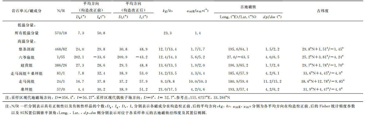
表 1 各采样单元不同磁成分平均方向及其相应统计参数以及古地磁极比较 Table 1 Summary of the low-temperature and high-temperature characteristic remanences and corresponding paleopoles and paleolatitudes for the studied section in the Xixia Basin |
再将分离得到的所有样品的高温特征分量投影在等面积投影图上,可以看出正、负极性都有.利用Fisher统计分别求出正极性与负极性方向的特征剩磁的Fisher平均,再分别删除在各极性中各剩磁分量与各自平均值之间离散度>40°的样品.用此方法将选出的550块样品高温特征分量,利用Fisher统计求取其平均方向及其相应统计参数(表 1)并将其投影在等面积投影图中(图 6).样品高温特征分量经过构造校正后,集中程度与构造校正前集中程度在误差范围内几乎没有变化,这是由于采样剖面位于单斜地层,因而产状改正前后数据的集中程度不会产生较大变化.
再将550块样品的特征剩磁方向按照岩石地层单位(分别为桑坪组、走马岗组、赵营组以及六爷庙组)进行分组,并分别对各组内样品的特征剩磁方向进行统计[33](图 7a,b,c),从而分别求得四个组的Fisher平均方向及其统计参数(表 1).
为进一步验证特征剩磁的原生性,对550块样品的特征剩磁(其中包括468块正极性样品与82块负极性样品)实施倒转检验[34],结果表明通过了B级倒转检验.综上所述,阳城-丹水剖面古地磁样品,ChRM正、负极性方向都有且通过B级倒转检验,说明从样品中分离得到的ChRM很可能代表了岩石形成时期获得的原生剩磁,表明古地磁结果比较可靠地记录了晚白垩世时期地磁场的方向.
6 磁性地层划分与对比在获得由550个采点样品的可靠特征剩磁方向后,建立由虚地磁极纬度(VGPLatitude)确定的磁极性变化序列(图 8).从剖面中至少可以清晰地识别出2个正极性带和2个负极性带,由新到老分别为R1,N1,R2,N2.应注意在剖面中下部N2内出现的几个负极性带以及在剖面上部R1内出现的一个正极性带,这些极性带都只是由单个样品的特征剩磁方向确定,对这种情形图中用“短半线”表示,表明其极性不确定.
蛋化石及其他古生物化石出露层位是地层重要的年代控制点.方晓思等[1~3]首次在盆地内发现了鳄类蛋、鸟类、龟类蛋化石和恐龙蛋以及长形蛋等新种蛋化石,其中恐龙蛋化石出露最高层位至剖面第88~89层(2311.72m~2346.04m)(图 8);根据蛋化石形态、结构等随剖面演化特征可能暗示晚白垩世时期古气候以及古环境变化对于生物演化的影响.同时在剖面第64层(1742.17 m)首次发现无脊椎动物叶肢介、介形虫、双壳类等化石[1~3],由此应将赵营组时代划分为晚白垩世[1~13].方晓思等[1~3]还将位于剖面西南方向的淅川-滔河盆地“高沟组和马家村组”与西峡盆地赵营组进行对比,并将该盆地寺沟组与西峡盆地六爷庙组对比.李罡等[13]将西峡盆地马家村组发现的新种Tylestheria xixiaensissp.nov与嫩江组一段化石进行对比,得出马家村组含新种蛋化石层位于Turonian阶,由此赵营组中、上部应位于Turonian阶.另有报道认为西峡盆地阳城-丹水剖面赵营组中上部以及六爷庙组时代应晚于Cenomanian期,属于晚白垩世中、晚期(Coniacian-Campanian期)[9, 13].
白垩纪期间古地磁场最显著的特征是“超静磁带”(Cretaceous NormalSuperchron,CNS)的出现[35~37](M0r以上跨越时限为118~83 Ma的正极性带),而剖面磁极性序列也具有一些明显特征,表现为地磁场极性变化少,从剖面底部到2973m处出现第一个负极性带,都可与“超静磁带”进行对比,这也是将剖面磁极性序列与标准地磁极性年表[35~37](Geomagnetic Polarity Time Scale,GPTS)进行对比的重要依据.
结合剖面古生物资料及其自身特征并与GPTS的对比,一种最为可能的对比方案是:从剖面底部桑坪组一直到赵营组中、上部(2973m处)出现的这一条连续的正极性带N2与GPTS中C34n进行对比.由于剖面底部未见明显的负极性带,因而可以推测剖面底部可能仍位于C34n当中.但考虑到剖面下部走马岗组以及赵营组中部夹有大套砾岩,沉积速率变化很大,且该段地层缺乏更为精细的古生物以及其他定年材料的佐证,因而剖面底部年龄无法确定.此外,在位于剖面下部分别约178.7~307.2m,310.6~538.2m以及691.4~962m三处范围内由于为大套砾岩出露层位(图 8所示灰色阴影区域),并未开展古地磁采样,因而无法提供这三段的磁极性序列,故在磁极性柱下部以“斜划线”符号表示,而结合上述讨论,仍将这三段划分至CNS内,因而可以认为这三段内的磁极性仍然为正极性.将剖面上部从赵营组2973 m处(正极性带N2结束)一直延至3023m处的负极性带R2与GPTS中C33r进行对比,并将正极性带N1与GPTS的C33n、C32r以及C32n进行对比.将剖面上部从3136m处开始一直到剖面顶部的负极性带R1都与C31r进行对比,且未见到R1顶部,因而剖面顶部年龄也无法确定.由此,根据磁极性变化序列与GPTS对比从而确定剖面正极性带N2结束位置处至负极性带R2结束位置处(剖面上部2973.18m至3023.41m)的年龄为83~79.075Ma,且正极性带N1结束处(3136.55m)对应年龄为71.071M,都位于坎潘(Campanian)阶(图 8).
计算该段剖面(2973.18m~3136.55m)沉积速率,约1.38cm/ka,相对于典型的前陆盆地沉积环境下的沉积速率(10~40cm/ka)[38~39]较低,从岩性上观察并未发现有较大变化.另外,从剖面开始到第77层(1969.69)岩性主要为砂质砾岩、粗砂岩并夹有大套砾岩,而从剖面第78层开始(1969.69m),岩性粒度整体开始变细,主要以泥岩、砂质泥岩和泥质粉砂岩为主,这可能反映了以河流相沉积转变为以湖相沉积为主的沉积环境的显著变化(图 2,图 8).
通过对地层岩性柱、蛋化石出露点以及磁极性序列三者对比(图 8),蛋化石(Dendroolithus sanlimiaoensis以及Dendroolithus furca fus种)出露最高层位为第88~89层(2311.72m~2346.04m),比剖面2973m至3023m处层位要低600m多,说明剖面蛋化石最高层位比目前国内外公认的含蛋化石以及微体古生物化石的白垩纪-第三纪界线要低[40~54],意味着西峡盆地上白垩统蛋化石(或恐龙化石)消失不晚于83Ma,暗示在中生代结束(65Ma)以前,西峡盆地大型爬行类动物(主要为恐龙及其蛋化石)就已经出现绝灭迹象,这比目前国际上认为的恐龙等大型爬行类动物绝灭的时间[40~54]要早.结合从剖面第78层开始(1969.69 m),岩性由以砾岩、砂质砾岩沉积转变到以细砂岩、泥岩为主,可能与晚白垩世时期,西峡盆地地区气候、环境发生较大变化有关而使得中生代末期该地区大型爬行类动物的绝灭.
7 古地磁极结果及讨论在获得550个采点特征剩磁平均方向以及各组(分别为桑坪组、走马岗组、赵营组和六爷庙组)特征剩磁平均方向后,计算得到相应的古地磁极及其统计结果(表 1,图 9)以及参考点(33.266°N,111.6757°E)古纬度及其置信区间(表 1),由于原属走马岗组下段的桑坪组以及走马岗组采点分布较少,因而将由这两个组获得的特征剩磁方向合在一起求取其Fisher平均,并由此平均方向及其相应统计参数求得综合走马岗组以及桑坪组两个组而获得古地磁极.将各采样单元古地磁极投影在等面积投影图上(图 9),除走马岗组及桑坪组古地磁极外,其余三个观测结果在95%置信水平上无法区分,表明在晚白垩世期间,采样剖面所在的西峡盆地很可能在构造上处于相对稳定期.这从另一个侧面也说明了研究剖面上大型爬行动物的灭绝与局部构造活动无关.同时,如图 9所示,白垩纪期间,华北、华南地块及与北部的西伯利亚板块之间,古地磁极位置在95%置信区间内几乎无法区分[55~56],表明华北与华南地块以及与北部的西伯利亚板块之间已经完成拼贴,在运动学上已经成为一个整体[55~62],大规模的陆内变形或局部运动主要发生于大陆边缘或块体的结合部位等[55~56, 63~65].由华北地块古地磁参考极[55]计算得到参考点处古纬度及其置信区间为32.27°N±4.7°,这与本次研究得到的参考点处古纬度间几乎没有差异,表明研究区与华北地块晚白垩世以来未发生明显纬向运动,也支持上述结论.

|
图 9 本次研究获得的古地磁极与华北及华南地块白垩纪古地磁极极位置[55]比较 1.本次研究中由整条剖面获得的古地磁极及其95%置信椭圆;2、3、4分别为桑坪组与走马岗组、赵营组、六爷庙组古地磁极及其相应的95%置信圆;5.华北地块白垩纪古地磁极;6和7分别为华南地块早白垩世和晚白垩世古地磁极. Fig. 9 Comparisons of the paleopoles obtained from this study with the paleopoles of the NCB and SCB in Late Cretaceous[55] Paleopole 1 with its ellipse represents the paleopole computed from the Fisherian mean characteristic direction from the samples of all levels and corresponding confidence ellipse in the studied section; Paleopoles 2, 3, 4 are the paleopoles obtained from the Fisherian mean characteristic direction from the samples of Sangping and Zoumagang, Zhaoying, Liuyemiao Formation respectively; Paleopole 5 is the paleopole for North China Block (NCB) in Cretaceous; Paleopoles 6 and 7 are the poles for South China Block (SCB) in Early and Late Cretaceous respectively. |
将来自所有550个采点样品的古地磁极与白垩纪时期华北地块古地磁极比较发现,自晚白垩世以来,研究区相对华北和华南地块分别发生了17.8°±4.8°,18.0°±5.81°的顺时针旋转,由于研究区构造格架主要是由秦岭主造山期以及后主造山期两期复合所构成的东西走向,以自北向南为主导的复合型逆冲推覆构造[10]所控制,因而研究区相对于华北、华南地块的顺时针旋转可能与该处的局部构造活动,如断层错动相关.
8 结论由此得到以下结论:(1)西峡盆地阳城-丹水剖面稳定剩磁载体以赤铁矿和磁铁矿为主,特征剩磁通过了倒转检验,很可能为记录岩石形成时期的原生剩磁;(2)结合剖面古生物资料,磁性地层学结果表明该剖面上部2973.18~3136.55 m处地质年代为83~71.071 Ma.该剖面发现的蛋化石最高层位比目前国内外公认的白垩纪-第三纪界线要低,表明盆地上白垩统蛋化石(或是恐龙等)的绝灭(或消失)不晚于83 Ma,可能与西峡地区晚白垩世气候、环境变化有关;(3)自晚白垩世以来,研究区相对华北地块几乎并未发生较明显的纬向运动,但相对华北和华南地块分别发生了17.8°±4.8°和18.0°±5.81°的顺时针旋转,可能由该地区的局部构造活动引起.
致谢感谢新疆地质矿产研究所李永安教授和中国地质调查局成都地质矿产研究所庄忠海研究员在野外采样过程中所提供的大力帮助;与本所古地磁与年代学实验室秦华峰、陈军山、敖红以及孙丽莎等的讨论给了作者很多启发;同时,两位审稿人对本文提出修改意见给了作者很多指导及帮助,提升了本文的质量,在此一并表示感谢.
| [1] | 方晓思, 程政武, 张志军, 等. 豫西南-鄂西北-带恐龙蛋化石演化序列与环境变迁. 地球学报 , 2007, 28(2): 97–110. Fang X S, Cheng Z W, Zhang Z J, et al. Evolutionary Series of Dinosaur eggs and environmental changes in southwestem Henan-northwestern Hubei. Acta Geoscientica Sinica (in Chinese) , 2007, 28(2): 97-110. |
| [2] | 方晓思, 张志军, 庞其清, 等. 河南西峡白垩纪地层和蛋化石. 地球学报 , 2007, 28(2): 123–142. Fang X S, Zhang Z J, Pang Q Q, et al. Cretaceous strata and egg fossils in Xixia, Henan Province. Acta Geoscientica Sinica (in Chinese) , 2007, 28(2): 123-142. |
| [3] | 方晓思, 岳昭, 凌虹. 近十五年来蛋化石研究概况. 地球学报 , 2009, 30(4): 523–542. Fang X S, Yue Z, Ling H. Review of the Past 15 Years'Research on Fossil Eggs in China. Acta Geoscientica Sinica (in Chinese) , 2009, 30(4): 523-542. |
| [4] | 王德有, 罗铭玖, 周世全, 等. 西峡盆地晚白垩世古气候初探. 河南地质 , 1994, 12(3): 182–188. Wang D Y, Luo M J, Zhou S Q, et al. The preliminary research of Late Cretaceous Paleoclimate in Xixia Basin. Henan Ceology (in Chinese) , 1994, 12(3): 182-188. |
| [5] | 程政武, 方晓思, 王益民, 等. 河南西峡盆地产恐龙蛋地层研究新进展. 科学通报 , 1995, 40(16): 1487–1490. Cheng Z W, Fang X S, Wang Y M, et al. New advancement on the research of Cretaceous dinosaur-egg-bearing beds in Xixia Basin, Henan. Chinese Science Bulletin (in Chinese) , 1995, 40(16): 1487-1490. |
| [6] | 张国成. 河南西峡晚白垩世盆地的沉积演化. 焦作工学院学报(自然科学版) , 2002, 21(2): 85–90. Zhang G C. Evolution of the Late Cretaceous depositional systems in the Xixia Basin. Henan Province.Journal of Jiaozuo Institute of Technology-Natural Science (in Chinese) , 2002, 21(2): 85-90. |
| [7] | 王德有, 陈丕基, 陈金华, 等. 河南西峡盆地含恐龙蛋地层中无脊椎动物化石的首次发现. 古生物学报 , 2006, 45: 494–497. Wang D Y, Chen P J, Chen J H, et al. Discovery of Invertebrate Fossils from the Dinosaurian egg-bearing strata in the Xixia Basin of Henan, China. Acta Palaeontologica Sinica (in Chinese) , 2006, 45: 494-497. |
| [8] | 陈金华, 王德有, 冯进程, 等. 河南西峡盆地晚白垩世含恐龙蛋地层中的双壳类. 古生物学报 , 2007, 46(3): 299–313. Chen J H, Wang D Y, Feng J C, et al. Late Cretaceous nonmarine bivalves from the Dinosaur egg-bearing strata of Xixia Basin, Henan, China. Acta Palaeontologica Sinica (in Chinese) , 2007, 46(3): 299-313. |
| [9] | 潘华璋, 王德有, 冯进程, 等. 河南两峡盆地晚白垩世含恐龙蛋地层中的腹足类. 古生物学报 , 2007, 46(3): 293–298. Pan H Z, Wang D Y, Feng J C, et al. Late Cretaceous nonmarine gastropoda from the Dinosaur egg-bearing strata of Xixia Basin, Henan, China. Acta Palaeontologica Sinica (in Chinese) , 2007, 46(3): 293-298. |
| [10] | 宋慧波, 胡斌, 王德有, 等. 河南西峡盆地上白垩统高沟组沉积特征与沉积环境. 石油地质与工程 , 2008, 22(4): 1–6. Song H B, Hu B. Wang D Y, et al. Sedimentary Characteristics and environments of Gaogou Formation of Upper Cretaceous in Xixia Basin, Henan.Petroleum Geology and Engineering (in Chinese) , 2008, 22(4): 1-6. |
| [11] | 庞其清, 张志军, 卢立伍, 等. 河南西峡地区晚白垩世介形虫的发现及其地层意义. 地质通报 , 2008, 27(6): 769–784. Pang Q Q, Zhang Z J, Lu L W, et al. Discovery of Late Cretaceous ostracods in Xixia, Henan China, and its stratigraphic significance. Geological Bulletin of China (in Chinese) , 2008, 27(6): 769-784. |
| [12] | 张国成, 郭卫星, 曾玉凤. 河南西峡盆地上白垩统河流及湖泊沉积中的遗迹组构. 古地理学报 , 2004, 6: 434–441. Zhang G C, Guo W X, Zeng Y F. Ichnofabric characteristics of fluvial and lacustrine sediments of the Upper Cretaceous in Xixia Basin. Henan Province.Journal of Palaeogeography (in Chinese) , 2004, 6: 434-441. |
| [13] | Li G, Chen P J, Wang D Y, et al. The spinicaudatan Tylestheria and biostratigraphic significance for the age ofdinosaur eggs in the Upper Cretaceous Majiacun Formation, Xixia Basin, Henan Province, China. Cretaceous Research , 2009, 30: 477-482. DOI:10.1016/j.cretres.2008.09.002 |
| [14] | He H Y, Wang X L, Zhou Z H, et al. Ar40/Ar39 dating of ignimbrite from Inner Mongolia, northeastern China, indicates a post-Middle Jurassic age for the overlying Daohugou Bed. Geophysical Research Letters , 2004, 31: L20609. DOI:10.1029/2004GL020792 |
| [15] | Zhu R X, Hoffman K A, Potts R, et al. Earliest presence of humans in northeast Asia. Nature , 2001, 413: 413-417. DOI:10.1038/35096551 |
| [16] | Zhu R X, Potts R, Xie F, et al. New evidence on the earliest human presence at high northern latitudes in northeast Asia. Nature , 2004, 431: 559-562. DOI:10.1038/nature02829 |
| [17] | Guo Z T, Ruddiman W F, Hao Q Z, et al. Onset of Asian desertification by 22 Myr ago inferred from loess deposition in China. Nature , 2002, 416: 159-163. DOI:10.1038/416159a |
| [18] | Sun J M, Zhu R X, Bowler J. Timing of the Tianshan Mountains uplift constrained by magnetostratigraphic analysis of molasse deposits. Earth and Planetary Science Letters , 2004, 219: 239-253. DOI:10.1016/S0012-821X(04)00008-1 |
| [19] | Sun Z M, Yang Z Y, Pei J L, et al. Magnetostratigraphy of Paleogene sediments from northern Qaidam Basin, China:Implications for tectonic uplift and block rotation in northern Tibetan plateau. Earthand Planetary Science Letters , 2005, 237: 635-646. DOI:10.1016/j.epsl.2005.07.007 |
| [20] | Charreau J, Chen Y, Gilder S, et al. Magnetostratigraphy and rock magnetism of the Neogene Kuitun He section (northwest China):implications for Late Cenozoic uplift of the Tianshan mountains. Earth and Planetary Science Letters , 2005, 230: 177-192. DOI:10.1016/j.epsl.2004.11.002 |
| [21] | Charreau J, Gilder S, Chen Y, et al. Magnetostratigraphy of the Yaha section, Tarim Basin (China):11 Ma acceleration in erosion and uplift of the Tian Shan mountains. Geology , 2006, 34(3): 181-184. DOI:10.1130/G22106.1 |
| [22] | Huang B C, Piper J D A, Peng S T, et al. Magnetostratigraphic study of the Kuche Depression, Tarim Basin, and Cenozoic uplift of the Tian Shan Range, Western China. Earth and Planetary Science Letters , 2006, 251: 346-364. DOI:10.1016/j.epsl.2006.09.020 |
| [23] | Fang X M, Zhang W L, Meng Q Q, et al. High-resolution magnetostratigraphy of the Neogene Huaitoutala section in the eastern Qaidam Basin on the NE Tibetan Plateau, Qinghai Province, China and its implication on tectonic uplift of the NE Tibetan Plateau. Earth and Planetary Science Letters , 2007, 258: 293-306. DOI:10.1016/j.epsl.2007.03.042 |
| [24] | Huang B C, Piper J D A, Qiao Q Q, et al. Magnetostratigraphic and rock magnetic study of the Neogene upper Yaha Section, Kuche Depression (Tarim Basin):Implications to formation of the Xiyu Conglomerate Formation, NW China. Journal of Geophysical ResearchSolid Earth , 2010, 115(B01101): 1-17. DOI:10.1029/2008JB006175 |
| [25] | 河南省地质矿产局. 河南省区域地质志. 北京: 地质出版社, 1989 : 245 -257. Bureau of Geology and Mineral Resources of Henan Province (BGMRH). Regional geology of Henan Province (in Chinese). Beijing: Geological Publishing House, 1989 : 245 -257. |
| [26] | Lowrie W. Identification of ferromagnetic minerals in a rock coercivity and unblocking temperature properties. Geophysical Research Letters , 1990, 17: 159-162. DOI:10.1029/GL017i002p00159 |
| [27] | Dunlop D J, Ozdemir O. Rock Magnetism:Fundamentals and Frontiers. Cambridge (UK):Cambridge University Press , 1997: 74-76. |
| [28] | Lowrie W, Heller F. Magnetic Properties of Marine Limestones. Reviews of Geophysics and Space Physics , 1982, 20: 171-192. DOI:10.1029/RG020i002p00171 |
| [29] | Holm Eric J, Verosub K L. An analysis of the effects of Thermal Demagnetization on Magnetic Carriers. Geophysical Research Letters , 1988, 15: 487-490. DOI:10.1029/GL015i005p00487 |
| [30] | Kirschvink J L. The least-squares line and plane and the analysis of paleomagnetic data. Geophysical Journal of Royal Astronomical Society , 1980, 62: 699-718. DOI:10.1111/gji.1980.62.issue-3 |
| [31] | Zijdervclcl J D A.AC demagnetization of rocks:analysis of results.In:Collinson D W, Creer K M, Runcorn S K (Eds).Methods in Paleomagnetism.New York:Elsevier, 1967.254~286 |
| [32] | Halls C. The use of converging remagnetization circles in paleomagnetism. Physics of the Earth and Planetary Interiors , 1978, 16: 1-11. DOI:10.1016/0031-9201(78)90095-X |
| [33] | Fisher R A. Dispersion on a sphere. Proceedings of the Royal Society, London (Series A) , 1953, 217: 295-305. DOI:10.1098/rspa.1953.0064 |
| [34] | McFadden P L, McElhinny M W. Classification of the reversal test in paleomagnetism. Geophysical Journal International , 1990, 103: 725-729. DOI:10.1111/gji.1990.103.issue-3 |
| [35] | Opdyke N D, Channell J E T. Magnetic Stratigraphy. San Diego: Academic Press, 1996 : 182 -195. |
| [36] | Cande S C, Kent D V. Revised calibration of the geomagnetic polarity time scale for the Late Cretaceous and Cenozoic. Journal of Geophysical Research-Solid Earth , 1995, 100: 6093-6095. DOI:10.1029/94JB03098 |
| [37] | Gradstein F M, Ogg J G, Smith A G.(Eds.) A Geologic Time Scale.U.K.:Cambridge University Press, 2004 |
| [38] | Burbank D W, Verges J, Munoz J A, et al. Coeval hindward-and forward-imbricating thrusting in the southcentral Pyrenees, Spain:Timing and rates of shortening and deposition. Geological Society of America Bulletin , 1992, 104: 3-17. DOI:10.1130/0016-7606(1992)104<0003:CHAFIT>2.3.CO;2 |
| [39] | Harrison T M. Copeland P, Hall S A, et al. Isotopic preservation of himalayan/tibetan uplift, denudation, and climatic histories of two molasse deposits.Journal of Geology , 1993, 101: 157-175. |
| [40] | Alvarez L W. Alvarez W, Asaro F, et al. Extraterrestrial cause for the cretaceous-tertiary extinction.Science , 1980, 208(4448): 1095-1108. |
| [41] | Macdougall J D. Seawater strontium isotopes, acid rain, and the Cretaceous-Tertiary Boundary. Science , 1988, 239: 485-487. DOI:10.1126/science.239.4839.485 |
| [42] | Courtillot V, Feraud G, Maluski H. Deccan flood basalts and the Cretaceous-Tertiary boundary. Nature , 1988, 333(30): 843-846. |
| [43] | Ortega-Huertas M, Martinez-Ruiz F, Palomo I, et al. Review of the mineralogy of the Cretaceous-Tertiary boundary clay:evidence supporting a major extraterrestrial catastrophic event. Clay Minerals , 2002, 37: 395-411. DOI:10.1180/0009855023730054 |
| [44] | Ellwood B B, MacDonald W D, Wheeler C, et al. The K-T boundary in Oman:identified using magnetic susceptibility field measurements with geochemical confirmation. Earth and Planetary Science Letters , 2003, 206: 529-540. DOI:10.1016/S0012-821X(02)01124-X |
| [45] | Keller G, Adatte T, Stinnesbeck W, et al. Chicxulub impact predates the K-T boundary mass extinction. Proceedings of the National Academy of Sciences , 2004, 101(11): 3753-3758. DOI:10.1073/pnas.0400396101 |
| [46] | Kring D A. The Chicxulub impact event and its environmental consequences at the Cretaceous-Tertiary boundary. Palaeogeography, Palaeoctimatology, Palaeoecology , 2007, 255: 4-21. DOI:10.1016/j.palaeo.2007.02.037 |
| [47] | Nichols D J. Selected plant microfossil records of the terminal Cretaceous event in terrestrial rocks, western North America. Palaeogeography, Pataeoclimatology, Palaeoecology , 2007, 255: 22-34. DOI:10.1016/j.palaeo.2007.02.038 |
| [48] | Harvey M C, Brassell S C, Belcher C M, et al. Combustion of fossil organic matter at the Cretaceous-Paleogene (K-P) boundary. Geology , 2008, 36(5): 355-358. DOI:10.1130/G24646A.1 |
| [49] | Keller G, Adatte T, Gardin S, et al. Main Deccan volcanism phase ends near the K-T boundary:Evidence from the Krishna-Godavari Basin, SE India. Earth and Planetary Science Letters , 2008, 268: 293-311. DOI:10.1016/j.epsl.2008.01.015 |
| [50] | Parthasarathy G, Bhandari N, Vairamani M, et al. Highpressure phase of natural fullerene C60 in iridium-rich Cretaceous-Tertiary boundary layers of Deccan intertrappean deposits, Anjar, Kutch, India. Geochimica et Cosmochimica Acta , 2008, 72: 978-987. DOI:10.1016/j.gca.2007.12.003 |
| [51] | Celâl Sengör A M, Atayman S, Ozeren S. A scale of greatness and causal classification of mass extinctions:Implication for mechanisms. Proceedings of the National Academy of Sciences , 2008, 105(37): 13736-13740. DOI:10.1073/pnas.0805482105 |
| [52] | Keller G, Abramovich S, Bemer Z, et al. Biotic effects of the Chicxulub impact, K-T catastraphe and sea level change in Texas. Palaeogeography, Palaeoclimatology, Palaeoecology , 2009, 271: 52-68. DOI:10.1016/j.palaeo.2008.09.007 |
| [53] | Keller G, Adatte T, Bajpai S, et al. K-T transition in Deccan Traps of central India marks major marine Seaway across India. Earth and Planetary Science Letters , 2009, 282: 10-23. DOI:10.1016/j.epsl.2009.02.016 |
| [54] | Alvarez W. The historical record in the Scaglia limestone at Gubbio:magnetic reversals and the Cretaceous-Tertiary mass extinction. Sedimentology , 2009, 56: 137-148. DOI:10.1111/sed.2008.56.issue-1 |
| [55] | 黄宝春, 周姚秀, 朱日祥. 从谷地磁研究看中国大陆形成与演化过程. 地学前缘 , 2008, 15(3): 348–359. Huang B C, Zhou Y X, Zhu R X. Discussions on Phanerozoic evolution and formation of continental China, based on paleomagnetic studies. Earth Science Frontiers (in Chinese) , 2008, 15(3): 348-359. |
| [56] | Huang B C, Piper J D A, Zhang C X, et al. Paleomagnetism of Cretaceous rocks in the Jiaodong Peninsula. eastern China:Insight into block rotations and neotectonic deformation in eastern Asia.Journal of Geophysical Research-Solid Earth , 2007, 112: B03101. DOI:10.1029/2006JB004462 |
| [57] | Zhao X X, Coe R S. Palaeomagnetic constraints on the collision and rotation of North and South China. Nature , 1987, 327(6118): 141-144. DOI:10.1038/327141a0 |
| [58] | Huang K N, Opdyke N D. Paleomagnetism of Jurassic rocks from southwestern Sichuan and the timing of the closure of the Qinling Suture. Tectonophysics , 1991, 200: 299-316. DOI:10.1016/0040-1951(91)90021-J |
| [59] | Ma X H, Yang Z Y, Xing L S. The Lower Cretaceous reference pole for North China, and its tectonic implications. Geophysical Journal International , 1993, 115(1): 323-331. DOI:10.1111/gji.1993.115.issue-1 |
| [60] | Gilder S A, Courtillot V. Timing of the North-South China collision from new middle to late Mesozoic paleomagnetic data from the North China Block. Journal of Geophysical Research-Solid Earth , 1997, 102(B8): 17713-17727. DOI:10.1029/97JB01201 |
| [61] | Yang Z Y, Besse J. New Mesozoic apparent polar wander path for south China:Tectonic consequences. Journal of Geophysical Research-Solid Earth , 2001, 106(B5): 8493-8520. DOI:10.1029/2000JB900338 |
| [62] | Uno K, Huang B C. Constraints on the Jurassic swing of the apparent polar wander path for the North China Block. Geophysical Journal International , 2003, 154: 801-810. DOI:10.1046/j.1365-246X.2003.01992.x |
| [63] | Gilder S A, Leloup P H, Courtillot V, et al. Tectonic evolution of the Tancheng-Lujiang (Tan-Lu) fault via Middle Triassic to Early Cenozoic paleomagnetic data. Journal of Geophysical Research-Solid Earth , 1999, 104(B7): 15365-15390. DOI:10.1029/1999JB900123 |
| [64] | Zhao X X, Coe R S, Chang K-H, et al. Clockwise rotations recorded in Early Cretaceous rocks of South Korea:implications for tectonic affinity between the Korean Peninsula and North China. Geophysical Journal International , 1999, 139: 447-463. DOI:10.1046/j.1365-246x.1999.00944.x |
| [65] | Lin W, Chen Y, Faure M, et al. Tectonic implications of new Late Cretaceous paleomagnetic constraints from Eastern Liaoning Peninsula, NE China. Journal of Geophysical Research-Solid Earth , 2003, 108(B6): 2313. DOI:10.1029/2002JB002169 |